
 California Highways:
Click here for a key to the symbols used. An explanation of acronyms may be found at the bottom of the page.
 Routing
 Post 1964 Signage History
In 1972, Chapter 748 defined Route 269 as "Route 33 at Avenal to Route 145 near Five Points."
Route 269 is a 30 mile state highway running from Route 33 at Avenal in
Kings County north to Route 145 at Five Points in Fresno County. Route 269
traverses the outskirts of the Diablo Range and Kettelman Hills before the
descending northward into San Joaquin Valley along the duration of the
alignment. There are major junctions with the Avenal Cut-Off Road, I-5 and
Route 198 in addition to the termination points described above. Route 269
is a relatively new state road. The highway alignment was adopted off
pre-existing roadways in 1972. Although adopted in 1972, it does not
appear that the entirety of what is now Route 269 was upgraded to state
highway standards until sometime between 1978 and 1979. It appears that
the State Highway may have been in part built to service Avenal State
Prison which opened in the late 1980s. From Route 33 in Avenal, Route 269
is known as Skyline Blvd north to I-5. A 1935 County Map of Kings County
show Skyline Blvd existing but in a much curvier alignment in the
Kettelman Hills which is now known as Old Skyline Blvd and occupied
largely by oil rigs. From I-5 north to Route 145 in Five Points is known
as Lassen Avenue and largely just a direct north/south run through San
Joaquin Valley. Five Points apparently was founded some time before World
War II as a possible stopping point along the Fresno-Coalinga Road which
would eventually become part of Route 145. It appears that Five Points is
named after the five pointed junction of Mount Whitney Avenue,
Fresno-Coalinga Road, and Lassen Avenue.
(Source: Tom Fearer (Max Rockatansky). on AARoads, April 2017)
 Pre 1964 Signage History
This routing was first defined post 1963.
 Status
Heron Bridges
 In May 2018, the CTC approved for future consideration of
funding the following project for which a Mitigated Negative Declaration
(MND) has been completed: Route 269 in Fresno County. Construct roadway
improvements including replacing three bridges near the city of Heron.
(PPNO 2184) (06-Fre-269, PM 10.4/12.5) This project is located on Route 269, north of Heron in Fresno County. The project proposes to raise the
profile grade and construct three bridges. Winter storms have caused
flooding and closure of Route 269 an average of 22 days per year since
1978. The proposed project will eliminate traffic detour going in and out
of Heron due to flooding. The proposed project is estimated to cost $18.5
million in construction. This project is fully funded and is currently
programmed in the 2018 SHOPP for $27.5 million which includes Construction
(capital and support) and Right-of-Way support. Additional funding of $1.2
million is anticipated from local Measure funds for Right-ofWay.
Construction is estimated to begin in FY 2018-19. The scope, as described
for the preferred alternative, is consistent with the project scope
programmed by the Commission in the 2016 SHOPP.
In May 2018, the CTC approved for future consideration of
funding the following project for which a Mitigated Negative Declaration
(MND) has been completed: Route 269 in Fresno County. Construct roadway
improvements including replacing three bridges near the city of Heron.
(PPNO 2184) (06-Fre-269, PM 10.4/12.5) This project is located on Route 269, north of Heron in Fresno County. The project proposes to raise the
profile grade and construct three bridges. Winter storms have caused
flooding and closure of Route 269 an average of 22 days per year since
1978. The proposed project will eliminate traffic detour going in and out
of Heron due to flooding. The proposed project is estimated to cost $18.5
million in construction. This project is fully funded and is currently
programmed in the 2018 SHOPP for $27.5 million which includes Construction
(capital and support) and Right-of-Way support. Additional funding of $1.2
million is anticipated from local Measure funds for Right-ofWay.
Construction is estimated to begin in FY 2018-19. The scope, as described
for the preferred alternative, is consistent with the project scope
programmed by the Commission in the 2016 SHOPP.
(Source: CTC Agenda, May 2018 Agenda Item 2.2c(1))
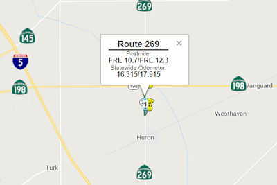
In June 2018, the CTC approved the following
allocation: $25,260,000 Fresno 06-Fre-269 10.7/12.3. PPNO 2184. On Route 269, Near Huron, from 1.1 miles north of Palmer Avenue to 0.4 miles south
of Route 198. Outcome/Output: Raise highway profile and reconstruct three
bridges.
(Source: CTC Agenda, June 2018 Agenda Item 2.5b(1) Item 31)
 Naming
 The portion of Route 269
from Route 198 to the City of Five Points in Fresno County (~ FRE 12.943
to FRE 24.704) is named the "Officer John Palacios Memorial Highway".
This segment was named in memory of Officer John Palacios, who faithfully
served the residents of the City of Huron in Fresno County as an officer
of the Huron Police Department. Officer Palacios died in the line of duty
at 21 years of age on June 13, 1976, when he was assisting the California
Highway Patrol with a traffic accident on Route 269 in Huron, California,
when he was struck and killed by a drunk driver. Named by Senate
Concurrent Resolution (SCR) 14, Resolution Chapter 92, on 7/12/2007.
The portion of Route 269
from Route 198 to the City of Five Points in Fresno County (~ FRE 12.943
to FRE 24.704) is named the "Officer John Palacios Memorial Highway".
This segment was named in memory of Officer John Palacios, who faithfully
served the residents of the City of Huron in Fresno County as an officer
of the Huron Police Department. Officer Palacios died in the line of duty
at 21 years of age on June 13, 1976, when he was assisting the California
Highway Patrol with a traffic accident on Route 269 in Huron, California,
when he was struck and killed by a drunk driver. Named by Senate
Concurrent Resolution (SCR) 14, Resolution Chapter 92, on 7/12/2007.
(Image source: Gribblenation; Find a Grave)
 Named Structures
 The 500-foot long bridge over Arroyo Pasajero Creek on Route 269 (~ FRE 269 10.4/FRE 269
12.5) is named the Heart of the Valley Bridge. It was named in
memory of seven residents of Fresno County who lost their lives on I-5 on
March 12, 1995 when Route 269 was closed due to roadway collapse and
raging flood waters. Route 269 passes through the rural community of
Huron, California, and connects to I-5. Between the time when Route 269
came into the state highway system in 1976 and 2020, it had been closed
over 551 days due to flooding. Because Route 269 is the only access to the
community of Huron from the north, community residents must travel a
28-mile detour for shopping and services, including for medical
emergencies, during road closures. Residents of Huron and the surrounding
rural communities depend on Route 269 to keep them connected to the rest
of the Central Valley by way of Route 198 and I-5. The Route 269 Bridge
Project will create a reliable and safe corridor for the local and
regional motoring public. The construction of three new bridges and
modification of the Arroyo Pasajero Creek channel will prevent future
closure of the highway due to flooding. Named by Assembly Concurrent
Resolution (ACR) 124, Res. Chapter 40, 09/14/20.
The 500-foot long bridge over Arroyo Pasajero Creek on Route 269 (~ FRE 269 10.4/FRE 269
12.5) is named the Heart of the Valley Bridge. It was named in
memory of seven residents of Fresno County who lost their lives on I-5 on
March 12, 1995 when Route 269 was closed due to roadway collapse and
raging flood waters. Route 269 passes through the rural community of
Huron, California, and connects to I-5. Between the time when Route 269
came into the state highway system in 1976 and 2020, it had been closed
over 551 days due to flooding. Because Route 269 is the only access to the
community of Huron from the north, community residents must travel a
28-mile detour for shopping and services, including for medical
emergencies, during road closures. Residents of Huron and the surrounding
rural communities depend on Route 269 to keep them connected to the rest
of the Central Valley by way of Route 198 and I-5. The Route 269 Bridge
Project will create a reliable and safe corridor for the local and
regional motoring public. The construction of three new bridges and
modification of the Arroyo Pasajero Creek channel will prevent future
closure of the highway due to flooding. Named by Assembly Concurrent
Resolution (ACR) 124, Res. Chapter 40, 09/14/20.
(Image source: Huron Mayor Ray Leon FB Page)
 Other WWW Links
 Statistics
Overall statistics for Route 269:
 Pre-1964 Legislative Route
In 1959, Chapter 1062 defined LRN 269 as “[LRN 61] to [LRN 23] south of Palmdale.” This was Route 196 between 1964 and 1965, and is currently Angeles Forest Highway, Los Angeles County Sign Route N3, from Route 2 to Route 14 south of Palmdale. .
© 1996-2020 Daniel P. Faigin.
Maintained by: Daniel P. Faigin
<webmaster@cahighways.org>.
 From Route
  Route 268
 Route 270