
 California Highways:
Click here for a key to the symbols used. An explanation of acronyms may be found at the bottom of the page.
 Routing
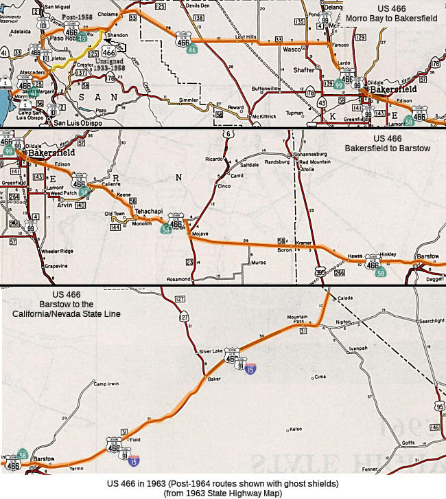 No current routing. Note that the map to the right does not show some of the
reroutings near Atascadero and Paso Robles, which are explained in the
next map.
No current routing. Note that the map to the right does not show some of the
reroutings near Atascadero and Paso Robles, which are explained in the
next map.
 Post 1964 Signage History
Route 466 was never defined legislatively.
As part of the renumbering in 1964, signage of US 466 was truncated to
end in Baker (California Route 58, former US 466, ended in Barstow). This
truncation would see US 466 terminate on Baker Boulevard at the
intersection with Route 127/Death Valley Road. See the linked
Gribblenation blog for more details, including links to maps and
pictures.
(Source: Gribblenation Blog (Tom Fearer), “Interstate 15; the Mojave Freeway from Barstow to the Nevada State Line”, April 2021; “Former US Route 91 and US Route 466 in Baker”, April 2021)
In 1965, a 18 mile segment of I-15 created a bypass of Baker. The bypass
route of US 91/I-15 would move the terminus of US 466 in Baker to the
Route 127 Exit at Death Valley Road.
(Source: Gribblenation Blog (Tom Fearer), “Former US Route 91 and US Route 466 in Baker”, April 2021)
In 1971, US 466 was eliminated as a US Route by the AASHO Executive
Committee. This request was made by the Division of Highways in
reference to the remaining segment of US 466 multiplexed with I-15 to
Route 127 in Baker.
(Source: Gribblenation Blog (Tom Fearer), “Interstate 15; the Mojave Freeway from Barstow to the Nevada State Line”, April 2021)
 Pre 1964 Signage History
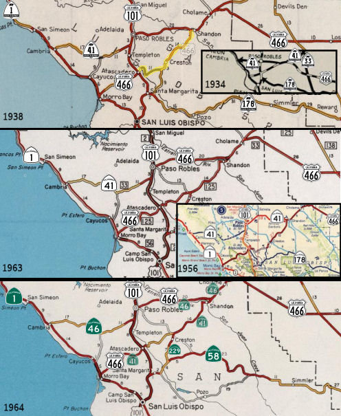 The first intimations of what would become
US 466 were under a different number. In 1933, US 64 had been extended
west to Santa Fe. Pressure began to extend the route all the way to the
West Coast from highway officials in New Mexico, Arizona, California (and
even North Carolina, where the east terminus of the route is located).
Specifically, during June 1933 the California Division of Highways
petitioned the American Association of State Highway Officials (then
AASHO, now AASHTO) for an extension of US 64 west of Raton, New Mexico to
Morro Bay, California. AASHO didn't like this idea, as it required
cosigning a large portion of the route with US 66. However, they did vote
on it. AASHO raised the objection that US 64 would have to be
dual-signed with US 66 for hundreds of miles, but nevertheless they put
the proposal to a vote at their August meeting. The majority of the
committee voted to not extend US 64, but instead to create a new US route
designation only along the segment that was separate from US 66 (i.e.,
starting in Barstow (written erroneously as "Blythe") through to Morro
Bay. It was assigned US 466. The Division of Highways via telegram to
AASHO dated August 10, 1933, expressed that such a short US Route located
entirely in-state would not provide the same utility as their US 64
extension proposal. California eventually relented, when during the
October 1933 AASHO meeting a compromise was reached. This compromise
created a US 466 that began at US 66 in Kingman, Arizona and travelled
northwest to the site of Boulder Dam at the Nevada state line. It then
multiplexed US 91 between Las Vegas and Barstow. Within California,
US 466 retained the same Barstow-Morro Bay alignment desired by the
California Division of Highways for their US 64 extension
proposal. US 466 was commissioned in 1933, effective the first
day of 1934, with an eastern end in Kingman AZ.
The first intimations of what would become
US 466 were under a different number. In 1933, US 64 had been extended
west to Santa Fe. Pressure began to extend the route all the way to the
West Coast from highway officials in New Mexico, Arizona, California (and
even North Carolina, where the east terminus of the route is located).
Specifically, during June 1933 the California Division of Highways
petitioned the American Association of State Highway Officials (then
AASHO, now AASHTO) for an extension of US 64 west of Raton, New Mexico to
Morro Bay, California. AASHO didn't like this idea, as it required
cosigning a large portion of the route with US 66. However, they did vote
on it. AASHO raised the objection that US 64 would have to be
dual-signed with US 66 for hundreds of miles, but nevertheless they put
the proposal to a vote at their August meeting. The majority of the
committee voted to not extend US 64, but instead to create a new US route
designation only along the segment that was separate from US 66 (i.e.,
starting in Barstow (written erroneously as "Blythe") through to Morro
Bay. It was assigned US 466. The Division of Highways via telegram to
AASHO dated August 10, 1933, expressed that such a short US Route located
entirely in-state would not provide the same utility as their US 64
extension proposal. California eventually relented, when during the
October 1933 AASHO meeting a compromise was reached. This compromise
created a US 466 that began at US 66 in Kingman, Arizona and travelled
northwest to the site of Boulder Dam at the Nevada state line. It then
multiplexed US 91 between Las Vegas and Barstow. Within California,
US 466 retained the same Barstow-Morro Bay alignment desired by the
California Division of Highways for their US 64 extension
proposal. US 466 was commissioned in 1933, effective the first
day of 1934, with an eastern end in Kingman AZ.
[More details, including excerpts from AASHO documents and maps, may
be found in the source links]
(Source: USends.Com, “End of historic US highway 466”, March 2022; Gribblenation Blog (Tom Fearer), "Paper Highways: US Route 64 to Morro Bay, California", 8/7/2023)
Within California, US 64 as originally proposed would have split from US 66 in Barstow and followed LRN 58 west over Tehachapi Pass to
Bakersfield. From Bakersfield, proposed US 64 would follow US 99
north along LRN 4 to Famoso. From Famoso, proposed US 64 would
follow LRN 33 west over the Polino Pass to Cholame. From Cholame,
proposed US 64 was to follow LRN 125 to Morro Bay by way of Shandon,
Creston, Rocky Canyon and Atascadero.
(Source: Gribblenation Blog (Tom Fearer), "Paper Highways: US Route 64 to Morro Bay, California", 8/7/2023)
In 1934, signed US 466 was commissioned, running over a variety of
legislative routes. Until July 1, 1964, the following route was signed as
US 466:
(Source: Tom Fearer (Max Rockatansky) and the crew at AARoads for helping to sort this out)
Present-day Route 41 between Route 1 and US 101 near Atascadero. This was LRN 125, defined in 1933.
Tom Fearer, in the referenced Gribblenation Blog, did extensive
research on the routing of US 466: US 466/LRN 125 began at Route 1 at
the corner of Main Street and Atascadero Road in Morro Bay. US 466/LRN 125 followed Morro Creek and Atascadero Creek eastward on
Atascadero Road to the City Limits of Atascadero. US 466/LRN 125
entered the City of Atascadero on Morro Road. Within the City of
Atascadero US 466/LRN 125 briefly multiplexed US 101/El Camino Real to
West Mall.
(Source: Gribblenation Blog (Tom Fearer),
“Legacy of US Route 466 Part 3; Morro Bay to Shandon (California State Route 229 and 41)”, May 2021)
Prior to 1958, LRN 125 between Atascadero and Shandon (highlighted in yellow on the map).
It appears that from 1933 through 1958, US 466 was aligned from
downtown Atascadero eastward through Rocky Canyon towards Creston and
Shandon. This initial alignment of US 466 was apparently never
signed, as it included a dirt segment through Rocky Canyon that had
been added into the State Highway System in 1933 as part of LRN 125.
US 466 in 1958 was shifted west of Shandon to Atascadero via a
multiplex of Route 41 west to Paso Robles and southbound US 101. This
alignment swap of US 466 was requested by the California Division of
Highways to the AASHO upon the completion of an upgrade to Route 41
(LRN 33) between Shandon and Paso Robles. In 1962, maintenance of LRN 125 through Rocky Canyon was transferred to San Luis Obispo County. In
time, former US 466 through Rocky Canyon was abandoned and eroded
away. Much of the former right of way of US 466 in Rocky Canyon
is now occupied by the CalPortland Rocky Canyon Quarry and Rocky
Canyon Trail.
(Source: FB Post from Tom Fearer, 5/21/2021)
Tom Fearer, in the referenced Gribblenation Blog, did extensive
research on the routing of US 466 prior to 1958: US 466/LRN 125
followed West Mall to the 1921 Atascadero Creek Bridge and
transitioned onto Capistrano Avenue. US 466/LRN 125 eastbound
followed Capistrano Avenue underneath the 1902 Southern Pacific
Railroad Underpass to Sycamore Road. US 466/LRN 125 followed
Sycamore Road southeast to Acacia Road where it crossed the Salinas
River to Rocky Canyon Road. US 466/LRN 125 followed Rocky Canyon Road
into what is now the CalPortland Rocky Canyon Quarry. US 466/LRN 125 passed through the Rocky Canyon Quarry and ascended what is now
the Rocky Canyon Trail. US 466/LRN 125 would have transitioned
onto the eastern segment of Rocky Canyon Road atop of Rocky Canyon. US 466/LRN 125 followed Rocky Canyon Road and merged onto what is now
Route 229 at the southern outskirts of Creston. Note that the
routing just mentioned does not correspond to post-1964
Route 41. US 466/LRN 125 followed modern Route 229/Webster Road to a
now razed bridge at Huerhuero Creek. US 466/LRN 125 followed La
Panza Road and Little Farms Road to modern Route 41. US 466/LRN 125 followed modern Route 41 from Little Farm Road to Centre Street
near Shandon. Unlike modern Route 41, which heads west on Centre
Street, the alignment of US 466/LRN 125 carried it east directly
through Shandon. Tom's blog gives extensive history of the
interchanges with AASHO regarding this route.
(Source: Gribblenation Blog (Tom Fearer),
“Legacy of US Route 466 Part 3; Morro Bay to Shandon (California State Route 229 and 41)”, May 2021)
In 1958, US 466 was rerouted along present-day US 101 between Atascadero and Paso Robles. This was LRN 2. It was then cosigned with pre-1964 Route 41 (post-1964 Route 46) between Paso Robles and Shandon, along LRN 33 defined in 1915.
US 466 then followed post-1964 Route 46 between Shandon and Cholame and from there to present-day Route 99 near Famoso via Cholame Pass. Between Shandon and Cholame, the route was cosigned as Route 41/US 466. This was LRN 33, defined in 1915.
Between Famosa and Bakersfield, US 466 was cosigned with US 99 (Route 99). This segment was LRN 4, defined in 1909.
US 466 eastbound entered Famoso via LRN 33 where it met US 99/LRN 4.
US 466 eastbound followed US 99/LRN 4 southbound to Bakersfield. By
the mid-1930s, traffic on US 99/LRN 4 and US 466/LRN 33 was heavy.
Removal of at-grade railroad overpasses were highly desired and
generally were a priority for the Division of Highways on US 99/LRN 4
in San Joaquin Valley during the 1930s. The first reference to a
recommendation of a new "railroad subway" in Famoso appears in the
October 1935 CHPW guide. US 99/US 466/LRN 4 is shown to be aligned
over a new subway overpass onto a bypass route of Famoso on the 1938
Division of Highways State Map. The bypass route of Famoso used by US 99/US 466/LRN 4 essentially was built on the same grade Route 99 on
the Golden State Freeway occupies today.
(Source: Gribblenation Blog "Former US Route 99,US Route 466, and California State Route 65 through Famoso")
Present-day Route 58 between Bakersfield and Barstow. This was LRN 58, defined in 1919. According to Tom Fearer on the Gribblenation Blog, the routing of US 466 compared to modern Route 58 is substantially different from Tehachapi west to Bakersfield (the blog has a number of maps detailing the differences between Route 58 and US 466). Heading westward US 466 would have diverged from Route 58 onto Tehachapi Boulevard passing through the community of Monolith before entering the city of Tehachapi proper. Within Tehachapi US 466 turned south on Curry Street and west on Valley Boulevard.
Originally Route 202/LRN 144 would have started heading south from US 466 on Woodford-Tehachapi Road. Woodford-Tehachapi Road heads directly north through Old Town Tehachapi. When LRN 58 west extended west of Mojave in 1931, it used the existing county roads through Tehachapi Pass.
Bena Road starts at the Route 58 junction with Bealville Road. US 466 would have followed Bena Road westward as it crosses under the grade of Route 58. Bena Road and US 466 followed Caliente Creek into San Joaquin Valley. At Tower Line Road the designation of Bena Road changes to Edison Highway. US 466 continued west through the community of Edison on Edison Highway. West of Edison the alignment of US 466 on Edison Highway met LRN 143 at Weedpatch Highway. Weedpatch Highway is now signed as Route 184. At this at-grade railroad crossing US 466 on Edison Highway would have entered the City of Bakersfield. US 466 made a turn towards downtown Bakersfield on Sumner Street. Originally US 466 would have met Route 178 on Sumner Street at Beale Avenue at an at-grade intersection. Route 178 would have multiplexed US 466 west to 24th Street, today Beale Avenue is on a fly-over grade. At Union Avenue/Golden State Avenue US 466 met US 99 and US 399. US 399 had a northern terminus multiplexed on US 99 directly to the left on Union Avenue. US 466 would have split right on US 99 via Golden State Avenue, Route 178 would have followed to 24th Street until it was realigned in 1963.
US 99/466 multiplexed through Bakersfield on Golden State Avenue on
what is now the routing of Route 204 to Route 99. From the end of
Route 204 the alignment of US 466 followed US 99 on what is now the
Route 99/Golden State Freeway to Famoso.
Source for the above: Gribblenation Blog (Tom
Fearer): Legacy of US Route 466 Part 2; Tehachapi to Bakersfield.
Present-day I-15 (former US 91) between Barstow and the Nevada state line. This was LRN 31, defined in 1925.
Although obviously not a California highway anymore, US 466 continued E
into Las Vegas co-signed with US 91. It then turned south, running with
US 93 into Kingman AZ. This extension of US 466 occurred in 1935;
US 93 was not extended to Kingman until 1938.
(Source: Tom Fearer on AARoads, “Re: Early US 91 south terminus”, 9/21/2019)
Additionally, LRN 141 was the planned rerouting for US 466 to bypass downtown Bakersfield (back when LRN 4/US 99 (and US 399) was on the Route 204/Business Route 99 alignment) back in 1933; this rerouting only occured in the 1960s however with the construction of the freeways which are now Route 58 and Route 58/Route 99 (explaining why the definition of the route is from LRN 4 to LRN 4: from Brundage at Route 204 to the current Route 99/Route 58/Route 178 interchange at Rosedale Highway/24th Street, where Oak Street ends). Looking at the bridge log, the Route 204/Business Route 99 (former LRN 4) freeway in downtown Bakersfield between LRN 141's two termini (current Route 58 and Route 99) was built in stages: the first section, the Union Avenue Y, was finished in 1957, followed by the Truxtun Avenue crossing in 1959. Most of the section north of L Street and the Chester Avenue traffic circle was also built in 1957; so the construction of the LRN 141 (99/58) freeways occured only once CalTrans decided that the old downtown bypass was more suitable for the through routes. The interchanges connecting Business Route 99 with Route 99 were built in 1962 and 1963, as part of the Bakersfield bypass. Thus by 1964, former LRN 141 had been upgraded to freeway between Brundage Lane and Rosedale Highway; however, the portion from Union Avenue (Route 204/Business Route 99) west to Route 99 would not be built until 1976, at which point Route 58 was moved off of former US 466/LRN 58 (Edison Highway) and onto the new freeway, which is part of the Bakersfield-Tehachapi Highway.
In late 1933, signage of US 466 joined a portion of the US 99 route: from
Barstow, US 466 followed LRN 58 over Tehachapi Pass into Bakersfield,
reaching US 99/LRN 4 via Sumner Street at Union Avenue as opposed to Grove
Street (the LRN 58 routing). The bypass route of US 99/LRN 4 around
downtown Bakersfield via Golden State Avenue opened to traffic as of June
2, 1934. The new alignment of US 99/LRN 4 on Golden State Avenue
split northwest from Union Avenue at 20th Street. US 99/LRN 4 on
Golden State Avenue crossed through its former alignment at Chester Avenue
via the new 320' diameter Garces Traffic Circle (completed in 1933).
Chester Avenue north of Golden State Avenue would be incorporated into LRN 142 (a former segment of Route 155). The 1936-37 Division of Highways Map
shows US 399 (defined in 1934) co-signed with US 99 on Golden State
Avenue. US 399 is shown to multiplex US 99 from Greenfield into
downtown Bakersfield via Union Avenue where it would have terminated at US 466. In 1957, US 99/US 466/LRN 4 on Golden State Avenue was relocated to
an overpass of the Garces Traffic Circle. Connection to LRN 142/Chester
Avenue would be made from the US 99/US 466/LRN 4 overpass via frontage
roads. The first units of the Bakersfield Bypass freeway routing were
funded in 1960-1961, and opened in 1962. US 99 moved to the "West
Bakersfield" freeway in 1963. The West Bakersfield Freeway saw the
relinquishment of Union Avenue south of Brundage Lane/LRN 141, which
truncated US 399 out of Bakersfield to US 99 at Pumpkin Center on Taft
Highway. US 466 was left as the standalone mainline route on Golden
State Avenue. The US 99 Business Route followed the former alignment
of US 99 on Union Avenue and multiplexed US 466 on Golden State
Avenue. During the 1964 State Highway Renumbering, what was LRN 141
on Brundage Lane, Union Avenue and Golden State Avenue became Route 204. US 466 east of Bakersfield to Barstow became Route 58, and what
was US 399 became Route 119 and an extension of Route 33. The new Route 204 was aligned over Brundage Lane, Union Avenue and US 466/Golden State
Avenue. Former US 99 on Chester Avenue was reassigned from LRN 142 to Route 155.
(Source: Gribblenation Blog (Tom Fearer), “California State Route 204; former US Route 99, US Route 399 and US Route 466 in Bakersfield”, April 2021)
Scott Parker on AARoads provided more information on the planning for the
Barstow Bypass: When the original I-15 Barstow Bypass was built, one of
the design features—the wye interchange for the business loop,
featuring left-exits and entrances from and to NB I-15—was to be the
original junction of westward US 466, which was, like its relocated Route 58 successor, planned to be a freeway for at least the portion crossing
the Santa Fe yards and the adjacent Mojave River. But that
configuration never came to fruition, partially because Santa Fe expanded
their yards westward, relocating the junction between the L.A. and Bay
Area lines to right where the US 466 freeway was intended to go. Not
wanting to deploy a continuous line of longer bridges—and rethinking
the left-exit/entrance concept—Caltrans D8 negotiated an alternate
parallel path a little less than a mile west—and coordinated with
Santa Fe for a mutual easement for both (by then) the Route 58 freeway
stub and the relocated line to Mojave, Bakersfield, and beyond. The
rail line and the 1997-opened Route 58 freeway shadow each other into
Hinkley before diverging. But from 1961 to the 1964 statewide
renumbering, the plans were for both US 91 and US 466 to follow I-15 to
the original west Barstow interchange, where US 466 would
diverge—but for about two miles US 466 and "parent" US 66 would have
a shared alignment once the original freeway plans were realized.
(Source: Scott Parker on AARoads, “Re: Former US Route 91/466 in Baker”, 4/9/2021)
One contributor (Rebecca K.) opined that Twenty-Mule Team Road may be a former routing of US 466 through Boron. This is also the claim of AARoads. It is also the claim of a resident of Mojave since 1948, so it is likely true.
This route was signed in 1934. In 1964, signage of US 466 was truncated to end in Baker.
 Other WWW Links
© 1996-2020 Daniel P. Faigin.
Maintained by: Daniel P. Faigin
<webmaster@cahighways.org>.
 Route 440
 Route 480