
 California Highways:
Click here for a key to the symbols used. An explanation of acronyms may be found at the bottom of the page.
 Routing
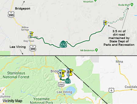 From Route 395 south of Bridgeport to Bodie State Historic Park.
 Post 1964 Signage History
In 1970, Chapter 1473 defined Route 270 as “Route 395 south of Bridgeport to Bodie State Historic Park.”
 Status
 From 9.9 mi E of US 395 to Bodie State Historic Park. Mono
County and the State Department of Parks and Recreation entered into an
agreement on 12/6/1983 whereby the Department of Parks and Recreation is
responsible for maintaining, developing, repairing, improving,
constructing, and reconstructing this 3.5 mi segment of Route 270. The
Department of Parks and Recreation has indicated they would like to keep
the existing dirt road so the tourist can have the true Bodie experience
by travelling the last 3.5 mi on a dirt road. District 9 recommended that
this stretch be deleted from the state highway system.
From 9.9 mi E of US 395 to Bodie State Historic Park. Mono
County and the State Department of Parks and Recreation entered into an
agreement on 12/6/1983 whereby the Department of Parks and Recreation is
responsible for maintaining, developing, repairing, improving,
constructing, and reconstructing this 3.5 mi segment of Route 270. The
Department of Parks and Recreation has indicated they would like to keep
the existing dirt road so the tourist can have the true Bodie experience
by travelling the last 3.5 mi on a dirt road. District 9 recommended that
this stretch be deleted from the state highway system.
The 2013 Traversable Highways Report notes that the California Department of Parks and Recreation (DPR) maintains Route 270 from 9.9 miles east of Route 395 to Bodie State Park. DPR is responsible for maintaining, developing, repairing, improving, constructing, and reconstructing this 3.5 miles of road. This 3.5 miles cannot be accepted into the SHS until brought up to state highway standards.
In July 2017, Tom Fearer (Max Rockatansky) on AARoads noted that the dirt
segment of Bodie Road from the end of Route 270 to Bodie is in extra bad
shape. The wash boarding is very heavy and doesn't really clear up until
the gate of the park. Max also provided some more details on the history
of the route: All of Bodie Road shows as county maintained to NV3C at the
state line on the 1970 Map with the planned state highway alignment shown
on the 1975 State Highway Map. Between 1979 and 1981 CA 270 appears to
have been completed for the first 10 of 13 adopted miles to Bodie. Max
also noted that it appears the recommendation to delete the dirt portion
from the state highway system occurred, as there is an "END" sign where
the asphalt ends. Bodie itself it was established as a small mining camp
in 1859 after the discovery of gold in the Bodie Hills. Large deposits
were found in 1876 and 1878 which led to a population swell to at least
5,000 people in Bodie by 1879. The Bodie and Benton Railroad was a 32 mile
line built from Mono Mills north to Bodie to transport lumber. The line
followed the eastern shore of Mono Lake, crossed what is now CA 167, and
ascended what is now Cottonwood Canyon Road to Bodie. The population
decline in Bodie started in the 1880s and progressed through the early
20th century to 1940 when the Census on only 40 residents left in the
town. The Bodie and Benton Railroad was dismantled in 1918 when there
might have been just a little over 100 people left in Bodie. Post Office
Service stopped in Bodie in 1942 and there was only three people recorded
living in the town by 1943. The town of Bodie was made into a State Park
in 1962 when a little under 200 of the claimed original 2,000 buildings
were left standings. The bypass route of Bodie which goes to the State
Park parking lot is a modern construction given the higher grade gravel
that is present on it. To reach Aurora in Nevada you would need to enter
Bodie via Main Street and follow it out of town where Bodie Road would
resume. Bodie Road continues another 9-10 miles to NV 3C which is about
another 3-4 miles away from the Aurora Ghost town. NV 3C continues north
to NV 208 south of Yerington which would have been NV 3 prior to the state
highway renumbering. NV 3C isn't part of the state highway system today
and never appears to have been maintained beyond the county level.
According to what I was told last year you'll need a high clearance
vehicle to get through NV 3C to NV 208 given that that a bridge failed
just over the Nevada State Line. Bodie-Masonic Road traverses north out of
Bodie to the ghost town called Masonic. From Masonic, Route 182 can be
reached via Masonic Road by traveling southwest. Aside from that there is
a couple more mining ghost town sites in the general area around the Bodie
Hills, but nothing that appears to have been much more than a collection
of shacks.
(Source (with great images): Tom Fearer (Max Rockatansky) on AARoads, July 2017)
 Other WWW Links
 Statistics
Overall statistics for Route 270:
 Pre-1964 Legislative Route
In 1959, Chapter 1062 defined LRN 270 as “Terminal Island to [LRN 173]”. This was the proposed "Industrial" Freeway, Route 47 from Terminal Island to I-10.
© 1996-2020 Daniel P. Faigin.
Maintained by: Daniel P. Faigin
<webmaster@cahighways.org>.
 Route 269
 Route 271