
 California Highways:
Click here for a key to the symbols used. An explanation of acronyms may be found at the bottom of the page.
 Routing
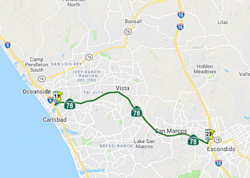 From Route 5 near Oceanside to Route 15 near Escondido.
 Post 1964 Signage History
In 1963, this segment was defined as the route from “Route 5 near Oceanside to Route 395 near Escondido.”
 Pre 1964 Signage History
In 1934, Route 78 was signed along the route from Jct. US 101 near Oceanside to Jct. US 99 near Kane Springs, via Ramona. This was once routed along Vista Way, Santa Fe, and Mission Road to Escondido. It was LRN 196, which was originally defined to run from LRN 2 (US 101) to LRN 77 in Vista. LRN 197 was defined to run from LRN 77 in Escondido, so it appears as if the portion between Vista and Escondido was part of the LRN 77 routing. However, in 1947 the definition of LRN 196 was changed to terminate simply at Vista, and in 1951 it was changed to terminate at LRN 77 near Escondido (US 395), making it likely that in 1951, the route between Vista and Escondido was transferred (with no change to LRN 77) from LRN 77 to LRN 196.
By 1935, Division of Highways County Maps showed Route 78 following LRN 196 on Vista Way between US 101/LRN 2 Oceanside east to US 395/LRN 77 in
Vista. Route 78 multiplexed US 395/LRN 77 east from Vista to
Escondido via Santa Fe Avenue, Mission Road and what is now Mission
Avenue. Within Escondido, Route 78 and US 395 multiplexed via
Broadway where Route 78 split east onto LRN 197 via Grand Avenue.
(Source: Gribblenation Blog (Tom Fearer), “California State Route 78”, April 2022)
In the late 1940s, US 395/LRN 77 was modernized between San Diego and
Riverside. The new alignment of US 395/LRN 77 provided a direct
north/south routing between San Diego and Riverside by way of
Escondido. The new alignment of US 395/LRN 77 removed the multiplex
of Route 78 between Vista and Escondido. As a result, in 1947 the
legislature altered the definition of LRN 196 as terminating at Vista
instead of LRN 77. In 1950, the new 18.3-mile alignment of US 395/LRN 77
opened, routed directly north from Miramar towards Temecula via
Escondido. The new alignment of US 395 left Route 78 alone aligned
over what had been LRN 77 between Vista-Escondido. For a brief
period, the former LRN 77 was not in the state highway system. In 1951,
the legislature extended LRN 196 from Vista to LRN 77 in Escondido.
This measure brought Route 78 between Vista-Escondido back under state
maintenance as part of LRN 196.
(Source: Gribblenation Blog (Tom Fearer), “California State Route 78”, April 2022)
 In 1951, a proposed route was floated for Route 78
between Oceanside and Vista. The initial project would be a four-lane
divided expressway. A separated intersection would be provided with US 101
(eventual I-5) in Oceanside. The route would be improved so that traffic
could go faster than 25 mph, and it would be raised to prevent flooding.
The section of highway between Vista and Escondido that was part of the
state highway system prior to the relocation of US 395 in 1948 has been
restored to state highway status and will be an easterly extension of
Route 78.
In 1951, a proposed route was floated for Route 78
between Oceanside and Vista. The initial project would be a four-lane
divided expressway. A separated intersection would be provided with US 101
(eventual I-5) in Oceanside. The route would be improved so that traffic
could go faster than 25 mph, and it would be raised to prevent flooding.
The section of highway between Vista and Escondido that was part of the
state highway system prior to the relocation of US 395 in 1948 has been
restored to state highway status and will be an easterly extension of
Route 78.
(Source: Times Advocate, 9/8/1951 via Joel Windmiller, 2/19/2023)
During 1959, the entire planned corridor of the Route 78/LRN 196 freeway
between Oceanside and Escondido was added to the Freeways and Expressway
System. Construction funding was made available during 1960. Construction
continued through the 1960s. Ultimately Route 78 west of Vista to I-5 in
Oceanside was constructed to freeway standards from 1967 through 1973.
During 1968, much of what had been Route 78 on Mission Road and Santa Fe
Avenue in the Escondido-Vista corridor was designated as San Diego County Sign Route S14.
(Source: Gribblenation Blog (Tom Fearer), “California State Route 78”, April 2022)
 Status
I-5/Route 78 Interchange (11-SD-078 0.0)
 The SAFETEA-LU act, enacted in August 2005 as the reauthorization of TEA-21, provided the
following expenditures on or near this route: High Priority Project
#3206: I-5 and Route 78 Interchange Improvements. $4,000,000.
The SAFETEA-LU act, enacted in August 2005 as the reauthorization of TEA-21, provided the
following expenditures on or near this route: High Priority Project
#3206: I-5 and Route 78 Interchange Improvements. $4,000,000.
In June 2015, it was reported that Caltrans is in the
process of rebuilding the I-5/Route 78 interchange (11-SD-078 0.0) that
spills traffic into a residential neighborhood. Caltrans first shared
information on proposed interchange improvements in January 2015, and
followed up with additional community briefings since then. This was
reolated to a number of planned I-5 corridor improvements, and the
necessity to upgrade both ends of Route 78 before future work on I-5
begins. The roadway improvements would be designed to ease expected
traffic flow for 30 years out. There was a specific community concern
about flyovers; the community wanted flyovers to be eliminated as an idea.
Caltrans indicated that a flyover would be studied for traffic, cost and
impact on neighborhoods, along with other alternatives. However, they
appreciated community feedback, and it provided Caltrans great ideas,
including consideration of a roundabout and bike lane. In addition to
objections to noise and pollution, residents expressed concern over the
lack of progress in Buena Vista Lagoon restoration, which the interchange
will cross. Another big concern of residents and city council members was
the speed of traffic that exits the interchange and barrels through a
South Oceanside neighborhood.
(Source: The Coast News, 6/10/2015)
In January 2022, it was reported that the congested
interchange between state Route 78 and I-5 in North County could be
upgraded with federal infrastructure money. The junction connects two
heavily traveled freeways, but instead of an uninterrupted transition,
vehicles in the westbound lanes of state Route 78 must wait at a stoplight
to turn south to get onto I-5. This leads to back-ups in the westbound
lanes causing delays as long as 15 minutes during rush hour and increasing
the risk of accidents. To modernize the interchange, officials plan to
build a flyover overpass that would route cars over existing lanes,
according to the San Diego Association of Governments. It would replace
the traffic light and allow vehicles on Route 78 to merge seamlessly onto
I-5 without slowing or stopping. The $1.2 trillion federal Infrastructure
Investment and Jobs Act, passed in November 2021, authorizes funding to
modernize roads, bridges, rail, ports, water systems and broadband lines.
California’s share includes $29.5 billion for roads and bridges,
which officials hope to tap for the interchange. The federal Department of
Transportation will provide $4.8 billion to California immediately and
CalTrans will administer the money within the state. The North County
interchange project requires two or more years for environmental review
and engineering plans. After that construction of the new interchange
could be completed within about 18 months.
(Source: San Diego Union Tribune, 1/24/2022)
There are plans to construct an eastbound auxiliary lane in Oceanside from the El Camino Real Overcrossing (~ SD 1.483) to east of El Camino Real Overcrossing. July 2005 CTC Agenda.
In May 2012, the Oceanside Planning Commission approved plans to construct an interchange between Route 78 and Rancho Del Oro Drive (~ SD 2.367). The interchange would be for westbound traffic only. Dropped from the plan was a proposal to connect segments of Melrose Drive south of Route 76 to create a link to the highway.
In January 2007, the CTC considered relinquishment of right of way in the City of Vista, at Melrose Drive, consisting of reconstructed and relocated city streets. The City, by freeway agreement dated February 13, 1996, agreed to accept title upon relinquishment by the State. (~ SD 6.01)
San Marcos Aux Lane Adjustments (11-SD-78 14.7/15.3)
In October 2022, the CTC approved the following
pre-construction phase allocation: $2,396,000. 11-SD-78 14.7/15.3. PPNO
11-1476; ProjID 1122000231; EA 43163. Route 78 In San Marcos, from 0.3
mile west to 0.3 mile east of Mission Road. Modify auxiliary lanes.
Allocation: FY25-26 PS&E $1,546,000; R/W Sup $850,000.
(Source: October 2022 CTC Agenda, Agenda Item 2.5b.(2a) #16)
In January 2024, the CTC revised the following project
in the 2022 SHOPP: #29. 11-SD-78 14.7/15.3. PPNO 11-1476; ProjID
1122000231; EA 43163. Route 78 In San Marcos, from 0.3 mile west to 0.3
mile east of Mission Road. Modify auxiliary lanes. This is a
Construction Manager/General Contractor (CMGC) project. Note:
Update description to change the project delivery type from
design-bid-build to CMGC to save project time and reduce construction
risks. No allocation changes.
(Source: January 2024 CTC Agenda, Agenda Item 2.1d #29)
I-15/Route 78 Managed Lanes Direct Connectors Project (~ SD R16.337)
 There are early plans to expand this route in Escondido
(~ SD R16.337). The plans could result in either two car-pool lanes or two
toll lanes from Oceanside to Escondido by 2020. If car-pool lanes are
picked, they would provide designated space for buses, car pools, van
pools and solo drivers willing to pay a fee. Toll lanes would be open to
everyone…. for a fee.The study should be completed in Spring 2012.
In 2009, Route 78 handled an average of between 120,000 and 160,000
weekday vehicle trips, according to the California Department of
Transportation. Route 78 was built in the 1970s and widened from four
lanes to six in 1993.
There are early plans to expand this route in Escondido
(~ SD R16.337). The plans could result in either two car-pool lanes or two
toll lanes from Oceanside to Escondido by 2020. If car-pool lanes are
picked, they would provide designated space for buses, car pools, van
pools and solo drivers willing to pay a fee. Toll lanes would be open to
everyone…. for a fee.The study should be completed in Spring 2012.
In 2009, Route 78 handled an average of between 120,000 and 160,000
weekday vehicle trips, according to the California Department of
Transportation. Route 78 was built in the 1970s and widened from four
lanes to six in 1993.
(Image Source: Rte 78 Corridor Project Page)
In October 2020, it was reported that SANDAG was
holding a virtual meeting to get public input on improvements to the I-15
and state Route 78 interchange. These are still five years away and will
depend on funding. A study to evaluate plans to improve Route 78 was
completed in 2012 and some construction improvements just west of the
I-15/SR 78 interchange were implemented. SANDAG and Caltrans have proposed
additional improvements to this corridor, including the I-15/Route 78
Managed Lanes Direct Connectors Project, the I-5/Route 78 Interchange
Project, the Route 78 Managed Lanes Project, and operational improvements
along Route 78. Other long-term projects include future double tracking
and express services for the SPRINTER and the construction of additional
segments of the Inland Rail Trail Bike Path. First up is the I-15/Route 78
Managed Lanes Direct Connectors Project, for which environmental studies
are starting. Specifically, the project will improve connectivity by:
(Source: Rte 78 Corridor Project Page)
 Naming
This segment has often been called the "Anza Freeway".
 It is officially named the "Ronald Packard Parkway". Ronald C. Packard was congressman from the 48th Congressional District
beginning in 1982, serving as the chairperson of the North County Transit
District in San Diego County. Ronald Packard was instrumental in obtaining
funding for the San Diego Trolley and Coaster Rail systems and receiving
needed supplemental funding for numerous highway interchanges throughout
San Diego County. He was the primary person responsible for the
improvements made to the State Highway Routes 76 and 78. Named by Assembly
Concurrent Resolution 165, Chapter 124, September 5, 2000.
It is officially named the "Ronald Packard Parkway". Ronald C. Packard was congressman from the 48th Congressional District
beginning in 1982, serving as the chairperson of the North County Transit
District in San Diego County. Ronald Packard was instrumental in obtaining
funding for the San Diego Trolley and Coaster Rail systems and receiving
needed supplemental funding for numerous highway interchanges throughout
San Diego County. He was the primary person responsible for the
improvements made to the State Highway Routes 76 and 78. Named by Assembly
Concurrent Resolution 165, Chapter 124, September 5, 2000.
(Image source: Congress.Gov)
 Named Structures
The Twin Oaks Valley Road Bridge (Bridge 57-1033, SD 012.91) in the City of San Marcos, San Diego County is officially named the "Vicente "Vince" Andrade Memorial Bridge". Vicente "Vince" Andrade, originally from Winslow, Arizona was a powerful force both in the City of San Marcos and as a voice for North San Diego County's Latino community. In May 1998, he received the Making A Difference Award, lauding Mr. Andrade's leadership in founding El Grupo Sin Nombre, an umbrella organization aimed at giving 37 Latino groups a unified voice on political and social issues in North San Diego County. He served as Chairperson of the Board of Directors for North County Health Services, President of the Hispanic Advisory Council at California State University, San Marcos, and Chairperson of the Latino Coalition for Education. In 1996, after a three-year term on the planning commission, Vince Andrade was elected to the San Marcos City Council where he served with distinction and represented the city as a SANDAG board member and was instrumental in securing additional funds for construction of the Twin Oaks Valley Road interchange improvements. This outstanding community leader died on January 23, 1999 after a five year courageous battle against recurring cancer. Named by Senate Concurrent Resolution 9, Chaptered April 30, 2001, Resolution Chapter 46.
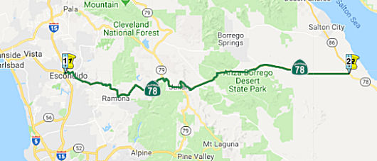 From Route 15 near Escondido to Route 86 passing near Ramona, Santa Ysabel, and
Julian.
From Route 15 near Escondido to Route 86 passing near Ramona, Santa Ysabel, and
Julian.
Post 1964 Signage HistoryAs defined in 1963, this segment was the route from “Route 395 near Escondido to Route 86 near Kane Springs passing near Romona and Santa Ysabel and via Julian.”
In 1963, Chapter 1698 appears to have corrected a spelling error, changing "Romona" to "Ramona"
In 1969, Chapter 294 changed “Route 395” to “Route 15”.
In 1972, Chapter 1216 simplified the routing to be “Route 15 near
Escondido to Route 86 near Kane Springs passing near
Ramona, and Santa Ysabel, and via
Julian.”
Pre 1964 Signage HistoryThe history of this segment dates back to the Banner Toll Road, which was
constructed around 1870 between the towns of Julian and Banner. By
1874 the Banner Toll Road was purchased by San Diego County and made
accessible to the public. During the early 1920s the existing Julian
Road and Santa Ysabel Grade were reconstructed by San Diego County from
Ramona east to Julian. By 1925 San Diego County had constructed a new road
from Banner east to LRN 26 (US 99, now Route 86) near Kane Springs.
(Source: Gribblenation Blog (Tom Fearer), “California State Route 78”, April 2022)
In 1934, Route 78 was signed along the route from Jct. US 101 near Oceanside to Jct. US 99 near Kane Springs, via Ramona. It was LRN 197 between Escondido and Ramona (junction Route 67). It was LRN 198 between Ramona and near Kane Springs and the junction with US 99 (LRN 26; now Route 86). Both LRN 197 and LRN 198 were defined in 1933.
By 1935, Route 78 and US 395 multiplexed within Escondido via Broadway
where Route 78 split east onto LRN 197 via Grand Avenue. From
Escondido Route 78 followed LRN 197 east via San Pasqual Valley Road and
Pine Street to LRN 198 in Ramona. Route 78/LRN 198 from Ramona
followed Julian Road east to Santa Ysabel where it picked up a multiplex
of Route 79 southbound. Route 78/Route 79 followed Julian Road east
from Santa Ysabel to Main Street in the community of Julian. From
Julian Route 78/LRN 198 followed Banner Grade east to the Imperial County
Line. Within Imperial County, Route 78 followed LRN 198 to a
terminus at US 99/LRN 26 near Kane Springs.
(Source: Gribblenation Blog (Tom Fearer), “California State Route 78”, April 2022)
The portion of the Rout between former Route 79 and Route 86 was part of the planned Imperial
Highway. The name "Imperial" refers to the Imperial Valley, which
took its name from the Imperial Land Co., a subsidiary of the California
Development Company charged with reclaiming the water-starved but arable
land east of San Diego for agricultural purposes in the early 1900s. The
company began building canals in 1900, diverting water from the Colorado
River for irrigation, and forming the Salton Sea in the process. The Los
Angeles area wanted to patch together a superhighway that would stretch
from the Pacific all the way to Brawley in the Imperial Valley, a distance
of 215 miles; the route was later extended a few miles farther south to El
Centro. The most route roughly followed the old Butterfield Stage overland
route, established in 1858: across the desert (Route 78) and along
today’s Route 79 to Temecula, where it headed on to Corona via Lake
Elsinore and Temescal Canyon (Route 71, later I-15). There the road turned
left down the Santa Ana Canyon on its way to Yorba Linda (present-day
Route 91) and La Habra (present-day Route 90), then across Los Angeles
County to meet the sea at El Segundo (as Imperial Highway, although it is
paralleled by I-105). The extension to Brawley was along Route 86 The
early Imperial Highway plans involved connecting a patchwork assortment of
roads of varying length and quality. In 1912, a group of Los Angeles
boosters informally known as the Committee of One Hundred, working with
Los Angeles, San Bernardino, Orange, Riverside and Imperial counties,
settled on a route along the edge of the inland Salton Sea that completely
bypassed San Diego County, from which Imperial County had been split off
in 1907. The Los Angeles section of road would be mostly a straight shot
from LAX to Anaheim, where the proposed road would dip south diagonally
before eventually reaching the Imperial Valley. By the 1920s, the efficacy
of the Imperial Highway concept had become apparent, and a new and more
forceful private group, the Imperial Highway Association, was formed in
1929 to encourage the regions involved to mount a fully cooperative
effort, including working closely with San Diego County, to get the job
done. The association adopted an official route for a more streamlined,
uniform highway in 1931 that ran slightly west of the earlier Salton Sea
route. The improved roadway, now referred to informally as “the
Cannon Ball Road,” would eliminate tight right angle turns that
slowed trucks, smooth and widen the various roadways involved, and have
new bridges where necessary. A major section in Yorba Linda was completed
in 1937. Two-lane portions of the highway through Inglewood had to be
expanded to four. A bridge over the Los Angeles River, completed in
1951, eliminated a crucial bottleneck; it replaced an old one that
collapsed in 1948. The final section of the Imperial Highway as envisioned
by the association was completed, and it was dedicated a scenic highway in
a ceremony on the Imperial-San Diego county border in December 1961. Of
its 220 total miles, 77 were county roads, with the rest being state
highways. The cost to complete the project was estimated at $16 million
(about $138 million in 2020 dollars). In 1965, Caltrans planned a new
freeway along the path of Imperial Highway, from LAX to Norwalk. It opened
in 1993 as I-105, though Imperial Highway itself remained in place, if
somewhat less crucial than it once was. Through Orange County, Imperial
Highway was Route 90. Major chunks of the roadway through Riverside and
San Diego counties were subsumed by newer freeways and highways over the
years. The 41-mile Los Angeles stretch, which passes through El Segundo,
Hawthorne, Inglewood, South Los Angeles, Lynwood, South Gate, Downey,
Norwalk, Santa Fe Springs and La Mirada, retains the original Imperial
Highway name, as does a section of Route 86 in El Centro (also known as
Imperial Avenue).
(Source: Daily Breeze, “South Bay History: Imperial Highway once figured as part of a superhighway plan”, 3/29/2021; Orange County History “The Imperial Highway”, 2011)
StatusEscondido Reconstruction (North Broadway (SD N17.705) and Flora Vista Street (SD R21.298))
 In January 2021, it was reported that Cal Trans was
starting construction on a $19 million multimodal project to upgrade about
five miles of Route 78 between North Broadway (SD N17.705) and Flora Vista
Street (SD R21.298) in Escondido. Initial work will improve curb ramps for
pedestrian access in accordance with the Americans with Disabilities Act.
Other work will include vehicle to infrastructure (V2I) traffic signal
upgrades, ITS upgrades and a Class III bike route. Subsequent construction
will include removal and replacement of the pavement, high visibility
striping, utility upgrades, and a shared bike lane. This project is
expected to be completed in Fall 2021. The $19 million project is funded
through the State Highway Operation and Protection Program (SHOPP).
In January 2021, it was reported that Cal Trans was
starting construction on a $19 million multimodal project to upgrade about
five miles of Route 78 between North Broadway (SD N17.705) and Flora Vista
Street (SD R21.298) in Escondido. Initial work will improve curb ramps for
pedestrian access in accordance with the Americans with Disabilities Act.
Other work will include vehicle to infrastructure (V2I) traffic signal
upgrades, ITS upgrades and a Class III bike route. Subsequent construction
will include removal and replacement of the pavement, high visibility
striping, utility upgrades, and a shared bike lane. This project is
expected to be completed in Fall 2021. The $19 million project is funded
through the State Highway Operation and Protection Program (SHOPP).
(Source: Escondido Times Advocate, 1/28/2021)
In February 2021, more details were provided on this
project. The project begins at Route 78 & Broadway, follows Broadway,
down Washington, hangs a right on Ash Street and becomes San Pasqual
Valley when it gets into the County, ending at Flora Vista, just after
Summit Drive. Work will include repaving Route 78, reconstructing curb
ramps for the Americans With Disabilities Act (ADA) compliance, vehicle to
infrastructure (V2I) traffic signal upgrades, ITS (Intelligent
Transportation System) upgrades and a Class III bike route. This is the
first rebuild of the route in 15 years. For this project, all of the
asphalt will be removed and replaced with a large stone matrix, similar to
what is used on airports, in order to get more longevity in the pavement.
Specifically, Caltrans will remove 6/10th of the
asphalt, about 8 inches or so. The new asphalt will be of “airport
quality”—this means a road of large stone matrix that is
typically usually used for heavier vehicles such as an airplane. The
project will be reconstructing eighty-three curb ramps to make them ADA
compliant, and doing signal improvements at twelve intersections along the
route. Safety improvements include upgrading guardrails and updating the
traffic striping, including the addition of ‘sharrows’. Tech
updates and improvements include installation of fiber optic cables and
implementing some V2I (Vehicle-to-Infrastructure) modules that talk to
smart vehicles, V2I sensors are used in intelligent transportation systems
(ITS) to capture data and issue drivers with real-time advisories about
such things as traffic congestions, construction sites, road conditions,
and parking zones. As an example, Teslas have an app that can be used that
will tell the driver what speed to drive at if they want to catch all the
greens along the route. Plans are to complete the project by November
2021.
(Source: Escondido Times-Advocate, 2/11/2021)
In October 2012, the CTC authorized relinquishment of right of way in the county of San Diego along Route 78 at Haverford Road near Ramona, consisting of collateral facilities. (~ SD 33.781)
In May 2021, it was reported that Caltrans is proposing to modify the
striping on Route 78/Main Street between 10th Street (~ SD 35.519) and 8th
Street (~ SD 35.735) in Ramona to create 41 parallel parking spaces in
previously designated No Parking areas, according to the site.
Construction could begin in summer 2021 and is expected to take a few
weeks to complete. The proposal includes: (1) Two (12-foot) lanes in each
direction between Ninth and 10th streets. One (12-foot) and one (11-foot)
lane in each direction between Eighth and Ninth streets. (2) Shoulder
width 8-foot on both sides. (3) No median two-way turning lane between
Ninth and 10th streets. (4) Parallel parking spaces for 21 vehicles on the
westbound side and 20 on the eastbound side.
(Source: $Ramona Sentinel, 5/12/2021)
Naming The segment between Route 67 and Third
Street (~ SD 35.535 to SD 36.296) in Ramona is officially named the "Ramon
Ojeda Memorial Highway". It was named in memory of Army Specialist
Ramon Ojeda, who was killed in action in Baghdad, Iraq on May 1, 2004, at
the age of 22, when his convoy was attacked by terrorists. Specialist
Ojeda attended school in Ramona, California, and was survived by his wife,
Lesliee, who was serving in the United States Army in Iraq, and by his
14-month-old son, Angel. He wrestled at Ramona High School and had a "can
do" spirit, and a remarkable ability to disarm and cheer up others with
his levity. Specialist Ojeda joined the United States Army and was
assigned to the Army's 25th Infantry Division, and was the
first Ramona resident killed in action in Iraq. Named by Assembly
Concurrent Resolution (ACR) 47, Resolution Chapter 100, on 8/16/2006.
The segment between Route 67 and Third
Street (~ SD 35.535 to SD 36.296) in Ramona is officially named the "Ramon
Ojeda Memorial Highway". It was named in memory of Army Specialist
Ramon Ojeda, who was killed in action in Baghdad, Iraq on May 1, 2004, at
the age of 22, when his convoy was attacked by terrorists. Specialist
Ojeda attended school in Ramona, California, and was survived by his wife,
Lesliee, who was serving in the United States Army in Iraq, and by his
14-month-old son, Angel. He wrestled at Ramona High School and had a "can
do" spirit, and a remarkable ability to disarm and cheer up others with
his levity. Specialist Ojeda joined the United States Army and was
assigned to the Army's 25th Infantry Division, and was the
first Ramona resident killed in action in Iraq. Named by Assembly
Concurrent Resolution (ACR) 47, Resolution Chapter 100, on 8/16/2006.
(Image source: Find a Grave, LA Times)
 The portion of Rout 78 from the intersection with Route 79 in Santa Ysabel to the intersection
with Route 79 in Julian (~ 78 SD 51.126 to 78 SD 58.11) as well as Route 79 from Julian to the intersection with Engineers Road in Cuyamaca in San
Diego County (~ 79 SD 12.139 to 79 SD 20.198) is named the Firefighter
Steven Rucker Memorial Highway. It was named in memory of
Firefighter Steven Rucker of Novato, California. In late October 2003,
Southern California experienced several devastating wildfires that
exceeded the devastation of any fires in the past century. In San Diego
County alone 400,000 acres burned, 2,600 homes where destroyed, and 17
lives were lost. Dedicated firefighters from across California and
nationwide responded to the urgent call for assistance and put their lives
and personal safety at risk to save the lives and property of the
residents of San Diego County. Additionally, members of the Armed Forces
courageously met their country's call to duty, providing valuable
firefighting assets and assistance to California's emergency response
efforts in keeping with the finest traditions of United States military
service. Firefighters displayed courage and uncommon bravery in working
the fire lines for long hours and with little rest, often while their own
homes and families were in jeopardy elsewhere, and many of these
firefighters lost their own homes to the fires while defending the lives
and property of others. Through the tireless and heroic efforts of
California's firefighters, volunteers, and members of the community, the
historic town of Julian was ultimately saved from destruction by the
wildfires. One of these firefighters, Steven Rucker of Novato, California
gave the ultimate sacrifice and lost his life in San Diego County on
October 29th, 2003 fighting the advancing fire line as it threatened the
town of Julian and neighboring mountain communities. Named by Senate
Concurrent Resolution 53, July 8, 2004, Chapter 114.
The portion of Rout 78 from the intersection with Route 79 in Santa Ysabel to the intersection
with Route 79 in Julian (~ 78 SD 51.126 to 78 SD 58.11) as well as Route 79 from Julian to the intersection with Engineers Road in Cuyamaca in San
Diego County (~ 79 SD 12.139 to 79 SD 20.198) is named the Firefighter
Steven Rucker Memorial Highway. It was named in memory of
Firefighter Steven Rucker of Novato, California. In late October 2003,
Southern California experienced several devastating wildfires that
exceeded the devastation of any fires in the past century. In San Diego
County alone 400,000 acres burned, 2,600 homes where destroyed, and 17
lives were lost. Dedicated firefighters from across California and
nationwide responded to the urgent call for assistance and put their lives
and personal safety at risk to save the lives and property of the
residents of San Diego County. Additionally, members of the Armed Forces
courageously met their country's call to duty, providing valuable
firefighting assets and assistance to California's emergency response
efforts in keeping with the finest traditions of United States military
service. Firefighters displayed courage and uncommon bravery in working
the fire lines for long hours and with little rest, often while their own
homes and families were in jeopardy elsewhere, and many of these
firefighters lost their own homes to the fires while defending the lives
and property of others. Through the tireless and heroic efforts of
California's firefighters, volunteers, and members of the community, the
historic town of Julian was ultimately saved from destruction by the
wildfires. One of these firefighters, Steven Rucker of Novato, California
gave the ultimate sacrifice and lost his life in San Diego County on
October 29th, 2003 fighting the advancing fire line as it threatened the
town of Julian and neighboring mountain communities. Named by Senate
Concurrent Resolution 53, July 8, 2004, Chapter 114.
(Image source: Western Sojourns, Find a Grave)
 Scenic Route
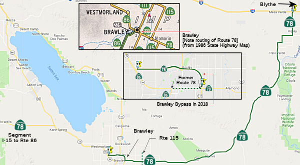 From Route 86 near Brawley to Route 10 near Blythe.
Note: Upon relinquishment of Route 86 in Brawley, the portion of Route 86 from 0.5 mile south of Fredricks Road to the north junction of Route 78 shall be redesignated as a part of Route 78.
Post 1964 Signage HistoryAs defined in 1963, this segment was:
Route 86 near Brawley to Route 10 near Blythe.
Notwithstanding the provisions of Section 89 of Chapter 1062, Statutes of 1959, the department shall proceed with the construction of the unconstructed portion of said route described in subdivision (c) between the easterly junction of Route 115 and the Imperial-Riverside county line with the lowest practical cost for a hard surfaced road and as an interim project pending the later construction of the route to proper limited access standards; provided, that prior thereto the County of Imperial enters into a co-operative agreement with the department wherein the county agrees to maintain the road between the easterly junction of Route 115 and the Imperial-Riverside county line until a limited access highway is constructed by the department between said points. Upon the completion of construction of said interim road, and pursuant to said agreement, the county shall assume jurisdiction and all responsibilities of maintenance for the period above provided. The road shall be known and designated as the "Ben Hulse Highway."
In 1965, Chapter 1371 seems to have just changed "co-operative" to "cooperative".
In 1968, Chapter 281 removed the following text about county maintenance: "; provided, that prior thereto the County of Imperial enters into a co-operative agreement with the department wherein the county agrees to maintain the road between the easterly junction of Route 115 and the Imperial-Riverside county line until a limited access highway is constructed by the department between said points. Upon the completion of construction of said interim road, and pursuant to said agreement, the county shall assume jurisdiction and all responsibilities of maintenance for the period above provided."
In 1976, Chapter 1354 removed all conditions.
In 2013, Chapter 525 (SB 788, 10/9/13) permitted relinquishment of Route 86 in Brawley, and added the language "(d) Following the relinquishments authorized in subdivision (b), the portion of Route 86 from 0.5 mile south of Fredricks Road to the north junction of Route 78 shall be redesignated as a part of Route 78."
Pre 1964 Signage HistoryThe small portion of this route within Brawley (from Route 86 to Route 115) was part of LRN 187, defined in 1933.
 The remainder of this segment was not part of the 1934
definition of signed Route 78. The portion from Palo Verde to Blythe was
LRN 146, defined in 1933. The remainder was a proposed county route
between Brawley and Palo Verde. It was constructed only between Palo Verde
and Blythe. With the advent of the 1934 signage, the segment from Palo
Verde to the Calfornia/Nevada border was signed as Route 195 (which
continued to the California/Nevada border along LRN 146). After US 95 was
signed in 1940, the portion N of Blythe to the Calfornia/Nevada border was
signed as US 95, and the portion S of Blythe to Palo Verde, although part
of LRN 146, was apparently unsigned. The portion between Brawley and Palo
Verde was added to LRN 146 in 1959, although as it was constructed, it was
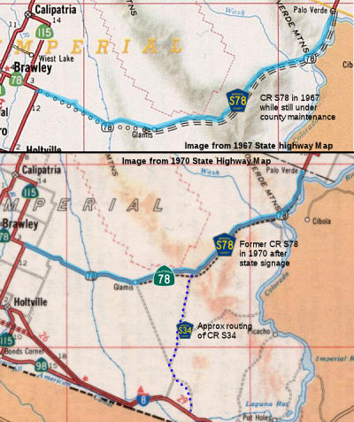
signed as a county route. A 1967 map shows the routing between Midway Well
and Route 115 as County Sign Route S78, with Route 78 signed with Route 115 between the
Brawley area and US 80.
The remainder of this segment was not part of the 1934
definition of signed Route 78. The portion from Palo Verde to Blythe was
LRN 146, defined in 1933. The remainder was a proposed county route
between Brawley and Palo Verde. It was constructed only between Palo Verde
and Blythe. With the advent of the 1934 signage, the segment from Palo
Verde to the Calfornia/Nevada border was signed as Route 195 (which
continued to the California/Nevada border along LRN 146). After US 95 was
signed in 1940, the portion N of Blythe to the Calfornia/Nevada border was
signed as US 95, and the portion S of Blythe to Palo Verde, although part
of LRN 146, was apparently unsigned. The portion between Brawley and Palo
Verde was added to LRN 146 in 1959, although as it was constructed, it was
signed as a county route. A 1967 map shows the routing between Midway Well
and Route 115 as County Sign Route S78, with Route 78 signed with Route 115 between the
Brawley area and US 80.
In 1939, the American Association of State Highway Officials Executive
Secretary proposed an alignment of US 95 south to Blythe. Subsequently, US 95 replaced Route 195 on LRN 146 from Blythe to the Nevada State
Line. The designation of Route 195 on LRN 146 south of Blythe to
Palo Verde was deleted, leaving it without a Sign State Route. Signage for
Route 195 was resassigned to what had been US 60/US 70 on LRN 64 in Box
Canyon east of Mecca. In 1959, the origin of LRN 146 was changed
from Palo Verde near the Imperial County Line to LRN 187 (Route 115) east
of Brawley. The newly extended segment of LRN 146 contained a
planned routing over the Algodones Dunes by way of Glamis and appears on
the 1960 Division of Highways Map. In late 1961, LRN 146 had a
formal route adoption from Glamis to towards Palo Verde by the California
Highway Commission. Much of LRN 146 in the Glamis-Palo Verde
corridor was adopted as expressway standard.
(Source: Gribblenation Blog (Tom Fearer), “California State Route 78”, April 2022)
By 1967, a county route -- Ben Hulse Highway -- had been completed
between Route 115 and Palo Verde; it was shown as "planned" Route 78, but
signed as County Sign Route S78. Only Route 78 from Glamis to Palo Verde had a determined
State Highway routing. The construction of a road to Glamis was
difficult to due to the presence of the Alogodones Dunes. The most
practical route from Brawley to Blythe was initially via Niland-Brawley
Road through the Chocolate Mountains. Within Riverside County
Niland-Brawley Road emerged onto the Bradshaw Trail that ended at LRN 146
several miles north or Palo Verde. Existing Niland-Brawley Road in the
Chocolate Mountains was sold to the Navy during February 1957 to fund
construction the Glamis Road. California State Senator Ben Hulse is
quoted in a Los Angeles Times article from the era predicting the Glamis
Road would become a State Highway. The road connecting Brawley to
Glamis opened on August 13, 1958. The opening of the new road to
Glamis saw it incorporated into the planned extension of LRN 146.
The completion of Ben Hulse Highway from Route 115 to existing Route 78
near Palo Verde occurred in 1964
(Source: Gribblenation Blog (Tom Fearer), “California State Route 78”, April 2022; rschen7754 via Wikipedia via Gribblenation (Wikipedia History))
StatusBrawley Bypass
It appears there are plans to convert at least part of this to freeway. The April 2003 CTC had on its agenda the route adoption of a Freeway location for Route 78, northwest of the City of Brawley, to Route 111, southwest of the City of Brawley, in Imperial County. [11-Imp-78 KP R14.6/R24.8 (PM R09.1/R15.4) and 11-Imp-111 KP R33.0/R39.7 (PM R20.5/R24.7)]. There was also an item related to a negative environment impact for the project.
The SAFETEA-LU act, enacted in August 2005 as the reauthorization of TEA-21, provided the following expenditures on or near this route:
In his 2006 Strategic Growth Plan, Governor Schwartzenegger proposed completing stages 2 and 3 of the Brawley Bypass. In November 2007, bids went out for construction of a 4-lane divided expressway and interchange on Route 78 near Brawley from 0.6 Km East of Hovley Road to 0.4 Km North of the Route 78/Route 111 Junction
2007 CMIA. The Brawley Bypass on Route 78 was submitted to the Corridor Mobility Improvement Account for funding ($46.1 million). It was not recommended for funding.
In February 2009, the CTC was noticed that Caltrans and the Imperial Valley Association of Governments (IVAG) recommended that Brawley Bypass projects programmed in the 2008 State Transportation Improvement Program (STIP) be reprogrammed as a corridor, with funding levels to be based on the state funds previously allocated by the California Transportation Commission (Commission) and available local and federal funds: (a) Route 78 Brawley Bypass — Stage 2 project (PPNO 0021F) (b) Route 78 Brawley Bypass — Route 86 to Route 111 project (PPNO 0021).
In February 2010, the CTC approved some funding changes regarding the Brawley Bypass. Specifically, they amended the project agreement to reprogram $1,909,000 of Federal Safe, Accountable, Flexible, Efficient Transportation Equity Act: A Legacy for Users (SAFETEA-LU) Border Infrastructure Program (BIP) funds to the right of way phase on the Brawley Bypass (Stage 3) project (PPNO 0021G) in Imperial County. The purpose was to fund right of way activities related to additional impacts to agricultural land within the project vicinity. It should be noted this is a long project; the schedule shows environmental started in March 1993, and project closeout is expected to finish in January 2013 (construction should finish in February 2012).
In May 2012, the CTC amended the the Trade Corridor Improvement Fund (TCIF) baseline agreement for Project No. 77 – Brawley Bypass (Route 78/Route 111 Expressway) – Stage 3 Project (PPNO 0021G) in Imperial County. The amendment revised the project schedule and split off a follow-up landscape mitigation project (PPNO 0021Y). The approved baseline schedule was been revised to update the end of construction and closeout phases. The original construction schedule was developed assuming minimal structural construction on the project. However, during the design phase, a bridge was added to allow for canal maintenance, triggering an extended construction period.
In December 2014, the CTC authorized relinquishment of right of way in the county of Imperial along realigned Route 78 between existing Route 86 (IMP R9.324) and New River (~ IMP R12.564) and along Route 86 between Fredericks Road and Gardner Road, consisting of a collateral facilities. The County, by controlled access highway agreements dated December 17, 1991 and May 6, 2003, agreed to accept title upon relinquishment by the State. The 90-day notice period expires December 1, 2014.
In October 2012, the CTC authorized relinquishment of right of way in the city of Brawley on Route 78 (Main Street) between existing Route 86 and realigned Route 111, consisting of superseded highway right of way (~ 11-Imp-78-PM 13.2/15.5).
In January 2012, the CTC authorized relinquishment of right of way in the city of Brawley along realigned Route 78 from Best Road (~ IMP R13.92) to Route 111 (~ IMP R15.464), consisting of collateral facilities.
In December 2011, the CTC authorized relinquishment of right of way in the county of Imperial along Route78 between Route 111 and the realigned 111, and along Route 111 between Mead Road and Route 78, consisting of superseded highway right of way and collateral facilities. (11-Imp-78-PM 15.0/15.7, 11-Imp-111-PM 20.5/22.2)
In May 2018, the CTC authorized relinquishment of right of way in the
city of Brawley (City) along Route 78, 0.1 mile west of its intersection
with Route 111, consisting of collateral facilities (11-Imp-78-PM
15.4/15.5). The City, by letter dated February 8, 2018 confirmed that the
City Council, at their November 21, 2017 meeting, agreed to waive the
90-day notice requirement and accept title upon relinquishment by the
State.
(Source: CTC Minutes, May 2018 Agenda Item 2.3c)
Naming The portion of this part of the route between the junction of Route 78 and Route 111 (formerly Route 86, changed by Senate Concurrent
Resolution 70, July 16, 2004, Chapter 121) upon its construction near
Brawley and Route 10 near Blythe (~ IMP 20.486 to RIV 15.629) is
officially designated the "Ben Hulse Highway". It was named by
Assembly Bill 2499, Chapter 1387 in 1961 (for LRN 146); the name was
transferred to Route 78 in 1963. California State Senator Ben Hulse served
the people of Imperial County from 1933 to 1958.
The portion of this part of the route between the junction of Route 78 and Route 111 (formerly Route 86, changed by Senate Concurrent
Resolution 70, July 16, 2004, Chapter 121) upon its construction near
Brawley and Route 10 near Blythe (~ IMP 20.486 to RIV 15.629) is
officially designated the "Ben Hulse Highway". It was named by
Assembly Bill 2499, Chapter 1387 in 1961 (for LRN 146); the name was
transferred to Route 78 in 1963. California State Senator Ben Hulse served
the people of Imperial County from 1933 to 1958.
(Image Source: East Side of the West, Imperial Unified School District)
 The portion of Route 78 "Brawley Bypass"
from Route 86 near Brawley to the Highline Canal east of Brawley, in the
County of Imperial (~ IMP 20.486 to IMP 027.28) is named the Victor V.
Veysey Expressway. It was named in honor of Victor Vincent Veysey,
who was born in Los Angeles in 1915, and earned degrees at the California
Institute of Technology and Harvard University. After 11 years of teaching
at the California Institute of Technology and Stanford University, he
moved to the County of Imperial to begin a career in farming. In 1955 he
was elected to the Brawley School District Board of Directors, and later
in 1960 was elected to the Imperial Valley College Board where he served
until 1962. From 1963 to 1971 he served in the California Assembly, as the
last resident of the County of Imperial to serve in the Legislature. He
was a Congressman in the United States House of Representatives from 1971
to 1975, representing the 38th and 43rd Districts of California. He then
went on to serve in President Ford's administration as the Assistant
Secretary of the Army for Civil Works until 1977, where he played a major
role in the negotiations that eventually led to the agreement on the
Panama Canal. Governor Deukmejian appointed Mr. Veysey to serve as the
California Secretary for Industrial Relations in 1983; and he went on to
serve as Director of the Industrial Relations Center and Lecturer in
Business Economics, at the California Institute of Technology. He passed
away on February 13, 2001, in Hemet, California. Named by Senate
Concurrent Resolution 70, July 16, 2004, Chapter 121.
The portion of Route 78 "Brawley Bypass"
from Route 86 near Brawley to the Highline Canal east of Brawley, in the
County of Imperial (~ IMP 20.486 to IMP 027.28) is named the Victor V.
Veysey Expressway. It was named in honor of Victor Vincent Veysey,
who was born in Los Angeles in 1915, and earned degrees at the California
Institute of Technology and Harvard University. After 11 years of teaching
at the California Institute of Technology and Stanford University, he
moved to the County of Imperial to begin a career in farming. In 1955 he
was elected to the Brawley School District Board of Directors, and later
in 1960 was elected to the Imperial Valley College Board where he served
until 1962. From 1963 to 1971 he served in the California Assembly, as the
last resident of the County of Imperial to serve in the Legislature. He
was a Congressman in the United States House of Representatives from 1971
to 1975, representing the 38th and 43rd Districts of California. He then
went on to serve in President Ford's administration as the Assistant
Secretary of the Army for Civil Works until 1977, where he played a major
role in the negotiations that eventually led to the agreement on the
Panama Canal. Governor Deukmejian appointed Mr. Veysey to serve as the
California Secretary for Industrial Relations in 1983; and he went on to
serve as Director of the Industrial Relations Center and Lecturer in
Business Economics, at the California Institute of Technology. He passed
away on February 13, 2001, in Hemet, California. Named by Senate
Concurrent Resolution 70, July 16, 2004, Chapter 121.
(Image source: AARoads, Wikipedia)
Named Structures The New River Bridge on the Route 78 Bypass (Bridge 58-0337, IMP R012.48) in Imperial County is
officially named the "Douglas B. Dunaway Memorial Bridge". This
structure was named in memory of Douglas Brian Dunaway, who was born in
Walsingham, England at Sculthorpe Air Base in 1959 to a military family
serving abroad, who enlisted in the United States Army in 1977, and who
was honorably discharged after four years of service. Upon discharge from
the Army, Mr. Dunaway attended Oregon State University and earned a
bachelor of science degree in civil engineering. Mr. Dunaway began his
career with the Office of Structures Construction of the Department of
Transportation in 1991. Mr. Dunaway was an exemplary employee who received
numerous awards, including three superior accomplishment awards
recognizing his ongoing efforts to deliver the highest quality product to
the customers of the department, and for delivering specialized training
and mentoring for staff. Mr. Dunaway gained the respect of supervisors,
management, and peers for his commitment to high professional standards,
and excelled as a mentor to all employees. Mr. Dunaway was one of the most
experienced structure representatives in District 11 of the Department of
Transportation, serving Imperial and San Diego Counties, and was named the
Structure Representative of the Year in 2008. Over his 19-year career, Mr.
Dunaway worked on some of the most complex structures throughout the
state, including structures on Route 5, Route 14, Route 15, Route 78,
Route 86, Route 94, and Route 905. Mr. Dunaway's passion was bridge
building and he volunteered for several assignments in Imperial County
over his career, where he enjoyed living and working. As a humanitarian,
Mr. Dunaway was an avid supporter of Feed the Children, Toys for Tots,
various battered women's shelters, and local shelters for the homeless.
Mr. Dunaway passed away unexpectedly on March 5, 2010, while working on
the Brawley Bypass as the structure representative, and is interred at the
Dallas Cemetery in Dallas, Oregon. Named by Senate Concurrent Resolution
(SCR) 116, Resolution Chapter 128, on 9/7/2010.
The New River Bridge on the Route 78 Bypass (Bridge 58-0337, IMP R012.48) in Imperial County is
officially named the "Douglas B. Dunaway Memorial Bridge". This
structure was named in memory of Douglas Brian Dunaway, who was born in
Walsingham, England at Sculthorpe Air Base in 1959 to a military family
serving abroad, who enlisted in the United States Army in 1977, and who
was honorably discharged after four years of service. Upon discharge from
the Army, Mr. Dunaway attended Oregon State University and earned a
bachelor of science degree in civil engineering. Mr. Dunaway began his
career with the Office of Structures Construction of the Department of
Transportation in 1991. Mr. Dunaway was an exemplary employee who received
numerous awards, including three superior accomplishment awards
recognizing his ongoing efforts to deliver the highest quality product to
the customers of the department, and for delivering specialized training
and mentoring for staff. Mr. Dunaway gained the respect of supervisors,
management, and peers for his commitment to high professional standards,
and excelled as a mentor to all employees. Mr. Dunaway was one of the most
experienced structure representatives in District 11 of the Department of
Transportation, serving Imperial and San Diego Counties, and was named the
Structure Representative of the Year in 2008. Over his 19-year career, Mr.
Dunaway worked on some of the most complex structures throughout the
state, including structures on Route 5, Route 14, Route 15, Route 78,
Route 86, Route 94, and Route 905. Mr. Dunaway's passion was bridge
building and he volunteered for several assignments in Imperial County
over his career, where he enjoyed living and working. As a humanitarian,
Mr. Dunaway was an avid supporter of Feed the Children, Toys for Tots,
various battered women's shelters, and local shelters for the homeless.
Mr. Dunaway passed away unexpectedly on March 5, 2010, while working on
the Brawley Bypass as the structure representative, and is interred at the
Dallas Cemetery in Dallas, Oregon. Named by Senate Concurrent Resolution
(SCR) 116, Resolution Chapter 128, on 9/7/2010.
(Image source: AAroads, Find a Grave)
 Exit Information
 Other WWW Links
 Freeway
[SHC 253.1] Entire route. Part (1) and the portion of part (2) from Route 15 to Escondido are constructed to freeway standards. Added to the Freeway and Expressway system in 1959.
 Classified Landcaped Freeway
The following segments are designated as Classified Landscaped Freeway:
| County | Route | Starting PM | Ending PM |
| San Diego | 78 | 0.00 | 0.73 |
| San Diego | 78 | 1.17 | 1.50 |
| San Diego | 78 | 3.20 | 3.62 |
| San Diego | 78 | 4.28 | 4.47 |
| San Diego | 78 | 6.76 | 7.05 |
| San Diego | 78 | 7.60 | 7.84 |
| San Diego | 78 | 8.96 | 9.24 |
| San Diego | 78 | 10.84 | 11.45 |
| San Diego | 78 | 11.82 | 12.40 |
| San Diego | 78 | 12.81 | 13.14 |
| San Diego | 78 | R15.64 | R16.91 |
 National Trails
 This route is part of the De Anza National Historic Trail.
 Interregional Route
[SHC 164.14] Entire route.
 Statistics
Overall statistics for Route 78:
 Pre-1964 Legislative Route
The route that was to become LRN 78 was first defined in 1931 by Chapter 82 as part of “(l) Riverside to San Diego (Inland Route)”. The Inland route from Riverside to San Diego was an old established county routing that passed through many settlements and towns in plains and in narrow valleys lying in a semimountainous district between Riverside and San Diego. Riverside and San Diego counties had paved this route in the past, making a serviceable road for light traffic. The state still needed to improved the alignment, and the length of the ultimate State routing would be 20 miles shorter than the existing highway. It was added to the state highway system based on the volume of intercounty and intrastate traffic it carried, and by reason of relief it will afford to existing heavily traveled State roads and as an advantageous component of a comprehensive State system.
In 1933, it was extended with a segment from [LRN 12] near Descanso to [LRN 77] near Temecula. In 1935, it was codified into the highway code as:
This definition remained until the 1963 renumbering. It was signed as follows:
This was originally signed as US 395, and is present-day I-215 (for a short while, this was I-15E). Prior to 1950, this also included the segment of Route 74 between Perris and Elsinore, and the segment of Route 71/US 395 between Elsinore and Temecula.
This was/is signed as Route 79 between Descanso (US 80; present-day I-8) and Aguanga (present-day Route 79/Route 371 junction). Between Aguanga and Temecula, it was originally signed as Route 79, then resigned as Route 71 until 1974; it is present-day Route 79.
© 1996-2020 Daniel P. Faigin.
Maintained by: Daniel P. Faigin
<webmaster@cahighways.org>.
 Route 77
 Route 79