
 California Highways:
Click here for a key to the symbols used. An explanation of acronyms may be found at the bottom of the page.
 Routing
 Post 1964 Signage History
The definition of this route is unchanged from 1963.
 Pre 1964 Signage History
 Current Route 119 was LRN 140 (defined in 1933), and was signed as
part of US 399 starting in 1935.
Current Route 119 was LRN 140 (defined in 1933), and was signed as
part of US 399 starting in 1935.
Within Taft, US 399 originally ran along 6th Street/Harrison
Street, with Sign Route 33 splitting off at San Emigdio Street. Later, the
route was adjusted to have Sign Route 33 continue on Kern Street. This
happened in 1935, when Sign Route 33 (LRN 138) was realigned through Taft.
The then new alignment was constructed onto two extensions of Kern Street
on both sides of downtown. The multiplex of US 399 and Sign Route 33 was
realigned to meet at Kern Street and 6th Street.
(Source: Gribblenation Blog, "Petroleum Club Road (former California State Route 33 and US Route 399 past the Lakeview Gusher)", 5/6/2026)
 In 1952, a freeway alignment was adopted for US 399 (now Route 33 and Route 119)
through Taft. The plan was to widen US 399 through Taft to a point 1.3mi N
of the town's city limits. Project plans were under study The bypass was
constructed in 1956. Subsequent discussion on the Facebook post where this
map was posted indicated that the final adopted routing differed slightly
from the routing shown. Specifically, the proposed route seems to show the
new routing running along Monroe St, whereas the actually routing runs
about 6-7 blocks to the E, running straight to the N and curving back
after passing what is shown as the US Navy land in the diagram. In any
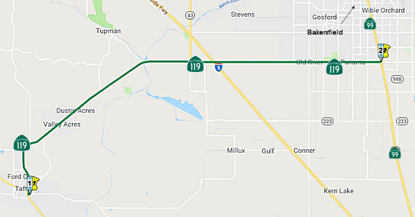
case, by 1956, US 399 was using the alignment used by today's Route 119:
veering off the West Side Highway/Kern Street at Taft Highway. It merges
with the old allignment, Harrison St. just N of the town of Taft in a
community called Ford City. Note that Harrison Street continues NE after
the first merge to meet Taft Highway again, at a point E of Elk Hills
Road; that portion of Harrison Street was the original US 399 prior to the
Taft Highway realignment.
In 1952, a freeway alignment was adopted for US 399 (now Route 33 and Route 119)
through Taft. The plan was to widen US 399 through Taft to a point 1.3mi N
of the town's city limits. Project plans were under study The bypass was
constructed in 1956. Subsequent discussion on the Facebook post where this
map was posted indicated that the final adopted routing differed slightly
from the routing shown. Specifically, the proposed route seems to show the
new routing running along Monroe St, whereas the actually routing runs
about 6-7 blocks to the E, running straight to the N and curving back
after passing what is shown as the US Navy land in the diagram. In any
case, by 1956, US 399 was using the alignment used by today's Route 119:
veering off the West Side Highway/Kern Street at Taft Highway. It merges
with the old allignment, Harrison St. just N of the town of Taft in a
community called Ford City. Note that Harrison Street continues NE after
the first merge to meet Taft Highway again, at a point E of Elk Hills
Road; that portion of Harrison Street was the original US 399 prior to the
Taft Highway realignment.
(Source: Art Moore on FB, 12/22/2022, sharing map from the Bakersfield Californian, 12/23/1952)
US 399 continued E along Taft Highway. Near the N Coles Oil Field, US 399 originally veered off along today's Golf Course Road and Tupman Road (now Golf Course Road, until it crosses Taft Highway and becomes Tupman again). That loop was cutoff by the construction of Taft Highway. US 399 continued along Taft Highway into Greenfield, where it met US 99.
Sign Route 119 was not defined as part of the initial state signage of routes in 1934. It is unclear what (if any) route was signed as Sign Route 119 between 1934 and 1964.
 Status
In October 2011, the CTC approved for future consideration of funding a project that will construct a four-lane bypass near the city of Taft (~ KER 0.017). The project is not fully funded. The project is programmed in the 2010 State Transportation Improvement Program for Project Development only. The total estimated cost is $67,716,000 for capital and support. Depending on the availability of funding construction can begin as early as Fiscal Year 2015- 16. The scope as described for the preferred alternative is consistent with the project scope programmed by the Commission in the 2010 State Transportation Improvement Program. A copy of the MND has been provided to Commission staff. The project will mitigate potential impacts to biological and paleontological resources to a less than significant level. Potential impacts to biological resources in the project area will be mitigated in accordance with the Biological Opinion rendered by the U.S. Fish and Wildlife Service. Potential impacts to paleontological resources would be mitigated by implementing a paleontological resource plan. As a result, an MND was completed for this project.
The state is planning a $70 million upgrade along seven miles of Route 119 E of Taft, as phase one of a $250 million, 30-year road-widening project (~ KER 0.017 to KER 7.000).
In August 2019, it was reported that SB1 will contribute $940,000 to
construct left turn lanes on Route 119 from north of Gardner Field Road (~
KER 0.041) to south of Ash Street (~ KER 1.061) in the city of Taft. The
total cost of the project is $5.2 million.
(Source: Sun Gazette, 8/21/2019)
Truck Passing Lanes - Tupman Road to Elk Hills Road (06-Ker-119 R10.0/R13.3)
In August 2015, the CTC authorized 6,814,000 for a project along Route 119 (06-Ker-119 R10.0/R13.3) near Dustin Acres, from Elk Hills Road to Tupman Road. Outcome/Output: Construct truck climbing lanes to reduce congestion and improve highway operations and mobility.
In April 2016, it was reported that construction was
starting on the new truck passing lanes on Route 119. More information was
provided in an article from Bakersfield Now. The construction project will
add an additional "truck climbing" lane on westbound Route 119 from Tupman
Road to Elk Hills Road, that will connect with two lanes currently in the
area. Shoulders will be widened on the north side of Route 119, an
eastbound passing lane will be extended to Elk Hills Road, and Caltrans
will add a rumble strip along the center line. Engineers say that will
give trucks more space to climb the hills, and give other drivers more
room to pass. The entire project will take about 7 months. As part of the
construction, a 3½ mi long, bright orange fence has been erected
along the north side of the road. The purpose of the fence is to protect
three endangered species: the San Joaquin antelope squirrel, the Giant
kangaroo rat, and San Joaquin kit fox. The long, fabric fence was
installed a foot below ground, and 2-and-a-half feet above. It also has an
8-inch flap ("lip") that folds over away from the highway side. Both the
giant kangaroo rat and antelope squirrel are pretty good climbers, and the
lip may keep them from getting into the construction zone. On the other
hand, the barrier actually helps the kit fox get over the fence. The kit
fox can likely jump over the fence on its own, but Caltrans has added
ramps to provide additional access to the other side of the fence if a kit
fox finds itself in the construction zone at night-- when the species is
most active.
(Source: Taft Midway Driller, 4/7/2016; BakersfieldNow,
4/14/2016)
In May 2016, the CTC approved for future consideration of funding a project that will construct a roundabout at the intersection of Route 43, Route 119, and Enos Lane near the city of Taft (~ KER 18.037). The project is programmed in the 2014 State Highway Operation and Protection Program. The total programmed amount is $9,761,000 for capital and support. Construction is estimated to begin in Fiscal Year 2017-18. The scope, as described for the preferred alternative, is consistent with the project scope programmed by the Commission in the 2014 State Highway Operation and Protection Program. A copy of the MND has been provided to Commission staff. The project will result in less than significant impacts to the environment after mitigation. The following resource area may be impacted by the project: biological resources. Avoidance and minimization measures will reduce any potential effects on the environment. These measures include, but are not limited to, environmentally sensitive areas will be established for the Giant kangaroo rat, Tipton kangaroo rat, San Joaquin kit fox, and the Blunt-nosed leopard lizard, pre-construction field surveys will be conducted, and ESA fencing will be used.
 Naming
This route is part of the "Bakersfield, Maricopa, and Ventura Highway".
 This route is currently named the "Taft Highway".
It was named for its terminus in Taft, CA. According to Wikipedia, a
display at the West Kern Oil Museum indicates that local residents asked
the Southern Pacific Railroad if the station could be named Moro when the
rails arrived in about 1900, but a railroad official declined because the
name would be too easily confused with the coastal town of Morro Bay.
Instead, the railroad directed the station be called Moron, a word which
as yet had no association with lack of intelligence. Pictures of local
businesses, including the Moron Pharmacy, hang in the museum. After a fire
burned much of the town, the name was changed to Taft in honor of William
Howard Taft, the 27th President of the US.
This route is currently named the "Taft Highway".
It was named for its terminus in Taft, CA. According to Wikipedia, a
display at the West Kern Oil Museum indicates that local residents asked
the Southern Pacific Railroad if the station could be named Moro when the
rails arrived in about 1900, but a railroad official declined because the
name would be too easily confused with the coastal town of Morro Bay.
Instead, the railroad directed the station be called Moron, a word which
as yet had no association with lack of intelligence. Pictures of local
businesses, including the Moron Pharmacy, hang in the museum. After a fire
burned much of the town, the name was changed to Taft in honor of William
Howard Taft, the 27th President of the US.
(Image source: US Ends; Whitehouse.Gov)
 The portion of Route 119 between between E Kern Street (KER 0.34) and Cedar Street (KER 1.300)
in the County of Kern is named the “Corporal Luis Carlos Ruan
Memorial Highway”. It was named in memory of Luis
Carlos Ruan, who was born in January 1997, in Long Beach, California. Luis
moved to Taft, California, when he was eight years of age where he
attended Jefferson Elementary, Roosevelt School, and Lincoln Junior High,
and graduated from Taft Union High in 2015. Luis volunteered to serve his
country, enlisting in the United States Army in the summer of 2016, which
he hoped would help him achieve his goal of going to school and joining
the California Highway Patrol. Luis left for the United States Army in
August 2016, and was sent to boot camp in Fort Benning, Georgia. After
graduating from boot camp in December 2016, Luis was stationed in Fort
Bliss, Texas. Luis worked for B Company, 1st Battalion, 36th
Infantry Regiment, 1st Armored Brigade Combat Team, 1st
Armored Division. Luis was in a military training accident on January 22,
2019, in which two other young men passed away, leaving him with a
traumatic brain injury and he was sent to different hospitals while he and
his family started their journey to his recovery. Luis was returned to El
Paso, Texas, where he passed away on April 20, 2020. Named by Assembly
Resolution ACR 211, Res. Chapter 172, 09/06/22.
The portion of Route 119 between between E Kern Street (KER 0.34) and Cedar Street (KER 1.300)
in the County of Kern is named the “Corporal Luis Carlos Ruan
Memorial Highway”. It was named in memory of Luis
Carlos Ruan, who was born in January 1997, in Long Beach, California. Luis
moved to Taft, California, when he was eight years of age where he
attended Jefferson Elementary, Roosevelt School, and Lincoln Junior High,
and graduated from Taft Union High in 2015. Luis volunteered to serve his
country, enlisting in the United States Army in the summer of 2016, which
he hoped would help him achieve his goal of going to school and joining
the California Highway Patrol. Luis left for the United States Army in
August 2016, and was sent to boot camp in Fort Benning, Georgia. After
graduating from boot camp in December 2016, Luis was stationed in Fort
Bliss, Texas. Luis worked for B Company, 1st Battalion, 36th
Infantry Regiment, 1st Armored Brigade Combat Team, 1st
Armored Division. Luis was in a military training accident on January 22,
2019, in which two other young men passed away, leaving him with a
traumatic brain injury and he was sent to different hospitals while he and
his family started their journey to his recovery. Luis was returned to El
Paso, Texas, where he passed away on April 20, 2020. Named by Assembly
Resolution ACR 211, Res. Chapter 172, 09/06/22.
(Image source: Tribute Archive)
 The portion of Route 119 between Enos Lane and Route 99 (~ KER 18.222 to KER 31.198),
and continuing along Taft Hwy/Panama Road to Route 184, in the County of
Kern is officially designated the "Vietnam Veterans Memorial Highway".
It was named to recognize the strong commitment and courage demonstrated
by veterans of the Vietnam War. It was spearheaded by The Veterans of the
Vietnam War, Inc. and The Veterans Coalition, who welcome members from all
branches of service, Navy, Marines, Army, Air Force or Coast Guard, from
all eras, wars and conflicts. The Bakersfield Post of The Veterans of the
Vietnam War, Inc. was established in 1993 and the first Commander was
Barney Cadena and The Bakersfield Post of The Veterans of the Vietnam War,
Inc. was named in his honor in April 2004. The members of The Bakersfield
Post of The Veterans of the Vietnam War, Inc. have been involved in the
Kern County Honor Guard for veteran's funerals and have attended over 750
funerals in 2005. Named by Senate Concurrent Resolution (SCR) 68,
Resolution Chapter 95, on 8/15/2006.
The portion of Route 119 between Enos Lane and Route 99 (~ KER 18.222 to KER 31.198),
and continuing along Taft Hwy/Panama Road to Route 184, in the County of
Kern is officially designated the "Vietnam Veterans Memorial Highway".
It was named to recognize the strong commitment and courage demonstrated
by veterans of the Vietnam War. It was spearheaded by The Veterans of the
Vietnam War, Inc. and The Veterans Coalition, who welcome members from all
branches of service, Navy, Marines, Army, Air Force or Coast Guard, from
all eras, wars and conflicts. The Bakersfield Post of The Veterans of the
Vietnam War, Inc. was established in 1993 and the first Commander was
Barney Cadena and The Bakersfield Post of The Veterans of the Vietnam War,
Inc. was named in his honor in April 2004. The members of The Bakersfield
Post of The Veterans of the Vietnam War, Inc. have been involved in the
Kern County Honor Guard for veteran's funerals and have attended over 750
funerals in 2005. Named by Senate Concurrent Resolution (SCR) 68,
Resolution Chapter 95, on 8/15/2006.
(Image source: Gribblenation)
 The interchange of Route 99 and Route 119 (~ KER 31.198) is named the "Deputy
Daniel Lee Archuleta Memorial Interchange". Named in memory of
Daniel Lee Archuleta, who was born in Huntington Beach, California. Daniel
Lee Archuleta attended Golden West College, where he received an Associate
of Arts degree on October 20, 1996, and subsequently attended California
State University at Long Beach, where he received a bachelor's degree on
May 28, 1999. Daniel Lee Archuleta attended, and graduated from, the
academy of the Los Angeles County Sheriff's Department at East Los Angeles
College on February 20, 2001, and began employment with the Los Angeles
County Sheriff's Department in February of 2001. Archuleta was hired by
the Kern County Sheriff's Department on October 5, 2002, and was assigned
to the Support Services Bureau, the Training Division, and the Resource
Pool, and also worked temporarily in the Court Services Division. Daniel
Lee Archuleta transferred to the Law Enforcement Bureau, South Area
Substation Division, Taft Court on November 2, 2002, and on May 27, 2003,
he entered the Field Training Officer Program and was promoted to Deputy
Sheriff II on October 4, 2003. Daniel Lee Archuleta was killed on
September 12, 2004, when his patrol vehicle rolled over on Tupman Road,
just north of the west Kern County town of Tupman, while he was traveling
south on Tupman Road responding to an emergency call. A deputy from the
Kern County Sheriff's Department driving north on Tupman Road found the
battered patrol vehicle in the southbound lane of Tupman Road, and Daniel
Lee Archuleta was found dead at the scene. California Highway Patrol
investigative units from Bakersfield and Fresno were called to the scene
but were unable to ascertain the cause of the accident. Named by Senate
Concurrent Resolution 50, Resolution Chapter 86, on August 24, 2012.
The interchange of Route 99 and Route 119 (~ KER 31.198) is named the "Deputy
Daniel Lee Archuleta Memorial Interchange". Named in memory of
Daniel Lee Archuleta, who was born in Huntington Beach, California. Daniel
Lee Archuleta attended Golden West College, where he received an Associate
of Arts degree on October 20, 1996, and subsequently attended California
State University at Long Beach, where he received a bachelor's degree on
May 28, 1999. Daniel Lee Archuleta attended, and graduated from, the
academy of the Los Angeles County Sheriff's Department at East Los Angeles
College on February 20, 2001, and began employment with the Los Angeles
County Sheriff's Department in February of 2001. Archuleta was hired by
the Kern County Sheriff's Department on October 5, 2002, and was assigned
to the Support Services Bureau, the Training Division, and the Resource
Pool, and also worked temporarily in the Court Services Division. Daniel
Lee Archuleta transferred to the Law Enforcement Bureau, South Area
Substation Division, Taft Court on November 2, 2002, and on May 27, 2003,
he entered the Field Training Officer Program and was promoted to Deputy
Sheriff II on October 4, 2003. Daniel Lee Archuleta was killed on
September 12, 2004, when his patrol vehicle rolled over on Tupman Road,
just north of the west Kern County town of Tupman, while he was traveling
south on Tupman Road responding to an emergency call. A deputy from the
Kern County Sheriff's Department driving north on Tupman Road found the
battered patrol vehicle in the southbound lane of Tupman Road, and Daniel
Lee Archuleta was found dead at the scene. California Highway Patrol
investigative units from Bakersfield and Fresno were called to the scene
but were unable to ascertain the cause of the accident. Named by Senate
Concurrent Resolution 50, Resolution Chapter 86, on August 24, 2012.
(Image source: National Law Enforcement Officers Memorial Fund)
 Statistics
Overall statistics for Route 119:
 Other WWW Links
 Pre-1964 Legislative Route
In 1933, Chapter 767 defined the route from "State Highway near Gilroy to [LRN 10] in Priest Valley" as part of the state highway system. In 1935, it was codified in the highway code as LRN 119 with that definition. In 1953, Chapter 1836 changed the definition to clarify the origin and relax the terminus, making it "[LRN 2] near Gilroy to [LRN 10]".
The route ran from US 101 near Gilroy to Route 198, and is present-day Route 25.
© 1996-2024 Daniel P. Faigin.
Maintained by: Daniel P. Faigin
<webmaster@cahighways.org>.
 From Route
  Route 118
 Route 120