
 California Highways:
Click here for a key to the symbols used. An explanation of acronyms may be found at the bottom of the page.
 Routing
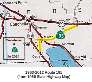 From Route 86 near Oasis to Route 111 near Mecca via Pierce Street and Avenue
66. This route ceases to be a state highway when Route 86 Expressway is
constructed from near Oasis to Route 10.
From Route 86 near Oasis to Route 111 near Mecca via Pierce Street and Avenue
66. This route ceases to be a state highway when Route 86 Expressway is
constructed from near Oasis to Route 10.
 Post 1964 Signage History
In 1963, Route 195 was defined as "Route 86 near Oasis to Route 10 near Shaver's Summit via Pierce Street, Avenue 66, and Mecca."
In 1972, Chapter 1216 deleted the portion between Route 111 and Route 10,
and added a sunset condition: "Route 86 near Oasis to Route 10 near
Shaver's Summit Route 111 near Mecca via Pierce Street
and Avenue 66 and Mecca. This route shall
cease to be a state highway when Route 86 Freeway is constructed from
near Oasis to Route 10."
In 1981, Chapter 292 changed "Freeway" to "Expressway"
By 2003, it appears that Route 195 had been decomisssioned, although it still remains on the books, and shields remain up.
In December 2012, Route 86S was officially resigned as Route 86. Given that Route 86S was former Route 195, it is likely that Route 195 is no longer a state highway.
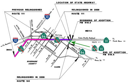 In 2014, a portion of former Route 195 was moved to Route 111. The route adoption noted the history of the route, and specifically
noted how, in March 1988, a supplemental project reported was completed
for a Route 86 expressway between Avenue 82 and Avenue 66 (Route 195) and
for a freeway between Avenue 66 and Dillon Road. This supplemental project
report down scoped the previously approved project on Route 86 from a four
lane freeway to an expressway between Avenue 82 and Avenue 66. In 2001,
the Route 86 Expressway (Route 86S) was completed. The expressway runs
from I-10 at Coachella to join Route 86 at Oasis. The segment from Mecca
to Coachella is a joint section of Route 86 and Route 111. Additionally in
2001, a supplemental project report was completed to address specific
terms of the rehabilitation and relinquishment of existing Route 86, Route 111 and Route 195 in the area. In 2009 the relinquishments for Route 86,
Route 111 and Route 195 were completed. However, a one mile section of
Route 195 between Route 86S (renumbered to Route 86 in December 2012) and
Route 111 (Avenue 66) was not relinquished. Given the definition of Route 195 (which indicates it is no longer a state route), in December 2014 this
segment was adopted as Route 111 Post Mile R18.5 to R19.4.
In 2014, a portion of former Route 195 was moved to Route 111. The route adoption noted the history of the route, and specifically
noted how, in March 1988, a supplemental project reported was completed
for a Route 86 expressway between Avenue 82 and Avenue 66 (Route 195) and
for a freeway between Avenue 66 and Dillon Road. This supplemental project
report down scoped the previously approved project on Route 86 from a four
lane freeway to an expressway between Avenue 82 and Avenue 66. In 2001,
the Route 86 Expressway (Route 86S) was completed. The expressway runs
from I-10 at Coachella to join Route 86 at Oasis. The segment from Mecca
to Coachella is a joint section of Route 86 and Route 111. Additionally in
2001, a supplemental project report was completed to address specific
terms of the rehabilitation and relinquishment of existing Route 86, Route 111 and Route 195 in the area. In 2009 the relinquishments for Route 86,
Route 111 and Route 195 were completed. However, a one mile section of
Route 195 between Route 86S (renumbered to Route 86 in December 2012) and
Route 111 (Avenue 66) was not relinquished. Given the definition of Route 195 (which indicates it is no longer a state route), in December 2014 this
segment was adopted as Route 111 Post Mile R18.5 to R19.4.
 Pre 1964 Signage History
1933-1940 Sign Route 195 (Future US 95/Route 78)

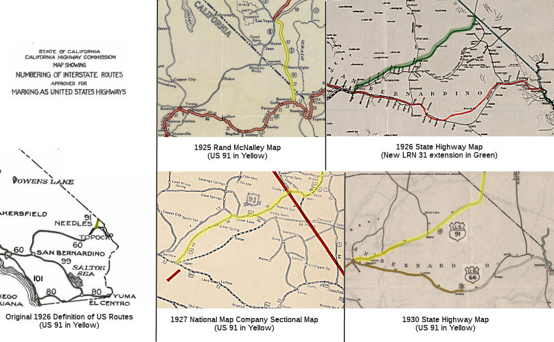 According to the Report of Joint Board on Interstate Highways (October 30, 1925), the original definition of US 91 was "From Great Falls, Montana, to Butte,
Dillon, Idaho Falls, Idaho, Pocatello, Brigham, Utah, Salt Lake City,
Provo, Juab, Filmore, Beaver, Parowan, St. George, Las Vegas, Nevada, to
an intersection with Route № 60." As referenced in the report,
"Route № 60" was not what became US 60, but was US 66. US 60 had
been the original planned number for the US 66 route, but objections from
KY (which wanted an x0 route) led to the number change. Two
existing roads south of Las Vegas to what was planned as US 60 were
immediately available: the Los Angeles-Salt Lake Road towards
Daggett, or the Arrowhead Trail that was aligned directly south
into California to Bannock. North of Las Vegas, NV, the Arrowhead Trail
was multiplexed with the National Park-to-Park Highway and Evergreen
National Highway, according to the 1924 Rand McNally Map of California. South of Las Vegas, the two diverged. The Arrowhead Trail largely followed the path of the Los
Angeles-Salt Lake Road but detoured significantly south of Las Vegas via
NV 5 towards Bannock (Bannock is a reference point just W of Arrowhead
Jct., which is W of Needles). On December 26, 1920, the Los Angeles
Times reported that the Arrowhead Trails Association proposed a major
realignment south of Las Vegas known as the "Silver Lake Cutoff."
The Silver Lake Cutoff would initially follow Las Vegas Boulevard to Jean,
Goodsprings Road to Goodsprings. Within Goodsprings the Arrowhead
Trail followed Spring Street, Esmerald Street, Reimann Road and Columbia
Mill Road. West of the Goodsprings the Silver Lake Cutoff followed
what is now Sandy Valley Road over Columbia Pass and Kingston Road to the
California state line near Ripley (now Sandy Valley). The Silver
Lake Cutoff within California would branch southward from the Nevada state
line via Kingston Road, Winters Pass and Silver Lake towards
Daggett. The cutoff ultimately would save approximately 90 miles of
travel through the Mojave Desert. The Silver Lake Cutoff was similar to
the previous Los Angeles-Salt Lake Road but followed a more northern path
to utilize the Tonopah & Tidewater Railroad sidings of Silver Lake as
a waypoint. This new routing of the Arrowhead Trail via the Silver Lake
Cutoff was ultimately paved with oiled earth in 1925 by San Bernardino
County.
According to the Report of Joint Board on Interstate Highways (October 30, 1925), the original definition of US 91 was "From Great Falls, Montana, to Butte,
Dillon, Idaho Falls, Idaho, Pocatello, Brigham, Utah, Salt Lake City,
Provo, Juab, Filmore, Beaver, Parowan, St. George, Las Vegas, Nevada, to
an intersection with Route № 60." As referenced in the report,
"Route № 60" was not what became US 60, but was US 66. US 60 had
been the original planned number for the US 66 route, but objections from
KY (which wanted an x0 route) led to the number change. Two
existing roads south of Las Vegas to what was planned as US 60 were
immediately available: the Los Angeles-Salt Lake Road towards
Daggett, or the Arrowhead Trail that was aligned directly south
into California to Bannock. North of Las Vegas, NV, the Arrowhead Trail
was multiplexed with the National Park-to-Park Highway and Evergreen
National Highway, according to the 1924 Rand McNally Map of California. South of Las Vegas, the two diverged. The Arrowhead Trail largely followed the path of the Los
Angeles-Salt Lake Road but detoured significantly south of Las Vegas via
NV 5 towards Bannock (Bannock is a reference point just W of Arrowhead
Jct., which is W of Needles). On December 26, 1920, the Los Angeles
Times reported that the Arrowhead Trails Association proposed a major
realignment south of Las Vegas known as the "Silver Lake Cutoff."
The Silver Lake Cutoff would initially follow Las Vegas Boulevard to Jean,
Goodsprings Road to Goodsprings. Within Goodsprings the Arrowhead
Trail followed Spring Street, Esmerald Street, Reimann Road and Columbia
Mill Road. West of the Goodsprings the Silver Lake Cutoff followed
what is now Sandy Valley Road over Columbia Pass and Kingston Road to the
California state line near Ripley (now Sandy Valley). The Silver
Lake Cutoff within California would branch southward from the Nevada state
line via Kingston Road, Winters Pass and Silver Lake towards
Daggett. The cutoff ultimately would save approximately 90 miles of
travel through the Mojave Desert. The Silver Lake Cutoff was similar to
the previous Los Angeles-Salt Lake Road but followed a more northern path
to utilize the Tonopah & Tidewater Railroad sidings of Silver Lake as
a waypoint. This new routing of the Arrowhead Trail via the Silver Lake
Cutoff was ultimately paved with oiled earth in 1925 by San Bernardino
County.
(Source: Gribblenation Blog, "The Vague Original Southern Terminus of US Route 91 in the Californian MoSjave Desert", 9/22/2019)
The original report is ambiguous on the original planned routing of US 91
to US 66; however, based on the January 1926 issue of CHPW, the original plan was to route US 91
into California along future LRN 146, using the National Park-to-Park
Highway/Evergreen National Highway/(original pre-1920) Arrowhead
Trail routing northerly from Needles into Nevada, where it
connected with NV 5. This route was LRN 146, first defined in 1933 and
codified in 1935, which was signed as Sign Route 195 in 1934; with the
1940 extension of US 95 into California, the route became US 95. It does
appear that the plans for using the LRN 146 routing for US 91 were
short-lived. A 1924 Auto Trails map shows the future LRN 146 route as the
more significant trail, and a 1925 map shows US 91 running along the
future LRN 146/Future Sign Route 195 route, although this was likely based
on anticipation or early data as the US route system was not yet official.
(Source: Supplemental research via "The Vague Original Southern Terminus of US Route 91 in the Californian Mojave Desert", 9/22/2019)
By 1925, it appeared that the plan was to move US 91 to the new Arrowhead
Trail routing once the route was suitably improved. In 1926, the
legislature approved the extension of LRN 31 from Barstow to the Nevada
State Line; a 1926 map shows a planned state highway running along the
route through Baker and into Daggett. The June 1925 California
Highways & Public Works reported that the Arrowhead Trail north of
Daggett to the Nevada state line was formally under California Division of
Highways maintenance. A 1927 map shows US 91 using a route through
Silver Lake and Bitter Spring into Daggett instead of the LRN 146 route;
by the 1930 map, the route through Baker and into Barstow (by then the
terminus has been moved from Daggett) was clearly signed as US 91.
(Source: Supplemental research via "The Vague Original Southern Terminus of US Route 91 in the Californian Mojave Desert", 9/22/2019)
95.jpg" ALT="Rte 195: From Rte 195 to U.S. 95"
TITLE="Rte 195: From Rte 195 to U.S. 95" class="hwymap">The movement of US 91 to LRN 31, of course, left the question of its former routing S from
Las Vegas along NV 5 and into Needles. That routing first entered the
state highway system in 1933, when Chapter 767 added the following routes:
In 1935, this was codified as LRN 146, which was added to the highway code with the following routings:
All of these portions were signed as Sign Route 195. In 1940, US 95
was extended into California all the way to Blythe. At this time, both NV
5 and Sign Route 195 were renumbered as US 95. It appears that Sign Route 195 signage was removed from the portion S of Blythe at that time (at
least it isn't shown on maps). The portion of LRN 146 from Blythe S to
Palo Verde would be extended SW to Brawley in 1959, and the entire route
renumbered as Route 78 in 1964, although the portion S of Palo Verde was
signed as County Sign Route S78 until construction was completed.
As for US 95:
In a letter dated October 4, 1938, the Nevada State Highway Engineer
requested information from the AASHO Executive Secretary pertaining to a
1937 request to extend US 95 through Nevada to Blythe, California.
The origin point for the proposed extension of US 95 was to be the Idaho
Oregon Nevada Highway (I.O.N. Highway #456) at McDermitt at the
Oregon/Neveda state line. The AASHO Executive Secretary replied on
October 8, 1937, indicating that the Oregon Department of Transportation
stated I.O.N. #456 was not ready to facilitate modern automotive
travel. The AASHO Executive Committee's opinion was to hold off on
the extension of US 95 until I.O.N Highway #456 was completed in
Oregon. On May 20, 1939, the Nevada State Highway Engineer again
petitioned the AASHO Executive Committee to extend US 95 through
Nevada. The Nevada State Highway Engineer noted NV 8 had been fully
paved from Winnemucca to the Oregon State Line since 1936 and was ready to
be assigned as US 95 despite I.O.N. Highway #456 not being
completed. The Nevada State Highway Engineer's letter was met with a
reply by the AASHO Executive Secretary on May 24, 1939. The
Executive Secretary stated once notification of the completion of I.O.N.
Highway #456 was received from the Oregon Department of Transportation the
AASHO Executive Committee would likely take action to extend US 95.
(Source: Gribblenation Blog (Tom Fearer), "Interstate 10 in the Sonoran Desert between the Colorado River and Coachella Valley", 10/14/2023)
A letter dated June 2, 1939, from the AASHO Executive Secretary to the
State Highway engineers of; California, Nevada, Oregon and Idaho noted the
proposed alignment of US 95 south to Blythe, California. A separate
letter to the Nevada State Highway Engineer notes that a last-minute
request was made to extend US 93 south of Las Vegas to the California
State Line via Searchlight over NV 5 instead of US 95. A letter
dated June 10, 1939, by the AASHO Executive Secretary to the President of
the AASHO states that the Nevada State Highway Engineer attempted to get
US 95 into Nevada before the completion of I.O.N. Highway #456 under the
pretenses that a like interim measure was permitted for the extension of
US 6 to California. I.O.N Highway #456 was anticipated to be
completed sometime during 1940. The AASHO Executive Secretary
advised the Highway Engineers of California, Nevada, Oregon and Idaho in a
letter dated July 7, 1939, that the AASHO Executive Committee approved the
extension of US 95 to Blythe, California. US 95 absorbed the
existing routing of Sign Route 195/LRN 146 from the Nevada State Line
south to US 60/US 70/LRN 64 at Hobson Way in Blythe. Upon the
extension of US 95 into California the original Sign Route 195 was
deleted. The Sign Route 195 number was reassigned to the former
routing of US 60/US 70 via the spur of LRN 64 in Box Canyon.
(Source: Gribblenation Blog (Tom Fearer), "Interstate 10 in the Sonoran Desert between the Colorado River and Coachella Valley", 10/14/2023)
This route was originally signed as Sign Route 195, and renumbered as US 95 upon the definition of US 95 in the late 1930s (at which point the original 1934 Sign Route 95 (see below) was renumbered as US 395). This segment was LRN 146, defined in 1933.
US 95 was approved to be extended from Blythe to the Mexican border at
San Luis, Arizona, by the AASHO Executive Committee on June 28,
1960. US Route 95 from Intake Boulevard multiplexed US 60/US 70 and
planned I-10 along Hobson Way to the Colorado River and Arizona state
line. The extension of US 95 to the Mexican border was desired by
the Arizona Highway Department and was not objected by the Division of
Highways. US 95 currently multiplexes along I-10 to Quartzite AZ,
and then continues S to Mexico via Yuma AZ.
(Source: Gribblenation Blog (Tom Fearer), "US Route 95 in California", 5/20/2023; originally part of "2016 Cross-Country Trip Part 5; Retrospective California State Route 62 and US Route 95", 4/2018)
1940-2012 Route 195 (Box Canyon Road)
 In 1931, LRN 64 was extended to the California Nevada state
line from Blythe. In 1932, US 60 was extended from Texas to downtown Los
Angeles. In 1934, US 70 was extended to Los Angeles, and US 60/US 70 was
signed along Box Canyon. In 1935, US 60/US 70 was rerouted on a spur of
LRN 64 called the "Indio Cut Off", and it saved 9 miles over the Box
Canyon routing. It is unclear what signage was left on Box Canyon Road at
that time, although it remained under state maintenance.
In 1931, LRN 64 was extended to the California Nevada state
line from Blythe. In 1932, US 60 was extended from Texas to downtown Los
Angeles. In 1934, US 70 was extended to Los Angeles, and US 60/US 70 was
signed along Box Canyon. In 1935, US 60/US 70 was rerouted on a spur of
LRN 64 called the "Indio Cut Off", and it saved 9 miles over the Box
Canyon routing. It is unclear what signage was left on Box Canyon Road at
that time, although it remained under state maintenance.
In 1940, with the creation of US 95 over what was then Sign Route 195 on
LRN 146, the designation of Sign Route 195 was shifted to Box Canyon Road
spur of LRN 64. This instantiation was routed from US 60/70 at Chiriaco
Summit southwest to Sign Route 111 in Mecca. LRN 64 was actually a route
with a spur: the original LRN 64 carrying Sign Route 195 on Box Canyon
Road, and a spur of LRN 64 carrying US 60/US 70 on the north segment. Some
portions of Route 195 were LRN 203 and LRN 204: The portion of Route 195
that was moved to Route 111 in 2014 was LRN 203, defined in 1935 and the
portion of LRN 204 (also defined in 1935) between Pierce Street and Route 111.
(Some information sourced from: Gribblenation Blog:
Old US Route 60/70 through Hell (Chuckwall Valley Road and Ragsdale Road); Gribblenation Blog: "BoxCanyon
Road (former US 60, US 70 and the second California State
Route 195)")
Additionally, according to Scott Parker on AAroads: "1934-era Route 195
was ever-so-briefly part of US 91 prior to US 95 being commissioned over
that route plus the remainder of Route 195 down to Blythe. US 66
originally followed the Santa Fe (now BNSF, of course) main line that
paralleled its Goffs Rd. alignment before the cut-off that's now part of
I-40 was built in the '30's. The commissioning of US 95 came at
approximately the same time as that of US 395 to the west, which subsumed
both the northern part of original Sign Route 7 but also the original Sign
Route 95 between US 66 at Hesperia via Kramer Corners to Inyokern. For the
first quarter-century of the CA state highway network, the designation of
the desert arterials was constantly in a state of flux until the U.S.
highway system essentially "maxed out" right after WW II. According to Tom
Fearer, the 1926 State Highway map shows US 91 ending in Daggett, but by
1928 the state maintenance had shifted west to Barstow to 1st
Avenue.
(Source: Scott Parker (SParker), Tom Fearer (Max Rockatansky). on AAroads, 4/19/2018)
 Status
The Route 86 expressway has been completed; as of 2003, however, the state highway signage for Route 195 has not been removed.
In July 2008, the CTC relinquished right of way in the county of Riverside on: Route 86 between Route 86S and Avenue 54 including adjacent right of way along Route 86 for drainage purposes (8-Riv-86-PM 2.68/18.32); Route 111 between Route 195 and Route 86S (8-Riv-111-PM 18.48/20.05), and between Route 86S and the boundary line between Riverside County and the city of Coachella (8-Riv-111-PM 20.13/25.12); and Route 195 between Route 86 and Route 86S (8-Riv-195-PM 0.00/6.45), consisting of superseded highway right of way and collateral facilities.
 National Trails
 The portion of this route (as Sign Route 195) from Las
Vegas NV to Needles CA was part of the Evergreen National Highway.
The portion of this route (as Sign Route 195) from Las
Vegas NV to Needles CA was part of the Evergreen National Highway.
 Other WWW Links
 Statistics
Overall statistics for Route 195, as of 1995:
 Pre-1964 Legislative Route
In 1933, Chapter 767 defined the route from "[LRN 2] near Oceanside to Descanso-Temecula Road near Lake Henshaw" as part of the state highway system. In 1935, this route was added to the highway code as LRN 195, with the definition:
This definition remained unchanged until the 1963 renumbering. It ran from US 101 (present-day I-5) near Oceanside to Route 79 near Lake Henshaw. This is present-day Route 76.
© 1996-2024 Daniel P. Faigin.
Maintained by: Daniel P. Faigin
<webmaster@cahighways.org>.
 Route 194
 Route 196