
 California Highways:
Click here for a key to the symbols used. An explanation of acronyms may be found at the bottom of the page.
 Routing
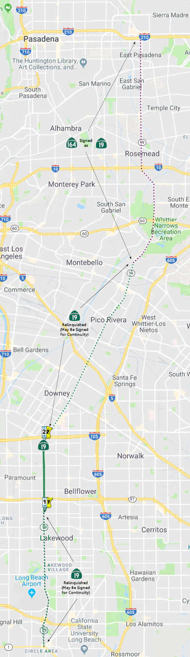 (a) Route 19 is from the northern city limit of the City of
Lakewood to Gardendale Street/Foster Road in the Cities of Bellflower and
Downey.
(a) Route 19 is from the northern city limit of the City of
Lakewood to Gardendale Street/Foster Road in the Cities of Bellflower and
Downey.
(b) If the commission determines it is in the state's best interests to do so, it may do the following, pursuant to a cooperative agreement between the respective city and the department:
(1) Relinquish to the City of Bellflower the portion of Route 19 between the city's southerly city limit near Rose Avenue and Gardendale Street/Foster Road.
(2) Relinquish to the City of Downey the portion of Route 19 between the city's southerly city limit at Century Boulevard and Gardendale Street.
(c) A relinquishment under this section shall become effective when the county recorder records the relinquishment resolution containing the commissioner's approval of the relinquishment's terms and conditions.
(d) Any portion of Route 19 relinquished pursuant to this section shall cease to be a state highway on the effective date of the relinquishment.
(e) The relinquished former portions of Route 19 within the Cities of Downey, Lakewood, Long Beach, and Pico Rivera are not state highways and are not eligible for adoption under Section 81. For the relinquished former portions of Route 19, the Cities of Downey, Lakewood, Long Beach, and Pico Rivera shall maintain within their respective jurisdictions signs directing motorists to the continuation of Route 19. The City of Lakewood shall ensure the continuity of traffic flow on the relinquished former portion of Route 19, including any traffic signal progression.
 Post 1964 Signage History
Route 19 was defined in 1963 to run "from Route 1 near Long Beach to Route 164 near Pico Rivera." Route 164 near Pico Rivera was where Rosemead met Gallatin Road (a few block N of Beverly Blvd).
Note: The portion of the highway in the City of Long Beach ceased to be a state highway pursuant to the terms of a cooperative agreement in 1998 between the City of Long Beach and the department providing for the relinquishment of that portion of the highway to that city. The Long Beach relinquishment was authorized by AB 2132, Chapter 877, signed September 26, 1998. The authorization for relinquishment of the portion in the City of Downey came from Senate Bill 803, Chapter 172, signed 7/23/1999.
In 2003, the legislative definition was changed by AB 535 (8/4/2003, Chapter 177) to acknowledge various relinquishments, and to permit some additional ones. The pre-2003 definition was:
From Route 1 near Long Beach to Route 164 near Pico Rivera, excepting the following portions once they have been relinquished by appropriate agreements:
- The portion of Route 19 that is between Del Amo Boulevard in the City of Long Beach and Route 1. Reliquished by cooperative agreement.
- The portion of Route 19 between Gardendale Street and Telegraph Boulevard with the City of Downey, upon approval of the California Transportation Commission.
Upon reliquishment, the definition of Route 19 will be:
- Del Amo Boulevard near Long Beach to Gardendale Street in Downey.
- The Downey city limit at Telegraph Road to Route 164 (Galatin Road) near Pico Rivera.
In 2010, the legislative definition was changed by SB 1381 (9/29/10,
Chapter 421) and SB 993 (9/29/2010, Chapter 499). The latter change was
the one that took, as it was the later chapter. This modification changed
the definition to not mention the portion relinquished in Pico Rivera
(which was up for relinquishment in 2004) and to add the portion
relinquished in Lakewood. Specifically, (a) was changed as follows: "From
Del Amo Boulevard near Long Beach to Gardendale Street/Foster Road in the
Cities of Bellflower and Downey, and then, with an interruption of
already relinquished route, from Telegraph Road at the Downey City limit
to Route 164 (Galatin Road) at the northerly city limit of Pico Rivera.".
(b) was added, and the 2003-2010 item (3) "To the City of Pico
Rivera: The portion of Route 19 between Telegraph Road and Gallatin
Road. (This was up for relinquishment in May 2004)" was deleted
and replaced with the Lakewood wording, and (c)-(e) were added. The
portion of the route in Lakewood was relinquished in March 2012.
In 2013, SB 788 (Ch. 525, 10/9/13) changed the definition again:
(a) Route 19 is from
Del Amo Boulevard near Long Beachthe northern city limit of the City of Lakewood to Gardendale Street/Foster Road in the Cities of Bellflower and Downey.(b) If the commission determines it is in the state's best interests to do so, it may do the following, pursuant to a cooperative agreement between the respective city and the department:
(1) Relinquish to the City of Bellflower the portion of Route 19 between the city's southerly city limit near Rose Avenue and Gardendale Street/Foster Road.
(2) Relinquish to the City of Downey the portion of Route 19 between the city's southerly city limit at Century Boulevard and Gardendale Street.
(3) Relinquish to the City of Lakewood the portion of Route 19 that is within the city limits or the sphere of influence of the city.(c) A relinquishment under this section shall become effective when the county recorder records the relinquishment resolution containing the commissioner's approval of the relinquishment's terms and conditions.
(d)
(1)Any portion of Route 19 relinquished pursuant to this section shall cease to be a state highway on the effective date of the relinquishment.
(2) The portion of Route 19 relinquished under paragraph (3) of subdivision (b) may not be considered for future adoption under Section 81.
(3) For the portion of Route 19 relinquished under paragraph (3) of subdivision (b), the city shall ensure the continuity of traffic flow, including any traffic signal progression, and shall maintain signs directing motorists to the continuation of Route 19.(e) The relinquished former portions of Route 19 within the Cities of Downey, Lakewood, Long Beach, and Pico Rivera are not state highways and are not eligible for adoption under Section 81. For the relinquished former portions of Route 19, the Cities of Downey, Lakewood, Long Beach, and Pico Rivera shall maintain within their respective jurisdictions signs directing motorists to the continuation of Route 19. The City of Lakewood shall ensure the continuity of traffic flow on the relinquished former portion of Route 19, including any traffic signal progression.
In May 2017, the CTC actually relinquished right of way in the city of Bellflower on Route 19 from the south city limits near Rose Street to the north city limits at Gardendale Street (07-LA-19 PM 5.5/8.4), under terms and conditions as stated in the relinquishment agreement, determined to be in the best interest of the State. The City is expected to approve the relinquishment agreement at their April 24, 2017 council meeting. Authorized by Chapter 499, Statutes of 2010, which amended Section 319 of the Streets and Highways Code. This relinquishment included a financial contribution of $4,500,000.
In December 2019, the CTC authorized relinquishment of right of way in
the city of Downey (City) on Route 19 (Lakewood Boulevard), under terms
and conditions as stated in the relinquishment agreement dated September
10, 2019, determined to be in the best interest of the State. Authorized
by Chapter 597, Statutes of 2001, which amended Section 319 of the Streets
and Highways Code.
(Source: December 2019 CTC Agenda, Agenda Item
2.3c)
This routing runs along Rosemead and Lakewood Blvds. Note: Route 164 from Route 19 to Route 210 is signed as Route 19. The designation as Route 19 is older, and by the 1950s was along Rosemead until Colorado Blvd.
 Pre 1964 Signage History
In 1934, Route 19 was signed from Jct. Route 3 (US 101A, later Route 1) near Long Beach to Jct. US 66 near Lamanda Park. This was LRN 168 (defined as a state highway route in 1933). Route 19 ran from the traffic circle in Long Beach exiting N on Bennett Ave, then N along Cerritos Avenue and San Gabriel Blvd to Foothill Blvd. in Sierra Madre.
Early routings included interim alignments in Downey along portions on
Compton Blvd, as well as Firestone Boulevard, Lexington-Gallatin Road,
10th Street and Patton Street.
(Source: Gribblenation Blog (Tom Fearer), “California State Route 19 and unsigned California State Route 164”, April 2022)
In 1935, funding for construction of a new alignment of Route 19/LRN 168
on Rosemead Avenue from US 101/LRN 2 at Whittier Boulevard north to LRN 9
at Foothill Boulevard had been allocated (note, it is unclear if Route 19
signage ever extended north of US 66/LRN 161). 1935 also saw a contract
awarded to construct the new alignment of Route 19/LRN 168 on Rosemead
Boulevard from San Gabriel Avenue 3.5-miles north to US 99/US 60/US 70/LRN 26 at Ramona Boulevard. 1936 saw a planned new alignment of Route 19/LRN 168 between Bellflower and Downey along Farlow Drive. By
1937, contract awards were referencing Lakewood Blvd instead of Cerritos
Avenue between Carson Street and Norwalk Road. 1938 brought confirmation
that Cerritos Avenue was renamed as Lakewood Boulevard, and the portion of
San Gabriel Boulevard was now part of a new alignment of Route 19/LRN 168,
and had been renamed as part of Rosemead Boulevard.
(Source: Gribblenation Blog (Tom Fearer), “California State Route 19 and unsigned California State Route 164”, April 2022)
 Note that after 1947, a portion of Route 19 was cosigned as US 91.
On July 1, 1947, the AASHO Executive Secretary notified the California
State Highway Engineer that California's request to extend US 91 from
Barstow to Long Beach had been approved. This extension brought US 91 to
Long Beach as follows:
Note that after 1947, a portion of Route 19 was cosigned as US 91.
On July 1, 1947, the AASHO Executive Secretary notified the California
State Highway Engineer that California's request to extend US 91 from
Barstow to Long Beach had been approved. This extension brought US 91 to
Long Beach as follows:
In response to the construction of the US 101 freeway, LRN 178 was truncated on its eastern end to Manchester Blvd in 1953, and then to US 101 in 1957. The intent was to route US 91 along the a-building Riverside Freeway (Route 14, LRN 175). Seemingly dependent on the year and the mood of the Dept. of Highways, US 91 would take an appropriate N/S to the closest end of the Riverside Freeway -- be that Manchester/Bypass US 101, Brookhurst St, or State College. This sometimes involved US 91 signage on city streets. But the goal was to get US 91 on US 101 for the jog between Route 14 and Route 18 on Lincoln Ave. The segment along US 101 was part of LRN 174, defined in 1933.
After the 1953 truncation of LRN 178, W of the US 101/Orangethorpe Junction, US 91 then ran E along Orangethorpe, and later the Riverside Freeway, to Santa Ana Canyon, along Route 14 (present-day Route 91). This was part of LRN 175, defined in 1933. Present-day Route 91 follows pre-1964 Route 14 W from the junction with US 101 (now I-5). This is because the post-1964 Route 91 terminates in Hermosa Beach, not Long Beach like US 91 did.
From Santa Ana Canyon, the route ran NE cosigned with Route 18 to Riverside. By 1962, the Route 18 signage was dropped and it was signed as just US 91. This was part of LRN 43, defined in 1931. Riverside is the present-day eastern terminus of Route 91.
The 1927 State of Nevada Department of Highways Map shows US 91
entering California via NV 6 and using the Arrowhead Trail via Silver
Lake. The January 1928 California Highways & Public Works notes
the alignment of US 91 on LRN 31 in California. US 91 is
stated to have enter California via NV 6 through Jean towards
Baker. From Baker US 91 followed LRN 31 southward to
Daggett. This alignment would have taken US 91/LRN 31
through Baker via Baker Boulevard. The 1930 Division of Highways Map
of California shows US 91 routed onto a partially completed and
largely unimproved route of LRN 31 from Barstow via Baker.
(Source: Gribblenation Blog (Tom Fearer),
“Former US Route 91 and US Route 466 in Baker”, April 2021)
Originally, this segment was routed through Daggett. By 1931, the
route ran from N Barstow to Yermo, as evidence in a 1931 Conoco
California-Nevada map by H M Gousha (which shows US 91 going from
Yermo to north of Barstow on a road section constructed in 1930). In
January 1930, California Highways and Public Works noted that the
contractor “is making excellent progress with the grading on
their contract between Barstow and Yermo. This contract includes the
laying of oil-treated plant-mixed surfacing 20 feet wide.”
(Source: Email from Frank Aros)
The Los Alimitos Traffic Circle was the point where Route 1/Former Route 3/US 101A/US 91 and Route 19/US 91 came together. The Los Alamitos Traffic
Circle was located at the junction of State Street, Bennett Avenue and
Hathaway Avenue. 1934 Route 3 followed the entirety of LRN 60, which
by proxy took it through Los Alamitos Traffic Circle in Long Beach.
CA 3 was renumbered as US 101A in 1935; the 1964 renumbering changed it to
the current Route 1. Also meeting in the traffic circle was Route 19/LRN 168, which in 1947 was cosigned with US 91. US 91 would also be extended
along US 101A to meet US 6. The Los Alamitos Traffic Circle originally
only had what is now the inner circle. The inner circle transitioned
the implied connection of Route 3/LRN 60 from Hathaway Avenue to State
Street (both were renamed by 1944 to Pacific Coast Highway). LRN 168
joined the traffic circle via Bennett Avenue, which is now Lakewood
Blvd. In 1942, the traffic circle was expanded and widened, with the
original plan being to have six highways enter it (however, only three
were constructed). The expansion added an outer ring which had been built
by the city of Long Beach and Los Angeles County. The original inner
Los Alamitos Traffic Circle was expanded to increase capacity on US 101A/LRN 60. In 1993, Caltrans reconfigured Los Alamitos Traffic Circle to
modern roundabout conventions. Route 19 was relinquished in the city
of Long Beach via AB 2132 Chapter 877 in 1998.
(Source: Gribblenation Blog (Tom Fearer), "Los Alamitos Traffic Circle; current California State Route 1/former US Route 101 Alternate and US Route 91", 2/7/2022)
The portion of Route 19 between Telegraph and Firestone was part of Bypass US 101 in 1942.
In 1959, Legislative Chapter 1062 defined LRN 271 as a new state highway
between Route 19/LRN 168 and Route 35/LRN 170 (Future I-605) in the
vicinity of Pico Rivera. LRN 271 first appears on the 1960 Division
of Highways Map. LRN 271 was an initial addition to the Freeways and
Expressways System when it was created during 1959. In 1964, Route 19 was given a new definition of "Route 1 near Long Beach to Route 164
near Pico Rivera." Route 164 was given a definition of "Route 605
near Pico Rivera to Route 210 near Pasadena." Route 164 incorporated
the planned segment of what was LRN 271. Route 164 on Rosemead
Boulevard north of Pico Rivera was still signed as Route 19.
(Source: Gribblenation Blog (Tom Fearer), “California State Route 19 and unsigned California State Route 164”, April 2022)
 Status
In March 2012, the CTC authorized relinquishment of right of way in the city of Lakewood on Route 19 between the city limits of Long Beach and Bellflower, under terms and conditions as stated in the relinquishment agreement dated March 1, 2012, determined to be in the best interest of the State. Authorized by Chapter 499, Statutes of 2010, which amended Section 319 of the Streets and Highways Code.
In May 2017, the CTC actually relinquished right of way in the city of Bellflower on Route 19 from the south city limits near Rose Street to the north city limits at Gardendale Street (07-LA-19 PM 5.5/8.4), under terms and conditions as stated in the relinquishment agreement, determined to be in the best interest of the State. The City is expected to approve the relinquishment agreement at their April 24, 2017 council meeting. Authorized by Chapter 499, Statutes of 2010, which amended Section 319 of the Streets and Highways Code. This relinquishment included a financial contribution of $4,500,000.
In December 2019, the CTC authorized relinquishment of right of way in
the city of Downey (City) on Route 19 (Lakewood Boulevard), under terms
and conditions as stated in the relinquishment agreement dated September
10, 2019, determined to be in the best interest of the State. Authorized
by Chapter 597, Statutes of 2001, which amended Section 319 of the Streets
and Highways Code. In the January 2020 CTC Agenda, there an informational
report on an allocation of $738,000 for relinquishment of 07-LA-19
7.8/8.4, which appears to be the right of way in the City of Downey.
(Source: December 2019 CTC Agenda, Agenda Item
2.3c, January 2020 CTC Agenda, Agenda Item 2.5f.(4) #2)
The SAFETEA-LU act, enacted in August 2005 as the reauthorization of TEA-21, provided the following expenditures on or near this route:
Note: Much work that seems to be on Route 19 is really either on a relinquished portion, or on Route 164.
 Interstate Submissions
Submitted for inclusion in the interstate system in 1945; not accepted.
 Other WWW Links
 Statistics
Overall statistics for Route 19:
 Pre-1964 Legislative Route
Before the 1964 signed/legislative route alignment, LRN 19 was defined to run:
LRN 19 then ran E signed as US 60 (later near the alignment of Route 60) to Beaumont. The portion from Pomona to Riverside was added in 1909; in Riverside, the route was cosigned as US 60/US 91. The route was extended from Riverside to Beaumont in 1931. This extension was a former county highway commonly referred to as the Jackrabbit Trail. It was used as a bypass of LRN 26. It was also anticipated to be significant for truck traffic, and the deflection of truck traffic was felt to be significant.
© 1996-2020 Daniel P. Faigin.
Maintained by: Daniel P. Faigin
<webmaster@cahighways.org>.
 Route 18
 Route 20