
 California Highways:
Click here for a key to the symbols used. An explanation of acronyms may be found at the bottom of the page.
 Routing
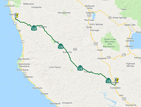 From Route 1 near the mouth of the Navarro River to Route 101 near Cloverdale.
 Post 1964 Signage History
As defined in 1963, this segment was "(a) The mouth of the Navarro River to Route 101 near Cloverdale via McDonald." Later in 1963, Chapter 1698 removed "via McDonald"
In 1994, Chapter 1220 relaxed the origin: "(a) Route 1 near the mouth of the Navarro River to Route 101 near Cloverdale."
 Pre 1964 Signage History
This segment was LRN 48, defined in 1919. It was originally signed as signed Route 28, and in 1952 was renumbered as signed Route 128 (permitting the route around Lake Tahoe to be numbered as Route 28 in coordination with Nevada 28. Between McDonald and US 101, this was originally part of LRN 1, but became part of LRN 48 in 1935 when LRN 1 was moved. Route 128 was not an original state signed route (although Route 28 was).
The LRN 48 between the Navarro River to LRN 1 (US 101) began as the
McDonald-to-the-Sea Highway. LRN 48 essentially was an adoption of
the existing Anderson Valley Trail that had long been in use. This
trail appears on 1917 CSAA maps running from Albion to McDonald. The
Anderson Valley Trail differed from the planned route of the
McDonald-to-the-Sea Highway as it utilized higher terrain west of Wendling
as opposed to following the Navarro River. It shows as a state highway in
1920 state highway maps, reflecting the 1919 adoption. Starting in 1925,
work was begun to bring the route to state standards. By 1928, major
improvements were in process to straighten the road; the existing road was
in a poor state of repair with many sections ungraded, and numerous poorly
designed wooden bridges. Work continued to improve road quality
through 1930. See the linked Gribblenation blog for more details,
including links to maps and pictures.
(Source: Gribblenation Blog (Tom Fearer), “California State Route 128”, March 2021)
In 1934, US 101 in Cloverdale was realigned off Mountain House Road to an
alignment along the Russian River. This resulted in LRN 48 being extended
along former LRN 1 from McDonald to Cloverdale in 1934, a change made
legislatively in 1935.
(Source: Gribblenation Blog (Tom Fearer), “California State Route 128”, March 2021)
 In 1961, the CHC considered adoption of a freeway routing
for the relocation of 8.9 mi of Route 128 (Cloverdale to Mendocino Coast
Road) in Mendocino County between 0.5 mi E of Lazy Creek and Anderson
Creek, W of Boonville. The recommended route follows a more direct
alignment along the general course of the existing highway. The
recommended route is to the N of the present road from E of Lazy Creek to
Indian Creek State Park, slightly S of it for about a mile, then again
just N of the highway to Anderson Creek. The recommended routing is known
as "FA", as it combines route F between Lazy Creek and Philo and route A
between Philo and Anderson Creek. Note that although the freeway routing
was adopted, it has not been constructed as of 2023.
In 1961, the CHC considered adoption of a freeway routing
for the relocation of 8.9 mi of Route 128 (Cloverdale to Mendocino Coast
Road) in Mendocino County between 0.5 mi E of Lazy Creek and Anderson
Creek, W of Boonville. The recommended route follows a more direct
alignment along the general course of the existing highway. The
recommended route is to the N of the present road from E of Lazy Creek to
Indian Creek State Park, slightly S of it for about a mile, then again
just N of the highway to Anderson Creek. The recommended routing is known
as "FA", as it combines route F between Lazy Creek and Philo and route A
between Philo and Anderson Creek. Note that although the freeway routing
was adopted, it has not been constructed as of 2023.
(Source: Cloverdale newspaper, 11/2/1961 via Joel Windmiller,
2/16/2023)
 Status
In October 2018, it was reported that SB1 funding includes a project to
revamp a bridge the Anderson Creek Bridge on Route 128 (MEN 028.29, Bridge
10-0132) in the town of Boonville in Mendocino County.
(Source: Redheaded Blackbird, 10/2/2018)
In June 2011, the CTC approved $9.9 million to repave about 24 miles of Route 128 from near Boonville (~ MEN 28.755) south to the Sonoma County line (~ MEN 50.886/SON 0.0).
In December 2011, the CTC approved for future consideration of funding a project in Mendocino County that will repair a segment of roadway and the adjacent slope on Route 128, from Shearing Creek (~ MEN 34.527) to 0.7 mile west of Maple Creek Bridge (~ MEN 35.45), near Boonville. The project is programmed in the 2010 State Highway Operation and Protection Program (SHOPP). The total estimated project cost is $16,318,000 for capital and support. Construction is estimated to begin in Fiscal Year 2012-13. The scope, as described for the preferred alternative, is consistent with the project scope programmed by the Commission in the 2010 SHOPP. A copy of the MND has been provided to Commission staff. The project will mitigate potential impacts to riparian and waters of the U.S to a less than significant level. Potential impacts to wetlands in the project area will be mitigated by replacing impacted wetlands at a 1:1 ratio. Environmentally Sensitive Area (ESA) fencing will also be used in appropriate areas. Water quality impacts will be mitigated through implementation of Best Management Practices (BMP).
 Freeway
[SHC 253.6] Entire portion. Added to the Freeway and Expressway system in 1959.
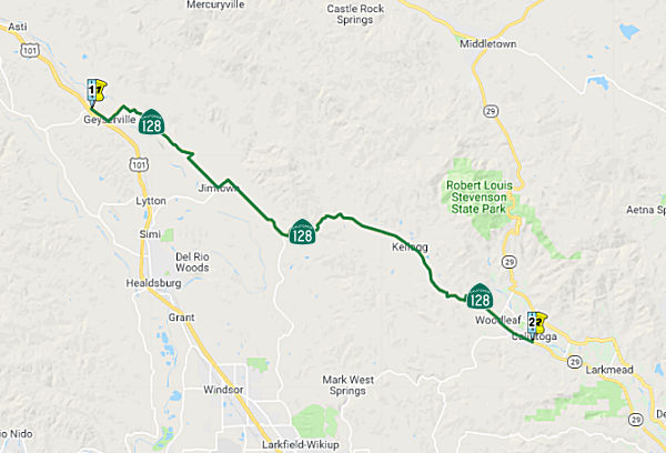 From Route 101 to Route 29 in Calistoga.
Post 1964 Signage HistoryIn 1963, this segment was defined as "(b) Route 101 near Geyserville to Route 29 near Calistoga."
In 1965, Chapter 1371 changed the origin to be "(b) Route 101 near
Geyserville..."
In 1990, Chapter 1187 clarified the terminus: "...to Route 29 near
in Calistoga."
Pre 1964 Signage HistoryNote that the portion between Cloverdale (originally McDonald) and Geyserville was part of US 101 and cosigned with US 101.
This segment was LRN 103, defined in 1933. It was originally signed as signed Route 28, and in 1952 was renumbered as signed Route 128 (permitting the route around Lake Tahoe to be numbered as Route 28 in coordination with Nevada 28. Route 128 was not an original state signed route (although Route 28 was).
There were once plans for a bypass of St. Helena. The Napa Valley
Register had a good article detailing the history:
(Source: St. Helena Star/Napa Valley Register, 9/6/2022)
In 1958, the Redwood Empire Association urged Napa
County supervisors to submit highway projects in response to the
Intercounty Master Schedule of Official Highway Recommendations to the
California Highway Commission. Caltrans held a public hearing on the St.
Helena bypass on Oct. 20, 1958, in the St. Helena High School auditorium.
The sudden turn of events started when the state contacted Mayor Louis
Stralla (who believed the project was not a priority for the state) to
request a hearing. It was expected that the freeway would leave the
existing right of way at Whitehall Lane, running northeast of St. Helena
and rejoining the old route at Bale Lane. For two years, locals debated
where the access roads and interchanges should be. The St. Helena Planning
Commission recommended Pope Street and Fulton Lane as connectors. The St.
Helena Chamber of Commerce pushed Dowdell Lane as the connector, then
changed its stance and recommended Mills Lane. It also wanted the route to
be east of the sewage treatment plant (then located at Hunt and Starr
avenues) to avoid dividing the town, and to enclose a future development
area. The extension of Deer Park Road across the valley was planned, so
that would be the northern interchange of the freeway.
(Source: St. Helena Star/Napa Valley Register, 9/6/2022)
In January 1960, there were updates presented on the
route. The proposed route at that time was a 9-mile bypass from half a
mile south of Rutherford to 3.1 miles north of St. Helena. Two of the
alternate routes showed a cloverleaf interchange on Pope Street. The
easternmost route would pass behind Charles Krug Winery — cutting
the vineyard in two — and rejoin the old highway at Bale Lane. An
alternate western route would leave Main Street at the elm tunnel,
paralleling the trees and then running eastward. Caltrans displayed maps
showing how much traffic would increase between 1956 and 1980. The daily
summer weekday vehicle count was 5,700 and was projected to increase to
8,600. Construction of the new freeway was prediced to be five years away;
locals wouldn't know the route chosen until six months or less before
construction began. The least costly route would cost $5.9 million.
(Source: St. Helena Star/Napa Valley Register, 9/6/2022)
The response centered on on the loss of vineyard land.
The general agreement was that vineyards must be saved. The California
Chamber of Commerce wanted routes to stay as close to downtowns as
possible so visitors would patronize local business. The plan was that
after a 30-day public comment period, Caltrans would decide the route and
obtain freeway agreements with property owners. In March 1960, state
highway engineers recommended a route that would have paralleled the
existing highway until veering off at Manley Lane a half mile to the east
until it reached Ritchie Creek at Bale Lane. This distance of 9.1 miles
was lower in cost and disturbed less land than other alternatives, but
still cost $5.1 million. The highway would be part of the California
Freeway and Expressways System. This route was adopted by Caltrans in
April 1960.
(Source: St. Helena Star/Napa Valley Register, 9/6/2022)
In June 1960, another Caltrans hearing was held. At the hearing,
vineyardists voiced vehement opposition. Many preferred the Silverado
Trail route, while others preferred whatever route was farthest from their
properties. Favoring a more westerly route were Christian Brothers
(Brother Timothy) and Charles Krug Winery (Peter Mondavi). Beringer (Roy
Raymond and Otto Beringer) favored the recommended route. Paul and Virgil
Galleron protested that it would bisect their vineyard. Robert Mondavi of
Charles Krug Winery submitted a petition with 300 signatures demanding
deferral of a final decision by Caltrans on the route. Some criticized
locals for not fighting more forcefully. Geddes got the final adoption of
the bypass route deferred until more study was made. No action was to be
taken pending consultation between Geddes and the California Highway
Commission. Funds would not be allocated until final adoption of the
route.
(Source: St. Helena Star/Napa Valley Register, 9/6/2022)
The St. Helena City Council wrote to Caltrans urging
postponement of final adoption of the route, but Caltrans approved the
controversial route on a 5-2 vote. Council members met in January 1961
with Caltrans engineers on interchanges and approaches for the bypass of
town. Mills Lane was viewed as better for an interchange instead of Pope
Street because a new bridge was planned there to replace the Pope Street
bridge across the Napa River. Work on surveying the St. Helena freeway
bypass continued in March 1961, with aerial mapping and survey stakes
along the present highway. No target date for beginning construction,
which depended on gasoline tax funds, had been released. Napa County
supervisors approved the freeway agreement in April, covering Route 29
between 2 miles north of Yountville and 0.2 mile north of Ritchie Creek at
Bale Lane. In favor were supervisors Clark, Eby and Caiocca; Dickinson and
Fagiani were absent. Planning commissioners met with Caltrans engineers
again in December to discuss access routes to the freeway. Mills Lane was
the site for an 86-foot-wide access road to the bypass. The city wanted to
form a four-way intersection with Grayson, Main and Mills Lane. Other
access roads were planned at Pratt Avenue and Deer Park Road.
(Source: St. Helena Star/Napa Valley Register, 9/6/2022)
In mid-1962 Caltrans budgeted $1.8 million for
construction and rights of way in Napa County. The Redwood Empire
Association continued to lobby Sacramento for new highways. Recommended
for Napa County were survey and design funds for construction of the
freeway between Rutherford and Ritchie Creek, particularly bypassing St.
Helena. Throughout 1963 the four-lane highway was debated and discussed by
officials from Sacramento on down to St. Helena citizens. In August, the
City Council set another study session on the freeway access road, which
the city wanted to be at Mills Lane. There were rumors that the entire
bypass route through St. Helena might be reviewed. The state considered
the matter to be settled with final adoption of the bypass in September
1960, but surveys, designs and rights of way were not done for the
Rutherford-to-Ritchie Creek segment. By the end of 1963, the freeway route
was determined and agreements were signed with all agencies concerned.
(Source: St. Helena Star/Napa Valley Register, 9/6/2022)
In 1965, St. Helena's Chamber of Commerce told Napa
County planners that the freeway plan should be re-examined without delay.
The plan was now five years old and needed to be revised and
revisited. There were numerous campaigns to kill the bypass. In
early 1967, Allen Hart of Caltrans informed the St. Helena Rotary Club
there would be no freeway up the valley for at least 10 to 12 years. There
simply wouldn't be enough money and people could forget about it. The
freeway would not be built until people demanded it or the needs were so
great that it must be built. Most road funds were routed to Southern
California, but the highway between St. Helena and Rutherford would be
repaved.
(Source: St. Helena Star/Napa Valley Register, 9/6/2022)
By May 1968, Napa County supervisors formally requested
that Caltrans to cancel plans for a freeway north of Yountville. The
reason was that the Napa County Agricultural Preserve ordinance was
approved and went into effect on Nov. 11, 1968, protecting 24,000 acres of
farmland against development.
(Source: St. Helena Star/Napa Valley Register, 9/6/2022)
StatusRobert Cruickshank noted that, on the road leading to the River Rock Casino (~ SON 8.221) (off of Route 128 in this area, known as the Alexander Valley) is a shield marking the road as Indian Rte 93.
In November 2011, it was reported that Caltrans announced completion of two new bridges on Route 128 between Healdsburg and Calistoga. The Maacama Creek (~ SON 017.25) and Redwood Creek (~ SON 021.78) bridges, which had been under construction since summer 2010, are wider than the bridges they replaced. Total cost for both new bridges was $7 million.
Freeway[SHC 253.6] Entire portion. Added to the Freeway and Expressway system in 1959.
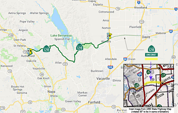 From Route 29 near Rutherford to Route 113 near Davis via Sage Canyon.
Post 1964 Signage History Unconstructed as state highway from Route 113 to Route 505,
although the planned route exists as Yolo County Sign Route E6. This segment is unchanged
from 1963. Note: The 2002 Traversable Highways Report indicates this
segment will be considered for assumption of maintenance after a two-mile
section of Russell Blvd just east of Route 505 is reconstructed. Yolo
County will improve the roadway as funds permit. It is unclear if this
ever happened.
Unconstructed as state highway from Route 113 to Route 505,
although the planned route exists as Yolo County Sign Route E6. This segment is unchanged
from 1963. Note: The 2002 Traversable Highways Report indicates this
segment will be considered for assumption of maintenance after a two-mile
section of Russell Blvd just east of Route 505 is reconstructed. Yolo
County will improve the roadway as funds permit. It is unclear if this
ever happened.
The 2013 Traversable Highways report noted the closest routing is County Roads 32, 93A and 31. District 3 has not receive a request from Yolo County and the City of Winters to discuss possible adoption of an alignment between the current end of Route 128 at I-505 in the City of Winters and Route 113 in the City of Davis.. The current County Roads do not appear to meet State Standards and new alignment appears to be infeasible.
Pre 1964 Signage HistoryThis was LRN 102 between Rutherford and the junction with Route 37 (present-day Route 121; Steele Canyon Road, defined in 1933). It was LRN 6 (1933 extension) between Steele Canyon Road and I-505, and LRN 6 (1959 extension) from I-505 to Route 113 (former Alternate US 40). It was originally signed as signed Route 28, and in 1952 was renumbered as signed Route 128 (permitting the route around Lake Tahoe to be numbered as Route 28 in coordination with Nevada 28. It may also have been signed as part of Alternate US 40. Route 128 was not an original state signed route (although Route 28 was).
Route 28 (Future Route 128)/LRN 102 saw a minor realignment just E of
Rutherford when Conn Creek Dam was completed in 1948 and formed Lake
Hennessey (~ NAP 9.035). The creation of Lake Hennessey shifted the
routing slightly southward and uphill from Conn Creek Dam east towards
Sage Creek.
(Source: Gribblenation Blog (Tom Fearer), “California State Route 128”, March 2021)
Another realignment occurred around 1955, where Route 128/LRN 6 required
realignment at the site of the 270 foot high Monticello Dam (~ NAP
34.248). The Monticello Dam project broke ground in 1953 along Putah
Creek with the end goal of creating the Lake Berryessa Reservoir.
The construction of Monticello Dam required both Route 37 and Route 128 be
realigned to the south of the planned Lake Berryessa. Route 128/LRN 6 was heavily impacted by the Monticello Dam project as it
followed Putah Creek from the outskirts of the Town of Monticello east to
the Yolo County Line. Additionally the Town of Monticello in
Berryessa Valley was slated to be inundated by 100 feet of water. In
total 16.3 miles of new highway was constructed. The realigned Route 128
would make a brief swing into Solano County near the site of Monticello
Dam. Monticello Dam was topped out during November of 1957 but
Lake Berryessa wouldn't fill to capacity until April of 1963.
(Source: Gribblenation Blog (Tom Fearer), “California State Route 128”, March 2021)
For more details on the Putah Creek Bridge of Monticello, which was
submerged when the Monticello Dam was filled, see the Gribblenation Blog "The Putah Creek Bridge of Monticello (former California State Route 28)". The Putah Creek Bridge was a masonry structure constructed during 1896 by Napa County to serve the community of
Monticello. The Putah Creek Bridge would be annexed into the State
Highway System in 1933 when LRN 6 was extended from Woodland Junction to
Napa. The Putah Creek Bridge was a component of the original Sign
Route 28 from 1934-1952. The span briefly became part of Sign Route 128 in 1953 until the highway was relocated as part of the Monticello Dam
project in 1955. Today, the Putah Creek Bridge sits at the bottom of
the Lake Berryessa reservoir and is accessible to divers. The Monticello
Dam project broke ground in 1953 along Putah Creek with the end goal of
creating the Lake Berryessa Reservoir. The construction of
Monticello Dam required both Sign Route 37 and Sign Route 128 be realigned
to the south of the planned Lake Berryessa. Sign Route 128/LRN 6 in
particular was heavily impacted by the Monticello Dam project as it
followed Putah Creek from the outskirts of the Town of Monticello east to
the Yolo County Line. Additionally, the Town of Monticello in
Berryessa Valley was slated to be inundated by 100 feet of water. In
total 16.3 miles of new highway was slated to be constructed, which was
mostly the realigned Sign Route 128. The realigned Sign Route 128
would make a brief swing into Solano County near the site of Monticello
Dam. Monticello Dam was topped out during November of 1957,
but Lake Berryessa didn't fill to capacity until April of 1963.
(Source: Gribblenation Blog (Tom Fearer), "The Putah Creek Bridge of Monticello (former California State Route 28)", January 2024)
Prior to the 1940s, Route 28 (future Route 128) was signed to US 40 near
Davis via Russell Road east of Winters. Route 28 east of Winters to US 40
near Davis last appears on the 1938 Division of Highways State Map. At
that time, Russell from Road 98/Pedrick (now County Sign Route E7) was the Lincoln
Highway/US 40, so this was a straight connection of Route 28 (Route 128)
to US 40. But Russell Road was just a farm road between Winters and Davis.
Projected development in that area and the construction of the Monticello
Dam and Lake Berryessa, and all the recreation opportunities that went
with it, suggested the need for better a better regional road. In
the late 1960s Davis was already trying to thwart through traffic with
cul-de-sacs and greenbelt parks and encouraging bicycling. Coupled
with the narrow, two lane railroad underpass between downtown and
US40/I-80, the solution was to create a bypass route around town instead
of plowing through it. As such, the county constructed Road 93A road
was constructed to Road 31 (County Sign Route E6), which became Covell E of Route 113,
which then curves onto Mace Blvd. on the east side of Davis. This was
constructed circa 1969-70. With that project and its intent to
provide a northern route around Davis, the need to straighten out Russell
pretty much went away.
(Source: Gribblenation Blog (Tom Fearer), “California State Route 128”, March 2021; HeyNow415 on AARoads, “Re: CA 128”, 3/17/2021)
StatusThe 2018 STIP, approved at the CTC March 2018 meeting, appears to adjust the funding for PPNO 2130M, Rt 128/Petrified Forest Rd Intersection Improv., from $425K to $475K, and delay construction to FY19-20. This project is in Calistoga at PM NAP 3.5/3.7. Install traffic signal and various ADA compliant pedestrian improvements at the Route 128/Petrified Forest Road Intersection.
In March 2019, it was reported that Napa County was planning to start
construction in Spring 2018 on the Conn Creek bridge (NAP R007.41, Bridge
21-0021, constructed in 1973) replacement on busy Silverado Trail. The
Metropolitan Transportation Commission’s Vital Signs report says
13.9 percent of the bridge-and-overpass deck area in Napa County is
“structurally deficient.” That is the worst rate among nine
Bay Area counties and above the region’s 6.7 percent. In the case of
the Conn Creek bridge along Silverado Trail east of Rutherford, the remedy
goes far beyond a patch job. The existing bridge has been affected by
scouring of the creek bed, causing settlement and damage to its structure,
and it is not possible to repair the damaged components. Caltrans plans to
removed the early 1970s bridge and build a new one at a cost of $8.3
million. Construction is to begin in spring 2019 and last into 2020.
Caltrans plans to demolish and reconstruct the bridge in two sections, so
one side is available to carry traffic while work goes on. One lane will
be open in each direction during most of the construction period, except
during temporary closures, Mara said. There will be no shoulders.
(Source: Napa Valley Register, 3/11/2019)
Hopper Slough Bridge (04-Napa-128 PM 5.002/5.242)
 The following project was included in the final adopted 2018 SHOPP in March 2018: PPNO 1451C. 04-Napa-128 5.1. Route 128
Near Rutherford, at Hopper Slough Bridge No. 20-0019. Replace bridge.
Begin Con: 12/1/2022. Total Project Cost: $15,660K.
The following project was included in the final adopted 2018 SHOPP in March 2018: PPNO 1451C. 04-Napa-128 5.1. Route 128
Near Rutherford, at Hopper Slough Bridge No. 20-0019. Replace bridge.
Begin Con: 12/1/2022. Total Project Cost: $15,660K.
The 2020 SHOPP, approved in May 2020, included the
following Bridge Restoration item of interest (carried over from the 2018
SHOPP): 04-Napa-128 PM 5.1 PPNO 1451C Proj ID 0416000038 EA 4J830. Route 128 near Rutherford, at Hopper Slough Bridge No. 21-0019. Replace bridge.
Programmed in FY21-22, with construction scheduled to start in January
2023. Total project cost is $15,660K, with $9,378K being capital (const
and right of way) and $6,282K being support (engineering, environmental,
etc.).
(Source: 2020 Approved SHOPP a/o May 2020)
In January 2021, the CTC approved a supplemental
allocation of $1,726,000 in Capital Outlay Support (COS), for 04-NAP-128
5.1 (PPNO 04-1451C; ProjID 0416000038; EA 4J830) “Route 128 Near
Rutherford, at Hopper Slough Bridge No. 21-0019. Outcome/Output:
Replace bridge.” to complete the Project Approval and Environmental
Document (PA&ED) project phase. The original PA&ED allocation was
$2,074,000, making the revised PA&ED allocation $3,452,000. This
project is located on Route 128 near the City of St. Helena in Napa
County. The project will replace the existing Hopper Slough
Bridge. The original replacement bridge was planned to be a
single-span bridge supported by deep foundations. Upon further analysis,
and taking into consideration potential scour at the bridge abutments and
mid-stream bridge support, and constraints against construction in the
stream, it was recommended that the Department should refrain from placing
the bridge support in the middle of the stream to eliminate bridge scour
risks, and should consider placing the abutments far from the banks of the
creek to avoid constricting the creek flow during flood seasons which
would result in bridge abutment wash-out. In the Fall of 2020, the
Department decided to change the bridge design to be a three-span bridge
design, with a middle portion spanning over the entire creek would
eliminates foundation work in the creek. This design concept would also
eliminate placing any abutment embankments in the creek. This project was
programmed into the 2018 SHOPP for delivery in Fiscal Year (FY) 2021-22.
Funding for the PA&ED phase was allocated in March 2018 for
$2,074,000. At this time, a total of $1,948,000 of the budget has
been expended, and as of December 2020, 45 percent of the PA&ED phase
work has been completed. The remaining work to complete the PA&ED
phase include conducting several tasks that were performed earlier for the
single-span bridge, these tasks must be repeated for the larger footprint,
three-span bridge due to change in geometry and locations of the bridge
supports. The remaining budget of $126,000 is not adequate to
complete the PA&ED phase by the planned completion date of May
2022. The amount needed to provide resources to complete the phase
is $1,726,000. The primary reason for the PA&ED cost increase is the
change in the bridge design to eliminate the risks of bridge hydraulic
scour and abutment wash-out, provide un-obstructed area for flood level
flow, and avoid construction risks in the stream bed. Additional efforts
will be necessary to evaluate and minimize environmental impacts of the
new bridge footprint, coordinate with resource and permitting agencies
(California Department of Fish and Wildlife; Regional Water Quality
Control Board, U.S. Army Corps of Engineers, and U.S. Fish and Wildlife
Service), and conduct public engagement regarding bridge aesthetics and
traffic closures and detours. The project team considered and recommended
a more appropriate longer three-span bridge, which eliminates abutments in
the creek, provides a larger opening under the bridge for higher flows,
and reduces risks of scour and washout.
(Source: January 2021 CTC Minutes, Agenda Item
2.5e.(1))
In March 2021, the CTC amended this project in the
SHOPP: (1d) #15. 04-Nap-128 5.1 PPNO 1451C ProjID 0416000038 EA
4J830. Route 128 Near Rutherford, at Hopper Slough Bridge No. 21-0019.
Replace bridge. This project was amended to adjust costs. Increase in
construction support (from $2,014K to $3,900K) and capital (from $7,864K
to $12,200K) is due to significant design change from a single-span to a
three- span bridge with a longer structure and changed foundation type to
address poor soil conditions. The proposed changes require additional
environmental work, delaying the completion of PA&ED phase, thus
delaying the project delivery. Revised total: $21,882K. Revised
completion: FY23-24.
(Source: March 2021 CTC Agenda, Agenda Item
2.1a.(1d) #15)
In August 2022, the CTC approved this project for
future consideration of funding: Hopper Slough Bridge Replacement
Project (04-Nap-128, PM 5.12). Replace existing Hopper Slough
Bridge with new bridge of same vehicular capacity. Replace existing
culvert with a 6-foot by 6-foot precast reinforced box culvert, install
retaining walls, and update guardrails on Route 128, in Napa County. (PPNO
1451C). The project is located on Route 128 between postmile 5.002 and
5.242, in Napa County. The Department proposes to replace the existing
Hopper Slough Bridge with a new bridge with the same vehicular capacity.
The project would replace the existing culvert with a precast reinforced
box culvert. The alignment of the roadway would remain the same and
the profile would be 2.8 feet higher than the existing bridge.
Additionally retaining walls would be installed and guardrails would be
updated. This project is currently programmed in the 2022 State Highway
Operation and Protection Program (SHOPP) f or a project total of
$21,882,000, which includes Right of Way (capital) and Construction
(capital and support). Construction is estimated to begin in 2023-24. The
scope, as described for the preferred alternative, is consistent with the
project scope as programmed by the Commission in the 2022 SHOPP.
(Source: August 2022 CTC Agenda, Agenda Item
2.2c.(5))
In August 2022, the CTC approved the following
pre-construction phase allocation: $2,355,000. 04-Nap-128 5.1. PPNO
04-1451C; ProjID 0416000038; EA 4J830. Route 128 Near Rutherford, at
Hopper Slough Bridge № 21-0019. Replace bridge. Programmed (Actual)
Allocation: FY23-24 PS&E $1,988,000 ($2,355,000). Future consideration
of funding approved under Resolution E-22-73; August 2022. Fourteen month
time extension for PS&E approved under Waiver 21-59; June 2021.
(Source: August 2022 CTC Agenda, Agenda Item 2.5b.(2b) #10)
Capell Creek Bridge (04-Nap-128, PM 19.7/20.7)
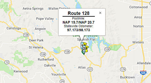 In August 2016, the CTC approved for future consideration of funding a project on Route 128
(04-Nap-128, PM 19.7/20.7) in Napa County that will replace the existing
Capell Creek Bridge on Route 128 near the community of Rutherford. The
project is programmed in the 2016 State Highway Operation and Protection
Program. The total programmed amount is $18,225,000 for capital and
support. Construction is estimated to begin in Fiscal Year 2018-19. The
scope, as described for the preferred alternative, is consistent with the
project scope programmed by the Commission in the 2016 State Highway
Operation and Protection Program.
In August 2016, the CTC approved for future consideration of funding a project on Route 128
(04-Nap-128, PM 19.7/20.7) in Napa County that will replace the existing
Capell Creek Bridge on Route 128 near the community of Rutherford. The
project is programmed in the 2016 State Highway Operation and Protection
Program. The total programmed amount is $18,225,000 for capital and
support. Construction is estimated to begin in Fiscal Year 2018-19. The
scope, as described for the preferred alternative, is consistent with the
project scope programmed by the Commission in the 2016 State Highway
Operation and Protection Program.
In December 2018, the CTC approved an allocation request for $20,116,000 for the State Highway Operation Protection Program (SHOPP) Bridge Preservation project (PPNO 0830B) on Route 128 in Napa County. This is an increase of 22% over the Capitol allocated amount, and 80% over the Support allocated amount. This is a Bridge Rehabilitation project to replace the existing structurally deficient Capell Creek Bridge and install horizontal drains on Route 128, in unincorporated Napa County, approximately 10 miles from the community of Rutherford. Route 128 is a north-south, two-lane, undivided conventional highway. The bridge is located on an active landslide; earth movement in the adjacent hillside undermines the Capell Creek Bridge’s abutment and foundation. Past installation of horizontal drains and polystyrene cushions at the project site did not resolve the slide, nor prevent further damage to the bridge, and the bridge is now beyond repair.
The proposed replacement bridge is approximately 44 feet wide and 242 feet long, with 3 spans on the existing alignment. The bridge will be widened to provide for standard lane and shoulder widths. Minor roadway widening will occur both to the north and south of the new bridge to taper the proposed bridge roadbed to the existing roadbed and provide for access to the temporary detour bridge. The existing reinforced concrete/steel girder bridge will be demolished to construct a new precast/prestressed I-girder bridge with cast-in-place/reinforced concrete bents on the existing alignment. To minimize traffic impacts, the new bridge will require construction of a temporary detour bridge immediately east of the existing bridge. In addition to the bridge replacement, 13 new horizontal drains will be installed along Capell Creek to stabilize the hillside.
The project was programmed in the 2016 SHOPP for a
Construction allocation in Fiscal Year 2017-18; which is from July 1, 2017
to June 30, 2018. If the Department does not obtain an allocation during
this programmed fiscal year, a time extension for the Construction
Allocation is required to keep the project programming active. On June 28,
2018, the Commission approved an 18-month time extension for this project
that will expire in December 2019. The Construction Capital cost increase
is due to required design changes to the bridge foundations, construction
staging changes, increased duration of project working days, and
unexpected environmental permit requirements that resulted in a need to
split the mitigation and monitoring scope into a separate follow-up
project. The estimated Construction Support cost increase is due to
additional working days to accommodate construction staging and to address
environmental permit requirements.
(Source: December 2018 CTC Minutes, Agenda Item 2.5d(1))
In January 2021, the CTC approved Caltrans' request for
an additional $1,500,000 in construction support cost for 04-Nap-128
20.1/20.4 PPNO 04-0830B ProjID 0413000051 EA 4G840 Route 128 Near Napa, at
Capell Creek Bridge No. 21-0078. Outcome/Output: Rehabilitate bridge.
Total revised amount $6,837,000. The existing three-span Capell Creek
bridge was built in 1956; it is 32 feet wide and 205 feet long. It
was impacted by a slow-moving landslide that caused one of its abutments
to move southerly toward the other abutment. The landslide has been
under continuous monitoring for many years, and the ongoing earth movement
has led to the deterioration of the bridge supports and compromised the
bridge structural integrity. Caltrans analyzed several options to overcome
the on-going earth movement and concluded that the only solution was to
replace the bridge with a new, three-span bridge, that is 44 feet wide and
242 feet long. In February 2019, the project contract was awarded for
$13,539,000 in construction capital with a construction support budget in
the amount of $4,670,000. Currently, the remaining project budget
consists of $826,000 in construction support; which includes $667,000 in
G-12 funds, and $5,297,000 in construction capital. Construction for the
project began in May 2019 with 750 working days, including a 250-day Plant
Establishment Period (PEP), to be completed in two construction seasons.
Currently, the project is 69 percent complete, and with 136 remaining
working days, the project construction activities are expected to be
completed by July 2021, however, to allow adequate period for plant
establishment, the project contract is planned is planned to be completed
and accepted by December 2022. The project has experienced delays and work
stoppages due to two recent major wildfires that affected the construction
site and critical path work. Also contributed to delays were environmental
constraints associated with the bridge demolitions, modification of the
access road, and approval of temporary/permanent bat housing, and
extensive efforts to provide quality assurance on the use of an innovative
temporary detour bridge. The primary reasons for the increase in
construction support funds are to provide adequate resources and staff to
perform the inspection and contract administration tasks to complete the
construction contract. Additional efforts were necessary to address
impacts from wildfires, technical requirements, environmental permit
conditions, constructability, and material availability and certification
as follows: (1) Temporary Bridge (Prefabricated Modular Steel Truss
Bridge) — a 230 foot long prefabricated Temporary Modular Steel
Truss Bridge; a new contract item which was never in the
Department’s historical pricing database prior to this project; (2)
Wildfire Work Stoppages — the LNU Lightening Complex Fire and the
Glass Fire; (3) Cement and fly ash shortages; (4) Access Road — the
original contract included a 10-foot-wide access road that was
insufficient for mobilization of material and equipment to construct the
bridge foundations, and so a minimum width of 25 feet was needed to
accommodate the large crane and drill rig to install Cast In Drilled Hole
piling, 12 foot diameter permanent steel casings and 15.5 foot diameter
isolation casing… which involved removal of additional vegetation
adjacent to PG&E and AT&T aerial facilities, as well as
environmental permits with regulatory agencies; (5) Falsework for
Bent/Pier Cap; (6) Bridge Demolition approach for creek protection; and
(6) Bat Housing.
(Source: January 2021 CTC Agenda, Agenda Item
2.5e.(6))
Freeway[SHC 253.6] From Route 121 to Route 113 near Davis. Added to the Freeway and Expressway system in 1959.
 Scenic Route
In April 2019, it was reported that legislation that would make Route 128
a “Scenic Highway” is nearer passage following action by the
California Assembly. AB 998, sponsored by Assemblywoman Cecilia
Aguiar-Curry, passed the Assembly floor with a bipartisan vote of 75-0.
This bill makes Route 128 eligible to be named as a “Scenic
Highway,” which will increase local economic activity in the North
Bay region and bring new appreciation to the beauty of the route. Route 128 is roughly 140 miles long and runs through Yolo, Napa, Sonoma, and
Mendocino counties. The highway is nestled against coastal mountains and
passes through world class wineries, Michelin Star restaurants, rustic
spas and resorts, historic sites, state and national parks, and scenic
landscapes. Note that this bill will just add it to the Scenic Highway
System. There are additional policies within Caltrans that must be
satisfied before signs go up.
(Source: �� Mercury News, 4/24/2019)
Route 128 was added to the legislative scenic highway system by AB 998, Chapter 104, Statutes of 2019, 7/12/2019.
 Interregional Route
[SHC 164.16] Entire route.
 Other WWW Links
 Statistics
Overall statistics for Route 128:
 Pre-1964 Legislative Route
In 1933, Chapter 767 added the route "[LRN 31] to Death Valley and connection to the California-Nevada State Line" to the highway system. In 1935, the portion from [LRN 31] to Death Valley was added as LRN 127. LRN 128 was added to the highway code with the following routing:
[LRN 127] to the Nevada State Line
This routing remained unchanged until the 1963 renumbering. It ran from the Route 190/Route 127 junction to the Nevada state line, and is part of present day Route 127.
© 1996-2020 Daniel P. Faigin.
Maintained by: Daniel P. Faigin
<webmaster@cahighways.org>.
 Route 127
 Route 129