
 California Highways:
Click here for a key to the symbols used. An explanation of acronyms may be found at the bottom of the page.
 Routing
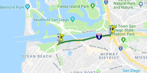 From Sunset Cliffs Boulevard to Route 5 in San Diego.
 Post 1964 Signage History
This was formerly Route 109; it was transferred to Route 8 in 1972 by Chapter 1216. See below for 1934-1963 signed Route 8.
 Pre 1964 Signage History
This was LRN 286. It was added to the state highway system in 1959 by Chapter 1062.
 Naming
This portion of Route 8 is named the "Ocean Beach Freeway". It was named by Assembly Concurrent Resolution 117, Chapter 233, in 1968.
 Status
Postmile Note: Owing to the status of this segment as former Route 109, the postmiles are distinct from the rest of I-8, being L postmiles. There are also some T postmiles, so this segment runs from 008 SD T0.407 to approx 008 SD L2.367.
In January 2021, it was reported that, after three years of work on the
new West Mission Bay Bridge (~ SD L1.244), the project is halfway
finished. With the cutting of ribbon in January 2021, San Diego Mayor Todd
Gloria and Council President Jennifer Campbell unveiled what the new West
Mission Bay Bridge looks like. Though the project isn’t completed,
motorists will be allowed to drive on the finished portion starting
Tuesday evening. As motorists begin using the portion of the new bridge,
crews will begin to safely demolish the old one. Cal Trans Officials say
the old bridge needed to be replaced because of the heavy volume of daily
traffic. Once the project is finished, there will be two new parallel
bridge structures with three lanes going in each direction, north and
south. There will also be a bike path on both bridges, catering to
bicyclists and pedestrians. The roadway will also be widened along Sports
Arena Boulevard, West Mission Bay Drive, and the westbound I-8 off-ramp.
The project is expected to be completed in 2022. Once the old bridge is
demolished, the material will be recycled and reused for other projects.
The old West Mission Bay Drive bridge was built in the early 1950s and
featured only two travel lanes for northbound and southbound traffic.
(Source: ABC 10 News, 1/5/2021)
 Scenic Route
[SHC 263.3] Entire portion.
 Interstate Submissions
Interstate (non-chargable).
 From Route 5 in San Diego to Yuma via El Centro.
Post 1964 Signage HistoryThis segment was added in 1963 by Chapter 385. See below for 1934-1963 signed Route 8.
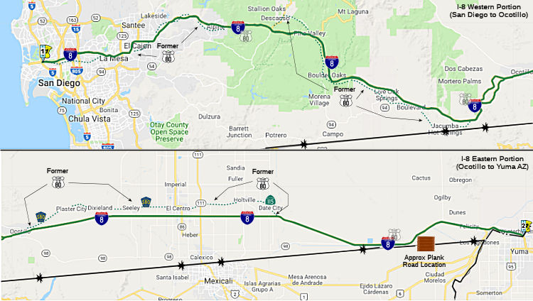
 This is approximately what was previously designated as US 80. The
US 80 designation disappeared on July 1, 1964, when the Route 80
designation was reassigned to what was US 40. US 80 as a route dates back
to at least 1929.
This is approximately what was previously designated as US 80. The
US 80 designation disappeared on July 1, 1964, when the Route 80
designation was reassigned to what was US 40. US 80 as a route dates back
to at least 1929.
When first planned, I-8 was going to end at its intersection with I-5. It
did until 1971, when the Ocean Beach Freeway was renumbered from Route 109
to I-8, which extended I-8 west of I-5. In May 1963, completion of I-8 was
the second highest priority of all road construction in California,
according to the Highway Development Association. East of San Diego, what
had been US 80 was slowly replaced by I-8 as construction took place in
the Imperial Valley. By 1975 the California portion of I-8 was completed,
and the Arizona portion of the interstate was finished in 1977. However,
construction of the bridge over the Colorado River did not finish until
1978.
(Source: Freightways Classic, 5/21/2021)
Michael Ballard has a page that details the history of the segment
between Alpine and Descanso, the plans for a tunnel on US 80 in that area,
and the new construction for I-8 that obviated the need for the tunnel.
See A TUNNEL ON US 80? for more information.
(Source: Southern California Regional Rocks &
Roads "A Tunnel on US 80?")
According to the San Diego Union newspaper in May 1965, the construction
of I-8 through the canyons was “through some of the most rugged,
hottest sections of San Diego and Imperial counties,” in addition to
concern about potential landslides. The highway’s westbound lanes
were built first, and were temporarily used by both directions of traffic
while the old highway was rebuilt as the eastbound lanes. The Los Angeles
Times described the section of roadway east of Mountain Springs in this
way: “Through it the freeway engineers have hacked two separate
roadways not even in sight of each other, but so overpowering in the sheer
magnitude of the cuts through the mountains that it is almost impossible
to believe human beings could have so overpowered hostile nature
…” Site access for the construction crews was very difficult,
and many slopes had to be stabilized. In the summer, temperatures reached
120°F and 4 °F (−16 °C) in winter; wind gusts blew up
to 80 miles per hour.
(Source: Freightways Classic, 5/21/2021)
Note: The current I-8 bridge in Yuma was built in 1978. The old US 80 bridge is now the Business Route 8 bridge, and the old old US 80 bridge is a pedestrian bridge. This bridge, the "Ocean to Ocean Highway" bridge, will be reopened to one-lane traffic in the near future to serve traffic visiting the Quechan Reservation.
Eastbound I-8 follows the alignment of US 80 across Telegraph Pass. Westbound I-8 was constructed on a new alignment. The topography dictated the crossover of the roads, as there was no place to economically place a WB alignment north of the EB roadway. Vestiges of an older US 80 alignment can be seen in the pass west of the Dome Valley TI.
Some interesting information bout I-8: It traverses many different
terrains; it begins very close to the Pacific Ocean, crosses the Colorado
River and runs through two national forests, the Imperial Sand Dunes
Recreation Area and desert terrain. I-8 runs parallel to the All-American
Canal for about 55 miles across the desert, including the Sonoran Desert
National Monument. In some areas of eastern Imperial County the Mexican
border is less than half a mile south of the Interstate. It has the lowest
elevation of any of the interstates; it dips to 52 feet below sea level in
California’s Imperial Valley near El Centro. I-8 also travels
through several mountain passes and its highest elevation is 4,000 feet at
Carpenter Summit. It straddles the line between San Diego and Imperial
counties for a few miles before turning east. When it reaches the Mountain
Springs/In Ko Pah grade, I-8 is routed through two canyons – Devils
Canyon for westbound traffic and In-Ko-Pah Gorge for eastbound traffic
– and it descends 3,000 feet in 11 miles. In places, the median is
over 1.5 miles wide. This section of I-8 experiences high winds in the
canyons, which has led to closure of the road at times. In 1966, the
California Highway Patrol estimated that winds reached 100 miles per hour
in the area.
(Source: Freightways Classic, 5/21/2021)
Pre 1964 Signage History The portion of this segment between San Diego and El Centro was LRN 12, and was added to the state highway system in 1909. It was signed as US 80.
The portion of this segment between El Centro and the Arizona state line was LRN 27, and was added to the state highway
system in 1915. Part of this was realigned in 1972 (Chapter 742) near El
Centro, with a portion becoming Route 115.
In 1912 the first road over the Cuyamaca Mountains
was dedicated. It was narrow and wound through the mountains. In 1926 the
road was paved and opened in 1927. Road remnants were still existent in
the late 20th century. In the early 1930s another road was built to remove
curves and widen lanes. This two-lane road still had numerous switchbacks.
When I-8 was built it was placed atop some of the 1930s roadbed. In 1915,
the Ocean-to-Ocean Bridge across the Colorado River was opened. It was
replaced in 1956 and was used until the I-8 bridge was built.
(Source: Freightways Classic, 5/21/2021)
The origins of I-8 in San Diego go back to 1957 when
the US 80 freeway construction began. US 80 was built east from US 101 to
El Cajon by the early 1960s. US 80 through San Diego was largely complete
when it was renumbered as I-8 in the 1964 state highway renumbering.
(Source: Freightways Classic, 5/21/2021)
A plank road made of pieces of wood that were tied together was the first road across the Imperial Valley to Yuma. These were later replaced by US 80 across California and part of Arizona. Pieces remain just off of I-8 (~ 008 IMP 77.651); this it appears to be actually associated with the earlier Southern National Highway, which created the first all-season southern route across the U.S, between Washington, D.C., and San Diego. The named highway had its origins in the early 1910s, and came into prominence in 1915, predating the Old Spanish Trail by more than eight years. To arouse interest in the Pan-Pacific Exposition of 1915, a cross-country caravan set out from San Diego along the Southern National Highway in November 2, 1915, and reached D.C. in 32 days. See the discussion of former US 80 for more information.
StatusThe SAFETEA-LU act, enacted in August 2005 as the reauthorization of TEA-21, provided the following expenditures on or near this route:
Lane Additions near I-5:
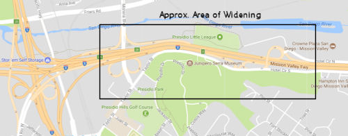 In March 2017, the CTC authorized additional funding for a safety project in
San Diego County in San Diego on westbound I-8 from 0.2 mile west of
Morena Boulevard to 0.1 mile east of Hotel Circle North interchange ramps
(11-SD-8, PM R0.1/2.0). Restripe westbound I-8, add an additional
westbound lane, and improve signage. The project is in the City of San
Diego and will improve safety and reduce collisions by widening and
enhancing striping and signage on westbound I-8 where it approaches
Interstate 5 (I-5). The project is south of the San Diego River and the
San Diego River bike path runs directly north of and parallel to I-8. The
widening will add a westbound lane to I-8 that is supported by a retaining
wall that is about 2,100 feet in length. The project is currently in the
PS&E phase and is about 65% complete. The Department has expended over
$1,967,396 in Support Cost including addressing project scope changes that
were unforeseen in the Project Approval & Environmental Document
(PA&ED) phase. The requested funds are needed to complete the PS&E
phase to address this modified scope. The additional funds are a result of
a significant change in the retaining wall design and to minimize the
impacts of closing an off-ramp during construction of the project.The
project is currently in the PS&E phase and is about 65% complete. The
Department has expended over $1,967,396 in Support Cost including
addressing project scope changes that were unforeseen in the Project
Approval & Environmental Document (PA&ED) phase. The requested
funds are needed to complete the PS&E phase to address this modified
scope. The additional funds are a result of a significant change in the
retaining wall design and to minimize the impacts of closing an off-ramp
during construction of the project. During the PA&ED phase, a Standard
Plan retaining wall (Type 1) was recommended along westbound I-8 to
accommodate the proposed widening. The proposed Type 1 retaining wall was
determined based on the existing boring data from nearby locations. The
use of a Type 1 retaining wall was identified as a risk in the PA&ED
Risk Register, which recommended that geotechnical field investigations be
performed in the PS&E phase. The geotechnical field investigations
revealed soil conditions and a higher ground water table that differed
from the assumed conditions used in the PA&ED phase. Due to the higher
water table, a Type 1 retaining wall that supported the base of the fill
slope was no longer a viable alternative. As such, the Department
evaluated many other special wall type alternatives. After further
analysis, these proposed wall type alternatives were rejected due to the
fact that the soil is highly liquefiable, which increases the chances of
wall failure during a seismic event. Therefore, a Geosynthetically
Reinforced Embankment (GRE) Reinforced Slope was selected to support the
I-8 widening instead of using the Standard Plan Type 1 retaining wall. Due
to the change to the GRE Reinforced Slope, an existing trapezoidal
concrete drainage channel needs to be removed and a new rectangular
channel needs to be designed. This additional effort will increase the
Support Cost for the PS&E phase. The PA&ED phase of the project
estimated an 8 week closure to the I-8 westbound Morena Boulevard off
ramp. During the PS&E phase the design team concluded that the closure
needed to complete the work to realign the ramp to support the widening of
the freeway, would need to be a minimum of 6 months. Shortly thereafter,
an executive constructability team meeting was conducted to review the
project including the potential duration of the ramp closure. The Morena
Boulevard off-ramp provides access to the University of San Diego (USD),
the Morena Business District and the Linda Vista community and a prolonged
closure could cause severe traffic impacts. A revised construction staging
concept was developed to provide an interim connection to the Morena
Boulevard off ramp which will cut the 6-month duration of the closure in
half. This will reduce the severe impacts to the traveling public, USD and
the nearby businesses. During the ramp closure, several detour options
will be available including use of the preceding off-ramp exiting at
Taylor Street. Although the closure of the Morena Boulevard off-ramp was
identified in the PA&ED phase, the additional design effort was needed
to develop the staging concept that incorporates an interim connection to
the Morena Boulevard off ramp. An extensive public outreach effort for the
ramp closure will also be required during both the design and construction
phases.
In March 2017, the CTC authorized additional funding for a safety project in
San Diego County in San Diego on westbound I-8 from 0.2 mile west of
Morena Boulevard to 0.1 mile east of Hotel Circle North interchange ramps
(11-SD-8, PM R0.1/2.0). Restripe westbound I-8, add an additional
westbound lane, and improve signage. The project is in the City of San
Diego and will improve safety and reduce collisions by widening and
enhancing striping and signage on westbound I-8 where it approaches
Interstate 5 (I-5). The project is south of the San Diego River and the
San Diego River bike path runs directly north of and parallel to I-8. The
widening will add a westbound lane to I-8 that is supported by a retaining
wall that is about 2,100 feet in length. The project is currently in the
PS&E phase and is about 65% complete. The Department has expended over
$1,967,396 in Support Cost including addressing project scope changes that
were unforeseen in the Project Approval & Environmental Document
(PA&ED) phase. The requested funds are needed to complete the PS&E
phase to address this modified scope. The additional funds are a result of
a significant change in the retaining wall design and to minimize the
impacts of closing an off-ramp during construction of the project.The
project is currently in the PS&E phase and is about 65% complete. The
Department has expended over $1,967,396 in Support Cost including
addressing project scope changes that were unforeseen in the Project
Approval & Environmental Document (PA&ED) phase. The requested
funds are needed to complete the PS&E phase to address this modified
scope. The additional funds are a result of a significant change in the
retaining wall design and to minimize the impacts of closing an off-ramp
during construction of the project. During the PA&ED phase, a Standard
Plan retaining wall (Type 1) was recommended along westbound I-8 to
accommodate the proposed widening. The proposed Type 1 retaining wall was
determined based on the existing boring data from nearby locations. The
use of a Type 1 retaining wall was identified as a risk in the PA&ED
Risk Register, which recommended that geotechnical field investigations be
performed in the PS&E phase. The geotechnical field investigations
revealed soil conditions and a higher ground water table that differed
from the assumed conditions used in the PA&ED phase. Due to the higher
water table, a Type 1 retaining wall that supported the base of the fill
slope was no longer a viable alternative. As such, the Department
evaluated many other special wall type alternatives. After further
analysis, these proposed wall type alternatives were rejected due to the
fact that the soil is highly liquefiable, which increases the chances of
wall failure during a seismic event. Therefore, a Geosynthetically
Reinforced Embankment (GRE) Reinforced Slope was selected to support the
I-8 widening instead of using the Standard Plan Type 1 retaining wall. Due
to the change to the GRE Reinforced Slope, an existing trapezoidal
concrete drainage channel needs to be removed and a new rectangular
channel needs to be designed. This additional effort will increase the
Support Cost for the PS&E phase. The PA&ED phase of the project
estimated an 8 week closure to the I-8 westbound Morena Boulevard off
ramp. During the PS&E phase the design team concluded that the closure
needed to complete the work to realign the ramp to support the widening of
the freeway, would need to be a minimum of 6 months. Shortly thereafter,
an executive constructability team meeting was conducted to review the
project including the potential duration of the ramp closure. The Morena
Boulevard off-ramp provides access to the University of San Diego (USD),
the Morena Business District and the Linda Vista community and a prolonged
closure could cause severe traffic impacts. A revised construction staging
concept was developed to provide an interim connection to the Morena
Boulevard off ramp which will cut the 6-month duration of the closure in
half. This will reduce the severe impacts to the traveling public, USD and
the nearby businesses. During the ramp closure, several detour options
will be available including use of the preceding off-ramp exiting at
Taylor Street. Although the closure of the Morena Boulevard off-ramp was
identified in the PA&ED phase, the additional design effort was needed
to develop the staging concept that incorporates an interim connection to
the Morena Boulevard off ramp. An extensive public outreach effort for the
ramp closure will also be required during both the design and construction
phases.
In May 2017, the CTC authorized the above project for future consideration of funding, describing it as a project that proposes to improve safety on I-8 in the city of San Diego by adding one lane, enhanced striping and improved signage (11-SD-8, PM R0.1/2.0). This project is programmed in the 2016 SHOPP for $19,791,000 in construction (capital and support) and Right of Way (capital and support). Construction is estimated to begin in Fiscal Year 2017-18. The scope, as described for the preferred alternative, is consistent with the project scope programmed by the Commission in the 2016 State Highway Operation and Protection Program. Interesting Note: With a starting post mile of R0.1, you would expect this to be at the beginning of the route, but instead the regular and R postmiles start at I-5. Postmiles for Segment 1 are L postmiles. On the ending side, there are three difference 2.0 postmile segments, L2.0 on the former Route 109 segment, 2.0 in this segment, and H2.0L and H2.0R, out near Boulder Park, where the route splits.
In May 2017, the San Diego City Council’s Smart
Growth and Land Use Committee approved shaving off the edge of Sefton Park
(~ 008 SD R0.827). essentially approving a plan to widen westbound I-8 by
one lane between Taylor Street and I-5. Construction of the additional I-8
lane, projected to cost $13 million, is scheduled to start in late 2018
and conclude the following year. Caltrans will oversee and pay the cost of
the project. Adding the lane to westbound I-8 requires the city to shave
off a small portion of the southeastern part of Sefton Park, which has
several baseball fields, a picnic area, a concession stand and parking
spots. Removing that land from the park won't impact the ball fields or
nearby bike lanes, according to Caltrans, although the bike lanes could be
affected during construction (however, access for cyclists will be
maintained throughout). The project aims to boost flow for vehicles
heading from I-8 onto north I-5.
(Source: San Diego U-T, 5/19/2017)
In August 2017, the CTC allocated $15,844,000 for San Diego 11-SD-8 R0.3/1.7 I-8: In the city of San Diego, from 0.1 mile west of Morena Boulevard to 0.5 miles west of Hotel Circle Drive Undercrossing. Outcome/Output: Enhance striping and signage on westbound I-8 and add an additional westbound lane to distribute traffic more evenly approaching the I-5 Connector. The project will reduce the severity and number of traffic collision.
In June 2018, a fact sheet was published on the "Improve the Move" project, which will construct an additional westbound lane on I-8 between Taylor Street
and the I-8/I-5 Interchange to improve traffic safety and operations in
the area. The estimated total cost for the project is $22 million
including approximately $13 million in construction capital and $173,000
in right-of-way capital. The project is funded by the State Highway
Operations Preservation Program. Construction is scheduled to begin in
early 2018, with completion in summer 2019.
(Source: I-8 "Improve the Move" Fact Sheet, June 2018)
In January 2008, the CTC relinquished right of way in the city of San Diego, at the intersection area of Camino Del Rio North and Mission Center Road (11-SD-8-PM 3.08), consisting of reconstructed and relocated city streets.
In February 2009, the CTC relinquished right of way in the city of San Diego along Route 8 near Fairmount Avenue/Mission Gorge. on Alvarado Canyon Road west of Mission Gorge Place (11-SD-8-PM 6.6), consisting of reconstructed city streets.
In May 2016, the CTC authorized relinquishment of right of way in the city of San Diego along Route 8 on Alvarado Canyon Road, Alvarado Road and 70th Street (11-SD-8-PM 6.7/9.6). The City, by cooperative agreement dated May 3, 2005 and by Amendment No. 1 to the agreement dated December 8, 2009, agreed to waive the 90-day notice requirement and accept title upon relinquishment by the State.
Also, in May 2016, the CTC authorized relinquishment of right of way in the city of La Mesa along Route 8 on Alvarado Road and 70th Street (11-SD-8-PM 9.3/9.8). The City, by cooperative agreement dated January 15, 2002, agreed to waive the 90-day notice requirement and accept title upon relinquishment by the State.
Alpine (E of El Cajon) (~ 008 SD R29.261) to Ocotillo/Route 98 (~ 008 IMP R10.517)
The SAFETEA-LU act, enacted in August 2005 as the reauthorization of TEA-21, provided the following expenditures on or near this route:
Note that for much of this route, there is a parallel road "Old Hwy 80" that is the former state highway.
Pennisular Bighorn Sheep Wildlife Crossing
Early work has begun regarding construction of a
wildlife crossing somewhere on I-8 near the border of San Diego and
Imperial County (~ SD R77.207 to IMP R9.424L). This has been identified as
a barrier for mountain lions, mule deer and the California gnatcatcher
bird. In addition, it also appears to be a barrier for Peninsular Bighorn
Sheep. Between 2014 and 2024, more than two dozen Peninsular bighorn sheep
have been struck and killed while trying to cross I-8 in the rocky,
mountainous region where San Diego and Imperial counties meet, though for
various reasons that number is likely an under count of the actual death
toll. In recent years, state wildlife officials identified that 13-mile
stretch of freeway where the eastbound and westbound lanes split through a
steep grade as one of the state’s most problematic barriers to
wildlife movement. In January 2024, it was reported an effort has begun to
build one of the state’s first wildlife bridges along this stretch
of I-8. The envisioned overpass, now in the planning stages after securing
grant funding, would facilitate the natural movements of the estimated 790
or so members of the federally protected Peninsular bighorn species, which
live between the U.S.-Mexico border and Palm Springs in the California
desert. The proposed I-8 overpass is unique as it would be the first such
wildlife bridge in the state designed for bighorn sheep. Most other
crossings, whether overpasses or underpasses, are built with mountain
lions, deer or elk in mind. Sheep are very picky about where they cross
roads; they will not cross below a road through a tunnel, culvert or any
other narrowly enclosed underpass, but will cross below tall bridges with
wide berths. Two such crossings already exist below the westbound lanes of
I-8 in the Peninsular bighorn sheep’s territory. But no such
crossings exist under the eastbound lanes. In December 2022, a proposal
was prepared for an overpass project. By August, it was presented to the
Wildlife Conservation Board, which approved a $5.8 million grant for the
planning and design phase of the project, which will be carried out by the
University of California, Davis, Road Ecology Center. The next phase is
determining where, exactly, to build the bridge to ensure the best outcome
for the sheep and drivers. Though the crossing will be built in Imperial
County, a majority portion of the Peninsular bighorn sheep’s habitat
is in San Diego County. It also stretches north into Riverside County.
(Source: $$ San Diego Union Tribune, Jan 2024)
Ocotillo/Route 98 (~ 008 IMP R10.517) to El Centro/Route 111 (~ 008 IMP R40.928)
From the Route 98 separation near Ocotillo, County Sign Route S80 captures the old routing.
In September 2011, it was reported that the CTC approved $13,600,000 to rehabilitate 40 lane miles of I-8, from the San Diego County Line, near Ocotillo, (~ 008 SD R77.714R/IMP 0.0) eastward to Route 98 in Imperial County (~ 008 IMP R65.719). This project includes improvements to the main road, shoulders and ramp pavement, and dikes in both directions, as well as upgrade metal beam guard rails and end treatments and replace rock fence.
Imperial Avenue Interchange (11-Imp-08 36.5/37.5)
") The SAFETEA-LU act, enacted in August 2005 as the reauthorization of TEA-21,
provided the following expenditures on or near this route:
The SAFETEA-LU act, enacted in August 2005 as the reauthorization of TEA-21,
provided the following expenditures on or near this route:
It was also reported in March 2016 that there is also
an interchange upgrade project at I-8 and Business Loop 8 (Imperial
Avenue, ~ 008 IMP R36.971) in El Centro that will remove existing trumpet
interchange with a new diamond/partial cloverleaf style interchange, which
would allow extension of Imperial Avenue south of I-8 and increase
development potential south of the freeway. This project is slated to cost
$40 million and is scheduled to begin construction next year, at the end
of 2017 with completion at the end of 2019. Project Factsheet.
(Source: Andy3175 @ AAroads, March 2016; Image source: Caltrans Project Page)
The 2018 STIP, approved at the CTC March 2018 meeting, appears to adjust the funding of PPNO 0526 from $37,840K to $42,080K, with the bulk of the work being done in FY19-20. This project is on 11-Imp-08 36.5/37.5, In El Centro, on Route 8 at Imperial Avenue. Reconstruct Interchange. The purpose of this project is to to improve this Interchange from a 2-lane to a 4-lane diamond type OC in the City of El Centro in Imperial County, which would realign the I-8 westbound off and on ramps, reconstruct the eastbound off and on ramps, provide access to Imperial Avenue south of I-8 which is an intregral part of the region's circulation plan, and improve drainage at all quadrants of the interchange. This project is one of the highest priority interchange improvement projects for Imperial County.
In August 2019, the CTC approved for future
consideration of funding of funding the following project for which a
Mitigated Negative Declaration (MND) has been completed: 11-Imp-8, PM
R36.5/R37.5 I-8 in Imperial County. Reconstruct an existing interchange on
I-8 at Imperial Avenue in the city of El Centro. (PPNO 0526). This project
is located on I-8 in the city of El Centro in Imperial County. The project
proposes to reconstruct the existing interchange at I-8 and Imperial
Avenue. The proposed project will realign the westbound exit and entrance
ramps to I-8 and reconstruct the eastbound exit and entrance ramps. This
project also proposes to replace/upgrade the Imperial Avenue Overcrossing
from two lanes to four lanes and to modify/improve drainage. The project
addresses the need to accommodate existing and planned growth, improve
circulation systems within the city of El Centro, improve traffic safety
and accident rates and upgrade drainage that currently does not control
flooding. This project was amended into the 2018 State Transportation
Improvement Program in March 2018 and is currently programmed for an
estimated total of $44.2 million, which includes Construction (capital and
support) and Right-of-Way (capital and support). Construction is estimated
to begin in November 2019. The scope, as described for the preferred
alternative, is consistent with the project scope programmed by the
Commission in the 2018 STIP.
(Source: August 2019 CTC Agenda/Minutes, Agenda
Item 2.2c.(1))
In August 2019, the CTC had on its agenda an allocation
of $28,656,000 from the Budget Act of 2019, Budget Act Items 2660-301-0042
and 2660-301-0890 for construction and $6,000,000 for construction
engineering for the Reconstruct I-8/Imperial Avenue Interchange project
(11-IMP-8 36.5/37.5, PPNO 0526 Proj ID 1112000095 EA 41040). (Concurrent
future consideration of funding under Resolution E-19-81; 8/14/2019.) (R/W
Certification: 05/15/2019) Additional $1,500,000 Right of Way from
Imperial County shares.
(Source: August 2019 CTC Agenda, Agenda Item
2.5c.(1))
In January 2020, it was reported that a two-year
project will completely reconstruct the I-8 and Imperial Avenue
interchange. Caltrans, in partnership with the Imperial county
Transportation Commission and the City of El Centro announced the
extensive project in January 2020. Construction will begin late spring or
early summer 2020, according to Caltrans. The two-year-project will remove
the existing bridge and eastbound on- and off-ramps. The entire structure,
as well as on- and off-ramps in both directions will be rebuilt. This new
undertaking will include a new entrance loop ramp from southbound Imperial
Avenue to eastbound I-8. It will also create access to El Centro's
upcoming extension of southbound Imperial Avenue to south of I-8.
(Source: KYMA, 1/13/2020)
In March 2020, the CTC approved the 2020 STIP, which
appeared to continue the programmed funding for PPNO 0526 "Imperial Av IC,
reconstruct". This appears to be all prior year programmed funding.
(Source: March 2020 CTC Agenda, Item 4.7, 2020 STIP
Adopted 3/25/2020)
In May 2020, it was reported that road construction has
already begun on the I-8/Imperial Avenue interchange in El Centro and the
effects of that work were already being felt by motorists. The project
will result in a new interchange that will allow El Centro to extend
Imperial Avenue south of the interstate.Construction rolls out in a
two-stage process. Initially, both eastbound and westbound on/off ramps of
I-8 remain open to traffic. But after July 1, the eastbound on/off ramps
will be closed and only the westbound on/off ramps remain open as work
proceeds on the southern portion of I-8, which will take approximately
8-10 months. In Stage 2 of construction, the westbound on/off ramps will
also be closed beginning late spring-early summer of 2021. Additionally,
some work extending Imperial Avenue south, first to Wake Avenue, will
occur about the same time. It will require four to six months leading into
late 2021. The total expense of the project is $44 million with $42
million funded through the states’ Regional Improvement Program,
which has been Imperial County’s share of California Transportation
Commission funds over the years. Another $2 million comes from the Federal
Highway Priority Projects Program. This project has been on Imperial
County’s long-range plan for the past 20 years, but in fact, the
total delay has been nearly 50 years. The original proposal to extend
Imperial Avenue south when I-8 was first built was halted in the 1970s
amid a lawsuit filed by downtown El Centro merchants.
(Source: Holtville Tribune, 5/8/2020)
In July 2020, it was reported that the half-a-century
old Imperial Avenue interchange on I-8 was reduced to a pile of rubble of
cement and rebar on July 24, 2020 in El Centro. The interchange was
constructed in 1967 as a business thoroughfare to El Centro. Six
excavators with breaker attachments were used to demolish the bridge
interchange — beginning on the east side of the bridge. The
I-8/Imperial Avenue Interchange Project will remove the existing bridge
and eastbound on- and off-ramps, then reconstruct the structure and the
on- and off-ramps in both directions. Construction will include a new
entrance loop ramp from southbound Imperial Avenue to eastbound I-8 and
create access to the City of El Centro’s upcoming extension of
southbound Imperial Avenue to city areas south of I-8.
(Source: Desert Review, 7/28/2020)
In August 2020, it was reported that stage 2 work on
the northern portion of the interchange is anticipated to take four-to-six
months to complete and could begin as early as December 2020. During this
stage, all I-8/Imperial Avenue on- and off-ramps will be fully closed. The
project will be executed in two phases. The first phase will demolish the
existing bridge and construct the new Imperial Avenue Bridge. This phase
will include all the work involved on the south side of I-8 and a portion
of the north side. This phase began in May and is scheduled to be
completed by October of 2021. The second phase will remove the westbound
on/off ramps and is scheduled to begin in January 2021. The entire
construction project is scheduled to be completed in October 2021. During
the course of the project, the I-8 freeway will be subjected to full
freeway closures. The bridge removal closure has already occurred, but the
second full freeway closure is scheduled for January 2021 to install false
work for the new bridge. The last closure is set to take place June 2021
to remove falsework. Crews will install approximately 5,400 linear ft. of
a new storm drain system. The first phase will be installed in November
2020 and phase two will be installed in April 2021.
(Source: Construction Equipment Guide, 8/25/2020)
In December 2020, it was reported that construction has
closed the westbound I-8/Imperial Avenue ramps starting on 12/3/2020. This
will leave the eastbound and westbound I-8 ramps at Imperial closed for
six to eight months for Stage 2 work on the I-8/Imperial interchange
project. Motorists on I-8 will be detoured along northbound Route 86/Fourth Street to Adams Avenue west to Imperial Avenue. The I-8/Imperial
Avenue interchange project removed the existing bridge and eastbound on-
and off-ramps, and will reconstruct the structure and the on- and
off-ramps in both directions. Construction will include a new entrance
loop ramp from southbound Imperial Avenue to eastbound I-8 and create
access to the city of El Centro’s upcoming extension of southbound
Imperial Avenue to city areas south of I-8. Project construction began
spring with Stage 1 closures of the eastbound on- and off-ramps beginning
early July for eight to 10 months. Stage 2 requires closing the entire
interchange for six to eight months.
(Source: Calexico Chronicle, 12/1/2020)
In November 2021, it was reported that the the on- and
off-ramps on Westbound I-8 on Imperial Avenue have partially reopened. The
bridge, however, is still closed and there is no access to the eastbound
on-ramp and off-ramp on I-8. Construction of the two-year project began in
April 2020. The eastbound on-and off-ramps and reconstructed Imperial
Avenue Bridge are expected to open in January 2022.
(Source: Desert Review, 11/4/2021)
Dogwood Road Interchange
The SAFETEA-LU act, enacted in August 2005 as the reauthorization of TEA-21, provided the following expenditures on or near this route:
In January 2014, the CTC authorized $16,699,000 to improve the Dogwood Road interchange near El Centro (~ 008 IMP R38.968).
In March 2016, it was reported that there is an
Interchange upgrade project at I-8 and Dogwood Road near El Centro (~ 008
IMP R38.968) that will include traffic signals, wider offramps, wider
Dogwood Road, and new overcrossing at a cost of $28.1 million.
Construction is underway current and should be completed by October 2016.
For more information: Project Factsheet.
(Source: Andy3175 @ AAroads, March 2016)
The SAFETEA-LU act, enacted in August 2005 as the reauthorization of TEA-21, provided the following expenditures on or near this route:
El Centro/Route 111 (~ 008 IMP R40.928) to Arizona State Line near Yuma
The SAFETEA-LU act, enacted in August 2005 as the reauthorization of TEA-21, provided the following expenditures on or near this route:
I-8 Update Project.
 In March 2016, it was reported that the I-8 Update
Project (between Route 111 and Arizona State Line) began in February 2016
and will end in December 2017 (first of five phases is just outside of
Holtville). It will replace 48 miles of mostly original concrete lanes
with new Continuously Reinforced Concrete Pavement (CRCP) lanes and
shoulders that is expected to last for the next 75 years at a cost of
$417.7 million. For more information: Caltrans Factsheet.
In March 2016, it was reported that the I-8 Update
Project (between Route 111 and Arizona State Line) began in February 2016
and will end in December 2017 (first of five phases is just outside of
Holtville). It will replace 48 miles of mostly original concrete lanes
with new Continuously Reinforced Concrete Pavement (CRCP) lanes and
shoulders that is expected to last for the next 75 years at a cost of
$417.7 million. For more information: Caltrans Factsheet.
(Source: Andy3175 @ AAroads, March 2016)
In September 2016, it was reported that ieavy
construction work along I-8 in California between the Arizona state line
and El Centro will be affecting drivers for some time to come, with the
7-mile segment just west of Yuma expected to be down to one lane in each
direction until toward the end of 2017. As of September 2016, Eastbound
ramps at Algodones and the currently closed westbound ramps where Fourth
Avenue meets the freeway just across the Colorado River were expected to
be reopened by the end of 2016. California began work in summer 2016 on
the three-year process of reconstructing I-8 through the Imperial Valley,
replacing the existing pavement on the road and shoulders with continually
reinforced concrete pavement, expected to be a longer-lasting surface
requiring fewer repairs. The total project cost is $417.7 million. As part
of the process, steel bars are inserted underneath the roadway underneath
the concrete to provide reinforcement when the surface starts to crack.
Three sections of the interstate were under construction in Fall 2016,
including "Segment Three," which begins at the edge of Yuma and ends at
the Agricultural Inspection Station 6.8 miles to the west. Segment Two is
between the Gordons Well Road exit on the east and extends just past the
ramps at Route 98, the first exit toward Calexico. Segment One is from the
Route 115 exit on the east (Holtville exit) and extends past Route 7 on
the west. Both are about 10 miles long. Work will start in March 2017 for
Segments Four and Five, which are actually three pieces between the
Agricultural Checkpoint and Ogilby Road, Route 98 and Route 115, and east
of Route 111. The segment which goes through the Imperial Sand Dunes will
not be affected. While the highway surface is being redone, it's necessary
to put both directions of traffic onto one two-lane side of the road or
the other, leading to single-lane driving and slower traffic for people
heading to and from the coast on the weekend.
(Source: Yuma Sun, 9/23/2016)
In May 2017, it was reported that Caltrans said it will
close westbound I-8 ramps at Algodones Road/Route 186 beginning in early
May 2017 due to ongoing construction. Signs will be in place to alert
motorists to the ramp closures and alternate routes. The closures and
detours will be in place through August. These closures are part of a
major pavement rehabilitation project consisting of five segments that
will construct Continuously Reinforced Concrete Pavement (CRCP) over 48
miles on I-8 in Imperial County. The work will result in a long-lasting
superior roadway, capable of withstanding the heaviest traffic loads.
Construction began in 2016 on three of the five segments. The remaining
two segments will begin work in 2017. Work will be completed by 2019.
(Source: KYMA-11, 5/8/2017)
In July 2017, it was reported that a five-mile section
of I-8 would reduced to one lane in each direction from approximately
one-half mile west of Route 111 (Route 111) to one-half mile east of
Barbara Worth Drive. The lane reductions on this section will be in place
for about a year as crews work on Segment 4 of the I-8 Update Project.
Construction of this final segment began in July and will cover nearly 15
miles along two sections of I-8. The first section of Segment 4 is located
just west of Route 111 to just west of Anderholt Road. The second section
is located one-half mile east of East Highline Canal Bridge to just west
of the junction at Route 98/I-8 separation. The I-8 Update is a major
pavement rehabilitation project consisting of five segments that will
construct Continuously Reinforced Concrete Pavement (CRCP) over 48 miles
on I-8 in Imperial County. The work will result in a long-lasting superior
roadway, capable of withstanding the heaviest traffic loads. Construction
began in 2016 and will be completed by 2019.
(Source: KYMA-11, 7/19/2017)
In August 2016, it was reported that there appear to be some unrelinquished 8U miles in Winterhaven. According to CalTrans Postmile Services site, it runs 0.211 miles from just north of I-8 Exit 172 to the state line just before the bridge. Its postmiles are either related to those for I-8 or US-80 (I'm guessing the latter), running from T96.546 to 96.946. It appears to be the only portion of Business Route 8 in Winterhaven that's under state control still.
 Business Routes Naming
Within metropolitan San Diego, this freeway appears to be named either the "Mission Valley" or "Mission Freeway", although at one time it appears to have been named the "Alvorado Freeway". None of these are official names. The Mission Valley name areas because the freeway traverses Mission Valley.
 The portion of this route from Route 67 (~ 008 SD 15.744) to
Greenfield Drive (~ 008 SD R18.76) in the City of El Cajon is named the Donna
P. Mauzy Memorial Freeway. It was named after Officer Donna P.
Mauzy, a City of San Diego Police Officer who was killed while driving on
Interstate Highway 8 in the City of El Cajon, on her way to work, the
morning of June 23, 2001. The driver of the vehicle causing the accident
was arrested on the scene, on suspicion of vehicular manslaughter and
felony driving while under the influence of alcohol. Officer Donna P.
Mauzy was an admired and respected veteran of the San Diego Police
Department. She also had served as a police officer for the City of El
Cajon. Named by Assembly Concurrent Resolution 93, Chapter 127, September
24, 2001.
The portion of this route from Route 67 (~ 008 SD 15.744) to
Greenfield Drive (~ 008 SD R18.76) in the City of El Cajon is named the Donna
P. Mauzy Memorial Freeway. It was named after Officer Donna P.
Mauzy, a City of San Diego Police Officer who was killed while driving on
Interstate Highway 8 in the City of El Cajon, on her way to work, the
morning of June 23, 2001. The driver of the vehicle causing the accident
was arrested on the scene, on suspicion of vehicular manslaughter and
felony driving while under the influence of alcohol. Officer Donna P.
Mauzy was an admired and respected veteran of the San Diego Police
Department. She also had served as a police officer for the City of El
Cajon. Named by Assembly Concurrent Resolution 93, Chapter 127, September
24, 2001.
(Image Source: San Diego Police Museum)
Between El Cajon's Eastern Boundary (~ 008 SD R19.157) and the Imperial County boundary (~ 008 SD R77.714R/IMP 0.0), this route has been officially designated the "Kumeyaay" Highway. The people of the Kumeyaay Indian Nation, once referred to as Diegueno by the Spanish, are the original native inhabitants of San Diego County and have lived in that region for more than 10,000 years. Historically, the Kumeyaay greeted the Spanish when they first sailed into San Diego harbor with the Juan Rodriguez Cabrillo expedition of 1542. The boundaries of the Kumeyaay lands changed with the arrival of the Europeans, but once extended from the Pacific Ocean, south to Ensenada in Baja Norte, Mexico, east to the sand dunes of the Colorado River in Imperial Valley and north to Warner Springs Valley. The Kumeyaay had a sophisticated social, political, and religious structure and were wise stewards of the land and natural resources. The original trails through the mountains and connecting desert and the coast and inlands were cleared and used by the Kumeyaay, some of which evolved into current freeways in San Diego and Imperial Counties. Today Kumeyaay tribal governments have jurisdiction over approximately 70,000 acres of federal trust land concentrated in reservations in East County from El Cajon, Lakeside, Poway, and Ramona to the desert, and the nation is represented by 13 separate bands, those being the Barona, Campo, Cuyapaipe, Inaja-Cosmit, Jamul, LaPosta, Los Coyotes, Manzanita, Mesa Grande, San Pasqual, Santa Ysabel, Sycuan, and Viejas Bands. The named portion of the route approximates a named indian trail. Named by Assembly Concurrent Resolution 57, Chapter 112, in 1997. The designation was extended to Nimitz Boulevard in Mission Bay by Assembly Concurrent Resolution 156, Chapter 90, on June 27, 2002.
 The portion of I-8 between post-miles R27.30 and R28.46 in the
County of San Diego is named the Jimmy A. Arevalo Memorial Highway.
It was named in memory of Jimmy A. Arevalo, born in 1952 in Calexico. Mr.
Arevalo graduated from Calexico High School in 1971, served in the United
States Army and was honorably discharged in 1972, attended Imperial Valley
College and later San Diego State University, receiving an associate of
arts degree and a bachelor’s degree in liberal studies,
respectively, received his teaching credential in 1978, subsequently was
awarded a master’s degree in public administration from San Diego
State University in 1980, and received a community college instructor
credential from the California Community Colleges. Mr. Arevalo began his
lifetime teaching career at Dool Elementary School in the Calexico Unified
School District on January 3, 1978, where he taught for 34 years, most
recently as a fifth grade teacher. Mr. Arevalo also taught at Imperial
Valley College as an adjunct instructor in the English Department, and was
employed by the Imperial County Office of Education as a migrant education
principal for the Heber Migrant Summer School Program. Mr. Arevalo has
been recognized for his leadership skills and outstanding service to the
St. Mary’s 4-H Club, Heber Migrant Program, El Centro Elementary
School District Migrant Program, Imperial Valley College, and Calexico
Unified School Districtd. Mr. Arevalo was known for his interest in
aerodynamics, rocketry, and woodworking, among other things, was always
willing to lend someone a helping hand, and was always encouraging his
students to continue with their education. On June 11, 2012, Mr. Arevalo
was tragically killed in a multivehicle crash on State Highway Route 8
near Alpine in the County of San Diego involving a suspected drunk driver.
In order to keep Mr. Arevalo’s spirit alive, the Calexico
Educational Foundation established a scholarship in order to grant funding
to a Calexico High School senior who has been admitted to a four-year
accredited university or college, through the Jimmy A. Arevalo Memorial
Scholarship. Named by Assembly Concurrent Resolution 51, August 5, 2013.
Resolution Chapter 65.
The portion of I-8 between post-miles R27.30 and R28.46 in the
County of San Diego is named the Jimmy A. Arevalo Memorial Highway.
It was named in memory of Jimmy A. Arevalo, born in 1952 in Calexico. Mr.
Arevalo graduated from Calexico High School in 1971, served in the United
States Army and was honorably discharged in 1972, attended Imperial Valley
College and later San Diego State University, receiving an associate of
arts degree and a bachelor’s degree in liberal studies,
respectively, received his teaching credential in 1978, subsequently was
awarded a master’s degree in public administration from San Diego
State University in 1980, and received a community college instructor
credential from the California Community Colleges. Mr. Arevalo began his
lifetime teaching career at Dool Elementary School in the Calexico Unified
School District on January 3, 1978, where he taught for 34 years, most
recently as a fifth grade teacher. Mr. Arevalo also taught at Imperial
Valley College as an adjunct instructor in the English Department, and was
employed by the Imperial County Office of Education as a migrant education
principal for the Heber Migrant Summer School Program. Mr. Arevalo has
been recognized for his leadership skills and outstanding service to the
St. Mary’s 4-H Club, Heber Migrant Program, El Centro Elementary
School District Migrant Program, Imperial Valley College, and Calexico
Unified School Districtd. Mr. Arevalo was known for his interest in
aerodynamics, rocketry, and woodworking, among other things, was always
willing to lend someone a helping hand, and was always encouraging his
students to continue with their education. On June 11, 2012, Mr. Arevalo
was tragically killed in a multivehicle crash on State Highway Route 8
near Alpine in the County of San Diego involving a suspected drunk driver.
In order to keep Mr. Arevalo’s spirit alive, the Calexico
Educational Foundation established a scholarship in order to grant funding
to a Calexico High School senior who has been admitted to a four-year
accredited university or college, through the Jimmy A. Arevalo Memorial
Scholarship. Named by Assembly Concurrent Resolution 51, August 5, 2013.
Resolution Chapter 65.
(Image Sources: Legacy.Com; San Diego Jewish World, 4/21/2016)
Here are more details on Mr. Arevalo:
“There was a young girl, Angela Cherene August, 25. She was a
valedictorian student in high school, and she was graduating from UCSD
summa cum laude. She was just a week away from graduation. She went out
dancing and she got drunk, the alcohol in her blood testing at .12. She
crashed and came to rest in the fast lane on her roof. A Good Samaritan,
Jimmy Arevalo, a teacher from El Centro, pulled his truck up, got out, and
was trying to assist her. He was on 911 talking to our dispatcher, and
while he was doing that, another drunk driver doing 80 miles an hour, with
no braking apparatus, killed both Arevalo and the girl. The dispatcher
heard it all on the radio. ‘I’m over here – Oh my
God!’ and the lights went out. The driver who killed them had moved
here from Washington, was here only a month, had no license, no insurance,
and several drug convictions. She was driving to a casino. Now she is
serving 9 ½ years in state prison on a plea bargain. Mrs. Arevalo
says her husband was killed by two drunk drivers: the first being the girl
who started the whole chain of events, and then the next driver.
(Source: San Diego Jewish World, 4/21/2016)
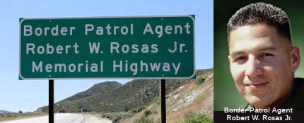 The portion of Route 8 between post mile
R51.000 and post mile R53.5000 in the County of San Diego is officially
designated the "Border Patrol Agent Robert W. Rosas Jr. Memorial
Highway". It was named in memory of United States Border Patrol
Agent Robert W. Rosas Jr., who was born and raised in El Centro,
California, and was often referred to as the "Mayor of El Centro" because
of his popularity and friendly, witty demeanor. Agent Rosas graduated from
Central Union High School in 1997 where he met his future wife, Rosalie.
Prior to becoming a United States Border Patrol Agent, Agent Rosas worked
as a correctional officer for six years at Centinela State Prison, in
addition to serving two years as a reserve police officer for the El
Centro Police Department. Agent Rosas began his career with the United
States Border Patrol on May 22, 2006, as a member of the 621st Session of
the Border Patrol Academy. Around his fellow agents at the Campo Station,
Agent Rosas was known for his enthusiasm and sound work ethic in carrying
out his sworn duties. His leadership skills were also evident through his
efforts in organizing and managing the station's softball team. On July
23, 2009, Agent Rosas was working near the United States-Mexico
international border near Campo, California, and was responding to
suspected illegal cross-border activity when fellow agents heard multiple
gun shots. After a brief search, Agent Rosas was found lying on the
ground, mortally wounded. It was later determined that Rosas’
killers lured him into the brush in the remote borderland to rob him of
his night vision goggles and other equipment. A suspect was later
identified, tried, and convicted in the murder. Agent Rosas was 30 years
old at the time of his death. Named by Senate Concurrent Resolution 37,
Resolution Chapter 54, on July 14, 2011. Unveiling of the signs
memorializing Rosas were part of a ceremony at the Campo Border Patrol
Station on April 13, 2012.
The portion of Route 8 between post mile
R51.000 and post mile R53.5000 in the County of San Diego is officially
designated the "Border Patrol Agent Robert W. Rosas Jr. Memorial
Highway". It was named in memory of United States Border Patrol
Agent Robert W. Rosas Jr., who was born and raised in El Centro,
California, and was often referred to as the "Mayor of El Centro" because
of his popularity and friendly, witty demeanor. Agent Rosas graduated from
Central Union High School in 1997 where he met his future wife, Rosalie.
Prior to becoming a United States Border Patrol Agent, Agent Rosas worked
as a correctional officer for six years at Centinela State Prison, in
addition to serving two years as a reserve police officer for the El
Centro Police Department. Agent Rosas began his career with the United
States Border Patrol on May 22, 2006, as a member of the 621st Session of
the Border Patrol Academy. Around his fellow agents at the Campo Station,
Agent Rosas was known for his enthusiasm and sound work ethic in carrying
out his sworn duties. His leadership skills were also evident through his
efforts in organizing and managing the station's softball team. On July
23, 2009, Agent Rosas was working near the United States-Mexico
international border near Campo, California, and was responding to
suspected illegal cross-border activity when fellow agents heard multiple
gun shots. After a brief search, Agent Rosas was found lying on the
ground, mortally wounded. It was later determined that Rosas’
killers lured him into the brush in the remote borderland to rob him of
his night vision goggles and other equipment. A suspect was later
identified, tried, and convicted in the murder. Agent Rosas was 30 years
old at the time of his death. Named by Senate Concurrent Resolution 37,
Resolution Chapter 54, on July 14, 2011. Unveiling of the signs
memorializing Rosas were part of a ceremony at the Campo Border Patrol
Station on April 13, 2012.
(Image Sources: OC Register, 4/17/2012; US CBP)
 The westbound segment of Route 8, between
westbound postmile R4.60 and R6.60, in the County of Imperial, as the "Deputy
Probation Officer Irene B. Rios Memorial Highway". It was named in
memory of Deputy Probation Officer Irene Beatrice Rios of the Imperial
County Probation Department (ICPD), who died in the line of duty on August
13, 2008, who was the first female peace officer to die in the line of
duty in Imperial County. Deputy Probation Officer Irene Rios was born in
Brawley on July 20, 1980, to Emilio and Elisabet Rios. She grew up in
Holtville, where she also attended local schools. After graduating from
Holtville High School in 1998, she pursued her education at Imperial
Valley College in Imperial, and two years later, transferred to San Diego
State University, Imperial Valley Campus, where she received a bachelor of
science degree in criminal justice administration with a minor in
psychology/ Shortly thereafter, Deputy Probation Officer Irene Rios began
working for the Betty Jo McNeece Receiving Home in 2002, where she worked
until she was hired as Deputy Probation Officer for the Juvenile Division
in January 2005. She graduated from Probation Officer Core Academy during
her first year of employment. Her love for helping families and youth
began when she started working at the receiving home where she found a
balance of her two wishes of working in law enforcement and of working
with children. In keeping Deputy Probation Officer Irene Rios' spirit
alive, her brothers and sisters in law enforcement formed the 718
Foundation in order to grant scholarships to students from local,
low-income families to promote professional, academic, or artistic
achievement through the Irene B. Rios Memorial Scholarship. Named by
Assembly Concurrent Resolution 66, Resolution Chapter 99, on September 22,
2011.
The westbound segment of Route 8, between
westbound postmile R4.60 and R6.60, in the County of Imperial, as the "Deputy
Probation Officer Irene B. Rios Memorial Highway". It was named in
memory of Deputy Probation Officer Irene Beatrice Rios of the Imperial
County Probation Department (ICPD), who died in the line of duty on August
13, 2008, who was the first female peace officer to die in the line of
duty in Imperial County. Deputy Probation Officer Irene Rios was born in
Brawley on July 20, 1980, to Emilio and Elisabet Rios. She grew up in
Holtville, where she also attended local schools. After graduating from
Holtville High School in 1998, she pursued her education at Imperial
Valley College in Imperial, and two years later, transferred to San Diego
State University, Imperial Valley Campus, where she received a bachelor of
science degree in criminal justice administration with a minor in
psychology/ Shortly thereafter, Deputy Probation Officer Irene Rios began
working for the Betty Jo McNeece Receiving Home in 2002, where she worked
until she was hired as Deputy Probation Officer for the Juvenile Division
in January 2005. She graduated from Probation Officer Core Academy during
her first year of employment. Her love for helping families and youth
began when she started working at the receiving home where she found a
balance of her two wishes of working in law enforcement and of working
with children. In keeping Deputy Probation Officer Irene Rios' spirit
alive, her brothers and sisters in law enforcement formed the 718
Foundation in order to grant scholarships to students from local,
low-income families to promote professional, academic, or artistic
achievement through the Irene B. Rios Memorial Scholarship. Named by
Assembly Concurrent Resolution 66, Resolution Chapter 99, on September 22,
2011.
(Image Source: Officer Down Memorial Page)
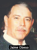 The portion of I-8 in the City
of El Centro (~ 008 IMP R36.432/R39.527) is named the "Caltrans Highway
Maintenance Leadworker Jaime Obeso Memorial Highway". It was named
in memory of Jaime Garcia Obeso, of the City of Imperial, who passed away
on June 7, 2011, when he was struck by an errant motorist while working on
a stretch of Route 8 near the Sunbeam Rest Area for the Department of
Transportation (Caltrans). Jaime Obeso was born to Gregorio and Magdalena
Obeso on January 25, 1958, in El Centro, California. He attended Ben Hulse
Elementary, Frank Wright Junior High, and Imperial High School. While at
Imperial High School, he excelled in football and track, holding records
in pole vault, and 4x100 relay. Jaime Obeso worked for H.E. Wiggins and
Sons for many years and later gained employment with Caltrans. He was
known as a hard working employee and he received many awards during his
service with Caltrans. His last promotion was as a Leadworker with the El
Centro Travelway Crew. Named by Senate Concurrent Resolution 52,
Resolution Chapter 94, on September 15, 2011.
The portion of I-8 in the City
of El Centro (~ 008 IMP R36.432/R39.527) is named the "Caltrans Highway
Maintenance Leadworker Jaime Obeso Memorial Highway". It was named
in memory of Jaime Garcia Obeso, of the City of Imperial, who passed away
on June 7, 2011, when he was struck by an errant motorist while working on
a stretch of Route 8 near the Sunbeam Rest Area for the Department of
Transportation (Caltrans). Jaime Obeso was born to Gregorio and Magdalena
Obeso on January 25, 1958, in El Centro, California. He attended Ben Hulse
Elementary, Frank Wright Junior High, and Imperial High School. While at
Imperial High School, he excelled in football and track, holding records
in pole vault, and 4x100 relay. Jaime Obeso worked for H.E. Wiggins and
Sons for many years and later gained employment with Caltrans. He was
known as a hard working employee and he received many awards during his
service with Caltrans. His last promotion was as a Leadworker with the El
Centro Travelway Crew. Named by Senate Concurrent Resolution 52,
Resolution Chapter 94, on September 15, 2011.
(Image Source: Legacy.Com Obituary)
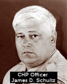 The portion of this route between Gordon's Well Road (~ 008 IMP R73.495) and
Brock Research Center Road (~ 008 IMP R68.825) in Imperial County is named
the "James D. Schultz Freeway". This segment was named in memory of
California Highway Patrol (CHP) Officer James D. Schultz, a dedicated
officer, who was killed in the line of duty at the age of 46 years while
conducting an abandoned vehicle check on westbound I-8 between Gordon's
Well Road and Brock Research Center Road in Imperial County. Officer
Schultz, while conducting his investigation, was struck by an errant,
sleepy driver during the late evening of November 15, 1996, and died in
the early morning hours on November 16 as a result of injuries sustained
in the collision. After graduating from Fredonia High School on June 23,
1968, in Fredonia, New York, Officer Schultz enlisted in the United States
Army on August 19, 1968. He bravely served his country, including a
one-year assignment in Vietnam, and received an honorable discharge from
the United States Army on August 18, 1971. He began his career with CHP on
January 31, 1972, and proudly served the State of California in the South
Los Angeles, Oakland, El Centro, Garberville, Barstow, Bridgeport, and
Winterhaven CHP areas. Officer Schultz was known by his fellow officers
for his dedication to CHP and to the protection of the people of
California. Named by Senate Concurrent Resolution (SCR) 21, Resolution
Chapter 87, on 7/10/2007.
The portion of this route between Gordon's Well Road (~ 008 IMP R73.495) and
Brock Research Center Road (~ 008 IMP R68.825) in Imperial County is named
the "James D. Schultz Freeway". This segment was named in memory of
California Highway Patrol (CHP) Officer James D. Schultz, a dedicated
officer, who was killed in the line of duty at the age of 46 years while
conducting an abandoned vehicle check on westbound I-8 between Gordon's
Well Road and Brock Research Center Road in Imperial County. Officer
Schultz, while conducting his investigation, was struck by an errant,
sleepy driver during the late evening of November 15, 1996, and died in
the early morning hours on November 16 as a result of injuries sustained
in the collision. After graduating from Fredonia High School on June 23,
1968, in Fredonia, New York, Officer Schultz enlisted in the United States
Army on August 19, 1968. He bravely served his country, including a
one-year assignment in Vietnam, and received an honorable discharge from
the United States Army on August 18, 1971. He began his career with CHP on
January 31, 1972, and proudly served the State of California in the South
Los Angeles, Oakland, El Centro, Garberville, Barstow, Bridgeport, and
Winterhaven CHP areas. Officer Schultz was known by his fellow officers
for his dedication to CHP and to the protection of the people of
California. Named by Senate Concurrent Resolution (SCR) 21, Resolution
Chapter 87, on 7/10/2007.
(Image Source: California Assn of Highway Patrolmen)
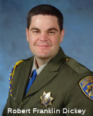 The segment of I-8, between Sidewinder Road (~
008 IMP R88.702) and Ogilby Road (~ 008 IMP R83.834), in the Town of
Winterhaven in the County of Imperial, is designated the "Officer
Robert Franklin Dickey Memorial Highway". This segment was named in
memory of CHP Officer Robert Franklin Dickey who was killed in the line of
duty on June 10, 2007. Officer Dickey graduated from the CHP Academy on
February 22, 2002, and was assigned to the central Los Angeles area. On
May 1, 2003, Officer Dickey transferred to the Winterhaven area. Named by
Assembly Concurrent Resolution (ACR) 80, Resolution Chapter 70, on
7/3/2008.
The segment of I-8, between Sidewinder Road (~
008 IMP R88.702) and Ogilby Road (~ 008 IMP R83.834), in the Town of
Winterhaven in the County of Imperial, is designated the "Officer
Robert Franklin Dickey Memorial Highway". This segment was named in
memory of CHP Officer Robert Franklin Dickey who was killed in the line of
duty on June 10, 2007. Officer Dickey graduated from the CHP Academy on
February 22, 2002, and was assigned to the central Los Angeles area. On
May 1, 2003, Officer Dickey transferred to the Winterhaven area. Named by
Assembly Concurrent Resolution (ACR) 80, Resolution Chapter 70, on
7/3/2008.
(Image Source: California Assn of Highway Patrolmen)
The entire route (from San Diego to the Arizona state line) has also been designated the "Border Friendship Route". It was named by Senate Concurrent Resolution 104, Chapter 254, in 1968.
 Named Structures
 Bridge 57-720, the I-8/I-805 interchange in San Diego
county (~ 008 SD 4.014/SD 4.773), is named the "Jack Schrade
Interchange/Mission Valley Viaduct". It was built in 1973, and named
by Senate Concurrent Resolution 41, Chapter 101, in 1972. California State
Senator Jack Schrade (R-Del Mar, 1963-1976) was a delegate to Republican
National Convention from California in 1964. During the UC Berkeley
student uprisings in the 1960s, Sen. Schrade called for dismissal of
professors and expulsion of students who have taken part in Free Speech
Movement activities, going so far as to draft a proposed constitutional
amendment to require similar disciplinary action in the event of future
demonstrations. Sen. Schrade also provided support for environmental
causes. As chairman of the Senate Rules Committee in 1970, he introduced
Senate Resolution No. 137, that officially established May 15 at Peace
Officers' Memorial Day.
Bridge 57-720, the I-8/I-805 interchange in San Diego
county (~ 008 SD 4.014/SD 4.773), is named the "Jack Schrade
Interchange/Mission Valley Viaduct". It was built in 1973, and named
by Senate Concurrent Resolution 41, Chapter 101, in 1972. California State
Senator Jack Schrade (R-Del Mar, 1963-1976) was a delegate to Republican
National Convention from California in 1964. During the UC Berkeley
student uprisings in the 1960s, Sen. Schrade called for dismissal of
professors and expulsion of students who have taken part in Free Speech
Movement activities, going so far as to draft a proposed constitutional
amendment to require similar disciplinary action in the event of future
demonstrations. Sen. Schrade also provided support for environmental
causes. As chairman of the Senate Rules Committee in 1970, he introduced
Senate Resolution No. 137, that officially established May 15 at Peace
Officers' Memorial Day.
(Image Source: Our Campaigns)
 The overpass on I-8 at 2nd Street in El Cajon (~ 008 SD 17.36) is
named the "Danielle van Dam Memorial Overpass." Named after
Danielle Nicole van Dam, a young child abducted from her bedroom, and for
whom the search, story, and subsequent trial garnered national attention.
Danielle was born on September 22, 1994, in Plano, Texas. Her favorite
colors were pink and purple and she enjoyed writing in her journals,
ballet, gymnastics, Girl Scouts, and playing with her brothers and with
friends. When she was seven, Danielle's family was planning a trip to
Italy which was to take place on February 9, 2002, but before this could
happen, on February 2, 2002, Danielle was abducted from her bedroom by a
neighbor. A search center was put together by the Laura Recovery Center
and over 2,000 people volunteered to search for Danielle. On February 27,
2002, Danielle's body was found on Dehesa Road in El Cajon, near I-8. Wikipedia has more details on the sad story. Named by Assembly Concurrent
Resolution 73, Chaptered 7/2/2003, Chapter 86.
The overpass on I-8 at 2nd Street in El Cajon (~ 008 SD 17.36) is
named the "Danielle van Dam Memorial Overpass." Named after
Danielle Nicole van Dam, a young child abducted from her bedroom, and for
whom the search, story, and subsequent trial garnered national attention.
Danielle was born on September 22, 1994, in Plano, Texas. Her favorite
colors were pink and purple and she enjoyed writing in her journals,
ballet, gymnastics, Girl Scouts, and playing with her brothers and with
friends. When she was seven, Danielle's family was planning a trip to
Italy which was to take place on February 9, 2002, but before this could
happen, on February 2, 2002, Danielle was abducted from her bedroom by a
neighbor. A search center was put together by the Laura Recovery Center
and over 2,000 people volunteered to search for Danielle. On February 27,
2002, Danielle's body was found on Dehesa Road in El Cajon, near I-8. Wikipedia has more details on the sad story. Named by Assembly Concurrent
Resolution 73, Chaptered 7/2/2003, Chapter 86.
(Image Source: San Diego Jewish World, 4/7/2016; Wikipedia)
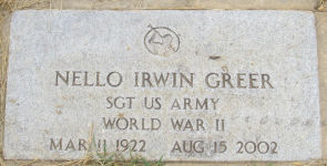 The Pine Valley Creek Bridge (008 SD R041.70) is named the "Nello Irwin
Greer Memorial Bridge". This segment was named in memory of Nello
Irwin Greer. Greer was born on March 9, 1922, in Phoenix, Arizona and,
after briefly residing in Victorville, California, moved to St. Johns,
Arizona where he spent his formative years. Mr. Greer fought during World
War II, serving with General George S. Patton, Jr. at the Battle of the
Bulge. After returning from the war, Mr. Greer began his career with the
Department of Transportation (Caltrans) in 1948, advancing to an
engineering position and working on many state freeway projects in San
Bernardino, California. In 1960, Mr. Greer moved to District 11 in San
Diego, California, where he lived until retiring from Caltrans in 1977,
and some of his projects there include Route 163 from I-8 north to the
Geneese exit, the design of the first bridge on Friars Road with 13 lanes
of traffic, as well as various other projects throughout the county. The
Pine Valley Project was by far the most incredible of Mr. Greer's
projects; while Caltrans wanted the project's freeway to run through the
town of Pine Valley, California, Mr. Greer moved the project to the
location where it currently exists, overcoming numerous obstacles to
complete it. One such obstacle was the design of a new bridge that was
over 800 feet high, and Mr. Greer suggested its construction as a hollow
bridge. The construction of the bridge in the Pine Valley Project received
many engineering awards, and the projected removals and quantities to
finish the Pine Valley Project along with the tightest budget in Caltrans
history, earned Mr. Greer many awards and recognition throughout the
country. After retiring, Mr. Greer worked for an engineering company that
sent him all over the world designing and supervising the projects that he
had designed, including the Glenwood Canyon Project (Interstate 70) in
Glenwood, Colorado, that, was named the eighth man-made wonder of the
world. Mr. Greer died on August 15, 2002. Named by Senate Concurrent
Resolution (SCR) 33, Resolution Chapter 89, on 7/10/2007. At the time of
its construction, it was the first bridge constructed in the United States
using the segmental balanced cantilever method. The northern span is 1,691
ft long while the southern span is 1,741 ft long. The two spans rise 450
ft above the valley floor, placing Pine Valley Creek Bridge among the
highest bridges in the United States.
The Pine Valley Creek Bridge (008 SD R041.70) is named the "Nello Irwin
Greer Memorial Bridge". This segment was named in memory of Nello
Irwin Greer. Greer was born on March 9, 1922, in Phoenix, Arizona and,
after briefly residing in Victorville, California, moved to St. Johns,
Arizona where he spent his formative years. Mr. Greer fought during World
War II, serving with General George S. Patton, Jr. at the Battle of the
Bulge. After returning from the war, Mr. Greer began his career with the
Department of Transportation (Caltrans) in 1948, advancing to an
engineering position and working on many state freeway projects in San
Bernardino, California. In 1960, Mr. Greer moved to District 11 in San
Diego, California, where he lived until retiring from Caltrans in 1977,
and some of his projects there include Route 163 from I-8 north to the
Geneese exit, the design of the first bridge on Friars Road with 13 lanes
of traffic, as well as various other projects throughout the county. The
Pine Valley Project was by far the most incredible of Mr. Greer's
projects; while Caltrans wanted the project's freeway to run through the
town of Pine Valley, California, Mr. Greer moved the project to the
location where it currently exists, overcoming numerous obstacles to
complete it. One such obstacle was the design of a new bridge that was
over 800 feet high, and Mr. Greer suggested its construction as a hollow
bridge. The construction of the bridge in the Pine Valley Project received
many engineering awards, and the projected removals and quantities to
finish the Pine Valley Project along with the tightest budget in Caltrans
history, earned Mr. Greer many awards and recognition throughout the
country. After retiring, Mr. Greer worked for an engineering company that
sent him all over the world designing and supervising the projects that he
had designed, including the Glenwood Canyon Project (Interstate 70) in
Glenwood, Colorado, that, was named the eighth man-made wonder of the
world. Mr. Greer died on August 15, 2002. Named by Senate Concurrent
Resolution (SCR) 33, Resolution Chapter 89, on 7/10/2007. At the time of
its construction, it was the first bridge constructed in the United States
using the segmental balanced cantilever method. The northern span is 1,691
ft long while the southern span is 1,741 ft long. The two spans rise 450
ft above the valley floor, placing Pine Valley Creek Bridge among the
highest bridges in the United States.
(Image Source: Find a Grave)
 The overpass on I-8 at Buckman Springs Road
(008 SD R048.84R) in Pine Valley is named the "Army Sergeant Brud
Joseph Cronkrite Memorial Bridge." This segment was named in memory
of SGT Brud Joseph Cronkrite. Cronkrite was born on June 24, 1981, in El
Cajon at El Cajon Valley Hospital. He moved to Potrero, California, with
his parents in December of 1994, at the age of 13, and fell in love with
the family' s 11-acre property, which he dreamed of someday inheriting and
living at with his future family. Brud attended Mount Empire High School
and was on the wrestling team. Brud joined the United States Army in March
of 2001, attended boot camp and special training at Fort Knox, graduating
with honors and receiving an excellent in marksmanship, and knew that he
had found his calling in life. He was stationed at Camp Casey in South
Korea for one year, and was then assigned to the 1st Battalion, 37th
Armor, 1st Armored Division, in Friedberg, Germany, and he served in Iraq
for one year. Brud's Division was scheduled to come home when their
assignment in Iraq was extended by the President. Three weeks after this
extension, Brud died in Baghdad, Iraq, on May 14, 2004, at the age of 22
years, from injuries that he sustained on May 13, 2004, in Karbala, when a
rocket-propelled grenade fired into a building near him during a security
patrol. Brud was awarded the Bronze Star and the Purple Heart, and is
buried at the Fort Rosencrans Cemetary. Brud was the 775th American
soldier killed in the Iraq War and he and his family gave the ultimate
sacrifice to keep all Americans safe. Named by Senate Concurrent
Resolution (SCR) 32, Resolution Chapter 95, on 7/12/2007.
The overpass on I-8 at Buckman Springs Road
(008 SD R048.84R) in Pine Valley is named the "Army Sergeant Brud
Joseph Cronkrite Memorial Bridge." This segment was named in memory
of SGT Brud Joseph Cronkrite. Cronkrite was born on June 24, 1981, in El
Cajon at El Cajon Valley Hospital. He moved to Potrero, California, with
his parents in December of 1994, at the age of 13, and fell in love with
the family' s 11-acre property, which he dreamed of someday inheriting and
living at with his future family. Brud attended Mount Empire High School
and was on the wrestling team. Brud joined the United States Army in March
of 2001, attended boot camp and special training at Fort Knox, graduating
with honors and receiving an excellent in marksmanship, and knew that he
had found his calling in life. He was stationed at Camp Casey in South
Korea for one year, and was then assigned to the 1st Battalion, 37th
Armor, 1st Armored Division, in Friedberg, Germany, and he served in Iraq
for one year. Brud's Division was scheduled to come home when their
assignment in Iraq was extended by the President. Three weeks after this
extension, Brud died in Baghdad, Iraq, on May 14, 2004, at the age of 22
years, from injuries that he sustained on May 13, 2004, in Karbala, when a
rocket-propelled grenade fired into a building near him during a security
patrol. Brud was awarded the Bronze Star and the Purple Heart, and is
buried at the Fort Rosencrans Cemetary. Brud was the 775th American
soldier killed in the Iraq War and he and his family gave the ultimate
sacrifice to keep all Americans safe. Named by Senate Concurrent
Resolution (SCR) 32, Resolution Chapter 95, on 7/12/2007.
(Image Source: Casper Star Tribune, 5/28/2012)
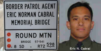 The Round Mountain Bridge located between Postmile R072.55 and Postmile R072.57 on I-8 in the County of San Diego is
named the "Border Patrol Agent Eric Norman Cabral Memorial Bridge".
It was named in memory of Border Patrol Agent Eric Norman Cabral, who was
born in 1976 in San Diego, California. Agent Cabral was active in sports
and athletics and graduated from Morse High School in 1994. His passion
for health and fitness led him to obtain a Bachelors Degree of Science in
Kinesiology from the San Diego State University in 2001 and a
Master’s Degree of Science in Physical Education from Azusa Pacific
University in 2003. Before joining the Border Patrol, Agent Cabral worked
as an Exercise Physiologist at US Spine and Sport in San Diego. He later
became the Assistant Fitness Director, as well as a professor, at
Southwestern College where he taught health and fitness classes for three
years. In September 2005, he joined the United States Border Patrol and
graduated with the 601st Academy Session in February 2006. On July 26,
2007, Agent Cabral died from heat-related injuries after tracking a group
of suspected undocumented immigrants on foot. Agent Cabral was found
unconscious along the Carrizo Gorge Railway railroad tracks, near the
south entrance to the De Anza Springs Resort, about one-half mile north of
I-8. He was flown to Sharp Grossmont Hospital in San Diego via Mercy Air,
where, tragically, Agent Cabral was pronounced dead. Agent Cabral was the
fourth Border Patrol agent to die in the line of duty during 2007. Agent
Cabral’s death is a reminder of the dangers that agents face every
day while securing America’s borders and protecting its people.
Named by Assembly Concurrent Resolution 99, Res. Chapter 39, on 05/30/14.
The Round Mountain Bridge located between Postmile R072.55 and Postmile R072.57 on I-8 in the County of San Diego is
named the "Border Patrol Agent Eric Norman Cabral Memorial Bridge".
It was named in memory of Border Patrol Agent Eric Norman Cabral, who was
born in 1976 in San Diego, California. Agent Cabral was active in sports
and athletics and graduated from Morse High School in 1994. His passion
for health and fitness led him to obtain a Bachelors Degree of Science in
Kinesiology from the San Diego State University in 2001 and a
Master’s Degree of Science in Physical Education from Azusa Pacific
University in 2003. Before joining the Border Patrol, Agent Cabral worked
as an Exercise Physiologist at US Spine and Sport in San Diego. He later
became the Assistant Fitness Director, as well as a professor, at
Southwestern College where he taught health and fitness classes for three
years. In September 2005, he joined the United States Border Patrol and
graduated with the 601st Academy Session in February 2006. On July 26,
2007, Agent Cabral died from heat-related injuries after tracking a group
of suspected undocumented immigrants on foot. Agent Cabral was found
unconscious along the Carrizo Gorge Railway railroad tracks, near the
south entrance to the De Anza Springs Resort, about one-half mile north of
I-8. He was flown to Sharp Grossmont Hospital in San Diego via Mercy Air,
where, tragically, Agent Cabral was pronounced dead. Agent Cabral was the
fourth Border Patrol agent to die in the line of duty during 2007. Agent
Cabral’s death is a reminder of the dangers that agents face every
day while securing America’s borders and protecting its people.
Named by Assembly Concurrent Resolution 99, Res. Chapter 39, on 05/30/14.
(Image Sources: US CBP Article on Dedication; US CBP EOW)
This route also has the following Safety Roadside Rest Areas:
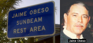 Sunbeam, in Imperial County, 6 mi W of El Centro
(~ 008 IMP R31.242). This rest area is officially named the
"Jaime Obeso Sunbeam Rest Area". It was named in memory of Jaime Garcia Obeso,
of the City of Imperial, who passed away on June 7, 2011, when he was
struck by an errant motorist while working on a stretch of Route 8 near
the Sunbeam Rest Area for the Department of Transportation (Caltrans).
Jaime Obeso was born to Gregorio and Magdalena Obeso on January 25,
1958, in El Centro, California. He attended Ben Hulse Elementary, Frank
Wright Junior High, and Imperial High School. While at Imperial High
School, he excelled in football and track, holding records in pole
vault, and 4x100 relay. Jaime Obeso worked for H.E. Wiggins and Sons for
many years and later gained employment with Caltrans. He was known as a
hard working employee and he received many awards during his service
with Caltrans. His last promotion was as a Leadworker with the El Centro
Travelway Crew. Named by Senate Concurrent Resolution 52, Resolution
Chapter 94, on September 15, 2011.
Sunbeam, in Imperial County, 6 mi W of El Centro
(~ 008 IMP R31.242). This rest area is officially named the
"Jaime Obeso Sunbeam Rest Area". It was named in memory of Jaime Garcia Obeso,
of the City of Imperial, who passed away on June 7, 2011, when he was
struck by an errant motorist while working on a stretch of Route 8 near
the Sunbeam Rest Area for the Department of Transportation (Caltrans).
Jaime Obeso was born to Gregorio and Magdalena Obeso on January 25,
1958, in El Centro, California. He attended Ben Hulse Elementary, Frank
Wright Junior High, and Imperial High School. While at Imperial High
School, he excelled in football and track, holding records in pole
vault, and 4x100 relay. Jaime Obeso worked for H.E. Wiggins and Sons for
many years and later gained employment with Caltrans. He was known as a
hard working employee and he received many awards during his service
with Caltrans. His last promotion was as a Leadworker with the El Centro
Travelway Crew. Named by Senate Concurrent Resolution 52, Resolution
Chapter 94, on September 15, 2011. Historical Route
 ACR 123 (Resolution Chapter 104, 8/16/2006) designated segments of former U.S. Highway Route 80 in San Diego and Imperial Counties as Historic
U.S. Highway Route 80, and requested the Department of
Transportation to design and facilitate the posting of appropriate signs
and take related actions in that regard. The resolution noted that US 80,
largely parallel to current I-8, was a 180-mile highway spanning San Diego
and Imperial Counties from San Diego Bay to the Colorado River, and played
a major role in the development of this state during much of the 20th
century. In 1909, California voters approved a statewide bond measure for
road improvement purposes in the amount of $18 million, providing, among
other things, funds to construct a road between San Diego and Imperial
Counties, and their county seats of San Diego and El Centro. In 1915, a
unique wood plank road was built over the Imperial Valley sand hills,
resulting in a shorter route. In 1925, the federal government became
involved in standardized highway route designations across the nation and
even numbers were assigned to major highways running east and west, and
odd numbers for highway running north and south. The numbering of highways
proceeded in numerical order beginning in the north and east and
continuing south and west, respectively, and, as a result, the routing
along California's southern border was formally designated as US 80. This
road, from San Diego to Tybee Island, Georgia, was adopted as US 80 on
November 11, 1926. US 80 was the first ocean-to-ocean transcontinental
highway to be completed, and portions of the route were known as the
Bankhead, Broadway of America, Dixie, Lee, Old Spanish Trail, and Southern
Transcontinental Highway.
This portion approved as chargeable Interstate on 7/7/1947. There was an adjustment E of San Diego in August 1965. In August 1957 this was proposed as I-8. In December 1957, the California Department of Highways proposed designating this as I-10, following a recommendation from Arizona. This was rejected by AASHTO, and this went back to the I-8 designation.
Scenic Route Classified Landcaped Freeway
The following segments are designated as Classified Landscaped Freeway:
| County | Route | Starting PM | Ending PM |
| San Diego | 8 | L0.71 | R0.00 |
| San Diego | 8 | R0.00 | R0.11 |
| San Diego | 8 | R0.18 | 5.18 |
| San Diego | 8 | 5.37 | 6.52 |
| San Diego | 8 | 6.79 | 8.12 |
| San Diego | 8 | 8.20 | 12.86 |
| San Diego | 8 | 12.94 | 13.26 |
| San Diego | 8 | 14.38 | R18.21 |
| San Diego | 8 | R18.43 | R18.92 |
| Imperial | 8 | R36.46 | R38.48 |
 Exit Information
 Other WWW Links Pre 1964 Signage History
 In 1934, Route 8 was signed along the route
from Stockton to the California-Nevada State Line near Woodfords, via
Jackson. In 1964, the portion running (1) from Stockton to Route 12 near
Valley Springs via Linden and Bellota, and then (2) from Route 12 near
Fosteria through Mokelumne Hill was resigned as Route 26. This routing was
LRN 5.
In 1934, Route 8 was signed along the route
from Stockton to the California-Nevada State Line near Woodfords, via
Jackson. In 1964, the portion running (1) from Stockton to Route 12 near
Valley Springs via Linden and Bellota, and then (2) from Route 12 near
Fosteria through Mokelumne Hill was resigned as Route 26. This routing was
LRN 5.
The remainder of 1934 Route 8, running from Route 49 near Jackson to Woodfords (near the Nevada state line) through Pine Gr., Cooks Sta., and through Carson Pass, was resigned as Route 88 by at least 1948. The portion between Woodfords and the Nevada State Line was cosigned with Route 4 until 1963. It was LRN 34.
LRN 34 was defined in 1909 as "From LRN 4 near Arno to Jackson". LRN 34
was extended over Carson Pass to Hope Valley by way of legislative action
taken during 1911. Prior to 1933 the State of California was prohibited
from maintaining highways within incorporated cities. The through
route in Jackson for eastbound LRN 34 appears to have always entered
Jackson via Sutter Street which passed by the active mines in the
city. The through route through Jackson for LRN 34 eastbound towards
Carson Pass would have been via Main Street, Water Street and Broadway.
Then, in 1921, LRN 65 was defined, providing a north/south state highway
through Jackson. LRN 65 was defined as "...that portion of the
public highway commencing at Auburn in Placer County through Placerville,
Jackson, San Andreas, and Angels to and connecting with the state highway
at Sonora, Tuolumne county..." LRN 65 passed through the city of Jackson
northbound via Broadway, Water Street, Main Street and Sutter Street
towards Martell. In 1933, the state codes were changed permitting state
highways within cities; and in 1934, the sign route system was created.
The entirety of LRN 65 was assigned as a portion of Sign Route 49.
Sign Route 8 was assigned as a new highway that followed LRN 5 from
Stockton to Mokelumne Hill, LRN 65 to Jackson and LRN 34 over Carson
Pass. Sign Route 49 and Sign Route 8 both multiplexed north from
Mokelumne Hill into Jackson via Broadway. At Water Street, Sign
Route 8 split east via LRN 34 towards Carson Pass whereas Sign Route 49
followed LRN 65 through downtown Jackson via Main Street and Sutter Street
towards Martell. By 1940, Sign Route 8 had been truncated to Mokelumne
Hill in favor Sign Route 88 east of Jackson. Sign Route 88 eastbound
had entered Jackson multiplexed with Sign Route 49 southbound on Sutter
Street, Main Street and Water Street towards Broadway. Sign Route 88
originated from Stockton and reached Jackson via LRN 97 (added to the
State Highway System during 1935) and LRN 34.
(Source: Gribblenation Blog (Tom Fearer), "The history of California State Route 49, 8 and 88 in Jackson", 4/10/2023)
In 1944, a realignment of Sign Route 49, Sign Route 88, LRN 34 and LRN 65
in Jackson was approved by the California Highway Commission as a
Post-World War II project. Sign Route 49 and LRN 65/Mother Lode
Highway were realigned west of downtown Jackson onto a new bypass
alignment. Sign Route 88 followed the new western bypass of downtown
to a new junction at the Carson Pass Highway/LRN 34 south of Jackson
Creek. The new highway alignments in Jackson were dedicated on
August 7, 1948, by State Highway Commissioner Homer P. Brown and Jackson
Mayor Edward T. Wise. The alignment of Sign Route 49 and Sign Route 88 in Jackson have remained unaltered since August 1948.
(Source: Gribblenation Blog (Tom Fearer), "The history of California State Route 49, 8 and 88 in Jackson", 4/10/2023)
 Freeway
[SHC 253.1] Entire route. Added to the Freeway and Expressway system in 1959.
 National Trails
  This route is part of the De Anza National Historic Trail.
 This route (as US 80) was part of the "Atlantic-Pacific
Highway".
This route (as US 80) was part of the "Atlantic-Pacific
Highway".
 This route (as US 80) was part of the "Old Spanish Trail".


 This route (as US 80)
appears to have been part of the "Bankhead Highway", the "Dixie
Overland Highway", the "Lee Highway", and the "Lone Star
Trail".
This route (as US 80)
appears to have been part of the "Bankhead Highway", the "Dixie
Overland Highway", the "Lee Highway", and the "Lone Star
Trail".
 Statistics
Overall statistics for Route 8:
 Blue Star Memorial Highway
The portion of this route from San Diego to the Arizona state line was designated as a "Blue Star Memorial Highway" by Assembly Concurrent Resolution 62, Ch. 107 in 1961.
 Interregional Route
[SHC 164.10] Entire route.
 Pre-1964 Legislative Route
The routing that would become LRN 8 was defined in the first highway bond act of 1909, running from Ignacio to Cordelia via Napa. By 1935, it had been codified into the highway code without change:
From Ignacio to Cordelia via Napa
The entire route was a primary route.
In 1937, Chapter 841 changed "Cordelia" to "[LRN 7] near Cordelia". In 1961, the description was relaxed to read “[LRN 1] (US 101) near Novato to [LRN 7] near Cordelia via the vicinity of Napa”.
Starting from US 101 (LRN 1), LRN 8 was signed as Route 37 until the present Route 37/Route 121 junction. It then continued N signed as Route 37 (post-1964 Route 121) to Shellville, continuing easterly towards Napa cosigned as Route 12/Route 37 (post 1964 Route 121). From Napa S, it was cosigned as Route 12/Route 29 (present-day Route 221), until Route 29 diverged. LRN 8 continued signed as Route 12 to Cordelia, where it joined with US 40 (LRN 7).
© 1996-2020 Daniel P. Faigin.
Maintained by: Daniel P. Faigin
<webmaster@cahighways.org>.
 Route 7
 Route 9