
 California Highways:
Click here for a key to the symbols used. An explanation of acronyms may be found at the bottom of the page.
 Routing
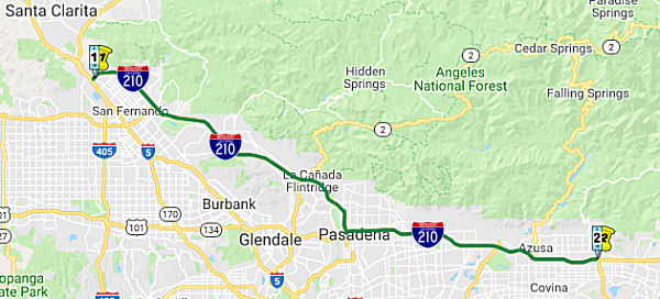 From Route 5 near Tunnel Station to Route 57 near San Dimas via the vicinity of
San Fernando
From Route 5 near Tunnel Station to Route 57 near San Dimas via the vicinity of
San Fernando
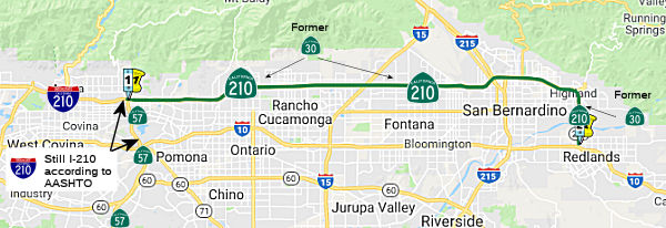 From Route 57 near San Dimas to Route 10 in Redlands via the vicinity of
Highland
From Route 57 near San Dimas to Route 10 in Redlands via the vicinity of
Highland
 Post 1964 Signage History
As defined in 1963, this route ran from "Route 5 near Tunnel Station to Route 10 near the east boundary of Los Angeles County via the vicinity of San Fernando." The Foothill Freeway was the only planned Interstate freeway route from the 1950s around Los Angeles not to have a determined routing.
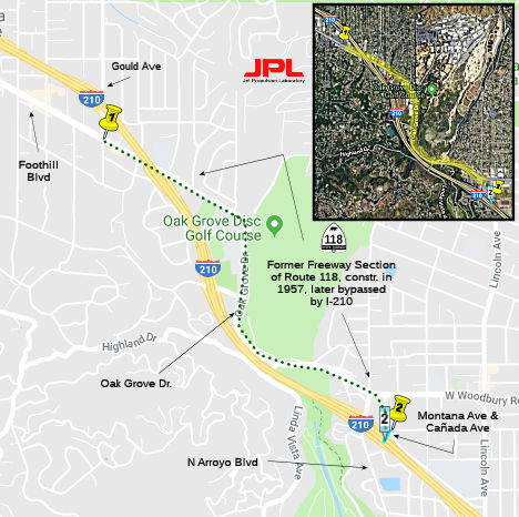 The first segment of this route opened in 1955; this is
likely the segment that ran from Foothill Blvd. near Gould Ave. east to
near the intersection of Montana Ave. and Canada Ave (cosigned with Route 118). When a new alignment over the Arroyo Seco was constructed in 1974,
the original alignment was decommissioned and reliquished to the city,
still containing the grade separations, ramps, mileage signs, and part of
the old median. now bypassed.
The first segment of this route opened in 1955; this is
likely the segment that ran from Foothill Blvd. near Gould Ave. east to
near the intersection of Montana Ave. and Canada Ave (cosigned with Route 118). When a new alignment over the Arroyo Seco was constructed in 1974,
the original alignment was decommissioned and reliquished to the city,
still containing the grade separations, ramps, mileage signs, and part of
the old median. now bypassed.
There were temporary I-210 shields along a portion of Route 118 at the
northern end of the route. Scott Parker (SParker) provided more
information regarding this:
(Source: Scott Parker (SParker) on AARoads, "Re: Temporary Interstate 210 shields on old CA state route 118", 7/24/2016)
From its I-5 terminus, the I-210 freeway did extend only to Maclay Street (then part of Route 118) until 1981, when it was extended to the Foothill Blvd./Osborne St. exit (the access road into Little Tujunga Canyon). From the east, I-210 had been completed through the Route 2 interchange to Ocean View Ave. in La Crescenta by 1976, to La Tuna Canyon by 1979, and finally to Sunland Blvd. by 1981. The section from about 2 miles east of La Tuna west to Sunland followed the ridge line of the Verdugo mountains, complete with several substantial gradients in each direction. The final section, from Sunland Blvd. to Osborne St. was completed in 1983; this crossed the Big Tujunga Wash floodplain upstream from Hansen Dam; Caltrans bridge engineers had extreme difficulties constructing the crossing because of the depth of usable bedrock, buried under layers of sand and debris washed out of the Big Tujunga canyon. This situation was virtually identical to that found in the San Bernardino area crossings of the Santa Ana River; the eventual solution also used buried caissons, tamped down until they wouldn't go any further, with bridge columns rising up from there. From 1981 to 1983 through westbound traffic exited at Sunland Blvd., went east to Wheatland, a local arterial, then north a couple of blocks to Foothill Blvd. (old Route 118), then northwest across the existing Big Tujunga bridges before turning west to the already-completed Osborne interchange, where it resumed freeway travel. It was signed "TO I-210" in both directions. This area was the location site for several film and TV productions, most notably the film "Chinatown" — the old Route 118 bridge over the Big Tujunga Wash was where the P.I. Jake, the character played by Jack Nicholson, was searching for traces of water releases from upstream. Later (1977-81) the uncompleted I-210 between MacLay and Osborne, including the Route 118 interchange, was the go-to freeway filming site for the TV series "CHiPs".
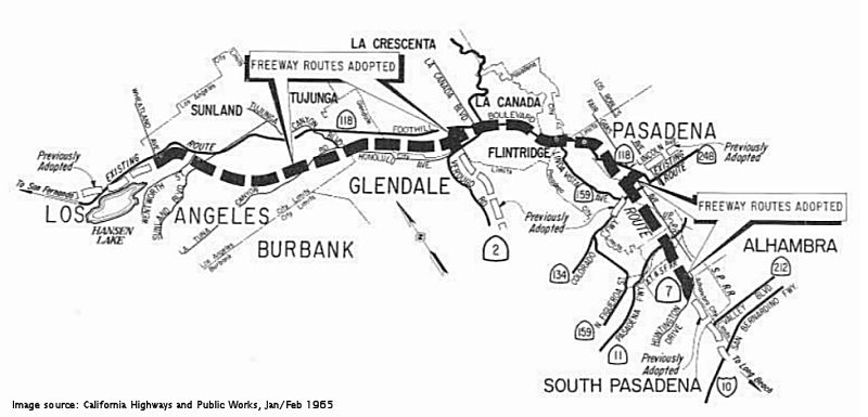
 The original plan in Pasadena was for the Foothill Freeway to connect to the Colorado Freeway,
which was the long portion of the route from Figueroa and paralleling the
original Colorado Blvd bridge. As of 1958, there were a number of route
alternatives being considered. The dashed lines in the upper portion of
the image show routes considered in July 1958; the solid lines in that
image show routes added to consideration in later 1958. The final routing
from the Colorado Freeway through Pasadena was adopted in May 1959. Note
that this original route adoption does not show the portion of the
Foothill Freeway that run NW from Pasadena through Glendale, La
Cañada, and Tujunga; at the time, that route had not been adopted.
Note also there is no indication of future Sign Route 15, future Route 7,
later Route 710.
The original plan in Pasadena was for the Foothill Freeway to connect to the Colorado Freeway,
which was the long portion of the route from Figueroa and paralleling the
original Colorado Blvd bridge. As of 1958, there were a number of route
alternatives being considered. The dashed lines in the upper portion of
the image show routes considered in July 1958; the solid lines in that
image show routes added to consideration in later 1958. The final routing
from the Colorado Freeway through Pasadena was adopted in May 1959. Note
that this original route adoption does not show the portion of the
Foothill Freeway that run NW from Pasadena through Glendale, La
Cañada, and Tujunga; at the time, that route had not been adopted.
Note also there is no indication of future Sign Route 15, future Route 7,
later Route 710.
(Source: LA Times, 11/21/1958, 6/3/1962 via Joel Windmiller,
1/18/2023 and 1/27/2023)
 The first mention of the connection to the Long Beach
Freeway was in 1961, when CHPW notes that the extension was defined by SB
480, and Advance Planning was starting to determine potential routes. In
1964, it was reported that planning was underway for the Long Beach
Freeway (Route 7, now Route 710) from the Foothill Freeway, Route 134 and
Long Beach Freeway Interchange to Norwich Avenue. On June 3-4 1964, a
routing was adopted for I-210, Route 134, and Route 710 (then Route 7).
This routing extends the Long Beach Freeway four mi N-ly to Route 134, and
then extends I-210 N-ly to Sunland. It also extends Route 2 to I-210.
Starting at Huntington Drive, the route proceeds N-ly to connect with
Route 134/I-210, swings W-ly just S of Devils Gate Dam and proceeding
generally S of Foothill Blvd through the Verdugo Mtns and across Big
Tujunga Wash to Wheatland Ave. Also noticable on the map is the inclusion
of Route 159 (old Figueroa Blvd, and the connection on Linda Vista between
Route 134 and I-210), Route 248 (which was the surface street routing of
Colorado between Route 134 and I-210 near Monrovia), and Route 212 (which
is the old Valley Blvd routing of US 60, former LRN 77). The legislative
definitions were later amended to note that Route 159 and Route 248 ceased
to be state highways after I-210 was completed. Note how this also still
shows Route 118 in the area; that was later renumbered to Route 210.
The first mention of the connection to the Long Beach
Freeway was in 1961, when CHPW notes that the extension was defined by SB
480, and Advance Planning was starting to determine potential routes. In
1964, it was reported that planning was underway for the Long Beach
Freeway (Route 7, now Route 710) from the Foothill Freeway, Route 134 and
Long Beach Freeway Interchange to Norwich Avenue. On June 3-4 1964, a
routing was adopted for I-210, Route 134, and Route 710 (then Route 7).
This routing extends the Long Beach Freeway four mi N-ly to Route 134, and
then extends I-210 N-ly to Sunland. It also extends Route 2 to I-210.
Starting at Huntington Drive, the route proceeds N-ly to connect with
Route 134/I-210, swings W-ly just S of Devils Gate Dam and proceeding
generally S of Foothill Blvd through the Verdugo Mtns and across Big
Tujunga Wash to Wheatland Ave. Also noticable on the map is the inclusion
of Route 159 (old Figueroa Blvd, and the connection on Linda Vista between
Route 134 and I-210), Route 248 (which was the surface street routing of
Colorado between Route 134 and I-210 near Monrovia), and Route 212 (which
is the old Valley Blvd routing of US 60, former LRN 77). The legislative
definitions were later amended to note that Route 159 and Route 248 ceased
to be state highways after I-210 was completed. Note how this also still
shows Route 118 in the area; that was later renumbered to Route 210.
In 1968, the first official few miles of Route 210 opened for business between Arcadia and Duarte. Work on the freeway west beyond Pasadena to I-5 Freeway and east into the Inland Valley moved steadily. In 1971, the route was completed to Foothill Boulevard in La Verne, where it dumped into the western stub of Route 30 (later renumbered as Route 210), its eastward movement (and years of late-afternoon traffic) ground to a dead stop, 28 miles short of San Bernardino. Route 210, at the present day Route 57 junction, continued continued south to I-10 near Pomona.
Note: For the history of the former I-210 portion since renumbered as Route 57, see the Route 57 page.
In 1989, San Bernardino County approved Measure I, adding ½¢ to the sales tax for highway projects. Shortly after, Los Angeles County followed suit, providing funds for the work in La Verne and Claremont. At this point, Route 30 (now Route 210) continued construction EB.
Turning now to the Route 30 portion in San Bernardino: Plans for this route began as early as 1957, but it was the mid-1970s when it got built as far east as Highland and Route 330 (which was originally part of Route 30). We then had the period of freeway doldrums that Route 210 faced. In 1990 that the work began between Highland and I-10 in Redlands. About $79 million later, that segment opened for traffic on July 1, 1993.
Note: For the history of the Route 30 portion prior to the renumbering as Route 210, see the Route 30 page.
In 1998, AB 2388, Chapter 221 split the route into two segments: "(a) Route 5 near Tunnel Station to Route 57 near San Dimas via the vicinity of San Fernando. (b) Route 57 near San Dimas to Route 10 in Redlands via the vicinity of Highland." It also renumbered the I-10 (near Pomona) to I-210 (near San Dimas) portion as Route 57, and renumbered Route 30 as Route 210. The western portion of Route 30 remained signed as Route 30 until November 2002, when is was resigned as Route 210 (state shield) (the eastern portion of "Route 30" remained as Route 30) The portion of (state) Route 210 between Route 57 and Sierra opened on November 24, 2002.
Construction of the I-15/Route 30 210 interchange began
in early/mid 1998, with the Route 210 freeway extending west to Haven
Avenue in Rancho Cucamonga, and east to Etiwanda Avenue in Fontana. When
this segment of freeway opened, it was accessible from Day Creek Blvd east
to Sierra Avenue in Fontana. Later, the segment from Route 66 to Day Creek
opened.. In late 1998, other San Bernardino County sections started
construction, to tie in with the neighboring Los Angeles County section of
Route 210 from Foothill Blvd (Route 66) to the county line through La
Verne and Claremont. Construction of the Los Angeles county section
started in 1997.
In November 2000, the California Transportation Commission had two Route 30 projects on its agenda (yes, as Route 30, not Route 210!). One was a $17.5 million request from SANBAG (San Bernardino Associated Governments) for Route 30 from Cucamonga Canyon Wash to Hermosa Avenue for a 6-lane freeway and two HOV lanes (with $7.44 million to be requested later, and $21.007 million from other sources. The $17.5 million is $2.008M state, $15.492M Federal). The second proejct was segment 4 from Hermosa Ave to Milliken Avenue. This is also 6-lanes plus 2 HOV. The cost for this is $10.166M ($1.167M state, $8.999M Federal), with $10.7M from other sources.
Construction of the remaining segment, between Sierra and the present Route 30 (from I-10 into San Bernardino), began in 2002 and was completed in 2007. Costs for the last section through Rialto and San Bernardino total approximately $233 million. The freeway includes three travel lanes and a carpool lane in each direction and features on-ramps and off-ramps at Alder Avenue, Ayala Drive and Riverside Avenue in Rialto, as well as State Street in San Bernardino. It was also designed to expand. There is a wide enough median so Caltrans could add another lane on either side at any point, up to five lanes on either side. Additionally, the freeway was built with "long life" pavement that can last up to 40 years. Once the City of Rialto extends Pepper Avenue north to the freeway, on-ramps and off-ramps will be built at Pepper (interchange planning for Pepper began in 2014). That segment is signed as (state) Route 210, although at times it was signed as "Temporary Route 30". It opened to the public on July 24, 2007.
As of December 2008, field reports confirmed that Route 30 is now completely resigned as Route 210 on all overhead signs and trailblazers, as well as on approaching routes. In some cases, a Route 210 shield was pasted over an Route 30 shield on the overhead signs, but in many cases, an entirely new sign panel was put up. About half of the postmila bridge ID signs at the overcrossings and undercrossings have been changed from SBD-30 to SBD-210. The postmile markers that showed the route as Route 30. There appears to be one exception, on the short Route 259 connector that links NB I-215 with eastbound Route 210. There is one interchange on that route at Highland Avenue. The shield on the freeway entrance sign at Highland for NB Route 259 (which defaults into EB Route 210) is still a Route 30 shield, rather than Route 210, and the sign designating it as the business route for Route 18 and Route 30 is still there approaching the Highland offramp. Additionally, there are Route 30 shields posted in Claremont and Upland along Baseline Ave and on 19th Street in Rancho Cucamonga as of December 2009.
In May 2014, it was reported that plans were announced for a new interchange on I-210 at Pepper Avenue. Construction of the ‘diamond style’ interchange will start the middle of 2015 with completion in 2016. The project is estimated to cost $19 million.
In September 2018, an explanation was given for why the portion E of
Route 57 was still not signed as an interstate route. Joy Schneider from
Caltrans District 8 (Riverside and San Bernardino counties), said state
legislation authorizing number changes for Route 210 construction project
was complex because the entire route for the highway was considered,
beginning with Los Angeles County communities all the way east through
Riverside and San Bernardino counties. Interstate status was more directly
tied Route 210 Freeway construction projects, she said, explaining that
interstate status was initiated, then partially rescinded to coincide with
construction limits. Schneider said all highway signs should all be
updated to reflect the name of I-210 once pending freeway upgrade
construction through to I-10 is completed. More work on Route 210 is
expected to begin in the fall of 2019 and updated interstate signs will
follow.
(Source: Press-Enterprise, 9/16/2018)
As for why the Route 210 portion has not been resigned as I-210, Scott
Parker provided an explanation on AARoads: On the bermed portion of the
freeway from east of the Waterman Ave. (Route 18) interchange to just east
of the Highland Ave. (former Business Route 30) there are several bridges with no
shoulders (constructed ca. 1967); the trenched section to the west has
substandard inner shoulders from the Route 259 merge to near Highland. The
1992-opened sections from Highland to I-10 in Redlands and between Route 259 and I-215 are both full interstate standard, as is the 2007 section
west to Fontana. The bridges could conceivably get waivers, but it's
likely the shoulders will have to be widened before that section is
acceptable as an Interstate.
(Source: Scott Parker (SParker) on AARoads, "Re: I–210/CA 210 on the Foothill Freeway", 2/7/2020)
In 2023. AB 776, Chapter 543, 10/8/2023, added subsection (b): "(b) Route 210 may be known and designated as the Southern California Native American Freeway or by the name described in subdivision (a) of Section 101.19." Section 101.19 states:
101.19. (a) The Department of Transportation shall work with the Native American Heritage Commission, the California Advisory Committee on Geographic Names, the Counties of Los Angeles and San Bernardino, and California tribes local to, or historically located along, Route 210, to identify appropriate locations for signs to recognize tribal lands along Route 210 and to name Route 210.
(b) The Department of Transportation shall, through the erection of highway signs and appropriate markers, provide recognition of the historical and cultural importance of the California tribes local to, or historically located in, the Counties of Los Angeles and San Bernardino. The department shall erect those signs and other appropriate markers at the appropriate locations on Route 210, as part of the department’s regularly scheduled replacement, modification, and maintenance of highway signs.
(c) The Legislature encourages the Counties of Los Angeles and San Bernardino to adopt resolutions to ensure that all people learn about the approved highway signs.
 Pre 1964 Signage History
This route was approximately LRN 157 (defined in 1933) between US 99 (present-day I-5) and Route 118. Before the freeway, this ran along Brand Blvd and Foothill Blvd. The route was LRN 9, defined in 1909, between Route 118 and the vicinity of La Verne, using a freeway routing. This was also part of LRN 240 between Pasadena and San Dimas, and was defined in 1957. Before the signage as I-210, this route included segments of Route 118 and US 66. The former Route 30 portion (i.e., E of Route 57) was LRN 190 (see the Route 30 page for more detail on this segment).
LRN 157 was defined in 1933 by Chapter 767 as the route from "[LRN 4] near Tunnel Station to [LRN 9] near San Fernando" as a state highway. It was added to the highway code in 1935 as LRN 157 with that routing. This was the route from US 99 (I-5) to Route 118, and was the eventual routing of Route 210 between I-5 and Route 118.
The route that would become LRN 9 was defined in the first set of highway bonds in 1909, with a rough routing of "San Fernando to San Bernardino". It was extended in 1933 to run to [LRN 2] (US 101) near Montalvo. By 1935, it was codified in the highway code as:
The first segment was a primary route. The first segment was always signed as Route 118. The second segment was initially Route 118 to Pasadena, and US 66 from Pasadena to San Bernardino. See the page on US 66 for the specifics of the US 66 routing. LRN 9 was later applied to the routing that would become I-210 to (then) Route 30.
The surface street routing for LRN 9 was:
(Source: Gribblenation Blog (Tom Fearer), "Interstate 210 the Foothill Freeway")
LRN 240 was defined in 1957 by Chapter 24 as “[LRN 4] near Glendale
to [LRN 26] near the east boundary of Los Angeles County on a route to be
selected by the California Highway Commission, which route may include all
or portions of any existing state highway route or routes”. The
urgency clause noted this was related to a circumferential freeway around
Los Angeles. This replaced the LRN 9 routing for the future freeway
(I-210, Route 30). This route runs from I-5 near Glendale to I-10 near the
east boundary of Los Angeles County. This LRN was used for the future
freeway routings of Route 134 between present-day I-5 and I-210, and I-210
between Route 134 and Route 57, and Route 57 between I-210 and I-10. It
duplicated the paths of LRN 161 and LRN 9. The portion between the
post-1998 Route 210/Route 57 junction and I-10 was originally also I-210.
Between San Dimas and US 60/US 70/US 99, LRN 240 was to have been
designated Route 71 (the signed Route 71 at this time ran to the east
along LRN 19).
(Source: Gibblenation Blog (Tom Fearer), "California State Route 210 (legacy of California State Route 30)", 11/2022)
LRN 190 was defined in 1933 by Chapter 767, which added the routes from "[LRN 9] near San Dimas to [LRN 26] near Redlands via Highland Avenue" and "[LRN 26] near Redlands to [LRN 43] near Big Bear Lake via Barton Flats" to the highway system. In 1935, these were added to the highway code as LRN 190, with the route:
Segment 1 corresponded to signed Route 30 to the junction with LRN 207 (which continued to LRN 43, Route 18, as signed Route 30 and was later resigned as Route 330); the portion from LRN 207 to LRN 26 (US 99, I-10) was state highway but not signed. This segment was later renumbered as State Sign Route 210. Segment 2 was Route 38. In 1957, Chapter 1911 deleted the specific routing via Highland Avenue from the first segment. See the discussion on Route 30 for more details on this segment.
LRN 190 east from LRN 9 in San Dimas utilized Base Line Road over the San
Bernardino County Line. LRN 190 continued east onto 16th Street where it
made a northbound jog onto Mountain Avenue. From Mountain Avenue LRN 190
turned east onto 19th Street. LRN 190 made a jog from 19th Street north
onto what is now Haven Avenue. From Haven Avenue LRN 190 made an eastern
turn onto Highland Avenue. LRN 190 continued east through San Bernardino
on Highway Avenue and made a southern jog at Boulder Avenue. LRN 190
continued south on Boulder Avenue and swung east onto Base Line Street.
From Base Line Street LRN 190 swung towards LRN 26 on a zig-zag alignment
of streets with a final connection being made via a spur on Orange Street.
The primary route of LRN 190 continued east from Orange Street on Lugonia
Avenue towards Big Bear.
(Source: Gribblenation Blog "Interstate 210 and California State Route 210 on the Foothill Freeway")
Note: For the history of the Route 30 portion prior to the renumbering as Route 210, see the Route 30 page.
 Status
Sylmar (I-5) to Pasadena (Route 134/Route 710 Jct)
Foothill Freeway Pavement Rehabilitation Project (~ LA R15.355 to LA R26.363)
 In April 2017, it was reported that road closures were continuing as part of the $148.5
million pavement rehabilitation project, where improvements are being made
on I-210 between Glendale and Pasadena. Construction crews will excavate
damaged pavement and place pre-made concrete slabs to provide a smoother
drive for motorists and minimize the need for further lane closures in the
future. Caltrans was closing one lane on eastbound I-210 beginning April
17, from Ocean View Boulevard to Lincoln Avenue as crews begin to replace
damaged pavement. This lane closure will remain in effect through winter
2017. There were also some off-ramp closures.
In April 2017, it was reported that road closures were continuing as part of the $148.5
million pavement rehabilitation project, where improvements are being made
on I-210 between Glendale and Pasadena. Construction crews will excavate
damaged pavement and place pre-made concrete slabs to provide a smoother
drive for motorists and minimize the need for further lane closures in the
future. Caltrans was closing one lane on eastbound I-210 beginning April
17, from Ocean View Boulevard to Lincoln Avenue as crews begin to replace
damaged pavement. This lane closure will remain in effect through winter
2017. There were also some off-ramp closures.
(Source: Caltrans District 7 Blog, 4/11/2017)
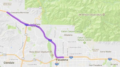
In October 2017, it was reported that since Spring
2015, Caltrans has been working on a 9.7 mile section of I-210 from the La
Crescenta-Montrose area of Glendale to Pasadena that will provide a
smoother and safer drive for motorists when the project is slated to be
finished by Summer 2018. The project is now 76% complete, with current
work focusing on replacing concrete pavement on outside lanes between the
Glendale Freeway (Route 2) and the Ventura Freeway (Route 134). In
addition to repaving and replacing lanes with precast slabs, crews are
adding new concrete median barriers and guardrails, re-striping lanes,
upgrading signs and sign structures and reconstructing curb ramps to meet
Americans with Disabilities Act (ADA) requirements. Crews will also be
repainting tunnels, and adding new electrical and lighting. One
interesting aspect of this construction is that there is a
barrier-separated fast lane NB for a portion of the work, providing no
entrances or exits, and actually running on the SB side of the freeway
(i.e., normal median barrier on the right, K-rail on the left).
(Source: Caltrans District 7 Blog, 10/18/2017)
In January 2019, it was reported that the pavement
rehabilitation project on I-210 was nearing its end. In early December
2018, crews poured the last amount of concrete on I-210 and began to apply
final striping onto the highway. Although crews have completed the work on
the pavement of the travel lanes, the contractor still has a few items to
complete before the project is finalized, including: striping,
landscaping, removing K-rail, testing the new tunnel lighting system,
installing guardrail on several ramps and connectors, installing traffic
loops, installing overhead signs on existing structures, and a number of
miscellaneous items.
(Source: Caltrans District 7 Blog, 12/31/2018)
In October 2016, the CTC authorized relinquishment of right of way in the city of La Canada Flintridge along Route 210 at Meadow Grove Street (07-LA-210-PM R21.1/R21.3), consisting of nonmotorized transportation and collateral facilities. The City, by resolution dated September 20, 2016, agreed to waive the 90-day notice requirement and accept title upon relinquishment by the State.
The SAFETEA-LU act, enacted in August 2005 as the reauthorization of TEA-21, provided the following expenditures on or near this route:
Note: For information on the "I-210 Stub" in Pasadena, see Route 710. That stub is technically the Route 710 portion of the interchange, constructed in anticipation of the eventual completion of the Long Beach Freeway to Route 210.
Pasadena to San Dimas (Route 57)
In June 2010, it was reported that a road was finally
constructed under an I-210 overpass. When I-210 was built, a tunnel was
left where the freeway passed over East Pasadena, even though there wasn't
a road. City engineers at the time didn't have the funds to build a road,
but a bridge was built. $9M was spent by the City of Pasadena to permit
City engineers to extend Walnut Street and Kinneloa Avenue so that they
intersect and so that Kinneloa continues under the freeway (~ LA R29.028).
Both roads used to stop short, which cut off traffic. Now drivers and
walkers can cross over - residents north of the freeway can easily cross
over to the businesses on the southern side of the freeway. Once the
project got the green light, the water main and electrical cables had to
be upgraded. Construction crews had to build a bridge over the flood
channel that cuts over Walnut Avenue. The street grade had to be leveled
where there was a hump in the road. However, a report from a reader of
this site clarified the situation: When I-210 was built, the Santa Fe
mainline was rerouted to the center divider between just west of Lake
Avenue to Arcadia, where a bridge crossed the eastbound lanes and the
tracks went back onto their original alignment. However, part of the
original Santa Fe mainline was far enough south of the freeway to remain.
This mainline became a spur that continued to serve businesses along the
tracks, ending just west of Allen Avenue at a lumber yard. The spur
rejoined the new mainline by passing under the eastbound lanes of I-210
near where Walnut and Kinneloa met, then moving up a tunnel to join the
new mainline at Chapman siding, near where the current Sierra Madre Villa
Gold Line station is currently located--the tunnel, in fact, is now an
access road for MTA. Originally, a set of tracks continued under the
westbound lanes to the north side of the freeway to what had been a naval
installation of some sort, which is now a self-storage establishment;
however, after construction, but before it opened in the late 1970s, the
installation closed and those tracks were removed. On the westbound lanes
of I-210, you can still see the crossing marked as Navy Spur. The old
mainline was finally abandoned in the 1980's and some of the local
businesses used the westbound overpass for equipment storage. Looking at
old topographic maps of the area, one can see the tracks and the bridges
in question--at the time of construction (mid-1970s), the city of Pasadena
had no plans to build a road under the freeway at that point as there was
an active railroad operating at that time. The overpasses were not built
for some unfunded future project--in fact, if you look at the actual
alignment of the streets and the freeway bridge before the new project, it
is clear that Kinneloa Avenue was not intended to continue northward (it
did, in fact, go all the way north to Foothill Blvd before the freeway was
built.) The street north of the freeway was named Titley Avenue,
reflecting the lack of plans for a Kinneloa extension at that time. The
westward extension of Walnut Street from Kinneloa was along the abandoned
Santa Fe right-of way.
(Source: Pasadena Star News, 5/28/10)
Truck Crashes / Gold Line
 In July 2018, it was reported that Metro plans to upgrade the Jersey Barrier
that separates its light rail lines from I-210 for about six miles, in
Pasadena and Arcadia. This is because cars and trucks have crashed through
and over the current Jersey barrier separations and onto the Gold Line
tracks. This has already resulted in major Metro service interruptions and
costly repairs; it has the potential to kill or injure transit riders.
Metro has already worked with Caltrans to install new signage on I-210
stating “trucks right 2 lanes only” and “trucks speed
limit 55.” Metro’s “I-210 Barrier Replacement
Project” is underway, but that construction is already flagged as a
“possible problem” due to constraints imposed by Caltrans. The
improved barriers are anticipated to cost $11.08 million just to design,
with designs expected to be complete by June 2019. The project includes
new stronger barriers, plus an intrusion detection system. Caltrans has
requested “detailed traffic simulations” for temporarily
shutting down a freeway traffic lane during construction, and this is
“delaying the project.” Caltrans has signed off on the type of
barrier, but wants them, wherever possible, confined to Metro’s
right-of-way. Caltrans is also apparently requesting “mitigation
measures” from Metro in order to “maintain […] the
existing freeway non-standard features.”
In July 2018, it was reported that Metro plans to upgrade the Jersey Barrier
that separates its light rail lines from I-210 for about six miles, in
Pasadena and Arcadia. This is because cars and trucks have crashed through
and over the current Jersey barrier separations and onto the Gold Line
tracks. This has already resulted in major Metro service interruptions and
costly repairs; it has the potential to kill or injure transit riders.
Metro has already worked with Caltrans to install new signage on I-210
stating “trucks right 2 lanes only” and “trucks speed
limit 55.” Metro’s “I-210 Barrier Replacement
Project” is underway, but that construction is already flagged as a
“possible problem” due to constraints imposed by Caltrans. The
improved barriers are anticipated to cost $11.08 million just to design,
with designs expected to be complete by June 2019. The project includes
new stronger barriers, plus an intrusion detection system. Caltrans has
requested “detailed traffic simulations” for temporarily
shutting down a freeway traffic lane during construction, and this is
“delaying the project.” Caltrans has signed off on the type of
barrier, but wants them, wherever possible, confined to Metro’s
right-of-way. Caltrans is also apparently requesting “mitigation
measures” from Metro in order to “maintain […] the
existing freeway non-standard features.”
(Source: Streetsblog LA, 7/19/2018)
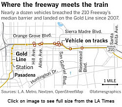
In April 2019, this subject made the news again. In
April 2018, a traffic collision in the middle of the night sent a FedEx
truck crashing across the I-210 in Pasadena and onto the tracks of the
Metro Gold Line, which is separated from the roadway by a squat concrete
barrier. The collision shut down the Gold Line through the San Gabriel
Valley for more than a day, and caused $137,959 in damage to train tracks,
power poles and overhead wires. Two more crashes followed in the in the
next half of 2018. In all, in the last decade, 10 trucks and one sedan
have crashed onto the Gold Line along the six-mile stretch where the
tracks run in the median of I-210. All but two collisions occurred in the
last five years, an increase in frequency that officials cannot explain.
Six of the 11 crashes occurred while the Gold Line was running. In late
April the Metropolitan Transportation Authority is considering doubling
the budget — to $22.6 million — to design 12 miles of new
concrete barriers aimed at beefing up the line’s protections. The
original $11-million estimate, approved in summer 2018, reflected
engineers’ assumptions that fixing the problem would be as simple as
swapping out the existing barriers for a taller, sturdier model, said
Androush Danielians, Metro’s executive engineering officer. Since
then, he said, engineers have realized that the narrow median leaves
little room for crews and equipment to maneuver, and that they will need
to shut down carpool lanes through Pasadena for as long as two years. The
replacement will happen in two phases, Danielians said, because
“there’s no way we are going to close six miles of the freeway
at the same time.” Construction will start six to nine months after
Metro finishes environmental work, which should take about a year, he
said. The precast concrete barriers along the Gold Line are just shy of
three feet high, with a familiar K-rail shape: a wide base that tapers
slightly to a straight, vertical wall. The barriers were installed in 1969
and 1976, when the roadway was built, said Caltrans spokeswoman Lauren
Wonder. Until the 1990s, they separated freeway traffic from freight
trains running through the median. Metro’s new design calls for
barriers that are 4 feet, 8 inches tall, with a smoother edge that is
designed to force truck wheels back onto the freeway. At the end of April
2019, the Metro Board approved an additional $11 million to finish design
and environmental clearance.
(Source: LA Times, 4/7/2019; StreetsblogLA
4/26/2019)
In August 2019, it was reported that an out-of-control
car from the I-210 Freeway has, again, landed on the Gold Line Metro
tracks, and the answer to the question of exactly when the planned barrier
between the two byways will be erected is finally set: Fall 2020. It was
the eleventh such incursion onto a six-mile stretch of Metro Gold Line
tracks by cars knocked from I-210. Each time, the Gold Line has been
closed, sometimes for weeks, in order to repair the damage. In April, and
in response, the Los Angeles County Metropolitan Transit Authority (Metro)
board of directors approved an additional $11 million into a barrier
replacement project with a total contract value of $41 million. It was
reported at the time that a plan to construct stronger, taller barriers
and install an intrusion detection system, turned out to be more
complicated than Metro staff originally anticipated. HOV lanes were to be
pulled from operation on the freeway and tracks on the Gold Line would be
shuttered too. Such actions signified an increase in pollution caused by
the project which, in turn, required a more expansive environmental study
than originally expected.Metro, he explained, just received approval from
the California Department of Transportation on proposed stage construction
plans for Project 1. “Metro is still working with Caltrans on
getting our Project 1 design plans approved,” said Haas. Project 1
will run from Michillinada Avenue to the Iconic Bridge for about 1.5 miles
along the I-210. Project 2 will span from the Marengo Tunnel to
Michillinda Avenue. Construction on Project 1 is expected to last 18
months from its fall 2020 starting date, said Haas. Project 2, he
explained, “is about a year behind Project 1.”
(Source: Pasadena Now, 8/21/2019)
Arcadia Bridge (~ LA R31.899)
 In 2009, plans were revealed for a replacement of the railroad bridge in Arcadia. The Gold
Line Foothill Extension Authority unveiled a San Gabriel Valley-themed
design for a rail bridge honoring local wildlife and native cultures. The
739-foot bridge will stretch diagonally across I-210 to Santa Anita Avenue
in Arcadia. It will be adorned by four basket-shaped columns that pay
tribute to the basket-weaving of local indigenous peoples, specifically
the Chumash who lived along the coast. The columns will contain bright
lights to illuminate the dark area under the bridge. The bridge itself
will have individual grooves, like the scales of a snake, to honor local
wildlife, said artist and designer Andrew Leicester. The design was one of
many Leicester had conceptualized, but its selection received approval
from both the Foothill Extension board and the California Department of
Transportation (Caltrans). Officials estimate the bridge will cost $20
million to $25 million. Officials hope to get construction going in June
2010, with an eye on completion by 2013. The Metropolitan Transportation
Authority, which oversees funding for the project, lists the project's
completion date as 2017. Following the August 2010 release of the Phase 2A
(Pasadena to Azusa) Request for Proposals for Design-Build-Finance
services (to construction the track, stations, a 25-acre Maintenance and
Operations Facility, crossings, bridges, utilities and more), the three
short listed teams are preparing proposals. Proposals for the $450+
million project are due in late January 2011, and an award is anticipated
for April 2011. This schedule keeps us on track for a late 2014 project
completion. IFS design-build team Skanska USA/AECOM is Fall and Winter
2010 finalizing designs for the 584-foot bridge over the eastbound lanes
of the I-210 freeway. They are currently working with the California
Department of Transportation (CALTRANS) to get the necessary permits to
conduct some additional geologic testing at the IFS site location, which
will help finalize the design (testing will take place in October 2010).
Installation begin in mid-2011.
In 2009, plans were revealed for a replacement of the railroad bridge in Arcadia. The Gold
Line Foothill Extension Authority unveiled a San Gabriel Valley-themed
design for a rail bridge honoring local wildlife and native cultures. The
739-foot bridge will stretch diagonally across I-210 to Santa Anita Avenue
in Arcadia. It will be adorned by four basket-shaped columns that pay
tribute to the basket-weaving of local indigenous peoples, specifically
the Chumash who lived along the coast. The columns will contain bright
lights to illuminate the dark area under the bridge. The bridge itself
will have individual grooves, like the scales of a snake, to honor local
wildlife, said artist and designer Andrew Leicester. The design was one of
many Leicester had conceptualized, but its selection received approval
from both the Foothill Extension board and the California Department of
Transportation (Caltrans). Officials estimate the bridge will cost $20
million to $25 million. Officials hope to get construction going in June
2010, with an eye on completion by 2013. The Metropolitan Transportation
Authority, which oversees funding for the project, lists the project's
completion date as 2017. Following the August 2010 release of the Phase 2A
(Pasadena to Azusa) Request for Proposals for Design-Build-Finance
services (to construction the track, stations, a 25-acre Maintenance and
Operations Facility, crossings, bridges, utilities and more), the three
short listed teams are preparing proposals. Proposals for the $450+
million project are due in late January 2011, and an award is anticipated
for April 2011. This schedule keeps us on track for a late 2014 project
completion. IFS design-build team Skanska USA/AECOM is Fall and Winter
2010 finalizing designs for the 584-foot bridge over the eastbound lanes
of the I-210 freeway. They are currently working with the California
Department of Transportation (CALTRANS) to get the necessary permits to
conduct some additional geologic testing at the IFS site location, which
will help finalize the design (testing will take place in October 2010).
Installation begin in mid-2011.
(Image source: Arcadia's Best, 10/14/2010)
In September 2011, it was reported that foundation work for the Arcadia Bridge had begun. The entire bridge work is expected to be completed in the summer of 2012, while the whole 11.5 mile extension of the Metro Gold Line is due to be finished in 2015. The extension will continue the Gold Line east into Arcadia, Monrovia, Duarte, Irwindale and Azusa. Skanska, the contractor, began serious work on the $18.6-million bridge in early summer 2011, and is scheduled to be complete in July 2012. The steel frame for two of the three bridge columns (and their associated deep foundations) are in the ground and the third was installed in October 2011. The two deep completed foundations are 110-feet-deep and 11-feet in diameter — motorists on the 210 can only see the 16 feet steel skeletons that are above ground. The three deep foundations have nearly 11 miles of rebar, as well as more than 1,300 cubic yards of concrete from Irwindale. They also have a relatively new technology — never used before by Metro — that that in the future will allow Metro to check the structural integrity of the concrete after earthquakes by measuring electrical pulses traveling along wires inside each abutment. In December 2011, work crews will begin installing the falsework allowing them to build the bridge itself. The temporary support for the bridge must span the width of the freeway for the entire stretch across the freeway, which will create a tunnel of sorts for the eastbound 210 while work is being done.
In March 2012, it was reported that construction of the falsework for the bridge was completed. The 584-foot-long falsework consists of nearly 50 beams that are 90 to 100 feet long and hundreds of smaller beams. It will help support over 5,000 tons of concrete that will form part of the bridge's superstructure during an 18-hour period in May.
In October 2012, additional information was provided on the baskets themselves. The two massive decorative baskets, which are each made of 60 different cast segments that weigh 800 pounds each. The concrete segments will form nine rings around the baskets, ultimately stacked and locked together to create the towering forms of woven baskets.First, a pattern for the curvy segment is made, then a mold is taken and the concrete is cast into the mold. The baskets are being made of cement that includes several kinds of glass, stone and sand from the Vulcan Rock Quarry in Azusa to give it a flashier look. About 15 tall concrete reeds will protrude out of each of the baskets as if they were unfinished. The baskets themselves will be installed before the bridge's 12/15/12 dedication. The fabrication and installation cost of the bridge baskets is about $500,000.
In December 2012, it was reported that the bridge was completed on time and on budget.
In April 2021, it was reported that Tongva Tribal elder
Julia Louise Bogany “Wiseone” (1948-2021) had passed away. A
beloved cultural counselor, educator and leader among the
Gabrieleño-Tongva people, Bogany worked for decades to increase
knowledge, appreciation and support of Tongva language and cultural
practice. She also served as the Cultural Affairs Officer for the
Gabrieleño-Tongva San Gabriel Band of Mission Indians. Through
story-sharing and research, Bogany informed numerous artworks in Southern
California. Her imprint is felt across the Metro system through artworks
such as the Gold Line Bridge by Andrew Leicester on the Eastbound I-210
Freeway in the City of Arcadia, for which she served as a consultant, and
other artwork on the Metro transit systems.
(Source: Metro “The Source” Blog, 4/12/2021)
In March 2008, Caltrans activated four freeway-to-freeway ramp meters: from both the northbound San Gabriel River Freeway (I-605) to the eastbound and westbound Foothill Freeway (I-210) (~ LA R36.317) and the northbound Orange Freeway (Route 57) (~ LA R44.351) interchanges within the cities of San Dimas to Irwindale in the San Gabriel Valley. On March 10, the meters to the westbound I-210 were activated for the morning commute and the eastbound meters were turned on for the afternoon commute on March 24. The project, just one part of congestion relief on this 50-mile I-210 corridor, will by fall 2008, meter all on-ramps and connectors in both directions from the San Bernardino County line to the Golden State Freeway (I-5). Four freeway-to-freeway connector meters onto eastbound and westbound I-210 will be activated at northbound Glendale Freeway (Route 2) and eastbound Ronald Reagan Freeway (Route 118). Another meter will be activated at eastbound Ventura Freeway (Route 134) to westbound I-210. Construction for the metering project was more than halfway complete by April 2008 and operational.
San Dimas to San Bernardino (I-215)
A side effect of the extension of Route 210 has been an increase in traffic. In 2001, the average daily traffic in both directions on Route 210 at San Dimas Avenue (~ LA R45.475) was 67,000 vehicles. That number jumped to 177,000 in 2007, with Caltrans expecting it to rise further when the final leg opens. Route 210 is now among the Southland's busiest freeways. Officials in some San Gabriel Valley communities have complained about spillover traffic on surface streets. San Marino officials said traffic on Huntington Drive jumped 20% after the last section of Route 210 opened in 2002. After Route 210 was extended 20 miles east to Fontana in 2002, Fontana noticed an increase not just in freeway traffic but surface street congestion as folks exited the freeway to avoid its congestion.
In April 2009, the CTC approved relinquishment of right of way in the city of La Verne along Route 210U and 210 from Foothill Boulevard to the Claremont city limits, consisting of superseded highway right of way and collateral facilities (7-LA-210U-PM 1.8/R4.1, 7-LA-210-PM R46.6/R48.7).
In July 2007, the CTC relinquished right of way in the city of Claremont, between Williams Avenue and the Los Angeles/San Bernardino County line, consisting of superseded highway right of way, reconstructed and relocated city streets, frontage roads and cul-de-sacs (~ LA R48.716 to LA 52.148).
In October 2016, the CTC amended the SHOPP to add the following: 08-SBd-210 0.0/10.3 | Route 210 In the cities of Upland and Rancho Cucamonga, from Los Angeles County line to east of Etiwanda Avenue. Convert existing limited access HOV lanes to continuous access HOV lanes to allow safer ingress and egress movements for HOV. Project split. FY 16/17.
In December 2002, the CTC considered relinquishment of the former surface routing in Rancho Cucamonga (PM SBD 9.4/9.9).
In April 2003, the CTC considered relinquishment of quite a few segments of what was presumably the old routing: 08-SBd-15, 30-PM 9.2/9.4 Routes 15, 30 in the City of Rancho Cucamonga; 08-SBd-30-PM 9.4/9.6 Route 30 in the City of Rancho Cucamonga; 08-SBd-30-PM 12.7/15.0 Route 30 in the City of Fontana; 08-SBd-30, 210-PM 4.0/9.4 Routes 30, 210 in the City of Rancho Cucamonga; and 08-SBd-30, 210-PM 9.2/12.6 Routes 30, 210 in the City of Fontana.
In October 2004, the CTC considered relinquishment of right of way in the City of Fontana, from Knox Avenue to Sierra Avenue (~ SBD 13.428 to SBD 14.936), consisting of superseded highway right of way, reconstructed and relocated city streets and cul-de-sacs. The City, by freeway agreement dated November 14, 1996, agreed to accept title upon relinquishment by the State. The 90-day notice period expired September 15, 2004, without exception.
In May 2017, the CTC relinquished right of way in the city of Fontana along Route 210 on Oleander Avenue and Sierra Lakes Parkway (Casmalia Street) (08-SBd-210 PM 14.19/15.18), consisting of collateral facilities. The City, by freeway agreement dated November 14, 1996, agreed to accept title upon relinquishment by the State. The 90-day notice period expires April 26, 2017.
In January 2011, the CTC relinquished right of way in the city of Rialto along Route 210 between Mango Avenue and Lilac Avenue (~ SBD 15.197 to SBD 18.175), consisting of collateral facilities.
In June 2008. the CTC relinquished right of way in the city of Rialto, on West Easton Street, between the west city limit line and North Ayala Drive, consisting of relocated and reconstructed city streets and frontage roads (210U SBD 16.266 to SBD 18.278, ~ 210 SBD 15.459).
In June 2011, the CTC relinquished right of way in the city of Rialto along Route 210 on Highland Avenue and between Lilac Avenue and the east city limits, consisting of superseded highway right of way and collateral facilities (~ SBD 18.175 to SBD 19.948, 210U SBD 19.028 to SBD 20.805).
 In October 2015, the CTC approved for future
consideration of funding a project in San Bernardino County that will
construct a new interchange on Route 210 at Pepper Avenue in the city of
Rialto (08-SBd-210, PM 19.3/20.1). The project is fully funded with
federal and local dollars. The total estimated cost is $23,770,000 for
capital and support. Construction is estimated to begin in Fiscal Year
2015/16. A copy of the ND has been provided to Commission staff.
In October 2015, the CTC approved for future
consideration of funding a project in San Bernardino County that will
construct a new interchange on Route 210 at Pepper Avenue in the city of
Rialto (08-SBd-210, PM 19.3/20.1). The project is fully funded with
federal and local dollars. The total estimated cost is $23,770,000 for
capital and support. Construction is estimated to begin in Fiscal Year
2015/16. A copy of the ND has been provided to Commission staff.
In October 2016, the CTC authorized relinquishment of right of way in the city of San Bernardino along Route 210 from Macy Street to 26th Street, along Route 210U (West Highland Avenue) from the westerly city boundary to 0.1 miles east of Route 210, and along Route 215 from Route 210 to 27th Street (08-SBd-210-PM 20.0/22.2, 08-SBd-210U-PM 20.8/22.2, and 08-SBd-215-PM 9.7/9.9), consisting of superseded highway and collateral facilities. The City, by freeway agreements dated January 7, 2002, agreed to accept title upon relinquishment by the State. The 90-day notice period expired August 29, 2016.
Route 215/Route 210 Interchange (~ SBD 21.71 to SBD R22.092)
In late 2007, the final $233-million, 8-mile extension between the "Route 30" portion of Route 210 in San Bernardino and the Route 210 portion that continues West was completed. However, the I-210/Route 215 interchange will not be complete for a few more years. Construction was originally scheduled begin on the interchange in mid-to-late 2008, with completion around 2011/2012. However, in October 2008, SANBAG increased the delay by turning the project over to Caltrans, moving the date past 2013. A combination of factors, including seismic and structural concerns, are causing the delay of the interchanges that will include elevated "flyover" connectors, similar to those used at the I-215/Route 91 interchange. SANBAG officials made the connectors a separate project because of design changes to deal with seismic and liquefaction concerns at the site. The transition to Caltrans was felt to be beneficial because it would expedite permits and reviews, which had to go through Caltrans anyway. Another advantage to having Caltrans manage construction is that it has access to the State Transportation Improvement Program construction contingency funds that otherwise wouldn't be available to SANBAG. A potential $7.2 million could be made available.
Until the connectors are constructed, it will not be
possible to go directly from the EB Route 210 to SB I-215, nor will it be
possible to go from NB I-215 to WB Route 210. Other transitions that
connect Route 210 to I-215 already exist. The transition from SB I-215 to
EB Route 30 (Route 210) is already open. The connector road that will
bridge SB I-215 to the WB Route 210 will be operational once Route 210
opens. However, those connectors are not designed to handle the heavy
traffic loads (2,500 cars/hour) the final connectors can; the current
connectors can only carry 1,500 cars/hour. The delays are primarily
seismic: in late 1999 and early 2000, a geologist conducting work in the
area identified tell-tale signs of the potential for a seismic phenomenon
known as fault rupture. Fault-rupture damage can differ greatly from other
seismic activity so special planning is needed.
(Source: San Gabriel Daily Bulletin, 5/29/2007)
In February 2010, the CTC approved an adjustment to the allocation amount for the Route 210/I-215 Connectors project (PPNO 0194Q) in San Bernardino County, from $45,634,000 to $18,672,000, in accordance with Assembly Bill 608. Specifically, on April 16, 2009, the Commission approved Resolutions CMIA-A-0809-012 and STIP1B-A-0809- 015 allocating $29,000,000 Corridor Management Improvement Account (CMIA) and $45,634,000 Regional Improvement Program (RIP) funds to the Route 210/I-215 Connectors project programmed in the State Transportation Improvement Program (STIP). Both RIP and CMIA allocations were made possible by SANBAG's purchasing of a Private Placement bond from the State Treasurer's Office. The project was awarded on October 25, 2009, for $47,672,000 ($29,000,000 CMIA and $18,672,000 RIP), including supplemental work, state furnished materials, and contingencies. Section 188.8 of the Streets and Highways Code allows the Commission to adjust an allocation amount for a capital outlay project in the STIP if the construction contract award amount for the project is less than 80% of the engineer’s final estimate. As a result, Caltrans requested a downward adjustment of $26,962,000 to San Bernardino County’s regional share balance.
San Bernardino to Redlands (I-10)
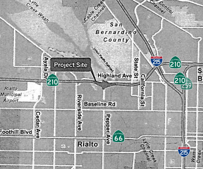
Waterman East Offramp Widening (08-SBd-210 R24.0)
In August 2022, the CTC approved the following
amendment into the SHOPP: 08-SBd-210 R24.0. PPNO 08-3019V; ProjID
0821000140; EA 1M560. Route 210 in the city of San Bernardino, at Waterman
Avenue eastbound offramp. Widen offramp to add right-turn lane
and modify traffic signals. Allocation ($ × 1,000): PA&ED $1,424;
PS&E $2,091; R/W Sup $133; Con Sup $3,093; R/W Cap $171; Const Cap:
$6,163; Total $13,075. Begin Const: 10/6/2025. Concurrent COS allocation
under Resolution FP-22-11; August 2022.
(Source: August 2022 CTC Agenda, Agenda Item
2.1a.(1a) #22)
In August 2022, the CTC approved the following
pre-construction phase allocation: $1,424,000. 08-SBd-210 R24.0. PPNO
08-3019V; ProjID 0821000140; EA 1M560. I-210 In the city of San
Bernardino, at Waterman Avenue eastbound offramp. Widen offramp to
add right-turn lane and modify traffic signals. Allocation: FY24-25
PA&ED $1,424,000. Concurrent Amendment under SHOPP Amendment 22H-003;
August 2022.
(Source: August 2022 CTC Agenda, Agenda Item 2.5b.(2a) #20)
In January 2024, the CTC revised the following project
in the 2022 SHOPP: 08-SBd-210 R24.0. PPNO 08-3019V; ProjID 0821000140; EA
1M560. Route 210 In the city of San Bernardino, at Waterman Avenue
eastbound offramp. Widen offramp to add right-turn lane, and
modify traffic signals, and install guardrail. Note:
Change scope to add guardrail to this project. Increase construction
support and capital due to added scope. This additional need will be
funded through Infrastructure Investment and Jobs Act (IIJA) funds.
Allocation Changes ($ × $1000) Con Sup $3,093 $3,133;
Const Cap $6,163 $6,364; REVISED TOTAL: $13,316.
(Source: January 2024 CTC Agenda, Agenda Item 2.1d #28)
Route 210 Lane Addition: Highland Ave to I-10 (~ SBD R25.0/R33.1)
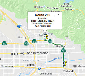 The 2018 STIP, approved at the CTC March 2018 meeting, appears to show completion of PPNO 0195N Rt 210 Lane addition, Highland Ave to I-10 (SBD
R25.0/R33.1). In San Bernardino. Construct one mixed flow-lane in each
direction from Highland Avenue (PM SBD R26.835) to San Bernardino Avenue
(~ SBD R32.374) and also construct auxiliary lanes at various locations
within the project limits. The project description notes that since
facility construction in the 1970s, the municipalities serviced by the
corridor have experienced accelerated growth. Areas along the corridor
have reached or exceeded the carrying capacity of the facility, resulting
in significant congestion at major local street interchanges. Corridor
improvements west of the project limits resulted in a lane imbalance
condition leading to bottlenecks within the unimproved segment. In order
to maintain desirable LOS and overall safety, it is proposed to add a
mixed flow lane in each direction, auxiliary lanes between Base Line and
5th Street, an acceleration lane at 5th Street E/B on-ramp and
deceleration lane at the Highland Avenue E/B off-ramp. Construction
supposedly was beginning in Jan 2018 and ending in August 2020. Total
allocated in the 2016 STIP was $25.5M.
The 2018 STIP, approved at the CTC March 2018 meeting, appears to show completion of PPNO 0195N Rt 210 Lane addition, Highland Ave to I-10 (SBD
R25.0/R33.1). In San Bernardino. Construct one mixed flow-lane in each
direction from Highland Avenue (PM SBD R26.835) to San Bernardino Avenue
(~ SBD R32.374) and also construct auxiliary lanes at various locations
within the project limits. The project description notes that since
facility construction in the 1970s, the municipalities serviced by the
corridor have experienced accelerated growth. Areas along the corridor
have reached or exceeded the carrying capacity of the facility, resulting
in significant congestion at major local street interchanges. Corridor
improvements west of the project limits resulted in a lane imbalance
condition leading to bottlenecks within the unimproved segment. In order
to maintain desirable LOS and overall safety, it is proposed to add a
mixed flow lane in each direction, auxiliary lanes between Base Line and
5th Street, an acceleration lane at 5th Street E/B on-ramp and
deceleration lane at the Highland Avenue E/B off-ramp. Construction
supposedly was beginning in Jan 2018 and ending in August 2020. Total
allocated in the 2016 STIP was $25.5M.
In October 2018, the CTC approved for future
consideration of funding the following project for which a Mitigated
Negative Declaration (MND) has been completed: Route 210 in San Bernardino
County (08-SBd-210, PM R25.00/R33.2). Widen and construct other roadway
improvements on a portion of Route 210 in the cities of Highland, San
Bernardino, and Redlands. (PPNO 0195N) This project is located on Route 210 in the cities of Highland, San Bernardino and Redlands in San
Bernardino County. The project proposes to widen Route 210. The project
also proposes to widen three of four existing interchange ramps. The
proposed project will address the need to reduce congestion and improve
operational efficiency by providing lane continuity with the existing
segments of Route 210, to the east and west of the project limits. This
proposed project is estimated to cost $183.7 million in construction
(capital and support) with funding currently programmed in the State
Transportation Improvement Program (STIP), SHOPP and local measure funds
for a combined amount of $138.4 million. Construction is estimated to
begin in 2019. The scope, as described for the preferred alternative, is
consistent with the project scope programmed by the Commission in the 2016
STIP.
(Source: October 2018 CTC Minutes, Agenda Item
2.2c.(1))
In May 2019, the CTC approved the following allocation
for a locally-administered STIP project: $25,000,000 08-SBD-210
R25.0/R33.1. Route 210 Widening. In San Bernardino County. Construct one
mixed flow-lane in each direction from Highland Avenue to San Bernardino
Avenue and also construct auxiliary lanes at various locations within the
project limits. Construction funding. PPNO 08-0195N. ProjID 0812000164.
(Source: May 2019 CTC Minutes, Agenda Item 2.5c.(2)
Item 3)
In February 2020, it was reported that the San Bernardino County Transportation Authority was breaking ground on on a long-awaited project to add two lanes to Route 210 and expand the Base Line Bridge. The project is actually three projects in one totaling $167 million. Approximately $99.9 million of the total cost will be funded by Measure I and $42.1 million will be funded by State Highway Operation and Protection Program funds. The interchange improvements will be a $31.7 million project with 42 percent, $18.4 million, funded by the city of Highland and the rest by Measure I funds. (Measure I, the half-cent sales tax approved by voters in 1989 and extended in 2004 to 2040.) According to the Transportation Authority, the project will add additional capacity in both directions between Sterling Avenue in San Bernardino and San Bernardino Avenue in Redlands. The new lanes will go in the middle. The Base Line Bridge in Highland will be expanded in both directions. The 6.1 miles of Route 210 from Sterling Avenue in San Bernardino (~ SBD R26.29) to San Bernardino Avenue in Redlands (~ SBD R32.355) are the only portion of the freeway without six lanes from where it starts in Santa Clarita to to where it ends in Redlands . Concentrations of housing and retail along the corridor have created significant bottlenecks at critical times during the day, according to the Transportation Authority. The eastbound and westbound onramps will be widened to three lanes. The westbound offramp will be widened to two lanes. The project also includes:
The project will not require the acquisition of new
permanent right of way. In general, the majority of the project
improvements will occur within existing Caltrans right of way. The project
is expected to take at least 3.5 years to complete. However, the
Transportation Authority is working with contractors to shorten the
duration of construction.
(Source: Highland News, 2/20/2020)
The 2020 STIP, approved at the March 2020 CTC Meeting,
continues the programmed funding of $25,000K for PPNO 0195N Rt 210 Lane
addition, Highland Av-Rt 10 (ext 6-18)(SHOPP).
(Source: March 2020 CTC Agenda, Item 4.7, 2020 STIP
Adopted 3/25/2020)
According to the Project Page in July 2020, the project, called the SR 210 Lane Addition/Base Line Interchange project, is designed to provide
increased traffic flow throughout the corridor. It will be built as one
project. There are two aspects to the project. First, to eliminate the
existing bottleneck and provide lane continuity, Route 210 will be widened
from Sterling Avenue to San Bernardino Avenue in the cities of San
Bernardino, Highland, and Redlands, as well as an unincorporated portion
of San Bernardino County. Second, the Base Line Interchange will also be
widened from Buckeye Street to Seine Avenue in the City of Highland.
Specifically, the project will add one mixed-flow lane in each direction
between Highland Avenue and San Bernardino Avenue, auxiliary lanes (merge
lanes) between Base Line and 5th Street, and an acceleration lane at the
5th Street eastbound ramp. The project also includes pavement
rehabilitation. Construction is expected to begin in February 2020, with
completion planned for Summer 2023. According to a construction report in
May 2020, bridge demolition was proceeding at Highland, Arden, San Creek,
and Victoria Ave. Daytime bridge construction activity was ongoing at 5th
Street, Pioneer Avenue, Victoria Avenue, and Base Line Street. Activities
includd pile driving, excavating the bridge abutments (structures at the
end of the bridges), and pouring concrete for the new bridge
abutments/footings.
(Source: SBCTA Construction Alert, Week of May 4; Project Website)
In September 2023, it was reported that the SR 210 Lane
Addition and Base Line Interchange Project was entering its final months
of construction. Crews have striped the Route 210 lanes to their final
configuration between Del Rosa Avenue and the I-10 freeway, adding one
mixed-flow lane in each direction between Highland Avenue and San
Bernardino Avenue, auxiliary lanes (merge lanes) between Base Line and 5th
Street/Greenspot Road, and an acceleration lane at the 5th
Street/Greenspot Road eastbound ramp. All work was anticipated to be
completed by the end of September 2023.
(Source: Project Worksite, 10/21/2023)
Greenspot Road Widening
In March 2013, the CTC approved $577,000 to widen ramps on northbound Route 210 and widen Greenspot Road (~ SBD R30.245) from 4 lanes to 6 lanes in Highland, on Route 210 at Greenspot Road, and on Greenspot Road from Route 210 to Boulder Avenue.
The SAFETEA-LU act, enacted in August 2005 as the reauthorization of TEA-21, provided the following expenditures on or near this route:
In June 2012, the CTC approved for future consideration of funding a project that will improve a section of Greenspot Road between Route 210 and Boulder Avenue, including Route 210 northbound termini ramps and the Boulder Avenue intersection in San Bernardino County. This is the interchange just to the E of the former Norton AFB (San Bernardino International Airport), where 5th Avenue turns into Greenspot Road.
As of 2008, the eastern terminus of Route 210 at Route 10 is no longer signed as Route 30/Route 330, Highland/Running Springs. It's now signed as Route 210/Route 330, Pasadena/Running Springs. Also, at the junction of Route 210 and Route 18, freeway entrance shields/overheads have been replaced with Route 210 shields. Other junctions (like Highland Ave/Fwy 210) still have Route 30 freeway entrance shields. The entire former Route 30 Fwy has Route 210 reassurance shields, but certain overheads still contain Route 30 signs (notably with the junction of Route 330), but they may be updated in early 2008.
It is believed that in September 2007 the entire route will be resubmitted to AASHTO to be redesignated as I-210 (clearly, this didn't happen).
 Commuter Lanes
Commuter lanes exist on this route between Route 134 and Sunflower Avenue. These were opened in December 1993, require two or more occupants, and are always in operation.
As of late 2007, there were some proposals to convert some future lanes E of I-605 into High-Occupancy Toll (HOT) lanes, as well as the lanes between Route 134 and I-605. In April 2008, the federal government offered Los Angeles County $213 million to convert these lanes to special, congestion-pricing toll lanes. In the proposed deal, the federal money would go toward the purchase of about 60 high-volume buses that would use the new toll lanes. That would free up MTA funds for creating the toll lanes. CTC approval would be required.
In the former Route 30 portion, HOV lanes are under construction or planned as follows:
 Naming
 The portion of this freeway from Route 5 to
Route 10 is named the "Foothill Freeway". It was officially named
by Senate Concurrent Resolution 29, Chapter 128, in 1991 (although the
name had been in use long before then). The first segment opened in 1955;
the last segment in 1999.
The portion of this freeway from Route 5 to
Route 10 is named the "Foothill Freeway". It was officially named
by Senate Concurrent Resolution 29, Chapter 128, in 1991 (although the
name had been in use long before then). The first segment opened in 1955;
the last segment in 1999.
(Image source: Pasadena Independent)
The entirety of Route 210 is named the Southern California Native American Freeway, or and equivalent the name developed by the department with the specified tribal entities. Caltrans is also required, through the erection of highway signs and appropriate markers, to provide recognition of the historical and cultural importance of the California tribes local to, or historically located in, the Counties of Los Angeles and San Bernardino. Caltrans is required to work with certain entities, including, but not limited to, California tribes local to, or historically located along, Route 210, to name Route 210 and to identify appropriate locations for signs to recognize tribal lands along Route 210 in the Counties of Los Angeles and San Bernardino. Caltrans will be erecting those signs and other appropriate markers at the appropriate locations on Route 210, as part of the department’s regularly scheduled replacement, modification, and maintenance of highway signs. The bill notes that Southern California tribal cultural affiliations along Route 210 include Cahuilla, Chumash, Gabrieleño/Tongva, Fernandeño/Tataviam, and Serrano. Named by AB 776, Chapter 543, Statutes of 2023, 10/8/2023.
 The portion of I-210 from Gould Avenue to
Orange Grove Boulevard in the County of Los Angeles (~ LA R20.59 to LA
R24.64) near where Jackie Robinson grew up is named the "Jackie
Robinson Memorial Highway". Jack Roosevelt “Jackie”
Robinson was born in January 1919, in Cairo, Georgia, to a family of
sharecroppers. Jackie Robinson and his four brothers†
(and their sister) were raised by a single mother who in 1920 managed to
move the family to Pasadena, California, and they became the first and
only black family on their block. Jackie Robinson was a natural athlete
and succeeded at John Muir High School and attended Pasadena City College
where he continued his athletic career by succeeding in basketball,
football, baseball, and track in 1938 when he was named the region’s
Most Valuable Player. Jackie Robinson transferred to the University of
California at Los Angeles (UCLA) in 1939 where he became the first Bruin
to letter in four sports: baseball, basketball, football, and track.
Jackie Robinson served as a second lieutenant in the United States Army
from 1942 to 1944 and was arrested and court martialed during boot camp
for refusing to move to the back of a bus. He was later acquitted of all
charges and received an honorable discharge. In early 1945, the Kansas
City Monarchs sent him a written offer to play professional baseball in
the Negro leagues. In all, Jackie Robinson played 47 games for the
Monarchs, hitting .387 with five home runs and registering 13 stolen
bases. In 1946, Jackie Robinson arrived at Daytona Beach, Florida, for
spring training with the all-white Montreal Royals of the Class Triple-A
International League and farm team for the Brooklyn Dodgers. On April 15,
1947, Jackie Robinson made his major league debut for the Brooklyn Dodgers
at Ebbets Field before a crowd of 26,623 spectators, including more than
14,000 black patrons, marking the first time ever that an African American
athlete played in major league baseball. Jackie Robinson faced the
constant onslaught from the public and from players objecting to playing
with him. Jackie Robinson stood firm and focused on beating the critics on
the field, despite the umpires who were supposed to protect all the
players, including Jackie Robinson, turning a blind eye to the abuse and
pitches aimed at his head that he endured, putting his life in danger.
Jackie Robinson finished the 1947 season having played in 151 games for
the Dodgers with a batting average of .297, an on-base percentage of .383,
and a .427 slugging percentage. He had 175 hits, scoring 125 runs,
including 31 doubles, 5 triples, and 12 home runs, driving in 48 runs for
the year. He led the league with 28 sacrifice hits and 29 stolen bases.
His cumulative performance earned him the inaugural Major League Baseball
Rookie of the Year Award. Jackie Robinson retired on January 5, 1957, from
professional baseball with an impressive career batting average of .311.
Jackie Robinson became a vocal champion for African American athletes,
civil rights, and other social and political causes, so that, after
baseball, he became active in business and continued his work as an
activist for social change and served on the board of the National
Association for the Advancement of Colored People (NAACP) until 1967.
Jackie Robinson was the first African American to be inducted into the
Baseball Hall of Fame in 1962. In 1972, the Dodgers retired his uniform
number of 42. His number, 42, is the only number to be retired by all of
baseball in honor of his accomplishments, including being the first
African American to break the color barrier. Jackie Robinson died from
heart problems and diabetes complications in October 1972, in Stamford,
Connecticut. Jackie Robinson’s life and legacy will be remembered as
one of the most important in American history. In 1997, the world
celebrated the 50th anniversary of his breaking major league
baseball’s color barrier, and in doing so, honored the man who stood
defiantly against those who would work against racial equality and
acknowledged the profound influence of one man’s life on American
culture;. Every year on the anniversary of Jackie Robinson’s
historic debut, all major league baseball teams across the nation
celebrate this milestone by wearing jerseys with only “42” on
the back. To this day Jackie Robinson is regarded as an inspiring example
of how to combat hate and discrimination in the world. Named by Assembly
Concurrent Resolution (ACR) 198, Res. Chapter 165, Statutes of 2016, on
September 1, 2016.
The portion of I-210 from Gould Avenue to
Orange Grove Boulevard in the County of Los Angeles (~ LA R20.59 to LA
R24.64) near where Jackie Robinson grew up is named the "Jackie
Robinson Memorial Highway". Jack Roosevelt “Jackie”
Robinson was born in January 1919, in Cairo, Georgia, to a family of
sharecroppers. Jackie Robinson and his four brothers†
(and their sister) were raised by a single mother who in 1920 managed to
move the family to Pasadena, California, and they became the first and
only black family on their block. Jackie Robinson was a natural athlete
and succeeded at John Muir High School and attended Pasadena City College
where he continued his athletic career by succeeding in basketball,
football, baseball, and track in 1938 when he was named the region’s
Most Valuable Player. Jackie Robinson transferred to the University of
California at Los Angeles (UCLA) in 1939 where he became the first Bruin
to letter in four sports: baseball, basketball, football, and track.
Jackie Robinson served as a second lieutenant in the United States Army
from 1942 to 1944 and was arrested and court martialed during boot camp
for refusing to move to the back of a bus. He was later acquitted of all
charges and received an honorable discharge. In early 1945, the Kansas
City Monarchs sent him a written offer to play professional baseball in
the Negro leagues. In all, Jackie Robinson played 47 games for the
Monarchs, hitting .387 with five home runs and registering 13 stolen
bases. In 1946, Jackie Robinson arrived at Daytona Beach, Florida, for
spring training with the all-white Montreal Royals of the Class Triple-A
International League and farm team for the Brooklyn Dodgers. On April 15,
1947, Jackie Robinson made his major league debut for the Brooklyn Dodgers
at Ebbets Field before a crowd of 26,623 spectators, including more than
14,000 black patrons, marking the first time ever that an African American
athlete played in major league baseball. Jackie Robinson faced the
constant onslaught from the public and from players objecting to playing
with him. Jackie Robinson stood firm and focused on beating the critics on
the field, despite the umpires who were supposed to protect all the
players, including Jackie Robinson, turning a blind eye to the abuse and
pitches aimed at his head that he endured, putting his life in danger.
Jackie Robinson finished the 1947 season having played in 151 games for
the Dodgers with a batting average of .297, an on-base percentage of .383,
and a .427 slugging percentage. He had 175 hits, scoring 125 runs,
including 31 doubles, 5 triples, and 12 home runs, driving in 48 runs for
the year. He led the league with 28 sacrifice hits and 29 stolen bases.
His cumulative performance earned him the inaugural Major League Baseball
Rookie of the Year Award. Jackie Robinson retired on January 5, 1957, from
professional baseball with an impressive career batting average of .311.
Jackie Robinson became a vocal champion for African American athletes,
civil rights, and other social and political causes, so that, after
baseball, he became active in business and continued his work as an
activist for social change and served on the board of the National
Association for the Advancement of Colored People (NAACP) until 1967.
Jackie Robinson was the first African American to be inducted into the
Baseball Hall of Fame in 1962. In 1972, the Dodgers retired his uniform
number of 42. His number, 42, is the only number to be retired by all of
baseball in honor of his accomplishments, including being the first
African American to break the color barrier. Jackie Robinson died from
heart problems and diabetes complications in October 1972, in Stamford,
Connecticut. Jackie Robinson’s life and legacy will be remembered as
one of the most important in American history. In 1997, the world
celebrated the 50th anniversary of his breaking major league
baseball’s color barrier, and in doing so, honored the man who stood
defiantly against those who would work against racial equality and
acknowledged the profound influence of one man’s life on American
culture;. Every year on the anniversary of Jackie Robinson’s
historic debut, all major league baseball teams across the nation
celebrate this milestone by wearing jerseys with only “42” on
the back. To this day Jackie Robinson is regarded as an inspiring example
of how to combat hate and discrimination in the world. Named by Assembly
Concurrent Resolution (ACR) 198, Res. Chapter 165, Statutes of 2016, on
September 1, 2016.
(Image source: Black Voice News; Tribune Democrat)
 † The world remembers Jackie. The world does not remember his brother, Mack
Robinson, who was equally important to the world and to Pasadena. At the
1936 Summer Olympics in Berlin, Jesse Owens demonstrated to Hitler that
athletic prowess wasn't exclusively Aryan. The runner who took silver in
the 200-meter sprint was also a black American. He was Mack Robinson, from
Pasadena, Jackie's brother. In 1914, the city opened a whites-only
swimming pool, called Brookside Plunge. After black protests, they allowed
blacks to use it once a week. Then the city drained it and refilled it
with fresh water. This is the Pasadena that Mack Robinson, Jackie
Robinson, and his family found when they arrived from Georgia in 1920.
Deserted by her husband and providing for five children, Mack’s
mother worked as a maid, and by 1923 saved enough money to buy a home. But
the home was in a white neighborhood. Some neighbors proposed buying them
out, but Mack’s sister later recalled the plan died out when a white
resident declared that the Robinsons were good neighbors. In the early
1930s, Mack Robinson went to Muir High School, but didn’t take part
in sports right away because of a heart problem. His mother signed a
waiver, and Mack persevered, helping Muir win the state championship in
1934. Mack had one year at Pasadena Junior College — now PCC —
before he won a regional Olympic qualifying. But it seemed unlikely that
Mack would even make it to the final trials, because they were in New
York, because Pasadena Junior College didn’t have the money to send
him to New York. A group of Pasadena businessmen stepped in and raised the
money, and Mack won his spot at the 1936 Olympics. On race day in Berlin,
Mack found himself in front of thousands of Germans, and just 15 feet from
Adolf Hitler. In the 200-meter, Mack finished less than a half second
behind Jesse Owens. And it’s even more impressive given the fact
that Mack was wearing old worn down spikes (Jessie Owens had new spikes
from Adidas). Gold medalist Jesse Owens got a ticker-tape parade in
Manhattan and $10,000 in cash. The winner of the bronze was recognized as
a hero in the Netherlands, where he was honored across the nation as the
“best sprinter of the white race.” Mack was ignored by
Pasadena when he returned. Mack won national collegiate and Amateur
Athletic Union track titles at the University of Oregon, but quit school
to go home and support his family. He got a job with the City of Pasadena
as a street sweeper and later dug ditches and sewer lines. Mack sometimes
swept the streets in his Olympic sweatshirt, his silver medal around his
neck. In 1970, Pasadena earned the dubious distinction of being the first
non-Southern city ordered to desegregate its schools. And Pasadena’s
public schools are where Mack Robinson found his true calling. He became a
truant officer at Muir and an activist against blight and crime in
northwest Pasadena. An LA Times article from 1983 referred to Mack as a
“crusader for law, order, decency, small children, good
neighborhoods and good government.” The 1980s saw Pasadena get its
first black mayor and Rose Queen, and Mack finally began to receive some
recognition for his athletic accomplishments. In 1984, he helped carry the
Olympic flag into the LA Coliseum for the opening ceremonies of the 1984
Olympics. At 101 Garfield Street in Pasadena, a bit S of where I-210 makes
its 90° turn, there is a memorial to the two Pasadena brothers, Jackie and Mack Robinson.
† The world remembers Jackie. The world does not remember his brother, Mack
Robinson, who was equally important to the world and to Pasadena. At the
1936 Summer Olympics in Berlin, Jesse Owens demonstrated to Hitler that
athletic prowess wasn't exclusively Aryan. The runner who took silver in
the 200-meter sprint was also a black American. He was Mack Robinson, from
Pasadena, Jackie's brother. In 1914, the city opened a whites-only
swimming pool, called Brookside Plunge. After black protests, they allowed
blacks to use it once a week. Then the city drained it and refilled it
with fresh water. This is the Pasadena that Mack Robinson, Jackie
Robinson, and his family found when they arrived from Georgia in 1920.
Deserted by her husband and providing for five children, Mack’s
mother worked as a maid, and by 1923 saved enough money to buy a home. But
the home was in a white neighborhood. Some neighbors proposed buying them
out, but Mack’s sister later recalled the plan died out when a white
resident declared that the Robinsons were good neighbors. In the early
1930s, Mack Robinson went to Muir High School, but didn’t take part
in sports right away because of a heart problem. His mother signed a
waiver, and Mack persevered, helping Muir win the state championship in
1934. Mack had one year at Pasadena Junior College — now PCC —
before he won a regional Olympic qualifying. But it seemed unlikely that
Mack would even make it to the final trials, because they were in New
York, because Pasadena Junior College didn’t have the money to send
him to New York. A group of Pasadena businessmen stepped in and raised the
money, and Mack won his spot at the 1936 Olympics. On race day in Berlin,
Mack found himself in front of thousands of Germans, and just 15 feet from
Adolf Hitler. In the 200-meter, Mack finished less than a half second
behind Jesse Owens. And it’s even more impressive given the fact
that Mack was wearing old worn down spikes (Jessie Owens had new spikes
from Adidas). Gold medalist Jesse Owens got a ticker-tape parade in
Manhattan and $10,000 in cash. The winner of the bronze was recognized as
a hero in the Netherlands, where he was honored across the nation as the
“best sprinter of the white race.” Mack was ignored by
Pasadena when he returned. Mack won national collegiate and Amateur
Athletic Union track titles at the University of Oregon, but quit school
to go home and support his family. He got a job with the City of Pasadena
as a street sweeper and later dug ditches and sewer lines. Mack sometimes
swept the streets in his Olympic sweatshirt, his silver medal around his
neck. In 1970, Pasadena earned the dubious distinction of being the first
non-Southern city ordered to desegregate its schools. And Pasadena’s
public schools are where Mack Robinson found his true calling. He became a
truant officer at Muir and an activist against blight and crime in
northwest Pasadena. An LA Times article from 1983 referred to Mack as a
“crusader for law, order, decency, small children, good
neighborhoods and good government.” The 1980s saw Pasadena get its
first black mayor and Rose Queen, and Mack finally began to receive some
recognition for his athletic accomplishments. In 1984, he helped carry the
Olympic flag into the LA Coliseum for the opening ceremonies of the 1984
Olympics. At 101 Garfield Street in Pasadena, a bit S of where I-210 makes
its 90° turn, there is a memorial to the two Pasadena brothers, Jackie and Mack Robinson.
(Source: KPCC Southern California Public Radio / Hidden History of LA, 5/19/2016); Image source: Atlas Obscura; Black Past)
 The portion of Route 210 from Allen Avenue on the west to Rosemead Boulevard
on the east in the City of Pasadena (~ LA R27.435 to LA R29.496) is
officially designated the "Pasadena Police Agent Richard Morris
Memorial Highway". It was named in memory of Pasadena Police Agent
Richard Frank Morris, who was born in 1940 and grew up in Temple City and
Rosemead, attending Muscatel Junior High School and Rosemead High School
in the San Gabriel Valley. Between 1958 and 1960, Richard Morris attended
Mt. San Antonio College, graduating with an Associate’s Degree in
Political Science prior to enlisting in the United State Marine Corps
Reserve. Richard Morris directed his commitment to public service and
sense of adventure into a career in police work, joining the Pasadena
Police Department in February of 1962 and entering the basic training
academy. Richard Morris graduated from the police academy training program
on March 30, 1962, and began his career as a police officer in the City of
Pasadena. Richard Morris was promoted to the rank of Police Agent in the
Detective, Narcotics Unit in February of 1968. Throughout his tenure with
the Pasadena Police Department, Police Agent Morris was regarded as a
rising star within the police force. Police Agent Morris was protecting
the ideals and values of the Pasadena community when he was shot and
killed in the line of duty on March 13, 1969, while pursuing an assault
suspect. Police Agent Morris is remembered within the City of Pasadena for
his honor, courage, and commitment to the residents of the City of
Pasadena. It was named by Assembly Concurrent Resolution 170, Resolution
Chapter 181, 09/11/14.
The portion of Route 210 from Allen Avenue on the west to Rosemead Boulevard
on the east in the City of Pasadena (~ LA R27.435 to LA R29.496) is
officially designated the "Pasadena Police Agent Richard Morris
Memorial Highway". It was named in memory of Pasadena Police Agent
Richard Frank Morris, who was born in 1940 and grew up in Temple City and
Rosemead, attending Muscatel Junior High School and Rosemead High School
in the San Gabriel Valley. Between 1958 and 1960, Richard Morris attended
Mt. San Antonio College, graduating with an Associate’s Degree in
Political Science prior to enlisting in the United State Marine Corps
Reserve. Richard Morris directed his commitment to public service and
sense of adventure into a career in police work, joining the Pasadena
Police Department in February of 1962 and entering the basic training
academy. Richard Morris graduated from the police academy training program
on March 30, 1962, and began his career as a police officer in the City of
Pasadena. Richard Morris was promoted to the rank of Police Agent in the
Detective, Narcotics Unit in February of 1968. Throughout his tenure with
the Pasadena Police Department, Police Agent Morris was regarded as a
rising star within the police force. Police Agent Morris was protecting
the ideals and values of the Pasadena community when he was shot and
killed in the line of duty on March 13, 1969, while pursuing an assault
suspect. Police Agent Morris is remembered within the City of Pasadena for
his honor, courage, and commitment to the residents of the City of
Pasadena. It was named by Assembly Concurrent Resolution 170, Resolution
Chapter 181, 09/11/14.
(Image source: Vasken Gourdikian on Twitter; Pasadena Police Officers Assn)
 The portion of the route from the City of Duarte to I-15 (~ LA R35.271 to SBD 11.129) is
named the William H. Lancaster Memorial Highway. William H.
("Bill") Lancaster was born in Bakersfield. He was elected to the Duarte
City Council in 1958 and reelected in 1962, and served three terms as the
city's mayor. He was elected to the California Assembly in 1972 where he
served on the Assembly Committee on Rules, the Assembly Committee on
Transportation, and the Assembly Committee on Local Government. He was
honored as Legislator of the Year by the League of California Cities in
1991 for his efforts to protect city finances. During his tenure on the
Assembly Committee on Transportation, Bill Lancaster fought for the
extension of Route 210. He retired from the Assembly in 1992. Named by
Assembly Concurrent Resolution 2, Chapter 76, 6/27/2003.
The portion of the route from the City of Duarte to I-15 (~ LA R35.271 to SBD 11.129) is
named the William H. Lancaster Memorial Highway. William H.
("Bill") Lancaster was born in Bakersfield. He was elected to the Duarte
City Council in 1958 and reelected in 1962, and served three terms as the
city's mayor. He was elected to the California Assembly in 1972 where he
served on the Assembly Committee on Rules, the Assembly Committee on
Transportation, and the Assembly Committee on Local Government. He was
honored as Legislator of the Year by the League of California Cities in
1991 for his efforts to protect city finances. During his tenure on the
Assembly Committee on Transportation, Bill Lancaster fought for the
extension of Route 210. He retired from the Assembly in 1992. Named by
Assembly Concurrent Resolution 2, Chapter 76, 6/27/2003.
(Image source: AARoads)
 The portion of this route from the existing interchange of Route 210
 30 and Route 215, in the City
of San Bernardino at SBD 21.84, to the existing interchange of Route 210 30
and Route 10, in the City of Redlands at SBD 33, is officially named the "Martin
A. Matich Highway". This segment was named in honor of Martin A.
Matich. Matich served as a Colton City Council member from 1956 to 1958,
and served as the mayor of the City of Colton from 1958 to 1960. He also
served since 1950 as the president and then the chairman of Matich
Corporation, which has been a California company since 1918 and which was
founded by his father, John Matich; the company is a leader in providing
the highways, airports, and public works projects. He also served his
community and state as a member of the Loma Linda University Medical
Center, the Loma Linda University Children's Hospital, and the St.
Bernardine's Medical Center; as a member of the board of the National
Orange Show Foundation; as a member of the board of the Boy Scouts of
America-Inland Empire Council; as a member of the board of the Girl Scouts
of America-San Gorgonio Council; and as a member and past director of the
San Bernardino Chamber of Commerce. He has provided endowed scholarships
to the University of Notre Dame under the names of the John Matich
Undergraduate Scholarship and the Joyce Athletic Scholarship, and has
provided a scholarship to the University of Redlands in the name of
Williamina Matich. He also had a constant record of leadership on state
transportation issues and, in particular, long-term support for the
construction of the Foothill Freeway. Named by Assembly Concurrent
Resolution (ACR) 156, Resolution Chapter 144, on 9/12/2006.
(Image source: Matich Corporation; Bobbitt Memorial Chapel)
 Named Structures
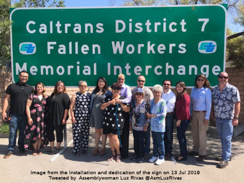 The interchange at I-210 and I-5 (LA 5
R43.904; LA 210 R0.000) in the County of Los Angeles is designated as the
"Caltrans District 7 Fallen Workers Memorial Interchange".
Highway construction is one of the most dangerous occupations in the
United States. The risk of death is seven times higher for highway workers
than for other workers, according to a study conducted by the Occupational
Safety and Health Administration of the United States Department of Labor.
The Department of Transportation (Caltrans) has lost 185 employees since
1921. On average, 1,000 Caltrans vehicles are struck each year, and, in
addition to the danger to workers, an estimated 85 to 90 percent of people
who are killed in highway work zones are drivers and their passengers. The
following workers in District 7 are memorialized with this designation:
The interchange at I-210 and I-5 (LA 5
R43.904; LA 210 R0.000) in the County of Los Angeles is designated as the
"Caltrans District 7 Fallen Workers Memorial Interchange".
Highway construction is one of the most dangerous occupations in the
United States. The risk of death is seven times higher for highway workers
than for other workers, according to a study conducted by the Occupational
Safety and Health Administration of the United States Department of Labor.
The Department of Transportation (Caltrans) has lost 185 employees since
1921. On average, 1,000 Caltrans vehicles are struck each year, and, in
addition to the danger to workers, an estimated 85 to 90 percent of people
who are killed in highway work zones are drivers and their passengers. The
following workers in District 7 are memorialized with this designation:
In addition to law enforcement and Department of California Highway Patrol officers, contracted highway workers are also at risk of death. The latest data shows that speeding was a factor in more than 35 percent of all fatal work zone crashes, and most work zone fatalities are the result of rear-end collisions caused by driver distraction, inattention, or aggressive driving. Caltrans has adopted a “Slow for the Cone Zone” campaign to raise public awareness and to ask motorists to be alert, slow down, allow extra following room, expect sudden stops, never drive impaired, and avoid distractions, including the use of cell phones, in highway work zones. Fines are doubled in highway work zones and can easily total $1,000 or more for drivers who speed, drive aggressively, text, are otherwise distracted, or cause collisions in a highway work zone. Named by Assembly Concurrent Resolution (ACR) 263, Res. Chapter 220, 9/11/2018.
In November 2018, it was reported that the interchange
was formally dedicated as the memorial. The dedication ceremony video is available on YouTube. State Assemblymember Luz Rivas, who authored a resolution to memorialize the interchange stated, “The
Caltrans District 7 Fallen Workers Memorial Interchange honors the
legacies of those who lost their lives building, maintaining, and
operating one of California’s most valuable assets: its
transportation system.” The back of the memorial sign contains
messages from the families of the fallen.
(Source: Caltrans District 7, 11/27/2018; Image from Tweet by Assemblywoman Luz Rivas, @AsmLuzRivas)
 The North Arroyo Boulevard Overcrossing (LA R22.495) on I-210
is named the "Arroyo Seco Victims Memorial Overcrossing". Few
people know about the Foothill Bridge collapse that occurred on the
Foothill Freeway, which consists of contiguous segments of I-210 and Route 210 near Devil’s Gate in the City of Pasadena (hereafter the
Foothill Freeway) on Tuesday, October 17, 1972, but the memory remains for
the families of those who died during that tragedy. When the bridge
collapsed over the Arroyo Seco, six workers who were working on the bridge
were killed. The bridge was being built to pass the Foothill Freeway over
the Arroyo Seco below Devil’s Gate Reservoir, near Arroyo Boulevard
and Rosemont Avenue in the City of Pasadena. At approximately 1:30 p.m. on
October 17, 1972, faulty scaffolding on a 60-foot stretch of the Foothill
Freeway collapsed while concrete was being poured for the bridge
construction, crushing victims who were under the construction at the time
of the collapse. Between 17 and 35 workers were on the job when the bridge
collapsed and many leaped into action to assist others or run to safety
.An army of 500 rescue workers labored throughout the night to locate
missing workers who were buried under six feet of concrete. The six
workmen killed while working on the bridge included Jesus Jose Quinonos of
Pasadena, Richard Calleros of Santa Ana, Frank Scharf of Upland, Robert
Queenan of Alhambra, Hector Delgado Gonzalez of Pico Rivera, and James
Glass of Los Angeles. The bodies of three of the workmen who were entombed
in a 100-ton mass of concrete were found by rescue workers who used
jackhammers to rip through the debris of a fallen 100-foot-high freeway
bridge section. The other three workmen were killed when building
materials plummeted from 100 feet high to the ground, carrying dozens of
workers to the ground. A total of 21 men were seriously injured with six
of them listed in critical condition. Search and rescue crews,
construction workers, fire fighters, and police officers from nearby
cities and the County of Los Angeles assisted in the rescue efforts. The
bridge collapse caused an unexpected tragedy that created intense pain for
families of those who were injured or died as a result. The overcrossing
is named as an appropriate tribute in honor of the six men who lost their
lives over the Arroyo Seco. Named by Assembly Concurrent Resolution (ACR)
250, Res. Chapter 208, 9/7/2018.
The North Arroyo Boulevard Overcrossing (LA R22.495) on I-210
is named the "Arroyo Seco Victims Memorial Overcrossing". Few
people know about the Foothill Bridge collapse that occurred on the
Foothill Freeway, which consists of contiguous segments of I-210 and Route 210 near Devil’s Gate in the City of Pasadena (hereafter the
Foothill Freeway) on Tuesday, October 17, 1972, but the memory remains for
the families of those who died during that tragedy. When the bridge
collapsed over the Arroyo Seco, six workers who were working on the bridge
were killed. The bridge was being built to pass the Foothill Freeway over
the Arroyo Seco below Devil’s Gate Reservoir, near Arroyo Boulevard
and Rosemont Avenue in the City of Pasadena. At approximately 1:30 p.m. on
October 17, 1972, faulty scaffolding on a 60-foot stretch of the Foothill
Freeway collapsed while concrete was being poured for the bridge
construction, crushing victims who were under the construction at the time
of the collapse. Between 17 and 35 workers were on the job when the bridge
collapsed and many leaped into action to assist others or run to safety
.An army of 500 rescue workers labored throughout the night to locate
missing workers who were buried under six feet of concrete. The six
workmen killed while working on the bridge included Jesus Jose Quinonos of
Pasadena, Richard Calleros of Santa Ana, Frank Scharf of Upland, Robert
Queenan of Alhambra, Hector Delgado Gonzalez of Pico Rivera, and James
Glass of Los Angeles. The bodies of three of the workmen who were entombed
in a 100-ton mass of concrete were found by rescue workers who used
jackhammers to rip through the debris of a fallen 100-foot-high freeway
bridge section. The other three workmen were killed when building
materials plummeted from 100 feet high to the ground, carrying dozens of
workers to the ground. A total of 21 men were seriously injured with six
of them listed in critical condition. Search and rescue crews,
construction workers, fire fighters, and police officers from nearby
cities and the County of Los Angeles assisted in the rescue efforts. The
bridge collapse caused an unexpected tragedy that created intense pain for
families of those who were injured or died as a result. The overcrossing
is named as an appropriate tribute in honor of the six men who lost their
lives over the Arroyo Seco. Named by Assembly Concurrent Resolution (ACR)
250, Res. Chapter 208, 9/7/2018.
(Image source: Pasadena Star News)
 The interchange of I-605 and I-210
(~ LA R36.193) is named the Los Angeles County Deputy Sheriff David W.
March Memorial Interchange. It was named in memory of Deputy David
W. March of the Los Angeles County Sheriff's Department, who was killed in
the line of duty at the age of 33 on April 29, 2002, in Irwindale while
conducting a "routine" traffic stop. The suspect, Armando "Chato" Garcia,
a Mexican citizen who had previously been deported multiple times, had
told friends that he wanted to kill a police officer during a traffic
stop. The suspect intentionally got stopped and waited for Deputy March to
get in front of his patrol car so he could open fire, as Deputy March
would have no place to take cover. Deputy March was shot several times in
the head and chest. The suspect, who was identified shortly after the
shooting, fled to Mexico where he remained for four years. On Feb. 23,
2006, the suspect was arrested in Mexico by U.S. Marshals and Mexican
federal agents following a joint investigation. He was extradited back to
California and on March 2, 2007. He plead guilty to second-degree murder
and was sentenced to life in prison without the possibility of parole.
Dep. Sheriff March was a longtime resident of Santa Clarita Valley and a
1988 graduate of Canyon High School where he played football and baseball.
He served seven years as a law enforcement officer. It was named by
Assembly Concurrent Resolution 142, July 16, 2004. Chapter 122.
The interchange of I-605 and I-210
(~ LA R36.193) is named the Los Angeles County Deputy Sheriff David W.
March Memorial Interchange. It was named in memory of Deputy David
W. March of the Los Angeles County Sheriff's Department, who was killed in
the line of duty at the age of 33 on April 29, 2002, in Irwindale while
conducting a "routine" traffic stop. The suspect, Armando "Chato" Garcia,
a Mexican citizen who had previously been deported multiple times, had
told friends that he wanted to kill a police officer during a traffic
stop. The suspect intentionally got stopped and waited for Deputy March to
get in front of his patrol car so he could open fire, as Deputy March
would have no place to take cover. Deputy March was shot several times in
the head and chest. The suspect, who was identified shortly after the
shooting, fled to Mexico where he remained for four years. On Feb. 23,
2006, the suspect was arrested in Mexico by U.S. Marshals and Mexican
federal agents following a joint investigation. He was extradited back to
California and on March 2, 2007. He plead guilty to second-degree murder
and was sentenced to life in prison without the possibility of parole.
Dep. Sheriff March was a longtime resident of Santa Clarita Valley and a
1988 graduate of Canyon High School where he played football and baseball.
He served seven years as a law enforcement officer. It was named by
Assembly Concurrent Resolution 142, July 16, 2004. Chapter 122.
(Image source: SCV History)
 The interchange with Route 57
(i.e., the former Route 30/Route 210 interchange) (~ LA R43.999) is named
the "Police Officer Louie Pompei Memorial Interchange". Louis
("Louie") A. Pompei was born August 4, 1964, in Shenandoah, Pennsylvania.
He was a physical fitness buff, and body builder, who earned a silver
medal in the bodybuilding competition of the 1994 California Police
Olympics, and who was a runner on the Glendora-Monrovia-Arcadia Police
relay team, which annually competes in the Baker to Vegas 120-mile
Challenge Cup relay race. He graduated from Mansfield University,
Pennsylvania, in 1986 with a BA degree in Criminal Justice Administration;
and was hired as a Police Officer trainee by the Glendora Police
Department on October 12, 1987. He graduated from the Los Angeles County
Sheriff's Academy on March 4, 1988, and worked in the Patrol Division of
the Glendora Police Department from 1988 to 1992 where he developed an
enthusiasm for working narcotics cases, working as a narcotics
investigator in the Detective Division of the Glendora Police Department
from 1992 to 1995. During this time, he was assigned to a position with
L.A. IMPACT, a major crimes multijurisdictional task force, composed of
officers from agencies throughout the county, primarily dedicated to
investigating major drug suppliers through southern California. On June 9,
2002, while off duty in a Vons Market in Via Verde, Officer Pompei
attempted to stop an armed robbery takeover in which a box boy was being
pistol whipped, and was killed in a fire fight. His colleagues remember
him for his love of life, contagious enthusiasm, positive and outgoing
attitude, and generous, helpful, and dependable personality. Named by
Senate Concurrent Resolution 64, Chapter 105, on August 8, 2002.
Surprisingly, the resolution refers to the Route 30/Route 210 interchange,
even thought at the time of passage, Route 30 no longer existed. I guess
the legislative analyst missed finding that error.
The interchange with Route 57
(i.e., the former Route 30/Route 210 interchange) (~ LA R43.999) is named
the "Police Officer Louie Pompei Memorial Interchange". Louis
("Louie") A. Pompei was born August 4, 1964, in Shenandoah, Pennsylvania.
He was a physical fitness buff, and body builder, who earned a silver
medal in the bodybuilding competition of the 1994 California Police
Olympics, and who was a runner on the Glendora-Monrovia-Arcadia Police
relay team, which annually competes in the Baker to Vegas 120-mile
Challenge Cup relay race. He graduated from Mansfield University,
Pennsylvania, in 1986 with a BA degree in Criminal Justice Administration;
and was hired as a Police Officer trainee by the Glendora Police
Department on October 12, 1987. He graduated from the Los Angeles County
Sheriff's Academy on March 4, 1988, and worked in the Patrol Division of
the Glendora Police Department from 1988 to 1992 where he developed an
enthusiasm for working narcotics cases, working as a narcotics
investigator in the Detective Division of the Glendora Police Department
from 1992 to 1995. During this time, he was assigned to a position with
L.A. IMPACT, a major crimes multijurisdictional task force, composed of
officers from agencies throughout the county, primarily dedicated to
investigating major drug suppliers through southern California. On June 9,
2002, while off duty in a Vons Market in Via Verde, Officer Pompei
attempted to stop an armed robbery takeover in which a box boy was being
pistol whipped, and was killed in a fire fight. His colleagues remember
him for his love of life, contagious enthusiasm, positive and outgoing
attitude, and generous, helpful, and dependable personality. Named by
Senate Concurrent Resolution 64, Chapter 105, on August 8, 2002.
Surprisingly, the resolution refers to the Route 30/Route 210 interchange,
even thought at the time of passage, Route 30 no longer existed. I guess
the legislative analyst missed finding that error.
(Image source: Patch)
 The overcrossing on State Route 210 at Archibald Avenue (~ SBD 5.889) in the City of Rancho
Cucamonga is named the “Senator Bob Dutton Memorial Overcrossing”.
Bob Dutton was born in the City of Lincoln, Nebraska, in October 1950 and
moved to California in 1969, where he served in the United States Army
Reserve and California Air National Guard. Dutton dedicated his life
to the people of the City of Rancho Cucamonga and the County of San
Bernardino, serving over 50 years in the community, where he was nicknamed
“RC Bob”. Dutton opened a real estate investment and
management firm, Dutton & Associates, Inc., with his father, Ted
Dutton, located in the City of Rancho Cucamonga and served as a board
member and president of the Rancho Cucamonga Chamber of Commerce. Dutton
was elected to the Rancho Cucamonga City Council in 1998, where he led the
fight to eliminate the city’s utility tax, which was successfully
abolished in 2001. Dutton was then elected to the California State
Assembly to serve the 63rd Assembly District in 2002 and was
then elected to the California State Senate to serve the 31st
Senate District in 2004, where he served as the Vice Chair of the Senate
Committee on Rules and the Senate Committee on Budget and Fiscal Review,
took the lead on housing and transportation issues. As a state legislator,
Senator Dutton led the effort to pardon Snickers the Bear, an orphaned
black bear in his district, by hand delivering the letters of local
schoolchildren to then-Governor Arnold Schwarzenegger, requesting Snickers
be returned from a state facility to Wildhaven Ranch Wildlife Sanctuary
and united with her companion, Little Bear, a fellow orphaned black bear.
Dutton was last elected to serve as the County of San Bernardino’s
Assessor-Recorder-Clerk in 2014 and was appointed County Clerk where he
led a department of 250 county employees. Dutton received many honors,
including being named Legislator of the Year by the League of California
Cities, the California State Sheriffs’ Association, the California
Alliance of Small Business Associations, and the California Small Business
Roundtable; he also served many community and civic organizations,
including the YMCA, the American Red Cross, the Rancho Cucamonga Chamber
of Commerce, the Community Foundation, and the San Bernardino County
Sheriff’s Council. Dutton died at 71 years of age, on July 23, 2022.
Named by SCR 59, Res. Chapter 1, Statutes of 2024, 1/18/2024.
The overcrossing on State Route 210 at Archibald Avenue (~ SBD 5.889) in the City of Rancho
Cucamonga is named the “Senator Bob Dutton Memorial Overcrossing”.
Bob Dutton was born in the City of Lincoln, Nebraska, in October 1950 and
moved to California in 1969, where he served in the United States Army
Reserve and California Air National Guard. Dutton dedicated his life
to the people of the City of Rancho Cucamonga and the County of San
Bernardino, serving over 50 years in the community, where he was nicknamed
“RC Bob”. Dutton opened a real estate investment and
management firm, Dutton & Associates, Inc., with his father, Ted
Dutton, located in the City of Rancho Cucamonga and served as a board
member and president of the Rancho Cucamonga Chamber of Commerce. Dutton
was elected to the Rancho Cucamonga City Council in 1998, where he led the
fight to eliminate the city’s utility tax, which was successfully
abolished in 2001. Dutton was then elected to the California State
Assembly to serve the 63rd Assembly District in 2002 and was
then elected to the California State Senate to serve the 31st
Senate District in 2004, where he served as the Vice Chair of the Senate
Committee on Rules and the Senate Committee on Budget and Fiscal Review,
took the lead on housing and transportation issues. As a state legislator,
Senator Dutton led the effort to pardon Snickers the Bear, an orphaned
black bear in his district, by hand delivering the letters of local
schoolchildren to then-Governor Arnold Schwarzenegger, requesting Snickers
be returned from a state facility to Wildhaven Ranch Wildlife Sanctuary
and united with her companion, Little Bear, a fellow orphaned black bear.
Dutton was last elected to serve as the County of San Bernardino’s
Assessor-Recorder-Clerk in 2014 and was appointed County Clerk where he
led a department of 250 county employees. Dutton received many honors,
including being named Legislator of the Year by the League of California
Cities, the California State Sheriffs’ Association, the California
Alliance of Small Business Associations, and the California Small Business
Roundtable; he also served many community and civic organizations,
including the YMCA, the American Red Cross, the Rancho Cucamonga Chamber
of Commerce, the Community Foundation, and the San Bernardino County
Sheriff’s Council. Dutton died at 71 years of age, on July 23, 2022.
Named by SCR 59, Res. Chapter 1, Statutes of 2024, 1/18/2024.
(Image source: San Bernardino County, 7/23/2022)
 The highway overcrossing at the I-210 interchange at Haven Avenue, PM SBD 6.913 in the County of
San Bernardino, is named the “Lance Cpl. Dylan Merola Memorial
Highway Overcrossing”. It was named in memory of Lance Cpl.
Dylan Ryan Merola, who was born in Upland, California, and grew up in
Rancho Cucamonga, California. As a child, Merola always wore military
attire and dreamed of becoming a United States Marine to make a difference
in the world. Merola graduated from Los Osos High School in Rancho
Cucamonga, California, in 2019; and joined the United States Marine Corps
after graduation, with plans, after his service to his country concluded,
to attend college and study engineering. Merola’s decision to go
into the military was motivated by his two great-grandfathers who were
Korean War veterans. Merola was assigned to the 2nd Battalion, 1st Marine
Regiment, 1st Marine Division, I Marine Expeditionary Force out of Camp
Pendleton, California. Merola was 1 of 13 United States Service Members
killed in the attack on Hamid Karzai International Airport in Kabul,
Afghanistan, on August 26, 2021, less than two weeks after he was deployed
in Kabul. Merola was posthumously awarded the Purple Heart medal for his
sacrifice and bravery. Named by Assembly Resolution ACR 139, Res. Chapter 129, 08/19/22.
The highway overcrossing at the I-210 interchange at Haven Avenue, PM SBD 6.913 in the County of
San Bernardino, is named the “Lance Cpl. Dylan Merola Memorial
Highway Overcrossing”. It was named in memory of Lance Cpl.
Dylan Ryan Merola, who was born in Upland, California, and grew up in
Rancho Cucamonga, California. As a child, Merola always wore military
attire and dreamed of becoming a United States Marine to make a difference
in the world. Merola graduated from Los Osos High School in Rancho
Cucamonga, California, in 2019; and joined the United States Marine Corps
after graduation, with plans, after his service to his country concluded,
to attend college and study engineering. Merola’s decision to go
into the military was motivated by his two great-grandfathers who were
Korean War veterans. Merola was assigned to the 2nd Battalion, 1st Marine
Regiment, 1st Marine Division, I Marine Expeditionary Force out of Camp
Pendleton, California. Merola was 1 of 13 United States Service Members
killed in the attack on Hamid Karzai International Airport in Kabul,
Afghanistan, on August 26, 2021, less than two weeks after he was deployed
in Kabul. Merola was posthumously awarded the Purple Heart medal for his
sacrifice and bravery. Named by Assembly Resolution ACR 139, Res. Chapter 129, 08/19/22.
(Image source: KVCR 91.9/US Marines)
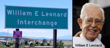 The I-15/Route 210 interchange (~ SBD
11.129) is named the "William E. Leonard Interchange". William E.
Leonard served as Chairman for both the California Highway Commission and
the California Transportation Commission (1973-1974). In 1946, William E.
Leonard joined Leonard Realty and Building Co., a firm established by his
grandfather in 1905. By the early 1960s, he was a leading developer and a
founding director of Inland Action, Inc., a group of business, government
and education leaders whose positive effect continues in the region to
this day. Over the years, Mr. Leonard's civic influence has included
chairing the California Highway Commission (1973-77) and the California
Transportation Commission (1985-93). He was active with the National
Orange Show, serving as its president in 1966. He was also a member of the
State Athletic Commission and the University of California at Riverside
Foundation. He also chaired the San Bernardino Valley College Foundation
Board and served as a trustee of the St. Bernardine's Hospital Foundation,
in addition to work on many other local boards and charities. An
investment and business consultant in recent years, he has been active
with the Inland Valley Development Authority's work to convert the former
Norton Air Force Base to a technology park and other private uses. A
veteran of World War II, he served in the U.S. Army in the Pacific
Theater, achieving the rank of First Lieutenant. He later received his
bachelor's degree in business administration from the University of
California, Berkeley. California State University, San Bernardino, honored
him and his wife in 2006 by naming the university's new federally funded
center the "William and Barbara Leonard University Transportation Center.
Named by Senate Concurrent Resolution 104, Resolution Chapter 171, in
1998.
The I-15/Route 210 interchange (~ SBD
11.129) is named the "William E. Leonard Interchange". William E.
Leonard served as Chairman for both the California Highway Commission and
the California Transportation Commission (1973-1974). In 1946, William E.
Leonard joined Leonard Realty and Building Co., a firm established by his
grandfather in 1905. By the early 1960s, he was a leading developer and a
founding director of Inland Action, Inc., a group of business, government
and education leaders whose positive effect continues in the region to
this day. Over the years, Mr. Leonard's civic influence has included
chairing the California Highway Commission (1973-77) and the California
Transportation Commission (1985-93). He was active with the National
Orange Show, serving as its president in 1966. He was also a member of the
State Athletic Commission and the University of California at Riverside
Foundation. He also chaired the San Bernardino Valley College Foundation
Board and served as a trustee of the St. Bernardine's Hospital Foundation,
in addition to work on many other local boards and charities. An
investment and business consultant in recent years, he has been active
with the Inland Valley Development Authority's work to convert the former
Norton Air Force Base to a technology park and other private uses. A
veteran of World War II, he served in the U.S. Army in the Pacific
Theater, achieving the rank of First Lieutenant. He later received his
bachelor's degree in business administration from the University of
California, Berkeley. California State University, San Bernardino, honored
him and his wife in 2006 by naming the university's new federally funded
center the "William and Barbara Leonard University Transportation Center.
Named by Senate Concurrent Resolution 104, Resolution Chapter 171, in
1998.
(Image / biographic information source: Find a Grave; CSUSBHonorary
Degree page)
 The Ayala Drive overcrossing at PM SBD 17.437 on Route 210 in the County of
San Bernardino is named the “Scott “Buckshot”
Schwingel Memorial Overcrossing”. It was named in memory of
Scott “Buckshot” Schwingel, who was born in the City of
Riverside. At age 19, Scott moved to Lake Arrowhead. At age 21, Scott came
across a traffic accident, which led him to ultimately decide to become a
firefighter. Scott went to paramedic school in Victor Valley, became an
emergency medical technician (EMT), and shortly thereafter, began testing
for fire departments. Scott was hired by the Rialto Fire Department as a
firefighter paramedic in 2001. During his career, Scott proudly served the
citizens of the City of Rialto as a steadfast embodiment of the Rialto
Fire Department’s motto: “Dedicated to Excellence, Service
with Compassion”. Scott was well known for his lighthearted approach
to the challenging and demanding firefighter profession, and was a model
firefighter that many of the younger generation’s firefighters would
look to for guidance. Scott was an extremely motivated and determined
individual, and with that determination, he was promoted to the rank of
fire engineer in 2006. Scott was diagnosed with job-related colon cancer
that resulted in him passing away on January 27, 2018. Scott continued to
provide service to the citizens of the City of Rialto throughout his
battle with cancer. During his 16-year career, Scott earned the Rialto
Fire Department Life Saving Award, and was awarded the Rialto Fire
Department’s Firefighter of the Year Award in 2017. Named by ACR 7,
Resolution Chapter 126, Statutes of 2023 on 07/20/23.
The Ayala Drive overcrossing at PM SBD 17.437 on Route 210 in the County of
San Bernardino is named the “Scott “Buckshot”
Schwingel Memorial Overcrossing”. It was named in memory of
Scott “Buckshot” Schwingel, who was born in the City of
Riverside. At age 19, Scott moved to Lake Arrowhead. At age 21, Scott came
across a traffic accident, which led him to ultimately decide to become a
firefighter. Scott went to paramedic school in Victor Valley, became an
emergency medical technician (EMT), and shortly thereafter, began testing
for fire departments. Scott was hired by the Rialto Fire Department as a
firefighter paramedic in 2001. During his career, Scott proudly served the
citizens of the City of Rialto as a steadfast embodiment of the Rialto
Fire Department’s motto: “Dedicated to Excellence, Service
with Compassion”. Scott was well known for his lighthearted approach
to the challenging and demanding firefighter profession, and was a model
firefighter that many of the younger generation’s firefighters would
look to for guidance. Scott was an extremely motivated and determined
individual, and with that determination, he was promoted to the rank of
fire engineer in 2006. Scott was diagnosed with job-related colon cancer
that resulted in him passing away on January 27, 2018. Scott continued to
provide service to the citizens of the City of Rialto throughout his
battle with cancer. During his 16-year career, Scott earned the Rialto
Fire Department Life Saving Award, and was awarded the Rialto Fire
Department’s Firefighter of the Year Award in 2017. Named by ACR 7,
Resolution Chapter 126, Statutes of 2023 on 07/20/23.
(Image source: Sean Grayson on X/Twitter)
 The Route 210/I-215 interchange (~ SBD
R21.789) is named the "Gary Moon Memorial Interchange". This
interchange was named in memory of Gary Moon, whoserved with utmost
distinction as the Director of Freeway Construction for San Bernardino
Associated Governments (SANBAG) between October 1990 and March 2003. Mr.
Moon earned the respect of the public, elected officials and colleagues
for his problem solving abilities, willingness to listen and to take
action, sensible and creative approaches to design and construction
challenges, fair and kind treatment of staff and coworkers, quick wit and
dry sense of humor. During his tenure with the transportation planning
agency, Mr. Moon was responsible for the construction of Route 210 in
Upland, Rancho Cucamonga, and Fontana, as well as improvements to I-10,
Route 60 and Route 71. During his tenure, he was also instrumental in
leading project development for the widening of I-215, improvements to
congested freeway interchanges, the widening and extension of major
streets and the separation of rail crossings from surface streets
throughout the San Bernardino Valley. Mr. Moon held a bachelor's degree
from Claremont Men's College and both master's and doctorate degrees from
Claremont Graduate School, was a former Navy Lieutenant, was a political
science instructor at California State University, San Bernardino, and the
University of Nevada, Las Vegas, and worked as a principal planner for the
Southern California Association of Governments. Too soon after his
retirement in March 2003, Mr. Moon was diagnosed with cancer and died
after a short battle with the disease at the age of 59 in October 2005.
Named by Senate Concurrent Resolution (SCR) 16, Resolution Chapter 86, on
7/10/2007.
The Route 210/I-215 interchange (~ SBD
R21.789) is named the "Gary Moon Memorial Interchange". This
interchange was named in memory of Gary Moon, whoserved with utmost
distinction as the Director of Freeway Construction for San Bernardino
Associated Governments (SANBAG) between October 1990 and March 2003. Mr.
Moon earned the respect of the public, elected officials and colleagues
for his problem solving abilities, willingness to listen and to take
action, sensible and creative approaches to design and construction
challenges, fair and kind treatment of staff and coworkers, quick wit and
dry sense of humor. During his tenure with the transportation planning
agency, Mr. Moon was responsible for the construction of Route 210 in
Upland, Rancho Cucamonga, and Fontana, as well as improvements to I-10,
Route 60 and Route 71. During his tenure, he was also instrumental in
leading project development for the widening of I-215, improvements to
congested freeway interchanges, the widening and extension of major
streets and the separation of rail crossings from surface streets
throughout the San Bernardino Valley. Mr. Moon held a bachelor's degree
from Claremont Men's College and both master's and doctorate degrees from
Claremont Graduate School, was a former Navy Lieutenant, was a political
science instructor at California State University, San Bernardino, and the
University of Nevada, Las Vegas, and worked as a principal planner for the
Southern California Association of Governments. Too soon after his
retirement in March 2003, Mr. Moon was diagnosed with cancer and died
after a short battle with the disease at the age of 59 in October 2005.
Named by Senate Concurrent Resolution (SCR) 16, Resolution Chapter 86, on
7/10/2007.
(Image source: Memorial Dedication on Flikr; Mobility 21)
 Bridge 54-0592 on I-10, the I-10/Route 210 (former Route 30)
(SBD 33.0) interchange in San Bernardino county, is designated the "Chresten
Knudsen Interchange". It was built in 1962, and was named by
Assembly Concurrent Resolution 21, Chapter 47, in 1991. Chresten Knudsen
served as a member of the Redlands City Council and in the 1960's was
appointed by Governor Ronald Reagan to the Santa Ana Regional Water
Quality Control Board. When he retired from the Redlands City Council
after three terms, he cited increasing responsibilities for his civil
engineering business as the major factor in his decision. A Redlands
native, Knudsen said he will "continue to be keenly interested in the
politics of the city and county." As a councilman, Knudsen has represented
Redlands and the council on many boards and commissions. Among them are
the city Redevelopment Commission, Recreation Commission. Public Works
Commission and San Bernardino Associated Governments (SANBAGl, which he
served as chairman in 1978-79 and as a member of the executive committee.
He has also served on the Regional Water Quality Control Board, Redlands
Highland Yucaipa Resource Conservation District, National Forest
Recreation Association, Redlands YMCA, Barton Flats Cabin Owners'
Association. East Valley Planning Agency and East Valley Airport Land Use
Commission."
Bridge 54-0592 on I-10, the I-10/Route 210 (former Route 30)
(SBD 33.0) interchange in San Bernardino county, is designated the "Chresten
Knudsen Interchange". It was built in 1962, and was named by
Assembly Concurrent Resolution 21, Chapter 47, in 1991. Chresten Knudsen
served as a member of the Redlands City Council and in the 1960's was
appointed by Governor Ronald Reagan to the Santa Ana Regional Water
Quality Control Board. When he retired from the Redlands City Council
after three terms, he cited increasing responsibilities for his civil
engineering business as the major factor in his decision. A Redlands
native, Knudsen said he will "continue to be keenly interested in the
politics of the city and county." As a councilman, Knudsen has represented
Redlands and the council on many boards and commissions. Among them are
the city Redevelopment Commission, Recreation Commission. Public Works
Commission and San Bernardino Associated Governments (SANBAGl, which he
served as chairman in 1978-79 and as a member of the executive committee.
He has also served on the Regional Water Quality Control Board, Redlands
Highland Yucaipa Resource Conservation District, National Forest
Recreation Association, Redlands YMCA, Barton Flats Cabin Owners'
Association. East Valley Planning Agency and East Valley Airport Land Use
Commission."
(Image/biography source: UCR Center for Bibliographic Studies and Research, California Digital Newspaper Collection, SB Sun, 2/3/1980, Page 26)
 Historical Route
The portion of this route that approximates the path of old US 66, as well as the parallel original surface routings, are part of "Historic Highway Route 66", designated by Assembly Concurrent Resolution 6, Chapter 52, in 1991.
 National Trails
 This portion of this route from Route 66 to Route 110 was
part of the "Arrowhead Trail (Ocean to Ocean Trail)". It was named
by Resolution Chapter 369 in 1925.
This portion of this route from Route 66 to Route 110 was
part of the "Arrowhead Trail (Ocean to Ocean Trail)". It was named
by Resolution Chapter 369 in 1925.
 This route replaced a surface routing (i.e., old US 66) that was
part of the "National Old Trails Road".
This route replaced a surface routing (i.e., old US 66) that was
part of the "National Old Trails Road".
 This route replaced a surface routing (i.e., old US 66) that
was part of the "New Santa Fe Trail".
This route replaced a surface routing (i.e., old US 66) that
was part of the "New Santa Fe Trail".

 This route replaced a surface routing (i.e., old US 66) that appears to have been part of the "National Park to Park
Highway", and the "Pikes Peak Ocean to Ocean Highway".
This route replaced a surface routing (i.e., old US 66) that appears to have been part of the "National Park to Park
Highway", and the "Pikes Peak Ocean to Ocean Highway".
 Classified Landcaped Freeway
The following segments are designated as Classified Landscaped Freeway:
| County | Route | Starting PM | Ending PM |
| Los Angeles | 210 | R0.50 | R5.15 |
| Los Angeles | 210 | R10.86 | R11.52 |
| Los Angeles | 210 | R15.37 | R19.49 |
| Los Angeles | 210 | R19.61 | R22.16 |
| Los Angeles | 210 | R22.22 | R36.51 |
| Los Angeles | 210 | R38.58 | R42.18 |
| Los Angeles | 210 | R42.27 | R42.53 |
| Los Angeles | 210 | R42.94 | R52.11 |
| San Bernardino | 210 | 0.00 | R8.31 |
| San Bernardino | 210 | R8.31 | R15.02 |
| San Bernardino | 210 | R15.02 | R16.33 |
| San Bernardino | 210 | R16.33 | R18.32 |
 Interstate Submissions
Approved as chargeable Interstate on 9/15/1955. Removing interstate status from the former routing between (former) Route 30 and Route 10 (current Route 57), and transferring it to routing from Route 57 to Route 10 in Redlands was submitted to AASHTO in 1998, deferred on November 6, 1998 because AASHTO was unsure whether the FHWA had received a request from Caltrans. It was resubmitted on March 9, 1999, and then withdrawn on March 22, 1999 "until after they [complete] construction of the 42.5 mile segment of Route 30 to Interstate standards in the year 2005." The request was never resubmitted, and the FHWA has no current request exists Interstate designation. As such, the portion of Route 210 E of Route 57 is "exempt' (or State-authorized), per the FHWA/Caltrans Stewardship Agreement. Other designations proposed for this route were I-12 (November 1957), I-14 (December 1957), and I-102 (April 1958).
Caltrans submitted a request to extend I-210 to Redlands to the AASHTO on
September 16, 1998. The request was heard by the AASHTO Executive
Committee on November 7, 1999. The AASHTO deferred acting on
extending I-210 requesting clarification from Caltrans. A letter
from the Caltrans Direction to AASHTO Executive Director dated March 4,
1999, noted Route 30 had been reclassified as part of Route 210 by way of
1998 Assembly Bill 2388, Chapter 221. The Caltrans Director noted
the intention to sign Route 210 as part of I-210 upon completion of the
corridor to Interstate standards. The Caltrans Director noted the
agency requested the Federal Highway Administration reclassify existing
I-210 between San Dimas-Pomona as Route 57. A letter by the AASHTO
Executive Director to the Director of Caltrans dated March 19, 1999, noted
receipt of a request to extend I-210 to Redlands. A handwritten
attachment notes Caltrans withdrew the request to extend I-210 by phone
call to AASHTO on March 24, 1999. As of 2023, the Route 57 segment N
of I-10 still appears in the current Federal Highway Administration
Interstate Route Log as I-210.
(Source: Gribblenation Blog (Tom Fearer), "California State Route 57", 8/12/2023)
The Gribblenation Blog (Tom Fearer): Interstate 210 the Foothill Freeway provides the detailed history of the attempt to submit the former Route 30 portion for interstate status, summarized above.
 Exit Information
 Other WWW Links
 Scenic Route
[SHC 263.8] From Route 5 near Tunnel Station to Route 134, and from Route 330 near Highland to Route 10 near Redlands.
 Freeway
[SHC 253.1] Entire route. Added to the Freeway and Expressway system in 1959.
 Statistics
Overall statistics for Route 210 (before the addition of former Route 30 and the transfer to Route 57):
 Pre-1964 Legislative Route
In 1939, Chapter 338 added the route “[LRN 28] near Canby to the Oregon State Line near Merrill” to the state highway system, provided that the United States Government, through its agencies the Bureau of Public Roads and Forest Service construct or reconstruct [the highway] with highway funds or any other funds made available by congress for highway purposes within the state of California. No number was assigned.
In 1943, Chapter 964 repealed the 1939 definition and added the route, with the same routing, as LRN 210.
In 1959, Chapter 1062 reworded the route and added a second segment:
This was numbered as follows:
© 1996-2020 Daniel P. Faigin.
Maintained by: Daniel P. Faigin
<webmaster@cahighways.org>.
 Route 209
 Route 211