
 California Highways:
Click here for a key to the symbols used. An explanation of acronyms may be found at the bottom of the page.
 Routing
 Post 1964 Signage History
 In 1963, Route 211 was defined as "Route 99 near Delano to Route 65." This was a portion of former Route 65 on Famoso-Porterville Highway
on LRN 136, with a planned bypass route for Route 65 around Ducor and
Terra Bella. In 1965. Chapter 1372 deleted that definition of Route 211
and added the route to Route 155.
In 1963, Route 211 was defined as "Route 99 near Delano to Route 65." This was a portion of former Route 65 on Famoso-Porterville Highway
on LRN 136, with a planned bypass route for Route 65 around Ducor and
Terra Bella. In 1965. Chapter 1372 deleted that definition of Route 211
and added the route to Route 155.
The following was noted by Scott Parker on AARoads:
(Source: Scott Parker on AARoads, "Re: Bitterwater Road, Old SSR 178, more LRN 137, and the 1914 Salinas River Bridge", 2/22/2017)
"There was never any field signage of the original Route 155 from Route 204 to the point where it was realigned toward Delano, which occurred in late 1966. Also involved in that process was the former Route 211, which headed east from Delano to the diagonal road that paralleled the (former) SP tracks northeast to Route 65 at Ducor. That diagonal alignment was the original Route 65 route, which diverged from US 99 near Famoso, where former US 466/present Route 46 intersects Route 99 today. In one fell swoop in 1966, Route 155 was commissioned from the turning point on Route 211 (which was never signed in the field) eastward on Garces Highway to the original Route 155 (former LRN 142) alignment, continuing northeast and east on the original alignment to the Lake Isabella area and its Route 178 terminus. The Route 211 designation was deleted from the books (but later re-used in Humboldt County). The portion of Route 155 from Bakersfield to the realignment point was subsequently relinquished."
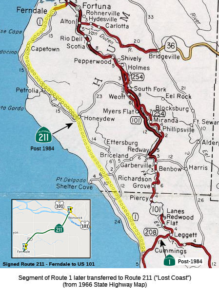
 In 1984, Chapter 409 redefined the route as "Route 1 near
Rockport to Route 101 near Fernbridge". This was the result of a diversion
of Route 1 was diverted to terminate at US 101; this was an unconstructed
segment of Route 1 (SB 2471, Chapter 409). It is unconstructed from Route 1 to Ferndale. Traversable local roads between the US 101 and the
Mendocino County Line include Chemise Mountain Road, Kings Peak Road,
Wilder Ridge Road, and Mattole Road. These roads are not constructed to
state highway standards and are unacceptable candidate highways for the
state highway system. Between the Mendocino County Line and Route 1, the
existing road is primitive and unsuitable for use as a state highway.
In 1984, Chapter 409 redefined the route as "Route 1 near
Rockport to Route 101 near Fernbridge". This was the result of a diversion
of Route 1 was diverted to terminate at US 101; this was an unconstructed
segment of Route 1 (SB 2471, Chapter 409). It is unconstructed from Route 1 to Ferndale. Traversable local roads between the US 101 and the
Mendocino County Line include Chemise Mountain Road, Kings Peak Road,
Wilder Ridge Road, and Mattole Road. These roads are not constructed to
state highway standards and are unacceptable candidate highways for the
state highway system. Between the Mendocino County Line and Route 1, the
existing road is primitive and unsuitable for use as a state highway.
Will the "Lost Coast" highway ever be constructed? The consensus is that
it is unlikely. Tom Fearer noted on AARoads that the terrain is far from
conducive for building anything but a road that hugs the terrain.
The Lost Coast would require massive excavation of mountains that are at
times thousands of feet high. The terrain of Santa Lucia Range is
essentially compacted mud which is why both regions are so slide prone,
especially during rainy winters. Scott Parker added that when the Lost
Coast extension of Route 1 was projected back in 1959 (now Route 211),
much of the impetus from that came from logging interests looking for a
more efficient way of hauling redwood out to the mills along US 101.
As the construction needs for redwood have long passed, and most of the
mills are out of operation, there is little call and even less need for
such a road. Occasionally there have been proposals for a southward
extension of Route 211 from Ferndale (principally as a recreational
route), following forest roads and eventually cutting back to US 101 near
Garberville. He agreed with Tom's description of the area as a huge
mudpatch (resulting in extensive road closures during rainy periods), and
that the cost of grading and ballasting would be out of line for the
likely traffic levels for such a highway. The final nail in the
coffin is the chances of satisfying current environmental requirements
plus the requirements of the Coastal Commission.
(Source: AARoads Discussion: "Re: Highway 1 through the lost coast", 1/20/2019)
 Pre 1964 Signage History
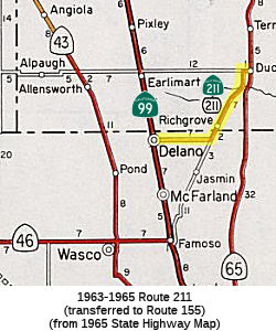 The 1963-1965 definition of Route 211 between Delano and
the Famoso-Porterville Highways was part of LRN 136, defined in 1933. This
portion is now Route 155 (which continues to the E to meet the former LRN 142 portion of Route 155). The portion along the Famoso-Porterville
highway and Richgrove Drive was LRN 129, also defined in 1933. This was
once Route 65. The Richgrove Drive portion is now County Sign Route J35.
The 1963-1965 definition of Route 211 between Delano and
the Famoso-Porterville Highways was part of LRN 136, defined in 1933. This
portion is now Route 155 (which continues to the E to meet the former LRN 142 portion of Route 155). The portion along the Famoso-Porterville
highway and Richgrove Drive was LRN 129, also defined in 1933. This was
once Route 65. The Richgrove Drive portion is now County Sign Route J35.
The post-1984 routing was originally part of LRN 56, and was to have been signed as part of Route 1.
LRN 56 (Sign Route 1, eventual Route 211) was extended north to Ferndale
to LRN 1 (US 101) in 1933. Prior to 1933 the legislative description
of LRN 56 had it's north terminus in Carmel and south terminus in San Luis
Obispo. Tom Fearer notes that close examination of the map displayed in
the August 1934 CHPW shows Route 1/LRN 56 as a functionally existing
highway from Westport north to Fortuna. He also notes that the 1934
Division of Highways State Map shows State maintenance of Route 1/LRN 56
from Mendocino north to Fort Bragg. It also shows from Fort Bragg
northward the implied route to Upper Mattole, and from Upper Mattole the
implied through highway through the Lost Coast to Ferndale. Tom also
examined the 1935 Goshua Highway Map of California, which shows Route 1/LRN 56 ending at Westport and the road continuing north to Kenny on Usal
Road. From Kenny the highway to Thorn Junction appears to have
followed Briceland Road to Thorn Junction. From Thorn Junction to
Ettersburg the highway follows Ettersburg Road. From Ettersburg to
Honey Dew the through highway follows Wilder Ridge Road. From Honey
Dew the through route in the Lost Coast follows Mattole Road to Ferndale
and the north segment of Route 1/LRN 56. The 1935 Goshua Map doesn't
offer any evidence that Route 1 was signed by the California State
Automobile Association in the Lost Coast. Tom notes that the first
Division of Highways Map to display a rough planned general alignment of
Route 1/LRN 56 in the Lost Coast was the 1953 edition.
(Source: Tom Fearer, Gribblenation Blog, "Paper Highways; California State Route 1 through the Lost Coast")
In 1956, a spur of LRN 56 was added to connect Route 1 to US 101 at
Leggett. Per the May/June 1958 CHPW, the Westport-Leggett spur of LRN 56
was ultimately signed as part of Route 1 and was part of Federal Aid
Secondary Rte 504. Mendocino County is said to have pushed during
the fall of 1955 to have the planned Westport-Leggett Spur of LRN 56
added. The article goes onto cite that part of the 1951 legislation
that added the Westport-Leggett Spur of LRN 56 was that the State would
not have to maintain the roadway until it was brought up to Division of
Highways standards. Maintenance of the Westport-Leggett Spur of LRN 56 began on July 1, 1957.
(Source: Tom Fearer, Gribblenation Blog, "Paper Highways; California State Route 1 through the Lost Coast")
In the 1964 Renumbering, the spur to Leggett was renumbered to Route 208 (although it was not signed as such). In 1984, Route 208 was officially transferred to Route 1, and the "lost coast" was transferred to Route 211.
Fernbridge (HUM 78.586)
Approaching the end of the 19th century, residents of
Ferndale and greater Eel River Valley petitioned for a bridge to be
constructed at the Eel River. The destruction from the 1906 San Francisco
Earthquake necessitated any bridge located at the Eel River to be
constructed of reinforced concrete. On November 8, 1909, the
Humboldt County Surveyor submitted a report suggesting the location of
Singley's Bend as a recommended site for an Eel River Bridge.
Humboldt County accepted bids by Pacific Construction to build the
Fernbridge during 1910 and construction broke ground on March 20, 1910 at
Singley's Bend. The concrete arch construction of the Fernbridge was
designed by engineer John B. Leonard. The Fernbridge was completed on
November 8, 1911 and opened to traffic on November 16. The
Fernbridge (Eel River Bridge) had a a total distance of 2,501 feet and was
at the time the longest arch concrete span in the world. The central
arch concrete structure of the Fernbridge was 1,451 feet with the balance
of the structure's remaining length comprised of wooden approach
spans. The Fernbridge road deck at that time was 24 feet wide.
Construction of the Fernbridge cost $245,967. The Fernbridge was
subjected to flooding along the Eel River during 1912, 1913, 1914 and
1915. During 1920 the wooden approach spans to the Fernbridge were
replaced with concrete ramps.
(Source: Gribblenation Blog (Tom Fearer), "The indomitable Fernbridge (California State Route 211)", 12/2022)
During 1933, LRN 56 was extended south to LRN 2 (US 101) near Las Cruces (from an original terminus in San Luis Obispo) and
north to Fortuna to LRN 1 (also US 101) (from an original terminus in
Carmel) via the Fernbridge. This added the Fernbridge to the State
Highway System. In 1961, a freeway routing for Route 1/LRN 56 from Van
Ness Avenue in Ferndale to the western approach to the Fernbridge was
selected. This corridor was ultimately constructed as a two-lane
expressway that terminated at the western approach of the Fernbridge in
the following years.
(Source: Gribblenation Blog (Tom Fearer), "The indomitable Fernbridge (California State Route 211)", 12/2022)
Flooding at the end of 1955 damaged the concrete
western approach to the Fernbridge; this was repaired in 1956. There was
also flooding during the Christmas Floods of December 1964. The
Fernbridge notably was one of the only structures along the Eel River to
have survived those flood with minimal damage, and the Fernbridge in
conjunction with Blue Slide Road was pressed into duty as the temporary
alignment of US 101. On September 24, 1976, the American Society of
Engineering designated the Fernbridge as a significant civil engineering
landmark. Following the floods of 1986, Caltrans District I recommended
conducting a study to remove the Fernbridge (part of the renumbered Route 211 since 1984) in favor of a modern span, but there was resistance from
Eel River Valley community members the removal or replacement of the
Fernbridge. By April 1987, the Fernbridge was added to the National
Register of Historic Places. Caltrans would ultimately opt not to
remove the Fernbridge after it was added to the National Register of
Historic Places. During August 1990 the Fernbridge was given a Poor
Sufficiency rating of 10.8. On April 25-26, 1992, the Cape Mendocino
Earthquakes shook the North Coast and Eel River Valley regions. The
first 7.2 magnitude earthquake occurred at 11:06 AM on April 25th and was
centered three miles east of Petrolia. Two 6.5 magnitude aftershocks
occurred on April 26th and centered west of Petrolia. Despite the
nearby shaking and Poor Sufficiency rating of the Fernbridge the structure
survived. In the years after the Cape Mendocino Earthquakes the
Fernbridge was renovated. During 1998 the Fernbridge received a
Sufficiency Rating of 33.0. On December 20, 2022, the 6.4 magnitude
Ferndale Earthquake structure just offshore west of Ferndale at 2:34
AM. The Fernbridge was closed for a day while temporary repairs were
made.
(Source: Gribblenation Blog (Tom Fearer), "The indomitable Fernbridge (California State Route 211)", 12/2022)
 Status
The current routing is unconstructed from Route 1 to Ferndale and is not signed. The portion of the route between the Ferndale city limits and US 101 is signed. The traversable route in Mendocino County is Chemise Mountain Road, Wilder Ridge Road, and Mattole Road.
The 2013 Traversable Highways report notes that the segment from Mendocino County Line to Ferndale (73.2 mi) consists of Chemise Mountain Road, Kings Peak Road, Wilder Ridge Road, Mattole Road - These roads are not constructed to State standards. These roads are unacceptable candidate highways for the state highway system at this time. For the segment from Route 1 to Humboldt County Line (29.6 mi), the closest is Usal Road - Existing road is primitive and unsuitable for use as a state highway.
The Historic Fernbridge (01-Hum-211 R77.2/78.6)
In March 2023, the CTC was informed about the following
Emergency G-11 Allocation under Caltrans delegated authority: $7,800,000.
01-Hum-211 R77.2/78.6. PPNO 01-2598; ProjID 0123000063; EA 0M730.
Emergency. Route 211 Near Ferndale, at Eel River Bridge № 04-0134.
On December 20, 2022, an earthquake occurred near Ferndale caused
significant damage to the Eel River Bridge. The bridge was closed to
traffic. The damage assessments indicate structural damage to the
bridge at multiple piers, columns, girders, and bents. This project
will repair the bridge, replace bridge railing, and place erosion control.
CON ENG $1,800,000; CONST $6,000,000.
(Source: March 2023 CTC Agenda, Agenda Item 2.5f.(1) #3)
In March 2023, the CTC amended into the 2022 SHOPP the
following repair to the historic Fernbridge after significant earthquakes
in the area: 01-Hum-211 R77.2/78.6. PPNO 01-2598; ProjID 0123000063; EA
0M730. On Route 211 Near Ferndale, at Eel River Bridge № 04-0134.
Repair bridge, replace bridge railing, and place erosion control. Note: On
December 20, 2022, an earthquake occurred near Ferndale caused significant
damage to the Eel River Bridge. The bridge was closed to
traffic. The damage assessments indicate structural damage to the
bridge at multiple piers, columns, girders, and bents. This project
will repair the bridge, replace bridge railing, and place erosion control.
Allocation ($ × 1,000): PA&ED $0; PS&E $0; R/W Sup $50; Con
Sup $1,800; R/W Cap $50; Const Cap $6,000; TOTAL $7,900. FY22-23.
(Source: March 2023 CTC Agenda, Agenda Item 2.1a.(1a) #2)
 Naming
Route 1 and Route 211 from Mill Valley (Marin County) to Ferndale (Humboldt County) are named the "Shoreline Highway". The portion of the route between Rockport and Ferndale (Route 211) is not constructed. The road runs along the Pacific Shore. Named by Senate Concurrent Resolution 91, Chapter 239 in 1957.
This portion of coastline is sometimes referred to as "The Lost Coast"
 Other WWW Links
 Statistics
Overall statistics for Route 211:
 Pre-1964 Legislative Route
This route number appears not to have been assigned by the California Legislature before the 1963 renumbering.
© 1996-2020 Daniel P. Faigin.
Maintained by: Daniel P. Faigin
<webmaster@cahighways.org>.
 FromRoute
  Route 210
 Route 212