
 California Highways:
Click here for a key to the symbols used. An explanation of acronyms may be found at the bottom of the page.
 Routing
 Post 1964 Signage History
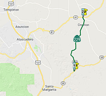
In 1963, Route 229 was defined as the route “Route 58 near Santa Margarita to Route 41 near Creston”.
Originally Route 229 terminated at Route 41 at the Huerhuero Creek
Bridge. Following the 1995 floods on the Salinas River, Route 41
underwent improvements between Atascadero and Creston. This resulted
in a new Huerhuero Creek Bridge being built north of Creston which by
proxy extended Route 229 a short distance.
(Source: Gribblenation Blog (Tom Fearer), “California State Route 229”, May 2021)
 Pre 1964 Signage History
This route was LRN 137, defined in 1933. It was unsigned before 1964. The portion from Creston to 3 mi S of Creston was part of US 466 in 1937, and would have been part of LRN 125.
Tom Fearer, in the referenced Gribblenation Blog, notes:
(Source: Gribblenation Blog (Tom Fearer), “California State Route 229”, May 2021)
Route 229 is notable due to having a 6 mile long one-lane section and one of the lowest traffic counts in the State Highway System. The northern 3 miles of Route 229 from Rocky Canyon Road to Route 41 is largely aligned over what was US 466. The entirety of Route 229 is signed on Webster Road.
The March/April 1962 California Highways & Public Works notes LRN 125/Rocky Canyon Road had been given to San Luis Obipso County via a
maintenance swap in exchange for Creston-Eureka Road. This measure
added Creston-Eureka Road to LRN 125 and extended LRN 137 from Rocky
Canyon Road north through Creston.
(Source: Gribblenation Blog (Tom Fearer), “California State Route 229”, May 2021)
 Status
This route is signed between Route 58 and Route 41. It is supposedly still signed (as of 2004) at the junction with Route 58. The road itself (Webster Rd) is only one lane wide from Route 58 north to a mile southwest of Rocky Creek Road, at which point it becomes a two-lane route all the way through Creston and to its terminus at Route 41. (On Route 41, there are signs pointing to Route 229 at that junction as well). The route itself doesn't seem to have any trailblazers but does have mileposts (a similar situation to Route 221 in Napa, which is signed at the junctions but not on the route itself).
 Other WWW Links
 Statistics
Overall statistics for former Route 229:
 Pre-1964 Legislative Route
In 1947 (1st Ex Sess), Chapter 11 defined LRN 229 as “a connection between [LRN 68] and [LRN 2] near San Bruno”.
In 1959, Chapter 1062 swapped the ends and extended the route to [LRN 56]: “[LRN 56] near Pacifica to [LRN 68] near San Bruno”
This is present-day I-380.
© 1996-2020 Daniel P. Faigin.
Maintained by: Daniel P. Faigin
<webmaster@cahighways.org>.
 Route
Route  Route 228
 Route 230