
 California Highways:
Click here for a key to the symbols used. An explanation of acronyms may be found at the bottom of the page.
 Routing
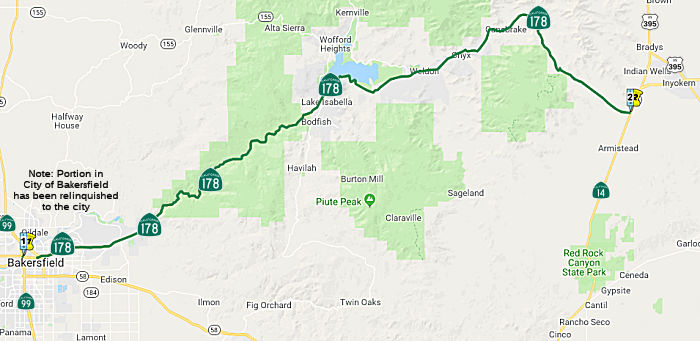 From Bakersfield to Route 14 near Freeman via Walker Pass.
In 2006, AB 1858 (Chapter 315, September 18, 2006) authorized relinquishment in Bakersfield:
Upon a determination by the commission that it is in the best interests of the state to do so, the commission may, upon terms and conditions approved by it, relinquish to the City of Bakersfield the portion of Route 178 that is located within the city limits of that city if the city agrees to accept it. The following conditions shall apply upon relinquishment: (1) The relinquishment shall become effective on the date following the county recorder's recordation of the relinquishment resolution containing the commission's approval of the terms and conditions of the relinquishment. (2) On and after the effective date of the relinquishment, the relinquished portion of Route 178 shall cease to be a state highway. (3) The portion of Route 178 relinquished under this subdivision shall be ineligible for future adoption under Section 81. (4) For the portion of Route 178 that is relinquished under this subdivision, the City of Bakersfield shall install and maintain within its jurisdiction signs directing motorists to the continuation of Route 178.
The portion in Bakersfield was relinquished in June 2011.
In 2012, AB 2679 (Chapter 769, 9/29/2012) updated the language to reflect the relinquishment:
(b) Upon a determination by the commission that it is in the best interests of the state to do so, the commission may, upon terms and conditions approved by it, relinquish to the City of Bakersfield the portion of Route 178 that is located within the city limits of that city if the city agrees to accept it. The following conditions shall apply upon relinquishment:
(1) The relinquishment shall become effective on the date following the county recorder’s recordation of the relinquishment resolution containing the commission’s approval of the terms and conditions of the relinquishment.
(2) On and after the effective date of the relinquishment, the relinquished portion of Route 178 shall cease to be a state highway.
(3) The portion of Route 178 relinquished under this subdivision shall be ineligible for future adoption under Section 81.
(4)(b)For theThe relinquished former portion of Route 178that is relinquished under this subdivision,within the City of Bakersfield is not a state highway and is not eligible for adoption under Section 81. For the relinquished former portion of Route 178, the City of Bakersfield shall install and maintain within its jurisdiction signs directing motorists to the continuation of Route178.178 and shall ensure the continuity of traffic flow on the relinquished portion of Route 178, including any traffic signal progression.
 Post 1964 Signage History
As defined in 1963, this segment had the route: “(a) Route 99 in Bakersfield to Route 14 near Freeman via Walker Pass.” Later that year, Chapter 1698 relaxed the definition to be “(a) Bakersfield to Route 14 near Freeman via Walker Pass.”
 Pre 1964 Signage History
Original Route 178 between Santa Margarita and Bakersfield (now Route 58)
In 1934, Route 178 was signed along the route from Jct. US 101 at Santa Margarita to Jct. Route 7 (US 395) at Freeman Junction via Bakersfield. The route originally began at US 101 near Santa Margarita, and continued through Pozo, La Panza and McKittrick. It then ran through Buttonwillow, and Rosedale to Bakersfield. This was LRN 58, defined in 1919, and is present-day Route 58. In the 1964 renumbering, the portion from US 101 to Route 99 was transferred to Route 58.
Tom Fearer (Max Rockatansky) noted on AARoads:
(Source: Tom Fearer on AARoads, "Bitterwater Road, Old SSR 178, more LRN 137, and the 1914 Salinas River Bridge", 2/8/2017)
From 1934 to 1956, Route 178 would have used Pozo Road to cross the La Panza Range to reach Santa Margarita and US 101. A look at even Google Maps shows why Route 178 was realigned, it wasn't a very good route that had a hugely twisty alignment. The modern route is largely something you can hold a decent 45-55 MPH in most curves much like Route 198 over the Diablos. When Route 178 was plotted out in 1934 it went through a town called La Panza (named after the range) and the village of Pozo which is located near Santa Margarita Lake. Pozo still exists as an inhabited place while La Panza is now a ghost town. Splitting off of Route 58 on Pozo Road there was oddly a Calfire Station despite the poor road quality. On the old California state maps, LRN 137 runs from Route 178 just outside of Santa Margarita over the Salinas River up to Creston. In 1956, Route 178/LRN 58 was realigned along what was LRN 137 to the modern southern terminus of Route 229 east along modern Route 58. US 101 was also shifted west to the modern bypass which meant Route 178/LRN 58 was extended through Santa Margarita.
The first segment of future Sign Route 178 was completed in 1925. The
Kern River Highway, as it was known then, ran from Bakersfield to Democrat
Hot Spring. Kern County did the initial construction of the route.
(Source: LA Times, 12/22/1925, via Joel Windmiller, 1/27/2023)
Freeway from Downtown Bakersfield to approximately 4 miles out of town. Freeway ends for 1 mile, and then begins again (signed as freeway as a 2 lane road section for 2.2 miles). Also begins again near the town of Lake Isabella. Originally in Bakersfield, Route 178 followed 24th Street, had a short multiplex with southbound US 99/eastbound US 466 on Golden Stave Avenue (present day Route 204/Business Route 99), and a short multiplex with US 466 (Sumner Street) to Baker Street. It then continued north on Baker Street and then east on Niles Street. The traffic circle underneath the current Route 204/Business Route 99 freeway at Chester Avenue was in existence even in 1942, when Route 204/Business Route 99 was US 99/US 466.
 In 1966, it was reported that a route had been adopted
from Bakersfield to Lake Isabella. Construction was expected to start in
1972, with the entire project costing around $53 million. The map to the
right, from the Bakersfield Californian, has been highlighted to show both
existing and proposed routes.
In 1966, it was reported that a route had been adopted
from Bakersfield to Lake Isabella. Construction was expected to start in
1972, with the entire project costing around $53 million. The map to the
right, from the Bakersfield Californian, has been highlighted to show both
existing and proposed routes.
(Source: Bakersfield Californian, 3/23/1966 via Joel Windmiller,
1/29/2023)
The complete freeway version of the route did not get built because the funding was cut off in 1974 when Governor Jerry Brown ended the freeway building binge. Proposed Freeway 178 is part of the both the County and the City of Bakersfield's 2010 General Plan. The route adoption was made April 27, 1960 by the California Highway Commission. The proposed freeway would follow existing alignment as a far Mesa Marin Raceway. The state already owns this piece, it pretty clearly marked by a fence line on either side of Route 178. Then the Route 178 Freeway breaks north and crosses the Kern River east of the county golf course. It would then follow Rancheria Rd more or less for about 10 miles until it drops south through a tunnel into the existing freeway segment at the top of the canyon.
The route then ran along the current routing through Bodfish, Weldon, the Sequoia Forest, and Freeman. The routing ended at Route 7 (now Route 14/US 395). This was LRN 57, defined in 1919.
 In 1956, the CHC adopted two reroutings for Route 178,
between 3 mi W of Weldon (~ KER 54) and Weldon, and between 4 mi E of
Weldon and 1.3 mi E of Walker Pass (~ KER 83.759). The section between
these two segments was adopted in 1952. The 1956 highway followed an old
routing and had many curves and sharp dips subject to flooding. The new
routing provided for relocation of some portions and elimination of sharp
curves and loops on other locations. The plan was to construct a two-lane
highway at a cost of $1.8 million, including right of way. However,
by the looks of the 2023 routing, especially E of Onyx, these new routings
were never constructed.
In 1956, the CHC adopted two reroutings for Route 178,
between 3 mi W of Weldon (~ KER 54) and Weldon, and between 4 mi E of
Weldon and 1.3 mi E of Walker Pass (~ KER 83.759). The section between
these two segments was adopted in 1952. The 1956 highway followed an old
routing and had many curves and sharp dips subject to flooding. The new
routing provided for relocation of some portions and elimination of sharp
curves and loops on other locations. The plan was to construct a two-lane
highway at a cost of $1.8 million, including right of way. However,
by the looks of the 2023 routing, especially E of Onyx, these new routings
were never constructed.
(Source: Bakersfield Californian, 8/23/1956 via Joel Windmiller,
1/29/2023)
Michael Ballard has a page presenting Russ Connelly's historical exploration of the development and early routings of Route 178. The
page provides a historical tour of Route 178, It provides the full history
of the route for the segment between Kern Canyon and Freeman Junction
(i.e., working W from the jct. with Route 14). I'd bring some of the text
over here to summarize just the highway history, but Michael is
particularly sensitive about things like that, so please go take a look at
Russ's exploration. It is well worth your time. But the following are some
key bullet points:
(Reference: Historical Tour of State Highway 178, Russ Connelly)
 Status
Bakersfield Crosstown Freeway
The SAFETEA-LU act, enacted in August 2005 as the reauthorization of TEA-21, provided the following expenditures on or near this route:
This route is not yet formally in the state highway system. The proposed freeway is supposed to start about ¾ mile from where Route 178 comes to an end in Downtown Bakersfield. From there, it will curve south, then west to run along the railroad tracks south of the existing Route 178. The freeway would then begin to curve slightly north, then west as it crosses over Route 99. Then it will run about 5 miles west where it will join up with the future Westside Beltway.
The Centennial Corridor is an 8 lane freeway that will connect the Westside Parkway west of Route 99 to State Route 178 in the northeast part of Bakersfield. The project study report (PSR), a preliminary planning document, is currently underway for this project. The environmental document and initial engineering/alignment studies for the Centennial Corridor are planned to begin the Summer of 2003 and will take several years to complete. Currently, the initial phase of construction for the Centennial Corridor is planned for 2008 or 2009. The Centennial Corridor will connect to the Westside Parkway and is currently planned to continue east under Route 99 and under Oak Street north of the BN&SF railroad tracks. There is proposed to be a SPUI interchange at Oak Street. In the downtown area, the Centennial Corridor is proposed to go over and have a partial interchange with F Street. Continuing east after F Street, the Centennial Corridor is then planned to swing south over the BN&SF railroad tracks. There would be an off ramp to 14th Street which would allow access to areas north and south of the Centennial Corridor at Chester Avenue, L Street, N Street, and Q Street. At Q Street, there is proposed to be an on ramp for eastbound traffic and an off ramp for westbound traffic.
More information on the Centennial Corridor will be found with Route 58.
The SAFETEA-LU act, enacted in August 2005 as the reauthorization of TEA-21, provided the following expenditures on or near this route:
In June 2011, the CTC authorized relinquishment of right of way in the city of Bakersfield on Route 178 from Route 99 to M Street (~ KER 0.142 to KER 0.162), under terms and conditions as stated in the relinquishment agreement dated May 2, 2011, determined to be in the best interest of the State. Authorized by Chapter 315, Statutes of 2006, which amended Section 478 of the Streets and Highways Code.
In May 2014, the CTC approved for future consideration of funding a project in Kern County that will correct the seismic deficiencies of four bridges on Route 99 and Route 178 in Kern County, including the Airport Drive Overcrossing (Bridge Number 50- 0266) and the Golden State Avenue Separation (Bridge Numbers 50-0326 Right, 50-0326 Left, and 50-0326 Center., 178 KER R001.95). The project is programmed in the 2014 State Highway Operation and Protection Program. The total estimated cost is $10,139,000 for capital and support. Construction is estimated to begin in Fiscal Year 2016-17.
![[178 Fairfax I/C]](maps/178-fairfax.jpg) Caltrans has plans to construct an interchange at Route 178 and Fairfax Road (~ KER R6.782). The construction will include
soundwalls and the widening of Route 178 from a two-lane expressway to a
four- lane freeway, east of Oswell Street overcrossing to west of Morning
Drive. Construction should start in September 2007, and be completed by
September 2009.
Caltrans has plans to construct an interchange at Route 178 and Fairfax Road (~ KER R6.782). The construction will include
soundwalls and the widening of Route 178 from a two-lane expressway to a
four- lane freeway, east of Oswell Street overcrossing to west of Morning
Drive. Construction should start in September 2007, and be completed by
September 2009.
In April 2017, an update was provided on Route 178 improvements in
Bakersfield. These improvements widen the highway from two to six lanes
from just east of Morning Drive to Masterson Street and from two to four
lanes from Masterson to Miramonte Drive (~ KER R7.741 to KER 10.195).
Masterson, Alfred Harrell Highway, Miramonte and Route 184 will be
realigned and/or widened where they intersect with Route 178. The
improvements are 85 percent complete, with completion expected in May
2017. The old Route 178/Route 184 intersection is closed so the contractor
can complete work in this area. This closure is expected last until
mid-May 2017. The contractor completed the final lift of paving on Route 178 and Route 184 in March. The contractor plans to pave the section of
Route 178 between Masterson Street and Alfred Harrell Highway with
rubberized asphalt, which is generally used to reduce road noise, in
April.
(Source: Bakersfield.Com, 4/20/2017)
According to Caltrans, there is an unconstructed adopted route from W of Route 184 to W of Miracle Hot Springs that is parallel to the existing route. (~ KER T9.639)
Canyon Section of Route 178
The canyon segment of Route 178 scores a unheard of 257 on the state's safety index; this means that the canyon portion of Route 178 gets 257% more accidents then would be expected on a mythical state highway with similar average daily traffic. Current thought is that having the highway in the canyon next to the Kern River (a) poses a significant threat to the riparian ecosystem in the Kern Canyon, (b) a risk to the water quality of ground the water recharge supply in the southern San Joaquin valley, (c) a risk to the drinking water supply of metropolitan Bakersfield, and (d) a risk to the irrigation water supply to the farms in the southern San Joaquin Valley. [Information on the history of Route 178 comes from a post by Karl Davisson]
The risk of the canyon section of Route 178 was
highlighted again in 2013. In 2012, CHP said it handled 48 accidents in
the canyon. As of April 2013, there have been 18 accidents in the area.
According to officials these accidents are not only costing lives, but
also taxpayer money. A recent rescue on the route cost at least $34,000.
Currently there are guardrails installed sporadically along Route 178 in
the canyon. When Caltrans was asked whether additional guardrails could be
installed, the response was that many locations in the canyon only have
one or two feet of shoulder, and Caltrans needs more than that to properly
and safely install guardrailing. The posts supporting the rails need to
have sufficient rigidity and integrity to withstand an out of control
vehicle. Concrete walls in steep canyon areas are not feasible, but due to
cost and environmental impacts.
(Source: ABC23, 4/23/13)
 Naming
Kern Canyon Road to Route 155; Walker Pass Road to Route 14. Kern River was named by Frémont in 1845, for his topographer and artist, Edward M. Kern of Philadelphia. The county was named in 1866.
 The portion of Route 178 between M Street and Fairfax Road in the City of Bakersfield (~
KER 0.18 to KER R6.792) in Kern County is named the "CHP Officer David
W. Manning Memorial Freeway." It was named in honor of California
Highway Patrol Officer David W. Manning, who passed away on February 15,
1996, from injuries he received on January 26, 1996 as a result of a
traffic accident. Officer Manning had been one of the first officers
assigned to the new Bakersfield area motor squad when it was reactivated
after a 25-year absence. He liked to carry candy canes with him while on
duty to hand out to children he encountered. At the scene of his fatal
collision, Officer Manning's motorcycle was on its side surrounded by
candy canes. He was a member of the California Highway Patrol for eight
years and served in East Los Angeles and Bakersfield. Named by Senate
Concurrent Resolution 50, July 16, 2004, Chapter 117.
The portion of Route 178 between M Street and Fairfax Road in the City of Bakersfield (~
KER 0.18 to KER R6.792) in Kern County is named the "CHP Officer David
W. Manning Memorial Freeway." It was named in honor of California
Highway Patrol Officer David W. Manning, who passed away on February 15,
1996, from injuries he received on January 26, 1996 as a result of a
traffic accident. Officer Manning had been one of the first officers
assigned to the new Bakersfield area motor squad when it was reactivated
after a 25-year absence. He liked to carry candy canes with him while on
duty to hand out to children he encountered. At the scene of his fatal
collision, Officer Manning's motorcycle was on its side surrounded by
candy canes. He was a member of the California Highway Patrol for eight
years and served in East Los Angeles and Bakersfield. Named by Senate
Concurrent Resolution 50, July 16, 2004, Chapter 117.
(Image Source: AARoads; California Assn of Highway Patrolmen)
 Hudnall, Jr., Memorial Highway") The portion of Route 178 from PM KER 13.7 at the
mouth of Kern Canyon eastbound to its intersection with Kernville Road
(Route 155) (~ KER 13.7 to KER R42.948) in Kern County is named the "Kern
County Deputy Sheriff William "Joe" Hudnall, Jr., Memorial Highway".
This segment was named in memory of Deputy Sheriff William "Joe" Hudnall
Jr., who was hired by the Kern County Sheriff's Department on September
27, 1997, after putting himself through the P.O.S.T. Academy at his own
expense. Deputy Sheriff Hudnall was killed in the line of duty on November
14, 2006, while transporting a prisoner from his duty assignment in
Kernville, California, to Bakersfield, California. His patrol unit was
struck head-on, on Route 178 in Kern Canyon, by a vehicle operated by a
person who was under the influence of a controlled substance. Named by
Assembly Concurrent Resolution (ACR) 90, Resolution Chapter 71, on
7/3/2008.
The portion of Route 178 from PM KER 13.7 at the
mouth of Kern Canyon eastbound to its intersection with Kernville Road
(Route 155) (~ KER 13.7 to KER R42.948) in Kern County is named the "Kern
County Deputy Sheriff William "Joe" Hudnall, Jr., Memorial Highway".
This segment was named in memory of Deputy Sheriff William "Joe" Hudnall
Jr., who was hired by the Kern County Sheriff's Department on September
27, 1997, after putting himself through the P.O.S.T. Academy at his own
expense. Deputy Sheriff Hudnall was killed in the line of duty on November
14, 2006, while transporting a prisoner from his duty assignment in
Kernville, California, to Bakersfield, California. His patrol unit was
struck head-on, on Route 178 in Kern Canyon, by a vehicle operated by a
person who was under the influence of a controlled substance. Named by
Assembly Concurrent Resolution (ACR) 90, Resolution Chapter 71, on
7/3/2008.
(Image source: Facebook; Find a Grave)
 Freeway
[SHC 253.7] Entire portion. Added to the Freeway and Expressway system in 1959.
 From Route 14 near Freeman to Route 127.
Post 1964 Signage History Pre 1964 Signage HistoryThis was not part of the original 1934 signage of Route 178. This was LRN 212, defined in 1947. It was not signed until after 1964.
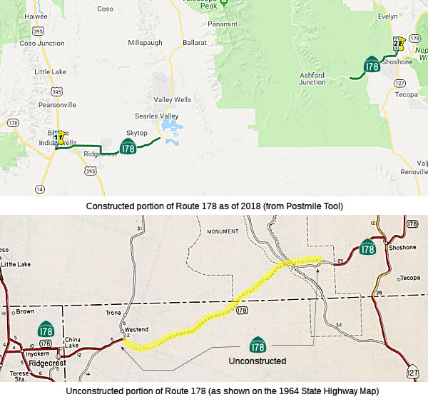
StatusUnconstructed Portion
 This segment is unconstructed from 15 miles east of Ridgecrest to 15 miles west of Route 127 (10 miles from the
eastern boundary of the Death Valley National Monument). The "traversable"
route is a winding dirt road through mountain passes in a desolate area.
It passes through the gunnery range of the China Lake Naval Weapons Center
and through the Wingate Wash area (a National Park Service designated
wilderness area). The area is not suitable for a state highway, and
District 9 recommends it be deleted from the state highway system.
This segment is unconstructed from 15 miles east of Ridgecrest to 15 miles west of Route 127 (10 miles from the
eastern boundary of the Death Valley National Monument). The "traversable"
route is a winding dirt road through mountain passes in a desolate area.
It passes through the gunnery range of the China Lake Naval Weapons Center
and through the Wingate Wash area (a National Park Service designated
wilderness area). The area is not suitable for a state highway, and
District 9 recommends it be deleted from the state highway system.
The 2013 Traversable Highways report notes this is a winding dirt road through mountain passes in a desolate area. This portion of Route 178 passes through a gunnery range of the China Lake Naval Weapons Center and through the Wingate Wash area. A portion of the Wingate Wash has been designated a wilderness area by the National Park Service. No traversable highway is present and the area is not suitable for a state highway. The Legislative route description should be changed to match the constructed SHS portion.
In January 2020, the CTC allocated $416,000 for a SHOPP project at
09-Ker-178 PM 92.5/92.6. Route 178 in Kern County, near Inyokern at Brown
Road. Outcome/Output: Widen shoulders and provide pedestrian
access on both sides of the roadway. EA 37790. ProjID 0918000053.
(Source: January 2020 CTC Agenda, Agenda Item 2.5a)
Trona Earthquake Damage
In October 2019, the CTC amended the following into the
2018 SHOPP: 08-SBd-178 5.5/R12.0. PPNO 3015V. Proj ID 0820000004. EA
1L260. Route 178 Near Ridgecrest, from 2.4 miles west of Trona Road to 1.1
miles east of Salt Wells Canyon. Repair earthquake damaged roadway. Total
Cost: $4,380K. This was to repair damage from the Trona Earthquakes in
July 2019: a 6.4 magnitude punch on the Fourth of July, then a giant 7.1
magnitude a week later, with many large aftershocks in between. The CTC
also approved the following emergency allocation: 08-SBd-178 5.5/R12.0.
PPNO 3015V Proj ID 0820000004 EA 1L260. On Route 178 Near Ridgecrest, from
2.4 miles west of Trona Road to 1.1 miles east of Salt Wells Canyon. On
July 4 and 5, 2019, two earthquakes 6.4 and 7.1 respectively, caused
damaged to Route 178 at various locations near Ridgecrest and Trona. The
earthquakes caused cracking, deformation, buckling of pavement, and slope
failure. This project will provide temporary traffic control, excavate and
backfill failed roadway, stabilize slopes, and remove and repair damaged
pavement. $3,850,000
(Source: October 2019 CTC Agenda, Agenda Item
2.2a.(1); Agenda Item 2.5f.(1) #22)
Naming"Inyokern" Road; "Trona" Road
Freeway[SHC 253.7] From Route 14 near Freeman to the vicinity of the San Bernardino county line. Added to the Freeway and Expressway system in 1959.
 Scenic Route
[SHC 263.7] From the east boundary of Death Valley National Monument to Route 127 near Shoshone.
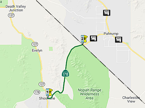 From Route 127 to the Nevada state line in Pahrump Valley.
Post 1964 Signage HistoryThis segment remains as defined in 1963: “(c) Route 127 to the Nevada state line in Pahrump Valley.”
Pre 1964 Signage HistoryThis was not part of the original 1934 signage of Route 178. This was LRN 212, defined in 1947. It was not signed until after 1964.
Naming This segment is named the "Charles Brown Highway". It was named by Senate Concurrent Resolution 13, Chapter
244, in 1961. California State Senator Charles Brown served the people of
Inyo and Mono Counties from 1939 to 1962. Charles Brown commenced his
career of public service as a Deputy Sheriff in Inyo County, and then as a
member of the Inyo County Board of Supervisors, an office he held for 14
years before his first election to the Legislature in 1938. As
representative for almost a quarter of a century of the 28th Senatorial
District comprised of Alpine, Inyo, and Mono Counties, he was a familiar
sight in the State Capitol -- a tall erect stern featured but kind man
well liked by both colleagues and constituents. During his 24 year term in
the State Legislature, Charles Brown served with distinction on many
Senate committees including the Committees on Fish and Game, Natural
Resources, Governmental Efficiency, and Finance; he was also a member for
20 years of the Senate Rules Committee.
This segment is named the "Charles Brown Highway". It was named by Senate Concurrent Resolution 13, Chapter
244, in 1961. California State Senator Charles Brown served the people of
Inyo and Mono Counties from 1939 to 1962. Charles Brown commenced his
career of public service as a Deputy Sheriff in Inyo County, and then as a
member of the Inyo County Board of Supervisors, an office he held for 14
years before his first election to the Legislature in 1938. As
representative for almost a quarter of a century of the 28th Senatorial
District comprised of Alpine, Inyo, and Mono Counties, he was a familiar
sight in the State Capitol -- a tall erect stern featured but kind man
well liked by both colleagues and constituents. During his 24 year term in
the State Legislature, Charles Brown served with distinction on many
Senate committees including the Committees on Fish and Game, Natural
Resources, Governmental Efficiency, and Finance; he was also a member for
20 years of the Senate Rules Committee.
(Image source: Mapio.Net; Fourth Thirds Photo Forum: "The Famous Crowbar Cafe and Saloon")
 Interregional Route
 Classified Landcaped Freeway
The following segments are designated as Classified Landscaped Freeway:
| County | Route | Starting PM | Ending PM |
| Kern | 178 | 1.68 | R6.65 |
 Exit Information
 Other WWW Links
 Statistics
Overall statistics for Route 178:
 Pre-1964 Legislative Route
In 1933, the route was defined to run from "Cerritos Avenue to [LRN 43] near Olive via Anaheim" was added to the state highway system. Cerritos Blvd appears to have been later renamed Lakewood Blvd, and the community of Olive is where Lincoln meets Route 55. So this routing was from Lakewood along Lincoln to Santiago/Santa Ana Canyon Road (LRN 43, now Route 55). In 1935, the route was added to the highway code as LRN 178 with that routing.
In 1953, Chapter 1836 rewrote the definition to be "Lakewood Boulevard to Manchester Avenue via Carson-Lincoln". This truncated the route to the eventual US 101 routing, relinquishing Lincoln Ave from US 101 to Route 55.
In 1957, Chapter 36 clarified the definition to be "[LRN 168] near
Lakewood Boulevard to [LRN 174] near Anaheim Manchester
Avenue via Carson-Lincoln"
This is the route from Route 19 near Lakewood to US 101 near Anaheim. This route was US 91, and was also signed as Route 18 (at least before 1953). Post-1964, it was unsigned Route 214, and was deleted in 1981. It is not currently in the state highway system.
© 1996-2020 Daniel P. Faigin.
Maintained by: Daniel P. Faigin
<webmaster@cahighways.org>.
 Route 177
 Route 179