
 California Highways:
Click here for a key to the symbols used. An explanation of acronyms may be found at the bottom of the page.
 Routing
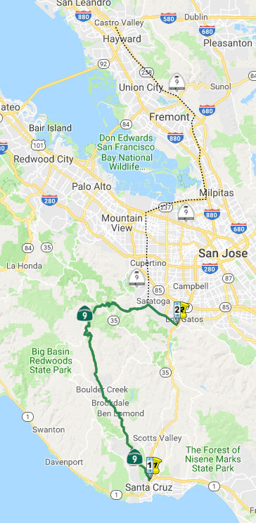 From Route 1 near Santa Cruz to Route 17 near Los Gatos via
Waterman Gap and Saratoga Gap and along the ridge between the San Lorenzo
and Pescadero Creeks.
From Route 1 near Santa Cruz to Route 17 near Los Gatos via
Waterman Gap and Saratoga Gap and along the ridge between the San Lorenzo
and Pescadero Creeks.
 Post 1964 Signage History
In 1963, this was defined to run "from Route 17 near Santa Cruz to Route 17 near Los Gatos via Waterman Gap and Saratoga Gap and along the ridge
between the San Lorenzo and Pescadero Creeks." In 1981, Chapter 292
changed the western origin to Route 17 Route 1
near Santa Cruz.
 Pre 1964 Signage History
As defined in 1934, Sign Route 9 was signed along the route from Santa Cruz to Milpitas via Redwood Park. This route consisted of the following segments:
There has been some discussion regarding whether Graham Hill Road was
ever considered as a replacement for the LRN 116 routing, but to date
no evidence has been found. Ocean Avenue in Santa Cruz does turn into
Graham Hill Road, and Ocean Ave was Route 17, so consideration of
Graham Hill Road might explain the Route 17 reference in the
definition, but (again) no evidence has been found yet to confirm
this.
(Source: Gribblenation Blog, "Graham Hill Road", 2/9/2026; AARoads Discussion, "Graham Hill Road", 2/9-13/2026)
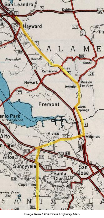
Originally, Milpitas was the end of the 1934 Sign Route 9. From Milpitas North, maps show the state highway, LRN 5, continuing along Sign Route 17 and Sign Route 21 to Mission San Jose (the specific routing is detailed below), and then continuing NW from Mission San Jose through Hayward into Castro Valley, where one segment turned W towards Dublin, Tracy, and Stockton, and another segment continue N into Oakland. In 1926 (before the state signage in 1934), the segment from Milpitas to Castro Valley was signed as part of US 48 (which continued NE to Stockton, all along LRN 5). In 1930, things changed: US 48 was truncated to end in Hayward at 14th Street (and Castro Valley/Mattox Rd), and US 101E was signed along LRN 5 from Oakland to San Jose (where it met US 101W). In 1931, US 48 was decommissioned and replaced with an extension of US 50; this also eliminated US 101E. This extension followed the existing LRN 5 and US 48 from Stockton to Castro Valley, but then turned N to continue into Oakland (along former US 101E) to meet US 40 at the Bay Bridge, all along an extension of LRN 5. The segment of LRN 5 from San Jose to Hayward appears to have been unsigned after US 48 was decommissioned, although US 101E signage appears to have remained until state highways were signed in 1934, as the 1934 state highway map shows US 101E. Signage from San Jose to Mission San Jose returned in 1934 (Sign Route 17 to Warm Springs, and Sign Route 21 to Mission San Jose, with Sign Route 21 continuing approx. along today's I-680 routing towards Danville, Walnut Creek, and Martinez. Mission Blvd N of Mission San Jose was unsigned state highway).
Sometime between 1946 and 1948, the routing from Milpitas to Castro Valley became part of an extension of Sign Route 9 ("sometime", because the 1946 state highway map doesn't show the extension, and the 1948 state highway map does). Sign Route 9 was cosigned with Sign Route 17 to Warm Springs, and cosigned with Sign Route 21 to Mission San Jose, and then just Sign Route 9 from Mission San Jose to Castro Valley.
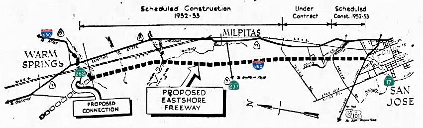 How does this correspond to current routes? This is where things get trickier, because everything
changed when the Eastshore/Nimitz Freeway (Sign Route 17 and later I-880)
was completed in the early 1950s (and things changed again when I-680 was
completed, taking over Sign Route 21). Before the Eastshore, LRN 5 ran out
of San Jose along Oakland Road (corresponding to today's (Old) Oakland
Road, Main Street (Milpitas), the Main Street/Abel Street couplet
(Milpitas), Milpitas Blvd, and Warm Springs Blvd). In Warm Springs, Sign
Route 17 headed NW on LRN 69 out of Warm Springs along today's Warm
Springs Ct., Lopes Road/Old Warm Springs Blvd, and Fremont Blvd (with a
rail crossing where the Warm Springs/South Fremont BART station is now).
With the construction of the Eastshore to the W of the previous LRN 69, a
short extension segment was added to LRN 69 extending to LRN 5. This
extension became Route 262.
How does this correspond to current routes? This is where things get trickier, because everything
changed when the Eastshore/Nimitz Freeway (Sign Route 17 and later I-880)
was completed in the early 1950s (and things changed again when I-680 was
completed, taking over Sign Route 21). Before the Eastshore, LRN 5 ran out
of San Jose along Oakland Road (corresponding to today's (Old) Oakland
Road, Main Street (Milpitas), the Main Street/Abel Street couplet
(Milpitas), Milpitas Blvd, and Warm Springs Blvd). In Warm Springs, Sign
Route 17 headed NW on LRN 69 out of Warm Springs along today's Warm
Springs Ct., Lopes Road/Old Warm Springs Blvd, and Fremont Blvd (with a
rail crossing where the Warm Springs/South Fremont BART station is now).
With the construction of the Eastshore to the W of the previous LRN 69, a
short extension segment was added to LRN 69 extending to LRN 5. This
extension became Route 262.
Sign Route 9 originally ended in Milpitas, at what is now Serra Way and Main Street, where it met Sign Route 17. N from there, LRN 5 was Sign Route 17 to Warm Springs, Sign Route 21 along Mission Blvd, and an unsigned route into Castro Valley along Mission Blvd (Sign Route 21 split off to the NE along Mission Road, which eventually became I-680). Around 1948, this was signed/cosigned with Sign Route 9.
As to the portion of Sign Route 9 from Milpitas down to Saratoga:
According to research by Tom Fearer, the original routing of Sign Route 9
traveled west from Milpitas along LRN 113 via Alviso-Milpitas Road and 1st
Street to Alviso. From Alviso, LRN 113 continued south on Gold Street and
west to Mathilda Avenue. The original alignment of LRN 113 is largely
buried under the Route 237 freeway. LRN 113 was realigned out of Alviso by
1958. Sign Route 9 then traveled south on LRN 114 via Mathilda Avenue to
the El Camino Real/US 101 in Sunnyvale. Sign Route 9 on LRN 114 took an
eastern jog on El Camino Real/US 101 before turning south on
Sunnyvale-Saratoga Road. Sign Route 9 continued south on LRN 114 via
Sunnyvale-Saratoga Road to Big Basin Way in downtown Saratoga. LRN 114
became the original alignment of Route 85 during the 1964 California
Highway Renumbering. Sign Route 9 traveled west from Saratoga on LRN 42 to
Big Basin State Park. LRN 42 and LRN 44 were developed off of preexisting
logging roads. LRN 44 and LRN 42 from Boulder Creek to Waterman Gap would
become Route 236 during the 1964 State Highway Renumbering. Maps in 1940
begin to show Sign Route 9 using LRN 116 to reach Route 1 in Santa Cruz.
(Source: Summarized from Gribblenation Blog "California State Route 9", August 2020)
This all changed in 1964, when the great renumbering happened. Sign Route 9 was split into multiple routes:
The only consistent portion that remained both Sign Route 9 and Route 9 was the portion from Santa Cruz to Saratoga, along LRN 116 and LRN 42.
 In Saratoga, the route of Sign Route 9 diverged from the present Route 9. Sign Route 9, as LRN 114,
proceeded North on Saratoga-Sunnyvale Road into Sunnyvale via Mathilda
Ave, thence to a jct with Alviso-Milpitas Road (currently signed as Route 237), and a junction with Bypass US-101 (LRN 68). It appears this segment
was defined in 1933. On October 18, 1956, the Highway Commission adopted
the routing for a future freeway location for Sign Route 9 (now Route 85)
from Bayshore Freeway north of Moffett Field, generally following Stevens
Creek to an existing Sign Route 9 location north of Azule near Saratoga.
In Saratoga, the route of Sign Route 9 diverged from the present Route 9. Sign Route 9, as LRN 114,
proceeded North on Saratoga-Sunnyvale Road into Sunnyvale via Mathilda
Ave, thence to a jct with Alviso-Milpitas Road (currently signed as Route 237), and a junction with Bypass US-101 (LRN 68). It appears this segment
was defined in 1933. On October 18, 1956, the Highway Commission adopted
the routing for a future freeway location for Sign Route 9 (now Route 85)
from Bayshore Freeway north of Moffett Field, generally following Stevens
Creek to an existing Sign Route 9 location north of Azule near Saratoga.
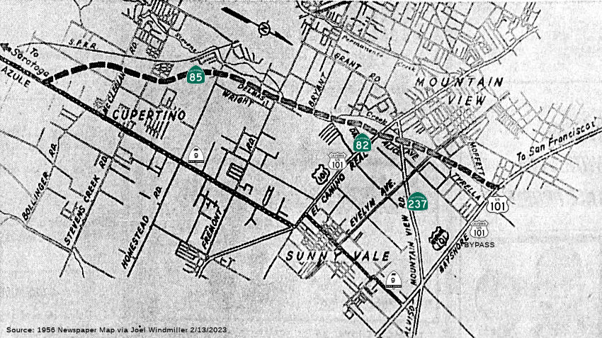 In 1956, public hearings were conducted for Sign Route 9 (future Route 85) between
Azula (Saratoga-Sunnyvale Road) and the Bayshore Freeway. Azule is located
at the railroad crossing on Sign Route 9 between Saratoga and Cupertino.
The proposed freeway (which is hard to map to present routings due to
street changes and the orientation of the map) runs roughly along the
lines of Stevens Creek and westerly of the present highway, just N of
Moffett Field. As of 1956, Sign Route 9 (now Sunnyvale-Saratoga Road and
Mathilda Ave, as the state signage for Sign Route 9 in this area was
dropped in the 1964 renumbering) met the Alviso-Mountain View Road (future
Route 237) just S of Moffett Field.
In 1956, public hearings were conducted for Sign Route 9 (future Route 85) between
Azula (Saratoga-Sunnyvale Road) and the Bayshore Freeway. Azule is located
at the railroad crossing on Sign Route 9 between Saratoga and Cupertino.
The proposed freeway (which is hard to map to present routings due to
street changes and the orientation of the map) runs roughly along the
lines of Stevens Creek and westerly of the present highway, just N of
Moffett Field. As of 1956, Sign Route 9 (now Sunnyvale-Saratoga Road and
Mathilda Ave, as the state signage for Sign Route 9 in this area was
dropped in the 1964 renumbering) met the Alviso-Mountain View Road (future
Route 237) just S of Moffett Field.
(Source: 1956 Newspaper Article via Joel Windmiller, 2/13/2023)
Sign Route 9 then proceeded on the current Route 237 alignment
into Milpitas. This was LRN 113. It ran east on the current Route 237
alignment to Sign Route 17 (LRN 69; now I-880). Before the current bridge
over the Guadalupe River was constructed, it took a route into Alviso via
Gold Street north and 1st Street southwest back to the current
Route 237 alignment.
Between Milpitas and Warm Springs, Sign Route 9 ran along Oakland Blvd to Mission Blvd; this was LRN 5 (and was cosigned with Sign Route 17). After completion of the Eastshore Freeway, Sign Route 9 ran N along LRN 69 (Sign Route 17, now I-880) to present-day Route 262 near Warm Springs. This segment, as LRN 69, was added to the state highway system in 1933.
Near Warm Springs, Sign Route 9 ran along the present-day Route 262 routing between Sign Route 17 (present-day I-880) and Sign Route 21 (present-day Route 680). This was part of a 1959 extension to LRN 69, and LRN 5, defined in 1909.
Between the present-day Route 262/I-680 junction near Warm Springs and Irvington, Sign Route 9 ran cosigned with Sign Route 21 to Irvington, near Mission San Jose along Mission Blvd. This segment was LRN 5, and was added to the state highway system in 1909.
Near the mission (at Mission Blvd), Sign Route 9 diverged, continuing as Sign Route 9 (but still LRN 5) along what is now Route 238, ending at US 50 (present-day I-580). This was also added in 1909.
 Status
Santa Cruz (Route 1) to Boulder Creek (SCR 13.08)
PPNO 4658: Rt 1/9 Intersection Modifications (05-SCr-9, PM 0.0/0.2)
The 2018 STIP, approved at the CTC March 2018 meeting, appears to increase the allocation for PPNO 4658, Rt 1/9 Intersection modifications, from $329K to $2.853M. This project, on Route 1 from SCR 17.5/17.7 and Route 9 from SCR 0.0/0.2, is in the city of Santa Cruz, at the junction of Route 1 and Route 9. Construct turn lanes and bike lanes.
The 2020 STIP, approved at the CTC March 2020 meeting,
retains the 2018 STIP programming.
(Source: March 2020 CTC Agenda, Item 4.7, 2020 STIP Adopted 3/25/2020)
In August 2020, the CTC approved for future
consideration of funding a project is located in Santa Cruz County on
Route 1 (05-SCr-1, PM 17.5/17.7) and Route 9 (05-SCr-9, PM 0.0/0.2) in the
City of Santa Cruz. The project proposes to construct turn lanes and bike
lanes. This project is fully funded and is currently programmed in the
2020 State Transportation Improvement Program (STIP) for a total of
$11,846,000 which includes Construction (capital and support) and Right of
Way (capital and support) with Regional Improvement Program funds, federal
and local dollars.
(Source: August 2020 CTC Agenda, Agenda Item
2.2c.(1))
Route 9 Felton Safety Improvements Project - 04-SCR-09 6.3/7.2
In August 2019, it was reported that new signs and
crosswalk improvements, designed to keep pedestrians and cyclists safer
and off Route 9 in Felton, have been installed. The signs provide
direction for pedestrians and cyclists — including students at San
Lorenzo Valley School District campus — through residential
neighborhoods and into downtown Felton while avoiding Route 9. The issue
has been an ongoing community concern due to heavy traffic and lack of
infrastructure on Route 9. The new signage directs pedestrians and
cyclists away from the busy roadway and over to Felton Empire Road,
connecting them with Gushee Street (~ SCR 5.986 to SCR 6.448). The route
is a lower-trafficked alternative to Route 9, which does not have bike
lanes or complete sidewalks.
(Source: Scotts Valley Patch, 8/23/2019)
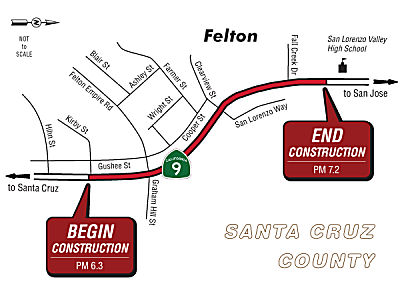 In February 2023, it was reported that Caltrans has earmarked another $3.3
million so it can proceed with final designs and right-of-way components
for the Route 9 Felton Safety Improvements Project. The money is coming
from the SHOPP. The project is set to construct pedestrian and bicycle
facilities to improve safety on Route 9 near Felton from Kirby Street (~
SCR 6.343) to north of Fall Creek Drive (SCR 7.083)—measures local
residents say are desperately needed given the immense traffic on the
route. New signs—possibly with flashing lights for pedestrian
safety—are being considered for the area south of Graham Hill Road.
Another is to be added near the place where a new sidewalk ends downtown
Felton. Construction on the $8.5 million initiative is scheduled to begin
in Spring 2025.
In February 2023, it was reported that Caltrans has earmarked another $3.3
million so it can proceed with final designs and right-of-way components
for the Route 9 Felton Safety Improvements Project. The money is coming
from the SHOPP. The project is set to construct pedestrian and bicycle
facilities to improve safety on Route 9 near Felton from Kirby Street (~
SCR 6.343) to north of Fall Creek Drive (SCR 7.083)—measures local
residents say are desperately needed given the immense traffic on the
route. New signs—possibly with flashing lights for pedestrian
safety—are being considered for the area south of Graham Hill Road.
Another is to be added near the place where a new sidewalk ends downtown
Felton. Construction on the $8.5 million initiative is scheduled to begin
in Spring 2025.
(Source: Press Banner, 2/3/2023)
In May 2023, it was reported that the draft of the
traffic study that seeks to fix problems with this portion of Route 9 has
been released, and the Santa Cruz County Regional Transportation
Commission is now seeking public feedback on the San Lorenzo Valley
Schools Circulation and Access Study. The Highway 9/San Lorenzo Valley
Complete Streets Corridor Plan was completed in 2019, after years of
public meetings, focus groups and surveys. It’s supposed to be a
guiding document to coordinate future transportation projects in the area.
Then, in January 2022, the RTC, SLVUSD, Caltrans, METRO and the County
decided to work together on an addition to the plan—to really
zoom-in on necessary improvements along Route 9 from Graham Hill Road to
the southern Glen Arbor Road intersection. The resulting study notes that
between January 2015 and December 2019 there were 49 crashes—mostly
things like rear-end collisions and sideswipes—in the studied area,
including 11 between El Solyo Heights Drive and the San Lorenzo Valley
High School driveway alone. It found 70% of students rely on personal
vehicles to get to the Tri-Campus, followed by 24% who take METRO or
SLVUSD buses and 6% who walk or use some sort of wheeled device. The study
found 66% of people want sidewalks on the south side of Route 9, and 62%
favored right-turn “pockets,” which make turning safer.
Fifty-five percent would like to see sidewalks on Route 9’s northern
side. Sixty percent want cycling infrastructure on the south side of Route 9, and 52% want cycling infrastructure on the north side of the
Caltrans-managed roadway. The draft plan recommends southbound shoulder
and sidewalk improvements from the high school driveway to Graham Hill
Road (which is already part of the Caltrans Felton Safety Project) and a
northbound continuous bike lane and shoulder from Graham Hill Road to
Rockys Café. It also recommends developing a pathway between Fall
Creek Drive and the high school. The plan suggests the removal of five to
seven parking spaces south of the high school traffic signal to establish
a student loading zone and restricting travel in the area between the high
school and the elementary school parking lots to northbound traffic, to
improve overall flow.
(Source: Press Banner, 5/19/2023)
In June 2025, there was an update on the Felton Safety
Project. This project proposes to construct a sidewalk from the San
Lorenzo Valley High School toward the intersection of Route 9 and Graham
Hill Road on the southbound side of Route 9. As part of this improvement,
shoulder widening will be constructed so that a minimum 4-foot wide
shoulder is provided on the southbound side of the highway at all
locations where the sidewalk is constructed at the highway grade. In
locations where the new sidewalk alignment is above the highway and behind
existing retaining walls, no shoulder widening is proposed. Signage and/or
rapid flashing pedestrian beacon improvements will be evaluated for the
project between postmiles 6.3 and 6.45 (South of Graham Hill Road).
Detailed proposals for this location will be developed during the Project
Approval and Environmental Document phase. If the sidewalk cannot be
constructed all the way to Graham Hill Road, the sidewalk and shoulder
improvements will be carried to a logical stopping point. A signalized
flashing beacon pedestrian crossing will be added at or near the terminus
of the sidewalk improvements if they are stopped prior to Graham Hill Road
/ Felton Empire Road. These design details will be further evaluated
during the (PAED) Project Approval and Environmental Document phase of the
project. At spot locations, the sidewalk will be reduced in width to 32
inches per the allowable standards in the current Caltrans Design
Information Bulletin (DIB) 82-06 Pedestrian Accessibility Guidelines for
Highway Projects. Additionally, non-standard sidewalk widths of 4 feet
will be used in severely constrained locations, such as above retaining
walls and in front of environmentally sensitive areas or adjacent
residences. Where possible throughout the project, a sidewalk width of 6
feet will be constructed. In the Project Approval and Environmental
Document phase, when design surveys are received, potential wider path or
sidewalk improvements can additionally be investigated for the northern
area of the project from postmiles 6.8 to 7.2.
(Source: Caltrans State Rte 9 Felton Safety Improvements Page, accessed 9/11/2025)
In June 2025, it was reported that construction on the
Felton Safety Project was expected to start in Fall 2025 on the sidewalk
on Route 9 between Graham Hill Road and San Lorenzo Valley High School.
The project is part of a four-year process of safety upgrades for walking
and biking on the highway in Felton. Another project proposed to start
construction in 2027 and end in 2029 would add bike lanes, sidewalks,
upgraded crosswalks and other improvements on Route 9 throughout downtown
Felton. It would include: * Sidewalks and painted bike lanes through much
of downtown Felton, from Laurel Drive to Graham Hill Road. * A pedestrian
walkway from Route 9 to the bridge over the San Lorenzo River, just inside
Henry Cowell Redwoods State Park. * Repainted crosswalks, with curb
extensions at some crosswalks. * Redesigned bus stops. * Safety upgrades
for the intersection of Graham Hill Road and Route 9. * A painted bike
lane in the City of Santa Cruz from Encinal Street to Golf Club Drive. A
third set of safety improvements on Route 9 has been planned for downtown
Boulder Creek. The project is not fully funded and lacks an environmental
review. The plan tentatively includes: * Sidewalks and bike lanes between
Mountain Street and Bear Creek Road. * Curb extensions at some crosswalks.
* Center median islands to slow traffic. * A potential new stop sign at
the intersection with Bear Creek Road.
(Source: Santa Cruz Local, 6/13/2025)
In August 2025, the CTC was informed of the following
SHOPP Safety sub-allocation by Caltrans: $8,000,000. 05-SCr-9 6.3/7.2.
PPNO 05-3012; ProjID 0519000136; EA 1M400. Route 9 Near Felton, from Kirby
Street to 0.1 mile north of Fall Creek Drive. Construct pedestrian and
bicycle infrastructure to improve safety. This project will reduce
the number and severity of collisions. CEQA - CE, 11/16/2022;
Re-validation 01/06/2025 NEPA - CE, 11/16/2022; Re-validation 12/12/2024.
Allocation Date: 06/24/25. Pre-Construction Phase: Budgeted (Actual,
if different): PA&ED $2,070,000 ($1,314,764);
PS&E $3,089,300 ($2,630,839); R/W Sup $1,229,000 ($1,004,967).
Construction Phase - Programmed (Allocation, if different):
CON ENG $1,901,000; CONST $5,785,000.
(Source: August 2025 CTC Agenda, Agenda Item 2.5f.(3) #4)
San Lorenzo River Bridge № 36-0052 / Kings Creek Bridge № 36-0054 (PM 15.49) Replacement (05-Santa Cruz-9 PM 13.6/15.5)
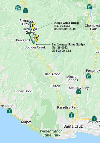 The following project was included in the final adopted 2018 SHOPP in March 2018: PPNO 2655. 05-Santa Cruz-9 13.6/15.5. Route 9 Near Boulder Creek, at San Lorenzo River Bridge № 36-0052
(PM SCR 13.61) and Kings Creek Bridge № 36-0054 (PM SCR 15.49).
Replace bridges to maintain standards of safety and reliability. Begin
Con: 3/4/2022. Total Project Cost: $23,210.
The following project was included in the final adopted 2018 SHOPP in March 2018: PPNO 2655. 05-Santa Cruz-9 13.6/15.5. Route 9 Near Boulder Creek, at San Lorenzo River Bridge № 36-0052
(PM SCR 13.61) and Kings Creek Bridge № 36-0054 (PM SCR 15.49).
Replace bridges to maintain standards of safety and reliability. Begin
Con: 3/4/2022. Total Project Cost: $23,210.
The 2020 SHOPP, approved in May 2020, included the
following Bridge Preservation item of interest (carried over from the 2018
SHOPP): 05-Santa Cruz-9 PM 13.6/15.5 PPNO 2655 Proj ID 0516000078 EA
1H470. Route 9 near Boulder Creek, at San Lorenzo River Bridge №
36-0052 (PM 13.61) and Kings Creek Bridge № 36-0054 (PM 15.49).
Replace bridges to maintain standards of safety and reliability.
Programmed in FY21-22, with construction scheduled to start in July 2022.
Total project cost is $23,210K, with $12,588K being capital (const and
right of way) and $10,622K being support (engineering, environmental,
etc.).
(Source: 2020 Approved SHOPP a/o May 2020)
In March 2021, the CTC approved for future
consideration of funding: 05-SCr-9, PM 13.6/15.5. San Lorenzo River
Bridge and Kings Creek Bridge Replacement Project. Replace two
bridges on Route 9 in Santa Cruz County. (MND) (PPNO 2655) (SHOPP). The
project is located in Boulder Creek in Santa Cruz County. The Department
proposes to replace the San Lorenzo River Bridge at post mile 13.6 and
Kings Creek Bridge at post mile 15.5 on Route 9 in Santa Cruz County. This
project is fully funded and programmed in the 2020 SHOPP for a total of
$23,210,000 which includes Construction (capital and support) and Right of
Way (capital and support). Construction is estimated to begin in Fiscal
Year 2022-2023. The scope, as described for the preferred alternative, is
consistent with the project scope programmed by the Commission in the 2020
SHOPP. A Mitigated Negative Declaration (MND) has been completed. The
project will result in less than significant impacts to the environment
after mitigation. The following resource areas may be impacted by the
project: biological resources. Avoidance and minimization measures will
reduce any potential effects on the environment. These measures include,
but are not limited to, contract provisions for the cleanup of
project-related hazardous materials spills and the establishment of
environmentally sensitive area fencing for sensitive habitat.
(Source: March 2021 CTC Agenda, Agenda Item
2.2c.(1))
In March 2021, the CTC approved the following
pre-construction SHOPP SB1 support phase allocation(s): (2b) #7.
$2,884,000 (PS&E); $600,000 (R/W Sup; $888,000 programmed). 05-SCr-9
13.6/15.5. PPNO 05-2655; ProjID 0516000078; EA 1H470. Route 9 Near Boulder
Creek, at San Lorenzo River Bridge № 36-0052 (PM 13.61) and Kings
Creek Bridge № 36-0054 (PM 15.49). Replace bridges to maintain
standards of safety and reliability. (Concurrent consideration of funding
under Resolution E-21-22; March 2021.) (Nine month time extension for
PS&E and R/W Sup approved under Waiver 20-31; June 2020.) Prog year
21-22. Media reports indicated that this was a $2 million allocation, but
the total was closer to $3.488 million, when PS&E and R/W sup costs
are combined.
(Source: March 2021 CTC Agenda, Agenda Item
2.5b.(2b) #7; Paso Robles Daily News, 3/26/2021)
In May 2021, the CTC amended this project in the SHOPP:
05-SCr-9 13.6, 15.5 PPNO 2655 ProjID 0516000078 EA 1H470. Route 9 Near
Boulder Creek, at San Lorenzo River Bridge № 36-0052 (PM 13.61) and
Kings Creek Bridge № 36-0054 (PM 15.49). Replace bridges to maintain
standards of safety and reliability. Amend to adjust costs. Increase
construction capital ($11,928K → $16,165K) because of necessary
additional roadway replacement, increased clearing and tree removal, a
temporary creek diversion, and an increase in cast-in-drilled-hole piles.
Revised total: $27,447K.
(Source: May 2021 CTC Agenda, Agenda Item 2.1a.(1d)
#28)
In June 2021, the CTC amended this project in the 2020
SHOPP: 05-SCr-9 13.6 PPNO 2655 ProjID 0516000078 EA 05-1H470. Route 9 Near
Boulder Creek, at San Lorenzo River Bridge № 36-0052 (PM 13.61) and
Kings Creek Bridge № 36-0054 (PM 15.49). Replace bridges to maintain
standards of safety and reliability. Note: Increase construction capital
because it has been determined that the girders are too large and heavy to
transport as one unit and will instead need to be shipped and spliced
onsite, at higher cost. Const Cap $16,165K $17,765K;
Total $27,447K $29,047K.
(Source: June 2021 CTC Agenda, Agenda Item
2.1a.(1d) #35)
In March 2024, the CTC approved the following
preconstruction SHOPP SB1 phase allocation: $900,000. 05-SCr-9 13.61. PPNO
05-2655; ProjID 0516000078; EA 1H470. Route 9 Near Boulder Creek, at San
Lorenzo River Bridge № 36-0052 and Kings Creek Bridge №
36-0054 (PM 15.49). Outcome/Outputs: Replace bridges to maintain standards
of safety and reliability. Future consideration of funding approved under
Resolution E-21-22; March 2021. Concurrent Amendment under Resolution
G-24-34, SHOPP Amendment 24H-000; March 2024. Allocation: PS&E
$600,000; RW Sup: $300,000.
(Source: March 2024 CTC Agenda, Agenda Item 2.5b.(2b) #9)
In January 2025, the CTC approved for future
consideration of funding the San Lorenzo River Bridge and Kings Creek
Bridge Replacement Project, for which an MND and Addendum have been
completed: Route 9 in Santa Cruz County. Replace bridges on Route 9 at San
Lorenzo River Bridge № 36-0052 (at PM 13.6) and Kings Creek Bridge
№ 36-0054 (at PM 15.5) in Santa Cruz County. (PPNO 2655; 05-SCR-9,
PM 13.6/15.5). The project is located on Route 9 at PM 13.6 and PM 15.5,
in Santa Cruz County. The Department proposes to replace bridges to
maintain standards of safety and reliability. The project is currently
programmed in the 2024 SHOPP. The total programmed amount, which includes
Right of Way (Support and Capital) and Construction (Support and Capital)
is $21,150,000. Construction will begin in 2024-25. The scope, as
described for the preferred alternative, is consistent with the project
scope as programmed by the Commission in the 2024 SHOPP.
(Source: January 2025 CTC Agenda, Agenda Item 2.2c.(2) #2)
In January 2025, the CTC approved the following SHOPP
Construction Phase allocation: $19,735,000. 05-SCr-9 13.61. PPNO 05-2655;
ProjID 0516000078; EA 1H470. Route 9 near Boulder Creek, at San Lorenzo
River Bridge № 36-0052 and Kings Creek Bridge № 36-0054 (PM
15.49). Replace bridges to maintain standards of safety and reliability.
CEQA - MND, 2/2/2021; Re-validation 9/3/2024. NEPA - FONSI, 2/2/2021;
Re-validation 9/3/2024. Future consideration of funding approved under
Resolution E-21-22; March 2021. Concurrent addendum for the previously
approved Future Consideration of Funding under Resolution E-25-10A;
January 2025. As part of this allocation request, the Department is
requesting to extend the completion of CONST and CON ENG an additional 5
months beyond the 36 month deadline. Pre-Construction Phase: Budgeted (Actual,
if different): PA&ED $2,692,000 ($2,262,492);
PS&E $3,662,658 ($3,291,290); R/W Sup $684,090 ($483,194).
Construction Phase - Programmed (Allocation, if different):
CON ENG $4,600,000; CONST $15,150,000.
(Source: January 2025 CTC Agenda, Agenda Item 2.5b.(1) #8)
In August 2025, the CTC approved a request for an
additional $1,897,000 (12.5 percent increase) in Construction Capital for
the SHOPP Bridge Rehabilitation and Replacement project on Route 9 (EA
1H470, PPNO 2655). This project is located on Route 9 near Boulder Creek,
at the San Lorenzo River Bridge (№ 36-0052) and Kings Creek Bridge
(№ 36-0054), in Santa Cruz County. The project will replace
the bridges. In April 2025, the Department advertised the contract and
held bid opening in June 2025. The contract received six bids, of
which the lowest bid is 13.0 percent above the Engineer’s Estimate
(EE) of the bid items. The remaining five bids range from 15.8 to
36.6 percent over the EE. The cost increases on this project are largely
attributed to temporary shuttle service, job site management, structure
excavation, and bridge removal. Despite factoring the
project’s location into the EE, the contractor still cited the rural
location of the bridges and the constrained work locations as the reason
for the higher than anticipated unit cost. SHOPP Update: $1,897,000.
05-SCr-9 13.6/15.5. PPNO 05-2655; ProjID 0516000078; EA 1H470. Route 9
near Boulder Creek, at San Lorenzo River Bridge № 36-0052 and Kings
Creek Bridge № 36-0054 (PM 15.49). Outcome/Outputs: Replace bridges
to maintain standards of safety and reliability. Total revised amount
$17,032,000. Supplemental funds are needed to award. CEQA - MND,
02/02/2021; Re-validation 09/03/2024 NEPA - FONSI, 02/02/2021;
Re-validation 09/03/2024. Future consideration of funding approved under
Resolution E-21-22; March 2021. Addendum to the previously approved future
consideration of funding approved under Resolution E-25-10A; January 2025.
Allocation: Construction Phase - Programmed (Allocation, if
different): CONST $15,135,000 ($17,032,000).
(Source: August 2025 CTC Agenda, Agenda Item 2.5e.(12))
Boulder Creek (SCR 13.08) to Route 35 (SCR 27.072)
Waterman Gap Fish Passage Bridge (05-SCr-9 19.2)
In June 2024, the CTC authorized the following
pre-construction-phase SHOPP project allocation: $3,401,000. 05-SCr-9
19.2. PPNO 05-2880F; ProjID 0523000059; EA 1K901. Route 9 At the San
Lorenzo River, in Castle Rock State Park. Outcome/Outputs: Replace
Waterman Gap culvert with a bridge to improve fish passage. Includes
federal Culvert Aquatic Organism Passage (AOP) Grant amount of $6,000,000.
(Additional contribution of $2,000,000 from State Parks.) Additional
Contribution: PS&E $300,000 from State Parks. Allocation (Programmed,
if different): PS&E $3,014,000 ($2,824,000);
RW Sup $387,000.
(Source: June 2024 CTC Agenda, Agenda Item 2.5b.(2a) #16)
In June 2025, the CTC revised this project in the 2024
SHOPP: 05-SCr-9 19.2. PPNO 05-2880F; ProjID 0523000059; EA 1K901. Route 9
At the San Lorenzo River, in Castle Rock State Park. Replace Waterman Gap
culvert with a bridge to improve fish passage. Includes federal Culvert
Aquatic Organism Passage (AOP) Grant amount of $6,000,000. (Additional
contribution of $2,000,000 from State Parks.) Allocation Changes ($ ×
$1000): R/W Cap $55 $81; Const Cap $6,253
$9,171; TOTAL $11,707 $14,651. Note:
Update right of way and construction capital to address refined design in
bridge profile, and a refined structure estimate for items such as
mobilization, bridge removal, irrigation, National Pollutant Discharge
Elimination System (NPDES), and streambed restoration of fish passage.
(Source: June 2025 CTC Agenda, Agenda Item 2.1a.(1d) #41)
In June 2026, the CTC approved the following allocation
for SHOPP construction project phases (Con Sup, R/W Cap, Const Cap):
$12,531,000. 05-SCr-9 19.2. PPNO 05-2880F; ProjID 0523000059; EA 1K901.
Route 9 At the San Lorenzo River, in Castle Rock State Park. Replace
Waterman Gap culvert with a bridge to improve fish passage. Includes
federal Culvert Aquatic Organism Passage (AOP) Grant amount of $6,000,000.
(Additional contribution of $1,000,000 CONST, $700,000 CON ENG, $300,000
PS&E from State Parks.) CEQA - CE, 05/24/2024; Re-validation
04/22/2026 NEPA - CE, 05/24/2024; Re-validation 04/22/2026.
Pre-Construction Expenditures: Budgeted (Expended):
PA&ED $300,000; PS&E $3,014,000 ($2,828,361); RW
Sup $387,000 ($214,305). Construction Phase Allocation ($
× $1000): Budgeted (Actual, if different): Con Sup
$2,759; Const Cap $10,802.
(Source: June 2026 CTC Agenda, Agenda Item 2.5b.(3) #2)
Route 35 (SCR 27.072) to Route 17 near Rinconada
In March 2017, the CTC amended the SHOPP to include almost $12M in funding on Route 9 near Saratoga, from Santa Cruz County line to Sanborn Road (4-SCl-9 0.0/4.8). Remove slide debris, repair roadway, and establish safe working conditions of failed slope to initiate geotechnical investigations.
In December 2018, the CTC amended the SHOPP to include 05-SCr-9. PM 10.8.
PPNO 2847. Project ID 0518000115. Route 9 Near Brookdale, south of Western
Avenue. Construct side hill viaduct extension with cutoff retaining wall,
restore roadway and facilities, and install permanent erosion control.
Construction start: 10/27/2021. Total est. cost: $6,910,000.
(Source: December 2018 CTC Minutes, Agenda Item
2.1a(1) Item 9)
In August 2011, the CTC approved $479,000 in SHOPP funding to stabilize and repair slope at four locations in Saratoga, from Skyline Boulevard (~ 009 SCL 0.026) to Toll Gate Road (~ 009 SCL 6.678), damaged by heavy rainfall.
In June 2011, the CTC approved for future consideration of funding a project that will make safety upgrades on Route 9 from 2.5 miles north of Route 35 (~ 009 SCL 2.5) to 6th Street, near Saratoga (~ 006 SCL 7.099). The project is not fully funded. The project is programmed in the 2010 State Highway Operation and Protection Program. Total estimated project cost is $13,427,000 for capital and support. The scope as described for the preferred alternative is consistent with the project scope programmed by the Commission in the 2010 State Highway Operation and Protection Program.
Saratoga Creek Bridge (04-SCl-9, PM 4.75/4.9)
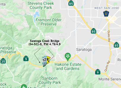
In May 2016, the CTC approved additional SHOPP funding on Route 9 near Saratoga, PM 4.9, at Saratoga Creek Bridge № 37-0074. Replace bridge. The age of the existing bridge at this location makes it eligible for the National and California historic registers. The two alternatives in the Project Initiation Document (PID) have been expanded to six alternatives during the PA&ED phase and has led to an increase in support for that phase. A change in the project schedule is necessary due to the expanded alternatives in the environmental document, public input and right-of-way acquisition efforts for multiple properties, including a private picnic and campground resort adjacent to the existing bridge. These changes add $1,600,000 to the cost of the project.
The following project was included in the final adopted 2018 SHOPP in March 2018: PPNO 0386F. 04-Santa Clara-9 4.9. Route 9 Near Saratoga, at Saratoga Creek Bridge № 37-0074. Replace bridge. Begin Con: 10/19/2020. Total Project Cost: $24,569K.
In May 2019, the CTC approved the following SHOPP
Amendment: 04-SCl-9 4.9 PPNO 0386F. ProjID 0412000409. Route 9 Near
Saratoga, at Saratoga Creek Bridge № 37-0074. Replace bridge. Delay
construction completion to FY21-22. Note: The delivery of the project is
delayed by two years due to complex right of way acquisition of multiple
properties. Also, due to the historical aspect of the bridge, additional
outreach was required, resulting in the need to develop a range of design
options.
(May 2019 Agenda Item 2.1a.(1) Amend Item 26)
In March 2020, the CTC approved the following project
for future consideration of funding: Route 9 (04-SCl-9, PM 4.75/4.9) in
Santa Clara County. Construct a new bridge within the existing bridge or
replace it to address seismic and structural concerns in Santa Clara
County. (PPNO 0386F) This project is located near the City of Saratoga in
Santa Clara County and proposes to address seismic and structural concerns
for the Saratoga Creek Bridge on Route 9 in Santa Clara County at PM SCL
4.85, near the intersection of Route 9 and Sanborn Road. The project
proposes to construct a new bridge within the existing bridge or replace
the existing bridge with a new bridge. This project is fully funded and
currently programmed in the 2018 State Highway Operation Protection
Program (SHOPP) for a total of $28,173,000 which includes Construction
(capital and support) and Right of Way (capital and support). Construction
is estimated to begin in Fiscal Year 2022-2023. The CTC also approved the
following financial allocation: 04-SCI-9 PM 4.9 PPNO 0386F. ProjID
0412000409. EA 3G630. Route 9 near Saratoga, at Saratoga Creek Bridge
№ 37-0074. Replace bridge. (Concurrent consideration of funding
under Resolution E-20-22; March 2020.) (Concurrent Amendment under SHOPP
Amendment 18H-015; March 2020.) (Nine month time extension for PS&E
and R/W Sup approved under Waiver 19-29; June 2019.) Financial allocation:
PS&E $4,200,000 R/W Sup $1,200,000
(March 2020 CTC Agenda, Agenda Item 2.2c.(5),
2.5b.(2b) #10)
The 2020 SHOPP, approved in May 2020, included the
following Bridge Preservation item of interest (carried over from the 2018
SHOPP): 04-Santa Clara-9 PM 4.9 PPNO 0386F Proj ID 0412000409 EA 3G630.
Route 9 near Saratoga, at Saratoga Creek Bridge № 37-0074. Replace
bridge. Programmed in FY21-22, with construction scheduled to start in
October 2022. Total project cost is $35,843K, with $24,543K being capital
(const and right of way) and $11,300K being support (engineering,
environmental, etc.).
(Source: 2020 Approved SHOPP a/o May 2020)
In October 2022, the CTC amended the SHOPP as follows:
04-SCl-9 4.9. PPNO 04-0386F; ProjID 0412000409; EA 3G630. Route 9 Near
Saratoga, at Saratoga Creek Bridge № 37-0074. Replace bridge. This
is a Construction Manager/General Contractor (CMGC) project.
Allocation Changes ($ × 1,000): Const Cap: $15,432 ⇨ $13,402;
Total $35,843 ⇨ $33,813. Note: Split project EA 3G630/PPNO 04-0386F
into three mitigation project EAs 3G631/PPNO 04-2914W, 3G632/PPNO
04-2914X, and 3G633/PPNO 04-2914Y. Update description to include CMGC as
the new recommended delivery method.
(Source: October 2022 CTC Agenda, Agenda Item
2.1a.(1d) #10)
In October 2022, the CTC approved the following
construction phase allocation: $17,742,000. 04-SCl-9 4.9. PPNO 04-0386F;
ProjID 0412000409; EA 3G630. Route 9 Near Saratoga, at Saratoga Creek
Bridge № 37-0074. Outcome/Output: Replace bridge. This is a
Construction Manager/General Contractor (CMGC) project. Programmed
Allocation:CON ENG $3,100,000; CONST $13,402,000. CEQA - EIR, 1/28/2020;
Re-validation 8/15/2022. NEPA - FONSI, 1/28/2020; Re-validation 8/15/2022.
Future consideration of funding approved under Resolution E-20-22; March
2020. Four month time extension for CONST and CON ENG approved under
Waiver 22-73; June 2022. Concurrent Amendment under SHOPP Amendment
22H-004; October 2022.
(Source: October 2022 CTC Agenda, Agenda Item
2.5b.(1) #4)
In December 2022, the CTC approved for future
consideration of funding the following project for which a Final
Environmental Impact Report (FEIR) and an Addendum have been completed:
Route 9 in Santa Clara County (04-SCl-9, PM 4.75/4.9). Road deck will be
widened eight feet to meet design standards of bridge safety, on Route 9,
in Santa Clara County. (PPNO 04-0386F). This project is located near the
City of Saratoga, in Santa Clara County, and proposes to address seismic
and structural concerns for the Saratoga Creek Bridge on Route 9, in Santa
Clara County at postmile 4.85, near the intersection of Route 9 and
Sanborn Road. The project proposes to replace the existing bridge with a
new bridge. This project is fully funded and currently programmed in the
2022 SHOPP for a total of $33,813,000. Construction will begin in 2022-23.
Three mitigation projects have been split from this project – EA
3G631/PPNO 04-2914W, programmed for $500,000, EA 3G632/PPNO 04-2914X,
programmed for $290,000, and EA 3G633/PPNO 04-2914Y, programmed for
$1,240,000. The scope, as described for the preferred alternative, is
consistent with the project scope programmed by the Commission in the 2022
SHOPP. A FEIR was prepared because of potential biological resource
impacts. A copy of the FEIR has been provided to Commission staff. The
Commission approved the project for future consideration of funding on
March 25, 2020, under Resolution E-20-22. During the design phase the
impact footprint was reduced, and the riparian area was redefined in
coordination with CDFW. The Department subsequently completed an Addendum
to the FEIR pursuant to the California Environmental Quality Act. The
Department has approved this project for construction. This approval and
the Addendum satisfy the environmental requirements for this stage of the
planning process.
(Source: December 2022 CTC Agenda, Agenda Item
2.2c.(8))
In February 2023, it was reported that Caltrans is
building a new Saratoga Creek bridge after an investigation revealed
seismic and structural concerns. The bridge will be closed during
construction, which is expected to start in March 2023. The bridge is
located on Highway 9 at mile marker 4.9, between Saratoga in Santa Clara
County and Felton in Santa Cruz County. The construction project will
replace the existing bridge, though the new bridge will retain the outer,
visible portion of the stone bridge. The project is expected to wrap up by
December 2023.
(Source: Mercury News, 2/8/2023)
In July 2005, the CTC considered relinquishment of right of way in the City of Saratoga, between Saratoga-Los Gatos Road and 0.13 kilometer west of Sixth Street ( 4-SCl-9-KP 11.3/11.9, PM 7.02/7.39), consisting of nonmotorized transportation facilities, namely sidewalks.
In February 2017, it was reported that the first three phases of the
Highway 9 Pedestrian/Bicycle Improvement Project are complete and the
fourth phase was set to begin. Phase four of the Route 9 project involves
pedestrian improvements from Fruitvale Avenue (~ 009 SCL 8.853) to El
Camino Grande (~ 009 SCL 9.266) in Saratoga, and from Daves Avenue (~ 009
SCL 10.002) to Greenwood Road (~ 009 SCL 10.238) in Monte Sereno. Phase
four is expected to be completed by the end of 2017.
(Source: Mercury News, 2/23/2017)
In August 2018, it was reported that plans recently approved unanimously
by the Los Gatos Town Council call for a $112,000 LED flashing beacon to
be installed at the intersection of Route 9 and Massol Ave (SCL 10.884).
The crosswalk currently has a round beacon that can be triggered by
pedestrians or bicyclists, but the flashing beacon is rectangular,
resembling the emergency flashers on police cars. The intersection will
also be getting green bike lanes. Sixteen accidents were reported at the
Route 9/Massol intersection between 2013 and 2017, half of which resulted
in injuries, a recently-completed Route 9 safety and traffic study shows.
The traffic study looked at alternatives to the flashing beacon, including
a stop light and a HAWK system. HAWKs use double red signals and one
yellow signal to grab drivers’ attention. A HAWK installation could
cost about $476,000, but would likely need a federal grant to pay for it.
With no guarantee the grant would be approved, that idea was shelved. A
stoplight could cost approximately $722,000 and would likely cause
unacceptable traffic delays. The Los Gatos Town Council also considered
adding a raised crosswalk to the intersection that would ramp the
crosswalk up to sidewalk level. But there was concern that bicyclists
going as fast as 30 mph could be “launched” into the air when
they hit the elevated section, so that option was tabled and will be
considered later. Funding for the flashing beacon has not been approved,
but the Town Council will likely do that in February during its mid-year
budget review. Design and construction of the new crosswalk will take
another six months.
(Source: Mercury News, 8/29/2018)
 Naming
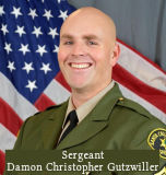 The portion of Route 9 between Lower Glen Arbor Road (SCR
8.110) to Western Avenue (SCR 11.131) is named the “Sergeant
Damon Christopher Gutzwiller Memorial Highway”. It was named
in memory of Damon Christopher Gutzwiller, who was born in Santa Monica,
California in June 1981. He attended schools in the County of Santa Cruz,
graduating from Aptos High School in 1999 and earning an associate degree
from Cabrillo College in Aptos. While attending Cabrillo College, Damon
began working for the Santa Cruz County Sheriff’s Office at Cabrillo
College as a Campus Police Assistant and Office Specialist. It was during
these years that Damon was introduced to the Santa Cruz County
Sheriff’s Office Volunteer Program and became a valued member of the
volunteer staff, becoming a volunteer member of the Santa Cruz County
Search and Rescue team where he began serving as a member in 2005. In 2006
Damon was hired by the Santa Cruz County Sheriff’s Office and
attended the Gavilan College Police Academy, graduating with class SB 79.
During his career with the Santa Cruz County Sheriff’s Office, Damon
worked as a patrol deputy, court security bailiff, field training officer,
TASER instructor, SWAT operator, Unmanned Aerial Systems Operator, CSI
detective, and Alcohol Compliance Officer, promoting to Sergeant in 2019,
when he supervised a patrol shift. On the afternoon of June 6, 2020, in
Ben Lomond, California, while Damon was supervising a
suspicious-circumstance call related to potential bombmaking material, he
was ambushed and shot by a lone suspect and passed away on the scene. The
suspect also shot another deputy, detonated a bomb, and struck the same
deputy with a car, engaging in a gun battle with two Department of the
California Highway Patrol officers before fleeing the scene. The suspect
was apprehended shortly after Damon’s passing. Chaptered by
Secretary of State - Res. Chapter 106, Statutes of 2024, ACR 124,
06/20/24.
The portion of Route 9 between Lower Glen Arbor Road (SCR
8.110) to Western Avenue (SCR 11.131) is named the “Sergeant
Damon Christopher Gutzwiller Memorial Highway”. It was named
in memory of Damon Christopher Gutzwiller, who was born in Santa Monica,
California in June 1981. He attended schools in the County of Santa Cruz,
graduating from Aptos High School in 1999 and earning an associate degree
from Cabrillo College in Aptos. While attending Cabrillo College, Damon
began working for the Santa Cruz County Sheriff’s Office at Cabrillo
College as a Campus Police Assistant and Office Specialist. It was during
these years that Damon was introduced to the Santa Cruz County
Sheriff’s Office Volunteer Program and became a valued member of the
volunteer staff, becoming a volunteer member of the Santa Cruz County
Search and Rescue team where he began serving as a member in 2005. In 2006
Damon was hired by the Santa Cruz County Sheriff’s Office and
attended the Gavilan College Police Academy, graduating with class SB 79.
During his career with the Santa Cruz County Sheriff’s Office, Damon
worked as a patrol deputy, court security bailiff, field training officer,
TASER instructor, SWAT operator, Unmanned Aerial Systems Operator, CSI
detective, and Alcohol Compliance Officer, promoting to Sergeant in 2019,
when he supervised a patrol shift. On the afternoon of June 6, 2020, in
Ben Lomond, California, while Damon was supervising a
suspicious-circumstance call related to potential bombmaking material, he
was ambushed and shot by a lone suspect and passed away on the scene. The
suspect also shot another deputy, detonated a bomb, and struck the same
deputy with a car, engaging in a gun battle with two Department of the
California Highway Patrol officers before fleeing the scene. The suspect
was apprehended shortly after Damon’s passing. Chaptered by
Secretary of State - Res. Chapter 106, Statutes of 2024, ACR 124,
06/20/24.
(Image source: Officer Down Memorial Page)
 Scenic Route
[SHC 263.3] From Route 1 near Santa Cruz to Route 236 near Boulder Creek; and from Route 236 near Boulder Creek to Route 236 near Waterman Gap; and from Route 236 near Waterman Gap to Route 35; and from Saratoga to Route 17 near Los Gatos; and from Blaney Plaza in Saratoga to Route 35.
Eligible for Scenic Highway status per [SHC 263.2]. The following portions have been officially designated as Scenic Highway and are signed:
 Interregional Route
[SHC 164.10] Between the north urban limits of Santa Cruz and the south urban limits of San Jose.
 Other WWW Links
 National Trails
 The former Sign Route 9 portion of this route from US 50 (now
I-580) near Hayward to near San Jose (the former LRN 5 spur towards San
Jose) was part of the Pacific Highway.
The former Sign Route 9 portion of this route from US 50 (now
I-580) near Hayward to near San Jose (the former LRN 5 spur towards San
Jose) was part of the Pacific Highway.
 The Pacific Highway portion of this route was also part of the California-Banff Beeline Highway.
 Interstate Submissions
In November 1957, the California Department of Highways proposed the designation I–9 for what is now I-405.
 Statistics
Overall statistics for Route 9:
 Pre-1964 Legislative Route
 The route that would become LRN 9 was defined in the
first set of highway bonds in 1909, with a rough routing of "San Fernando
to San Bernardino". It was extended in 1933 to run to [LRN 2] (US 101)
near Montalvo. Montvalvo is a community within the city of Ventura, CA;
basically, it is near where Victoria Ave and US 101 meet.
The route that would become LRN 9 was defined in the
first set of highway bonds in 1909, with a rough routing of "San Fernando
to San Bernardino". It was extended in 1933 to run to [LRN 2] (US 101)
near Montalvo. Montvalvo is a community within the city of Ventura, CA;
basically, it is near where Victoria Ave and US 101 meet.
By 1935, LRN 9 was codified in the highway code as:
 Only the first segment was a primary route. Note that LRN 2 near Montvalvo is not
the current end of Sign Route 118, which corresponded to LRN 9. Why? The
answer is simple: Telephone Road in Ventura was Sign Route 118 and LRN 9
between Wells Road (Sign Route 118) and US 101 near Montvalvo. What is now
Route 118 to Sign Route 126 was the second segment of the original LRN 154, [LRN 9] near Saticoy to [LRN 79].
Only the first segment was a primary route. Note that LRN 2 near Montvalvo is not
the current end of Sign Route 118, which corresponded to LRN 9. Why? The
answer is simple: Telephone Road in Ventura was Sign Route 118 and LRN 9
between Wells Road (Sign Route 118) and US 101 near Montvalvo. What is now
Route 118 to Sign Route 126 was the second segment of the original LRN 154, [LRN 9] near Saticoy to [LRN 79].
In 1957, Chapter 1911 changed the west end of the first segment from [LRN 2] (US 101) near Montalvo to [LRN 79] (Route 126) near Saticoy, and replaced San Fernando with "near San Fernando" in the second segment. This seemingly changed the routing of Sign Route 118 to continue along Los Angeles Avenue to Sign Route 126; Telephone Avenue was no longer a sign route and was returned to state maintenance. However, USGS maps until 1964 continued to show Sign Route 118 continuing along Telephone Road.
The signage for LRN 9 was as follows:
 Along 5th Street in San Bernardino (although earlier routings used 4th
Street). Maps indicate that LRN 9 continued along 5th Street
in San Bernardino to end at LRN 43, Sign Route 18. This was not
originally signed as US 66; it is unclear if there was any signage.
However, in 1957, legislation deleted the branch of LRN 31 along Mt.
Vernon to LRN 9, and the other segment of LRN 31 was nebulously defined
as "San Bernardino". The period of 1957 to 1960 was a period of
construction in the San Bernardino Area, especially of a new LRN 43/LRN 31 freeway that would eventually carry US 395 and US 91 between Grand
Terrace and Verdemont. Things were a bit loosey-goosey with
respect to LRNs: but by 1960, US 91/US 395/US 66 had moved to the LRN 43/LRN 31 freeway, and thus this segment of 5th Street (and
LRN 9) was signed as part of US 66
Along 5th Street in San Bernardino (although earlier routings used 4th
Street). Maps indicate that LRN 9 continued along 5th Street
in San Bernardino to end at LRN 43, Sign Route 18. This was not
originally signed as US 66; it is unclear if there was any signage.
However, in 1957, legislation deleted the branch of LRN 31 along Mt.
Vernon to LRN 9, and the other segment of LRN 31 was nebulously defined
as "San Bernardino". The period of 1957 to 1960 was a period of
construction in the San Bernardino Area, especially of a new LRN 43/LRN 31 freeway that would eventually carry US 395 and US 91 between Grand
Terrace and Verdemont. Things were a bit loosey-goosey with
respect to LRNs: but by 1960, US 91/US 395/US 66 had moved to the LRN 43/LRN 31 freeway, and thus this segment of 5th Street (and
LRN 9) was signed as part of US 66Additional San Bernardino Notes
The original LRNs in San Bernardino were equally convoluted according to Scott Parker (Sparker). The "spine" LRN through the region was LRN 43, which followed Sign Route 18 throughout the region; a number of long-distance LRNs terminated at this legislative route. LRN 26 was US 99 south of the 3rd Street/E Street intersection, following US 99 all the way to the Mexican border at Calexico. LRN 31, which carried US 66 over Cajon Pass to Barstow, and US 91 (which was not extended south of Barstow until 1947) northeast from there to Nevada, began at the junction of Mt. Vernon and 3rd Street and was the Mt. Vernon RR bridge and US 66 east from there. LRN 9 was US 66, and originally US 99, extending west from LRN 31 on 4th Street toward Pasadena. Sign Route 30/Highland Ave. was LRN 190, and North E Street and Kendall Ave. Business US 66 was LRN 191.
Scott Parker (Sparker) noted in that discussion that this arrangement didn't last long; the bridge over the Santa Ana River connecting Colton Ave. in the south reaches of San Bernardino with Valley Blvd. in central Colton was completed circa 1931; LRN 26 and US 99 were rerouted west along that alignment. South E Street from the rerouted US 99/LRN 26 became a realigned but unsigned LRN 43. 3rd Street, still carrying Sign Route 18, became an eastern extension of LRN 9, which terminated at 3rd and E Street at LRN 43 (Sign Route 18 still turned north there). The entirety of Mt. Vernon north of Valley Blvd. in Colton was reassigned to LRN 31; it still carried Sign Route 18 south of 3rd Street until US 395 was commissioned in 1934 to join it. US 99/LRN 26 continued west from Colton on Valley Blvd. into Ontario, where it was renamed Holt Ave.
Similar to 4th street west of Mt. Vernon, 3rd
Street past the original Santa Fe depot (now used by Metrolink &
Amtrak) east of the Mt. Vernon bridge features portions of the original
segmented concrete pavement that once carried US 99 & Signed Route 18.
The east-west Valley Blvd. alignment that eventually became US 99/LRN 26
was in place as a county facility at the time US 99 was routed through
central San Bernardino, with its east end at or near Mt. Vernon Ave. in
Colton. The delay involved with realigning US 99 was due to the difficulty
experienced in constructing bridges over the Santa Ana River; the riverbed
consists of deep layers of sand and silt lying in scooped-out sandstone
with no supporting bedrock to speak of. Bridge construction over such a
"waterway" required placing concrete caissons deep into the sand and
waiting for them to settle before constructing bridge piers upwards from
them -- then letting the whole assembly settle even more before extending
a bridge deck over the piers. This method has continued to this day; the
I-10, I-215, and Route 210 bridges over the Santa Ana River were deployed
in a similar manner. The original US 99 E Street bridge was the only
exception; it was a relatively light "trestle" structure sitting atop the
silt layers; it was replaced by the present caisson-based structure in the
mid-'60's, a few years after the original I-10 and I-15 (now I-215)
bridges were built.
(Source: Scott Parker (Sparker) @ AAroads, 7/7/2016)
 A route approximating LRN 9 was part of the National Old
Trails Road between San Bernardino and Pasadena.
A route approximating LRN 9 was part of the National Old
Trails Road between San Bernardino and Pasadena.
 This route (both present-day Route 66 and as historic US 66)
was part of the "New Santa Fe Trail".
This route (both present-day Route 66 and as historic US 66)
was part of the "New Santa Fe Trail".

 This route (both present-day Route 66 and as
historic US 66) appears to have been part of the "National Park to Park
Highway", and the "Pikes Peak Ocean to Ocean Highway".
This route (both present-day Route 66 and as
historic US 66) appears to have been part of the "National Park to Park
Highway", and the "Pikes Peak Ocean to Ocean Highway".
© 1996-2024 Daniel P. Faigin.
Maintained by: Daniel P. Faigin
<webmaster@cahighways.org>.
 Route 8
 Route 10