
 California Highways:
Click here for a key to the symbols used. An explanation of acronyms may be found at the bottom of the page.
 Routing
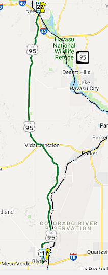 From Route 10 near Blythe to Route 40 near Needles.
 Post 1964 Signage History
This segment is unchanged from its 1963 definition.
 Pre 1964 Signage History
In a letter dated October 4, 1938, the Nevada State Highway Engineer
requested information from the AASHO Executive Secretary pertaining to a
1937 request to extend US 95 through Nevada to Blythe, California.
The origin point for the proposed extension of US 95 was to be the Idaho
Oregon Nevada Highway (I.O.N. Highway #456) at McDermitt at the
Oregon/Neveda state line. The AASHO Executive Secretary replied on
October 8, 1937, indicating that the Oregon Department of Transportation
stated I.O.N. #456 was not ready to facilitate modern automotive
travel. The AASHO Executive Committee's opinion was to hold off on
the extension of US 95 until I.O.N Highway #456 was completed in
Oregon. On May 20, 1939, the Nevada State Highway Engineer again
petitioned the AASHO Executive Committee to extend US 95 through
Nevada. The Nevada State Highway Engineer noted NV 8 had been fully
paved from Winnemucca to the Oregon State Line since 1936 and was ready to
be assigned as US 95 despite I.O.N. Highway #456 not being
completed. The Nevada State Highway Engineer's letter was met with a
reply by the AASHO Executive Secretary on May 24, 1939. The
Executive Secretary stated once notification of the completion of I.O.N.
Highway #456 was received from the Oregon Department of Transportation the
AASHO Executive Committee would likely take action to extend US 95.
(Source: Gribblenation Blog (Tom Fearer), "Interstate 10 in the Sonoran Desert between the Colorado River and Coachella Valley", 10/14/2023)
A letter dated June 2, 1939, from the AASHO Executive Secretary to the
State Highway engineers of; California, Nevada, Oregon and Idaho noted the
proposed alignment of US 95 south to Blythe, California. A separate
letter to the Nevada State Highway Engineer notes that a last-minute
request was made to extend US 93 south of Las Vegas to the California
State Line via Searchlight over NV 5 instead of US 95. A letter
dated June 10, 1939, by the AASHO Executive Secretary to the President of
the AASHO states that the Nevada State Highway Engineer attempted to get
US 95 into Nevada before the completion of I.O.N. Highway #456 under the
pretenses that a like interim measure was permitted for the extension of
US 6 to California. I.O.N Highway #456 was anticipated to be
completed sometime during 1940. The AASHO Executive Secretary
advised the Highway Engineers of California, Nevada, Oregon and Idaho in a
letter dated July 7, 1939, that the AASHO Executive Committee approved the
extension of US 95 to Blythe, California. US 95 absorbed the
existing routing of Sign Route 195/LRN 146 from the Nevada State Line
south to US 60/US 70/LRN 64 at Hobson Way in Blythe. Upon the
extension of US 95 into California the original Sign Route 195 was
deleted. The Sign Route 195 number was reassigned to the former
routing of US 60/US 70 via the spur of LRN 64 in Box Canyon.
(Source: Gribblenation Blog (Tom Fearer), "Interstate 10 in the Sonoran Desert between the Colorado River and Coachella Valley", 10/14/2023)
This route was originally signed as Sign Route 195, and renumbered as US 95 upon the definition of US 95 in the late 1930s (at which point the original 1934 Sign Route 95 (see below) was renumbered as US 395). This segment was LRN 146, defined in 1933.
In 1933, LRN 146 was added with the following definition:
Sign Route 195/LRN 146 entered Blythe via Intake Boulevard and
intersected US 60/US 70/LRN 64 at Hobson Way. Sign Route 195
multiplexed US 60/US 70 west through Blythe and branched south towards the
Imperial County line near Palo Verde via Neighbours Boulevard. In 1937,
AASHO was petitioned to create US 95 from Idaho to Blythe; this was
eventually granted in 1939, and replaced Sign Route 195.
(Source: Gribblenation Blog (Tom Fearer), "US Route 95 in California", 5/20/2023; originally part of "2016 Cross-Country Trip Part 5; Retrospective California State Route 62 and US Route 95", 4/2018)
US 95 was approved to be extended from Blythe to the Mexican border at
San Luis, Arizona, by the AASHO Executive Committee on June 28,
1960. US Route 95 from Intake Boulevard multiplexed US 60/US 70 and
planned I-10 along Hobson Way to the Colorado River and Arizona state
line. The extension of US 95 to the Mexican border was desired by
the Arizona Highway Department and was not objected by the Division of
Highways. US 95 currently multiplexes along I-10 to Quartzite AZ,
and then continues S to Mexico via Yuma AZ.
(Source: Gribblenation Blog (Tom Fearer), "US Route 95 in California", 5/20/2023; originally part of "2016 Cross-Country Trip Part 5; Retrospective California State Route 62 and US Route 95", 4/2018)
In 1961, the new Colorado River Bridge carrying US 60/US 70/US 95/I-10
into Arizona east of Blythe was completed. Construction costs for
the new Colorado River Bridge were shared by the states of California and
Arizona. The new span replaced the earlier 1928 structure.
(Source: Gribblenation Blog (Tom Fearer), "Interstate 10 in the Sonoran Desert between the Colorado River and Coachella Valley", 10/14/2023)
 Status
In June 2012, the CTC approved $272,000 to install median rumble strip to improve safety by reducing crosscenterline collisions on Route 95 from 12 miles south of Havasu Lake Road (~ SBD 25.276) to 9 miles south of Route 40 (~ SBD 48.165).
In January 2018, the CTC amended the following into the SHOPP: 08-SBd-95
40.0/40.4 Route 95 Near Needles, from 2.7 miles to 3.1 miles north of
Havasu Lake Road. Widen shoulders and install ground-in rumble strips.
PA&ED: 4/10/2017 R/W: 2/15/2018 RTL: 6/30/2017 BC: 6/15/2018 Total
Cost: $1,676,000.
(Source: CTC Agenda, January 2018, Agenda Item 2.1a(1))
In March 2013, the CTC approved for future consideration of funding a project in San Bernardino County (08-SBd-95, PM 51.22/51.65) that will realign the vertical profile of US 95, construct two 12-foot lanes with 8-foot shoulders, and restripe the centerline for a no passing zone. The project is programmed in the 2012 State Highway Operation and Protection Program. The total estimated cost is $5,735,000 for capital and support. Construction is estimated to begin in Fiscal Year 2013-14.
 Freeway
[SHC 253.5] Entire portion. Added to the Freeway and Expressway system in 1959.
 From Route 40 west of Needles northerly to the Nevada state line.
Post 1964 Signage HistoryThis segment is unchanged from its 1963 definition.
Arizona 95
 Arizona 95 is one of the few highways from another state that is signed in California. There are
two segments of AZ 95: One runs from US 95 in Quartzsite AZ, N to Parker
AZ, following the Colorado River, finally intersecting I-40. This is shown
on the map for the first segment of US 95 in California. The second
segment (the Mohave Valley Highway) begins at the Colorado River bridge
across from Needles, then goes directly northbound to Bullhead City,
terminating at its junction with AZ 68 north of Bullhead City. There is
also an AZ 95 Truck Route at Parker, formerly a section of AZ 72, connecting to Route 62. Another spur, AZ 95S, exists at Parker Dam, and is signed as a
spur from the mainline but is unmarked along the spur itself.
Arizona 95 is one of the few highways from another state that is signed in California. There are
two segments of AZ 95: One runs from US 95 in Quartzsite AZ, N to Parker
AZ, following the Colorado River, finally intersecting I-40. This is shown
on the map for the first segment of US 95 in California. The second
segment (the Mohave Valley Highway) begins at the Colorado River bridge
across from Needles, then goes directly northbound to Bullhead City,
terminating at its junction with AZ 68 north of Bullhead City. There is
also an AZ 95 Truck Route at Parker, formerly a section of AZ 72, connecting to Route 62. Another spur, AZ 95S, exists at Parker Dam, and is signed as a
spur from the mainline but is unmarked along the spur itself.
(Source: Wikipedia: "Arizona State Route 95"; AARoads "Home » Guides » Arizona » State Route 95")
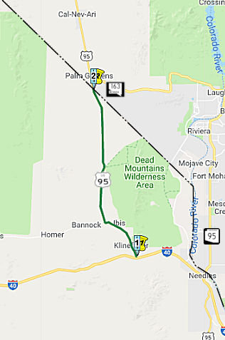
On June 28, 1970, AZ 95 was extended north of I-40/US 66 to AZ 68. The extension of Arizona State Route 95 incorporated
Mohave County 10, Mohave County 1 and Mohave County 227. Mohave
County 10 between Topock and Golden Shores was part of the 1926-1952
alignment of US 66 along Oatman Highway.
(Gribblenation Blog (Tom Fearer), "Arizona State Route 95 Detour in Needles, California", 10/10/2023)
AARoads notes that prior to 1992, AZ 95 was a
continuous route between I-40 at Topock (Exit 1) and Arizona Village. The
highway was decommissioned north through Havasu National Wildlife Refuge
and Fort Mojave Indian Reservation, partially due to right of way issues
at the unincorporated community of Golden Shores. The former route follows
Mojave County 10 (Oatman Highway), Mojave County 1 and Mojave County 233
(Courtwright Road). In 1992, AZ 95 was realigned to begin at the K Street
bridge crossing the Colorado River from Needles, California.
(Source: Wikipedia: "Arizona State Route 95"; AARoads "Home » Guides » Arizona » State Route 95")
Note that the second segment of AZ 95 terminates at the
Colorado River Bridge, with no connecting state highway in California to
bring it back to I-40. To provide continuity of route, AZ 95 is signed in
Needles CA. Cameron Kaiser notes that there is signage along K Street in
California, including a "TO AZ 95" sign and some trailblazers. These signs
were paid for by Arizona DOT and erected by them under permit (with one
exception on I-40—the exit sign for Bullhead City off I-40) are
throughout Needles to show the through route. After 1992 and ADOT's
relinquishment of the old AZ 95 alingment to Mohave County, AZ 95 was
routed into California with the agreement of Caltrans, through Needles and
east along I-40 back over the stateline to rejoin AZ 95 at I-40 exit 9.
(Source: Floodgap Roadgap "US 95 Vegas to Blythe, Part 5: US 95 in Needles, Old US 66, and AZ 95"; AARoads Discussion "AZ 95 in Needles, CA", 6/2023)
The relinquishment of AZ 95 from Mile Marker 211.34 to
227.26 was made formal by resolution on June 19, 1992. The former
routing of AZ 95 north of Needles to Mohave Valley reverted to Mohave
County Routes 10, 1 and 227. The adoption of AZ 95 south of Courtright
Road (Mohave County 227) via Harbor Avenue to the Needles Bridge was made
official by resolution on June 19, 1992. To date the Arizona
Department of Transportation has made no additional attempts to purchase
the right of way of Mohave County Routes 227, 1 and 10.
(Gribblenation Blog (Tom Fearer), "Arizona State Route 95 Detour in Needles, California", 10/10/2023)
In July 2023, it was reported that Bullhead City
leadership was meeting with Arizona Department of Transportation (ADOT)
leaders in Phoenix to continue discussion regarding the proposed transfer
of AZ 95 from state to municipal oversight. The City Council approved
staff proposed pursuit of formal transfer of highway authority through the
Colorado River community during its July 18 2023 meeting. However, an
intergovernmental agreement (IGA) must be approved, spelling out highway
transfer terms. This covers original AZ 95 from MP 227 (where the route
crosses the Colorado at the NE edge of Needles) to MP 250 at AZ 68.
(Source: Havasu News, 7/23/2023)
Pre 1964 Signage HistoryThis route was originally signed as Sign Route 195, and renumbered as US 95 upon the definition of US 95 in the late 1930s (at which point the original 1934 Route 95 (see below) was renumbered as US 395). This segment was LRN 146, defined in 1933.
In 1925, the first US Route System was defined. In the proposal, the
routing points planned for US 91 were clear aside from the southern
terminus in the Mojave Desert of California. In the October 1925
report submitted by the Joint Board on Interstate Highways, US 91 is shown
simply as ending at US 60 (later renumbered as US 66). South of Las Vegas
the routing of the proposed US 91 was at best open to
interpretation. Ultimately, two existing roads south of Las Vegas to
what was planned as US 60 were immediately available; the Los Angeles-Salt
Lake Road towards Daggett or the Arrowhead Trail which was aligned
directly south into California to Bannock (near Needles). The
Arrowhead Trail was multiplexed with the National Park-to-Park Highway and
Evergreen National Highway. As approved in 1926, US 91 was
stated to enter California and end near Needles. Of course, this routing
of US 91 changed. What drove the decision to route US 91 via the Arrowhead
Trail to Daggett appears to be the extension of LRN 31. In 1925 the
Legislature approved an extension of LRN 31 from Barstow to the Nevada
State Line. When LRN 31 became US 91, the other routing was open to become
US 95.
(Source: Gribblenation Blog (Tom Fearer), "US Route 95 in California", 5/20/2023; originally part of "2016 Cross-Country Trip Part 5; Retrospective California State Route 62 and US Route 95", 4/2018)
In 1933, LRN 146 was added with the following definition:
Sign Route 195 multiplexed US 66/LRN 58 from the vicinity of Kleinfelter east to Needles. Within Needles, US 66 and Sign Route 195 multiplexed through the community via Needles Highway, Front Street, G Street and Broadway Street. Sign Route 195 split from US 66 via LRN 146 towards Blythe south of Needles at Parker Junction. In 1937, AASHO was petitioned to create US 95 from Idaho to Blythe; this was eventually granted in 1939, and replaced Sign Route 195.
StatusNeedles Rumble Strips
In May 2018, the CTC approved for future consideration
of funding the following project for which a Negative Declaration (ND) has
been completed: US 95 in San Bernardino County. Construct roadway
improvements including shoulder widening and rumble strip installation on
a portion of US 95 near the city of Needles. (PPNO 399Y) (08-SBd-95, PM
65.4/66.0). This project is located on US 95 near Needles in San
Bernardino County. The project proposes to improve safety by widening
shoulders and installing rumble strips. The project proposes to reduce the
incidence of cross-centerline and run-off road accidents from motorists
drifting from their lane. The proposed project is estimated to cost $1.6
million in capital construction. The project is fully funded and is
currently programmed in the 2018 SHOPP for $4.3 million which includes
Construction (capital and support) and Right-of-Way (capital and support).
The project is estimated to begin construction in FY 2018-19. The scope,
as described for the preferred alternative, is consistent with the project
scope programmed by the Commission in the 2016 SHOPP.
(Source: CTC Agenda, May 2018 Agenda Item 2.2c(1))
In October 2018, the CTC received a report of funding
from the department, on 7/24/2018, of $2,383,000 for the following SHOPP
project: San Bernardino 08-SBd-95 65.4/66.0. US 95 Near Needles, from 1. 4
miles to 2.0 miles north of Goffs Road. Outcome/Output: Widen shoulders
and install ground-in rumble strips. This will reduce the number and
severity of collisions.
(Source: October 2018 CTC Agenda Item 2.5f.(3) Item
10)
In January 2018, it was reported that paper signs placed over the
existing sign that listed emergency contact information and phone numbers
on the "Welcome to California" signs at the border had been removed. The
signs, first noticed by a handful of Twitter users, read "Official
Sanctuary State," and "Felons, Illegals, and MS13 Welcome! Democrats Need
The Votes!" California became a sanctuary state on January 1, 2018,
following a bill signed by Governor Jerry Brown in October. The bill
prevents state law enforcement officers from inquiring about a person's
immigration status, from arresting persons because of civil immigration
warrants, or from participating in a joint task force with federal
officials to enforce immigration laws. The intent is to not discourage
undocumented immigrants from working with law enforcement due to fear that
their cooperation would get them deported. One sign was found and promptly
removed Monday on Interstate 15 near Mountain Pass, just west of the
California-Nevada border. Another was removed from I-40 in the Needles
area near the California-Nevada border. Caltrans has also received
unconfirmed reports of up to three more fake signs — two of which
are reported to be near the Oregon border — but they have not yet
been able to verify the existence of those. The Twitter photo included a
white paddle indicating at least one sign was on Route 95 near Palm
Gardens (the paddle shows "CL", likely referring to Clark County, and the
point where US 95 transitions from California to Nevada).
(Source: SFGate, 1/2/2018; Snopes, 1/2/2018)
Note that there is a parallel AZ 95 on the Arizona side; directional signs near Blythe are provided by Arizona. AZ 95 runs from Needles North. Specifically, the road leading from Topock AZ thru Golden Shores AZ to Courtwright Jct (where it rejoins AZ 95 coming from the Needles bridge) was posted as AZ 95 until the early 90s, ADOT having taken over the road from the county. When ADOT found out that there was not clear title to the right of way (and that the Native landowners wanted some hefty compensation), the road was relinquished back to the county and AZ 95 was rerouted, with ADOT-furnished trailblazing in California from I-40 to the Needles bridge (specifically, all the signs for AZ 95 in Needles were furnished by ADOT; the I-40 signs were installed by Caltrans; and the street signs in Needles were placed by ADOT under permit). However, Caltrans does not permit trailblazing of AZ 95 along I-40 in California, because there is too much potential for confusion with US 95. Caltrans also doesn't officially recognize AZ 95's "hitchhiking" along I-40, but agrees that it's a better route than old AZ 95.
Pre 1964 Signage History The current route of US 95 was
originally signed as Route 195 in the original state signage of routes in
1934. In that definition, Route 195 ran from Palo Verde to Blythe
(present-day Route 78), and from Blythe to the Nevada state line
(present-day US 95). This was all LRN 146.
The current route of US 95 was
originally signed as Route 195 in the original state signage of routes in
1934. In that definition, Route 195 ran from Palo Verde to Blythe
(present-day Route 78), and from Blythe to the Nevada state line
(present-day US 95). This was all LRN 146.
AZ 95 actually predates US 95 in this region. US 95 reached Blythe in 1940, but didn't enter Arizona until 1960, when it took over AZ 95 down to San Luis. AZ 95 was established from San Luis to Yuma in 1936, and extended to Bouse in 1938. In 1954 it was put on a more direct route to Parker, and took over a bit of AZ 72 in the process. It was extended north starting in 1962. It was also constructed south from I-40 in the late 60s, and finally finished between the two by 1970.
 In the original state signage of routes in 1934, Route 95 was
signed along the route from US 66 near Cajon to Route 7 (US 395) near
Little Lake. This was later resigned as US 395, and was LRN 145, defined
in 1933.
In the original state signage of routes in 1934, Route 95 was
signed along the route from US 66 near Cajon to Route 7 (US 395) near
Little Lake. This was later resigned as US 395, and was LRN 145, defined
in 1933.
 Other WWW Links
 Interregional Route
[SHC 164.15] Between Route 10 and the Nevada state line.
 Statistics
Overall statistics for Route 95:
 Pre-1964 Legislative Route
In 1933, the route from "[LRN 23] near Coleville to the California-Nevada state line" was defined as a state highway. This route was codified in 1935 as LRN 95, and retained that routing until the 1963 renumbering. LRN 95 ran from Route 89 near Coleville to the Nevada state line, an was signed as US 395.
© 1996-2020 Daniel P. Faigin.
Maintained by: Daniel P. Faigin
<webmaster@cahighways.org>.
 Route 94
 Route 96