
 California Highways:
Click here for a key to the symbols used. An explanation of acronyms may be found at the bottom of the page.
 Routing
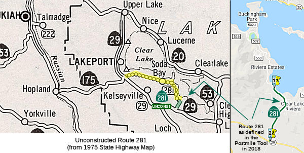 From Route 29 south of Lakeport to Route 29 southerly of Konocti Bay and via the
vicinity of Soda Bay.
From Route 29 south of Lakeport to Route 29 southerly of Konocti Bay and via the
vicinity of Soda Bay.
 Post 1964 Signage History
In 1970, Chapter 1473 defined Route 281 as “Route 29 south of Lakeport to Route 29 southerly of Konocti Bay and via the vicinity of Soda Bay.”
In the Gribblenation Blog "California State Route 281", Tom Fearer notes:
Most Legislative Routes adopted under 1970 Legislative Chapter 1473 were contingent upon a local authority building an existing highway up to State Standards before maintenance would be assumed. Route 281 appears in its current configuration on the 1975 Caltrans Map that suggests that Lake County was only able to fund 3 miles of building Soda Bay Road to State Standards. Soda Bay Road has been around for a significant period of time as it can be seen on the 1917 California Automobile Association Map; it was shown as a minor highway on a 1935 map.
A discussion of the Highways to Boulevards program during the March 2022
CTC meeting identified the following segment(s) as potential Highways to
Boulevards conversion projects: Route 281 in Lake County.
(Source: March 2022 CTC Agenda, Agenda Item 4.3)
 Status
Route 281 has 3 constructed miles that appear in the Caltrans Post Mile
Tool as Post Mile LAK 14.0-17.0 on Soda Bay Road. Soda Bay Road northwest
to CA 29 more or less is the implied connection of CA 281 beyond State
Maintenance. This was improved to a state highway sometime back in the
1990s, as the traversable highways report discussed improvement of the
existing county road to state standards is planned for the distant
future (PM 13.2 through PM 14.0).
(Source: Gribblenation Blog "The Paper Highways north of San Francisco Bay; CA 12, CA 17, CA 37, CA 181, CA 251, and CA 281")
 This routing is unconstructed from 3 mi NW of Route 29 south of
Lakeport to Konocti Bay (Konocti Bay Road), although Soda Bay Road and
County Road 502 appear to cover the route.
This routing is unconstructed from 3 mi NW of Route 29 south of
Lakeport to Konocti Bay (Konocti Bay Road), although Soda Bay Road and
County Road 502 appear to cover the route.
The 2013 Traversable Highways report notes that the segment from Route 29 south of Lakeport to Konocti Bay (14.0 mi) is unconstructed. The closest is Soda Bay Road - Improvement of existing road to state standards is planned for distant future by the county (PM 13.2-14.0).
The SAFETEA-LU act, enacted in August 2005 as the reauthorization of TEA-21, provided the following expenditures on or near this route:
 Other WWW Links
 Statistics
Overall statistics for Route 281:
 Pre-1964 Legislative Route
In 1959, Chapter 1062 defined LRN 281 as “[LRN 2] near the south end of San Diego Bay to east of the United States Naval Auxiliary Air Station, Brown Field”
In 1963, Chapter 1698 changed the east end to LRN 282, but that change was overtaken by the Chapter 385 "great renumbering".
This is Route 117, currently numbered as Route 905 from I-5 near the S end of San Diego Bay to E of Brown Field.
© 1996-2020 Daniel P. Faigin.
Maintained by: Daniel P. Faigin
<webmaster@cahighways.org>.
 Route 280
 Route 282