
 California Highways:
Click here for a key to the symbols used. An explanation of acronyms may be found at the bottom of the page.
 Routing
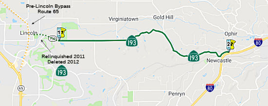 From Route 65 near Lincoln to Route 80 near Newcastle.
 Post 1964 Signage History
This segment remains as defined in 1963.
In 2006, AB 2733, Chapter 362 permitted relinquishment of the portion of Route 193 within the City of Lincoln:
Upon a determination by the commission that it is in the best interests of the state to do so, the commission may, upon terms and conditions approved by it, relinquish to the City of Lincoln the portion of Route 193 that is located within the city limits of that city if the city agrees to accept it. The following conditions shall apply upon relinquishment: (1) The relinquishment shall become effective on the date following the county recorder's recordation of the relinquishment resolution containing the commission's approval of the terms and conditions of the relinquishment. (2) On and after the effective date of the relinquishment, the relinquished portion of Route 193 shall cease to be a state highway. (3) The portion of Route 193 relinquished under this subdivision shall be ineligible for future adoption under Section 81. (4) For the portion of Route 193 relinquished under this subdivision, the City of Lincoln shall apply for approval of a Business Route designation for the relinquished portion of the highway in accordance with Chapter 20, Topic 21, of the Highway Design Manual. (5) For the portion of Route 193 relinquished under this subdivision, the City of Lincoln shall install and maintain within its jurisdiction signs directing motorists to the continuation of Route 193 to the east and to Routes 65 and 80 to the west. Added by AB 2733, September 20, 2006, Chapter 362.
In January 2011, the CTC relinquished right of way in the city of Lincoln on Route 193 (McBean Park Drive and the Lincoln Newcastle Highway) from Route 65 to the easterly city limits, under terms and conditions as stated in the relinquishment agreement dated October 1, 2008, determined to be in the best interest of the State. Authorized by Chapter 362, Statutes of 2006, which amended Section 493 of the Streets and Highways Code.
In 2012, AB 2679 (Chapter 769, 9/29/12) updated the language to reflect the relinquishment:
(b) Upon a determination by the commission that it is in the best interests of the state to do so, the commission may, upon terms and conditions approved by it, relinquish to the City of Lincoln the portion of Route 193 that is located within the city limits of that city if the city agrees to accept it. The following conditions shall apply upon relinquishment:
(1) The relinquishment shall become effective on the date following the county recorder’s recordation of the relinquishment resolution containing the commission’s approval of the terms and conditions of the relinquishment.
(2) On and after the effective date of the relinquishment, the relinquished portion of Route 193 shall cease to be a state highway.
(3) The portion of Route 193 relinquished under this subdivision shall be ineligible for future adoption under Section 81.
(4) For the portion of Route 193 relinquished under this subdivision, the City of Lincoln shall apply for approval of a Business Route designation for the relinquished portion of the highway in accordance with Chapter 20, Topic 21, of the Highway Design Manual.
(5)(b)For theThe relinquished former portion of Route 193relinquished under this subdivision,within the City of Lincoln is not a state highway and is not eligible for adoption under Section 81. For the relinquished former portion of Route 193, the City of Lincoln shall install and maintain within its jurisdiction signs directing motorists to the continuation of Route 193 to the east and to Routes 65 and 80 to thewest.west and shall ensure the continuity of traffic flow on the relinquished portion of Route 193, including any traffic signal progression. The city may apply to the department for approval of a business route designation in accordance with Chapter 20, Topic 21, of the Highway Design Manual.
In 2018, the City of Lincoln grew, adding what was called Village 1. The
history is that Placer County staff was approached by the City of Lincoln
in August 2014 to initiate annexation and tax sharing discussions for the
Lincoln Village 1 Specific Plan development. Lincoln Village 1 is a
1,832-acre Specific Plan area located on the eastern boundary of the City
of Lincoln. The Village 1 Specific Plan is located entirely within
Lincoln's Sphere of Influence. The Specific Plan anticipates the
construction of 5,639 residential units and 167,000 square feet of
commercial/office space, with a mix of country estate units to high
density residential uses spread throughout various villages. The City of
Lincoln proposes to annex approximately 1,712 acres of the Specific Plan
Area. A few parcels on the easterly Specific Plan border near Sierra
College Boulevard are not proposed for annexation at this time by the
City. On May 6, 2015, the City submitted an application to the local
Agency Formation Commission (LAFCo) to formally begin the annexation
process for the Lincoln Village 1 Specific Plan (LAFCo application
#2015-03). This annexation brought the section of Route 193 E of Oak Tree
Lane to Stardust Lane, from the Placer County sphere of interest to the
City of Lincoln sphere of interest. However, it was not covered by the
previous relinquishment legislation or the CTC relinquishment.
(Source: Tax Sharing Agreement between the County of Placer and the City of Lincoln for a portion of the Village 1 Specific Plan Area; Lincoln Planning Department)
As a result, in 2019, AB 1456 (Chapter 629, 10/8/2019) authorized relinquishment of the new segment of Route 193 in the City of Lincoln, adding to the code:
(c) (1) The commission may relinquish to the City of Lincoln the portion of Route 193 that is located within the city limits of the City of Lincoln, upon terms and conditions the commission finds to be in the best interests of the state, if the department and the city enter into an agreement providing for that relinquishment.
(2) A relinquishment under this subdivision shall become effective immediately following the county recorder’s recordation of the relinquishment resolution containing the commission’s approval of the terms and conditions of the relinquishment.
(3) On and after the effective date of the relinquishment, the relinquished portion of Route 193 shall cease to be a state highway.
(4) The portion of Route 193 relinquished under this subdivision shall be ineligible for future adoption under Section 81.
AB 1456 also reduced the signage requirements on the city for the portion previously relinquished:
(b) The relinquished former portion of Route 193 within the City of Lincoln is not a state highway and is not eligible
for adoption under Section 81. For the relinquished former portion
of Route 193, the City of Lincoln shall install and maintain within its
jurisdiction signs directing motorists to the continuation of Route 193
to the east and to Routes 65 and 80 to the west and shall ensure the
continuity of traffic flow on the relinquished portion of Route 193,
including any traffic signal progression. The city may apply to the
department for approval of a business route designation in accordance
with Chapter 20, Topic 21, of the Highway Design Manual.
In March 2020, the CTC again relinquished right of way in the city of
Lincoln (03-Pla-193-PM 1.35/2.57) on Route 193 under the terms and
conditions as stated in the relinquishment agreement dated January 30,
2020, determined to be in the best interest of the State. Authorized
by Chapter 629, Statutes of 2019, which amended Section 493 of the Streets
and Highways Code. This was the section from Oak Tree Lane to the Eastern
city boundary, just E of Stardust Lane.
(Source: March 2020 CTC Agenda, Agenda Item 2.3c)
Regarding this segment (and the discontinuity between the end of this
segment at I-80 and the start of the next segment at Route 49, and the
question of whether there ever was a multiplex along the route) Scott
Parker wrote at AARoads:
(Source: Scott Parker at AARoads, "Re: CA 193", 10/26/2019)
Route 193, at least the section between Lincoln and I-80, has always been a bit of a conundrum; since '64, Caltrans has been a bit schizoid regarding multiplexes; there are no less than 10 signed multiplexes along US 101 -- but relatively few elsewhere in the state. I-80 has seen only three signed multiplexes (I-580, Route 113, and Route 89), at least until the Route 49 reroute in Auburn -- and Route 113 was "silent" for a long time. But Route 193, despite both sections being in the same general area, is one of the oddest routes around -- and one of the few with a back-to-back (implied) multiplex with both Route 49 and I-80. The two segments of the route, currently having different purposes, were given one number back in '64 -- with the understanding that a connector between the two would be a road running along the top of the never-built Auburn Dam, with Route 49 rerouted over the Foresthill and proposed Middle Fork high bridges. There was no implied connection between the two; from the original commissioning to '64 the two sections were two separate LRN's (LRN 91 for Lincoln-Newcastle and LRN 93 for the big "L" through Georgetown).
It's entirely possible that Route 193, even with its "hanging" west end at the Lincoln city line, was considered to be effectively subsumed by the planned Route 102 freeway -- in its second planned iteration away from its original Citrus Heights/Granite Bay alignment. Most plans for that later Route 102 format showed it partially paralleling the western Route 193 east of Lincoln before veering NE to bypass Auburn to the north before terminating at I-80 east of there. If constructed, the Route 102 alignment would have, for all intents and purposes, duplicated the function of the western Route 193. Instead, it was relinquishment in Lincoln that has relegated that Route 193 portion to obscurity -- once the Route 65 west Lincoln bypass was in place -- and Route 193 was truncated back to the east Lincoln city limits -- that the connection between the two routes was effectively severed. In the past, the agency would have reassigned one of the legs -- likely the northern one -- of the original Route 65 alignment through town over to Route 193 and signed it as such, with the interchange between the bypass and the original route serving as Route 193's western terminus. There is a possibility that the new expressway corridor connecting Lincoln with Route 99 (a local project) could be absorbed into the state network as Route 102 -- but unless the agency breaks with current policy and adopts some sort of connector to the remaining state-maintained Route 193 segment, that connecting highway will continue to be effectively "orphaned".
And all observations have been correct -- there never has been a signed Route 193 multiplex over either Route 49 or I-80. State highway maps in the '60's through the '70's showed an unadopted (a row of small circles) Route 193 routing between the east end of the western section near Newcastle and the Route 49/Route 193 junction at Cool, ostensibly over the now-defunct Auburn Dam. Neither Caltrans nor its predecessor Division of Highways ever intended Route 193 to multiplex over the Route 49/I-80 combination between its segment endpoints; but the end of the Auburn Dam plans also marked the severing of the planned connection between those segments.
 Pre 1964 Signage History
This segment was LRN 91. It was defined in 1933. Route 193 was not defined as part of the initial set of state signed routes in 1934.
 In 1963, public hearings were conducted regarding the route for 17 mi of a new US 99E
freeway (future Route 65) near Roseville. The proposed US 99E alternates
extended from I-80 (LRN 3, former US 99E) S of Roseville to a point about
4.5 mi N of Lincoln. They also included a new connection with the
Lincoln-Newcastle highway S of Lincoln (LRN 91, future Route 193). They
also discussed the future location of a portion of LRN 249 (the proposed
freeway routing of Route 65) between Rocky Ridge Road E of Roseville and
I-80 (LRN 17) in Rocklin. There were quite a few routes considered. It
looks like the eventual route chosen was Route D.
In 1963, public hearings were conducted regarding the route for 17 mi of a new US 99E
freeway (future Route 65) near Roseville. The proposed US 99E alternates
extended from I-80 (LRN 3, former US 99E) S of Roseville to a point about
4.5 mi N of Lincoln. They also included a new connection with the
Lincoln-Newcastle highway S of Lincoln (LRN 91, future Route 193). They
also discussed the future location of a portion of LRN 249 (the proposed
freeway routing of Route 65) between Rocky Ridge Road E of Roseville and
I-80 (LRN 17) in Rocklin. There were quite a few routes considered. It
looks like the eventual route chosen was Route D.
(Source: Marysville Appeal Democrat, 11/24/1963 via Joel Windmiller,
1/29/2023)
 In 1964, the State Highway Engineer recommended a routing for the Roseville Bypass, which
also included a segment of Route 193. This was the "X" routing for Route 193, and a combination of the A and K routings for Route 65. The AK
routing leaves I-80 0.3 mi S of the Placer County line, proceeds N for
approx. 4 mi before crossing the existing highway, then continues N about
0.5 mi E of the present route. It recrosses the existing highway 2 mi S of
Lincoln, passing W of the city, and rejoins and runs along the present
alignment from about 1 mi S to 1.3 mi N of Wise Powerhouse Road. The X
routing leaves the recommended route for US 99E (Route 65) SE of Lincoln,
and proceeds E to a junction with the existing highway near the Titan
Missile Site.
In 1964, the State Highway Engineer recommended a routing for the Roseville Bypass, which
also included a segment of Route 193. This was the "X" routing for Route 193, and a combination of the A and K routings for Route 65. The AK
routing leaves I-80 0.3 mi S of the Placer County line, proceeds N for
approx. 4 mi before crossing the existing highway, then continues N about
0.5 mi E of the present route. It recrosses the existing highway 2 mi S of
Lincoln, passing W of the city, and rejoins and runs along the present
alignment from about 1 mi S to 1.3 mi N of Wise Powerhouse Road. The X
routing leaves the recommended route for US 99E (Route 65) SE of Lincoln,
and proceeds E to a junction with the existing highway near the Titan
Missile Site.
(Source: Lincoln News Messenger, 3/26/1964, via Joel Windmiller,
2/26/2023)
 Status
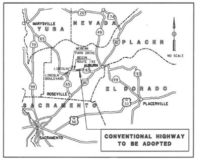 In August 2013, the CTC adopted conventional highway as a
new alignment for Route 193. Route 193 is a traversable highway without an
adopted alignment by the Commission. West of I-80, Route 193 connects the
city of Lincoln and the unincorporated community of Newcastle in Placer
County. East of I-80, Route 193 connects the cities of Auburn and
Placerville. The purpose of this route adoption is to request the
Commission’s approval of this route-alignment as a conventional
highway to allow the Department to construct a curve correction project on
a 1.1 mile segment of Route 193 west of I-80. The segment of the route
that pertains to this route adoption was brought into the State Highway
System in 1935 as LRN 91 and, in 1963 was designated as Route 193. This
portion of Route 193 is not part of the Freeway and Expressway System.
This route began at the intersection of old Route 65 in the city of
Lincoln. In January of 2011, the portion of the route that is located
within city limits was relinquished to the City of Lincoln (from the
intersection with Old Route 65 to the intersection with McBean Park
Drive). This route is a two lane highway and intersects with various
public and private roads within the project limit. It has many operational
deficiencies including tight curves in its alignment, limited sight
distance, short distance tangent between curves, no paved shoulders, and
non-standard super-elevation transitions. There are some paved shoulder
flaring for driveways and intersections that were constructed under
encroachment permit. Corner sight distance at road and driveway
intersections is limited due to both roadway geometry and roadside
vegetation. The existing run off road recoverability for errant vehicles
is limited due to adjacent drainage ditches, embankments and vegetation.
Due to the geometric and operational deficiencies of the roadway, drivers
are not able to adjust their speed in a timely manner causing collisions
through most of the stretch of roadway proposed for realignment and
reconstruction. Currently, to warn drivers to the changes in alignment,
warning signs have been installed and more delineation along the
horizontal curves has been added. This project was initiated by the
Department’s District 3 Traffic Safety Branch in April 2008 after it
was determined that the highway segment from PM 4.6 to PM 5.3 had a high
concentration of run off roads collisions. The preferred alternative
proposes to modify the horizontal alignment using a design speed of 50
mph. This alternative represents a balance of improved safety while
minimizing impacts to adjacent property owners and the environment. The
new alignment will follow fewer horizontal curves with increased radii and
improved sight distance associated with the vertical alignment.
In August 2013, the CTC adopted conventional highway as a
new alignment for Route 193. Route 193 is a traversable highway without an
adopted alignment by the Commission. West of I-80, Route 193 connects the
city of Lincoln and the unincorporated community of Newcastle in Placer
County. East of I-80, Route 193 connects the cities of Auburn and
Placerville. The purpose of this route adoption is to request the
Commission’s approval of this route-alignment as a conventional
highway to allow the Department to construct a curve correction project on
a 1.1 mile segment of Route 193 west of I-80. The segment of the route
that pertains to this route adoption was brought into the State Highway
System in 1935 as LRN 91 and, in 1963 was designated as Route 193. This
portion of Route 193 is not part of the Freeway and Expressway System.
This route began at the intersection of old Route 65 in the city of
Lincoln. In January of 2011, the portion of the route that is located
within city limits was relinquished to the City of Lincoln (from the
intersection with Old Route 65 to the intersection with McBean Park
Drive). This route is a two lane highway and intersects with various
public and private roads within the project limit. It has many operational
deficiencies including tight curves in its alignment, limited sight
distance, short distance tangent between curves, no paved shoulders, and
non-standard super-elevation transitions. There are some paved shoulder
flaring for driveways and intersections that were constructed under
encroachment permit. Corner sight distance at road and driveway
intersections is limited due to both roadway geometry and roadside
vegetation. The existing run off road recoverability for errant vehicles
is limited due to adjacent drainage ditches, embankments and vegetation.
Due to the geometric and operational deficiencies of the roadway, drivers
are not able to adjust their speed in a timely manner causing collisions
through most of the stretch of roadway proposed for realignment and
reconstruction. Currently, to warn drivers to the changes in alignment,
warning signs have been installed and more delineation along the
horizontal curves has been added. This project was initiated by the
Department’s District 3 Traffic Safety Branch in April 2008 after it
was determined that the highway segment from PM 4.6 to PM 5.3 had a high
concentration of run off roads collisions. The preferred alternative
proposes to modify the horizontal alignment using a design speed of 50
mph. This alternative represents a balance of improved safety while
minimizing impacts to adjacent property owners and the environment. The
new alignment will follow fewer horizontal curves with increased radii and
improved sight distance associated with the vertical alignment.
 Freeway
[SHC 253.7] Entire portion. Added to the Freeway and Expressway system in 1959.
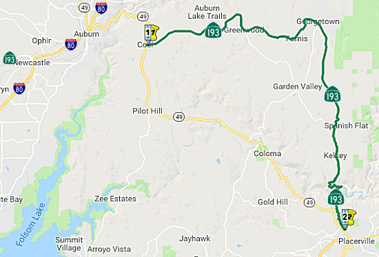 From Route 49 near Cool to Route 49 near Placerville via Georgetown.
Post 1964 Signage HistoryThe current definition of this segment is as defined in 1963 ("(b) Route 49 near Cool to Route 49 near Placerville via Georgetown".... but that wasn't always the case.
In 1972, Chapter 1216 changed the terminus of this segment: "…to Route 49 Route 50 near Placerville via Georgetown." This was
the result of a transfer from Route 49.
In 1984, Chapter 409 revered the transfer, transferring the transferred
portion back to Route 49: "…to Route 50 Route 49 near Placerville via Georgetown."
Pre 1964 Signage HistoryThis route was LRN 93; it was unsigned before 1964. It was defined in 1933.
Note: The portion of Route 49 in Placerville that became part of Route 193 between 1972 and 1988 was part of LRN 65. See Route 49 for the details.
 Naming
 Chappie Memorial Highway") Designates the portion of Route 193 from Route 49 to Cramer Road
in El Dorado County (~ ED 0.154 to ED R1.89) as the "Eugene
“Gene” Chappie Memorial Highway". Named in memory of
Eugene “Gene” Chappie,a long-time El Dorado County resident
and rancher who dedicated his life to serving his county, his state, his
country, and the American people. Chappie was born in March 1920, in
Sacramento. After graduating from high school in 1938, he joined the
United States Army and was promoted to the rank of Captain while serving
in the Pacific Theater during World War II, and later returned to serve
his country again during the Korean War. In 1950, Governor Earl Warren
appointed Gene Chappie to a vacant seat on the El Dorado County Board of
Supervisors, where he served and represented the residents of the 4th
Supervisorial District until he was elected to the State Assembly in 1964,
where he served and represented the residents of the 6th Assembly
District. During his tenure in the Legislature, Gene Chappie served as
Chair of the Welfare Committee from 1967 to 1969, and Chair of the
Assembly Rules Committee from 1969 to 1971. He pioneered legislation in
the area of eliminating architectural barriers for the handicapped, and
authored measures with a more direct bearing on his district, including
legislation regulating the safety and use of snowmobiles and efforts to
introduce planning concepts into the Lake Tahoe basin. Chappie was elected
to the United States House of Representatives in 1980, where he served and
represented the residents of the 1st and 3rd Congressional Districts.
During his six years in Congress, he served on the Agriculture Committee,
the Small Business Committee, the Merchant Marine and Fisheries Committee,
and the Select Committee on Drugs and Narcotics Abuse. He announced his
retirement in 1986 and returned to his family’s ranch in Cool,
California. Governor George Deukmejian appointed Gene Chappie in 1987 to
the California Off-Highway Motor Vehicle Recreation Commission, where he
served until 1992. Governor George Deukmejian then appointed Gene Chappie
in 1988 to a vacant seat on the El Dorado County Board of Supervisors,
returning him once again to represent the constituents of the 4th
Supervisorial District until 1991. Chappie served on various boards and
commissions. President Ronald Reagan appointed him to the federal
Architectural and Transportation Barriers Compliance Board. At the state
level, he served on the Commission on the Status of Women, the Commission
of the Californians, and the Heritage Preservation Commission. Chappie was
a founder of the Mountain Counties Water Resources Association, the
Georgetown Divide Public Utility District, and was one of the original
organizers and supporters of the Jeepers Jamboree. He was a member of the
Rotary Club, the Veterans of Foreign Wars, the American Legion, the Pilot
Hill Grange, the Native Sons of the Golden West, the El Dorado County Farm
Bureau, the Elks, and the Holy Name Society. Gene Chappie passed away on
May 31, 1992, at 72 years of age at his home in Georgetown, California.
Named by Senate Concurrent Resolution (SCR) 2, Res. Chapter 105, Statutes
of 2015, on July 16, 2015.
Designates the portion of Route 193 from Route 49 to Cramer Road
in El Dorado County (~ ED 0.154 to ED R1.89) as the "Eugene
“Gene” Chappie Memorial Highway". Named in memory of
Eugene “Gene” Chappie,a long-time El Dorado County resident
and rancher who dedicated his life to serving his county, his state, his
country, and the American people. Chappie was born in March 1920, in
Sacramento. After graduating from high school in 1938, he joined the
United States Army and was promoted to the rank of Captain while serving
in the Pacific Theater during World War II, and later returned to serve
his country again during the Korean War. In 1950, Governor Earl Warren
appointed Gene Chappie to a vacant seat on the El Dorado County Board of
Supervisors, where he served and represented the residents of the 4th
Supervisorial District until he was elected to the State Assembly in 1964,
where he served and represented the residents of the 6th Assembly
District. During his tenure in the Legislature, Gene Chappie served as
Chair of the Welfare Committee from 1967 to 1969, and Chair of the
Assembly Rules Committee from 1969 to 1971. He pioneered legislation in
the area of eliminating architectural barriers for the handicapped, and
authored measures with a more direct bearing on his district, including
legislation regulating the safety and use of snowmobiles and efforts to
introduce planning concepts into the Lake Tahoe basin. Chappie was elected
to the United States House of Representatives in 1980, where he served and
represented the residents of the 1st and 3rd Congressional Districts.
During his six years in Congress, he served on the Agriculture Committee,
the Small Business Committee, the Merchant Marine and Fisheries Committee,
and the Select Committee on Drugs and Narcotics Abuse. He announced his
retirement in 1986 and returned to his family’s ranch in Cool,
California. Governor George Deukmejian appointed Gene Chappie in 1987 to
the California Off-Highway Motor Vehicle Recreation Commission, where he
served until 1992. Governor George Deukmejian then appointed Gene Chappie
in 1988 to a vacant seat on the El Dorado County Board of Supervisors,
returning him once again to represent the constituents of the 4th
Supervisorial District until 1991. Chappie served on various boards and
commissions. President Ronald Reagan appointed him to the federal
Architectural and Transportation Barriers Compliance Board. At the state
level, he served on the Commission on the Status of Women, the Commission
of the Californians, and the Heritage Preservation Commission. Chappie was
a founder of the Mountain Counties Water Resources Association, the
Georgetown Divide Public Utility District, and was one of the original
organizers and supporters of the Jeepers Jamboree. He was a member of the
Rotary Club, the Veterans of Foreign Wars, the American Legion, the Pilot
Hill Grange, the Native Sons of the Golden West, the El Dorado County Farm
Bureau, the Elks, and the Holy Name Society. Gene Chappie passed away on
May 31, 1992, at 72 years of age at his home in Georgetown, California.
Named by Senate Concurrent Resolution (SCR) 2, Res. Chapter 105, Statutes
of 2015, on July 16, 2015.
(Image sources: Mountain County Water Resources Association)
Pre 1964 Signage HistoryRoute 193 was not defined as part of the initial state signage of routes in 1934. It is unclear what (if any) route was signed as Route 193 between 1934 and 1964.
 Other WWW Links
 Statistics
Overall statistics for Route 193:
 Pre-1964 Legislative Route
In 1933, Chapter 767 added the route from "[LRN 77] near Prado to [LRN 9] near San Bernardino" to the highway system. In 1935, this was added to the highway code as LRN 193, with the definition "[LRN 77] near Prado to [LRN 9] near San Bernardino". Later that year, Chapter 493 changed the route to:
This change truncated both ends of the route. It moved the southern end to the northeast, from roughly the Route 91/Route 71 junction to Route 91/Hamner Av in Corona. The route then ran up Hamner and Milken, originally to US 66 (LRN 9), but that was truncated to US 60 (LRN 19).
In 1959, Chapter 1062 relaxed the routing and extended the route to [LRN 31] near Devore: "[LRN 43] at near Corona northerly
to [LRN 19] [LRN 31] near Devore."
This was the route from present-day Route 91 near Corona to I-215 near Devore. This was the future freeway routing of I-15 (former I-15E). The pre-freeway surface routing of this was former Route 31.
© 1996-2020 Daniel P. Faigin.
Maintained by: Daniel P. Faigin
<webmaster@cahighways.org>.
 Route 192
 Route 194