
 California Highways:
Click here for a key to the symbols used. An explanation of acronyms may be found at the bottom of the page.
 Routing
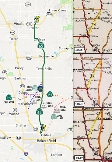 From Route 99 near Bakersfield to Route 198 near Exeter.
 Post 1964 Signage History
This segment remains as defined in 1963.
A planned bypass route for Route 65 around Ducor and Terra Bella first
appears on the 1966 Division of Highways State Map. By 1967 the first
Route 211 (a section of former Route 65) on Famoso-Porterville Highway was
relinquished and what had been Route 211 on Graces Highway was
consolidated into a realigned Route 155. The Ducor-Terra Bella bypass
route of Route 65 is shown to be complete on the 1969 Division of Highways
State Map. This was the last segment of the original Route 65 alignment
between Famoso and Lindsay that was replaced by the current highway. This
in effect removed Road 236 from State Highway service.
(Source: Gribblenation Blog "Old California State Route 65 on; Famoso-Porterville Highway, Sign County Routes J35/J22/J29")
Much of the original Route 65 became segments of the following Sign
County Routes:
(Source: Gribblenation Blog "Old California State Route 65 on; Famoso-Porterville Highway, Sign County Routes J35/J22/J29")
 Pre 1964 Signage History
In 1929, Chapter 767 defined the route from “[LRN 4] near
Bakersfield to Fresno-General Grant National Park Road” as a state
highway (this later became LRN 129). The original southern terminus of LRN 129 met US 99/LRN 4 in Delano. By 1934 the southern terminus of LRN 129
was shifted to Famoso via Famoso-Porterville Highway where it terminated
at US Route 99/LRN 4. In the August 1934 California Highways & Public
Works ("CHPW") guide the Sign State Routes were announced. CA 65 was added
to LRN 129 and terminated in Famoso at US 99/LRN 4.
(Source: Gribblenation Blog "Former US Route 99,US Route 466, and California State Route 65 through Famoso")
The route was designated as LRN 129 in 1933. In 1934, Route 65 was signed along the route from Jct. Route 99 at Famoso to General Grant National Park (now Kings Canyon National Park) via Porterville. This was part of LRN 129, and ran along was is nolw the Famoso-Porterville Highway and Richgrove Drive.
The new Ducor Cut-Off alignment of Route 65/LRN 129 first appears in an
article in the July 1940 CHPW Guide. The Ducor Cut-Off is cited as being
planned to shift Route 65 near the oil farms north of Bakersfield and
shorten the distance of travel to Ducor by 5 miles over the then existing
route on Famoso-Porterville Highway. A portion of the Ducor Cut-Off is
shown to have been completed by July 1940. The Ducor Cut-Off appears as
completed on the 1948 Division of Highways State Map and Route 65/LRN 129
is shown shifted to it off of Famoso-Porterville Highway. The shift of
Route 65/LRN 129 marked the end of State Highway service through the heart
of Famoso.
(Source: Gribblenation Blog "Former US Route 99,US Route 466, and California State Route 65 through Famoso")
As noted above, by 1947, a new routing of LRN 129 was constructed to the E, running from near Oildale to General Grant National park via Porterville, and the Route 65 signage was moved to that routing. As of 1964, the original LRN 129 routing was to be signed Route 211, but that designation was changed in 1965 (although the Richgrove portion became County Sign Route J35).
By 1957 Route 65/LRN 129 was moved onto a bypass of downtown Porterville
which can be seen on the Division of Highways State Map from said year.
This change removed State Highway service from Main Street in Porterville.
(Source: Gribblenation Blog "Old California State Route 65 on; Famoso-Porterville Highway, Sign County Routes J35/J22/J29")
North of Route 198, the original routing for Route 65 ran along present day Route 245 to Route 180. This was all LRN 129, defined in 1933.
The following portions of Route 65 were bypassed by freeway or expressway:
 In 1961, studies of proposed alternate routes for the
Route 65 expressway extension N from Lindsay to the vicinity of Woodlake
were presented. The segment would run from Ave. 228 in Lindsay to Ave 384,
about 4 mi N of Woodlake. Three alternate routes are proposed, all of
which would relocate the present route. There would also be some
adjustments to Route 198 where it intersects the project. The initial plan
is to provide a 4-lane expressway from Lindsay to Route 198 (with the
possibility of an eventual 6-lane freeway). N of Route 198, the plan is
for a 2-lane expressway. Route 198 would get an interchange with Route 65,
and a 4-lane expressway W to tie in with the E city limits of Visalia and
Road 192. Based on the subsequent rescinding of the segment of Route 245
between Route 198 and 1 mi N of Route 201, it looks like proposal 2 was
adopted but never constructed. The portion of the existing Route 65 N of
Route 198 is now Route 245 (nee Route 69)
In 1961, studies of proposed alternate routes for the
Route 65 expressway extension N from Lindsay to the vicinity of Woodlake
were presented. The segment would run from Ave. 228 in Lindsay to Ave 384,
about 4 mi N of Woodlake. Three alternate routes are proposed, all of
which would relocate the present route. There would also be some
adjustments to Route 198 where it intersects the project. The initial plan
is to provide a 4-lane expressway from Lindsay to Route 198 (with the
possibility of an eventual 6-lane freeway). N of Route 198, the plan is
for a 2-lane expressway. Route 198 would get an interchange with Route 65,
and a 4-lane expressway W to tie in with the E city limits of Visalia and
Road 192. Based on the subsequent rescinding of the segment of Route 245
between Route 198 and 1 mi N of Route 201, it looks like proposal 2 was
adopted but never constructed. The portion of the existing Route 65 N of
Route 198 is now Route 245 (nee Route 69)
(Source: Lindsay Gazette, 2/16/1961, via Joel Windmiller, 2/26/2023)
In May 2016, an article in the Modesto Bee noted the original plans for
the route. It pointed out that, driving north from Bakersfield on Route 99, a motorist soon encounters an off-ramp onto Highway 65, which runs up
the east side of the Central Valley – but on to about 70 miles north
of Bakersfield, near the farming town of Exeter. It notes that there is
another segment .200-plus miles further to the north, 35 mile of Route 65
connecting Marysville, north of Sacramento, with Roseville. These were the
hints of what was to be an Eastside Highway, a major north-south route
– a twin, so to speak, of I-5. It’s also evidence of the
slowdown, and then virtual halt, in major highway construction that took
hold in the 1970s as California’s population growth slowed and as
liberal opposition to public works merged with conservative dislike of new
taxes. Projects were abandoned, sometimes with pieces of elevated highway
left dangling. The paperwork of years, even decades, of complex and often
heated local negotiations over routes was filed away.Land acquired for
projects was abandoned or was sold off for other purposes. The northern
section of Route 65 snuck in under the wire. Under intense political
pressure, a young Gov. Jerry Brown authorized its expansion into an
expressway to serve high-tech development. There’s some interest
among San Joaquin Valley officials in rekindling the Route 65 project to
relieve pressure on Route 99, though the source of potential construction
money is, to say the least, problematic. However, Brown’s Department
of Transportation has drafted a new state transportation plan that, in
effect, says California should not add any more carrying capacity into its
roadway system and emphasize mass transit instead.
(Source: Modesto Bee, 5/6/2016)
 Status
Route 99 to Porterville
Widening to Porterville (TCRP Project #114, ~ KER 0.684 to TUL 17.926)
 There are currently plans to widen the segment from Route 65 from 7th Standard Road
to Route 190 in Porterville (~ KER 0.684 to TUL 17.926). This is TCRP
Project #122. This project is to convert Route 65 from an existing
two-lane conventional highway to a four-lane expressway. Originally, this
project was to be coordinated with TCRP Project #114 – Route 65
improvements in Kern County, with a single environmental document for the
entire corridor. However, priorities have changed for both Kern and Tulare
Counties. The scope of TCRP Project #122 is being revised to reflect only
the Tulare County portion of the project (thus, project #122 is now from
the Kern County line). The Kern County portion will be handled under TCRP
Project #114.
There are currently plans to widen the segment from Route 65 from 7th Standard Road
to Route 190 in Porterville (~ KER 0.684 to TUL 17.926). This is TCRP
Project #122. This project is to convert Route 65 from an existing
two-lane conventional highway to a four-lane expressway. Originally, this
project was to be coordinated with TCRP Project #114 – Route 65
improvements in Kern County, with a single environmental document for the
entire corridor. However, priorities have changed for both Kern and Tulare
Counties. The scope of TCRP Project #122 is being revised to reflect only
the Tulare County portion of the project (thus, project #122 is now from
the Kern County line). The Kern County portion will be handled under TCRP
Project #114.
In June 2017, the CTC was informed that TCRP Project 114 is currently inactive. The project had a TCRP allocation of $376,000 for environmental and has a savings of $1,298,000 programmed for the Design phase that was never allocated. Kern COG fully supports the transfer of $1,298,000 TCRP savings to TCRP Project 113 - Route 46 Expressway, Segment 4A.
Terra Bella Expressway - Segment 1 (~ TUL 15.164 to TUL 17.796)
There are also plans to widen near Terra Bella. The August 2004 CTC agenda showed a notice to prepare an EIR to widen to four-lane expressway near Terra Bella. The Draft EIR was reported out in April 2005. Construction of Phase 1 is scheduled to begin in Fiscal Year 2007-08, with Phases 2 and 3 to be constructed as funding becomes available.
In December 2011, the Tulare County Association of Governments (TCAG) updated its Regional Transportation Improvement Program (TIP). The TIP is submitted it to the California Department of Transportation and the California Transportation Commission by March 28 of each year in order for TIP's projects to be included in the state’s TIP funding. The update added a project to widen Route 65 between West Teapot Dome Avenue (Avenue 128) and Route 190, south of Porterville. Construction would start in 2015. The construction costs to widen the road from two to four lanes are estimated at $16.5 million, with $15 million coming from Measure R funds. A state contribution of $1.5 million would cover construction administration costs.
In May 2016, the CTC adjusted the funding to 1,800,000 for Terra Bella Expressway - Segment 1. Near Porterville, on Route 65 from Avenue 120 to 0.3 mile south of Route 190 (~ TUL 15.164 to TUL 17.796). Widen from 2-lane conventional highway to 4-lane expressway.
In May 2017, it was reported that work began in April
2017 on what is being called the Terra Bella Expressway. That
multi-million dollar project will over many years transform Route 65 from
the Kern-Tulare county line to Route 190 into a four-lane expressway.
Currently, work is being done from just south of Tea Pot Dome Avenue to
just south of Route 190 (~ TUL 15.164 to TUL 17.796). Called Segment 1,
work on that should take more than 18 months at a cost of about $25
million. Planned for later on are segments 2, 3 and 4, which will
eventually complete the project to Kern County. Segment 2 is not slated to
begin until 2020 and will be from where the current work ends to Avenue 80
between Ducor and Terra Bella.
(Source: Recorder Online, 5/8/2017)
The 2020 STIP, adopted at the March 2020 CTC meeting,
has programming of $3,370K for R/W closeout on PPNO 8650A Terra Bella
Expressway - Segment 1 (CCA 6/19).
(Source: March 2020 CTC Agenda, Item 4.7, 2020 STIP
Adopted 3/25/2020)
In October 2020, the CTC approved relinquishment of
right of way, consisting of collateral facilities, in the County of Tulare
along Route 65 on Avenue 124, West Teapot Dome Road (Avenue 128), and West
Scranton Avenue (Avenue 136) (06-Tul-65-PM 15.6/17.1, 4 segments). The
County, by Resolution No. 2020-0387 dated June 30, 2020, agreed to waive
the 90-day notice requirement and accept title upon relinquishment by the
State. It also authorized relinquishment of right of way, consisting
of collateral facilities, in the City of Porterville along Route 65 on
West Teapot Dome Road (Avenue 128) and West Scranton Avenue (Avenue 136)
(06-Tul-65-PM 16.1/17.1, 2 segments). The City, by Resolution No.
13-2020 dated March 3, 2020, agreed to waive the 90-day notice requirement
and accept title upon relinquishment by the State.
(Source: October 2020 CTC Agenda, Agenda Item 2.3c)
A small segment, consisting of reconstructed and relocated county roads and frontage roads was up for relinquisment in February 2003, specifically the original routing from PM TUL 21.9 to TUL 29.8 in the County of Tulare (near Linda Vista in North Porterville).
In May 2017, it was reported that work will finally begin on smoothing
Route 65 between Porterville and Lindsay. Five years ago Caltrans did some
work on that highway, but left it with deep groves which are tough on
tires and difficult for small trailers or motorcycles. The contract for
that project has been approved and work on a new pavement overlay all the
way from Olive Avenue in Porterville to Carins Corner on Route 137 (~ TUL
19.066 to TUL 31.583) should begin in June. Estimated cost for that 11.5
miles of new pavement is $13.5 million. The pavement preservation project
for Route 65 was awarded on April 18, 2017 and is currently on schedule to
go into construction on June 1.
(Source: Recorder Online, 5/8/2017)
Route 65 Realignment - Lindsay to Exeter (~ TUL 29.469 to TUL 39.539)
There are also plans to construct a new expressway in Lindsey.
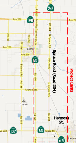 In December 2012,
the CTC reviewed a draft EIR regarding improvements on Route 65 and Route 245 in Tulare County to create the Tulare Expressway. The project will
realign Route 65 and construct a two-lane expressway on a four-lane right
of way for 9.3 miles from Hermosa Street in Lindsay to Avenue 300 on Route 245 northeast of Exeter (~ TUL 29.469 to TUL 39.539, 198 TUL R18.845 to
TUL R19.74, 245 TUL 0.000 to 245 TUL 0.514). There would also be about 0.5
miles of improvements on Route 245 starting at Route 198. The project is
not fully funded. The project is programmed in the 2012 State
Transportation Improvement Program. The total estimated cost for capital
and support is $102,711,000. Construction is estimated to begin in Fiscal
Year 2018-19. In addition to the no-build alternatives, there are two
alternatives being considered: Build Alternative 1 would parallel
the east and west side of existing Spruce Avenue depending on location; Build
Alternative 2 would project the west side of existing Spruce Avenue.
The project is needed to provide a continuous expressway through the
corridor. Existing Route 65 does not provide direct access to Route 245
for traffic wishing to continue NB. Currently NB traffic on Route 65 must
turn E at the Route 65/Route 198 intersection, enter a left turn lane, and
wait for a signal. Route 65 also passes through Exeter, resulting in
traffic flow interruptions with local traffic and the use of Spruce Road
(Road 204) as an alternative. This has increased the accident rate.
In December 2012,
the CTC reviewed a draft EIR regarding improvements on Route 65 and Route 245 in Tulare County to create the Tulare Expressway. The project will
realign Route 65 and construct a two-lane expressway on a four-lane right
of way for 9.3 miles from Hermosa Street in Lindsay to Avenue 300 on Route 245 northeast of Exeter (~ TUL 29.469 to TUL 39.539, 198 TUL R18.845 to
TUL R19.74, 245 TUL 0.000 to 245 TUL 0.514). There would also be about 0.5
miles of improvements on Route 245 starting at Route 198. The project is
not fully funded. The project is programmed in the 2012 State
Transportation Improvement Program. The total estimated cost for capital
and support is $102,711,000. Construction is estimated to begin in Fiscal
Year 2018-19. In addition to the no-build alternatives, there are two
alternatives being considered: Build Alternative 1 would parallel
the east and west side of existing Spruce Avenue depending on location; Build
Alternative 2 would project the west side of existing Spruce Avenue.
The project is needed to provide a continuous expressway through the
corridor. Existing Route 65 does not provide direct access to Route 245
for traffic wishing to continue NB. Currently NB traffic on Route 65 must
turn E at the Route 65/Route 198 intersection, enter a left turn lane, and
wait for a signal. Route 65 also passes through Exeter, resulting in
traffic flow interruptions with local traffic and the use of Spruce Road
(Road 204) as an alternative. This has increased the accident rate.
In November 2016, it was reported that the CTC/Caltrans
had “withdrawn from further consideration” its 2012 plan to
realign Route 65 between Exeter and Lindsay. Project Manager Judy
Aguilar-Luna said the project was being discontinued for a lack of funding
through the State Transportation Improvement Program. Instead Aguilar-Luna
said Caltrans will begin studying “essential improvements”
along the route. She said these will most likely be smaller projects that
can be completed one at a time, such as improving the intersection of
Route 245 and Route 198 near Exeter or changes to the intersections of
Hermosa Street and Oak Avenue along Route 65 in Lindsay. The decision to
stop the project is good news for Lindsay businesses that front the
current alignment of Route 65. Caltrans’ initial plan proposed
realigning Route 65 more closely with Spruce Road (Road 204) and away from
its current route along Road 196 (Kaweah204) and away from its current
route along Road 196 (Kaweah Avenue through Exeter). As part of the
realignment, the current highway would have become a frontage road and the
new highway would have been moved farther west away from the City and
businesses. The City of Lindsay became the first public agency to formally
oppose the Route 65 plan when the City Council approved a letter at its
July 9 meeting over concerns for its highway-adjacent businesses. In the
letter, then City Planner Bill Zigler stated the “awkwardly
configured frontage road” would provide little economic help to the
businesses north of the intersection of Hermosa. The city countered the
plan by proposing a Lindsay exit at Lindmore. The exit would have created
a one-way northbound frontage road along the current highway where it
splits into the new alignment and curves west away from the city. This
would have allowed vehicles to access the affected businesses. North of
Hermosa Street, the frontage road would became two lanes and connect to
the Oak Avenue extension, which was already part of initial project. It
would have also created new opportunities for the City to develop
commercial property that would have faced the new highway. And because
most of the land running along the west side of the current highway
already falls within Lindsay’s urban develop boundaries, the new
highway frontage would have been within the city’s sphere of
influence. The city later withdrew its own proposal after Caltrans said it
would have to condemn all of the properties (both homes and businesses
such as the 76 Station) on the west side of the freeway because Freemont
Drive would have created a dead-end road that exceeded the maximum length
set by the State. Transforming the current highway into a one-way,
northbound “Lindsay Exit” would have required making Fremont
Drive a cul-de-sac at the southern end near Lindmore. There is no
timetable to present the three-phase plan to make improvements along the
route. Once completed, Caltrans will circulate a new draft environmental
document for the replacement project. The draft document will be available
for review at an open forum public hearing and public notice will provided
for new comments.
(Source: Foothills Sun-Gazette, 11/9/2016)
The 2018 STIP, approved at the CTC March 2018 meeting, appears to adjust the allocation for PPNO 0104 Align Rd 204, Rt 65-Rt 198, 4 lanes, TUL 29.5/38.6. Near the city of Tulare, on Route 65 from Lindsay to Exeter, and on Road 204 from Route 137 to Route 198. Widen to 4 divided lanes and realign highway. The 2018 STIP changes the allocation from $3.150M to $5.650M.
The 2020 STIP, approved at the March 2020 CTC meeting,
continues the programming for PPNO 0104 Realignment & Operational
Improvements: $5,650K in prior years. It also adds a new PPNO 0104A
Realign & Op imprvmts (Oak St Roundabout), Phase 1, with programmed
funding of $1,500K in FY23-24.
(Source: March 2020 CTC Agenda, Item 4.7, 2020 STIP
Adopted 3/25/2020)
The December 2011 STIP also includes funding to begin design work in 2015 to widen Route 65 from two to four lanes from Route 137, west of Lindsay, north to Avenue 240 (~ TUL 31.583 to TUL 32.532). State transportation improvement funds would pay more than $1.55 million to cover design work on the 2.5-mile project. TCAG plans to seek funding to widen the entire 13.5-mile stretch of Route 65 between Route 137 and Route 198 (~ TUL 31.583 to TUL 39.536), north of Exeter.
 Naming
Unofficially, "Porterville Highway". Officially, this segment is named the "All America City Highway". This is because the City of Lindsay was awarded "All America City" status by the National Civic League, as have been Bakersfield and Porterville, and all three are linked by Route 65. Named by Assembly Concurrent Resolution No. 47, Chapter 41, in 1996.
 The interchange at Route 65 (06-KER-065 R0.000) and Route 99 (06-KER-099
R29.878) in the County of Kern is named the “Kern County
Sheriff’s Office Deputy Phillip Campas Memorial Interchange”.
It was named in memory of Kern County Sheriff’s Office Deputy
Phillip Campas, who was born in Bakersfield. Campas attended East
Bakersfield High School where he was the starting quarterback and, after
graduating high school, Campas joined the United States Marine Corps.
Campas was deployed to Afghanistan in 2008 as a machine gunner and in
2010, he graduated from a Marine Corps drill instructor school and served
in that capacity for the next three years. Campas was dedicated to the
Marine Corps, and during his service, Campas was awarded the Navy and
Marine Corps Achievement Medal, the Combat Action Ribbon, the Afghanistan
Campaign Medal, the Global War on Terrorism Service Medal, the Marine
Corps Drill Instructor Ribbon, and numerous other medals reflecting
honorably on his military career. In 2015, Campas was honorably discharged
from the Marine Corps, moved his family back to the City of Bakersfield,
and, shortly thereafter, graduated from the Kern County Sheriff’s
Office’s Kern Regional Training Center Academy for peace officers,
where he was the class leader and received the honor of top overall
recruit. In February 2016, Campas was hired by the Kern County
Sheriff’s Office and started his career as a deputy sheriff. Campas
had numerous roles with the Kern County Sheriff’s Office, including
a patrol deputy, special weapons and tactics team (SWAT) operator,
assistant rangemaster, honor guard member, physical training (PT)
instructor, and recruit training officer (RTO). In addition to his duties
at the Kern County Sheriff’s Office, Campas volunteered his time as
an instructor and mentor to the teens involved in the Devil Pups
organization, where he made a lasting impact challenging, educating, and
helping young boys and girls learn self-confidence and responsibility.
Campas served his Kern County community faithfully for five years until
the end of his watch on Sunday, July 25, 2021. On that afternoon, at
approximately 1:00 p.m., deputies from the Kern County Sheriff’s
Office responded to a 911 dispatch reporting that an armed man, the
subject of a restraining order, was at a home near the intersection of 1st
Street and Poplar Avenue in the City of Wasco, and that screaming and
gunfire could be heard in the background of the 911 call. Responding
deputies encountered a woman fleeing the home who stated that at least two
people inside the home had been shot, and the suspect then fired at
deputies and barricaded himself in the home. The Kern County
Sheriff’s Office’s deployed its SWAT team and a standoff
ensued. At approximately 3:00 p.m., the suspect opened fire on members of
the SWAT team as they approached the home, striking Campas and another
deputy, and both deputies were transported to a local hospital where,
tragically, Campas succumbed to his wounds. Named by Senate Resolution SCR 75, Res. Chapter 104, 08/01/22.
The interchange at Route 65 (06-KER-065 R0.000) and Route 99 (06-KER-099
R29.878) in the County of Kern is named the “Kern County
Sheriff’s Office Deputy Phillip Campas Memorial Interchange”.
It was named in memory of Kern County Sheriff’s Office Deputy
Phillip Campas, who was born in Bakersfield. Campas attended East
Bakersfield High School where he was the starting quarterback and, after
graduating high school, Campas joined the United States Marine Corps.
Campas was deployed to Afghanistan in 2008 as a machine gunner and in
2010, he graduated from a Marine Corps drill instructor school and served
in that capacity for the next three years. Campas was dedicated to the
Marine Corps, and during his service, Campas was awarded the Navy and
Marine Corps Achievement Medal, the Combat Action Ribbon, the Afghanistan
Campaign Medal, the Global War on Terrorism Service Medal, the Marine
Corps Drill Instructor Ribbon, and numerous other medals reflecting
honorably on his military career. In 2015, Campas was honorably discharged
from the Marine Corps, moved his family back to the City of Bakersfield,
and, shortly thereafter, graduated from the Kern County Sheriff’s
Office’s Kern Regional Training Center Academy for peace officers,
where he was the class leader and received the honor of top overall
recruit. In February 2016, Campas was hired by the Kern County
Sheriff’s Office and started his career as a deputy sheriff. Campas
had numerous roles with the Kern County Sheriff’s Office, including
a patrol deputy, special weapons and tactics team (SWAT) operator,
assistant rangemaster, honor guard member, physical training (PT)
instructor, and recruit training officer (RTO). In addition to his duties
at the Kern County Sheriff’s Office, Campas volunteered his time as
an instructor and mentor to the teens involved in the Devil Pups
organization, where he made a lasting impact challenging, educating, and
helping young boys and girls learn self-confidence and responsibility.
Campas served his Kern County community faithfully for five years until
the end of his watch on Sunday, July 25, 2021. On that afternoon, at
approximately 1:00 p.m., deputies from the Kern County Sheriff’s
Office responded to a 911 dispatch reporting that an armed man, the
subject of a restraining order, was at a home near the intersection of 1st
Street and Poplar Avenue in the City of Wasco, and that screaming and
gunfire could be heard in the background of the 911 call. Responding
deputies encountered a woman fleeing the home who stated that at least two
people inside the home had been shot, and the suspect then fired at
deputies and barricaded himself in the home. The Kern County
Sheriff’s Office’s deployed its SWAT team and a standoff
ensued. At approximately 3:00 p.m., the suspect opened fire on members of
the SWAT team as they approached the home, striking Campas and another
deputy, and both deputies were transported to a local hospital where,
tragically, Campas succumbed to his wounds. Named by Senate Resolution SCR 75, Res. Chapter 104, 08/01/22.
(Image source: Bakersfield Now)
 The portion of Route 65 in the County of Tulare, between PM TUL 16.130 and PM
TUL 20.880, is named the “Fire Captain Ramon Figueroa and
Firefighter Patrick Jones Memorial Highway”. It was named in
memory of Fire Captain Ramon Figueroa and Firefighter Patrick Jones. Ramon
“Ray” Figueroa, Captain for the Porterville City Fire
Department, was born in January 1985, and received his last alarm on
February 18, 2020, at the young age of 35. Ht was raised in Delano, where
he graduated from Delano High School in 2003, and later attended
Porterville College, at which he completed the Fire Academy and graduated
in 2006. Figueroa began his firefighting career by volunteering with the
Lindsay Fire Department in 2005 until he was hired by the Porterville City
Fire Department as a Firefighter in 2007. After many years of hard work
and training, Firefighter Ray Figueroa was promoted to the rank of Fire
Engineer in 2016, and was promoted to Fire Captain from Lieutenant and
assigned to Station 71 in 2018. Fire Captain Ray Figueroa was part of the
arson investigation unit and was committed to providing prompt, quality
service to the Porterville Community. Patrick Jones, Firefighter for the
Porterville City Fire Department, was born in March 1994, and received his
last alarm on February 18, 2020, at the young age of 25. Jones was raised
in Visalia, California, and graduated from El Diamante High School. Jones
later attended Porterville College, at which he completed the Fire Academy
and worked closer to his dream of becoming a full-time firefighter. Jones
began his firefighting career in 2014 as a Reserve Firefighter for the
City of Porterville, and was hired as a full-time firefighter in 2017.
Jones was relentless when it came to firefighting, and he attended
numerous trainings and received several certifications following his
acceptance of a position with the Porterville City Fire Department. The
two were killed fighting the Porterville library fire in February 2020.
After arriving on the scene, the two were “unable to confirm if all
citizens had been able to exit the building” and rushed in to
search, according to Tulare County Fire Capt. Joanne Bear. A
“mayday” was called after that. Figueroa was found and taken
to a hospital, where he was pronounced dead, Bear said. Jones was
initially reported missing, but his body was later located in the charred
structure. Named by Senate Resolution SCR 14, Resolution Chapter 82, 07/16/21.
The portion of Route 65 in the County of Tulare, between PM TUL 16.130 and PM
TUL 20.880, is named the “Fire Captain Ramon Figueroa and
Firefighter Patrick Jones Memorial Highway”. It was named in
memory of Fire Captain Ramon Figueroa and Firefighter Patrick Jones. Ramon
“Ray” Figueroa, Captain for the Porterville City Fire
Department, was born in January 1985, and received his last alarm on
February 18, 2020, at the young age of 35. Ht was raised in Delano, where
he graduated from Delano High School in 2003, and later attended
Porterville College, at which he completed the Fire Academy and graduated
in 2006. Figueroa began his firefighting career by volunteering with the
Lindsay Fire Department in 2005 until he was hired by the Porterville City
Fire Department as a Firefighter in 2007. After many years of hard work
and training, Firefighter Ray Figueroa was promoted to the rank of Fire
Engineer in 2016, and was promoted to Fire Captain from Lieutenant and
assigned to Station 71 in 2018. Fire Captain Ray Figueroa was part of the
arson investigation unit and was committed to providing prompt, quality
service to the Porterville Community. Patrick Jones, Firefighter for the
Porterville City Fire Department, was born in March 1994, and received his
last alarm on February 18, 2020, at the young age of 25. Jones was raised
in Visalia, California, and graduated from El Diamante High School. Jones
later attended Porterville College, at which he completed the Fire Academy
and worked closer to his dream of becoming a full-time firefighter. Jones
began his firefighting career in 2014 as a Reserve Firefighter for the
City of Porterville, and was hired as a full-time firefighter in 2017.
Jones was relentless when it came to firefighting, and he attended
numerous trainings and received several certifications following his
acceptance of a position with the Porterville City Fire Department. The
two were killed fighting the Porterville library fire in February 2020.
After arriving on the scene, the two were “unable to confirm if all
citizens had been able to exit the building” and rushed in to
search, according to Tulare County Fire Capt. Joanne Bear. A
“mayday” was called after that. Figueroa was found and taken
to a hospital, where he was pronounced dead, Bear said. Jones was
initially reported missing, but his body was later located in the charred
structure. Named by Senate Resolution SCR 14, Resolution Chapter 82, 07/16/21.
(Additional information and image source: LA Times, 2/20/2020)
The portion from Lindsey to Route 198 near Exeter is historically named the "Orange Belt Highway" (~ TUL 28.907 to TUL 39.536) .
 The portion of Route 65 between Route 137 and
Route 198 in Tulare County (~ TUL 31.583 to TUL 39.536) is named the "Detective
Kent Haws Memorial Highway". It was named in memory of Kent Haws,
born on October 1, 1969, in Phoenix, Arizona. On May 28, 1993, Kent Haws
entered the United States Army and became an Airborne Ranger Avenger crew
member assigned to Alpha Battery 3rd Battalion 62nd Air Defense Artillery
Unit, with training in forward area air defense, intelligence handling,
and jungle warfare. He was stationed in Texas and New York, attained the
rank of E4 as a corporal, and was deployed to Haiti. He was an expert
marksman with rifle and grenade and a parachutist, and was awarded over 10
medals, commendations, and ribbons. Upon his honorable discharge from the
United States Army on October 28, 1996, Kent Haws chose to serve his
community by joining the Tulare County Sheriff's Department and working in
various locations, including the Main Jail Detention Facility and the
Porterville Substation, and in the capacities of East Porterville
Community Based Officer, member of both the search and rescue team, and
the Sheriffs' Tactical Enforcement Personnel Unit (STEP). Detective Haws
had a passion for protecting others, and on December 17, 2007, while on
his way home from serving search warrants, he observed a suspicious person
in an orange grove near the town of Ivanhoe and attempted to make contact,
at which time he was fired upon and suffered a fatal injury. He is
remembered by his colleagues in the Tulare County Sheriff's Department as
a "STEP-brother" who led by example, was not afraid to volunteer for the
most difficult of duties, and was a humble leader who understood that true
leadership is characterized by action, not position. Named by Assembly
Concurrent Resolution (ACR) 147, Resolution Chapter 161, on 9/19/2008.
The portion of Route 65 between Route 137 and
Route 198 in Tulare County (~ TUL 31.583 to TUL 39.536) is named the "Detective
Kent Haws Memorial Highway". It was named in memory of Kent Haws,
born on October 1, 1969, in Phoenix, Arizona. On May 28, 1993, Kent Haws
entered the United States Army and became an Airborne Ranger Avenger crew
member assigned to Alpha Battery 3rd Battalion 62nd Air Defense Artillery
Unit, with training in forward area air defense, intelligence handling,
and jungle warfare. He was stationed in Texas and New York, attained the
rank of E4 as a corporal, and was deployed to Haiti. He was an expert
marksman with rifle and grenade and a parachutist, and was awarded over 10
medals, commendations, and ribbons. Upon his honorable discharge from the
United States Army on October 28, 1996, Kent Haws chose to serve his
community by joining the Tulare County Sheriff's Department and working in
various locations, including the Main Jail Detention Facility and the
Porterville Substation, and in the capacities of East Porterville
Community Based Officer, member of both the search and rescue team, and
the Sheriffs' Tactical Enforcement Personnel Unit (STEP). Detective Haws
had a passion for protecting others, and on December 17, 2007, while on
his way home from serving search warrants, he observed a suspicious person
in an orange grove near the town of Ivanhoe and attempted to make contact,
at which time he was fired upon and suffered a fatal injury. He is
remembered by his colleagues in the Tulare County Sheriff's Department as
a "STEP-brother" who led by example, was not afraid to volunteer for the
most difficult of duties, and was a humble leader who understood that true
leadership is characterized by action, not position. Named by Assembly
Concurrent Resolution (ACR) 147, Resolution Chapter 161, on 9/19/2008.
(Image source: Porterville Recorder)
 From Route 198 near Exeter to Route 80 near Roseville on a route along the
easterly side of the San Joaquin Valley, which route may include all or
portions of any existing state highway route.
From Route 198 near Exeter to Route 80 near Roseville on a route along the
easterly side of the San Joaquin Valley, which route may include all or
portions of any existing state highway route.
Post 1964 Signage HistoryAs defined in 1963, this segment was defined as "Route 198 near Exeter to Route 80 near Roseville on a route along the easterly side of the San Joaquín Valley to be selected by the California Highway Commission, which route may include all or portions of any existing state highway route or routes."
Looks familiar, huh?
In 1975, Chapter 244 split this segment and deleted a portion, making the routing "(b) Route 198 near Exeter to Route 104 on a route along the easterly side of the San Joaquín Valley, which route may include all or portions of any existing state highway route. (c) The Sacramento-Placer county line to Route 80 near Roseville."
Why? According to Concrete Bob on AARoads: In November 1974, the
Sacramento County Board of Supervisors voted 3-2 to reject the funding and
construction of Route 65, Route 143 and Route 244. Construction on Route 143 and Route 244 was slated to begin in 1975. When Adriana Gianturco took
over Caltrans in 1975, she worked with Caltrans and the Legislature to
change the routes/abandon them. Sacramento County was very cooperative
with Caltrans on selling off the rights of way for Route 65, Route 143 and
Route 244, since they rescinded the plans for the freeways in November
1974. One of the County Supervisors who voted down the freeways had a
developer brother-in-law who acquired much of the Route 143 right of way
from Caltrans between Arden Way and American River Drive for a housing
development. Twenty years after the plans for the freeways were yanked,
the Sacramento Bee interviewed the County Supervisors who voted down the
freeways. Two of the three supervisors who voted down the freeways
regretted their decision.
(Source: Concrete Bob on AARoads, 7/22/2019)
The 1975 act also noted:
“The department and State Transportation Board shall cooperate with the County of Sacramento and the Sacramento Regional Area Planning Commission in the transportation corridor study conducted by the county and the commission on the adopted route for Route 65. Such cooperation by the state shall be limited to furnishing existing data.
The department shall not, prior to July 1, 1976, or such later date as adopted by the California Highway Commission, dispose of any real property acquired for the construction of Route 65 as a freeway from Route 50 to the Sacramento-Placer county line except for such real property which, as mutually agreed by the department and the county, is not required for any transportation purpose. If, at such a date, the transportation corridor study indicates the other real property is required for any transportation purpose, the department shall not dispose of the real property prior to January 1, 1977.”
In 1985, Chapter 46 brought the definition nearly back to the 1963 routing: "(b) Route 198 near Exeter to Route 80 near Roseville on a route along the easterly side of the San Joaquín Valley, which route may include all or portions of any existing state highway route."
The interchange of US 50 with Sunrise Blvd. is larger than normal, because Sunrise Blvd was, for a short time in the 1970s, designated as Route 65 south of US 50 in anticipation of the freeway routing. This route was relinquished in 1976. On one of the piers for the overcrossing, you can see where it used to call the structure "50/65 separation." The interchange was a cloverleaf until around 2001, when it was converted to a partial cloverleaf.
Pre 1964 Signage History The routing is not determined for the portion from Route 198 to
Route 80. The portion from Route 198 to Route 80 was shown as proposed
both in 1963 and 1986. It was LRN 249, defined in 1959. It appears to have
been Mayhew Road and Gunn Road in the vicinity of Sacramento. Sunrise Blvd
was also at one time planned to be part of Route 65. This was not part of
the original definition of signed Route 65.
The routing is not determined for the portion from Route 198 to
Route 80. The portion from Route 198 to Route 80 was shown as proposed
both in 1963 and 1986. It was LRN 249, defined in 1959. It appears to have
been Mayhew Road and Gunn Road in the vicinity of Sacramento. Sunrise Blvd
was also at one time planned to be part of Route 65. This was not part of
the original definition of signed Route 65.
This whole segment has existed as a "line on a map" since the first
iteration of the master "California Freeway & Expressway System" was
devised in 1959. There was never a formal adoption of alignment for any
portion of this corridor except for a short time in the '70's east of
Sacramento; even that was later rescinded. The only rumblings of anything
being done to advance this corridor came in the early '90's, when eastward
expanding housing in the Fresno/Clovis area prompted some locals to opine
that an eastern bypass of the metro area partially using the Route 65
corridor would be appropriate to address traffic needs. This segment would
have struck out northwest from the Route 65/Route 198 junction as
previously planned, crossing Route 180 just east of Minkler and the San
Joaquin River immediately downstream from Friant Dam. But the
Fresno-initiated plans included intersecting Route 41 a few miles north of
Route 145, and then turning west on another proposed alignment -- an
eastern extension of Route 152, also a longstanding "dotted line" on the
same statewide planning map. The whole thing was envisioned as a large arc
around the eastern side of metro Fresno, providing more immediate egress
from the expanding eastern suburbs. The concept got legs for a while, but
was "back-burnered" by the later part of the decade. Housing in that area
has yet to recover from the recession, so it appears that the corridor is
pretty much shelved.
(Source: Sparker at AAroads, 7/3/2016)
There is no traversable local routing from Route 198 in Tulare County to the Madera-Merced county line touching Route 168. There are no construction plans.
The 2013 Traversable Highways report indicates this is unconstructed:
Sign Route 65 (LRN 129) continue N from Route 198 along the routing that was renumbered in 1964 as Route 69, later renumbered again as Route 245.
 Freeway
 In December 1963, a proposed route adoption was published for a portion of
this segment, between Route 16 and I-80. The Sacramento Bee wrote:
In December 1963, a proposed route adoption was published for a portion of
this segment, between Route 16 and I-80. The Sacramento Bee wrote:
(Source: Joel Windmiller, California's Historic Highways on FB, 6/2/2020)
The state highway commission today announced its intention to adopt routes for proposed freeways in the Fair Oaks area. State Highway Engineer J C Womack was instructed by the commission to determine whether local authorities wish further public hearings on the routes. Previous public meetings developed great controversy among local residents regarding several routes being studied by the highway engineers. The routes that the highway commission has taken under consideration in some cases meet majority local approval and in others have opposition. The routes recommended by Womack for commission: North-south State Highway [Route 65 (LRN 249)] and new Route 244 known as the A alternate offered at the public hearings. This is a line that begins one half mile south of Grant Line Road, and runs north near the westerly boundaries of the Douglas Aircraft and Aerojet-General Corporation properties. It then crosses the American River about a mile upstream from Sunrise Boulevard and runs between Kenneth and Illinois Avenues and continues north to a junction with Rocky Ridge Road east of Roseville in Placer County. This is the direct line route which has received approval of most local agencies except the Fair Oaks Improvement Club. The club suggested routes further to the east. The highway engineers studied these but found them to be less acceptable from the stand-points of traffic service cost area. Combined Route The route is: East-west State Highway LRN 288 (new Route 244) — a line combining parts of what was termed alternates 1 and 4 at previous public hearings beginning at Garfield Avenue near Cypress Avenue in Carmichael that will connect with a freeway routing between Lincoln and Fair Oaks Boulevar to property East of San Juan Ave, then to the American River a little west of Sunrise Boulevard and connecting with the recommended freeway through Fair Oaks. Engineer Womack said there is no intention to construct the freeways at the present time. He estimated it and new roads and bridges across the American River could be eight years away.
Status Unconstructed between Route 198 and I-80. There is currently a
corridor study in progress for the section between Route 198 and Route 152; see http://www.dot.ca.gov/dist6/
for details. There is no local traversable highway along this routing, and
a general routing is not determined.
According to the Fresno Bee, 2001-02-04:
In a major indicator of the tremendous growth projected for California, the state Department of Transportation has begun considering a third north-south highway corridor through the San Joaquin Valley -- a route across the citrus groves and scenic pasture land near the Sierra foothills.
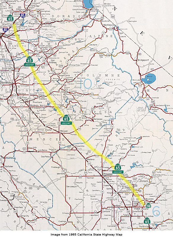
Saying it must plan today for tomorrow's traffic in a state expected to reach a population of 49 million by 2025, Caltrans is studying the possibility of a 54-mile highway from Exeter in Tulare County to Route 152 in Madera County.
The route would stretch existing Route 65, which runs from Bakersfield to Exeter, far to the north across five Sierra rivers and five state highways. It would pass near towns such as Sanger, Orange Cove, Clovis and Friant.
[...]
Caltrans' goal, however, would be to provide relief for the huge increases in traffic projected in years ahead on Highway 99. If the new Highway 65 comes to pass, the state will eventually buy thousands of acres of right-of-way for a route that could, in decades ahead, become a long-haul California freeway.
[...]
Presently, Caltrans is studying only the link from Tulare County to Madera County. Yet the long-range goal is to close a 220-mile gap from Exeter to Rocklin, along I-80 northeast of Sacramento.
Caltrans planners say Highway 65 could begin as a two-lane route or a four-lane expressway, then expand to a foothill freeway. The vision, officials say, is similar to the long-distance I-5 corridor along the Valley's west side with interchanges every few miles.
 According to the Fresno Bee in
early 2007, there were talks about resurrecting this freeway route. A
state-funded master plan for the San Joaquin Valley includes a proposed
north-south highway along the Sierra foothills. The so-called Foothill
Freeway (the Route 65 extension linking Exeter to Chowchilla, which has
existed only on paper since 1959) is being discussed by Fresno and Madera
county planners as a way to ease congestion on Route 99, and to connect
future growth hot spots such as southern Madera County's Rio Mesa area and
Fresno County's Millerton New Town. Caltrans last produced a study six
years ago but set it aside in the face of environmental opposition and
mixed reactions from local government leaders. The proposal is "still
officially inactive" but could be brought back if a consensus emerges from
the current San Joaquin Valley Blueprint effort, in which planners and
other leaders are trying to define a vision for the Valley at midcentury.
Fresno city planners are proposing that Route 65 be part of a beltway
incorporating some form of mass transit as well as highways; this loop
would encircle Madera and the Fresno-Clovis metropolitan area, and would
include land use policies to encourage high-density development on major
transit corridors within the loop while preserving farmland elsewhere.
According to the Fresno Bee in
early 2007, there were talks about resurrecting this freeway route. A
state-funded master plan for the San Joaquin Valley includes a proposed
north-south highway along the Sierra foothills. The so-called Foothill
Freeway (the Route 65 extension linking Exeter to Chowchilla, which has
existed only on paper since 1959) is being discussed by Fresno and Madera
county planners as a way to ease congestion on Route 99, and to connect
future growth hot spots such as southern Madera County's Rio Mesa area and
Fresno County's Millerton New Town. Caltrans last produced a study six
years ago but set it aside in the face of environmental opposition and
mixed reactions from local government leaders. The proposal is "still
officially inactive" but could be brought back if a consensus emerges from
the current San Joaquin Valley Blueprint effort, in which planners and
other leaders are trying to define a vision for the Valley at midcentury.
Fresno city planners are proposing that Route 65 be part of a beltway
incorporating some form of mass transit as well as highways; this loop
would encircle Madera and the Fresno-Clovis metropolitan area, and would
include land use policies to encourage high-density development on major
transit corridors within the loop while preserving farmland elsewhere.
The state's 1959 plan called for Route 65 to extend from its current end north of Exeter in Tulare County to Rocklin in Placer County, northeast of Sacramento. The route was supposed to run north to the east side of Sacramento and on through to I-80 in northeast Roseville. In the Sacramento area, the state brought up much of the right of way in the late 1960s and early 1970s. In November 1974, the Sacramento County Board of Supervisors killed Route 65 (and three other proposed freeways). In 1975, the California Legislature "buried" the plans for 65, but for some reason, resurrected the route in 1986. The 2001 study covered only the area between Exeter and Chowchilla, where the new highway would connect to an eastward extension of Route 152, with no route determination. The 2001 study focused on two wide and largely undeveloped corridors, one on each side of the Friant-Kern Canal near the base of the foothills. Costs at that time were estimated at $671 million or $763 million, depending on the corridor. If the route were revived, a new study would be required to determine an exact route; once approved, the counties and any cities along the route could alter their general plans to preserve needed right of way. However, this requires support of all of the region's local governments.
Note that both the northern and southern ends of Route 65 are currently slated for upgrade. Millions were recently approved from bond funding to build a long-planned and awaited freeway/expressway bypass of Lincoln, CA just north of Roseville (see the next segment of the route for details). To the south, there is a proposal to upgrade Route 65 to a four lane expressway (a.k.a "Terra Bella" Expressway) in Tulare and Kern Counties (see above).
Between 1970 and 1976 Sunrise Blvd. between Route 16 and US 50 was
actually designated as Route 65; there were actually mileposts posted as
such on the road, although no reassurance shields -- or any trailblazer
signage on either of the intersecting highways -- was ever posted. The
Sunrise/US 50 interchange was a full cloverleaf at the time; plans were to
reconstruct Sunrise Blvd. as the intial 2 lanes of an eventual 4-lane
upgradeable expressway. The Sacramento Board of Supervisors voted 3-2 to
kill the Route 65, Route 143, and Route 244 freeways. This happened in
November 1974. Rights of way were acquired for those freeways, and
construction was supposed to begin on portions of Route 143 and Route 244
in 1975. There was a lot of NIMBY-type opposition to the freeways. About
20 years later, the Sacramento Bee published an article where two of the
three supervisors who voted to suspend constuction admitted that they made
a mistake with their vote. The other supervisor had a brother-in-law
developer who bought up a big swath of the Route 143 right of way and
built housing. Most of the mileposts on Route 65 were gone by mid-1977,
but a few near the US 50 interchange (now a parclo) remained until the
mid-80's. Reinstatement of that route was precluded by a redefinition of
Route 65 as ending at Route 104 several miles to the south; there was a
deliberate gap between Route 104 and the Placer County line. Over the
years, both state and local officials have stymied attempts to plan --
much less deploy -- any eastern Sacramento bypass -- and developers
certainly haven't helped, placing housing tracts or commercial facilities
over most of the available land area. Such a bypass is effectively dead as
of now.
(Source: Sparker at AAroads, 8/30/2016; ConcreteBob
at AAroads, 8/30/2016)
Placer County has plans to connect Route 65 to Route 99 with a $200 million to $300 million roadway called Placer Parkway. There are plans for industrial areas on each end of the roadway. There are currently three possible routes that are being reviewed. The northern alternative follows West Sunset Boulevard, and a southern route is near Base Line Road. A third central route cuts through agricultural land between Sunset and Base Line. See Route 102 for more details.
 From Route 80 near Roseville to Route 70 near Marysville.
Post 1964 Signage HistoryAs defined in 1963, this segment ran from "Route 80 near Roseville to Route 70."
In 1970, Chapter 1473 extended this segment to be "Route 80 near Roseville to Route 70 near Marysville" and added segment (d), "Route 70 near Marysville to Route 99 in or near Yuba City."
Roseville Bypass
 In 1963, public hearings were conducted regarding the
route for 17 mi of a new US 99E freeway (future Route 65) near Roseville.
The proposed US 99E alternates extended from I-80 (LRN 3, former US 99E) S
of Roseville to a point about 4.5 mi N of Lincoln. They also included a
new connection with the Lincoln-Newcastle highway S of Lincoln (LRN 91,
future Route 193). They also discussed the future location of a portion of
LRN 249 (the proposed freeway routing of Route 65) between Rocky Ridge
Road E of Roseville and I-80 (LRN 17) in Rocklin. There were quite a few
routes considered. It looks like the eventual route chosen was Route D.
In 1963, public hearings were conducted regarding the
route for 17 mi of a new US 99E freeway (future Route 65) near Roseville.
The proposed US 99E alternates extended from I-80 (LRN 3, former US 99E) S
of Roseville to a point about 4.5 mi N of Lincoln. They also included a
new connection with the Lincoln-Newcastle highway S of Lincoln (LRN 91,
future Route 193). They also discussed the future location of a portion of
LRN 249 (the proposed freeway routing of Route 65) between Rocky Ridge
Road E of Roseville and I-80 (LRN 17) in Rocklin. There were quite a few
routes considered. It looks like the eventual route chosen was Route D.
(Source: Marysville Appeal Democrat, 11/24/1963 via Joel Windmiller,
1/29/2023)
 In 1964, the State Highway Engineer recommended a routing
for the Roseville Bypass, which also included a segment of Route 193. This
was the "X" routing for Route 193, and a combination of the A and K
routings for Route 65. The AK routing leaves I-80 0.3 mi S of the Placer
County line, proceeds N for approx. 4 mi before crossing the existing
highway, then continues N about 0.5 mi E of the present route. It
recrosses the existing highway 2 mi S of Lincoln, passing W of the city,
and rejoins and runs along the present alignment from about 1 mi S to 1.3
mi N of Wise Powerhouse Road. The X routing leaves the recommended route
for US 99E (Route 65) SE of Lincoln, and proceeds E to a junction with the
existing highway near the Titan Missile Site.
In 1964, the State Highway Engineer recommended a routing
for the Roseville Bypass, which also included a segment of Route 193. This
was the "X" routing for Route 193, and a combination of the A and K
routings for Route 65. The AK routing leaves I-80 0.3 mi S of the Placer
County line, proceeds N for approx. 4 mi before crossing the existing
highway, then continues N about 0.5 mi E of the present route. It
recrosses the existing highway 2 mi S of Lincoln, passing W of the city,
and rejoins and runs along the present alignment from about 1 mi S to 1.3
mi N of Wise Powerhouse Road. The X routing leaves the recommended route
for US 99E (Route 65) SE of Lincoln, and proceeds E to a junction with the
existing highway near the Titan Missile Site.
(Source: Lincoln News Messenger, 3/26/1964, via Joel Windmiller,
2/26/2023)
On March 15 1967 the California Highway Commission selected adopted and determined the location of a section of Route 65 north of Roseville along the Roseville bypass alignment. The June 27 1980 motion passed by the California Transportation Commission CTC stated that modification of the State Transportation Improvement Program STIP to include the Roseville Bypass was contingent on several conditions including contribution through dedication of a significant portion of proposed Route 65 right of way.
In 1984, plans were made for a bypass of Roseville that
would move the route off of surface streets. Existing Route 65 at that
time traversed the city streets through the heart of the Roseville
business district The traffic on these city streets was very heavy and
congested during normal peak hours producing serious operational and
safety problems The city of Rocklin also experiences similar traffic
problems along Sunset Boulevard and Taylor Road. This led to the
conclusion that it was not practical to improve existing Route 65 through
Roseville sufficiently to handle even the existing traffic effectively.
There were four alternatives considered:
(Source: Route 65 Roseville Bypass Final EIR)
As a result, the bypass project consisted of approximately 3.7 miles of new highway to be constructed between I-80 northeast of the present Taylor Road Overcrossing and existing Route 65 near Blue Oaks Boulevard. This section of highway is planned to replace the present 5.2 miles of Route 65, which is presently routed through the downtown area of the City of Roseville. Also involved will be the modification of a section of I-80 from 0.6 mile west of Atlantic Street to 1.0 mile east of Taylor Road Overcrossing. Major revisions to the existing East Roseville and Taylor Road Overcrossings are also planned. The new Route 65 will connect to I-80 via a new interchange at a point nearly halfway between Roseville and Rocklin.
A discussion of the Highways to Boulevards program during the March 2022
CTC meeting identified the following segment(s) as potential Highways to
Boulevards conversion projects: Route 65 near Blue Oaks Boulevard (~ PLA
M8.035); Route 65 near Galleria Boulevard (~ PLA R5.926)
(Source: March 2022 CTC Agenda, Agenda Item 4.3)
Pre 1964 Signage HistoryThis segment is signed Route 65, but before 1964, was signed US-99E (and may have been plain US 99 before US 99W was defined). For a while, Route 65 was cosigned with US 99E. Between Route 80 and Route 65, this originally followed the routing of 1964-1994 Route 256. Later, the Route 65 routing was moved to the NE. The route was LRN 3, defined in 1909, between Roseville and Marysville. Parts of this may have been US 40.
StatusRoute 65/I-80 Interchange (~ PLA R5.32 to PLA R6.629)
 In March 2013, the CTC received notice of the preparation of an EIR. This EIR
is for a project that would add High Occupancy Vehicle lanes and
high-speed connections at the I-80/Route 65 Interchange in Placer County.
The project is not fully funded; however, the project is fully funded
through the Project Approval and Environmental Document phase with federal
and local funds. The total estimated cost is $340,000,000 for capital and
support. Construction is estimated to begin in Fiscal Year 2019-20,
depending on the availability of funds. There are five alternatives being
considered: (1) Taylor Road Full Access Interchange (Diamond-Shaped); (2)
Taylor Road Full Access Interchange (Trumpet-Shaped); (3) Taylor Road
Interchange Eliminated; (4) Transportation System Management; and (5)
No-Build (No-Project).
In March 2013, the CTC received notice of the preparation of an EIR. This EIR
is for a project that would add High Occupancy Vehicle lanes and
high-speed connections at the I-80/Route 65 Interchange in Placer County.
The project is not fully funded; however, the project is fully funded
through the Project Approval and Environmental Document phase with federal
and local funds. The total estimated cost is $340,000,000 for capital and
support. Construction is estimated to begin in Fiscal Year 2019-20,
depending on the availability of funds. There are five alternatives being
considered: (1) Taylor Road Full Access Interchange (Diamond-Shaped); (2)
Taylor Road Full Access Interchange (Trumpet-Shaped); (3) Taylor Road
Interchange Eliminated; (4) Transportation System Management; and (5)
No-Build (No-Project).
In December 2016, the CTC approved for future consideration of funding project in Placer County that will construct improvements to the I-80/Route 65 Interchange in the cities of Roseville and Rocklin. The overall project will be constructed in four phases. Phase 1 of this project will construct a northbound auxiliary lane from Route 80 to Galleria Boulevard/Stanford Ranch Road and install a ramp meter on Route 65. Phase 1 is programmed in the 2016 State Highway Operation and Protection Program. The total programmed amount for Phase 1 is $26,650,000 for capital and support. Construction is estimated to begin in Fiscal Year 2017-18. The scope, as described in the Purpose and Need of the environmental document, is consistent with the project scope programmed by the Commission in the 2016 State Highway Operation and Protection Program. Phases 2 through 4 are not fully funded. The total estimated cost for the overall project is $348,000,000 for capital and support.
In August 2017, the CTC approved $3,600,000 from the Budget Act of 2016, Budget Act Item 2660-304-6056 for the following locally administered Proposition 1B TCIF Program project: I-80/Route 65 Interchange Phase 1- Third Lane. In and near Roseville and Rocklin, from 0.4 mile north of Route 80 to 0.5 mile south of the Pleasant Grove Boulevard Overcrossing (~ PLA R5.32 to PLA R6.629). Construct third lane for 1.3 miles. (TCIF 126). The local agency was ready to proceed with this project, and is requesting an allocation at this time. The allocation is contingent upon the approval of a budget revision by the Department of Finance. Future Consideration of Funding approved under Resolution E-16-92; December 2016.
In April 2018, construction was to begin on the Route 80/Route 65 interchange. The first phase will provide a third lane on
northbound Route 65 from I-80 to Pleasant Grove Boulevard and improvements
to the Galleria Boulevard/Stanford Ranch Road interchange. PCTPA and its
partners garnered several funding sources to complete the $50 million
first phase. The I-80 Bottleneck project through Roseville was completed
in 2011 under budget, thus, PCTPA is able to use nearly $10 million
dollars from that project savings. Other local funding sources include
traffic mitigation fees assessed on local developments. The remaining $400
million cost will eventually add one lane to each of the four connectors
between Route 65 and I-80. Future improvements also include maintaining
the existing I-80 access at Taylor Road and eliminating the weaving
movements on I-80 eastbound between Eureka Road and Route 65. However, in
the first phase, the interchange will retain its present configuration as
a trumpet with the heaviest movement around the loop rather than via the
direct SB to EB ramp. The interchange design did not include a reversed
connection to provide a higher-speed connection from I-80 east to Route 65
north. Apparently there was some concern about damage to the adjacent
watershed immediately to the south of the interchange, so the plans were
"massaged" to the present configuration to avoid impinging on the
identified problematic area. Because of funding limitations, a directional
interchange had not been considered, so the area required for the trumpet
had not only needed to be shifted NE along I-80, but also "squeezed" into
a tighter than usual profile so as not to impinge on an adjoining
creekbed; this accounts for the low-speed loop from EB I-80 to NB Route 65. According to Caltrans sources, there's no near-term funded plans to
effect basic changes to the present configuration except to expand
capacity on Route 65 so that the proximity of the regional commercial
center along that freeway to the north of the interchange doesn't result
in additional backup issues around the loop. It does appear that in future
phases, the interchange will become directional.
(Sources: 80/65 Interchange Improvement Project Website, 4/2018; Sparkeron
AAroads, 4/29/2018)
In August 2016, the CTC approved for future consideration of funding a project on Route 65 (03-Pla-65, PM R5.4/R6.4) in Placer County that will modify the Route 65 northbound ramps at the Galleria Boulevard/Stanford Ranch Road interchange and reconfigure lanes along Galleria Boulevard/Stanford Ranch Road in the cities of Roseville and Rocklin. The project is programmed in the 2016 State Highway Operation and Protection Program. The total programmed amount is $21,700,000 for capital and support. Construction is estimated to begin in Fiscal Year 2017-18. The scope, as described for the preferred alternative, is consistent with the project scope programmed by the Commission in the 2016 State Highway Operation and Protection Program.
SR 65 Widening Project (03-Pla-65, PM 6.5/12.8)
In April 2016, it was reported that a small segment of
Route 65 between I-80 and Lincoln Blvd was being repaved. The article also
noted PCTPA's SR 65 Widening Project, which proposes improvements to
relieve congestion, improve operations, and enhance safety to the freeway
from north of Galleria Boulevard/Stanford Ranch Road to Lincoln Boulevard.
These improvements include widening the highway from 2 to 5 lanes in each
direction with mixed-flow lanes and auxiliary lanes between interchanges
to ease the flow of traffic. Currently this project is not funded and
PCTPA, the County of Placer and the cities of Roseville, Rocklin and
Lincoln are exploring strategies to fund this and other critical
transportation projects.
(Source: Rocklin and Roseville Today,4/11/2016)
In May 2018, the CTC approved for future consideration
of funding the following project for which a Mitigated Negative
Declaration (MND) has been completed: Route 65 in Placer County. Widen a
portion of Route 65 in the cities of Roseville, Rocklin, and Lincoln. (EA
1F170) (03-Pla-65, PM 6.5/12.8). This project is located on Route 65 in
the cities of Roseville, Rocklin and Lincoln in Placer County. The project
proposes to widen the existing freeway from north of Galleria
Boulevard/Stanford Ranch Road to Lincoln Boulevard. Carpool/HOV lanes are
also proposed in the project. The project proposes to relieve traffic
operation and safety issues as well as existing mainline congestion by
adding additional capacity. Additional capacity will also accommodate
future growth predictions along this corridor. The proposed project is
currently programmed to cost an estimated $59.3 million and anticipates
funding from the South Placer Regional Transportation Authority. The
project will be built in various phases depending on available funding.
Construction is estimated to begin in FY 2019-20.
(Source: CTC Agenda, May 2018 Agenda Item 2.2c(1))
In August 2016, the CTC authorized relinquishment of right of way in the city of Roseville (City) along Route 65 at Blue Oaks Boulevard (03-Pla-65-PM M8.2), consisting of collateral facilities. The City, by relinquishment agreement dated July 12, 2016, agreed to waive the 90-day notice requirement and accept title upon relinquishment by the State.
The following projects were also planned for this segment:
Lincoln Bypass (~ PLA R12.853 to PLA L23.938)
The following projects were also planned for this segment:
With respect to the Lincoln Bypass, the CTC reviewed in July 2006 the NEIR and had a proposed route adoption. Route 65 is as a major north-south highway along the east side of the Sacramento Valley. It was included as part of the State Highway System under authorization of the State Highway Act of 1909, and was made part of the California Freeway and Expressway system in 1959. The original construction from Roseville to Lincoln, then designated as LRN 3, took place between 1912 and 1914 and was adopted as a freeway by the California Highway Commission on May 20, 1964. Route 65 connects the urbanized areas of Sacramento and Roseville with the cities of Lincoln, Wheatland, Marysville and Yuba City. Route 65 begins in Roseville at I-80 extending to the junction of Route 70 in Yuba County. Legislation was passed in 1985 extending the legislative description of the route to Route 99 in Yuba City. Since the 1964 freeway adoption, there have been considerable changes in land uses along the existing alignment from Roseville through Lincoln. Once primarily agricultural in nature, the past thirty years has seen a shift to industrial, residential, and commercial land uses within the corridor. The city of Lincoln, recognizing the considerable changes in land use along this corridor, requested the Commission consider approving a modification to the current adopted alignment on March 24, 1987. This project is one of several transportation projects responding to the growth in the area. Continued growth in south Placer County and the Sacramento Valley has resulted in the need for a new and improved Route 65 corridor, which would alleviate congestion in the city of Lincoln while providing for improved inter-regional traffic flow. The existing facility as of 2006 through Lincoln is a “Main Street” highway, which will not serve the ultimate transportation needs of the region. As traffic volumes continued to increase, Route 65 within downtown and south of the city of Lincoln has exceeded available capacity. The existing road between the city of Lincoln and town of Sheridan is a two-lane conventional highway. Right of way in this vicinity is typically 100-110 feet (30.5 to 33.5 meters) wide. Between the city of Lincoln and the town of Sheridan, there are two passing opportunity locations; each approximately 1.5 miles (2.4 kilometers). Curves and left-turn channelization along this section of highway limit passing opportunities. From the town of Sheridan north, the route continues as a two-lane conventional highway, passing through the town of Wheatland, slowing down traffic to 35 mph. Three miles north of the town of Wheatland, the highway becomes a four-lane freeway and terminates at the Route 99 in Yuba City.
 Caltrans prepared a Project Study Report for the Lincoln bypass in July 1987 that analyzed 16
alternatives. The Draft Project Report was approved on November 5, 2002,
and analyzed a no build alternative and six viable alternatives. On May
17, 2006, the Project Report was approved recommending the preferred
alternative as depicted on the attached route adoption map. This project
will allow for the identification and preservation of a new corridor for
the eventual staged construction of a four-lane freeway with interchanges
at selected locations and the ultimate relinquishment of a portion of the
existing Route 65 to the city of Lincoln and Placer County. The project
begins near the junction of Industrial Avenue and Route 65 just south of
the city of Lincoln (~ PLA R12.853) and extends to the Bear River, just
north of the town of Sheridan (~ PLA L23.938). The Lincoln Bypass project
will provide a substantial benefit in accommodating regional traffic and
helping to relieve congestion and improve safety on existing Route 65
through the city of Lincoln. Without the bypass, future traffic congestion
will create gridlock conditions within and surrounding the city of
Lincoln. The bypass will accommodate projected traffic volumes through the
year 2025. The Lincoln Bypass project consists of a four-lane freeway and
two-lane expressway and includes right-of-way acquisition for an ultimate
freeway. This project will include four lanes from just south of
Industrial Avenue to just north of North Ingram Slough. From north of
North Ingram Slough, the project will include two lanes up to the northern
tie-in with existing Route 65 near the town of Sheridan. Industrial Avenue
will be a partial interchange and the proposed Ferrari Ranch Road will be
an undercrossing. At-grade intersections will be constructed at Nelson
Lane, Wise Road and Riosa Road. This project has an overcrossing structure
at Nicolaus Road and an overcrossing at UPRR/Industrial Avenue. As funding
becomes available, the ultimate facility will include extending the
four-lane configuration northward from North Ingram Slough to the town of
Sheridan. The project is currently programmed for $262,334,000 for support
and capital costs in the 2006 State Transportation Improvement Plan. The
Department and local partners are financing this project jointly. Advisory
and Mandatory Design Exceptions were approved on September 6, 2002. The
Department approved the Project Report on May 17, 2006. An Environmental
Impact Report and Environmental Impact Statement was completed in
conformance with the California Environmental Quality Act (CEQA) and the
National Environmental Policy Act (NEPA). The adoption of the Lincoln
Bypass will create a break in system continuity for Route 193. There are
discussions with the city of Lincoln for the “legislative
relinquishment” of Route 193 within its’ jurisdiction. [See AB
2733, 2005-2006] To maintain system continuity, the legislation proposes
that the city of Lincoln install and maintain signs directing motorists to
the continuation of Route 193 to the east and Route 65 and I-80 to the
west. The city of Lincoln is required to apply for approval of a Business
Route designation for that portion of the relinquished highway. The city
of Lincoln has also agreed to install and maintain signs for the traveling
public when Ferrari Ranch Road is designated as the main arterial route
between Route 65 and the continuation of Route 193. The relinquishment
cooperative agreement will convey the same continuity message. A Freeway
Agreement will be developed and executed with the city of Lincoln and the
county of Placer after Commission approval of the route adoption.
Caltrans prepared a Project Study Report for the Lincoln bypass in July 1987 that analyzed 16
alternatives. The Draft Project Report was approved on November 5, 2002,
and analyzed a no build alternative and six viable alternatives. On May
17, 2006, the Project Report was approved recommending the preferred
alternative as depicted on the attached route adoption map. This project
will allow for the identification and preservation of a new corridor for
the eventual staged construction of a four-lane freeway with interchanges
at selected locations and the ultimate relinquishment of a portion of the
existing Route 65 to the city of Lincoln and Placer County. The project
begins near the junction of Industrial Avenue and Route 65 just south of
the city of Lincoln (~ PLA R12.853) and extends to the Bear River, just
north of the town of Sheridan (~ PLA L23.938). The Lincoln Bypass project
will provide a substantial benefit in accommodating regional traffic and
helping to relieve congestion and improve safety on existing Route 65
through the city of Lincoln. Without the bypass, future traffic congestion
will create gridlock conditions within and surrounding the city of
Lincoln. The bypass will accommodate projected traffic volumes through the
year 2025. The Lincoln Bypass project consists of a four-lane freeway and
two-lane expressway and includes right-of-way acquisition for an ultimate
freeway. This project will include four lanes from just south of
Industrial Avenue to just north of North Ingram Slough. From north of
North Ingram Slough, the project will include two lanes up to the northern
tie-in with existing Route 65 near the town of Sheridan. Industrial Avenue
will be a partial interchange and the proposed Ferrari Ranch Road will be
an undercrossing. At-grade intersections will be constructed at Nelson
Lane, Wise Road and Riosa Road. This project has an overcrossing structure
at Nicolaus Road and an overcrossing at UPRR/Industrial Avenue. As funding
becomes available, the ultimate facility will include extending the
four-lane configuration northward from North Ingram Slough to the town of
Sheridan. The project is currently programmed for $262,334,000 for support
and capital costs in the 2006 State Transportation Improvement Plan. The
Department and local partners are financing this project jointly. Advisory
and Mandatory Design Exceptions were approved on September 6, 2002. The
Department approved the Project Report on May 17, 2006. An Environmental
Impact Report and Environmental Impact Statement was completed in
conformance with the California Environmental Quality Act (CEQA) and the
National Environmental Policy Act (NEPA). The adoption of the Lincoln
Bypass will create a break in system continuity for Route 193. There are
discussions with the city of Lincoln for the “legislative
relinquishment” of Route 193 within its’ jurisdiction. [See AB
2733, 2005-2006] To maintain system continuity, the legislation proposes
that the city of Lincoln install and maintain signs directing motorists to
the continuation of Route 193 to the east and Route 65 and I-80 to the
west. The city of Lincoln is required to apply for approval of a Business
Route designation for that portion of the relinquished highway. The city
of Lincoln has also agreed to install and maintain signs for the traveling
public when Ferrari Ranch Road is designated as the main arterial route
between Route 65 and the continuation of Route 193. The relinquishment
cooperative agreement will convey the same continuity message. A Freeway
Agreement will be developed and executed with the city of Lincoln and the
county of Placer after Commission approval of the route adoption.
The SAFETEA-LU act, enacted in August 2005 as the reauthorization of TEA-21, provided the following expenditures on or near this route:
In 2007, the CTC recommended $73.715M in funding from the Corridor Mobility Improvement Account (CMIA) for the Lincoln Bypass.
In July 2008, the $325 million Route 65 bypass in Lincoln broke ground. Scheduled for completion in 2013, the nearly 12-mile roadway will stretch from Industrial Boulevard west around the city of Lincoln and link back to Route 65 near Sheridan. The intent is to divert commuters and big rigs away from Lincoln's downtown area, where traffic comes to a standstill during morning and evening rush hours. Placer County officials adopted the idea of a bypass in the 1973 general plan, and by 1988 growth in the region prompted the state to allocate the first dollars for the project. But the funds were diverted to pay for seismic retrofit projects after the Loma Prieta earthquake hit the Bay Area in 1989 and again when the Northridge quake struck Los Angeles in 1994. It wasn't until the late 1990s that local officials renewed efforts to build the bypass. Back then, the estimated cost was $50 million. The project also had to endure a lengthy environmental review since the new roadway cuts through farmland and sensitive wildlife habitat.
In August 2009, the CTC approved an amendment to the CMIA baseline agreement for the Route 65 Lincoln Bypass project to extend the four-lane portion of the project by 1.5 miles. The Department will negotiate with the contractor to execute a contract change order (CCO) that creates minimal risk to the completion of the contract within the existing contract allotment and schedule. The ultimate scope of the Lincoln Bypass project will consist of a four-lane expressway on a new alignment from south of Lincoln at Industrial Boulevard to near Riosa Road, north of Lincoln. Due to rapid escalation of the construction cost estimate, the project was staged to initially construct a four-lane facility for approximately four miles at the southern end of the project and a two-lane facility for the remaining eight miles. The funding approved in the CMIA baseline agreement was assumed to be sufficient for this initial stage. The project has been in construction since 2008 and is approximately 20 percent complete as of July 2009. The majority of the right of way work is complete and other significant risks have not materialized. The current supplemental funds and contingency balance is $18 million. This is about $5.5 million more than needed to complete the contract which can be used to fund the additional work. Even with the added work, the project will still maintain the standard 5 percent contingency balance. The contractor has indicated a willingness to perform the additional work at the unit prices of the original contract. Completing this work under CCO now can be accomplished at a much lower cost as compared to a separate contract awarded at a later date.
In June 2010, it was reported that Caltrans is well into building an 11-mile highway to the west of Lincoln that will bypass downtown Lincoln. Opening day is slated for sometime in 2012, and could knock G Street traffic from 31,000 vehicles a day down to 18,000. When the bypass opens, the state will decommission the old highway and turn ownership of G Street over to Lincoln.
In June 2011, it was reported that some traffic shifts were occuring to prepare for connection to the new Lincoln Bypass.
 In September 2011, the CTC received a request to amend the CMIA baseline
agreement for the Lincoln Bypass project - Phase 1 (PPNO 0145M) to add
scope to included the Lincoln Bypass - Phase 2A (PPNO 4895) project, which
extends the four-lane expressway from Nelson Lane to West Wise Road, and
to update the funding plan and delivery schedule. At the June 2011
meeting, the Commission approved Resolution CMIA-P-1011-07, which added an
additional $20,000,000 in CMIA funding for new scope, now referred to as
the Lincoln Bypass project -Phase 2A (PPNO 4895); which will extend the
four-lane expressway from Nelson Lane to West Wise Road. The funding for
Phase 2A includes $2,999,000 in local funds.
In September 2011, the CTC received a request to amend the CMIA baseline
agreement for the Lincoln Bypass project - Phase 1 (PPNO 0145M) to add
scope to included the Lincoln Bypass - Phase 2A (PPNO 4895) project, which
extends the four-lane expressway from Nelson Lane to West Wise Road, and
to update the funding plan and delivery schedule. At the June 2011
meeting, the Commission approved Resolution CMIA-P-1011-07, which added an
additional $20,000,000 in CMIA funding for new scope, now referred to as
the Lincoln Bypass project -Phase 2A (PPNO 4895); which will extend the
four-lane expressway from Nelson Lane to West Wise Road. The funding for
Phase 2A includes $2,999,000 in local funds.
In Spring 2012, Caltrans put the Lincoln Bypass project out for bid, looking for a contractor to construct southbound lanes in Placer County near Lincoln from 2.6 miles north of Twelve Bridges overcrossing to 5.1 miles south of the Bear River Bridge.
In September 2012, the CTC revised the project description to construct two additional southbound lanes from Nelson Lane to 0.9 miles north of West Wise Road. They also updated the project funding plan to add $100,000 of local funds to address an increase to the design phase, and redistributed $500,000 to construction support to address unaccounted workload and other costs.
In October 2012, it was reported that the Lincoln Bypass Phase I project was completed and opened. The $325 million, 11-mile, Route 65 bypass, looping west of Lincoln in Placer County, gives commuters a quicker ride from Yuba City and Marysville to I-80, and clears up the congestion in downtown Lincoln.
In May 2014, the CTC authorized relinquishment of right of way in the city of Lincoln on Route 65 (Lincoln Boulevard) between realigned Route 65 (Lincoln Bypass) and the northerly city limits, consisting of superseded highway right of way. The City, by cooperative agreement dated February 14, 2008, waived the 90-day notice requirement and agreed to accept title upon relinquishment by the State. It also authorized relinquishment of right of way in the county of Placer on Route 65 (Lincoln Boulevard) between the northerly city limits and realigned Route 65 (Lincoln Bypass) consisting of superseded highway right of way, and along realigned Route 65 (Lincoln Bypass), consisting of collateral facilities. The County, by cooperative agreement dated February 19, 2008 and by letter dated October 8, 2013, waived the 90-day notice requirement and agreed to accept title upon relinquishment by the State. The bypassed highway is now called "Old Highway 65".
The following projects were also planned for this segment:
In March 2013, the CTC approved for future consideration of funding a project in Yuba County will perform scour mitigation at Dry Creek Bridge (Bridge 16-0002, YUB 002.21) on Route 65 near Wheatland, placing rock slope protection under the bridge and replacing a deck on the roadway with concrete deck overlay. The project is programmed in the 2012 State Highway Operation and Protection Program. The total estimated cost is $4,503,000 for capital and support. Construction is estimated to begin in Fiscal Year 2013-14.
 Business Routes
The portion of former Route 256 is likely signed as Business Route 65 in Roseville.
Naming Johnson Expressway") A short segment of this route just N of Route 80 is named the "Harold "Bizz"
Johnson Expressway" (~ PLA R4.938 to PLA M8.065). It was named by
Assembly Concurrent Resolution 92, Chapter 88, in 1986. Congressman Harold
T. "Bizz" Johnson, state Senator from 1949 to 1958, who served in the
House of Representatives from 1958-1980, was instrumental in helping
establish the Rails-to-Trails program. He also promoted water development
projects and sided with consumer-owned electric utilities against the
economic and political clout of big investor-owned systems like Pacific
Gas and Electric Co. He also successfully broadened language in the
Surface Transportation Assistance Act to allow bridges over highways,
railroads and other physical features to qualify for funding under the
Act's bridge replacement provisions.
A short segment of this route just N of Route 80 is named the "Harold "Bizz"
Johnson Expressway" (~ PLA R4.938 to PLA M8.065). It was named by
Assembly Concurrent Resolution 92, Chapter 88, in 1986. Congressman Harold
T. "Bizz" Johnson, state Senator from 1949 to 1958, who served in the
House of Representatives from 1958-1980, was instrumental in helping
establish the Rails-to-Trails program. He also promoted water development
projects and sided with consumer-owned electric utilities against the
economic and political clout of big investor-owned systems like Pacific
Gas and Electric Co. He also successfully broadened language in the
Surface Transportation Assistance Act to allow bridges over highways,
railroads and other physical features to qualify for funding under the
Act's bridge replacement provisions.
(Image sources: 365 Things to Do in Roseville; Wikipedia)
 The interchange of Stanford Ranch Road and Galleria Boulevard on Route 65 just N of I-80
(~PLA R5.929) is named the "Officer Matthew J. Redding Memorial
Interchange". This segment was named in memory of Officer Matthew J.
"Matt" Redding, a decorated police officer, was killed in the line of duty
by a drunk driver on October 9, 2005 on Route 65 near the interchange of
Stanford Ranch Road and Galleria Boulevard while serving the community and
protecting his fellow officers. Redding grew up in Rocklin, graduated from
Del Oro High School, attended Sierra College, and had a strong desire to
become a police officer. He was hired by the City of Rocklin as a police
officer on December 10, 2001, and was a highly respected police officer
who, in under four years, was selected to serve on the Regional SWAT team
and decorated for valor, life saving, and meritorious duty. Named by
Senate Concurrent Resolution (SCR) 10, Resolution Chapter 84, on
7/10/2007.
The interchange of Stanford Ranch Road and Galleria Boulevard on Route 65 just N of I-80
(~PLA R5.929) is named the "Officer Matthew J. Redding Memorial
Interchange". This segment was named in memory of Officer Matthew J.
"Matt" Redding, a decorated police officer, was killed in the line of duty
by a drunk driver on October 9, 2005 on Route 65 near the interchange of
Stanford Ranch Road and Galleria Boulevard while serving the community and
protecting his fellow officers. Redding grew up in Rocklin, graduated from
Del Oro High School, attended Sierra College, and had a strong desire to
become a police officer. He was hired by the City of Rocklin as a police
officer on December 10, 2001, and was a highly respected police officer
who, in under four years, was selected to serve on the Regional SWAT team
and decorated for valor, life saving, and meritorious duty. Named by
Senate Concurrent Resolution (SCR) 10, Resolution Chapter 84, on
7/10/2007.
(Image source: Rocklin: In The Line of Duty)
 The portion of Route 65 between
the intersection with Sunset Boulevard (approx PLA-065-R9.549) and the
intersection with Route 193 (since relinquished -- it was Lincoln Blvd and
McBean Parkway in Lincoln, so presumably this is now where Lincoln (old
65) exits the Lincoln Bypass, Industrial Ave, PLA-065-R12.866) in Placer
County is named the Officer Mark A. White Memorial Highway. It was
named in memory of Roseville Police Officer Mark A. White, a dedicated
officer, who was killed in the line of duty on Friday, February 10, 1995,
when he was fatally shot during a hostage situation. At Officer White's
funeral, the procession was estimated to be over nine miles long. Officers
and other mourners came from all over the State of California, and some
attended from as far away as Nebraska and Ohio. Officer White was
remembered as a happy, warm, compassionate officer, who had a zest for
life, a dedicated father and a loving husband. He was a highly respected,
dedicated officer for over nine years, first serving in Sutter County as a
Deputy Sheriff for five years, then in Roseville as a Police Officer for
four years. While serving in Sutter County, Officer White was a member of
the S.E.D. team and a diver with the search and rescue team. While serving
in Roseville, Officer White was the neighborhood officer, he worked
hand-in-hand with community members cleaning up the streets and making it
a safer place for everyone. The highway was named to remind us of the
ultimate sacrifice Officer White made on that cold, wet February
afternoon, as well as remind us of the sacrifices peace officers make on a
daily basis. Named by Assembly Concurrent Resolution 179, July 16, 2004,
Chapter 126.
The portion of Route 65 between
the intersection with Sunset Boulevard (approx PLA-065-R9.549) and the
intersection with Route 193 (since relinquished -- it was Lincoln Blvd and
McBean Parkway in Lincoln, so presumably this is now where Lincoln (old
65) exits the Lincoln Bypass, Industrial Ave, PLA-065-R12.866) in Placer
County is named the Officer Mark A. White Memorial Highway. It was
named in memory of Roseville Police Officer Mark A. White, a dedicated
officer, who was killed in the line of duty on Friday, February 10, 1995,
when he was fatally shot during a hostage situation. At Officer White's
funeral, the procession was estimated to be over nine miles long. Officers
and other mourners came from all over the State of California, and some
attended from as far away as Nebraska and Ohio. Officer White was
remembered as a happy, warm, compassionate officer, who had a zest for
life, a dedicated father and a loving husband. He was a highly respected,
dedicated officer for over nine years, first serving in Sutter County as a
Deputy Sheriff for five years, then in Roseville as a Police Officer for
four years. While serving in Sutter County, Officer White was a member of
the S.E.D. team and a diver with the search and rescue team. While serving
in Roseville, Officer White was the neighborhood officer, he worked
hand-in-hand with community members cleaning up the streets and making it
a safer place for everyone. The highway was named to remind us of the
ultimate sacrifice Officer White made on that cold, wet February
afternoon, as well as remind us of the sacrifices peace officers make on a
daily basis. Named by Assembly Concurrent Resolution 179, July 16, 2004,
Chapter 126.
(Image source: Officer Down Memorial Page)
 The portion of the Rout 65 Lincoln Highway in the County of Placer from Lincoln Boulevard (postmile PLA-065-R12.87) to Nelson Lane (postmile PLA-065-R15.55) is
named the "Thomas J. Cosgrove Memorial Highway". It was named in
memory of Thomas Joseph Cosgrove, who was born in November 1948, and moved
to the City of Lincoln in the County of Placer in 1987. Ever since that
time he remained dedicated to making Lincoln a better place to live by
serving as a volunteer firefighter for many years prior to the city
adopting a full-time fire department and by serving on the city council
and other local organizations. Tom Cosgrove was first elected to the City
Council of the City of Lincoln in 1994, at which time the city had a
population of 8,304 people and one traffic light at the intersection of
Route 193 and Route 65. He served 18 years as a city council member and
served as Mayor of the City of Lincoln in 1997, 2001, 2005, and 2010. In
his 18 years as a city council member, Tom Cosgrove was admired by his
coworkers and the development community for his intelligence, professional
competency, positive attitude, willingness to help others, and sense of
humor. Tom Cosgrove played an instrumental role in the construction of the
Route 65 Lincoln Highway, a $325,000,000 project in a rural county that
was nearly impossible to build without support and a political champion,
and in the case of this highway, that champion was Tom Cosgrove. Dating
back to 1998, when the Placer County Transportation Planning Agency Board
was prioritizing what would be the next big project to take on, Tom
Cosgrove got the City Council of the City of Lincoln to pledge $1,000,000
as matching money to get the project to the top of the list and,
ultimately, that promise was primarily fulfilled with a creative “in
kind” contribution of fill material for the Lincoln Boulevard
Interchange from the wastewater treatment plant. When it came to moving
the Route 65 Lincoln Highway forward, Tom Cosgrove was always at the ready
and attended virtually any meeting to further the progress of the project,
whether it be technical meetings with rooms full of engineers, regulatory
meetings with environmental specialists, meetings with potential funders
like the California Transportation Commission, or meetings with the public
to get input on the project. Whatever the need, Tom Cosgrove was always
there. Tom Cosgrove was also the face of the Route 65 Lincoln Highway with
the community because of all the meetings he attended, and Tom Cosgrove
had all the latest information to share, whether it be at a city council
meeting, a chamber of commerce get-together, or when running into citizens
on the street. These exceptional efforts culminated in the opening of the
Route 65 Lincoln Highway on October 8, 2012. Tom Cosgrove was also a
regional leader, as exemplified by his service on the Sacramento Area
Council of Governments (SACOG) Board of Directors from 2000 to 2012,
including a term as chair in 2008. In his role with SACOG, Tom Cosgrove
championed the blueprint approach to combining transportation, land use,
and air quality considerations into cohesive long-term plans and spoke to
groups across the nation on the blueprint approach, providing the
perspective of a publicly elected official on the benefits to communities
both large and small. Tom Cosgrove also spearheaded the effort to
modernize the SACOG Board of Directors’ composition to include every
jurisdiction, no matter how large or small, at the table. The expansion to
a 31-member board of directors continues to ensure that every city and
county has a say in the regional issues that SACOG addresses. Tom Cosgrove
also served as the President of the Lincoln Area Chamber of Commerce from
January 2016 until his untimely death on February 8, 2017, at 68 years of
age. ; For all these reasons, Tom Cosgrove will long be remembered by the
Lincoln community for his hard work and dedication to making the Route 65
Lincoln Highway a reality. Named by Senate Concurrent Resolution (SCR) 46,
7/18/2017, Res. Chapter 108, Statutes of 2017.
The portion of the Rout 65 Lincoln Highway in the County of Placer from Lincoln Boulevard (postmile PLA-065-R12.87) to Nelson Lane (postmile PLA-065-R15.55) is
named the "Thomas J. Cosgrove Memorial Highway". It was named in
memory of Thomas Joseph Cosgrove, who was born in November 1948, and moved
to the City of Lincoln in the County of Placer in 1987. Ever since that
time he remained dedicated to making Lincoln a better place to live by
serving as a volunteer firefighter for many years prior to the city
adopting a full-time fire department and by serving on the city council
and other local organizations. Tom Cosgrove was first elected to the City
Council of the City of Lincoln in 1994, at which time the city had a
population of 8,304 people and one traffic light at the intersection of
Route 193 and Route 65. He served 18 years as a city council member and
served as Mayor of the City of Lincoln in 1997, 2001, 2005, and 2010. In
his 18 years as a city council member, Tom Cosgrove was admired by his
coworkers and the development community for his intelligence, professional
competency, positive attitude, willingness to help others, and sense of
humor. Tom Cosgrove played an instrumental role in the construction of the
Route 65 Lincoln Highway, a $325,000,000 project in a rural county that
was nearly impossible to build without support and a political champion,
and in the case of this highway, that champion was Tom Cosgrove. Dating
back to 1998, when the Placer County Transportation Planning Agency Board
was prioritizing what would be the next big project to take on, Tom
Cosgrove got the City Council of the City of Lincoln to pledge $1,000,000
as matching money to get the project to the top of the list and,
ultimately, that promise was primarily fulfilled with a creative “in
kind” contribution of fill material for the Lincoln Boulevard
Interchange from the wastewater treatment plant. When it came to moving
the Route 65 Lincoln Highway forward, Tom Cosgrove was always at the ready
and attended virtually any meeting to further the progress of the project,
whether it be technical meetings with rooms full of engineers, regulatory
meetings with environmental specialists, meetings with potential funders
like the California Transportation Commission, or meetings with the public
to get input on the project. Whatever the need, Tom Cosgrove was always
there. Tom Cosgrove was also the face of the Route 65 Lincoln Highway with
the community because of all the meetings he attended, and Tom Cosgrove
had all the latest information to share, whether it be at a city council
meeting, a chamber of commerce get-together, or when running into citizens
on the street. These exceptional efforts culminated in the opening of the
Route 65 Lincoln Highway on October 8, 2012. Tom Cosgrove was also a
regional leader, as exemplified by his service on the Sacramento Area
Council of Governments (SACOG) Board of Directors from 2000 to 2012,
including a term as chair in 2008. In his role with SACOG, Tom Cosgrove
championed the blueprint approach to combining transportation, land use,
and air quality considerations into cohesive long-term plans and spoke to
groups across the nation on the blueprint approach, providing the
perspective of a publicly elected official on the benefits to communities
both large and small. Tom Cosgrove also spearheaded the effort to
modernize the SACOG Board of Directors’ composition to include every
jurisdiction, no matter how large or small, at the table. The expansion to
a 31-member board of directors continues to ensure that every city and
county has a say in the regional issues that SACOG addresses. Tom Cosgrove
also served as the President of the Lincoln Area Chamber of Commerce from
January 2016 until his untimely death on February 8, 2017, at 68 years of
age. ; For all these reasons, Tom Cosgrove will long be remembered by the
Lincoln community for his hard work and dedication to making the Route 65
Lincoln Highway a reality. Named by Senate Concurrent Resolution (SCR) 46,
7/18/2017, Res. Chapter 108, Statutes of 2017.
(Image source: Caltrans District 3 on Twitter; Dignity Memorial)
The portion of this route that is former US 99 is, in local usage, called the "East Side Highway".
The portion of this route from I-80 to Route 99 was historically called the "Capitol Highway".
 Historical Route
The portion of this route that is former US 99 is designated as part of "Historic US Highway 99" by Assembly Concurrent Resolution 19, Chapter 73, in 1993.
 Named Structures
 Bridge 19-0047, an underpass in Roseville, is named the "Jerrold L. Seawell Underpassing". It was built in 1950, and named by Senate
Concurrent Resolution 7, Chapter 12, the same year. Jerrold L. Seawell
served in both the State Assembly (1929 to 1933) and the State Senate
(1933 to 1945) and as a member of the State Board of Equalization. (This
is no longer in the Bridge Log; it was on Washington Blvd on a section of
Old 65 since relinquished)
Bridge 19-0047, an underpass in Roseville, is named the "Jerrold L. Seawell Underpassing". It was built in 1950, and named by Senate
Concurrent Resolution 7, Chapter 12, the same year. Jerrold L. Seawell
served in both the State Assembly (1929 to 1933) and the State Senate
(1933 to 1945) and as a member of the State Board of Equalization. (This
is no longer in the Bridge Log; it was on Washington Blvd on a section of
Old 65 since relinquished)
(Image source: Find a Grave)
 Bridge 19-0151 (PLA R004.87), an overcrossing near Roseville in Nevada county, is named the "Charles J.
La Porte Memorial Bridge". It was built in 1973, and was named by
Assembly Concurrent Resolution 92, Chapter 88, in 1986. California Highway
Patrol Captain Charles J. La Porte, (1897-1943) a World War I veteran, was
a motorcycle officer and the first Commander assigned to the Placer County
CHP office.
Bridge 19-0151 (PLA R004.87), an overcrossing near Roseville in Nevada county, is named the "Charles J.
La Porte Memorial Bridge". It was built in 1973, and was named by
Assembly Concurrent Resolution 92, Chapter 88, in 1986. California Highway
Patrol Captain Charles J. La Porte, (1897-1943) a World War I veteran, was
a motorcycle officer and the first Commander assigned to the Placer County
CHP office.
(Image source: Find a Grave)
 Other WWW Links
 Blue Star Memorial Highway
The portion of this route that is former US 99 was designated as a "North-South Blue Star Memorial Highway" by Senate Concurrent Resolution 33, Ch. 82 in 1947.
 From Route 70 near Marysville to Route 99 in or near Yuba City.
Post 1964 Signage HistoryThis segment was added in 1970 by Chapter 1473
Pre 1964 Signage HistoryThis is a proposed, unconstructed routing. It was added in 1970. According to the 2002 Traversable Highways Report, Caltrans is conducting a route adoption study for this segment. However, no local roads fit the definition of a traversable highway along this routing. A major bridge crossing the Feather River S of Yuba City would be required. District 3 has protected all at-risk parcels through corridor preservation right of way purchases.
According to the 2013 Traversable Highways report, no local roads fit the description of a traversable highway. There is local interest to utilize and extend Pasado Rd. in Yuba County and Lincoln Rd. in Yuba City with a 3rd bridge river crossing over the Yuba River to connect Route 70 with Route 99. Local interest has not included any funding commitment for the bridge crossing and to upgrade local roadways to State Standards.
StatusThere are currently plans for construction of a third Feather River bridge south of Yuba City. This project could be related to an EIR that is in preparation regarding construction of a freeway link to Route 65/Route 70 and Route 99, and a bridge structure over the Feather River. [April 2002 CTC Agenda Item 2.2a.(2)]
In October 2015, it was reported that the third Feather River bridge plan
was dead. Caltrans has officially washed its hands of the project. The
agency is exploring its options to sell property marked for the third
bridge in both Yuba and Sutter counties, according to Liza Whitmore,
public information officer for Caltrans. The dream of building a third
bridge to connect Yuba City and Marysville has been around since the
1950s. It has died and been resurrected a number of times since then. It's
been called everything from "impossibly expensive" to an "economic savior"
that would limit congestion and attract business development. Cost
estimates for the project have ranged from $100 million to $250 million to
$600 million, depending on the scope of the project, according to
long-term planning documents and figures quoted by public officials in the
past.
(Source: Appeal-Democrat, 10/5/2015)
 Classified Landcaped Freeway
The following segments are designated as Classified Landscaped Freeway:
| County | Route | Starting PM | Ending PM |
| Tulare | 65 | 17.78 | 18.71 |
| Tulare | 65 | 18.79 | 20.63 |
 Exit Information Other WWW Links Freeway
[SHC 253.1] Entire route. Added to the Freeway and Expressway system in 1959. This is constructed to freeway standards for a 5 mile section starting at Route 190 to Porterville; from Route 80 to Rocklin; and from near Wheatland to the intersection of Route 70 and Route 65 near Marysville.
 Statistics
Overall statistics for Route 65:
 Interregional Route
[SHC 164.13] Between the north urban limits of Bakersfield and Route 198 near Exeter, and between Route 80 and Route 99 near Yuba City.
 Pre-1964 Legislative Route
The route that was to become LRN 65 was first defined in 1921 by Chapter 839, which declared “All that portion of the public highway commencing at Auburn in Placer County through Placerville, Jackson, San Andreas, and Angels to and connecting with the state highway lateral at Sonoma, Tuolumne county is hereby... declared to be a state highway... highway shall be known as the "Mother Lode Highway".” In 1933, it was extended from [LRN 40] near Moccasin Creek to [LRN 18] near Mariposa, and from [LRN 11] near El Dorado to [LRN 11] near Placerville via Diamond Springs. In 1935, the route was captured into the state highway code as:
In 1939, Chapter 473 combined the sections near Placerville into one, and added Diamond Springs as one of the "vias".
In 1959, Chapter 1062 extended the last segment to end at [LRN 125] near Oakhouse.
In 1963, Chapter 1698 would have clarified that the first segment terminated at [LRN 13] near Sonora, but that was overtaken by Chapter 385 and the great renumbering. This route was signed as follows:
This was signed as Route 49. Between 1972 and 1988, some portions between US 50 and Route 193 were legislatively defined as Route 193.
This was also signed as Route 49.
© 1996-2020 Daniel P. Faigin.
Maintained by: Daniel P. Faigin
<webmaster@cahighways.org>.
 Route 64
 Route 66