
 California Highways:
Click here for a key to the symbols used. An explanation of acronyms may be found at the bottom of the page.
 Routing
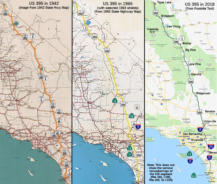 From Route 15 near Cajon Pass to the Nevada state line passing near Little
Lake, Independence, Bridgeport, and Coleville.
From Route 15 near Cajon Pass to the Nevada state line passing near Little
Lake, Independence, Bridgeport, and Coleville.
 Post 1964 Signage History
▸In 1963, Route 395 was defined as:
(a) San Diego to Route 10 near San Bernardino via Temecula and passing near Riverside.
(b) Route 15 near Cajon Pass to the Nevada state line passing near Little Lake, Independence, Bridgeport, and Coleville.
(c) Nevada state line northwest of Reno to the Oregon state line near New Pine Creek via Alturas.
Note that the 1963 definition has a gap between I-10 and the edge of Hesperia. This is because the portion of US 91 (which included US 395 between San Bernardino and Hesperia, and US 66 between San Bernardino and Barstow) was transferred to I-15. Segment (a) represented the future I-215 and I-15 S of I-10.
▸In 1969, Chapter 294 transferred segment (a) to other routes,
leaving "(b)(a) Route 15 near Cajon Pass to the
Nevada state line passing near Little Lake, Independence, Bridgeport, and
Coleville." This is also when US 395's official southern end was changed
to Hesperia. The 1963 segment (a) was parceled out as follows:
The current segment (a) is the original 1963 (b): "Route 15 near Cajon Pass to the Nevada state line passing near Little Lake, Independence, Bridgeport, and Coleville".
There are unconstructed but adopted portions from 3 mi S of Route 18 to 7 mi S of Route 58, and from the San Bernardino County line to 8 mi S of Route 178, for 44 miles parallel to the existing traversable route.
According to Scott Parker on AARoads, there is a pathway preserved for a
US 395 freeway/expressway facility through the west end of Hesperia and
Victorville, extending north from the current US 395 split from I-15 and
closely following the current US 395 alignment, but shifting from one side
(west) to the other (east) from time to time. That continues out to where
US 395 veers slightly NW south of Adelanto. Any freeway alignment would
have to arc west from the current US 395 facility to circumvent
development in that town—but not too far, maybe a mile to a mile and
a half west. That was planned to allow as much of the present US 395 to
remain as a site for commercial activity. Alternate alignments well to the
west have also been proposed; most of those simply skirt the west end of
Victorville development by veering NW from the I-15/US 395 interchange
around the north end of Baldy Mesa and then heading due north (and
steering around the industrial parks in NW Victorville) to align with any
Adelanto bypass; all of which would rejoin current US 395 at some point
north of town. For a time, there was thought of simply multiplexing US 395
traffic with the eastern extension of the High Desert Corridor to
interchange with I-15 north of Victorville, but since the removal of the
freeway portion from those plans, it's likely that US 395 will, when
upgraded, simply use one of the above options to reach the current
interchange in Hesperia.
(Source: Scott Parker on AARoads, "Re: CA-58 Kramer Junction Bypass", 5/30/2020)
Another planned freeway adoption was US 395 between the McGee Maintenance Station south to Crowley Lake Dam Road, adopted at the same time before the 1964 renumbering. This was built as an expressway (with one interchange); Old US 395 became "Crowley Lake Road".
 Pre 1964 Signage History
US 395 was first defined at the June 1934 meeting of AASHTO. An August 15, 1934 letter from AASHTO to the State of Oregon indicated that US 395 had just been established running from the Canadian border to San Diego. In California, by the October 1934 or 1935 signage of routes, US 395 was first signed, along a number of different state signed routes (Sign Route 71, Sign Route 18, US 66, Sign Route 95, Sign Route 7) (and LRNs). It was fully signed by 1938.
Historic US 395 - San Diego to Mirimar NAS
Between US 101 (present-day I-5) in San Diego and a point just S of the Miramar Naval Air Station, US 395 is present-day Route 163 and was LRN 77, defined in 1931.
According to AARoads, the original routing of US 395 (1935-1936) started
at the intersection of US 101 (Morena Boulevard) and Linda Vista Road. It
then turned northeast along Linda Vista Road, joining what is now the I-15
corridor near Miramar. This corresponds to a route shown on the 1930 state
highway map running from US 101 just N of the San Diego River towards
Escondido along what appears to be Linda Vista. The map, however, does not
show route numbers, and also shows routes running (a) along 4th,
University, 6th, Ulric, and Linda Vista towards Miramar, and
(b) along Park, past El Cajon, perhaps across Adams or Madison, and then
up what appear to be Fairmount and using Mission Gorge. By 1934, the route
from US 101 near the San Diego River is gone. What remains are two routes:
(a) the route that uses 4th, University, 6th, Ulric,
and Linda Vista towards Miramar; and (b) the route that would become US 395 along Fairmount using Park and El Cajon. It is unclear if the routes
along Linda Vista or 4th/University/6th were part of
the early state system; all that is clear is that they were not in the
state system as it was codified in 1935, nor were they given sign route
numbers.
(Source: AARoads US 395 Guide; research by site author)
By 1936 the routing had changed. The 1936 State Highway Map City Insert
shows the route in clearer detail (somewhat, that is, because co-signs
within the city are not shown). US 395 started NB from US 101 on Atlantic
using the following route:
(Source: Gribblenation Blog California State Route 163; Old US Route 80/395 on the Cabrillo Freeway)
Note that it appears that prior to the elimination of US 395 signage in
San Diego, US 395 ran along 10th and 11th Ave from
the southern end of Balboa Park (i.e., where Route 163 and I-5 now meet)
to Market Street, where it continued W along Market Street to Harbor Drive
(US 101 until it was eliminated and replaced by I-5). The portion along
Market appears to have been cosigned with Sign Route 94 (LRN 200). At one
point, US 395 may have been extended to the Coronado Ferry which was at the end of Pacific, at least according to some San Diego Council minutes, meaning that the route was
extended down Pacific to Seaport Village. Sign Route 94 may have been
moved from Market to the F/G couplet in 1959.
(Source: Discussion on AARoads, 5/2019. Multiple contributors.)
In 1931, the legislature defined LRN 77 as the route that would become US 395. It was part of segment (1), "Riverside to San Diego (Inland Route)".
In 1938, planning began for the Cabrillo Freeway through Balboa Park. The
corridor was to primarily serve as the new alignment of US 395. The
California Highway Commission made an official alignment adoption on
November 27, 1940. San Diego city voters approved a measure on March 25,
1941, to set aside a two hundred foot right of way for the Cabrillo
Freeway to be constructed. The groundbreaking ceremony for construction of
the Cabrillo Freeway was held on February 6, 1946. The Cabrillo Freeway
was included as priority post-war project number 116 by the state. Designs
for the corridor were completed during 1945. The corridor was opened to
the traffic within the city on February 28, 1948. Following the completion
of the Cabrillo Freeway through Balboa Park, US 80 and US 395 were shifted
onto a new alignment entering downtown San Diego via 11th
Street.
(Source: Gribblenation Blog (Tom Fearer), "The history of US Route 80 and Interstate 8 in California", June 2024)
In 1934, the route of LRN 77 was changed. After the change, LRN 77 went S on Fairmount and terminated at LRN 12 (US 80) on El Cajon Blvd. US 395 was cosigned with US 80 along LRN 12 until the terminus at Market St and 12th. LRN 12/US 395 was later extended west to Pacific Highway (in 1943) . A 1935 map showing routes to the California-Pacific Exposition in Balboa Park clearly shows several US 395 shields along Fairmount, El Cajon Blvd, and Park Blvd (the last two with US 80 shields also). The State Highway map of 1930 does not show Fairmount Blvd at all, but the State Highway map of 1934 does show Fairmount. Some route US 395 along Fairmont as late as 1948. At the time of this change, the start was also moved to have it start (with US 80) at US 101 in downtown San Diego, later the starting point for Route 163 (more information on this historical portion may be found under Route 163). It headed north on Park Blvd with US 80, then headed east on El Cajon Blvd. It split from US 80 at Fairmont Ave, heading north on Fairmount. It crossed the San Diego River just east of current I-15, then ultimately followed that routing north to Miramar Rd / Pomerado Rd. Thus, it appears (based on input from Steve Varner and Cameron Kaiser) that from 1934-1948, US 395 went north along 12th (Park) with US 80 from Market St and then cut over on A St and north on Park "again" to El Cajon, then left US 80 north on Fairmount (potentially meaning that the "interchanges" on Fairmount were originally part of US 395).
Around 1942, US 395 appears to have been routed on Fairmount, then along Camino Del Rio, up what looks like the old Ward Rd, briefly along Friars, and then up Murphy Canyon, Kearny Villa Road, and Pomodaro Road to Escondido. The 1942 map also shows a planned routing slightly to the W that replaced the routing along Murphy Canyon Road with a new routing along Linda Vista Road and Kearny Villa Road between near the current I-805/Route 163 junction and the current Route 163/I-15 junction, and then S along a new alignment that used (approximately) Linda Vista, Ulric, and veered closer to 6th Avenue (most of this has now been subsumed under Route 163).
Around 1948, US 395 was moved to this new routing that included Kearney Villa Road. The Kearny Villa Road alignment was constructed as part
of a major realignment of US 395 in 1949-50, replacing an original road
dating back to the 1910s that was too narrow and inadequate. In the early
1940s, plans were made to improve Kearny Villa Road, but World War II
postponed design and construction until 1948. The updated road was a
expressway running approximately from the current intersection of Route 163 and Clairemont Mesa Blvd. to the intersection of I-15 and Pomerado Rd.
near Lake Hodges. In 1968 the expressway was converted into a full-fledged
freeway. It was modified again in 1976 as part of improvements to I-15. In
1982, a new, wide alignment of I-15 was built to the east of the existing
freeway in the segment between just S of the current Route 163 / I-15
junction and Miramar Road, as there was no room to widen the existing
freeway due to the presence of the Miramar NAS. At that time, the Kerney
Villa Road Expressway/Freeway that was distinct from Route 163 was
relinquished to the County of San Diego.
(Basis: Southern California Rocks and Roads (Michael Ballard), "Southern California Unsigned Freeways » Kearny Villa Road")
Historic US 395 - Miramar NAS through Temecula
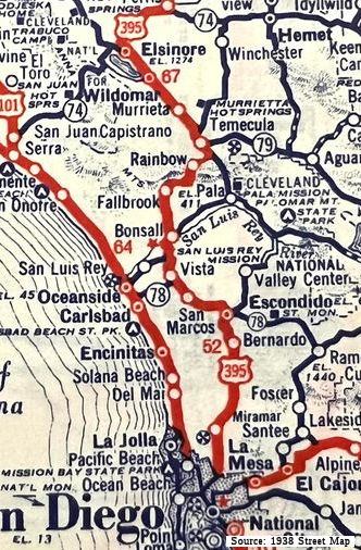 Between a point just S of the Miramar Naval Air Station and 2 mi N of Temecula:
This is present-day I-15, and was LRN 77, defined in 1931. It was signed
as Sign Route 71 between Miramar and Temecula between 1934 and 1935,
before US 395 was first signed. US 395 followed what is now Pomerado Road
from a point 3 miles north of the I-15/Route 163 interchange to the
interchange of Pomerado Road/I-15 at a point just south of the Lake Hodges
/ San Dieguito River crossing near the southern city limits of Escondido.
Between a point just S of the Miramar Naval Air Station and 2 mi N of Temecula:
This is present-day I-15, and was LRN 77, defined in 1931. It was signed
as Sign Route 71 between Miramar and Temecula between 1934 and 1935,
before US 395 was first signed. US 395 followed what is now Pomerado Road
from a point 3 miles north of the I-15/Route 163 interchange to the
interchange of Pomerado Road/I-15 at a point just south of the Lake Hodges
/ San Dieguito River crossing near the southern city limits of Escondido.
(Image source: 1938 Street Map posted on FB by Vicki George Surges)
In Escondido until 1948-49, US 395 was routed 2 blocks to the east of Centre City Parkway along Escondido Blvd. Note how Escondido Blvd has many old motor court style motels from the 20s as well as art deco buildings from the 30s. Note that in the 1950s, US 395 followed four-lane Centre City Parkway. There is still a US 395 mile marker near the downtown area on Centre City Pkwy. Many 1950s era Googie-style cafes remain on this stretch of old highway. Lastly, note that Escondido Blvd (pre-1949 US 395) was actually called San Diego Blvd at the time, as noted on this page from the Escondido Historical Society.
One correspondent notes that in 1939 and 1942, US 395 entered Escondido along Escondido Blvd; thence northeast along Grand Ave; thence northwest along Broadway; thence southwest along Mission Ave (old name Grand Ave) and out of Escondido toward Vista. The U. S. Army Corps of Engineers Escondido Quadrangle 1942 edition shows Escondido Blvd north of Grand as only a dry weather road, and California Highways and Public Works magazine September 1939 page 10 has a small scale map that shows US 395 entering Escondido along a street that is probably Escondido Blvd, then going east to another street that is probably Broadway, then north again.
Until 1949, US 395 headed west along Mission Ave (former Route 78, now San Diego County Sign Route S14), which turns into South Santa Fe Ave west of San Marcos. It continued to travel E/W along South Santa Fe Ave, and then turned north on Vista Way (San Diego County Sign Route S13) to the current junction with Route 76, following it east. Just to the north of this junction there is a beautiful bridge over the San Luis Rey River (Bonsall Bridge), built in 1925 that was supplanted by a modern crossing in the late 1980s. US 395 followed the current routing of Route 76 to Bonsall, where it diverged from the state route, heading north on Mission Ave (San Diego County Sign Route S13). There is another old US 395 bridge on the south side of Fallbrook that was bypassed with road improvements to South Mission. You can find a description here. Not far south of this bridge there is an old alignment of US 395 (between Fallbrook and Bonsall) that was bypassed called Hellers Bend. The road still has that name.
Until 1949, in Fallbrook, US 395 appears to have followed the current
routing of County Sign Route S13 through town and made its 90 degree turn at the same
place as Mission Ave does today. It then followed County Sign Route S13 to a point less
than ¼ mile east of I-15. It rejoined what is now known as "Old
Highway 395" in this area. Note that the current route of Mission Ave
changed in the not-too-distant past. Today, Mission Avenue heads north
into Fallbrook as "South Mission" Ave. Main Street splits from Mission,
heading straight north, while South Mission jogs west, then heads north
along what was once Hill Ave. After crossing Alvarado it becomes "North
Mission." It currently makes a 90° turn to the east and becomes "West
Mission" until crossing Main again after which it is "East Mission", and
heads east to the I-15. According to online maps like those on Yahoo, this
is the path of County S13. However, if you look on Topozone at the 7.5
minute map, this routing does not exist on the 1968 Morro Hill quad.
Instead, from both the topo map and historical descriptions from the
Fallbrook Historical Society that are online, it appears that US 395
followed Mission north until it became Main Street, it then turned
90° east on what the topo calls Juniper St (now East Mission). It
then jogged north, then east as Mission Road, following that east to the
current "Old 395" near the I-15.
(Source: Email from Steve Varn)
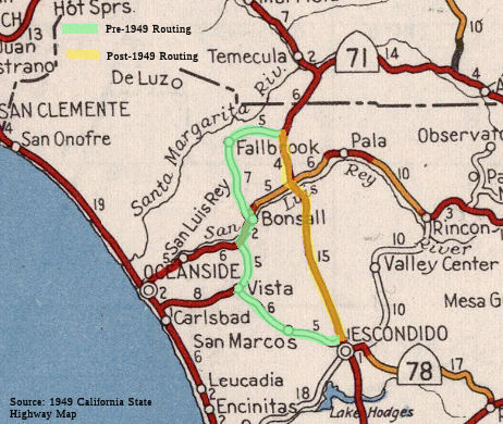 Starting in 1948, state highway maps showed an "under construction" rerouting of US 395 between Escondido and Temecula that essentially took a straight line
routing between a point S of Rainbow (where current "Old 395" crosses I-15
to meet Mission Ave) and Escondido. This routing was completed by 1949.
Starting in 1948, state highway maps showed an "under construction" rerouting of US 395 between Escondido and Temecula that essentially took a straight line
routing between a point S of Rainbow (where current "Old 395" crosses I-15
to meet Mission Ave) and Escondido. This routing was completed by 1949.
In June 1948, construction started on the six-mile section between the
San Diego county line and one mile north of Temecula. The winding old road
over the Santa Rosa Mountains was abandoned in favor of a completely new
expressway with partial control of access, still two lanes in width except
for one short four-lane section, but on vastly superior alignment and
grades suitable for modern-day traffic volumes and speeds. Inability to
attain minimum design passing sight distance at one particularly rugged
stretch was the reason for constructing the short piece of divided
highway. This was one of the early instances in California of a new
freeway skirting the main street of a town. The beneficial effect upon the
little town of Temecula was an example and guide to engineers and local
businessmen in the treatment of subsequent similar freeway problems. This
unit was completed in 1949 at a cost of approximately $780,000.
(Source: CHPW, May/June 1952)
Both iterations of "Old 395" are still driveable. According to one contributor who lives in that area, Old Highway 395 in that area is still well traveled (and mostly well maintained), functioning mostly as a bypass around the border patrol checkpoint for local traffic:
US 395 diverged again to the south of the grade to Temecula Creek, following Rainbow Valley Blvd, where it ultimately joined with current Route 79 (formerly Route 71). The current routing of I-15 was originally a four lane bypass of town, opened in 1949. A relic of the old routing are the two tiny country gas stations on Rainbow Valley Boulevard, their pumps long gone.
In 1915, the road through Temecula was first constructed, spawning
businesses such as the Swing Inn, known as Mother's Cafe and Alesandro's
Place in its earliest days, and other eateries like Mrs. L.M. Hall's
Temecula Lunch Rooms, the B-Bar-H Cafe and the Rite-Spot. The two-lane
concrete road, built by Riverside County, ran from Perris through Murrieta
and into Temecula along Jefferson Avenue and Front Street before heading
up the grade toward Rainbow, according to Phil Brigandi's book, "Temecula
at the Crossroads of History." Eventually designated US 395, that road and
others like it were built to make automobile travel more practical and
comfortable. In 1949, US 395 was rerouted out of the business area and up
to about where I-15 runs today. There were fears in Temecula that the
bypass would severely damage local merchants. A study by the California
Division of Highways showed business at the five cafes in Temecula
decreased more than 18 percent between 1949 and 1950. However, that same
study showed that throughout the entire county the cafe business was also
down about 18 percent in the same period.
(Source: San Diego Union Tribune, 7/28/2005)
Historic US 395 - Temecula to Riverside
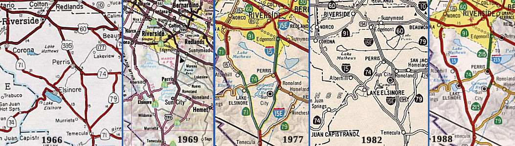 Between 2 mi N of Temecula and Riverside: The original routing was part of LRN 77
(future Route 71) and LRN 78 (future Route 74, I-215 between Perris and
Riverside). Note that the portion between Elsinore and Temecula was both
LRN 77 and LRN 78, until the 1950 rerouting of LRN 78 to the present-day
I-215 routing between Temecula and Perris. LRN 78 was defined in 1931. For
a time it was signed as I-15E. This was part of Route 194 between 1974 and
1982.
Between 2 mi N of Temecula and Riverside: The original routing was part of LRN 77
(future Route 71) and LRN 78 (future Route 74, I-215 between Perris and
Riverside). Note that the portion between Elsinore and Temecula was both
LRN 77 and LRN 78, until the 1950 rerouting of LRN 78 to the present-day
I-215 routing between Temecula and Perris. LRN 78 was defined in 1931. For
a time it was signed as I-15E. This was part of Route 194 between 1974 and
1982.
US 395 signage started in 1935. Until 1950, US 395 was routed along the route of Sign Route 71. The route entered Temecula from the S along Rainbow Canyon Road, turning onto today's Pechanga Parkway (County Sign Route S16) to today's Temecula Parkway (Route 79), and then onto Old Town Front Street. It proceeded slightly NW along Old Town Front Street through Old Town Temecula (which back then, was just Temecula) onto Jefferson. In Murrieta, the co-signed Sign Route 71/US 395 turned onto Ivy (although it might have used Kalmia), and then onto Washington Avenue through downtown Murietta. It continued along Washington, which turns into Palomar. It continued along Palomar, veering onto Mission Trail near Lake Elsinore. At Railroad Canyon Road, Mission Trail turns into Railroad Avenue and then Lakeshore Drive. It continues along Lakeshore Drive until Lakeshore makes a 90° turn and becomes Main Street in Lake Elsinore.
At Granam Ave in Lake Elsinore, US 395/Sign Route 71 met Sign Route 74, which was coming from San Juan Capistrano. Sign Route 71 departed at this point, continuing along Granam Ave with Sign Route 74. Co-signed US 395/Sign Route 74 continued along Main Street to Collier Ave, where it turned back NW and continued to Central Avenue, today's Route 74. Note that today's Route 74 has a slightly different routing in Lake Elsinore between the intersection of Riverside Drive (Route 74) and Lakeshore Drive. Today's Route 74 continues along Riverside directly to Collier, turns and proceeds SE along Collier to Central Ave/Route 74 (where it meets the old routing).
Co-signed Route 74/US 395 then ran E along today's Route 74 to "D" Street in Perris. It then turned N on "D" Street, and along what would become I-215 to Moreno Valley (the route between Perris and Riverside was originally Sign Route 740, renumbered to US 395 after the signage of US 395). Route 74 turned S and ran down "D" Street to 11th Street, across 11th to Case, and then diagonally across Case to Romoland and Matthews Rd, resuming an E/W lateral along Pinacate Road into Hemet. This routing out of Perris was originally Sign Route 740, and then Sign Route 74 after the creation of US 395.
Modernization of US 395 began early in WWII, even though at that time
practically all highway construction was virtually at a standstill,
deferred by the Federal Government in favor of more essential war
production. This segment of US 395 was an exception as the two-lane
section of highway from Riverside to March Field and Camp Haan (since
combined and now known as March Air Reserve Base) was entirely inadequate
for the intensive military traffic that developed. So in just a few short
months in 1942, with a high priority from the War Production Board because
of the strategic importance of the work to the defense effort, the 10-mile
section was converted to a four-lane divided highway. As it did for many
military access roads during the war, the Division of Highways acted as
agent for the Federal Government in designing he work, awarding the
contracts, and supervising construction. Cost of construction totaled some
$1,150,000, including a grade separation at the junction with US 60.
(Source: CHPW, May/June 1952)
In 1950, the first contract was awarded for reconstructing US 395 on
entirely new alignment between Temecula and Perris. As noted above, the
original route followed Temescal Canyon and Sign Route 71 from Temecula to
Elsenore, diagonally NW from Elsinore to Perris along Sign Route 74, and
then N up "D" Street out of Perris. The new route took off a mile north of
Temecula in a northerly direction on entirely new alignment through the
Antelope and Menifee Valleys, crosses Sign Route 74 near Romoland and
then, turning northwesterly, skirts the business section of Perris to
connect with the present highway. The total distance is just 22 miles as
compared to 30 miles via the old route. Although the bypass was originally
constructed as two-lanes, with provisions for ultimate development to four
lanes divided, with partial control of access. The cutoff was being
constructed in three units. The first, from one mile north of Temecula to
Antelope Road, seven miles in length, was completed in April, 1952, at a
cost of $725,000. The second unit, 10.5 miles in length, from Antelope
Road to LRN 64 (Sign Route 74) was started in September 1951, and work
completed in September 1952. The estimated cost of construction is
$800,000. The third unit, 4.7 miles in length, from LRN 64 to Nuevo Road
started construction in summer 1952. $850,000 had been budgeted for its
construction. The construction between Sign Route 74 south of Perris and
Nuevo Road north of that city was finished by the E. L. Yeager Company of
Riverside on September 30, 1953, 50 days ahead of schedule, at a cost of
$762,000. The new highway bypassed the city to the east, with easy access
provided for traffic entering and leaving town. An interchange north of
Perris ("D" Street) was constructed to eliminate conflicting traffic
movements. Another grade separation was provided at Perris Boulevard to
permit local traffic and school children to cross the high-speed new
facility with safety.
(Source: CHPW, May/June 1952; CHPW Jan/Feb 1954)
The US 395 designation was moved to a direct routing in 1952-1953 between Temecula and Perris (present-day I-215) upon completion of construction of the new highway. The older dogleg routing through Elsinore remained as Sign Route 71 (eventual I-15) and Sign Route 74. Note that the routing from Route 111 near Indian Wells through Perris to Riverside was originally signed as part of Route 740; in 1935, the portion from Perris to Riverside became US 395, and the remainder became part of Sign Route 74.
The section from Nuevo Road to the beginning of the divided highway at
March Air Force Base, was proposed for development to a four-lane divided
highway, utilizing the existing two-lane road for southbound traffic. By
1952, plans had been completed and right of way had already been acquired
with partial control of access. By December 1953, this segment had been
completed, at a cost of $407,000
(Source: CHPW, May/June 1952; CHPW Jan/Feb 1954)
Between Jct US 60/US 91 and Jct US 60/US 395 (i.e., through Riverside): The route was cosigned as US 60/US 395, and was LRN 19 (defined in 1909). This is currently I-215 (cosigned with Route 60), although for a time it was signed as I-15E. This was part of Route 194 between 1974 and 1982.
In Riverside, US 395 entered from the S along Box Springs Blvd, joining with US 60 N of Edgemont (now Moreno Valley). Cosigned US 395/US 60 continued NW along Box Springs Blvd, and then W along University/8th Street. At Market Street, US 395 turned NE along Market (cosigned with Sign Route 18, which became US 91) while US 60 continued SW. Cosigned US 395/Sign Route 18/US 91 continued up Market, making a right turn at 1st, then left onto Main Street, and then right on Russell Street, where it picked up La Cadena. It followed La Cadena towards San Bernardino.
Historic US 395 - Riverside to San Bernardino
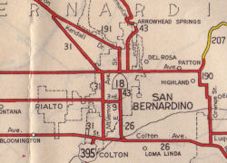 Between Riverside and San Bernardino: The route was
cosigned as US 91/US 395, and was LRN 43 (defined in 1931). This is
currently I-215, although for a time it was signed as I-15E. This was part
of Route 194 between 1974 and 1982, and although signed as US 395, Route 15 between 1969 and 1974. As the 1944 map shows, US 395 entered the San
Bernardino area near Colton, where the routing dropped the cosigning with
Sign Route 18 (although it remained cosigned with US 91), and continued N
along Mt. Vernon as LRN 31.
Between Riverside and San Bernardino: The route was
cosigned as US 91/US 395, and was LRN 43 (defined in 1931). This is
currently I-215, although for a time it was signed as I-15E. This was part
of Route 194 between 1974 and 1982, and although signed as US 395, Route 15 between 1969 and 1974. As the 1944 map shows, US 395 entered the San
Bernardino area near Colton, where the routing dropped the cosigning with
Sign Route 18 (although it remained cosigned with US 91), and continued N
along Mt. Vernon as LRN 31.
In 1949, work began on the segment of US 395 between the City of
Riverside and the San Bernardino county line, along the section known
locally as La Cadena Drive, which then was a two-lane highway. In May,
1949, the 2.6-mile section between Russell Street and the county line was
awarded to contract. This was the only section of US 395 at the time with
full control of access. The freeway consists of a four-lane divided
section, with the median divider wide enough for future development to
six-lanes divided when warranted by traffic. Frontage roads parallel the
freeway throughout its length; the one on the west side was the old
highway. Although at the time it was not yet a freeway in the full sense
of the word, (as there were several road crossings at grade), it was
proposed to construct grade separations at these locations at some future
date when funds became available. This section of US 395 was also designed
to fit into the plan for the ultimate freeway location through Riverside,
Colton, and San Bernardino. The La Cadena unit of US 395 was completed in
June, 1950, at a cost of $550,000.
(Source: CHPW, May/June 1952)
Historic US 395 - San Bernardino
 US 395 left
Riverside along Main Street via LRN 43. It jogged over to La Cadena just N
of Riverside, and followed La Cadena to Valley Blvd (LRN 26, US 70/US 99).
It followed Valley to Mt Vernon, where it turned and went N on Mt. Vernon
as cosigned US 91 / US 395 (and, N of LRN 9, US 66). With the construction
of the LRN 43/LRN 31 freeway, things changed. US 91 / US 395 followed the
LRN 43 / LRN 31 freeway (today's I-215) up and into Verdemont, with the
transition between LRN 43 and LRN 31 seemingly taking place at LRN 9, but
actually at the point where LRN 43 split off from LRN 31, with LRN 31
heading toward the Cajon Pass, and LRN 43, signed as Sign Route 18, going
up to Sign Route 30 (LRN 190), across Sign Route 30 to Waterman, and then
up Waterman. (Sign Route 30 later became Route 210)
US 395 left
Riverside along Main Street via LRN 43. It jogged over to La Cadena just N
of Riverside, and followed La Cadena to Valley Blvd (LRN 26, US 70/US 99).
It followed Valley to Mt Vernon, where it turned and went N on Mt. Vernon
as cosigned US 91 / US 395 (and, N of LRN 9, US 66). With the construction
of the LRN 43/LRN 31 freeway, things changed. US 91 / US 395 followed the
LRN 43 / LRN 31 freeway (today's I-215) up and into Verdemont, with the
transition between LRN 43 and LRN 31 seemingly taking place at LRN 9, but
actually at the point where LRN 43 split off from LRN 31, with LRN 31
heading toward the Cajon Pass, and LRN 43, signed as Sign Route 18, going
up to Sign Route 30 (LRN 190), across Sign Route 30 to Waterman, and then
up Waterman. (Sign Route 30 later became Route 210)
The original LRNs in San Bernardino were equally convoluted according to Scott Parker (Sparker). The "spine" LRN through the region was LRN 43, which followed Sign Route 18 throughout the region; a number of long-distance LRNs terminated at this legislative route. LRN 26 was US 99 south of the 3rd Street/E Street intersection, following US 99 all the way to the Mexican border at Calexico. LRN 31, which carried US 66 over Cajon Pass to Barstow, and US 91 (which was not extended south of Barstow until 1947) northeast from there to Nevada, began at the junction of Mt. Vernon and 3rd Street and was the Mt. Vernon RR bridge and US 66 east from there. LRN 9 was US 66, and originally US 99, extending west from LRN 31 on 4th Street toward Pasadena. Sign Route 30/Highland Ave. was LRN 190, and North E Street and Kendall Ave. Business US 66 was LRN 191.
Scott Parker (Sparker) noted in that discussion that this arrangement didn't last long; the bridge over the Santa Ana River connecting Colton Ave. in the south reaches of San Bernardino with Valley Blvd. in central Colton was completed circa 1931; LRN 26 and US 99 were rerouted west along that alignment. South E Street from the rerouted US 99/LRN 26 became a realigned but unsigned LRN 43. 3rd Street, still carrying Sign Route 18, became an eastern extension of LRN 9, which terminated at 3rd and E Street at LRN 43 (Sign Route 18 still turned north there). The entirety of Mt. Vernon north of Valley Blvd. in Colton was reassigned to LRN 31; it still carried Sign Route 18 south of 3rd Street until US 395 was commissioned in 1934 to join it. US 99/LRN 26 continued west from Colton on Valley Blvd. into Ontario, where it was renamed Holt Ave.
Similar to 4th street west of Mt. Vernon, 3rd
Street past the original Santa Fe depot (now used by Metrolink &
Amtrak) east of the Mt. Vernon bridge features portions of the original
segmented concrete pavement that once carried US 99 and Sign Route 18. The
east-west Valley Blvd. alignment that eventually became US 99/LRN 26 was
in place as a county facility at the time. US 99 was routed through
central San Bernardino, with its east end at or near Mt. Vernon Ave. in
Colton. The delay involved with realigning US 99 was due to the difficulty
experienced in constructing bridges over the Santa Ana River; the riverbed
consists of deep layers of sand and silt lying in scooped-out sandstone
with no supporting bedrock to speak of. Bridge construction over such a
"waterway" required placing concrete caissons deep into the sand and
waiting for them to settle before constructing bridge piers upwards from
them -- then letting the whole assembly settle even more before extending
a bridge deck over the piers. This method has continued to this day; the
I-10, I-215, and Route 210 bridges over the Santa Ana River were deployed
in a similar manner. The original US 99 E Street bridge was the only
exception; it was a relatively light "trestle" structure sitting atop the
silt layers; it was replaced by the present caisson-based structure in the
mid-'60's, a few years after the original I-10 and I-15 (now I-215)
bridges were built.
(Source: Scott Parker (Sparker) @ AAroads, 7/7/2016)
Historic US 395 - San Bernardino to Devore
Between San Bernardino and Devore: The route was cosigned as US 91/US 66/US 395, and was LRN 31 (defined in 1915). This is currently I-215, although for a time it was signed as I-15E. This was part of Route 194 between 1974 and 1982. The portion between former US 66 and Route 14 (former Route 7) was originally part of state signed Route 95, defined in 1934, renumbered to US 395 upon the definition of US 395.
In this segment, the routing was originally along Cajon Blvd. The US 395 / US 91 / US 66 met Alt US 66 just S of Devore. US 66 (LRN 9) entered from the W along Foothill, turning onto Fifth, and then Mt. Vernon, where it joined US 91 / US 395 and continued N to Cajon Blvd. There was a small section of Business Route 66 / Sign Route 18 along Fifth between Mt. Vernon and S "E" Street, that continued up E Street to Kendell Drive where it rejoined the main line just S of Devore. The Business Route 66 routing became Route 206 in 1964.
Historic US 395 - Devore to 7mi SW of Victorville
Between Devore and 7 mi SW of Victorville: The route was cosigned as US 66/US 91/US 395, and was LRN 31, defined in 1915. The routing ran along Cajon Blvd, Wagon Train Road, FR 3N21 Baldy Mesa Road, Santa Fe Fire Road, and what is now an electrical maintenance road through Cajon Summit, and later Mariposa Road.
Where Wagon Train Road dead-ends into the Pacific Crest
Trail, sits a mostly forgotten landmark: the rest stop that essentially
invented the idea of rest stops. Today, what stands at Camp Cajon is a
layered history of the importance of California’s Cajon Pass to
generations of travelers in the state. The Cajon Pass is a ragged access
point squeezed between the San Gabriel and San Bernardino Mountains,
serving as the only route through the two ranges that doesn’t
involve climbing up and over tall peaks. In December 1917, Inland Empire
bigwigs gathered near Crowder Canyon in the Cajon Pass to dedicate a
monument to the 19th-century pioneers from Utah who had
traversed the pass in 1851 to establish what would later become the city
of San Bernardino. But while attending the event memorializing the Cajon
Pass travelers of the past, orange grower William Bristol noticed
something: The mountain pass’s busiest days were likely still ahead.
During the dedication ceremony, a wave of cars continuously chugged past
along what was then known as National Old Trails Road. The roadway, opened
in 1913, was a precursor to the modern national highway system, and was
dubbed the country’s first “Ocean to Ocean Highway.”
Thirteen years later, the road would become a key piece of Route 66, and
by then, Bristol’s roadside empire was in full swing. Travelers from
across the country who had pointed their cars toward Cajon Pass knew that
once they saw the American flag rising above a stone marker entrance,
they’d reached what was widely called the “Gateway to Southern
California.” Camp Cajon offered a free auto camp, with picnic
tables, stoves and barbecue pits. Amenities included a bandstand, stores
and gas stations, a post office, restrooms and a castlelike outpost of a
fraternal organization, the Knights of Pythias. Michigan’s Iron
County established the Midwest state’s first roadside park in 1918,
which is considered “likely America’s first such
facility” — Camp Cajon’s 1919 opening date likely also
places it among the first roadside stops in the country. Camp Cajon was
ultimately short-lived. Southern California’s Great Flood of 1938
destroyed much of the camp’s facilities, and officials ultimately
opted against rebuilding the camp in order to help widen Route 66. In
2019, local historical societies dutifully rebuilt the camp’s most
popular landmark, a stone structure reading “Camp Cajon,”
covered with poems and topped with an American flag. In recent years, the
San Bernardino Historical Society and other groups have continued their
efforts to restore an otherwise mostly forgotten landmark, adding an
informational kiosk and a monument sign for the Santa Fe and Salt Lake
trails, and returning one of the original cement tables that had spent 80
years sitting in San Bernardino’s Lytle Creek Park.
(Source: SFGate, 2/27/2026)
Hesperia to the Nevada State Line
Near Hesperia—specifically, 7 mi SW of Victorville—the current US 395 starts. For this segment:
According to the state highway map, there were plans to straighten US 395 N of Adelanto to a point N of where it crossed (unconstructed) Route 122 about 10 mi S of Kramer Jct.
According to the state highway map, there were plans in the late 1960s and early 1970s to reroute and straighten US 395 between Johannesberg and the interconnection with Sign Route 7 / US 6. This shows as a planned route on the map (1966-1970), but only the portion from China Lake Blvd to US 6 was constructed.
Near Inyokern, there was a significant rerouting around 1967. The original routing used Brown Road between S China Lake Blvd to where Brown Road met US 6 near the community of Brown. In 1958, US 395 was rerouted N of the Inyokern Airport (where Brown meets La Fortune Lane) to instead turn NW to meet Sign Route 7/US 6, bypassing the community of Brown. In 1967, US 395 was rerouted to the current routing, which uses a direct NW diagonal from China Lake Blvd. Google Satellite Maps show the old routing pretty clearly. Note that Open Street Maps shows China Lake Blvd into Ridgecrest, returning to US 395 along Route 178, as Business Route 395; however, that routing does not appear to have ever been signed as US 395.
There may have been some reroutings near the Haiwee Reservoir.
Note that, in Olancha, S of Falls Road, there is a street named "Old State Highway". This connects to Walker Creek Road. It is unclear when this segment went out of service. Further, in 2025, US 395 was moved to a new bypass alignment. The old alignment became Route 190 and a county highway. Much of the old alignment is signed Business Route 395. See the STATUS discussion below for the details of the Olancha rerouting.
In Ft. Independence, US 395 used Shabell Lane until a bypass was constructed in the 1970s. N of Fort Independence, US 395 used Tinnemaha Road and "Old Highway 395". The bypass was constructed in the late 1960s.
In Bishop, Wye Road W of US 6 is a former alignment of US 395.
From the area near Mesa (~ INY R126.101) to a point S of Tom's Place (MNO 9.336), there was a significant rerouting of US 395. The old route used Old Sherwin Grade Road / Lower Rock Creek Road. The bypass was completed by the late 1950s.
North of Tom's Place to near Crowley Lake (~ MNO R10.046 / MNO R18.042), US 395 used to use Crowley Lake Drive.
East of the Route 203 interchange, "Old Highway" takes a routing paralleling Mammoth Creek for a bit and crossing it a bit northeast of the current US 395 expressway. This is an older routing of US 395. It serves as a connection to several local roads, including a forest route along Antelope Springs Road. However, it is unclear if Old Highway directly connects with existing US 395 (Mapquest shows it as doing so; MSN's map service does not).
Near June Lake, some segments of Pumice Mine Road are old US 395. There is also an unnamed road connecting to Pumice Mine Road to the S/SW that goes back to US 395 that was old US 395. North of June Lake, where the highway divides, the western roadway (SB) was the original US 395.
An "Old State Highway Road" parallels Route 120/US 395 from south of West Portal Road on the east side of Grant Lake all the way north to Oil Plant Road south of Lee Vining. (This is shown on Mapquest and on Compass's maps.)
Near the N end of Mono Lake (~ MNO 55.664) to near the jct. with Route 167 (MNO 57.966) there is an "Old 395" / Schoolhouse Road that is a former routing of US 395. There was also some route reworking N of the Jct. with Route 167 (approx MNO 59.876 through MNO 63.147), although it appears that there the old route was abandoned and not retained in the county road system. There may still be some old dirt segment near Conway Ranch Road that are visible on the satellite map views.
There is also some dirt US 395 between MNO R66.443 and MNO R67.073 visible on the satellite view maps.
 Business Routes
In Olancha, the old alignment of US 395 is signed Business Route 395. Portions are a new segment of Route 190, and portions are county route. Both represent segments of original US 395 that were bypassed by an expressway in the early 2020s.
 In Ridgecrest, Business Route 395 is approximately 16 miles long. The Business Route begins at the US 395/Route 178 interchange near Inyokern. Business Route 395
multiplexes eastbound Route 178 on Inyokern Road and China Lake Boulevard
to the intersection with Ridgecrest Boulevard. Route 178 continues east
towards Trona on Ridgecrest Boulevard whereas Business Route 395 continues south on
China Lake Boulevard to mainline US 395. The Business Route 395 in Ridgecrest is a
rare example of AASHTO approving a designation that was never a former US Route segment. On January 4, 1989, the Ridgecrest city council formally
requested Caltrans submit a request to AASHTO for the designation of US 395 Business. The Caltrans application dated February 24, 1989, was
considered and approved by the AASHTO Executive Committee on June 7, 1989.
In Ridgecrest, Business Route 395 is approximately 16 miles long. The Business Route begins at the US 395/Route 178 interchange near Inyokern. Business Route 395
multiplexes eastbound Route 178 on Inyokern Road and China Lake Boulevard
to the intersection with Ridgecrest Boulevard. Route 178 continues east
towards Trona on Ridgecrest Boulevard whereas Business Route 395 continues south on
China Lake Boulevard to mainline US 395. The Business Route 395 in Ridgecrest is a
rare example of AASHTO approving a designation that was never a former US Route segment. On January 4, 1989, the Ridgecrest city council formally
requested Caltrans submit a request to AASHTO for the designation of US 395 Business. The Caltrans application dated February 24, 1989, was
considered and approved by the AASHTO Executive Committee on June 7, 1989.
(Source: Tom Fearer on AARoads, "US Route 395 Business in Ridgecrest", 11/24/2024; Gribblenation Blog, "US Route 395 Business in Ridgecrest, California", April 2025)
 Status
In November 2011, the first workshop for the "Historic Highway 395 Corridor Study" project, also known as the Jefferson Avenue Corridor project, was held in Murrieta. The 16-mile arterial corridor is proposed to parallel the west side of I-15 where old US 395 used to travel. It would extend from Rancho California Road along Jefferson Avenue through the cities of Temecula and Murrieta, continuing along Palomar Street and Mission Trail through the cities of Wildomar and Lake Elsinore, and continuing along East Lakeshore Drive to Main Street in Lake Elsinore. Additional information may be found at http://www.highway395corridorstudy.org/.
Note: The bulk of the information on the High Desert Corridor is discussed with Route 138.
The SAFETEA-LU act, enacted in August 2005 as the reauthorization of TEA-21, provided the following expenditures on or near this route:
Jct I-15 to Jct Route 14 near Inyokern
In July 2007, the CTC relinquished right of way in the city of Hesperia, at Outpost Road, consisting of reconstructed and relocated city street. The City, by relinquishment cooperative agreement dated April 16, 2007, waived the 90-day notice requirement and agreed to accept title upon relinquishment by the State.
US 395 Expressway / Realignment
The SAFETEA-LU act, enacted in August 2005 as the reauthorization of TEA-21, provided the following expenditures on or near this route:
There are currently plans to realign US 395 near the cities of Oak Hills, Hesperia, Victorville, Adelanto and incorporated areas of San Bernardino County. This is based off of a draft EIR. The plan is to realign US 395 from the I-15/US 395 interchange (approx SBD R3.981) to Farmington Road. The proposed US 395 Realignment Freeway/Expressway corridor to be evaluated is located either on existing US 395 or west of existing US 395, through the cities of Oak Hills, Hesperia, Victorville, Adelanto and incorporated areas of San Bernardino County. The entire proposed project length is approximately 45.0 miles long. There are four alternatives currently being considered:
In June 2016, it was reported that state financial
issues have resulted in all STIP funding being removed from the 395
Expressway Project which would widen Route 395. But Caltrans will continue
to seek funding to complete widening of existing Route 395, according to
Caltrans spokeswoman Terri Kasinga.
(Source: Mass Transit, 6/6/2016)
In June 2021, it was reported that the CTC approved $1.3 million for a
project on US 395 in Hesperia for the construction of a 4-foot median,
with the addition of rumble strips and standard shoulders. The portion of
US 395 in Hesperia is a north-south roadway that stretches from I-15 north
to the California Aqueduct in Victorville (~ SBD R3.99 to SBD 6.843).
(Source: Victorville Daily Press, 6/29/2021)
US 395 Widening - I-15 to Route 18 (~ SBD R3.99 to SBD 11.22)
In March 2015, the CTC approved for future consideration of funding a project in San Bernardino County that will construct operational efficiencies on US 395 from 0.16 mile north of the junction of US 395 and I-15 in the city of Hesperia to approximately 1.80 miles south of Desert Flower Road in the city of Adelanto. The project is programmed in the 2014 State Transportation Improvement Program. The total estimated cost is $55,191,000 for capital and support. Construction is estimated to begin in Fiscal Year 2016-17. The scope, as described for the preferred alternative, is consistent with the project scope programmed by the Commission in the 2014 State Transportation Improvement Program.
In July 2018, it was reported that this phase has received environment clearance, and is on hold pending construction funding.
In January 2022, the CTC approved including "Widen
sections of US 395 from two to four lanes between I-15 and Palmdale Road
in the Cities of Hesperia and Victorville " in the list of projects for
the Coronavirus Response and Relief Supplemental Appropriations Act of
2021 (CRRSAA). The CRRSAA Program guidelines require regions submit a
project list for allocation by the Commission prior to the obligation of
funds. Under CRRSAA, the funds may be used for a broad range of surface
transportation purposes listed in Section 113(b) of Title 23 of the U.S.
Code and are meant to “prevent, prepare for, and respond to
coronavirus.” Specifically, CRRSAA allows states to cover revenue
losses, which is important given that California’s State-generated
transportation revenues have declined by about $1.5 billion due to the
pandemic. Additionally, CRRSAA allows the funds to be used for preventive
and routine maintenance; operations; personnel; salaries; contracts; debt
service payments; and availability payments; as well as transfers to
public tolling agencies. At the March 2021 Commission meeting, the CTC
approved the CRRSAA funding distribution and regional apportionments. The
CRRSAA allocation for this project was $9,960,528 .
(Source: January 2022 CTC Minutes, Agenda Item
2.5k)
On March 16, 2022, the CTC approved the 2022 State
Transportation Improvement Program, which included the following project:
PPNO 3019L "Rt 395 Freight Mobility, Rt 15-Rt 18, Ph2 (SB1)", 18,647,000
in FY 25-26.
(Source: "2022 State Transportation Improvement
Program", Adopted March 16, 2022)
In May 2025, the CTC approved the following SB1 TCEP
allocation: $30,000,000. 08-SBd-395 4.0/11.2. PPNO 08-3019L; ProjID
0813000222; EA 0F633. US 395 - Phase 2 Freight Mobility and Safety
Project-CON Mainline. This project is located on US 395 between
Route 18 (Palmdale Rd) and I-15 in the Cities of Hesperia and Victorville.
The project will convert this 7-mile section of state highway between I-15
and Route 18 from 2 lanes to a 4-lane facility with a raised median,
turning lanes, eight-foot shoulders, improved pedestrian/bicycle
accommodations, and signal upgrades at intersections and will provide a
contribution to zero-emission fueling infrastructure for trucks at a site
near the US 395/I-15 junction. CEQA - MND, 12/30/2009; Re-validation
04/21/2025. NEPA - CE, 12/31/2009; Re-validation 04/21/2025. Future
consideration of funding approved under Resolution E-15-12; March 2015.
Right of Way Certification: 05/01/2025. Time Extension for FY 23-24 CON
expires December 31, 2025. Allocation: CONST $30,000,000.
(Source: May 2025 CTC Agenda, Agenda Item 2.5s.(5))
In February 2026, it was reported that construction was
beginning on a seven-mile stretch of US 395 in the Victor Valley as part
of the second phase of a major freight mobility and safety project. Early
work will include the removal of brush and debris along the highway
shoulders to prepare the roadway for construction. The project, led by the
San Bernardino County Transportation Authority (SBCTA) and California
Department of Transportation (Caltrans), will upgrade the existing
two-lane segment of US 395 between Route 18 in Victorville and I-15 in
Hesperia and Oak Hills.
(Source: Victor Valley News, 2/17/2026)
US 395 Median Buffer Project (08-SBd-395, PM R4.8/7.6)
In June 2021, the CTC amended the following project
into the 2020 SHOPP: 08-SBd-395 4.8/7.6 PPNO 3017R ProjID 0821000009 EA
08-1L890. US 395 In and near Hesperia, from north of Joshua Street to
Eucalyptus Street. Construct four-foot median, standard shoulders, and
rumble strips and upgrade guardrail. PA&ED $1,302K; PS&E $1,635K;
R/W Sup $931K; ⊘Con Sup
$1,757K; ⊘R/W Cap $1,664K; ⊘Const Cap $7,652K TOTAL $14,941K.
Begin Const: 5/2/2025. It is also approved the following pre-construction
allocation: 08-SBd-395 4.8/7.6. PPNO 3017R; ProjID 0821000009; EA 1L890.
US 395 In and near Hesperia, from north of Joshua Street to Eucalyptus
Street. Construct four-foot median, standard shoulders, and rumble strips
and upgrade guardrail. (Concurrent amendment under SHOPP Amendment
20H-008; June 2021.) Allocation: PA&ED $1,302,000 (24-25).
⊘: Phase
not programmed.
(Source: June 2021 CTC Agenda/Minutes, Agenda Item
2.1a.(1a) #10; June 2021 CTC Agenda, Agenda Item 2.5b.(2a) #26)
In June 2023, the CTC approved the following project
for future consideration of funding: 08-SBd-395, PM R4.8/7.6 US 395
Median Buffer Project. Construct a four-foot median buffer and
maintain existing centerline rumble strips and install shoulder rumble
strips. The project also proposes to widen the existing roadbed and
upgrade an existing culvert on US 395, in San Bernadino County. (MND)
(PPNO 3017R) (SHOPP). The project is located on US 395 from PM R4.8 to PM
7.6, in San Bernardino County. The Department proposes to construct
four-foot median, standard shoulders, rumble strips, and upgrade
guardrail. In addition, a drainage culvert and down drain facility needs
widening due to the widening of the roadbed. The project is currently
programmed in the 2022 SHOPP for a total of $14,941,000, which includes
Right of Way (Support and Capital) and Construction (Support and Capital).
Construction is estimated to begin 2024-25. The scope, as described for
the preferred alternative, is consistent with the project scope as
programmed by the Commission in the 2022 SHOPP. A copy of the MND has been
provided to Commission staff. The project will result in less than
significant impacts to the environment after mitigation. The following
resource areas may be impacted by the project: desert tortoise, nesting
birds, bats, rare plants, burrowing owl, and Mojave ground squirrel.
Avoidance, minimization, and mitigation measures will reduce any potential
effects to the environment. These measures include, but are not limited
to, environmentally sensitive area fencing, pre-construction surveys, and
environmental awareness training. As a result, a MND was completed for
this project.
(Source: June 2023 CTC Agenda, Agenda Item 2.2c.(1) Item 8)
US 395 Widening - Route 18 to Chamberlaine Way (SBD 11.2 to SBD 16.3)
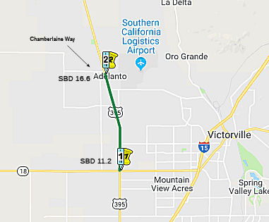 In March 2015, the CTC allocated $5,550,000 to SANBAG for US 395 Interim
Widening. In Hesperia, Victorville and Adelanto. Widen US 395, from Route 18 to Chamberlaine Way (08-SBd-395, PM 11.2/16.6), from two lanes to four
lanes and construct left-turn channelization at various intersections.
In March 2015, the CTC allocated $5,550,000 to SANBAG for US 395 Interim
Widening. In Hesperia, Victorville and Adelanto. Widen US 395, from Route 18 to Chamberlaine Way (08-SBd-395, PM 11.2/16.6), from two lanes to four
lanes and construct left-turn channelization at various intersections.
In August 2016, it was reported that Measure I funding
included widening of US 395 from Mojave Drive (~ PM SBD 12.633) south to
Star Street (~ PM SBD 12.385), which is expected to cost $4.1 million,
with 63.5 percent of the funding required from development impact fees.
(Source: VV Daily Press, 8/26/2016)
The 2018 STIP, approved at the CTC March 2018 meeting, appears to allocate $9.333M for PPNO 0260J Widening, Rt 18-Chamberlaine Way (~ SBD 11.22 to SBD 16.742).
In July 2018, it was reported that work was scheduled
to begin in Fall 2018 on nearly $60 million in improvements to the busy
stretch of highway between Route 18 and Chamberlaine Way — a major
freight traffic route and passenger corridor that connects economic
centers, recreation areas, cities and rural communities. These
improvements will widen that portion of the highway by providing two lanes
in each direction, and includes the addition of turn pockets and signals
at key intersections along the corridor. The start of construction is the
culmination of years of planning and securing the funds needed to make it
happen, including nearly $18 million in voter-approved Measure I funds,
the half-cent sales tax measure for San Bernardino County. The San
Bernardino County Transportation Authority (SBCTA) is partnering with the
California Department of Transportation (Caltrans) to see this and
subsequent phases of the 395 improvement project through completion. Tthe
Victorville-to-Adelanto leg is just one of three phases of an overall US 395 plan for which state and federal funds have been secured. Those future
phases — from Interstate 15 to State Route 18 and from Chamberlaine
Way to Desert Flower Road — have received environmental clearance
and should begin once those additional funds are obtained. It is
anticipated to be open in Fall 2020, with project closure in late 2021.
(Sources: VV Daily Press, 6/24/2018; U.S. 395 Phase 1 Project Page; June 2018 Project Fact Sheet)
In August 2018, the CTC approved an allocation of
$33,625,000 for the locally-administered multi-funded Senate Bill 1 (SB 1)
Trade Corridor Enhancement Program (TCEP)/State Transportation Improvement
Program (STIP) Route 395 Widening from Route 18 to Chamberlaine Way
project (PPNO 0260J), in San Bernardino County.
(Source: August 2018 CTC Agenda Item 2.5s.(9))
The 2020 STIP, approved at the March 2020 CTC meeting,
continues programmed funding for PPNO 0260J Rt 395 Widening, Rt
18-Chamberlaine Way (TCEP).
(Source: March 2020 CTC Agenda, Item 4.7, 2020 STIP
Adopted 3/25/2020)
US 395 Widening - Adelanto (SBD 15.95) to Desert Flower Road (~ SBD 21.086) and beyond to SBD 36.40
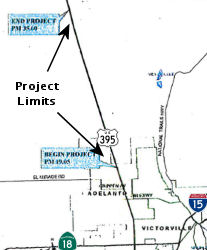 In May 2012, the CTC approved for future consideration of funding a project in San Bernardino
County that will widen the median and shoulders along US 395 (PM 15.95 -
PM 36.40), install rumble strips, resurface the roadway, and widen the
following intersections to accommodate the new width of US 395: Colusa
Road. Desert Flower Road. Purple Sage Street, Shadow Mountain Avenue, Sun
Hill Ranch, and Princess Pat Mine. The project is programmed in the 2010
State Highway Operation and Protection Program (SHOPP). The total
estimated project cost is $55,460,000 for capital and support.
Construction is estimated to begin in Fiscal Year 2012-13. The scope, as
described for the preferred alternative, is consistent with the project
scope programmed by the Commission in the 2010 SHOPP.
In May 2012, the CTC approved for future consideration of funding a project in San Bernardino
County that will widen the median and shoulders along US 395 (PM 15.95 -
PM 36.40), install rumble strips, resurface the roadway, and widen the
following intersections to accommodate the new width of US 395: Colusa
Road. Desert Flower Road. Purple Sage Street, Shadow Mountain Avenue, Sun
Hill Ranch, and Princess Pat Mine. The project is programmed in the 2010
State Highway Operation and Protection Program (SHOPP). The total
estimated project cost is $55,460,000 for capital and support.
Construction is estimated to begin in Fiscal Year 2012-13. The scope, as
described for the preferred alternative, is consistent with the project
scope programmed by the Commission in the 2010 SHOPP.
In July 2018, it was reported that this phase (at least the portion between Adelanto and Desert Flower Road) has received environment clearance, and is on hold pending construction funding.
In August 2018, the CTC approved $15,171,000 in SHOPP funding for San
Bernardino 08-SBd-395 35.5/39.1 US 395 Near Adelanto, from 1.0 mile south
of Kramer Hills to 2.6 miles north of Kramer Hills. Outcome/Output: Widen
median and shoulders and construct rumble strips. This project will
increase safety and reduce the number and severity of collisions.
(Source: August 2018 CTC Agenda Item 2.5f.(3) Item
14)
Kramer Hills Widening
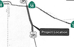 In October 2015, the CTC approved for future
consideration of funding a project in San Bernardino County that will
construct a median barrier, widen shoulders, and install rumble strips on
US 395 near the community of Kramer Hills. The project is programmed in
the 2014 State Highway Operation and Protection Program. The total
estimated cost is $40,657,000 for capital and support. Construction is
estimated to begin in Fiscal Year 2017/18. The scope, as described for the
preferred alternative, is consistent with the project scope programmed by
the Commission in the 2014 State Highway Operation and Protection Program.
A copy of the MND has been provided to Commission staff. (Approx SBD
38.633 to SBD 46.207)
In October 2015, the CTC approved for future
consideration of funding a project in San Bernardino County that will
construct a median barrier, widen shoulders, and install rumble strips on
US 395 near the community of Kramer Hills. The project is programmed in
the 2014 State Highway Operation and Protection Program. The total
estimated cost is $40,657,000 for capital and support. Construction is
estimated to begin in Fiscal Year 2017/18. The scope, as described for the
preferred alternative, is consistent with the project scope programmed by
the Commission in the 2014 State Highway Operation and Protection Program.
A copy of the MND has been provided to Commission staff. (Approx SBD
38.633 to SBD 46.207)
In August 2017, the CTC allocated $28,597,000 for San Bernardino 08-SBd-395 39.0/45.9 US 395: Near Adelanto, from 2.5 miles north of Kramer Hills to Route 58. Outcome/Output: Widen median and shoulders and construct rumble strip to reduce the number and severity of traffic collisions. Future consideration of funding approved under Resolution E-15-56; October 2015.
In August 2019, it was reported that construction crews
are working on two projects south of the intersection of US 395 with Route 58 where they’re widening shoulders to eight feet, placing
centerline and shoulder rumble strips and reinstalling two passing lanes
south of Kramer Junction, going both ways. Striping will also be widened
from four to six inches on the entire stretch of US 395 from I-15 to the
Kern County line. In some sections, Caltrans has also put in channelizers
— thin fiberglass paddles — that will help deter crossing the
double-yellow lines. The three projects should be completed by the end of
the year at an overall cost about $35.5 million. Some of that total is
funded with Senate Bill 1 funds, the so-called “gas tax,”
according to a Caltrans document.
(Source: Victor Valley Daily Press, 8/19/2019)
In December 2020, as a side-effect of the Kramer Hills Widening and the
Route 58 bypass, it was announced that long time US 395 business
Astroburger has closed its doors for good. It will be raised for a new
ARCO station. Although the building had become dilapidated over the years
with weeds in the parking lots, lack of signage, and unsure-of hours, it
still drew a crowd on Sunday afternoons for visitors returning from
mountain and or desert trips, enjoying Astroburger for the milkshakes and
all-American fast food. Astroburger’s heyday was during the early
formation of the 1970s Space Shuttle program at nearby Edwards Air Force
Base, where many of the early shuttle components were built and tested.
The opening last year of the long-awaited Route 58 bypass, a four lane
freeway, that now avoids the once dreaded Four Corners stop signals, and
the sometimes hour-long back up for Mojave to Barstow run, was the death
of the iconic drive-in. Pressure has been put on the Larrs Family, who
owns most of the Four Corners property, to bring additional business off
the new freeway into the small business area to support their leasees,
especially in light of the new super-sized Love’s Truck Stop being
built one exit west, in Boron. The possible four-drive-thru site project
will also eventually eliminate the Pottery Shop on the Northwest corner of
Old Hwy 58 and US 395. ARCO is the first business committing to the
project. (An older ARCO station found itself on the dead end road to
nowhere with the opening of the bypass, It closed last year.) The large
antique store, known for its old gas station signs, will not be part of
the project and will remain.
(Source: 100.7 KIBS FM, 12/2/2020)
In California City, there is a proposal for a new road that would run from Muroc Junction following the alignment of Rosamond Boulevard at the Edwards Air Force Base north gate. The road would curve to connect with California City Boulevard at the curve just south of the city. It would then proceed north to connect with 20 Mule Team Parkway, which would be paved all the way to its current connection with US 395. This will provide a faster connection between Edwards AFB and the Naval Air Weapons Center.
In September 2026, the Governor signed SB 990. until January 1, 2037, SB
990 defines exceptions to the rule banning roadside signage in urban areas
with more than 5,000 residents. The updated law prevents Caltrans from
removing a an information sign that was placed before January 1, 2003, due
solely to population growth in an urban area that results in a population
of 5,000 or more but less than 10,000. It previously had an exemption that
allowed the placement of information signs along Route 65 within, or at
exits leading to, the City of Lincoln, and along I-80 within, or at exits
leading to, the City of Truckee, until January 1, 2021. SB 990 added an
exemption allowing the placement of information signs along southbound US 395 just before the Route 178 eastbound exit (~ KER R23.665) and along
northbound US 395 just before the South China Lake Boulevard (~ KER
T14.777) northbound exit. Typically Caltrans’s Business Logo Sign
program.
(Source: SB 990, Chapter 226, Statutes of 2026, 9/14/2026; KGET, 9/16/2026)
Jct Rte 14 (near Inyokern) to N end of Bishop
Olancha Bypass (09-Iny-395 29.2/41.8)
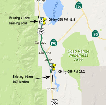 In 2007, the CTC did not recommend funding construction
of the Olancha and Cartago Expressway ($107,600K total cost; $59,000K
requested) from the Corridor Mobility Improvement Account (CMIA). However,
the minutes from the 11/08/2007 meeting of the Inyo County Local
Transportation Commission discussed the five options for US 395's
realignment (either expansion or a movement west). The main problem is the
proximity of the LA Aqueduct.
In 2007, the CTC did not recommend funding construction
of the Olancha and Cartago Expressway ($107,600K total cost; $59,000K
requested) from the Corridor Mobility Improvement Account (CMIA). However,
the minutes from the 11/08/2007 meeting of the Inyo County Local
Transportation Commission discussed the five options for US 395's
realignment (either expansion or a movement west). The main problem is the
proximity of the LA Aqueduct.
In February 2016, it was reported that discussions of
the Olancha Bypass continue. The Caltrans preferred alternative is a
bypass of the community that has Olancha residents in an uproar. Although
the bypass alternative seems to be the much safer option, Olancha
residents don't want to lose the business highway traffic brings into the
already struggling town. Olancha residents claim the bypass alternative is
unfair because the other towns on the US 395 corridor in Inyo country
(Bishop, Big Pine, Independence, Lone Pine) got to keep the highway
running through town. If the bypass alternative is chosen the current
alignment will be turned into a combination of a local road and an
extension of Route 190, a major state route taking year round visitors to
Death Valley National Park. The bypass routing would be to the west, close
to the base of the Sierras, which would give travelers a beautiful view.
The extension of Route 190 would be to the south, through Olancha,
terminating at an intersection with the newly aligned US 395.
(Source: Inyomono395 @ AAroad, February 2016)
In August 2017, the CTC approved for future consideration of funding 09-Iny-395 PM 29.2/41.8 Olancha/Cartago Four-Lane Project: This project in Inyo County will construct two new lanes (one new lane in each direction) on a portion US 395 near the town of Olancha. The project will increase safety and the Level of Service. The project is not fully funded. The project will be funded from State Transportation Improvement Program (STIP) funds and is currently programmed in the 2016 STIP for an estimated $16.6 million Right of Way (capital and support). Construction is estimated to begin in Fiscal Year 2020-21. The scope, as described for the preferred alternative, is consistent with the project scope programmed by the Commission in the 2016 STIP. A copy of the FEIR has been provided to Commission staff. Resources that may be impacted by the project include community impacts, noise, water quality, air quality, cultural resources, paleontological resources, hazardous waste, aesthetics, and biological resources. Potential impacts associated with the project can all be mitigated to below significance. As a result, an FEIR was prepared for the project. Note that this appears to be distinct from the once-proposed Olancha Bypass.
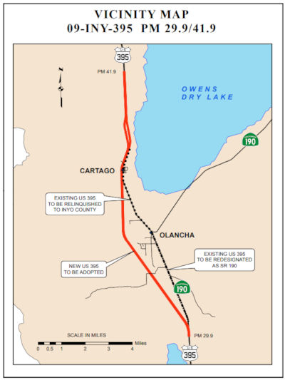 In January 2018, the CTC approved a request from the
California Department of Transportation’s (Department) to adopt US 395 in Inyo County from INY 29.9 to INY 41.9 as a controlled access
highway, redesignate a segment of superseded US 395 as Route 190 and, upon
construction completion of the new controlled access highway, relinquish
the remaining portion of the superseded US 395 to Inyo County. The
Department proposes to adopt this 12.14 mile section of US 395 to
construct a new expressway within the adoption limits, which will improve
safety for the traveling public, raise the level of service, and provide a
continuous four-lane facility in Inyo County. A final Environmental Impact
Report/Environmental Assessment (EIR/EA) prepared pursuant to the
California Environmental Quality Act and the National Environmental Policy
Act was approved by the Department on March 7, 2017 and by the Federal
Highway Administration (FHWA) on May 26, 2017. The Department approved a
project report on June 27, 2017 recommending construction of the new US 395 expressway on a new alignment and redesignation of a portion of the
superseded segment as Route 190. The remaining portion of the superseded
highway will be relinquished to Inyo County after project construction
completion. Later maps indicated that the relinquished section of US 395
may be signed as BUSINESS US 395.
In January 2018, the CTC approved a request from the
California Department of Transportation’s (Department) to adopt US 395 in Inyo County from INY 29.9 to INY 41.9 as a controlled access
highway, redesignate a segment of superseded US 395 as Route 190 and, upon
construction completion of the new controlled access highway, relinquish
the remaining portion of the superseded US 395 to Inyo County. The
Department proposes to adopt this 12.14 mile section of US 395 to
construct a new expressway within the adoption limits, which will improve
safety for the traveling public, raise the level of service, and provide a
continuous four-lane facility in Inyo County. A final Environmental Impact
Report/Environmental Assessment (EIR/EA) prepared pursuant to the
California Environmental Quality Act and the National Environmental Policy
Act was approved by the Department on March 7, 2017 and by the Federal
Highway Administration (FHWA) on May 26, 2017. The Department approved a
project report on June 27, 2017 recommending construction of the new US 395 expressway on a new alignment and redesignation of a portion of the
superseded segment as Route 190. The remaining portion of the superseded
highway will be relinquished to Inyo County after project construction
completion. Later maps indicated that the relinquished section of US 395
may be signed as BUSINESS US 395.
Within the proposed adoption limits, US 395 is currently a two-lane undivided conventional highway. It traverses gently sloping terrain at elevations between 3,600 and 3,900 feet as it passes through the communities of Olancha and Cartago. Olancha is sparsely developed with a few businesses, a post office, and one service station. Cartago is located about three miles north of Olancha and is primarily a residential community. There are a few businesses and residences adjacent to the highway, but in general, the highway corridor is rural in nature. This project will connect the four-lane divided expressway segments at both ends of the adoption limits.
The existing highway generally consists of two 12-foot lanes and 8-foot paved shoulders within 100 feet of right of way. There are no shoulder improvements such as curb, gutter or sidewalk throughout this section of the highway. There is no median and approximately 50 percent of the highway is barrier striped to prevent passing. There are undivided passing lanes for both northbound and southbound traffic north of Cartago. The posted speed limits vary from 65 mph outside of the communities to 55 mph within the communities. In addition to the intersection with Route 190, there are six other public road connections and numerous other private roads and access points to the existing highway within the project limits.
Due to the numerous access points and limited sight distances along US 395, passing zones are limited. There is also a mixture of slower recreational and commercial vehicles, local residential and business traffic, and faster through traffic. The limited passing opportunities and mixed traffic has led to queuing within the communities, driver frustration, and frequent unsafe passing maneuvers. In 2006, shoulders were widened and the posted speed limit reduced within the communities, but the fatal accident rate remained at 1.29 times the statewide average. This section of highway is currently operating at Level of Service (LOS) D and is projected to fall to LOS E within the 20-year planning period.
The proposed route adoption will allow the Department to construct the expressway on a new alignment. It will eliminate traffic congestion and significantly increase safety for the traveling public by separating opposing traffic, removing passing restrictions, and controlling access points. Finally, the new expressway will provide route continuity on US 395 and will complete the construction of four-lanes throughout the US 395 corridor in Inyo County.
A draft project report was approved in September 2010 to evaluate five alternatives. Their environmental impacts were evaluated in an Initial Study/Environmental Assessment circulated end of 2010. Focused studies performed for the preferred alternative determined that mitigation of cultural impacts to insignificant levels may not be possible. As a result, the environmental document was elevated to a Draft Environmental Impact Report/Environmental Assessment (EIR/EA) which allowed the Department to discuss the potential cultural impacts and evaluate the preferred alternative. The Draft EIR/EA was circulated from August to October 2015, after which the preferred alternative was selected.
The portion of the existing highway between the intersection with Route 190 and the southern intersection with the new expressway is proposed to be redesignated as Route 190. A concurrent Commission’s action to approve the redesignation of this portion of US 395 as Route 190 is on the January 2018 Commission agenda. This action will reestablish the terminus of Route 190 at US 395. The remaining portion of the superseded highway between the intersection with Route 190 and north of the community of Cartago will be relinquished to Inyo County after project completion. The superseded highway will continue to provide a local route that preserves the existing uses and access along the existing corridor. The project will also construct or reconstruct a couple other county roads, all of which will be relinquished to Inyo County.
This project has been jointly funded by the Inyo County
Local Transportation Commission, Mono County Local Transportation
Commission, Kern Council of Governments, and the Interregional Improvement
Program. Due to shortfalls in the programming available for the 2016 State
Transportation Improvement Program (STIP), the Construction Capital and
Construction Support components were deprogrammed. Funding for the
Construction Capital and Construction Support components have been
restored in the proposed 2018 STIP. The estimated total cost of the
project, including construction and right of way costs escalated to the
year of construction, is $138,819,000. The project is scheduled to start
construction in September 2020.The Department and Inyo County have agreed
with the public road openings proposed for the new expressway and intend
to execute a Controlled Access Highway Agreement following the
Commission’s approval of this route adoption. Currently, the
Department and Inyo County are negotiating the terms of the relinquishment
agreement. Inyo County has agreed in principle to accept the
relinquishment of the facilities.
(Source: CTC Agenda, January 2018, Agenda Item 2.3a(1))
The 2018 STIP, approved at the CTC March 2018 meeting, appears to restore funding from this, moving the total from $11,420K to $41,487K, including an additional $23,495K in FY21-22, presumably for construction. The project is near Olancha and Cartago, south of the Los Angeles Aqueduct Bridge to south of the Ash Creek Bridge. Widen 2 lane conventional highway to 4 lane expressway. There also appears to be additional funding for this from the Kern and Mono County shares.
In March 2020, the CTC approved the 2020 STIP, which
appears to continue the programmed funding for PPNO 0170 "Olancha-Cartago
4-lane expressway (RIP 25%)" in both Inyo and Kern counties. This funding
includes $17,992K in prior year funding, and 23,495K in FY21-22 for Inyo
and $4,498K in prior year funding and 9,295K in FY21-22 for Kern. It also
included PPNO 0170 Olancha-Cartago 4-lane expressway (IIP 40%), in the
Interregional portion of the STIP with no change in programming: $17,992K
in prior year funding. and $49,615K in FY21-22.
(Source: March 2020 CTC Agenda, Item 4.7, 2020 STIP
Adopted 3/25/2020)
In April 2020, it was reported that Caltrans was in the
final stages of design and right-of-way acquisition for the
Olancha-Cartago 4-Lane project. The project will upgrade 12.6 miles of the
current two-lane highway to a four-lane access-controlled expressway. The
new alignment will begin four miles south of Olancha to four miles north
of Cartago and will close the gap between the existing four-lane sections
to the north and the south. Preconstruction activities include utility
verification and relocation, vegetation removal and/or relocation, staking
the new alignment, installing desert tortoise exclusion fence, and other
various preliminary items. This $83 million-dollar project is jointly
funded by Inyo and Mono Counties’ Local Transportation Commissions,
Kern Council of Governments, and Caltrans with State Transportation
Improvement Program funds. Project completion is tentatively scheduled for
late 2023.
(Source: Sierra Wave Media)
In October 2020, the CTC was given notice of a proposed
amendment to the US 395 – Olancha and Cartago 4-lane Expressway
project in Inyo county (PPNO 0170) (EA 21340/21341) (INY 29.200/41.800),
to separate out a portion of the mitigation work ( $2,920,000 $3,058,000)
into a new project, identified as the Olancha and Cartago Expressway
Desert Tortoise Exclusion Fence project (PPNO 0170B). This project had
extensive and complex environmental challenges, which culminated in
successfully achieving environmental clearance in June 2017, after efforts
for over 10 years, with an Environmental Impact Report/Environmental
Assessment. During the design phase, the archaeological pre-mitigation
work needed to be completed. A separate archaeological pre-mitigation
project for $5,000,000 was programmed for this project, which was
allocated by the Commission in May 2018. In addition, avoidance and
mitigation measures are required to protect the Desert Tortoise. The
avoidance and mitigation fencing are required to be completed prior to
pre-construction activities such as geo-tech investigations, geo-tech
boring, geo-archeology coring, archeological data recovery and utility
relocation. In addition, the fence must be in place prior to commencing
construction activities such clearing and grubbing vegetation, culvert
installation, roadway construction and bridge construction. The funding
for the fencing was identified and budgeted in the Right of Way (R/W)
component. R/W funding for the project was programmed in 2014 and was done
as a lump sum allocation per STIP Guidelines. It had been the standard
practice to execute the construction of the fencing through a service
contract with R/W funds. However, in December 2018, there was a policy
change that no longer allows R/W capital funds to be used in that manner,
and a contract is necessary to construct the fencing requiring the work to
be split and delivered separate from the main project construction. The
Desert Tortoise Exclusion Fence project cost is $2,920,000 $3,058,000.
The proposal is to separate the cost and scope of the fence from the
construction capital of the main project. This separate project would be
able to begin ahead of the major construction contract. With a separate
project to address the fencing, it reduces the risk of delays to the main
project. The current estimated construction capital cost of the main
project remains on budget. The right of way cost estimate for the main
project is currently under budget with potential cost savings to be
reported at time of construction allocation. By having the fencing in
place, allows the construction to proceed without delays. This change to
separate out the fencing cost, from the construction capital, allows the
project to proceed, mitigates the risk of delays since the original
process of implementing as a service is no longer feasible. It should be
noted that the new alignment can be cleared at any time after the fence is
constructed, and the Desert Tortoise fencing would not be the critical
path for the prime contractor. In December 2020, the amendment (with a
corrected amount for the fencing) was voted upon.
(Source: October 2020 CTC Agenda, Agenda Item
2.1b.(1); December 2020 CTC Agenda, Agenda Item 2.1a.(2))
In December 2020, the CTC approved an allocation of
$3,058,000 for the State-Administered STIP Olancha and Cartago Expressway
Desert Tortoise Exclusion Fence project (PPNO 0170B ProjID 0914000036 EA
21341) (INY 29.200/41.800), on the State Highway System, in Inyo County,
programmed in 2021-22. These funds are for installation of Desert Tortoise
Exclusion Fencing.
(Source: December 2020 CTC Agenda, Agenda Item
2.5c.(5))
In May 2021, the CTC approved an allocation of
$92,966,000 for the State-Administered STIP Olancha and Cartago Expressway
project (PPNO 0170), on the State Highway System, in Inyo County,
programmed in 2021-22. The allocation is divided as follows: $83,116,000
from the Budget Act of 2020, Budget Act Items 2660-301-0042 and
2660-301-0890 for construction and $9,850,000 for construction
engineering. Allocation time extensions for other projects programmed
within the current, fiscal year have allowed for sufficient capacity to
become available to fund this advanced project allocation. Details:
09-Iny-395 29.2/41.8. PPNO 09-0170; ProjID 0900000030; EA 21340. Olancha
and Cartago Expressway. US 395 near Olancha and Cartago, south
of the Los Angeles Aqueduct Bridge to south of the Ash Creek Bridge. Widen
2 lane conventional highway to 4 lane expressway. (Future consideration of
funding approved under Resolution E-17-53; August 2017.)
(Source: May 2021 CTC Agenda, Agenda Item 2.5c.(5))
In July 2022, it was reported that ground was broken on
the Olancha-Cartago 4-Lane Project. The Olancha-Cartago 4-Lane Expressway
project will pass west of the town of Olancha and the Los Angeles
Aqueduct. Once the alignment crosses Olancha Creek, the project will cross
the Los Angeles Aqueduct and continue north through Cartago along the
existing highway to meet up with the four-lane section of US 395 to the
north of Cartago. The northbound and southbound lanes will be separated by
a 100-foot unpaved median. As of July 2022, crews were placing rebar on
the footing for the bridge abutments and wingwalls on the south side of
the Los Angeles aqueduct; excavation for the bridge abutments on the south
side of the Los Angeles Aqueduct was completed in June 2022 and excavation
begun for the abutments on the north side. Drainage system installation
continues throughout the project.
(Source: District 9 Project Page, July 2022)
In May 2023, it was reported that workers working on
the Olancha-Cartao project have found buried human remains on the
project's stretch of US 395. These bonds were missed by earlier
archaeological surveys required to start construction of the $69.7-million
Caltrans project to convert 12.6 miles of US 395 from a two-lane road to a
safer four-lane expressway. Tribal leaders say, more than 30 tangled human
skeletons had been unearthed at the site near the Inyo County community of
Cartago, many of them adorned with artifacts: glass beads, abalone shells
and arrowheads. As a result, tribal historic preservation officers are
demanding that the California Department of Transportation halt
construction and realign the project to avoid the gravesites. The project
got off to a rocky start when it was proposed in 1997, with many tribal
leaders warning that nearly every slope, sage plain and shoreline in the
region held evidence of Indigenous people who knew it as a kingdom of
irrigated villages and plentiful game surrounded by canyons and crags
sculpted by storms and flash floods. Caltrans in April offered a proposal
to curve the disputed section of highway around the burial site. But it
wouldn’t move the highway far enough away to satisfy tribal leaders,
who are calling for a clearance of at least half a mile to a mile. The
tribes insist they are not against the highway improvement project. The
problem is that it was approved for construction, they say, without their
consultation. Finally, in mid to late May 2023, Caltrans announced that it
has “halted all construction activities in the area in
question,” including its search for human remains.
(Source: Los Angeles Times, 5/9/2023)
In June 2023, the CTC approved for future consideration
of funding 09-Iny-395, PM 29.2/41.8 Olancha/Cartago Four-Lane Project.
Widen and realign US 395 to four lanes, in Inyo County. (FEIR Addendum)
(PPNO 0170) (STIP). The project is located on US 395 from postmile 29.2 to
postmile 41.8, in Inyo County. The Department proposes to widen a two-lane
conventional highway to a four-lane expressway. The project is currently
programmed in the 2020 STIP for a total of $134,827,000, which includes
Construction (Support and Capital). Construction began 2021-22. The scope,
as described for the preferred alternative, is consistent with the project
scope as programmed by the Commission in the 2020 STIP. A copy of the FEIR
has been provided to Commission staff. The Commission approved the project
for future consideration of funding on August 17, 2017, under Resolution
E-17-53. Since the approval of the 2017 FEIR, CEQA addendums were prepared
to address the modifications to utility relocations, the addition of fiber
optic utility infrastructure as part of the Broadband Middle Mile Network
effort, and the addition of a Global Navigation Satellite System (Real
Time Network) survey station. Additionally, on September 22, 2020, the
western Joshua tree gained protection under CESA as a candidate species to
be listed as threatened or endangered. The Department subsequently
completed Addendums to the FEIR pursuant to CEQA. The Department has
approved this project for construction. This approval and Addendums will
satisfy the environmental requirements for this stage of the planning
process.
(Source: June 2023 CTC Agenda, Agenda Item 2.2c.(2) Item 9)
In June 2023, the CTC approved a request for an
additional $7,800,000 in Construction Support for the STIP Olancha and
Cartago Expressway project on US 395, in Inyo County, to complete the
construction contract. This project (09-Iny-395 29.2/41.8, PPNO 09-0170;
ProjID 0900000030; EA 21340) is located on US 395, in and near Olancha and
Cartago, from south of the Los Angeles Aqueduct Bridge to south of the Ash
Creek Bridge, in Inyo County. The project will convert the two-lane
conventional highway into a four-lane expressway. In March 2012, the
project was programmed for $5,900,000 in Construction Support in the STIP,
$3,103,000 from the Interregional Improvement Program (IIP) and $2,797,000
from the Regional Improvement Program (RIP), for allocation in Fiscal Year
2020-21. In March 2014, the project was amended to increase the programmed
amount to $8,100,000 in Construction Support, $4,260,000 from the IIP and
$3,840,000 from the RIP based on the refinement of the resources needed
when the Project Approval and Environmental Document phase was completed.
In March 2018, the project was further amended to increase the programmed
amount to $9,850,000 in Construction Support, $5,180,000 from the IIP and
$4,670,000 from the RIP, based on the escalation of the resources to the
year of allocation. In May 2021, the project was allocated for $9,850,000
in Construction Support in the STIP, $5,180,000 from the IIP and
$4,670,000 from the RIP. In October 2021, the project was awarded, and
construction began in January 2022, with a planned 500 working days. The
remaining funds are currently at $1,836,000 in Construction Support. The
project is 40 percent complete with 235 working days remaining. The
planned Construction Contract Acceptance is scheduled for August 2024. The
Department is requesting supplemental funds in the amount of $7,800,000 in
Construction Support from the IIP, to complete the construction contract.
Total revised amount $84,310,100.
(Source: June 2023 CTC Agenda, Agenda Item 2.5e.(9))
The project realized cost increases due to
previously undiscovered archeological resources and storm issues that
caused staging delays, regrading of areas, and rework of drainage. These
events and changes have resulted additional work. The project is located
in an environmentally sensitive area for biology and tribal/archeological
resources. Extensive tribal coordination, outreach, and consultation have
been and continue to be conducted throughout project development and
construction. Unanticipated finds of archaeological and tribal cultural
resources, including burials, necessitated additional surveys, monitoring,
treatment, avoidance measures, and security services which increased
costs. These additional resources amount to $2,700,000. Due to the extent
of newly discovered archeological resources, the northbound lanes were
realigned to avoid the resources, resulting in redesign and additional
utility work. These additional resources amount to $900,000. Adding to the
delay were the severe Winter storms in 2023 that caused damage to the
drainage systems and surrounding rough grading and work stoppages,
resulting in delays in critical path items and delaying the project by
three months. An emergency project is underway, under a Director’s
Order, to repair the storm damage that occurred to drainage systems in the
area and on this project. The contractor on this project was brought in to
perform the emergency storm damage repair work. The resource mitigation
and the emergency damage repair work will delay paving and related
construction activities. An additional 175 working days will be needed to
complete the project. This will result in the project being completed in
three construction seasons as opposed to the two seasons that were
originally planned. The project will need additional resources in the
amount of $4,200,000 to complete the remaining activities to close out the
project.
(Source: June 2023 CTC Agenda, Agenda Item 2.5e.(9))
In May 2024, the CTC approved a request for an
additional $33,200,000 (39.9% increase) in Construction Capital and
$5,100,000 (51.8% increase) in Construction Support for the STIP Olancha
and Cartago Expressway project on US 395, in Inyo County. (EA 21340, PPNO
0170). The project had challenges resulting in significant delays due to
extreme weather events, including an exceptionally rare summer storm, an
intense winter season, and Hurricane Hilary. Additionally, archeological
resources encountered surpassed what was anticipated, requiring further
studies, engagement with tribal groups, and adjustments to the road
design. As a result of these challenges, the project needed to reconstruct
drainage systems, regrade the roadway, and undertake additional work,
leading to an increase in the number of working days required to complete
the project. As a result of extreme weather events in 2023 that included
an intense summer storm, Hurricane Hilary, and a very wet winter season,
the project suffered major storm damage. To address damages caused by
these events, the project required additional funding to rework damage to
multiple drainage facilities and reconstruct damaged embankment areas
along the 12.6-mile project limits. In addition, the project is located in
an environmentally sensitive area for biological and tribal/archeological
resources. Extensive tribal coordination, engagement, and consultation
have been and continue to be conducted throughout project development and
construction. Archeological sites were anticipated on the project with a
State Historic Preservation Officer approved treatment plan that was
developed and implemented to handle sites on a case-by-case basis. Site
treatments, when encountered, were developed in coordination with the
Tribal Historic Preservation Officer for the project to determine
avoidance, minimization, and mitigation measures. During roadway
excavation, the sites encountered exceeded what preliminary environmental
studies and exploratory testing anticipated. Due to the extent of
resources encountered during construction, it was determined that exposed
areas required 24/7 tribal security until the sites were mitigated and
protected. The concentration of sites discovered during construction led
to a full work shutdown on a two-mile section of the project from June to
October 2023. Tribal engagement during this period resulted in the
complete redesign of 12 lane-miles of roadway to avoid, minimize, and
mitigate archeological impacts. This work shutdown in the area also
impacted the critical path of the contractor’s work and added
additional delays to the contract. These impacts to construction costs
affected prices for time-related overhead, time delays, lump-sum bid
items, tribal security, and site treatment. It also affected the
quantities for earthwork, aggregate base, hot mix asphalt, drainage
systems, and other time-related impacts due to the delay. These delays and
redesign in construction of the roadway will amount to an increase of
$33,200,000 in capital costs. The number of archeological sites
encountered during construction exceeded what was anticipated following
initial tribal consultations. Additional tribal engagement and
archeological support was required to develop and construct a redesigned
roadway that minimized and/or avoided the archeological resources. Project
delays and the redesign of the roadway to address cultural resources
require an additional 390 working days to complete the project. In
addition, support efforts were and will continue to be required to
identify, protect, and appropriately treat sites, and engage with Tribal
partners. This additional work requires $5,100,000 in support costs to
finish the project. The funding will be used to continue engineering and
construction support activities as described above and to cover
archeological activities due to the increased number of working days.
(Source: May 2024 CTC Agenda, Agenda Item 2.5e.(17))
In October 2024, it was reported that Southbound US 395
traffic would switch onto the new southbound lanes of the Olancha Cartago
4-Lane Expressway Project . With this switch, Caltrans will open a new
road connecting the new southbound lanes to old US 395 and Route 190.
Southbound traffic would use one lane of the new expressway as far as
Crystal Geyser Road, and then would use the full two-lane expressway.
Northbound traffic will remain on the existing lanes of US 395 through
Grant, Olancha, and Cartago, although the segment between US 395 and N
Haiwee Road would be northbound traffic only. A second traffic switch
planned for November 2024 will move northbound traffic to the new
northbound lanes.
(Source: Caltrans, 10/3/2024)
In November 2024, it was reported another switch
occurred. Northbound traffic was switched to the new expressway as far as
Crystal Geyser. Traffic then switched to one of the SB expressway lanes to
Owens Lake Operations Access Road. The segment from N Haiwee Road S to US 395 was closed to both directions; it will likely reopen after the
expressway is completed in 2025 and a new connection with US 395
constructed.
(Source: Caltrans, 11/23/2024)
In December 2024, it was reported that the Route 190
connector within the Olancha-Cartago 4-Lane Expressway Project was open to
the traveling public. Some maps show the connector; however, it is not in
the postmile database as Route 190, nor does it fit the original EIR
proposal. It is unclear if this connector is intended to replace the
section of old US 395 S of Haiwee Road. There have been no changes to the
route adoption previously made, and if the new connector was to be
officially part of Route 190, that would likely require CTC action.
(Source: Caltrans, 12/19/2024)
According to the District 9 PIO, upon completion and
close out of the Olancha-Cartago 4-Lane Project, the postmile database
will be updated to redesignate the Route 190 connector and the stretch of
old US 395 from Route 190 in Olancha to the new connector on the southern
end of the project as Route 190/Business Route 395. The PIO also confirmed that the
stretch of US 395 from the southern connector to the southern end of the
project is being permanently removed.
(Source: Email from Michael Lingberg, District 9 PIO, 1/8/2025)
As of July 2025, the project is nearly done. Old US 395 (presumably now Business Route 395) continues N from Lake Street for a short distance, ending in a cul-de-sac N of Whitney Street. It does not merge back into US 395. On the southern end, Business Route 395 / Route 190 is accessed by a turn off of US 395; the old "veer off" has been abandoned. Going SB on (new) Route 190, the road curves to rejoin US 395. Old US 395, at the point where it split into NB/SB roadways, has been returned to dirt road and blocked off by stones; presumably there is dirt road access for those accessing the labs and ranches in that area. As of July 2025, GSV is disconcerting as it keeps switching between the old and new views of the road.
In October 2025, it was reported that major
construction has been completed on the Olancha-Cartago 4-Lane Expressway
Project. This project constructed 12.5 miles of new pavement, replacing
the previous two-lane highway with a split 4-lane expressway designed to
eliminate cross-centerline crashes. This is the final stretch of US 395 to
be converted into a 4-lane expressway in most of Inyo County. The new
lanes on US 395 closed the gap between existing four-lane sections to the
north and south. The project was initiated in the District 9 Planning
branch in 1998, and studies of possible bypasses in the area go as far
back as the 1960s. Fisher Sand & Gravel started construction on the
project in January 2022, and its crews moved approximately 1.6 million
yards of earth and laid 290,000 tons of fresh asphalt. One of the notable
project features was the use of a temporary rock crusher and asphalt
production plant on-site. It utilized crushed granite harvested from the
ground within the project area to produce roadway base and asphalt. This
method reduced trucking costs associated with transporting material from
long distances, saving time and taxpayer money. The project includes
10’ shoulders; new highway access points at Lake Street, Crystal
Geyser Road, and the Route 190 connector; and a multi-use undercrossing.
Before work on the new lanes started, crews relocated nearly 150 Joshua
trees and several desert tortoises within the project area.
(Source: Ridgecrest Daily Independent, 10/31/2025; Sierra Wave Media, 10/30/2025)
Manzanar Improvements (approx INY 67.69)
In October 2004, the CTC considered adoption of 2.6 kilometers (1.6 miles) of Controlled Access Highway for Route 395 from 2.9 kilometers (1.8 miles) south of Mazourka Canyon Road to 0.3 kilometers (0.2 mile) south of Mazourka Canyon Road in Inyo County. Currently, this segment of Route 395 is a two-lane conventional highway crossing generally level terrain. Cross-section consists of two standard 3.6 m (12 ft) lanes with predominantly non-standard 1.2 m (4 ft ) shoulders, where 3 m (8 ft) is standard. At the southern limit of the adoption, the route will connect to the recently approved Manzanar four-lane divided section (Resolution HRA-04-02 approved August, 2004). This segment south of Independence was not included in the Manzanar adoption, as it was an integral part of a possible Independence bypass alternative and subject to various alignment considerations. This bypass alternative had less than a 3% approval at public hearings and was ultimately rejected for the recently approved 4-lane improvement project through Independence. Current and twenty year projected Level of Service (LOS) for the existing facility is ‘D’, congested. The current and twenty year LOS for the proposed project is ‘A’, free flowing. The majority of the property through which this segment of the route passes is owned by the Los Angeles Department of Water and Power, with little development adjacent to the existing or proposed right of way south of Independence. The route adoption proposes a controlled access highway on predominantly existing alignment from the northern end of the Manzanar four lane section adopted in August, 2004, to a point 0.3 kilometers (0.2 miles) south of Mazourka Canyon Road, at Independence. Construction is currently scheduled for FY 2007-08, based on programming in a 2004 STIP.
The four lane project between Lone Pine and/through Independence is nearly completed as of August 2010. The last portion is around Manzanar where a new bridge is being completed for the southbound alignment; the northbound alignment is pretty much intact. The new alignment in Manzinar leaves a stretch of the old alignment as a frontage road, and the only connection from the new US 395 to the frontage road is at Manzanar Reward Rd. This means all of US 395 from Inyokern to Conway Summit is four-lane expressway except for the piece through Olancha which is unlikely to be upgraded anytime soon. The segment was completed in October 2010.
In January 2011, the CTC vacated right of way in the county of Inyo along Route 395 at the Manzanar National Historic Site, consisting of superseded highway right of way no longer needed for State highway purposes.
In November 2007, it was reported that in Independence (roughly INY
73.35), Caltrans is attempting to widen US 395. However, trees are in the
way, according to an article in the LA Times. Specifically, Caltrans engineers say 100 trees are standing in the way of plans to widen a stretch of the route in
Independence from two to four lanes and line it with about 400 feet of
sidewalks. The project, they say, would improve safety and the flow of
vehicles on the rural fringe of the community. The issue has its roots in
Caltrans' decade-old proposal to widen US 395 to four lanes between
Ridgecrest and Mammoth Mountain. The mile-long stretch, edged with dirt
shoulders, is among the last to be expanded.
(Source: Los Angeles Times, 11/27/2007)
In August 2003, the CTC considered relinquishment of the county road and frontage road portion of Route 395 between PM 90.9 and PM 99.6 (i.e., between South Fish Springs Road and Big Pine Dump Road) in the County of Inyo. Also considered was vacation of the right of way in the County of Inyo, between North Fish Springs Road and 0.25 mi S of the Town of Big Pine, that is a right of way superseded by construction on a new alignment. In September, the CTC considered relinquishment of right of way in the County of Mono (County), at Utility Road (County Road No. 3203), consisting of reconstructed and relocated county road.
Bishop Area (approx INY 115.341) Access and Circulation
![[Bishop Bypasses]](maps/395-bishop.jpg) In 2003 the Inyo County Local Transportation Commission, with the support of the City of Bishop and Inyo
County, requested that Caltrans District 9 conduct a Bishop Area Access
and Circulation Study. This study was published at http://inyoltc.org/pdfs/baacs.pdf. The basic goal was to develop a plan and alternatives to (1) Improve
circulation and safety for all modes of transportation in the downtown
area. (2) Accommodate commercial truck traffic for US 395 and US 6. (3)
Plan for downtown improvements (i.e. landscaping, parking, pedestrian
facilities, etc.) along with the rerouting of truck traffic. (4)
Facilitate ground access improvements to the airport and its associated
development improvements. (4) Keep services in Bishop visible for
through-traffic on any route and have easy on/off connections. The plan
notes that a bypass of the Bishop business district was considered in 1966
(see http://www.ca-bishop.us/Misc/07_1009_BAACS_Appendix.pdf) but traffic didn't justify it; the alternatives from that plan are no
longer practical as the land is either privately owned and developed, or
tribal lands. The basic recommendations of this study (which has not been
adopted yet by the CTC) are:
In 2003 the Inyo County Local Transportation Commission, with the support of the City of Bishop and Inyo
County, requested that Caltrans District 9 conduct a Bishop Area Access
and Circulation Study. This study was published at http://inyoltc.org/pdfs/baacs.pdf. The basic goal was to develop a plan and alternatives to (1) Improve
circulation and safety for all modes of transportation in the downtown
area. (2) Accommodate commercial truck traffic for US 395 and US 6. (3)
Plan for downtown improvements (i.e. landscaping, parking, pedestrian
facilities, etc.) along with the rerouting of truck traffic. (4)
Facilitate ground access improvements to the airport and its associated
development improvements. (4) Keep services in Bishop visible for
through-traffic on any route and have easy on/off connections. The plan
notes that a bypass of the Bishop business district was considered in 1966
(see http://www.ca-bishop.us/Misc/07_1009_BAACS_Appendix.pdf) but traffic didn't justify it; the alternatives from that plan are no
longer practical as the land is either privately owned and developed, or
tribal lands. The basic recommendations of this study (which has not been
adopted yet by the CTC) are:
Some other interim recommendations from the report include: better alignment of the Wye Road/US 6 intersection and the eventual reconfiguration of the US 6/US 395/ Wye Road intersection; the aligning of side streets off of Main Street/US 395 to create at least one more full four way intersection; extending See Vee Lane north of US 395; signalizing the See Vee/US 395 intersection; and defining access along the North Sierra Highway corridor with sidewalks and driveways.
As of May 2009, Cameron Kaiser reports that repaving is taking place on the Sherwin Grade, as well as a big resurfacing project north of the Bishop city limits. The 4-lane project for Inyo is proceeding but in several distinct phases. The first phase from Black Rock to Elna Rd is apparently complete but now they're repaving the original (NB) lanes, so everyone uses the new southbound lanes. The rest area isn't done. There is a second phase from Black Rock to Independence which has some asphalt and grading work on its new NB lanes but is not nearly as complete. Independence's street widening project is in full swing. All of the sidewalks have been torn up and the traffic lanes shifted over while work is done on the original NB side. No paving or concrete yet but the entire new section(s) are fully graded in preparation for moulds. The final phase is from Independence to Lone Pine via Manzanar. This only looks just started; there is only grading existing on the new NB lanes, no asphalt and no bridgework (several of the channels will need culverts or bridges).
N of Bishop to the Nevada State Line
Widening and Slope Flattening near Tom's Place (09-Mono-395 PM 6.9/9.6)
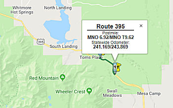 In October 2018, the CTC approved for for future consideration of funding the
following project for which a Mitigated Negative Declaration (MND) has
been completed: US 395 in Mono County (09-Mno-395, PM 6.92/9.62). Widen
existing shoulders on a portion of US 395 in Mono County. (PPNO 0662) This
project is located on US 395 between Bishop and Toms Place in Mono County.
The project proposes to widen the existing paved highway shoulders at the
project location. The proposed project addresses the need to reduce the
number and severity of collisions and enhance safety. Also included in the
proposed project will be added rumble strips, replacement of guardrails,
upgrading of drainage systems, modification to slopes for improvement in
sight distances around curves and additions to bicycle right turn lanes.
The proposed project is currently estimated to cost approximately $22.5
million. This project is fully funded and is currently programmed in the
2018 SHOPP for approximately $20.4 million which includes Construction
(capital and support) and Right-of-Way (capital and support). Construction
is estimated to begin in Fiscal Year 2020-21. The scope, as described for
the preferred alternative, is consistent with the project scope programmed
by the Commission in the 2018 SHOPP.
In October 2018, the CTC approved for for future consideration of funding the
following project for which a Mitigated Negative Declaration (MND) has
been completed: US 395 in Mono County (09-Mno-395, PM 6.92/9.62). Widen
existing shoulders on a portion of US 395 in Mono County. (PPNO 0662) This
project is located on US 395 between Bishop and Toms Place in Mono County.
The project proposes to widen the existing paved highway shoulders at the
project location. The proposed project addresses the need to reduce the
number and severity of collisions and enhance safety. Also included in the
proposed project will be added rumble strips, replacement of guardrails,
upgrading of drainage systems, modification to slopes for improvement in
sight distances around curves and additions to bicycle right turn lanes.
The proposed project is currently estimated to cost approximately $22.5
million. This project is fully funded and is currently programmed in the
2018 SHOPP for approximately $20.4 million which includes Construction
(capital and support) and Right-of-Way (capital and support). Construction
is estimated to begin in Fiscal Year 2020-21. The scope, as described for
the preferred alternative, is consistent with the project scope programmed
by the Commission in the 2018 SHOPP.
(Source: October 2018 CTC Agenda Item 2.2c.(1))
The 2020 SHOPP, approved in May 2020, included the
following Collision Reduction item of interest (carried over from the 2018
SHOPP): 09-Mono-395 PM 6.9/9.6 PPNO 0662 Proj ID 0914000003 EA 36070. US 395 near Tom's Place, from 2.4 miles south of Lower Rock Creek Road to 0.3
mile north of Lower Rock Creek Road. Widen shoulders, flatten slopes,
install ground in rumble strips, reconstruct and install guardrail.
Programmed in FY20-21, with construction scheduled to start in November
2020. Total project cost is $22,451K, with $16,208K being capital (const
and right of way) and $6,243K being support (engineering, environmental,
etc.).
(Source: 2020 Approved SHOPP a/o May 2020)
In October 2020, the CTC approved the following SHOPP
Construction Phase allocation: $17,610,000 for Mono 09-Mno-395 PM
R6.9/T9.6. PPNO 09-0662 ProjID 0914000003 EA 36070. US 395 Near Tom's
Place, from 2.4 miles south of Lower Rock Creek Road to 0.3 mile north of
Lower Rock Creek Road. Outcome/Output: Reduce the number and
severity of collisions by widening shoulders, flattening slopes,
installing rumble strips, and reconstructing and installing guardrail. Con
Eng $2,799,000; Const $15,840,000. (CEQA - MND, 7/24/2018; Re-validation
7/27/2020) (NEPA - FONSI, 7/24/2018; Re-validation 7/27/2020) (Future
consideration of funding approved under Resolution E-18-130; October
2018.)
(Source: October 2020 CTC Agenda, Agenda Item
2.5b.(1) #21)
In May 2019, the CTC approved for future consideration of funding a
project located on US 395 between the towns of Mammoth and June Lake
(09-Mno-395, PM 30.7 & 36.5), in Mono County. The project proposes to
pave three locations to provide off-highway parking to access hiking,
bicycle and snowmobile trails along US 395. The project addresses the need
to provide winter access parking for recreations users and to avoid
parking on highway shoulders creating potential hazard for snow plowing
and motorists. The proposed project has been developed and studied in
conjunction with the US Forest Service-Inyo National Forest. The estimated
total overall cost of the project is $1.6 million. The project is not
currently programmed in the SHOPP. The project is estimated to begin in
Fiscal Year 2020-21.
(Source: May 2019 CTC Minutes, Agenda Item
2.2c.(1))
In August 2015, the CTC authorized vacation of right of way in the county of Mono along Route 395 at Material Site Number 190, approximately 0.8 mile north of Route 120 (approx MNO 51.595), consisting of highway right of way (a material site) no longer needed for State highway purposes. The site will revert to the Bureau of Land Management.
Conway Ranch Shoulder Widening Project (09-Mono-395 PM 58.2/60.4)
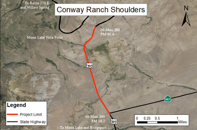 The 2020 SHOPP, approved in May 2020, included the following Collision Reduction
item of interest (carried over from the 2018 SHOPP): 09-Mono-395 PM
58.2/60.2 PPNO 2624 Proj ID 0916000006 EA 36640. US 395 near Lee Vining,
from Route 167 Junction to 0.2 mile north of Conway Ranch Road. Widen
shoulders, install shoulder rumble strip, correct compound curve, and
improve chain control area. Programmed in FY21-22, with construction
scheduled to start in January 2023. Total project cost is $9,376K, with
$5,996K being capital (const and right of way) and $3,380K being support
(engineering, environmental, etc.).
The 2020 SHOPP, approved in May 2020, included the following Collision Reduction
item of interest (carried over from the 2018 SHOPP): 09-Mono-395 PM
58.2/60.2 PPNO 2624 Proj ID 0916000006 EA 36640. US 395 near Lee Vining,
from Route 167 Junction to 0.2 mile north of Conway Ranch Road. Widen
shoulders, install shoulder rumble strip, correct compound curve, and
improve chain control area. Programmed in FY21-22, with construction
scheduled to start in January 2023. Total project cost is $9,376K, with
$5,996K being capital (const and right of way) and $3,380K being support
(engineering, environmental, etc.).
(Source: 2020 Approved SHOPP a/o May 2020)
In August 2020, the CTC approved the following
financial allocation: $830,000 for PS&E; $590,000 for R/W Support.
09-Mno-395 PM 58.2/60.2. PPNO 2624 ProjID 0916000006 EA 36640. US 395 Near
Lee Vining, from Route 167 Junction to 0.2 mile north of Conway Ranch
Road. Widen shoulders, install shoulder rumble strip, correct compound
curve, and improve chain control area.
(Source: August 2020 CTC Agenda, Agenda Item
2.5b.(2a) #28)
In May 2021, the CTC amended this project in the SHOPP:
(1d) #51. 09-Mno-395 58.2/60.2 58.2/60.4 PPNO 2624
ProjID 0916000006 EA 36640. US 395 Near Lee Vining, from Route 167
Junction to 0.2 0.4 mile north of Conway Ranch
Road. Widen shoulders, install shoulder rumble strip, correct compound
curve, and improve chain control area. Amended to update description and
postmiles to extend the project limits to correct an existing compound
curve by removing and replacing striping.
(Source: May 2021 CTC Agenda, Agenda Item 2.1a.(1d)
#51)
In November 2021, it was reported that Caltrans
District 9 was seeking public comment on the proposed Conway Ranch
Shoulders Project. The Conway Ranch Shoulder Widening project proposes to
widen the existing paved shoulders on US 395 from the junction with Route 167 to 0.4 miles north of Conway Ranch Road in Mono County. It also
proposes to install shoulder rumble strips, correct a substandard compound
curve and lengthen the chain control area at postmile 59.2 by 500 feet.
Culverts will be extended or replaced as needed. There one build and one
no-build alternative under consideration for the project. The proposed
features of the Build Alternative are the following: (•) Existing
alignment, shoulder widening to both sides; (•) Eight-foot wide
outside shoulders; shoulder ground-in skip rumble strips; (•)
Lengthen the existing northbound chain installation/removal area at
postmile 59.20 to postmile 59.28 to the south 500 feet; (•) Install
switch controlled lighting at chain installation/removal area; (•)
Curve correction restripe; (•) Where required, fill slopes to 4:1 or
flatter fill to the clear recover zone; (•) From edge of the clear
recovery zone, variable fill slope to edge of Right of Way; (•)
Correct clear recovery zone slope and hit object conditions; (•)
Guard rail at select locations; (•) Extend culverts; and (•)
Erosion control, reclaim and revegetate.
(Source: Caltrans District 9 on Twitter, 11/5/2021; Caltrans Project Page)
In March 2023, the CTC approved an additional
$2,508,000 in Construction Capital for the SHOPP Collision Severity
Reduction project on US 395, in Mono County, to award the construction
contract. This project is located on US 395 near Lee Vining, from the
Route 167 junction to north of Conway Ranch Road, in Mono County. The
project will widen shoulders, install shoulder rumble strip, perform curve
correction work, and improve chain control areas. In October 2022, the
Department advertised the contract and held bid opening in November 2022.
The contract received four bids, of which the lowest bid is 21.4 percent
above the Engineer’s Estimate (EE), however the bidder was found to
be non-responsive. The second lowest bid is 45.3 percent over the EE, and
the two remaining bids are 62.6 and 119.6 percent over the EE. As evident
by the latest market trends, current prices have risen significantly due
to fluctuations in the economy, supply chain shortages, and oil costs. As
a result, there are increases, above the EE, for pipe culvert structural
concrete, traffic control, electrical, and hot mix asphalt items. In
addition, due to the remoteness of the project’s location, the
sub-contractor’s prices came in even higher than anticipated. The
remoteness also affected the costs associated with traffic control and
electrical items as contractors have seen a decrease in the number of
participating subcontractors. The contractors have also cited higher
trucking costs to deliver the imported material and temporary barrier
system to the job site. The temporary creek diversion systems item also
has a cost increase due to the difference in the contractor’s means
and methods and the unknown risk that was accounted for, to prepare the
site, prior to installing the diversion system.
(Source: March 2023 CTC Agenda, Agenda Item 2.5e.(11))
In May 2024, it was reported that the Conway Ranch
Shoulders Project would emerge from its winter suspension. This project,
which began construction in spring 2023 before going into winter
suspension in November 2023, is implementing safety improvements to US 395
between Route 167 and north of Conway Ranch Road. The primary focus of the
project is to improve safety for motorists by widening the embankment and
shoulders to eight feet and creating more space for drivers on the side of
the road. Other safety improvements included in this project: (1) Addition
of 12-inch rumble strips: Also known as “sleeper lines,” these
road safety features alert inattentive drivers of potential risks by
causing a vibration and audible rumbling transmitted through the wheels
and into the vehicle interior. Rumble strips can prevent drivers from
crossing the centerline or veering into another lane. (2) One half mile
extension of the northbound chain-up area: Additional space will
accommodate more motorists waiting to put chains on their vehicles. The
increased space for chain installation will help return more cards to the
roadway that are properly equipped to navigate winter weather conditions.
(3) New lighting systems in the extended chain-up area will increase
visibility for people installing chains and make it easier for passing
vehicles to see the chain-up area. (4) Replacement of culverts and traffic
signs.
(Source: Caltrans 5/9/2024)
In June 2024, the CTC approved a request for an
additional $700,000 (8.4% increase) in Construction Capital for the SHOPP
Collision Severity Reduction project on US 395, in Mono County. (EA 36640,
PPNO 2624). This project is located on US 395 near Lee Vining, from the
Route 167 junction to north of Conway Ranch Road, in Mono County. The
project will widen the shoulders to the standard width, install shoulder
rumble strip, rehabilitate drainage systems, perform curve correction
work, and improve a chain control area. In March 2018, the project was
programmed for $5,490,000 in Construction Capital and $1,440,000 in
Construction Support in the SHOPP for allocation in Fiscal Year 2021-22.
In June 2022, the project received a six-month time extension to allocate
the Construction phase. In August 2022, the project was allocated for
$5,792,000 in Construction Capital and $1,440,000 in Construction Support.
In March 2023, the project received a six-month time extension to award
the Construction phase. The project also received supplemental funds in
the amount of $2,508,000 in Construction Capital to award the contract. In
April 2023, the project was awarded for $8,296,000 in Construction
Capital, and construction began in June 2023 with 140 working days planned
to construct the project. In April 2024, the project received G-12 funds
in the amount of $340,000 for Construction Support. The remaining funds
are currently at $4,046,000 in Construction Capital and $626,000 in
Construction Support. The project is 70 percent complete with 40 working
days remaining. The planned Construction Contract Acceptance is scheduled
for October 2024. The project realized cost increases due to complicated
construction of culvert work as a result of differing site conditions, and
a discrepancy between the survey data and 3-D modeling. This led to the
redesign of earthwork and drainage appurtenances. The historic snowfall in
the Winter of 2022/23 led to massive run-off of snow melt during the
Summer of 2023 filling the drainage channels that are typically dry during
this time of the year. As a result, the site conditions differed and
complicated the construction of the drainage systems. At one culvert
location, construction of two drainage system headwalls required extensive
excavation and dewatering due to issues encountered with the presence of
water in the drainage channels. Dewatering was not identified on the plans
as in normal snow fall years, the drainage channels would have been dry.
Also, during construction, several unidentified buried culverts and under
drain systems were encountered during clearing and preparing the ground
surface prior to shoulder widening work. These culverts were extended to
conform to the new ground surface of the shoulder widening. During
construction survey staking, the earthwork was found to not align with the
proposed plans. The Department evaluated the issue and determined that the
proposed roadway centerline included a two-foot offset that was not
accounted for in the design. This led to a redesign of the earthwork and
side slopes. As a result of the earthwork changes, adjustments to the
proposed headwalls and other drainage appurtenances had to be redesigned
to be outside of the clear recovery zone. This affected three drainage
structures.
(Source: June 2024 CTC Agenda, Agenda Item 2.5e.(13))
In May 2019, the CTC deleted the long-lead project 09-Mno-395 69.9/71.9.
PPNO 2639. Proj ID 0917000014. On US 395 Near Bridgeport, from north
of Route 270 Junction to Green Creek Road. Widen shoulders to eight
feet, install rumble strips, improve sight distance, and upgrade signing
and striping to current standards . Remove project from the Long
Lead list and develop a Minor project to install rumble strips.
(Source: May 2019 CTC Agenda Item 2.1a.(1) Item
LL#2)
In May 2015, the CTC approved for future consideration of funding a project in Mono County that will widen the paved shoulders on a portion of US 395 near the town of Bridgeport (approx MNO 75.846). The project is programmed in the 2014 State Highway Operation and Protection Program. The estimated cost is $16,574,000 for capital and support. Construction is estimated to begin in Fiscal Year 2016-17. The scope, as described for the preferred alternative, is consistent with the project scope programmed by the Commission in the 2014 State Highway Operation and Protection Program.
Aspen Fales Shoulder Widening Project (09-Mno-395 PM 88.42/91.55)
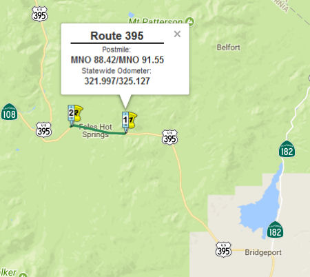 In August 2017, the CTC approved for future consideration
of funding 09-Mno-395 PM 88.42/91.55 Aspen Fales Shoulder Widening
Project: This project in Mono County will widen shoulders on US 395 in the
town of Bridgeport. The project will improve safety and operations for the
traveling public. The project will be funded from State Highway Operation
and Protection Program (SHOPP) funds and is programmed in the 2016 SHOPP
for an estimated $14.2 million Construction (capital and support) and
Right of Way (capital and support). Construction is estimated to begin in
Fiscal Year 2018-19. The scope, as described for the preferred
alternative, is consistent with the project scope programmed by the
Commission in the 2016 SHOPP. A copy of the FEIR has been provided to
Commission staff. Resources that may be impacted by the project include
visual and aesthetics, cultural resources, noise, and biological
resources. Potential impacts associated with the project can all be
mitigated to below significance. As a result, an FEIR was prepared for the
project.
In August 2017, the CTC approved for future consideration
of funding 09-Mno-395 PM 88.42/91.55 Aspen Fales Shoulder Widening
Project: This project in Mono County will widen shoulders on US 395 in the
town of Bridgeport. The project will improve safety and operations for the
traveling public. The project will be funded from State Highway Operation
and Protection Program (SHOPP) funds and is programmed in the 2016 SHOPP
for an estimated $14.2 million Construction (capital and support) and
Right of Way (capital and support). Construction is estimated to begin in
Fiscal Year 2018-19. The scope, as described for the preferred
alternative, is consistent with the project scope programmed by the
Commission in the 2016 SHOPP. A copy of the FEIR has been provided to
Commission staff. Resources that may be impacted by the project include
visual and aesthetics, cultural resources, noise, and biological
resources. Potential impacts associated with the project can all be
mitigated to below significance. As a result, an FEIR was prepared for the
project.
In January 2019, the CTC approved the following
allocation: $9,555,000 Mono 09-Mno-395 88.4/91.6. US 395 Near Bridgeport,
from north of Devils Gate Summit to Burcham Flat Road. Outcome/Output:
Widen shoulders and construct rumble strip. This project will reduce the
number and severity of collisions. Future consideration of funding
approved under Resolution E-17-54; August 2017. Related supplemental funds
vote to re-advertise EA 35780/PPNO 09-0615 under Ref. 2.5e.(2), Resolution
FA-18-36.
(Source: January 2019 CTC Minutes, Agenda Item
2.5b.(1) Item 21)
In July 2019, Caltrans began holding preliminary
meetings on the Aspen-Walker Shoulder Widening Project, which will widen
the highway shoulders from the existing width of 2-3 feet to 8 feet, as
well as construct retaining walls and install rumble strips. The project
will run along US 395 from 5 miles south of Sonora Junction at State Route 108 to 2 miles north of the junction (~ MNO 88.765/MNO 95.765).
(Source: Record Courier, 7/13/2019)
Sonora Junction Shoulders Project (09-Mno-395, PM 91.6/93.4)
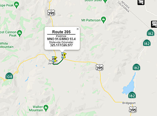 In January 2019, the CTC approved a request for an
additional $2,985,000 for the State Highway Operation Protection Program
(SHOPP) Collision Severity Reduction project (PPNO 0615) on US 395, in
Mono County, to re-advertise the construction contract. This project is
located on US 395, near the town of Bridgeport, in Mono County (09-Mno-395
93.4/95.7). The project will widen shoulders, install rumble strips,
replace and upgrade guardrails, install new concrete barriers, improve
roadway cross-slope and stopping sight distance, and install rock-fall
protection to reduce the severity and number of collisions. The
performance measure goal is to reduce collisions by 28 collisions and
improve 2.9 lane miles from “fair” to “good”
condition and improve one census station from “poor” to
“good” condition. The improvement is consistent with the
Commission-adopted goals and objectives of the Transportation Asset
Management Plan. As of January 2019, all contract bids have been rejected.
The Department will re-advertise the contract upon approval of this
supplemental funds request. The updated certified Engineers Estimate and
adjusted project cost is expected to attract more bidders when the project
is re-advertised in February 2019 if this supplemental fund request is
approved. Over the last half year, the Department has seen a trend that
shows a significant increase in the cost of materials and significant
decrease of available contractors and subcontractors in a busy
construction market. Based on the discussion with several non-bidding
contractors, the Department believes that readvertising the project is in
the best interest of the State, as the Department is combining this
project with the Aspen Fales Shoulder Widening Project, for construction.
This will help decrease the overall costs and allow the contractor to
control the entire operations of both projects, therefore eliminate
dueling prime contractors and subcontractors working adjacent to each
other. The Department will also perform contractors outreach events during
the advertisement period. The Department will also make available a site
near the city of Lee Vining for contractors use as the Baseline Material
Site. In addition, both projects to the north and south, have since been
completed so the project is no longer “land-locked” between
ongoing construction or competing contractors. Based on conversations with
those non-bidding contractors, this could also provide a more favorable
bidding environment upon re-advertising the project.
In January 2019, the CTC approved a request for an
additional $2,985,000 for the State Highway Operation Protection Program
(SHOPP) Collision Severity Reduction project (PPNO 0615) on US 395, in
Mono County, to re-advertise the construction contract. This project is
located on US 395, near the town of Bridgeport, in Mono County (09-Mno-395
93.4/95.7). The project will widen shoulders, install rumble strips,
replace and upgrade guardrails, install new concrete barriers, improve
roadway cross-slope and stopping sight distance, and install rock-fall
protection to reduce the severity and number of collisions. The
performance measure goal is to reduce collisions by 28 collisions and
improve 2.9 lane miles from “fair” to “good”
condition and improve one census station from “poor” to
“good” condition. The improvement is consistent with the
Commission-adopted goals and objectives of the Transportation Asset
Management Plan. As of January 2019, all contract bids have been rejected.
The Department will re-advertise the contract upon approval of this
supplemental funds request. The updated certified Engineers Estimate and
adjusted project cost is expected to attract more bidders when the project
is re-advertised in February 2019 if this supplemental fund request is
approved. Over the last half year, the Department has seen a trend that
shows a significant increase in the cost of materials and significant
decrease of available contractors and subcontractors in a busy
construction market. Based on the discussion with several non-bidding
contractors, the Department believes that readvertising the project is in
the best interest of the State, as the Department is combining this
project with the Aspen Fales Shoulder Widening Project, for construction.
This will help decrease the overall costs and allow the contractor to
control the entire operations of both projects, therefore eliminate
dueling prime contractors and subcontractors working adjacent to each
other. The Department will also perform contractors outreach events during
the advertisement period. The Department will also make available a site
near the city of Lee Vining for contractors use as the Baseline Material
Site. In addition, both projects to the north and south, have since been
completed so the project is no longer “land-locked” between
ongoing construction or competing contractors. Based on conversations with
those non-bidding contractors, this could also provide a more favorable
bidding environment upon re-advertising the project.
(Source: January 2019 CTC Minutes, Agenda Item 2.5e(2))
The 2020 SHOPP, approved in May 2020, included the
following Collision Reduction item of interest (carried over from the 2018
SHOPP): 09-Mono-395 PM 91.6/93.4 PPNO 2460 Proj ID 0917000011 EA 36800. US 395 near Bridgeport, from Burcham Flat Road to 0.3 mile south of Route 395/Route 108 Junction. Widen shoulders, install rumble strips, and
correct superelevation at three curves. Programmed in FY22-23, with
construction scheduled to start in December 2023. Total project cost is
$20,060K, with $14,422K being capital (const and right of way) and $5,638K
being support (engineering, environmental, etc.).
(Source: 2020 Approved SHOPP a/o May 2020)
In August 2021, the CTC approved the following project
for future consideration of funding: 09-Mno-395, PM 91.6/93.4. Sonora
Junction Shoulders Project. Widen paved highway shoulders, correct
the super- elevation of three curves, add rumble strips, replace
guardrails, and rehabilitate pavement on US 395 in Mono County. (MND)
(PPNO 2460) (SHOPP). This project is located on US 395 from post mile 91.6
to 93.4, in Mono County. The Department proposes to construct 8-foot
shoulders on both the northbound and southbound sides of the highway
throughout the project limits. In addition, deer exclusion fencing and two
wildlife undercrossing structures will be constructed. This project is
currently programmed in the 2020 SHOPP for a total of $20,060,000, which
includes Construction (capital and support) and Right of Way (support).
Construction is estimated to begin in 2023-24. The scope, as described for
the preferred alternative, is consistent with the project scope as
programmed by the Commission in the 2020 SHOPP. A copy of the MND has been
provided to Commission staff. The project will result in less than
significant impacts to the environment after mitigation. The following
resource areas may be impacted by the project: biological resources.
Avoidance and minimization measures will reduce any potential effects on
the environment. These measures include, but are not limited to,
purchasing credits from a mitigation bank or by paying into an in-lieu fee
program to mitigate permanent impacts to waters and riparian vegetation.
As a result, an MND was completed for this project.
(Source: August 2021 CTC Agenda, Agenda Item
2.2c.(1))
Also in August 2021, the CTC approved the following
preconstruction allocation: 09-Mno-395 91.6/93.4. PPNO 09-2460; ProjID
0917000011; EA 36800. US 395 Near Bridgeport, from Burcham Flat Road to
0.3 mile south of Route 395/108 Junction. Widen shoulders, install rumble
strips, and correct superelevation at three curves. (Concurrent
consideration of funding under Resolution E-21-87; August 2021.)
Allocation: PS&E $1,764,000; R/W Sup $395,000.
(Source: August 2021 CTC Agenda, Agenda Item
2.5b.(2a) #16)
 In June 2022, the CTC amended this project in the SHOPP
as follows: 09-Mno-395 91.6/93.4. PPNO 09-2460; ProjID 0917000011; EA
36800. US 395 Near Bridgeport, from Burcham Flat Road to 0.3 mile south of
Route 108
In June 2022, the CTC amended this project in the SHOPP
as follows: 09-Mno-395 91.6/93.4. PPNO 09-2460; ProjID 0917000011; EA
36800. US 395 Near Bridgeport, from Burcham Flat Road to 0.3 mile south of
Route 108 395/108 Junction. Widen shoulders,
install rumble strips, install wildlife crossing and fencing
and correct superelevation at three curves. Note: Add wildlife crossing
and fencing scope to project and description, which increases construction
capital. Decrease R/W capital due to reduced environmental impacts,
resulting in lower mitigation costs. Also, increases in unit cost of
asphalt and in quantities of import borrow material and a required
temporary realignment results in additional construction capital cost
increases. Amendments ($ × 1,000): R/W Cap $1,855 ⇒ $1,366;
Const Cap $12,567 ⇒ $16,854; TOTAL $20,060 ⇒ $23,858.
(Source: June 2022 CTC Agenda, Agenda Item
2.1a.(1d) #78)
In October 2023, the CTC approved for consideration of
funding the following project for which a MND and an Addendum have been
completed: US 395 in Mono County. Construct 8-foot shoulders on both sides
of US 395, and construct deer exclusion fencing and two wildlife
undercrossing structures, in Mono County. (09-Mno-395, PM 91.6/93.4; PPNO
2460). The project is currently programmed in the 2022 SHOPP for a total
of $23,858,000, which includes Right of Way (Support and Capital) and
Construction (Support and Capital). Construction began in 2023-24. The
scope, as described for the preferred alternative, is consistent with the
project scope as programmed by the Commission in the 2022 SHOPP. A copy of
the MND has been provided to Commission staff. The Commission approved the
project for future consideration of funding on August 18, 2021, under
Resolution E-21-87. Since the approval of the MND, there have been changes
to the project and an Addendum was prepared pursuant to CEQA. These
changes include the need to drill up to 8 borings as part of a subsurface
exploration program to characterize the existing subsurface conditions to
provide geotechnical information for the design of retaining walls, animal
under crossings, shoulder widening, and cut/fill slopes. The work involved
did not have the potential to result in a new significant environmental
effect or a substantial increase in the severity of a previously
identified significant effect disclosed in the MND. No substantial changes
have occurred with respect to the project circumstances or effects,
severity of effects, alternatives, or mitigation measures. The project
changes do not meet the criteria outlined in CEQA Guidelines Section 15162
to prepare a Subsequent MND. The Department subsequently completed an
Addendum to the MND pursuant to CEQA. The Department has approved this
project for construction. This approval and the Addendum will satisfy the
environmental requirements for this stage of the planning process.
(Source: October 2023 CTC Agenda, Agenda Item 2.2c.(4))
In October 2023, the CTC approved the following
allocation for a SHOPP Project: $18,754,000. 09-Mno-395 91.6/93.4. PPNO
09-2460; ProjID 0917000011; EA 36800. US 395 Near Bridgeport, from Burcham
Flat Road to 0.3 mile south of Route 108. Outcome/Output: Reduce the
number and severity of collisions by widening shoulders, installing rumble
strips, wildlife crossing and fencing, and correcting roadway cross slope
at three curves. CEQA - MND, 5/28/2021; Re-validation 6/22/2023. NEPA -
FONSI, 5/28/2021; Re-validation 6/22/2023. Future consideration of funding
approved under Resolution E-21-87; August 2021. Seven month allocation
time extension for CONST and CON ENG approved under Waiver 23-72; June
2023. Concurrent Amendment under SHOPP Amendment 22H-012; October 2023.
Concurrent addendum for the previously approved Future Consideration of
Funding under Resolution E-23-136A; October 2023. Allocation: CON ENG
$2,084,000; CONST $16,854,000.
(Source: October 2023 CTC Agenda, Agenda Item 2.5b.(1) #13)
In August 2024, it was reported that Caltrans has
announced that US 395 was closing between Bridgeport and Route 108,
starting Sept. 4, 2024 for two weeks. The impacted stretch is nearly 17
miles between Bridgeport and Sonora Junction. The detour forces drivers to
circumvent the project by taking NV 338 to reconnect with US 395 near
Topaz Lake. This is in support of the Sonora Junction Shoulder Widening
Project, which widens the shoulders on US 395 in Mono County, installs
rumble strips, upgrades guardrails and corrects three curves on the road.
It also installs a pair of wildlife undercrossings in two sections on US 395, along with wildlife fencing. Crews are tunneling under the highway
using “plate pipe” archways that are over 70 feet long and as
high as 11 feet. The two culverts will usher animals away from traffic on
395, which Caltrans said in a news release was a “crossing hotspot
for the West Walker herd of mule deer.” Between 2002 and 2024, there
have been 69 reported wildlife collisions on the highway, with likely many
more collisions unreported.
(Source: SF Gate, 8/7/2024)
On September 20, 2024, it was reported that US 395 has
reopened between Burcham Flat Road and Route 108 north of Bridgeport after
crews installed two wildlife crossings as part of the Sonora Junction
Shoulders Project. The highway shut down on September 4, allowing crews to
completely dig up the road for each archway under crossing measuring more
than 70 feet in length and standing between 9.5 feet and 11 feet tall. The
project began construction in May to widen the shoulders of the highway to
8 feet, install rail-element retaining walls, and stabilize slopes with
anchored mesh in addition to installing the wildlife crossings. The full
closure was necessary to allow for the wildlife crossing installations,
and to replace the asphalt concrete and roadway base of US 395 through the
project area as well as shift the centerline of the roadway by up to two
feet in certain locations to accommodate the wider 8-foot shoulders. This
allowed Papich Construction to quickly and safely remove the asphalt and
roadway base to install the under crossings while changing the layout of
the road. Though crews will finish paving and striping through the project
area in 2024, the project is anticipated to enter a winter suspension in
October 2024. Once work resumes in spring 2025, crews will complete
permanent striping of the pavement, erect the wildlife fencing, replace
signs, and upgrade guardrail.
(Source: Sierra Wave, 9/20/2024)
In June 2023, the CTC amended the following project into the 2022 SHOPP:
09-Mno-395 118.4/118.8. PPNO 09-2709; ProjID 0923000047; EA 39930. US 395
Near Topaz, from 2.1 miles to 1.7 miles south of the Nevada State line.
Shift the alignment to the west and cut back the failing slope and install
a rock drapery netting. Note: A slip-out of the embankment under
the northbound lane was discovered on March 19, 2023, creating a crevice 6
to 12 inches wide and 300 feet long in the shoulder and traveled way.
Additional cracks were found in the unpaved shoulder. The lane was
immediately closed and traffic was limited to reversible one-way traffic
control. This project will set up an automatic traffic control signal
system, cut back the slope, install rock drapery netting on the cut slope,
and shift the roadway alignment to the west, away from the slip plane and
onto a stable foundation. Allocation ($ × 1,000): PA&ED $0;
PS&E $0; R/W Sup $100; Con Sup $750; R/W Cap $100; Const Cap $7,500;
TOTAL $8,450. FY22-23.
(Source: June 2023 CTC Agenda, Agenda Item 2.1a.(1a) #51)
 Naming
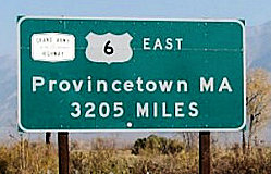 The portion of this route that was cosigned with US 6 (i.e., from Route 14 to US 6 in Bishop
(~ KER 26.958 to INY 114.898) was named the "Grand Army of the Republic
Highway" by Assembly Concurrent Resolution 33, Chapter 73, in 1943.
According to CalTrans in March 1994, the Grand Army route is now US 6,
then US 395 to Route 14, Route 14 to I-5, I-5 to I-110, and then south to
San Pedro. A monument marking the western terminus of the Grand Army
Highway may be found on the wall on the S side of Ocean Avenue, in front
of the Terrace Theatre.
The portion of this route that was cosigned with US 6 (i.e., from Route 14 to US 6 in Bishop
(~ KER 26.958 to INY 114.898) was named the "Grand Army of the Republic
Highway" by Assembly Concurrent Resolution 33, Chapter 73, in 1943.
According to CalTrans in March 1994, the Grand Army route is now US 6,
then US 395 to Route 14, Route 14 to I-5, I-5 to I-110, and then south to
San Pedro. A monument marking the western terminus of the Grand Army
Highway may be found on the wall on the S side of Ocean Avenue, in front
of the Terrace Theatre.
(Image Source: Clamshack on Flikr)
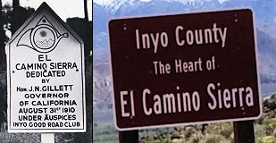 Historically, the portion of this route from Route 14 to
Bridgeport (~ KER 26.958 to MNO 76.758) was part of "El Camino Sierra"
(Road to the Mountains). El Camino Sierra is the name given to US 395 and
the southern portion of US 6 by the Bishop based, Inyo Good Road Club back
in 1910. The name was part of a marketing plan to draw the attention of
Sacramento politicians and highway department officials to this lightly
populated area of the state, in order to obtain a share of the first state
highway construction bond, to build new roads in Inyo and Mono counties.
Historically, the portion of this route from Route 14 to
Bridgeport (~ KER 26.958 to MNO 76.758) was part of "El Camino Sierra"
(Road to the Mountains). El Camino Sierra is the name given to US 395 and
the southern portion of US 6 by the Bishop based, Inyo Good Road Club back
in 1910. The name was part of a marketing plan to draw the attention of
Sacramento politicians and highway department officials to this lightly
populated area of the state, in order to obtain a share of the first state
highway construction bond, to build new roads in Inyo and Mono counties.
(Image source: Sierra Wave; YouTube)
In March 2017, it was reported that the Inyo County
Board of Supervisor’s heard a presentation on the county’s
plan for a reintroduction and dedication, of US 395 to its original name
of El Camino Sierra. During the presentation, County Chief Administrative
Officer Kevin Carunchio briefed the Board on the County’s recent
efforts to resurrect and promote the name El Camino Sierra, telling the
Board that banners had been placed at the north and south entrances of
Lone Pine, Independence, Big Pine and Bishop, promoting the towns as being
in “the Heart of El Camino Sierra.” Carunchio also stated that
Inyo County was in the process of placing new highway signs at the
county’s north and south borders, that also proclaimed “Inyo
County-The Heart of El Camino Sierra.” Carunchio indicated the
banners and signs, along with a few other measures, were part of a phase
one in the County’s efforts, and sought the Board’s approval
to move forward with a phase two. The highlight of this next part of the
El Camino Sierra promotional efforts would be to have interpretive highway
markers erected and placed at various historic sites throughout Inyo
County. Carunchio explained that the signs would be built in the shape of
the historic markers first erected by the Inyo Good Roads Club back in
1910. Carunchio displayed a prototype of the new markers to the Board and
the audience that was present.
(Source: Sierra Wave)
 The segment of US 395 from Gill Station Coso Road to the
junction with Route 190 in the County of Inyo (~ INY R17.857 to INY
34.479) is named the "Paul H. Pino Memorial Highway". This segment
was named in memory of California Highway Patrol Officer Paul H. Pino,
badge number 9735, who was killed in the line of duty during the morning
of December 30, 2003. Paul H. Pino was issuing a citation on US 395 south
of Olancha in the County of Inyo when an impaired driver collided into his
patrol vehicle killing the officer; he succumbed to his injuries as a
result of the collision. Officer Pino was born on August 26, 1955, in The
Hague, Holland. He immigrated to the United States in 1960 and
subsequently relocated to Carson, California. He attended and graduated
from Carson High School in 1973; from Los Angeles Harbor College with a
degree in Police Science in 1977; and joined the Los Angeles County
Sheriff's Department as a Deputy Sheriff in 1977 and served in that
capacity for three years. He joined the California Highway Patrol in
August, 1980. After successfully completing his academy training, he
reported to the South Los Angeles Area as an officer on January 8, 1981.
Paul H. Pino made significant contributions to traffic safety and
assisting the motoring public while assigned to the South Los Angeles,
Barstow, and Bishop Area offices; in total, he served 23 years as a sworn
peace officer for the California Highway Patrol and was known by his
fellow officers for his dedication to the department and to the protection
of the citizens of our state. Named by Senate Concurrent Resolution (SCR)
55, Resolution Chapter 50, on 5/9/2006.
The segment of US 395 from Gill Station Coso Road to the
junction with Route 190 in the County of Inyo (~ INY R17.857 to INY
34.479) is named the "Paul H. Pino Memorial Highway". This segment
was named in memory of California Highway Patrol Officer Paul H. Pino,
badge number 9735, who was killed in the line of duty during the morning
of December 30, 2003. Paul H. Pino was issuing a citation on US 395 south
of Olancha in the County of Inyo when an impaired driver collided into his
patrol vehicle killing the officer; he succumbed to his injuries as a
result of the collision. Officer Pino was born on August 26, 1955, in The
Hague, Holland. He immigrated to the United States in 1960 and
subsequently relocated to Carson, California. He attended and graduated
from Carson High School in 1973; from Los Angeles Harbor College with a
degree in Police Science in 1977; and joined the Los Angeles County
Sheriff's Department as a Deputy Sheriff in 1977 and served in that
capacity for three years. He joined the California Highway Patrol in
August, 1980. After successfully completing his academy training, he
reported to the South Los Angeles Area as an officer on January 8, 1981.
Paul H. Pino made significant contributions to traffic safety and
assisting the motoring public while assigned to the South Los Angeles,
Barstow, and Bishop Area offices; in total, he served 23 years as a sworn
peace officer for the California Highway Patrol and was known by his
fellow officers for his dedication to the department and to the protection
of the citizens of our state. Named by Senate Concurrent Resolution (SCR)
55, Resolution Chapter 50, on 5/9/2006.
(Image source: Calif. Assn of Highway Patrolmen)
 The segment of US 395 from its intersection with Warm Springs Road in Inyo County to the
southern city limits of Bishop (~ INY 112.873 to INY 114.853) is named the
"Police Officer Richard Perkins Memorial Highway". Named in honor
of Officer Richard E. Perkins of the Bishop Police Department, who was
killed in the line of duty on August 15, 2001, when a truck struck his
patrol car as he was making a turn in order to assist another law
enforcement agency in pursuit of a possible drunk driver. Officer Perkins
was an 11-year veteran of the Bishop Police Department, was highly
respected in the community he served, and is survived by his wife Cheryl
and three children, Andrew, Pauli, and Kati. He was the first police
officer to die in the line of duty in the City of Bishop's 100-year
history. He was dedicated to family, friends, church, and the community,
and was known for his work with the Bishop Mural Society and as one of the
founding members of the Bishop Police Mounted Unit. Named by Senate
Concurrent Resolution 46, Chapter 53, May 5, 2004.
The segment of US 395 from its intersection with Warm Springs Road in Inyo County to the
southern city limits of Bishop (~ INY 112.873 to INY 114.853) is named the
"Police Officer Richard Perkins Memorial Highway". Named in honor
of Officer Richard E. Perkins of the Bishop Police Department, who was
killed in the line of duty on August 15, 2001, when a truck struck his
patrol car as he was making a turn in order to assist another law
enforcement agency in pursuit of a possible drunk driver. Officer Perkins
was an 11-year veteran of the Bishop Police Department, was highly
respected in the community he served, and is survived by his wife Cheryl
and three children, Andrew, Pauli, and Kati. He was the first police
officer to die in the line of duty in the City of Bishop's 100-year
history. He was dedicated to family, friends, church, and the community,
and was known for his work with the Bishop Mural Society and as one of the
founding members of the Bishop Police Mounted Unit. Named by Senate
Concurrent Resolution 46, Chapter 53, May 5, 2004.
(Image source: Officer Down Memorial Page)
Just off of US 395 is the community of Bodie (exit at Rout 270, MNO 0.064) Bodie has been designated the Official State Gold Rush Ghost Town. Bodie was founded by Waterman S. Body in 1859, and rose to prominence due to mining in the nearby Comstock Lode. At its peak in 1879, Bodie boasted a population of 10,000 citizens and had a reputation for its wicked climate as well as its clientele. By 1882, the big strikes were mostly gone and with them the need to stay in Bodie. One hundred twenty years later, in 2002, Bodie is one of the largest and best-preserved ghost towns in the West. Designed by Assembly Bill 1757, Chapter 365, 9/5/2002.
 The segment of US 395 from Rock Creek Road (MNO R10.264) to the South Landing
Overcrossing № 47-0048 (MNO R13.931), in the County of Mono is
designated the “Captain Vidar Anderson Memorial Highway”.
On February 19, 1990, at approximately 10:40 a.m., Long Valley Fire
Protection District Captain Vidar Anderson, along with 50 other first
responders, responded to an emergency call regarding teenagers who had
fallen through the ice at Convict Lake. Captain Anderson was one of four
local responders who fell through the ice in an attempt to rescue the
teenagers. In his heroic effort to save the teenagers, Captain Anderson
also saved the life of his fellow first responder, Long Valley Fire
Protection District Chief Chris Baitx. Tragically, Captain Anderson
succumbed to the cold, giving his life in the line of duty while
attempting to save others during this tragic event. Named by Assembly
Concurrent Resolution (ACR) 126, Res. Chapter 156, Statutes of 2026,
8/10/2026.
The segment of US 395 from Rock Creek Road (MNO R10.264) to the South Landing
Overcrossing № 47-0048 (MNO R13.931), in the County of Mono is
designated the “Captain Vidar Anderson Memorial Highway”.
On February 19, 1990, at approximately 10:40 a.m., Long Valley Fire
Protection District Captain Vidar Anderson, along with 50 other first
responders, responded to an emergency call regarding teenagers who had
fallen through the ice at Convict Lake. Captain Anderson was one of four
local responders who fell through the ice in an attempt to rescue the
teenagers. In his heroic effort to save the teenagers, Captain Anderson
also saved the life of his fellow first responder, Long Valley Fire
Protection District Chief Chris Baitx. Tragically, Captain Anderson
succumbed to the cold, giving his life in the line of duty while
attempting to save others during this tragic event. Named by Assembly
Concurrent Resolution (ACR) 126, Res. Chapter 156, Statutes of 2026,
8/10/2026.
(Image source: NoeHill; Facebook)
 The portion of US 395 from Convict Lake (~ MNO 21.324) to
south of Route 203 (~ MNO R25.701) in the County of Mono in the County of
Mono is named the “Dave McCoy Memorial Highway”. It
was named in memory of Dave McCoy, who started visiting the eastern Sierra
Nevada at 13 years of age. Dave McCoy, in his later adolescence, observed
some Norwegian ski jumpers who sparked his interest in skiing, and later
was employed as a hydrographer for the Los Angeles Department of Water in
1936, and would ski up to 50 miles per day, becoming the California state
champion in skiing at 22 years of age. McCoy at one point considered McGee
Mountain, near US 395, as a place to set up a primitive rope tow, but he
eventually concluded that the snow at the lava dome complex known as
Mammoth Mountain was much better, so he set his rope tow and roots in the
ground in 1942 at Mammoth Mountain. McCoy and a small group of skiers
worked diligently to dig holes, mix concrete, and install a chairlift on
their own by Thanksgiving of 1955. McCoy founded the Mammoth Mountain Ski
Area in 1942 and contributed to economic prosperity throughout the eastern
Sierra region, retired after running the ski area for 68 years. Chaptered
by Secretary of State. Res. Chapter 126, Statutes of 2024, SCR 102,
06/26/2024.
The portion of US 395 from Convict Lake (~ MNO 21.324) to
south of Route 203 (~ MNO R25.701) in the County of Mono in the County of
Mono is named the “Dave McCoy Memorial Highway”. It
was named in memory of Dave McCoy, who started visiting the eastern Sierra
Nevada at 13 years of age. Dave McCoy, in his later adolescence, observed
some Norwegian ski jumpers who sparked his interest in skiing, and later
was employed as a hydrographer for the Los Angeles Department of Water in
1936, and would ski up to 50 miles per day, becoming the California state
champion in skiing at 22 years of age. McCoy at one point considered McGee
Mountain, near US 395, as a place to set up a primitive rope tow, but he
eventually concluded that the snow at the lava dome complex known as
Mammoth Mountain was much better, so he set his rope tow and roots in the
ground in 1942 at Mammoth Mountain. McCoy and a small group of skiers
worked diligently to dig holes, mix concrete, and install a chairlift on
their own by Thanksgiving of 1955. McCoy founded the Mammoth Mountain Ski
Area in 1942 and contributed to economic prosperity throughout the eastern
Sierra region, retired after running the ski area for 68 years. Chaptered
by Secretary of State. Res. Chapter 126, Statutes of 2024, SCR 102,
06/26/2024.
(Image source: Inyo Register; Caltrans)
 The portion of US 395 from the South Buckeye Creek Bridge (Bridge 47–33; MNO
79.168) to the junction of Route 182 (MNO 76.3) in the County of Mono is
named the "Senator David E. Cogdill, Sr., Memorial Highway".
It was named in memory of Senator David E. “Dave” Cogdill,
Sr., born in December 1950, in Long Beach, and was raised in San
Bernardino until moving with his family, in his senior year of high
school, to Bridgeport. After high school, Senator Cogdill enlisted in the
United States Air Force and served as a member of the Air National Guard.
Senator Cogdill began his professional career in Bridgeport in 1971, as a
clerk-typist in the Mono County Assessor’s Office, eventually
becoming Chief Appraiser, then, at the end of the decade, moved to
Modesto, where, in 1981, he and David R. Giomi cofounded the appraisal
firm Cogdill & Giomi, which became one of the oldest, best known, and
most respected appraisal firms in the Central Valley. In Bridgeport and
Modesto, Senator Cogdill demonstrated a tireless commitment to his church
and community, taking on leadership roles in organizations ranging from
the Bridgeport Fire Protection District, the Bridgeport Volunteer Fire
Department, and the YMCA of Stanislaus County to the Modesto Chamber of
Commerce and the Modesto City Council. In 2000, Senator Cogdill was
elected to the California State Assembly to represent the 25th Assembly
District, which included Calaveras, Mariposa, Mono, and Tuolumne Counties,
and portions of Madera and Stanislaus Counties, and, during his six-year
tenure, became Assembly Minority Floor Leader. During this time, Senator
Cogdill, with Senator Charles S. “Chuck” Poochigian, revived
the California State Legislature Rural Caucus to amplify the concerns of
rural communities, including by collaborating with local leadership to
advocate for access to health care and quality education in those
communities. In 2006, Senator Cogdill was elected to the California State
Senate to represent the 14th Senate District, which included Mariposa and
Tuolumne Counties and portions of Fresno, Madera, San Joaquin, and
Stanislaus Counties, and, in 2008 and 2009, was Senate Republican Leader.
As Senator, Senator Cogdill was recognized as Senate Small Business
Legislator of the Year by the California Small Business Association, and
honored by the John F. Kennedy Library Foundation with the prestigious
Profile in Courage Award for taking on a challenging leadership role
during the first year of the state budget crisis of 2008–12. Senator
Cogdill remained active in community and statewide organizations after
leaving the Legislature, becoming Stanislaus County Assessor in 2011, and
President and Chief Executive Officer of the California Building Industry
Association in 2013. Through his untimely death on July 23, 2017, at 66
years of age, Senator Cogdill was a man of faith, stoic and steadfast, who
strove to do more than his duty to make the lives around him better. Named
by Senate Concurrent Resolution (SCR) 133, Res. Chapter 243, 9/12/2018.
The portion of US 395 from the South Buckeye Creek Bridge (Bridge 47–33; MNO
79.168) to the junction of Route 182 (MNO 76.3) in the County of Mono is
named the "Senator David E. Cogdill, Sr., Memorial Highway".
It was named in memory of Senator David E. “Dave” Cogdill,
Sr., born in December 1950, in Long Beach, and was raised in San
Bernardino until moving with his family, in his senior year of high
school, to Bridgeport. After high school, Senator Cogdill enlisted in the
United States Air Force and served as a member of the Air National Guard.
Senator Cogdill began his professional career in Bridgeport in 1971, as a
clerk-typist in the Mono County Assessor’s Office, eventually
becoming Chief Appraiser, then, at the end of the decade, moved to
Modesto, where, in 1981, he and David R. Giomi cofounded the appraisal
firm Cogdill & Giomi, which became one of the oldest, best known, and
most respected appraisal firms in the Central Valley. In Bridgeport and
Modesto, Senator Cogdill demonstrated a tireless commitment to his church
and community, taking on leadership roles in organizations ranging from
the Bridgeport Fire Protection District, the Bridgeport Volunteer Fire
Department, and the YMCA of Stanislaus County to the Modesto Chamber of
Commerce and the Modesto City Council. In 2000, Senator Cogdill was
elected to the California State Assembly to represent the 25th Assembly
District, which included Calaveras, Mariposa, Mono, and Tuolumne Counties,
and portions of Madera and Stanislaus Counties, and, during his six-year
tenure, became Assembly Minority Floor Leader. During this time, Senator
Cogdill, with Senator Charles S. “Chuck” Poochigian, revived
the California State Legislature Rural Caucus to amplify the concerns of
rural communities, including by collaborating with local leadership to
advocate for access to health care and quality education in those
communities. In 2006, Senator Cogdill was elected to the California State
Senate to represent the 14th Senate District, which included Mariposa and
Tuolumne Counties and portions of Fresno, Madera, San Joaquin, and
Stanislaus Counties, and, in 2008 and 2009, was Senate Republican Leader.
As Senator, Senator Cogdill was recognized as Senate Small Business
Legislator of the Year by the California Small Business Association, and
honored by the John F. Kennedy Library Foundation with the prestigious
Profile in Courage Award for taking on a challenging leadership role
during the first year of the state budget crisis of 2008–12. Senator
Cogdill remained active in community and statewide organizations after
leaving the Legislature, becoming Stanislaus County Assessor in 2011, and
President and Chief Executive Officer of the California Building Industry
Association in 2013. Through his untimely death on July 23, 2017, at 66
years of age, Senator Cogdill was a man of faith, stoic and steadfast, who
strove to do more than his duty to make the lives around him better. Named
by Senate Concurrent Resolution (SCR) 133, Res. Chapter 243, 9/12/2018.
(Image source: Legacy.Com)
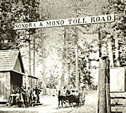 The portion of this route from Bridgeport to Route 108 (~ MNO 76.758 to MNO 94.461) was named
the "Sonora and Big Meadows Wagon Road" by Senate Bill 289 in 1901.
It was also named the "Sonora and Mono Wagon Road" by Resolution
Chapter 11 in 1901, and extended by Resolution Chapter 510 in 1919.
The portion of this route from Bridgeport to Route 108 (~ MNO 76.758 to MNO 94.461) was named
the "Sonora and Big Meadows Wagon Road" by Senate Bill 289 in 1901.
It was also named the "Sonora and Mono Wagon Road" by Resolution
Chapter 11 in 1901, and extended by Resolution Chapter 510 in 1919.
(Image source: Tuolumne County Historical Society)
 Named Structures
 There is a memorial marker at SBD 66.0 (San Bernardino County) in memory of CHP Officer
Larry J. Jaramillo. California Highway Patrol Officer Larry J.
Jaramillo died in the line of duty in a traffic collision on Route 395 at
the Kern County San Bernardino County line, while returning from court in
Inyo County on June 22, 1993. Officer Jaramillo joined the Department of
the California Highway Patrol in 1985, after successfully completing
training at the patrol academy where he received the outstanding athlete
award for his class, and, upon graduation, he reported to Morongo Basin,
as a state traffic safety officer in December 1985. In 1989, Officer
Jaramillo tested and qualified with the department to become a fixed wing
pilot and was assigned to the Inland Division Air Operations Unit
stationed in Daggett, California. On December 8, 1992, Officer Jaramillo
received the second highest award that the department may bestow, the
Special Act Award, for his rescue of two young men stranded in the
snow-covered mountains of Kern County during which Officer Jaramillo
continued his search for the young men despite warnings of adverse weather
conditions, endangering his life to continue the search until the men were
found. Memorial authorized by Assembly Concurrent Resolution 173,
Resolution Chapter 142, September 18, 2000.
There is a memorial marker at SBD 66.0 (San Bernardino County) in memory of CHP Officer
Larry J. Jaramillo. California Highway Patrol Officer Larry J.
Jaramillo died in the line of duty in a traffic collision on Route 395 at
the Kern County San Bernardino County line, while returning from court in
Inyo County on June 22, 1993. Officer Jaramillo joined the Department of
the California Highway Patrol in 1985, after successfully completing
training at the patrol academy where he received the outstanding athlete
award for his class, and, upon graduation, he reported to Morongo Basin,
as a state traffic safety officer in December 1985. In 1989, Officer
Jaramillo tested and qualified with the department to become a fixed wing
pilot and was assigned to the Inland Division Air Operations Unit
stationed in Daggett, California. On December 8, 1992, Officer Jaramillo
received the second highest award that the department may bestow, the
Special Act Award, for his rescue of two young men stranded in the
snow-covered mountains of Kern County during which Officer Jaramillo
continued his search for the young men despite warnings of adverse weather
conditions, endangering his life to continue the search until the men were
found. Memorial authorized by Assembly Concurrent Resolution 173,
Resolution Chapter 142, September 18, 2000.
(Image source: Calif. Assn of Highway Patrolmen)
This route also has the following Safety Roadside Rest Areas:
 National Trails
 The portion of this segment between Route 14 and US 6 was
part of the Midland Trail.
The portion of this segment between Route 14 and US 6 was
part of the Midland Trail.
 The routing of US 395 along the Eastern Sierra was also
known as El Camino Sierra
The routing of US 395 along the Eastern Sierra was also
known as El Camino Sierra
 US 395 was also known as the Three Flags Highway
as it served to connect Mexico, the United States, and Canada.
US 395 was also known as the Three Flags Highway
as it served to connect Mexico, the United States, and Canada.
Business Routes Scenic Route
[SHC 263.8] From Route 14 near Little Lake to Route 89 near Coleville.
Eligible for Scenic Highway status per [SHC 263]. The following portions have been officially designated as Scenic Highway and are signed:
 Freeway
[SHC 253.8] Entire portion.
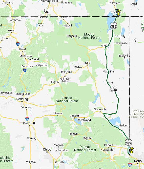 From the Nevada state line northwest of Reno to to the Oregon state line near
New Pine Creek via Alturas.
From the Nevada state line northwest of Reno to to the Oregon state line near
New Pine Creek via Alturas.
Post 1964 Signage HistoryThis segment remains as defined in 1963 as the original (c).
The portion of this route between Alturas and a point 6 mi W (i.e., between the two US 395/Route 299 junctions) is cosigned as US 395/Route 299, although it is legislatively US 395.
Pre 1964 Signage HistoryThe segment of US 395 from the Nevada state line northwest of Reno to Route 36 near Johnstonville (Susanville) was part of LRN 29, and was signed as US 395. It was a 1919 extension of the 1909 LRN 29, which ran as (signed) Route 36 between Red Bluff and Susanville (in 1933, LRN 29 was extended further to run, still as Route 36, between Route 3/Route 36 [LRN 35] to US 99 [LRN 3]).
It appears that the portion between the Nevada Border and Hallelujah Junction was also cosigned with Sign Route 24, and later as part of Alt US 40 (although a mid-1950s USGS map shows it cosigned with Route 70, which is odd as California Route 70 did not exist until 1964).
The segment from Alturas to the California-Oregon state line near New River was LRN 73, added in 1931. This was also signed as US 395. California Highways and Public Works, April 1931, noted that the justification for the addition what that it established a connection between the Oregon State Highway System and the Redding-Alturas lateral ([LRN 28]) of the California State Highway System. The project was considered a necessary link on an east of the Sierras routing. It was a designated Federal aid route. It had been recommended for inclusion in the State highway system by the Highway Advisory Board in 1925. At the time, Oregon was improving its roads from Klamath Falls, from Bend and from Burns territory (the Yellowstone cut-off) to the state line at New Pine Creek Oregon, with State and Federal funds, and had practically completed a surfaced road from the Columbia River and also from Klamath Falls to New Pine Creek. As of 1931, the unimproved condition of the California extension was withholding from the public the potential value of these routes. Within California the project will coordinate with the Redding-Alturas highway, and through the Alturas-Susanville route, with the Red Bluff - Susanville - Reno lateral [LRN 29]. There was also a contemplated connection from Lake Almanor to the Feather River road that would extend recreational traffic further south. The route qualified as an interstate connection, as the 1931 California Highway system lacked a connection to eastern Oregon.
The last segment addition occured in 1933, and was the segment between Susanville and Alturas (more formally, between LRN 29 (Route 36/US 395) and LRN 28 (Route 299)).
In 1954, Sign Route 24 was either co-signed or resigned as Alt US 40 (US 40A). The article announcing the designation indicated that existing signs
would be replaced by US 40 signs with the designation "Alt". The article
indicated that for the first 10 miles N, from US 40 in Solano County, the
new alternate route would be designated as US 99W and US 40A. A new
section of highway was being constructed to intersect with the existing US 99W at the Woodland Wye. This would be the segment that is now Route 113.
In Woodland, US40A joined with the existing US 99W / Sign Route 24 to Yuba
City; this is now Route 113. US 40A then followed Sign Route 24 (now Route 70) through Oroville and Quincy to US 395. Lastly, US 40A followed US 395
S to Reno, which was the eastern terminus of US 40A. The goal here was to
provide an alternate route across the Sierras when Donner Pass was closed.
(Source: Roseville Press-Tribune 3/23/1954 via Joel Windmiller
(email), 11/12/2023)
As US 395 was expanded, the typical approach seems to have been adding new NB lanes (often on a slightly separated roadway), and then converting the old highway to SB only.
Near Doyle, it appears the old routing used Constantia Road and Doyle Loop.
In Buntingville, Lakecrest Road is Old US 395. This extends into Janesville, where old US 395 was Main Street and Conrad Road.
In Johnstonville (Susanville), old US 395 used Johnstonville Road to Bangham Lane.
Between Standish and Litchfield, old US 395 used Union Road and Lambert Lane to Market Street. The corners were later softened.
Satellite maps show the old US 395 as an abandoned dirt path near Spanish Springs Peak (~ LAS 101.646 to LAS 102.673)
Near Alturas, US 395 was significantly rerouted. The original route used County Road 115 to E McDowell Ave, and then W along E McDowell to Main Street. US 395 then continued N along Main Street, Alturas.
StatusCurrently built to expressway standards for a stretch of 8 miles between the Nevada Border and Route 70.
At the end of May 2017, it was reported that Caltrans Dictrict 2 is
developing a 20-year plan to make improvements to US 395. This process
started by hosting workshops —four are planned—in cities along
the road—seeking citizens’ comments. Caltrans even went so far
as to bring homemade brownies (something that is above and beyond!). The
workshop in Alturas was attended by 15 local residents—including
elected and agency officials—was chockfull of happily-relayed
comments as the group studied the road, north from near Susanville to New
Pine Creek, at the California-Oregon border. In the workshop, three basic
questions were asked: What works well? What works not-so-well? How can it
be improved? Among improvements needed, according to the locals are:
(Source: aNewsCafe.com, 5/30/2017)
One little bit of information eeked out—from a participant and was
augmented by Caltrans staff: There is a longstanding plan to transform the
US 395 alignment from the Arizona-Mexico border to the Washington-Canada
border into a super highway akin to I-5. It even has a name: I–11.
“Not going to happen in our lifetime,” was the general
consensus from the group. Still, the idea of a full-bore interstate
knifing through Eastern California creates wild surmise, and the Caltrans
representative will include a notation about I–11 that “the
proposal is out there” in the new report being created.
(Source: aNewsCafe.com, 5/30/2017)
Sierra / Lassen Widening
In March 2016, the CTC authorized additional funding on US 395 in Sierra and Lassen Counties, from Nevada State line (apx 395 SIE R0.0L) to one mile north of Route 70 (395 LAS R5.215). Rehabilitate pavement. This project is located in a remote location and requires significant lab and materials support. A structures maintenance review identified bridgework that was not originally in the scope, which requires additional lab support and services. In addition, there is increased support needed for the superpaving methodology. This increase is consistent with the required work for a CAPM and adds $412,000 to the cost of the project.
In August 2016, the CTC approved $11,512,000 in funding for US 395 in Sierra (PM R0.0/R3.1) and Lassen (PM R0.0/5.6) Counties, from Nevada State line to 1 mile north of Route 70; also, on Route 70 from PM 3.5 to 3.9. Outcome/Output: Rehabilitate 34.2 lane miles of pavement to extend pavement service life and improve ride quality. Project will overlay pavement, upgrade nine culverts, install approach slabs at eight locations, rehabilitate four bridges with polyester concrete overlay, install one intelligent transportation system (ITS) monitoring device, and make ADA and drainage improvements at the Agriculture Inspection Station.
Hallulujah Junction Improvements (02-Las-395 7.5/R19.0)
In March 2025, the CTC amended the following project
into the 2024 SHOPP: 02-Las-395 7.5/R19.0. PPNO 02-3931; ProjID
0223000178; EA 0K550. US 395 Near Hallelujah Junction, from 2.9 miles
north of Route 70 to 1.6 miles north of Constantia Road. Construct 12-foot
paved median with concrete barrier and 8-foot paved shoulders, improve
clear recovery zone, extend culverts, widen two bridges, install
guardrail, and construct truck turn-outs. Concurrent COS allocation under
Resolution FP-24-67; March 2025. Allocation ($ × $1000) PA&ED
$3,270 ; PS&E $3,280; R/W Sup $270; ⊘Con
Sup $7,610; ⊘R/W Cap $1,735; ⊘Const Cap $58,680; TOTAL $74,845.
BC: 9/4/2029
(Source: March 2025 CTC Agenda, Agenda Item 2.1a.(1a) #1)
In March 2025, the CTC approved the following SHOPP
Pre-Construction Phase allocation: $3,270,000. 02-Las-395 7.5/R19.0. PPNO
02-3931; ProjID 0223000178; EA 0K550. US 395 near Hallelujah Junction,
from 2.9 miles north of Route 70 to 1.6 miles north of Constantia Road.
Construct 12-foot paved median with concrete barrier and 8-foot paved
shoulders, improve clear recovery zone, extend culverts, widen two
bridges, install guardrail, and construct truck turn-outs. Concurrent
Amendment under SHOPP Amendment 24H-009; March 2025. Programmed (Allocation,
if different): PA&ED $3,270,000.
(Source: March 2025 CTC Agenda, Agenda Item 2.5b.(2a) #2)
Doyle Improvements (02-Las-395 R19.0/25.6)
In June 2026, the CTC amended the following project
into the 2026 SHOPP: 02-Las-395 R19.0/25.6. PPNO 02-3970; ProjID
0226000020; EA 3K150. US 395 Near Doyle, from 4.0 miles south to 2.6 miles
north of Doyle Overhead. Construct paved median with concrete
barrier, provide buffer zones, place rumble strips, improve clear recovery
zones, and construct truck turnouts. Concurrent COS allocation under
Resolution FP-25-106; June 2026. Allocation ($ × $1000): PA&ED
$3,680; PS&E $2,200; R/W Sup $330; Con Sup $5,450; R/W Cap $4,877;
Const Cap $27,540; TOTAL $44,097. BC: 10/23/2029.
(Source: June 2026 CTC Agenda, Agenda Item 2.1a.(1a) #3)
In October 2017, the CTC authorized vacation of right of way in the county of Lassen along Route 395, between Janesville Grade and Lake Crest Road (02-Las-395-PM 52.3/52.6), consisting of stock trail easements no longer needed for State highway purposes.
In March 2013, the CTC provided advance authorization for $2,995,000 to rehabilitate 12.0 lane miles of roadway to improve the ride quality, prevent further deterioration of the road surface, minimize the costly roadway repairs and extend the pavement service life on the segment in and near Johnstonville, from 0.1 mile north of Sunnyside Road (apx 395 LAS 56.437) to 0.3 mile south of Route 36 (apx 395 LAS R60.693).
In May 2008, the CTC considered relinquishment of right of way in the city of Alturas, at Court Street (apx 395 MOD 22.884), East Street, East A Street, and East B Street, consisting of reconstructed and relocated city streets.
Naming The portion of US 395
from the South Fork Pit River Bridge to a portion of the Modoc National
Wildlife Refuge (~ MOD 16.523 to MOD 20.000) in the County of Modoc is
named the "Deputy Sheriff Jack Hopkins Memorial Highway". It was
named in memory of Deputy Sheriff Jack Hopkins, who was born in Livermore,
California, in August 1985, and was named after his grandfather, Jack L.
Hopkins, who was the first mayor of Rolling Hills Estates, California.
Hopkins was raised on a cattle ranch in the rural Shasta Valley and
baptized in the Shasta River. Jack Hopkins attended Grenada and Big
Springs Elementary schools and graduated from Yreka High School in 2004.
Hopkins, who learned a great deal of discipline and respect from Mitch
Klier, of Klier’s Martial Arts, earned a black belt in karate and
won a world championship karate title in 2001. Hopkins went on to pursue
multiple associate of arts degrees at Butte College, then returned to
Butte College to attend the police academy with his older brother, Officer
Sam Hopkins, and graduated in 2013. Hopkins was known for being the type
of person whose handshake was his “word,” a happy,
good-natured guy with a great personality, and a big smile who laughed
often. Jack Hopkins began his law enforcement career with the Alturas
Police Department and transferred to the Modoc County Sheriff’s
Office. Jack Hopkins was killed in the line of duty on October 19, 2016.
Named by Assembly Concurrent Resolution (ACR) 29, 8/30/2017, Res. Chapter
130, Statutes of 2017.
The portion of US 395
from the South Fork Pit River Bridge to a portion of the Modoc National
Wildlife Refuge (~ MOD 16.523 to MOD 20.000) in the County of Modoc is
named the "Deputy Sheriff Jack Hopkins Memorial Highway". It was
named in memory of Deputy Sheriff Jack Hopkins, who was born in Livermore,
California, in August 1985, and was named after his grandfather, Jack L.
Hopkins, who was the first mayor of Rolling Hills Estates, California.
Hopkins was raised on a cattle ranch in the rural Shasta Valley and
baptized in the Shasta River. Jack Hopkins attended Grenada and Big
Springs Elementary schools and graduated from Yreka High School in 2004.
Hopkins, who learned a great deal of discipline and respect from Mitch
Klier, of Klier’s Martial Arts, earned a black belt in karate and
won a world championship karate title in 2001. Hopkins went on to pursue
multiple associate of arts degrees at Butte College, then returned to
Butte College to attend the police academy with his older brother, Officer
Sam Hopkins, and graduated in 2013. Hopkins was known for being the type
of person whose handshake was his “word,” a happy,
good-natured guy with a great personality, and a big smile who laughed
often. Jack Hopkins began his law enforcement career with the Alturas
Police Department and transferred to the Modoc County Sheriff’s
Office. Jack Hopkins was killed in the line of duty on October 19, 2016.
Named by Assembly Concurrent Resolution (ACR) 29, 8/30/2017, Res. Chapter
130, Statutes of 2017.
(Image source: KOBI-5; Girdner Funeral Chapel)
Named StructuresThis route also has the following Safety Roadside Rest Areas:
I normally don't note SRRA projects, but this one is interesting as
the SRRA is being relocated. In January 2024, Caltrans released the
draft 2024 SHOPP, which contained the following project: 02-Lassen-395
103.6 /103.9. PPNO 02-3734; ProjID 0219000016; EA 4H740. US 395 Near
Ravendale, from 4.8 miles south to 4.5 miles south of School House
Road; also at Secret Valley Safety Roadside Rest Area (SRRA) (PM
96.5); also at various locations on Route 395 in Lassen and Modoc
Counties. Remove existing Secret Valley SRRA and construct at a new
location, and upgrade rest area signs at various locations.. Proposed
($ × 1000): PA&ED: $1,200; PS&E: $1,500; R/W $84; R/W Sup
$170; Con $10,700; Con Sup: $1,700; Total: $15,354. Begin Con:
5/30/2028.
(Source: 2024 Draft SHOPP v4.0, 1/31/2024)
In June 2024, the CTC authorized the following pre-construction-phase
2024 SHOPP allocation: #1. $1,200,000. 02-Lassen-395 103.6 /103.9.
PPNO 02-3734; ProjID 0219000016; EA 4H740. US 395 Near Ravendale, from
4.8 miles south to 4.5 miles south of School House Road; also at
Secret Valley Safety Roadside Rest Area (SRRA) (PM 96.5); also at
various locations on Route 395 in Lassen and Modoc Counties. Remove
existing Secret Valley SRRA and construct at a new location, and
upgrade rest area signs at various locations.. Allocation (Programmed,
if different): PA&ED $1,200,000
(Source: June 2024 CTC Agenda, Agenda Item 2.5b.(3) #1)
Freeway[SHC 253.8] From the Nevada state line northwest of Reno to Route 36 near Johnstonville and from Route 36 near Termo to the Oregon state line.
 Historical Route
As of March 2008, the California Transportation Committee unanimously approved the designation of former US 395 as a historic route from San Diego to the Oregon border. It is still pending approval by the legislature and the governor. However, anticipating approval, San Diego County Supervisor Bill Horn approved $4,000 for the 31 signs that now mark old 395 in his district -- from Vista to the Bonsall Bridge, through downtown Fallbrook, to Rainbow.
On July 8, 2008, Resolution Chapter 79 officially designated specified sections of former US Highway Route 395 as Historic US Highway 395. The resolution noted that former US 395 was a scenic stretch of highway that ran through historic areas of the County of Riverside and provided the only direct route from San Diego to the Lake Tahoe region and northern Nevada, before heading back into California on its way north to Oregon and all the way into Canada. While former US 395 remains largely intact through the Counties of Inyo, Mono, Sierra, Lassen, and Modoc, only sections of former US 395 still exist in portions of the County of San Diego and the high desert area of the County of San Bernardino; most of the former highway route has been replaced by I-15 and I-215 in the Counties of San Diego, Riverside, and San Bernardino. US 395, which remains as I-15 and I-215, was the major and most significant connection between San Diego, the Inland Empire, and the eastern Sierra Nevada region. US 395 was known as the Cabrillo Parkway (and later the Cabrillo Freeway) in San Diego, now Route 163, it was the first freeway to be constructed in San Diego and opened to traffic in 1948. Part of the original routing of former US 395 in northern San Diego County includes the old Bonsall Bridge, one of the earliest automotive crossings over the San Luis Rey River, later becoming part of Route 76. The portion of former US 395 between Temecula and Lake Elsinore was part of the Butterfield Overland Mail route, the first major overland delivery service to southern California, established September 16, 1858. After its realignment eastward, former US 395 became the first major expressway and freeway system in the southern portion of the County of Riverside in the early 1950s, servicing the Cities of Temecula, Murrieta, Menifee, Sun City, and Perris. Today this is I-215. The portion of former US 395 between the Cities of San Bernardino and Hesperia, near modern US 395, traverses the Cajon Pass with old US 66 and old US 91, most famously used by the Mormons in 1851 in their crossing into the valley where they subsequently founded the modern Cities of San Bernardino and Riverside. The heritage in the regions through which former US 395 passed was greatly diminished when the former highway was replaced by suburban streets and I-15 and I-215.The Legislature hereby recognizes the remaining segments of US 395 for their historical significance and importance in the development of California, and designates those segments as Historic State Highway Route 395. Named by Assembly Concurrent Resolution (ACR) 98, Resolution Chapter 79, on 7/3/2008.
In January 2016, it was noted that more cities were signing historic US 395. Moreno Valley will be the latest Inland city, joining others from
Riverside to Temecula, to rediscover the US 395 and put up brown signs
along the route of the once-vital artery. The city and Moreno Valley
Historical Society dedicated the 2-mile section of the 395 between
Eucalyptus and Cactus avenues on Memorial Day with a weekend of
activities. Though US 66, another U.S. highway, is considered the mother
road connecting the nation east to west, the 395 is its lesser-known
north-south counterpart. The 1,400-mile road was known as the Three Flag
Highway because it went from the Mexican border through several Western
states to the Canadian border, said Jeffery Harmon, founder of the
Historic Route 395 Association. It was officially designated U.S. Highway
395 in 1939 after passage of federal legislation. However, it had existed
as a series of dirt roads from San Diego to the Cajon Pass for decades.
During World War II, at the urging of the military, the highway was
improved to provide a better link between San Diego’s Navy base, a
weapons depot in Fallbrook and March Field in what later became Moreno
Valley. The route was nicknamed the Cannonball Highway because of its
military importance. The highway faded into obscurity after years of
rerouting and the development of other north-south routes, I-15 and I-15E
(now I-215), in the 1970s. By the 1980s, US 395 had been decommissioned in
Riverside and San Diego counties, though it continues to run from Hesperia
in San Bernardino County along the eastern Sierra Nevada and north to
Canada. In recent years, several cities have begun efforts to commemorate
US 395. In San Diego and other cities in San Diego County, signs were put
up along the route. Communities such as Fallbrook, Rainbow, Temecula,
Murrieta, Lake Elsinore, Perris and Riverside did the same. In Riverside,
city officials put up 36 signs on downtown streets, including Market
Street and University Avenue, which still has roadside hotels that are a
remnant of when it was part of the highway, said Steve Lech, president of
the Riverside Historical Society.
(Source: Press-Enterprise, via AAroads)
ACR 26 requested the Department of Transportation, upon application by an interested local agency or private entity, to identify any section of former U.S. Highway Route 6 that is still a publicly maintained highway and that is of interest to the applicant, and to designate that section as Historic U.S. Highway Route 6. Chaptered July 3, 2007. Resolution Chapter 67.
National Trails All of original US 395 (i.e., current Route 395 plus parts
of I-15, I-215, and Route 163) was part of the "Three Flags Highway".
 Exit Information
 Other WWW Links
 Blue Star Memorial Highway
This route (post-1964 US 395) was designated as a "Blue Star Memorial Highway" by Assembly Concurrent Resolution 112, Ch. 143 in 1984.
 Statistics
Overall statistics for US 395:
© 1996-2024 Daniel P. Faigin.
Maintained by: Daniel P. Faigin
<webmaster@cahighways.org>.
 Route 380
 Route 399