
 California Highways:
Click here for a key to the symbols used. An explanation of acronyms may be found at the bottom of the page.
 Routing
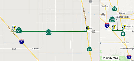 From Route 5 to Route 99 south of Greenfield.
 Post 1964 Signage History
This segment remains as defined in 1963.
 Pre 1964 Signage History
This segment was LRN 264, defined in 1959.
 Naming
"Bear Mountain" Boulevard
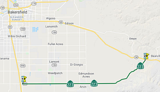 From Route 99 south of Greenfield to Route 58.
Post 1964 Signage HistoryThis segment remains as defined in 1963.
Pre 1964 Signage HistoryThis was part of LRN 140, defined in 1933. It does not appear to have been signed before the 1964 renumbering.
 Status
Route 184 Roundabout (06-Kern-223 PM R16.0)
The 2020 SHOPP, approved in May 2020, included the
following new Mobility item of interest: 06-Kern-223 PM R16.0 PPNO 6758
Proj ID 0614000057 EA 0R190. Route 223 near Weedpatch, at Route 184
(Wheeler Ridge Road) intersection. Construct roundabout. (Additional
$1,500,000 from local contribution). Programmed in FY22-23, with
construction scheduled to start in January 2023. Total project cost is
$3,700K, with $2,700K being capital (const and right of way) and $1,000K
being support (engineering, environmental, etc.),
(Source: 2020 Approved SHOPP a/o May 2020)
In June 2021, the CTC amended the SHOPP as follows:
06-Ker-223 R16.0 PPNO 6758 ProjID 0614000057 EA 06-0R190. Route 223 Near
Weedpatch, at Route 184 (Wheeler Ridge Road) intersection. Construct
roundabout. (Additional $1,500,000 from local contribution). Note:
Increase construction capital from $2,700K to $4,400K due to a deeper
roadway pavement section required to address current pavement failure.
This change results in additional asphalt, traffic control, and aggregate
base. Accelerate delivery year to FY21-22 to align with the available
local funding contribution.
(Source: June 2021 CTC Agenda, Agenda Item
2.1a.(1d) #41)
In October 2021, the CTC approved the following
allocation for construct/construction support phases: $6,167,000.
06-Ker-223 R15.7/R16.0. PPNO 06-6758; ProjID 0614000057; EA 0R190. Route 223 Near Weedpatch, from 0.3 miles west to 0.3 miles east of Route 184
(Wheeler Ridge Road); also on Route 184 from 0.3 miles south to 0.3 miles
north of Route 223 (Bear Mountain Boulevard). (Additional $1,500,000 from
local contribution.) Outcome/Output: Construct roundabout to
improve operations and safety. Allocation: CON ENG $1,000,000; CONST
$4,400,000. (CEQA - CE, 1/6/2015; Re-validation 12/16/2020) (NEPA - CE,
1/6/2015; Re-validation 12/16/2020) (SHOPP Minor expenditures of $635,091
for PA&ED, $2,491,697 for PS&E, and $790,068 for R/W Sup.)
(Source: October 2021 CTC Agenda, Agenda Item
2.5b.(1) #9)
Naming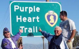 The portion of Route 223 from
Route 99 to Route 58, in the County of Kern is included in the National
Purple Heart Trail. The National Purple Heart Trail was established in
1992 for the purpose of commemorating and honoring men and women who have
been wounded or killed in combat while serving in the United States Armed
Forces. The National Purple Heart Trail courses its way across the vast
majority of the United States. In 2001, pursuant to Senate Concurrent
Resolution 14, the Legislature designated portions of I-5 and I-80 as
California's selections for inclusion in the National Purple Heart Trail.
In 2009, pursuant to Assembly Concurrent Resolution 12, the Legislature
designated a portion of US 101 for inclusion in the National Purple Heart
Trail. Thie resolution designates an additional portion of the state
highway system for inclusion in the National Purple Heart Trail in order
to honor the men and women who have been wounded or killed in combat while
serving in the United States Armed Forces. Named by Senate Concurrent
Resolution (SCR) 105, Resolution Chapter 95, on 8/20/2010.
The portion of Route 223 from
Route 99 to Route 58, in the County of Kern is included in the National
Purple Heart Trail. The National Purple Heart Trail was established in
1992 for the purpose of commemorating and honoring men and women who have
been wounded or killed in combat while serving in the United States Armed
Forces. The National Purple Heart Trail courses its way across the vast
majority of the United States. In 2001, pursuant to Senate Concurrent
Resolution 14, the Legislature designated portions of I-5 and I-80 as
California's selections for inclusion in the National Purple Heart Trail.
In 2009, pursuant to Assembly Concurrent Resolution 12, the Legislature
designated a portion of US 101 for inclusion in the National Purple Heart
Trail. Thie resolution designates an additional portion of the state
highway system for inclusion in the National Purple Heart Trail in order
to honor the men and women who have been wounded or killed in combat while
serving in the United States Armed Forces. Named by Senate Concurrent
Resolution (SCR) 105, Resolution Chapter 95, on 8/20/2010.
(Image source: Bakersfield Californian)
 Freeway
[SHC 253.1] Entire route. Added to the Freeway and Expressway system in 1959.
 Other WWW Links
 Statistics
Overall statistics for Route 223:
 Pre-1964 Legislative Route
In 1947 (1st Ex Sess), Chapter 11 defined LRN 223 as “a point on [LRN 2] near Division Street to [LRN 56]”.
This was the routing from US 101 near Division Street to Route 1 in San Francisco. It appears to have been a routing along Oak and Fell Streets in San Francisco, and then through the Golden Gate Park to Route 1. This was originally the Panhandle and Central Freeways. Later, it was the Central and Western Freeway I-80 routing. In the 1955 trafficways plan, it was shown as "Deleted, pending further study".
 The legislative definitions that would become the Panhandle Freeway and the
Central Freeway were added to the State Highway System via LRN 223 in
1947, when LRN 223 was defined as "a point on LRN 2 [US 101] near Division
Street to LRN 56 [Route 1]." The Panhandle Freeway as originally conceived
began at the Central Freeway. The corridor was located through
Panhandle Park between Haight Street and McAllister Street. Upon
reaching Golden Gate Park the Panhandle Freeway terminated and split into
couplets: the Richmond Freeway and the Sunset Freeway. The Panhandle was
part of the connection with the Central and Bayshore Freeways. In 1953,
the first Central Freeway segment was authorized; it was 0.9 miles long
extending from 13th/Mission Street to vicinity of Turk
Street. Mission Street was where the Central Freeway would meet the
Bayshore Freeway (US 101, LRN 2, although part of the Central Freeway was
LRN 2). The Panhandle Freeway would be a 2.3-mile limited access corridor
that would connect LRN 2 at the Central Freeway to LRN 56 (Route 1).
The purpose of the Panhandle Freeway was to act as a bypass for traffic to
more easily access the Golden Gate Bridge in addition to serving the
neighborhoods of Richmond and Sunset.
The legislative definitions that would become the Panhandle Freeway and the
Central Freeway were added to the State Highway System via LRN 223 in
1947, when LRN 223 was defined as "a point on LRN 2 [US 101] near Division
Street to LRN 56 [Route 1]." The Panhandle Freeway as originally conceived
began at the Central Freeway. The corridor was located through
Panhandle Park between Haight Street and McAllister Street. Upon
reaching Golden Gate Park the Panhandle Freeway terminated and split into
couplets: the Richmond Freeway and the Sunset Freeway. The Panhandle was
part of the connection with the Central and Bayshore Freeways. In 1953,
the first Central Freeway segment was authorized; it was 0.9 miles long
extending from 13th/Mission Street to vicinity of Turk
Street. Mission Street was where the Central Freeway would meet the
Bayshore Freeway (US 101, LRN 2, although part of the Central Freeway was
LRN 2). The Panhandle Freeway would be a 2.3-mile limited access corridor
that would connect LRN 2 at the Central Freeway to LRN 56 (Route 1).
The purpose of the Panhandle Freeway was to act as a bypass for traffic to
more easily access the Golden Gate Bridge in addition to serving the
neighborhoods of Richmond and Sunset.
(Source: Gribblenation Blog (Tom Fearer), "The planned Panhandle Freeway of San Francisco (Interstate 80)", July 2024)
By 1954, the Bayshore Freeway had been completed to Bryant Street in San
Francisco. Mainline US 101 was relocated from Potrero Avenue onto
the new freeway segment to Bryant Street. US 101 was carried to 10th
Street via the Bryant Street ramp. Part of LRN 223 ran from the
constructed part of the Bayshore Freeway west to Mission Street. The
Panhandle Freeway west to LRN 56 followed Lincoln Way. During 1955, the
Panhandle Freeway corridor adoption was deleted from the San Francisco
trafficways plan. The Panhandle Freeway was rebranded as the
"Western Freeway" in 1956. Planners proposed an elevated iteration
of the Western Freeway during said year which would branch from LRN 56 at
19th Avenue. The elevated proposal was ultimately
rejected by the San Francisco Board of Supervisors in an 8-3 vote. The
Division of Highways proposed a depressed iteration of the Western Freeway
in 1960. The corridor was again rejected by the San Francisco Board
of Supervisors in a 6-5 vote in 1962. By 1964, this had morphed into the
Panhandle Parkway proposal. That proposal was presented by the San
Francisco Board of Supervisors and was rejected during October 1964 by a
6-5 vote. The Board of Supervisors fully objected to the prospect of
constructing the corridor through the proposed Crosstown Tunnel.
Following the rejection the California Highway Commission decided against
adopting an alignment. The San Francisco Board of Supervisors voted
against the Panhandle Parkway 6-5 for a final time on March 21,
1966. 1968 Legislative Chapter 282 transferred the planned Panhandle
Parkway from I-80 to the second iteration of Route 241. Route 241 was
deleted in 1972.
(Source: Gribblenation Blog (Tom Fearer), "The planned Panhandle Freeway of San Francisco (Interstate 80)", July 2024)
Between 1968 and 1972, this route was Route 241 (note that LRN 222 was the 1964-1965 Route 241).
© 1996-2024 Daniel P. Faigin.
Maintained by: Daniel P. Faigin
<webmaster@cahighways.org>.
 Route 222
 Route 224