
 California Highways:
Click here for a key to the symbols used. An explanation of acronyms may be found at the bottom of the page.
 Routing
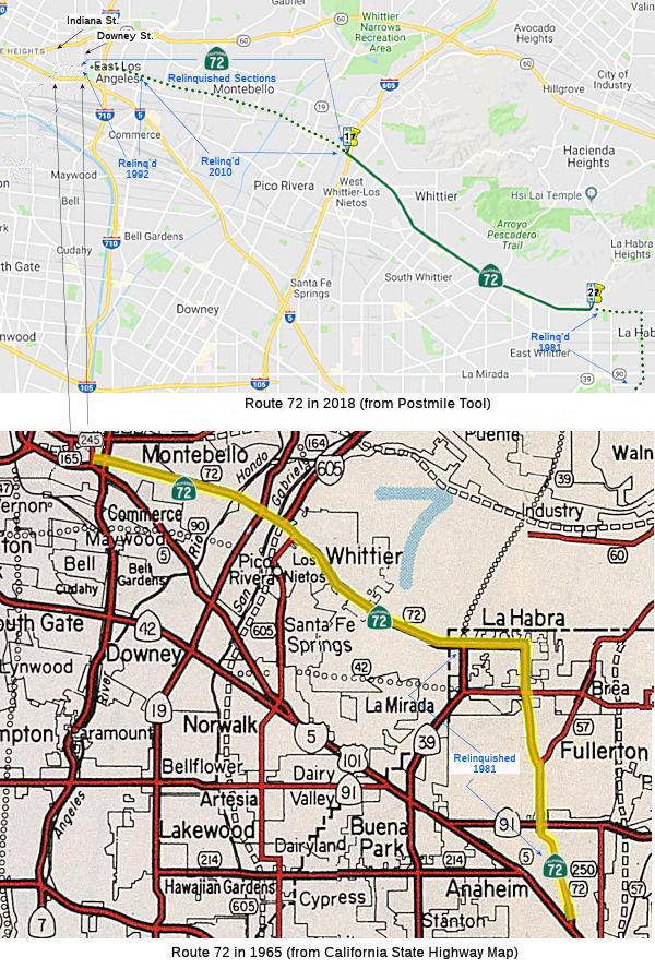 From Route 39
to Route 605 in Whittier.
From Route 39
to Route 605 in Whittier.
(a) This will cease to be a state highway when the Route 90 freeway is completed from Route 5 to Route 39.
(b) The relinquished former portions of Route 72 within the City of Montebello, the City of Pico Rivera, and the County of Los Angeles are not state highways and are not eligible for adoption under Section 81. For the relinquished former portions of Route 72, the Cities of Montebello and Pico Rivera and the County of Los Angeles shall maintain within their respective jurisdictions signs directing motorists to the continuation of Route 72.
The Montebello Relinquishment was considered by the CTC in September 2000.
The portion of Route 72 in Pico Rivera was up for relinquishment in July 2005.
In 2019, AB 1810 authorized relinquishment in the City of Whittier and the County of Los Angeles. Note that this will only leave the portion of the route in the City of La Habra, between Route 39 and Valley Home Avenue.
In June 2022, the CTC amended the following capital
project into the SHOPP: 7-LA-72 0.0/6.767. PPNO 07-5965; ProjID
0722000199; EA 38700. Route 72 In Whittier, from the Orange County line to
Route 605. Financial Contribution Only (FCO) to the City of Whittier
to relinquish roadway. Allocation ($ × 1,000): PA&ED $10; Const
Cap $10,450; TOTAL $10,460. This will essentially completes the
relinquishment of Route 72 in Los Angeles County once completely funded
and the relinquishment recorded. This will leave only the portion from
Route 39 (ORA 0) to Valley Home Avenue (ORA 11.914). Next is the
allocation of the funds. Note that the actual relinquishment was not on
the June agenda, so that is still pending.
(Source: June 2022 CTC Agenda, Agenda Item
2.1a.(1a) #12)
In January 2024, Caltrans released the draft 2024
SHOPP, which contained the following project: 07-Los Angeles-72 0.0
/6.767. PPNO 07-5965; ProjID 0722000199; EA 38700. Route 72 In Whittier,
from Valley Home Avenue to Esperanza Avenue. Financial Contribution
Only (FCO) to the City of Whittier to relinquish roadway. Proposed ($
× 1000): PA&ED: $0; PS&E: $0; R/W $0; R/W Sup $0; Con
$16,700; Con Sup: $0; Total: $16,700.
(Source: 2024 Draft SHOPP v4.0, 1/31/2024)
 Post 1964 Signage History
In 1963, this route was defined as the route from Route 5 in or near Anaheim to Route 245. Route 245 was Downey Road.
In 1963, Chapter 1372 changed the terminus of the route to be "Downey Road near the City of Los Angeles." This was just a rewording reflecting the 1965 deletion of Route 245, which was a temporary state highway during construction of Route 5 running from Route 5 near Los Angeles to Route 60 at the intersection of Downey Road. The 1965 act also added some relinquishment conditions:
So clearly the intent was for Route 72 to be a temporary route while the freeway system was being built out.
In 1981, Chapter 292 truncated the route to be "Route 39 to Downey Road near the City of Los Angeles." This eliminated the portion between Route 5 and Route 39, reflecting the completion of the Route 57 freeway. The second condition ("Route 72 shall cease to be a state highway when Route 90 freeway is completed from Route 5 to Route 39.") remained. As for the former portions of Route 72: the portion from Route 5 to Harbor Blvd [Route 39] was relinquished from the state highway system, and the portion from Harbor Blvd [Route 39] to Route 39 was transferred to Route 39.
In 1985, Chapter 385 added additional conditions to the route definition: “…except as follows: (a) Route 72 shall cease to be a state highway when Route 90 freeway is completed from Route 5 to Route 39. (b) Notwithstanding subdivision (a), that portion of Route 72 from Atlantic Boulevard to Downey Road shall cease to be a state highway when the County of Los Angeles completes the reconstruction of Whittier Boulevard approximately between these two limits.”
In 1988, Chapter 106 added an additional condition: “(c) Notwithstanding subdivision (a), the portion of Route 72 from Route 605 to Atlantic Boulevard shall cease to be a state highway when the County of Los Angeles, the City of Montebello, and the City of Pico Rivera complete the reconstruction of their respective portions of Whittier Boulevard approximately between these two limits.”
In 1992, Chapter 1243 changed the route to "Route 39 to Atlantic Boulevard near the City of Los Angeles". This reflected the completion of subsection (b), eliminated Atlantic to Downey Road.
At one time, there was a permit that allowed the closure of this route to all vehicular traffic, except emergency traffic, between Eastern and Atlantic Blvd on Friday, Saturday, and Sundy nights between 9:30 pm and 5:00 am. This permit was granted to reduce the "cruising" that was occuring on the route on those evenings. This segment is no longer part of the routing.
In 2010, Chapter 421 (SB 1318, 9/29/10) changed the terminus of the
definition: "to Atlantic Boulevard near the City of Los Angeles
to Route 605 in Whittier". Appropriate adjustments were made in
subsection (b) as well. It used to read: "(b) Notwithstanding subdivision
(a), any portion of Route 72 from Route 605 to Atlantic Boulevard ceases
to be a state highway when the County of Los Angeles, the City of
Montebello, and the City of Pico Rivera complete the reconstruction of
their respective portions of Whittier Boulevard approximately between
these two limits."
In 2019, AB 1810 (Chapter 636, 10/8/2019) authorized relinquishment in the city of Whitter and the County of Los Angeles by adding the following to the Streets and Highways Code:
(c) The commission may relinquish to the City of Whittier and the County of Los Angeles the portion of Route 72 within their respective jurisdictional limits, upon terms and conditions the commission finds to be in the best interests of the state, if the department and the city and the county enter into an agreement providing for that relinquishment.
(1) A relinquishment under this subdivision shall become effective on the date following the county recorder’s recordation of the relinquishment resolution containing the commission’s approval of the terms and conditions of the relinquishment.
(2) On and after the effective date of the relinquishment, all of the following shall occur:
(A) Any portion of Route 72 relinquished pursuant to this subdivision shall cease to be a state highway.
(B) Any portion of Route 72 relinquished pursuant to this subdivision shall be ineligible for future adoption under Section 81.
(C) For any portion of Route 72 relinquished pursuant to this subdivision, the City of Whittier and the County of Los Angeles shall maintain signs within their respective jurisdictional limits directing motorists to the continuation of Route 72.
If the portion authorized for relinquishment in 2019 is relinquished, the only remaining adopted portion of Route 72 would be between Route 39 and Valley Home Avenue.
In June 2022, the CTC amended the following capital project into the
SHOPP: 7-LA-72 0.0/6.767. PPNO 07-5965; ProjID 0722000199; EA 38700. Route 72 In Whittier, from the Orange County line to Route 605. Financial
Contribution Only (FCO) to the City of Whittier to relinquish roadway.
Allocation ($ × 1,000): PA&ED $10; Const Cap $10,450; TOTAL
$10,460. This essentially completes the relinquishment of Route 72 in Los
Angeles County. This will leave only the portion from Route 39 (ORA 0) to
Valley Home Avenue (ORA 11.914). Next is the allocation of the funds. Note
that the actual relinquishment was not on the June agenda, so that is
still pending. Related to this, the CTC also made the following SHOPP
amendment: 07-LA-72 0.0/6.8. PPNO 07-5158; ProjID 0716000299; EA 33310.
Route 72 In Whittier, from Valley Home Avenue to Esperanza Avenue. Construct
and upgrade curb ramps, sidewalks, driveways, pedestrian pathways, Class
III bikeway lanes, Accessible Pedestrian Signals (APS) and push buttons
to meet current Americans with Disabilities Act (ADA) standards. Financial
Contribution Only (FCO) to City of Whittier to relinquish roadway.
Note: This project is being changed to a relinquishment project and will
be combined at construction allocation ($6,250K) with EA 38700/PPNO
07-5965. Amendments ($ × 1,000): Con Sup $2,400 ⇒ $0; R/W Cap
$692 ⇒ $0; TOTAL $18,842 ⇒ $15,750.
In January 2024, Caltrans released the draft 2024 SHOPP, which contained
the following project: 07-Los Angeles-72 0.0 /6.767. PPNO 07-5965;
ProjID 0722000199; EA 38700. Route 72 In Whittier, from Valley Home Avenue
to Esperanza Avenue. Financial Contribution Only (FCO) to the City
of Whittier to relinquish roadway. Proposed ($ × 1000): PA&ED:
$0; PS&E: $0; R/W $0; R/W Sup $0; Con $16,700; Con Sup: $0; Total:
$16,700.
(Source: 2024 Draft SHOPP v4.0, 1/31/2024)
(Source: June 2022 CTC Agenda, Agenda Item 2.1a.(1a) #12 & #55)
The route currently is along Whittier Blvd.
 Pre 1964 Signage History
 The current routing was originally signed as US 101, and dates back
to the definition of US 101 in the 1930s. It was LRN 2, defined in 1909.
The current routing was originally signed as US 101, and dates back
to the definition of US 101 in the 1930s. It was LRN 2, defined in 1909.
By 1915, LRN 2 had been completed from the Los Angeles/Orange County line
to Anaheim to State standards. A 1917 map shows LRN 2 following Whittier
Boulevard, Spadra Road and Los Angeles Street from the Los Angeles city
limit to Anaheim, passing through the communities of Montebello, Whittier,
La Habra and Fullerton. The route along Whittier Blvd was widened in
1924. In 1925, a new bridge was constructed over the San Gabriel River,
opening in 1926. In 1925, LRN 2/Whittier Boulevard was expanded from
Montebello to Workman Mills Road in Whittier. In 1926, the Rio Hondo
Bridge along LRN 2/Whittier Boulevard was moved 15 feet upstream to a new
alignment, allowing the structure to be twinned. In 1927, the expansion of
US 101/LRN 2/Whittier Boulevard from Michigan Avenue to the Orange County
line was completed. By 1935, the routing of US 101 was approaching Whitter
Boulevard via Boyle Avenue in Los Angeles. From Los Angeles, US 101/LRN 2 followed Whittier Boulevard to La Habra in Orange County via
Montebello and Whittier. US 101/LRN 2 departed La Habra via Spadra
Road towards Anaheim via Fullerton, passing through Anaheim via Los
Angeles Street south towards Santa Ana.
(Source: Gribblenation Blog (Tom Fearer), "California State Route 72 (former US Route 101 between Los Angeles and Anaheim)", 6/10/2023)
By 1942, work on US 101 Bypass had begun with the transformation of Sign
Route 26.. The 1942 Division of Highways Map shows Sign Route 26 with a
gap originating at the eastern terminus of LRN 173 at Indiana Street in
Los Angeles. Much of what had been Sign Route 26 on
Anaheim-Telegraph Road (LRN 166) was designated as US 101 Bypass.
From Anaheim-Telegraph Road, US 101 Bypass followed Lakewood Boulevard
(LRN 168), Firestone Boulevard (LRN 174) and Manchester Boulevard (LRN 174) to Anaheim. Mainline US 101 followed Whittier Boulevard, Spadra
Road and Los Angeles Street between Los Angeles-Anaheim. By the end of
1952, US 101 Bypass would be completed between Rosemead Boulevard and the
Los Angeles Civic Center, with motorists using Lakewood Boulevard and
Firestone Boulevard east of Rosemead Boulevard to Norwalk. By 1953, the
Bypass was complete to Slauson, and by 1954, to Pioneer Blvd near Norwalk.
At this time, mainline US 101 was realigned onto the Santa Ana Freeway
(LRN 166), an interim routing on Pioneer Boulevard and Firestone
Boulevard/Manchester Boulevard (LRN 174) between Los Angeles to
Anaheim. The former mainline of US 101 on LRN 2 was no longer signed
as US 101. In the 1964 renumbering, former US 101 on LRN 2 was renumbered
as Route 72 between I-5 and new Route 245 (Downey Road).
(Source: Gribblenation Blog (Tom Fearer), "California State Route 72 (former US Route 101 between Los Angeles and Anaheim)", 6/10/2023)
Sign Route 72 was not defined as part of the initial state signage of routes in 1934. It does not appear that any route was signed as Route 72 between 1934 and 1964.
 Status
The SAFETEA-LU act, enacted in August 2005 as the reauthorization of TEA-21, provided the following expenditures on or near this route:
In June 2022, the CTC amended the following capital project into the
SHOPP: 7-LA-72 0.0/6.767. PPNO 07-5965; ProjID 0722000199; EA 38700. Route 72 In Whittier, from the Orange County line to Route 605. Financial
Contribution Only (FCO) to the City of Whittier to relinquish roadway.
Allocation ($ × 1,000): PA&ED $10; Const Cap $10,450; TOTAL
$10,460. This essentially completes the relinquishment of Route 72 in Los
Angeles County. This will leave only the portion from Route 39 (ORA 0) to
Valley Home Avenue (ORA 11.914). A subsequent June agenda item allcoated
the PA&ED funds. Still pending is the allocation onf the CONST CAP
funds, and the actual relinquishment.
(Source: June 2022 CTC Agenda, Agenda Item
2.1a.(1a) #12)
In June 2022, the CTC approved the following pre-construction phase SHOPP
allocation: $10,000. 07-LA-72 0.0/6.767. PPNO 07-5965; ProjID 0722000199;
EA 38700. Route 72 In Whittier, from the Orange County line to Route 605.
Financial Contribution Only (FCO) to the City of Whittier to relinquish
roadway. Concurrent Amendment under SHOPP Amendment 22H-002; June 2022.
Allocation FY22-23: PA&ED $10,000.
(Source: June 2022 CTC Agenda, Agenda Item 2.5b.(2a) #32)
In January 2024, Caltrans released the draft 2024 SHOPP, which contained
the following project: 07-Los Angeles-72 0.0 /6.767. PPNO 07-5965;
ProjID 0722000199; EA 38700. Route 72 In Whittier, from Valley Home Avenue
to Esperanza Avenue. Financial Contribution Only (FCO) to the City
of Whittier to relinquish roadway. Proposed ($ × 1000): PA&ED:
$0; PS&E: $0; R/W $0; R/W Sup $0; Con $16,700; Con Sup: $0; Total:
$16,700.
(Source: 2024 Draft SHOPP v4.0, 1/31/2024)
 Naming
Historically, this route is close to the original "El Camino Real" (The Kings Road). The original 1964 route (from I-5 to Route 39) has officially been designated as "El Camino Real by Assembly Bill 1769, Chapter 1569, in 1959. The roads that connect the Route 39 terminus with I-5 are also part of El Camino Real.
 The portion of this route from the eastern entrance of Route 72 at the intersection of Costa Glen Avenue and Whittier
Boulevard to the western entrance to Route 72 at the intersection of Penn
Street and Whittier Boulevard (~ LA 0.603 to LA 4.855) is officially named
the "Detectives Mike Lane and John Pierce Memorial Highway."
(although the actual sign seems to say "Whittier Officers Mike Lane
and John Pierce Memorial Highway") Named in memory of Whittier
Detectives Mike Lane and John Pierce. Detective Mike Lane graduated from
Loara High School in Anaheim and joined the Whittier Police Department on
January 22, 1968, as a cadet, attaining the position of police officer on
May 23, 1969. In 1973, Detective Lane was assigned to the Whittier Police
Department’s Detective Division, Criminal Tactical Unit, and Major
Crime Investigations. Detective Lane was also a member of the Southeast
Burglary Investigation Team from its inception in April 1975, until March
4, 1977, when he became a detective in the Whittier Police
Department’s Investigative Division, Narcotics Detail. On December
13, 1979, Detective Lane was working undercover on a motorcycle theft
investigation when he was attempting to buy back a stolen motorcycle from
a local outlaw motorcycle gang when he was confronted by the suspects
while still in his vehicle. Shots were exchanged and he sustained fatal
injuries.Whittier Detective John Pierce attended and graduated from El
Rancho High School and Fullerton City College. After a stint in the
California National Guard, Detective Pierce joined the Whittier Police
Department on October 2, 1967, as a uniformed patrol officer, and in the
early 1970s, he served as a liaison officer in the Whittier Police
Explorer Post. In 1973, Detective Pierce was promoted to the Whittier
Police Department’s Investigative Division, assigned to narcotics
and vice, and later served on the Whittier Police Department’s SWAT
Team. In 1976, Detective Pierce attained the rank of agent. Detective
Pierce also served as a training officer in the Whittier Police
Department’s Investigative Division. In April 1977, Detective Pierce
was named the “California Outstanding Narcotics Officer” by
the We Tip organization. On September 21, 1976, while working on an
undercover investigation regarding the sale of narcotics, Detective Pierce
was assaulted by two subjects and sustained serious injuries. These
injuries left him paralyzed from the neck down and ultimately resulted in
his death on May 18, 1977. These two heroic police officers, who were
killed in the line of duty while protecting the community against
dangerous criminals, will never be forgotten; in fact, as of 2013, these
are the only two officers the Whittier Police Department has lost. Named
on 09/27/13 by ACR 62, Res. Chapter 139, Statutes of 2013.
The portion of this route from the eastern entrance of Route 72 at the intersection of Costa Glen Avenue and Whittier
Boulevard to the western entrance to Route 72 at the intersection of Penn
Street and Whittier Boulevard (~ LA 0.603 to LA 4.855) is officially named
the "Detectives Mike Lane and John Pierce Memorial Highway."
(although the actual sign seems to say "Whittier Officers Mike Lane
and John Pierce Memorial Highway") Named in memory of Whittier
Detectives Mike Lane and John Pierce. Detective Mike Lane graduated from
Loara High School in Anaheim and joined the Whittier Police Department on
January 22, 1968, as a cadet, attaining the position of police officer on
May 23, 1969. In 1973, Detective Lane was assigned to the Whittier Police
Department’s Detective Division, Criminal Tactical Unit, and Major
Crime Investigations. Detective Lane was also a member of the Southeast
Burglary Investigation Team from its inception in April 1975, until March
4, 1977, when he became a detective in the Whittier Police
Department’s Investigative Division, Narcotics Detail. On December
13, 1979, Detective Lane was working undercover on a motorcycle theft
investigation when he was attempting to buy back a stolen motorcycle from
a local outlaw motorcycle gang when he was confronted by the suspects
while still in his vehicle. Shots were exchanged and he sustained fatal
injuries.Whittier Detective John Pierce attended and graduated from El
Rancho High School and Fullerton City College. After a stint in the
California National Guard, Detective Pierce joined the Whittier Police
Department on October 2, 1967, as a uniformed patrol officer, and in the
early 1970s, he served as a liaison officer in the Whittier Police
Explorer Post. In 1973, Detective Pierce was promoted to the Whittier
Police Department’s Investigative Division, assigned to narcotics
and vice, and later served on the Whittier Police Department’s SWAT
Team. In 1976, Detective Pierce attained the rank of agent. Detective
Pierce also served as a training officer in the Whittier Police
Department’s Investigative Division. In April 1977, Detective Pierce
was named the “California Outstanding Narcotics Officer” by
the We Tip organization. On September 21, 1976, while working on an
undercover investigation regarding the sale of narcotics, Detective Pierce
was assaulted by two subjects and sustained serious injuries. These
injuries left him paralyzed from the neck down and ultimately resulted in
his death on May 18, 1977. These two heroic police officers, who were
killed in the line of duty while protecting the community against
dangerous criminals, will never be forgotten; in fact, as of 2013, these
are the only two officers the Whittier Police Department has lost. Named
on 09/27/13 by ACR 62, Res. Chapter 139, Statutes of 2013.
(Image source: Whitter Daily News, Whittier Police Officers Assn)
 Interstate Submissions
In November 1957, the designation I-72 was proposed for what is now I-580. This was part of an approach to have I-5 numbered as I-11, and I-80 as I-76, and included a lot of single interstate numbers for routes that are now loop or spur routes (3di). The numbering was rejected by AASHTO in favor of I-5W.
 Other WWW Links
 Statistics
Overall statistics for Route 72:
 Pre-1964 Legislative Route
The route that would become LRN 72 was first defined in 1931 by Chapter 82 as the route from Weed to California-Oregon State Line, near Calor. In 1935, it was codified into the highway code as the following route:
“[LRN 3] at Weed to the Oregon State Line near Calor”
This definition remained unchanged until the 1963 renumbering. The route was (and is) signed as US 97.
© 1996-2020 Daniel P. Faigin.
Maintained by: Daniel P. Faigin
<webmaster@cahighways.org>.
 Route 71
 Route 73