
 California Highways:
Click here for a key to the symbols used. An explanation of acronyms may be found at the bottom of the page.
 Routing
 Post 1964 Signage History
The definition of this route is unchanged from 1963.
With respect to the San Fernando Valley portion of the route, Scott
Parker on AARoads noted that there were always two overriding issues with
the SF Valley section of Route 64: one being the billions of dollars
of property acquisition required to deploy a freeway there. But the
second was the presence of Van Nuys Airport, which, along with its
takeoff/landing zone, occupies about two-thirds of the valley's N-S
width. Even though the projected (but never adopted) route
essentially followed Roscoe Blvd., which skirts the north end of the
runway (along with the Metrolink/former SP Santa Susana line), any
facility would have had to be sunk below grade to avoid interference with
airport operations. The Van Nuys Airport (VNY) is one of the
most heavily-used "noncommercial" airfields in the country (no scheduled
passenger flights, but a boatload of private jets), with a runway capable
of handling commercial jets. Anything that would disrupt airfield
operations would never be tolerated; it took decades to get the Roscoe
Blvd. RR overpass through the developmental process; and even then the
vertical apex of the bridge had to be moved about a quarter-mile west so
as to be out of the runway's path.
(Source: Scott Parker (SParker) on AARoads, "Re: Unbuilt CA 64 on the Malibu Canyon-Whitnall Freeway", 4/18/2020)
 Pre 1964 Signage History
Note: For the proposed extension of US 64 into California, see the page for US 466.
In 1963, it was reported that studies were underway on the Malibu-Whitnall Freeway, anticipating adoption after public hearings sometime in 1964.
Before 1964, the route allocated to the unconstructed post-1964 Route 64
routing was LRN 265 (defined in 1959). This routing ran from the junction
of I-5 and Route 170 across the valley, and then down across Malibu
Canyon. In 1970 Malibu residents, citing ecological and economic concerns,
were able to have 7.5 miles of the proposed freeway deleted from the
master plan. Due to budget cuts and new environmental restrictions,
Whitnall Freeway fell years behind schedule. In parts of the valley
homeowners protested that their frozen property in the right-of-way area
had stuck them in a permanent limbo as they waited for the government to
proceed. Four different attempts were made by valley assemblymen to
eliminate the freeway from the master plan. In 1975 plans for the Whitnall
Freeway were finally abandoned by Caltrans, and the state held a huge
sale, selling the roughly 10 million dollars worth of land it had
accumulated in preparation for the freeway's construction.
(Source: KCET Lost Landmarks, 6/28/2013)
Whitnall Parkway (1927-1934)
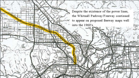 There is a lot of confusion
between the proposal for the Whitnall Freeway (which was Route 64), and an earlier, 1927 proposal for a Whitnall Parkway that
remained on planning maps until the 1960s. The figure to the right shows
the Whitnall Parkway approach; a 2014 LA Times article used words that
made this appear to be the freeway proposal from the 1960s (it clearly
isn't, as the Route 64 freeway ran across Chase and Malibu Canyon, and the
Route 258 freeway ran along Normandie). This approach connects to Route 258, along what is now "Whitnall Highway" in Burbank (which could be the
source of the naming of this route). It does not appear substantiated in
the route definitions, so this doesn't appear to be a highway at the state
level. Gordon Whitnall was involved in city planning around 1916.
Whitnall's vision for Los Angeles was both practical and idealistic. He
believed that Los Angeles' geographical location made it predestined to be
the most important city in the West. He also saw that Los Angeles was not
just L.A. proper, but the numerous other satellite cities that surrounded
it. These contiguous cities suffered from poor transportation and
scattered administrative centers. Quickly promoted to Director of City and
County Planning, he envisioned a sprawling metropolis made up of numerous
organic civic districts, linked together by a series of arterial highways,
and unified by a centrally located administrative and government center
downtown near the historic Plaza, where it would be "accessible to all."
Whitnall and the planning committee also envisioned four "highways" that
would radiate from the valley into arteries leading to the city. These
parkway/highways were more modest in design from the modern freeway, and
often featured a landscaped center strip separating opposing lanes of
traffic. They were Balboa Boulevard, San Fernando Boulevard, Remsen
Boulevard (seemingly never built), and most ambitious of all -- Whitnall
Highway. Whitnall Highway would stretch diagonally southeast by northwest
from Newhall (now part of Santa Clarita) through the San Fernando Valley,
and meet up with the entrance of a two-mile tunnel originating off
Riverside Drive (which was being expanded into a major artery linking the
valley to downtown) that would run under Griffith Park into Hollywood, via
Bronson Avenue. Had this tunnel been built it would be the longest highway
tunnel in California, and even today would rank as the third longest
highway tunnel in the USA. On June 5, 1927, the first section of Whitnall
Highway opened to a crowd of 300 at the intersection of Whitnall and
Cahuenga Boulevard. Gordon, the guest of honor, christened the highway at
the ceremony, which also celebrated the opening of 400 residential tracts
owned by the Hugh Evans Corporation. Homeowners in the projected path of
the highway began to protest the city's attempt to enforce its right of
way through their property. The road was extended, despite further
protests, to Oxnard Boulevard in 1931. Yet, after 1934, both plans for the
highway and the tunnel abruptly disappeared from the news, though
variations continued to appear on maps of proposed transit routes. Over
the years, Burbank and North Hollywood tried to figure out what to do with
the quirky wide road, and all the free public space below the giant
transmission towers which loomed overhead. Portions of the land were used
as makeshift playgrounds, parks, and bike trails, but by 1973 the city of
Burbank was at a loss. The community seemed to have little interest in
pushing for landscaping, or the creation of public parks, and the city had
a hard time commercially leasing the land, since nothing permanent could
be built under the structures. In 1989 a group of mentally challenged
people created a garden on 21 miles under the power lines. In the '90s
Burbank finally commissioned the Whitnall Highway Parks North and South.
There is a lot of confusion
between the proposal for the Whitnall Freeway (which was Route 64), and an earlier, 1927 proposal for a Whitnall Parkway that
remained on planning maps until the 1960s. The figure to the right shows
the Whitnall Parkway approach; a 2014 LA Times article used words that
made this appear to be the freeway proposal from the 1960s (it clearly
isn't, as the Route 64 freeway ran across Chase and Malibu Canyon, and the
Route 258 freeway ran along Normandie). This approach connects to Route 258, along what is now "Whitnall Highway" in Burbank (which could be the
source of the naming of this route). It does not appear substantiated in
the route definitions, so this doesn't appear to be a highway at the state
level. Gordon Whitnall was involved in city planning around 1916.
Whitnall's vision for Los Angeles was both practical and idealistic. He
believed that Los Angeles' geographical location made it predestined to be
the most important city in the West. He also saw that Los Angeles was not
just L.A. proper, but the numerous other satellite cities that surrounded
it. These contiguous cities suffered from poor transportation and
scattered administrative centers. Quickly promoted to Director of City and
County Planning, he envisioned a sprawling metropolis made up of numerous
organic civic districts, linked together by a series of arterial highways,
and unified by a centrally located administrative and government center
downtown near the historic Plaza, where it would be "accessible to all."
Whitnall and the planning committee also envisioned four "highways" that
would radiate from the valley into arteries leading to the city. These
parkway/highways were more modest in design from the modern freeway, and
often featured a landscaped center strip separating opposing lanes of
traffic. They were Balboa Boulevard, San Fernando Boulevard, Remsen
Boulevard (seemingly never built), and most ambitious of all -- Whitnall
Highway. Whitnall Highway would stretch diagonally southeast by northwest
from Newhall (now part of Santa Clarita) through the San Fernando Valley,
and meet up with the entrance of a two-mile tunnel originating off
Riverside Drive (which was being expanded into a major artery linking the
valley to downtown) that would run under Griffith Park into Hollywood, via
Bronson Avenue. Had this tunnel been built it would be the longest highway
tunnel in California, and even today would rank as the third longest
highway tunnel in the USA. On June 5, 1927, the first section of Whitnall
Highway opened to a crowd of 300 at the intersection of Whitnall and
Cahuenga Boulevard. Gordon, the guest of honor, christened the highway at
the ceremony, which also celebrated the opening of 400 residential tracts
owned by the Hugh Evans Corporation. Homeowners in the projected path of
the highway began to protest the city's attempt to enforce its right of
way through their property. The road was extended, despite further
protests, to Oxnard Boulevard in 1931. Yet, after 1934, both plans for the
highway and the tunnel abruptly disappeared from the news, though
variations continued to appear on maps of proposed transit routes. Over
the years, Burbank and North Hollywood tried to figure out what to do with
the quirky wide road, and all the free public space below the giant
transmission towers which loomed overhead. Portions of the land were used
as makeshift playgrounds, parks, and bike trails, but by 1973 the city of
Burbank was at a loss. The community seemed to have little interest in
pushing for landscaping, or the creation of public parks, and the city had
a hard time commercially leasing the land, since nothing permanent could
be built under the structures. In 1989 a group of mentally challenged
people created a garden on 21 miles under the power lines. In the '90s
Burbank finally commissioned the Whitnall Highway Parks North and South.
(Source: LA Times, 10/28/2014; KCETLost
Landmarks, 6/28/2013; Jayne Vidheecharoen/Slideshare, 4/18/2011)
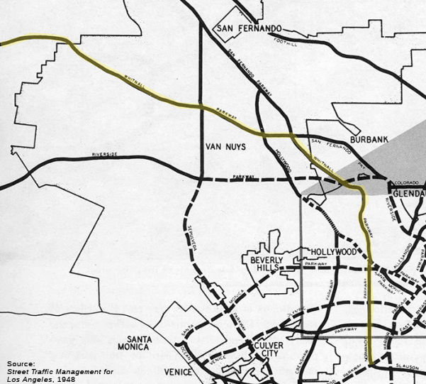 A late 1940s parkway plan shows the Whitnall Parkway in a bit more detail.
This image, from the 1948 publication Street Traffic Management for Los Angeles, shows the freeway / parkway plan that had been in the works during the 1940s (at least from
the city's perspective). It had the Whitnall Parkway following much of the
rail line across the San Fernando Valley and seemingly into Simi Valley.
At the Southeastern end, the Whitnall Parkway connected to the Normandie
Parkway (which provides some explanation for why Route 258 was also
considered part of the Whitnall Freeway).
A late 1940s parkway plan shows the Whitnall Parkway in a bit more detail.
This image, from the 1948 publication Street Traffic Management for Los Angeles, shows the freeway / parkway plan that had been in the works during the 1940s (at least from
the city's perspective). It had the Whitnall Parkway following much of the
rail line across the San Fernando Valley and seemingly into Simi Valley.
At the Southeastern end, the Whitnall Parkway connected to the Normandie
Parkway (which provides some explanation for why Route 258 was also
considered part of the Whitnall Freeway).
(Source: LA Metro Primary Resources, "Past Visions of Los Angeles’ Transportation Future: 1940s", retrieved 12/23/2023)
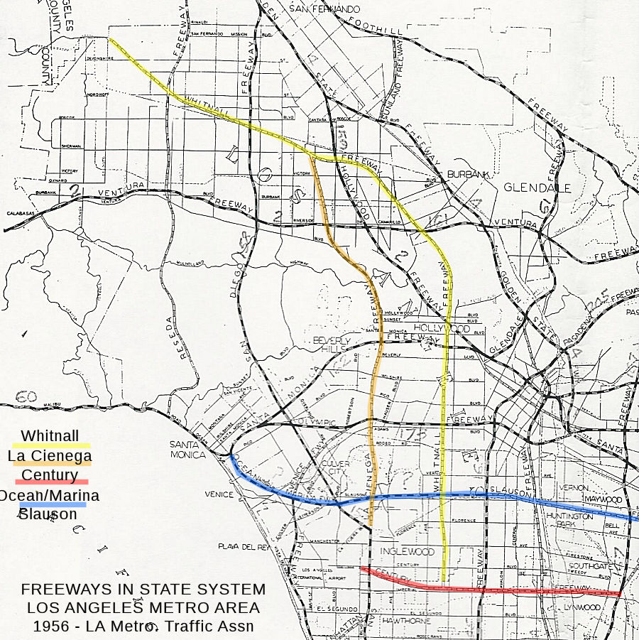 The Whitnall Freeway also appears on the Los Angeles
Metropolitan Traffic Association "Freeways in State System" map from 1956.
On this map, the Whitnall Freeway starts at the Century Freeway, near
Imperial Highway, and continues N to the W of Western Avenue (perhaps
along the line of Wilton or Van Ness) to cross over the hills into the
valley. Unlike the 1948 plans, the Whitnall did not connect with the San
Fernando Parkway but turned to cross the Hollywood Freeway extension, and
then continuing over towards Chatsworth and Stoney Point, and on into Simi
Valley and Ventura County. Also notable here is the La Cienega Freeway,
which would have continued up La Cienega, perhaps Fairfax, across Crescent
Heights and Laurel Canyon to meet the Whitnall; the La Cienega Freeway
eventually became the unbuilt Laurel Canyon Freeway and Route 170.
The Whitnall Freeway also appears on the Los Angeles
Metropolitan Traffic Association "Freeways in State System" map from 1956.
On this map, the Whitnall Freeway starts at the Century Freeway, near
Imperial Highway, and continues N to the W of Western Avenue (perhaps
along the line of Wilton or Van Ness) to cross over the hills into the
valley. Unlike the 1948 plans, the Whitnall did not connect with the San
Fernando Parkway but turned to cross the Hollywood Freeway extension, and
then continuing over towards Chatsworth and Stoney Point, and on into Simi
Valley and Ventura County. Also notable here is the La Cienega Freeway,
which would have continued up La Cienega, perhaps Fairfax, across Crescent
Heights and Laurel Canyon to meet the Whitnall; the La Cienega Freeway
eventually became the unbuilt Laurel Canyon Freeway and Route 170.
 By 1958, maps were showing the Whitnall moving closer to
the eventual Route 64 version. The 1958 Metropolitan Transportation Engineering Board (MTEB) Master Plan of Freeways and Expressways (PDF) shows that, at the city level at
least, there were plans to construct he Whitnall as a route starting at
Route 405, going approximately along the Route 258 freeway route. Crossing
US 101, where Route 258 ended, it skirted the western edge of Griffith
Park, connecting with Whitnall Highway in Burbank, and eventually
connecting with something near Route 64, the Whitnall Freeway. This
version of the Whitnall in the San Fernando Valley ran E/W, ending at the
Decker Canyon Expressway. A separate route, the Sherman Expressway
slightly to the S, ran from the Reseda Expressway (Route 14) to the Malibu
Freeway, which then ran N/S along Malibu Canyon to Route 1. This plan
appears to have led to the eventual LRN definitions for what became Route 258 and Route 64. For Route 258, the traversable route is Western Avenue,
with Caltrans having no plans to assume maintenance. The freeway routing
was never determined. The route concept report recommends that the
alignment be moved 3.5 mi westerly, and the definition be from Route 405
near LAX to Route 101 near Hollywood.
By 1958, maps were showing the Whitnall moving closer to
the eventual Route 64 version. The 1958 Metropolitan Transportation Engineering Board (MTEB) Master Plan of Freeways and Expressways (PDF) shows that, at the city level at
least, there were plans to construct he Whitnall as a route starting at
Route 405, going approximately along the Route 258 freeway route. Crossing
US 101, where Route 258 ended, it skirted the western edge of Griffith
Park, connecting with Whitnall Highway in Burbank, and eventually
connecting with something near Route 64, the Whitnall Freeway. This
version of the Whitnall in the San Fernando Valley ran E/W, ending at the
Decker Canyon Expressway. A separate route, the Sherman Expressway
slightly to the S, ran from the Reseda Expressway (Route 14) to the Malibu
Freeway, which then ran N/S along Malibu Canyon to Route 1. This plan
appears to have led to the eventual LRN definitions for what became Route 258 and Route 64. For Route 258, the traversable route is Western Avenue,
with Caltrans having no plans to assume maintenance. The freeway routing
was never determined. The route concept report recommends that the
alignment be moved 3.5 mi westerly, and the definition be from Route 405
near LAX to Route 101 near Hollywood.
(Map Source: LA Times, 10/28/2014. Note that this shows a different routing of Route 64
than some other maps, which have it terminating at the I-5/Route 64
junction. It could reflect different planning options over different
times.)
 The plans for the full Whitnall persisted at least into 1971, when a map of the
Circulation System - Santa Monica Mountains Area, Part of Mulholland Drive
Scenic Development Plan, showed what appears to be the Whitnall Parkway,
extended from the end of Western Avenue (Route 258) to Route 134 and into
Burbank, presumably to meet the Whitnall Highway in Burbank.
The plans for the full Whitnall persisted at least into 1971, when a map of the
Circulation System - Santa Monica Mountains Area, Part of Mulholland Drive
Scenic Development Plan, showed what appears to be the Whitnall Parkway,
extended from the end of Western Avenue (Route 258) to Route 134 and into
Burbank, presumably to meet the Whitnall Highway in Burbank.
(Image source: Circulation System - Santa Monica Mountains Area,
Part of Mulholland Drive Scenic Development Plan, Dated: 1971 Source:
CSUN Archives, via email from Will Poundstone, 11/29/2024)
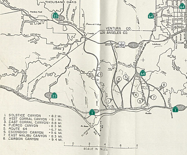 The Route 64 Malibu-Whitnall
Freeway plans were laid out in more detail in 1963. Originally, Decker
Canyon had been selected for the project in 1958 (see the MTEB map above),
but Malibu Canyon replaced it. Route 64 would have connected the Pacific
Coast Highway with US 101, traveling north via Malibu Creek. The route
would have then extended north and swung east to eventually meet Route 170
and I-5, traversing Van Nuys. The Valley part of the route changed after
the Route 118 Freeway plans were finalized. Freeway’s
supporters included most of the Valley’s Chambers of Commerce, the
San Fernando Valley Industrial Association, and Malibu land companies. The
supporters’ major concerns were overcrowded coastal highways and
taxpayers’ lack of access to the beach. Malibu residents wanted
their ingress and egress. The opposition consisted of residents from both
Malibu and the Valley, the Sierra Club, the Save Malibu Canyon Committee,
and the environment minded. The opposition critiqued the drive to
construct, coining then Governor Reagan’s phrase “the
bulldozer mentality of the past”, and fought for preservation,
reiterating the severe and irreversible damage on ecology and wildlife if
crews blocked the water stream and disfigured the mountainous terrain.
There would have been interchanges in the Malibu portion at Route 1,
Malibu Canyon Road, Cold Canyon/Piuma Road, Mulholland Highway, Lost Hills
Road, and US 101. The route would have run just to the E of existing Las
Virgenes/Malibu Canyon Road. The project hit pause in 1970 when the need
for this freeway was repeatedly questioned. Authority was deferred to
county and State Department of Parks and Recreation officials to determine
how to best use Malibu’s land. Factors for halting Route 64 included
the high cost for property acquisition, on top of the high costs of
constructing tunnels and excavating in Malibu’s mountainous terrain,
the position of the Van Nuys Airport, which the freeway had to cross, and
persistent ecological concerns.
The Route 64 Malibu-Whitnall
Freeway plans were laid out in more detail in 1963. Originally, Decker
Canyon had been selected for the project in 1958 (see the MTEB map above),
but Malibu Canyon replaced it. Route 64 would have connected the Pacific
Coast Highway with US 101, traveling north via Malibu Creek. The route
would have then extended north and swung east to eventually meet Route 170
and I-5, traversing Van Nuys. The Valley part of the route changed after
the Route 118 Freeway plans were finalized. Freeway’s
supporters included most of the Valley’s Chambers of Commerce, the
San Fernando Valley Industrial Association, and Malibu land companies. The
supporters’ major concerns were overcrowded coastal highways and
taxpayers’ lack of access to the beach. Malibu residents wanted
their ingress and egress. The opposition consisted of residents from both
Malibu and the Valley, the Sierra Club, the Save Malibu Canyon Committee,
and the environment minded. The opposition critiqued the drive to
construct, coining then Governor Reagan’s phrase “the
bulldozer mentality of the past”, and fought for preservation,
reiterating the severe and irreversible damage on ecology and wildlife if
crews blocked the water stream and disfigured the mountainous terrain.
There would have been interchanges in the Malibu portion at Route 1,
Malibu Canyon Road, Cold Canyon/Piuma Road, Mulholland Highway, Lost Hills
Road, and US 101. The route would have run just to the E of existing Las
Virgenes/Malibu Canyon Road. The project hit pause in 1970 when the need
for this freeway was repeatedly questioned. Authority was deferred to
county and State Department of Parks and Recreation officials to determine
how to best use Malibu’s land. Factors for halting Route 64 included
the high cost for property acquisition, on top of the high costs of
constructing tunnels and excavating in Malibu’s mountainous terrain,
the position of the Van Nuys Airport, which the freeway had to cross, and
persistent ecological concerns.
(Source: CSUN Special Collections: CA 64 - The Valley’s Right of Way to the Beach, 12/6/2022)
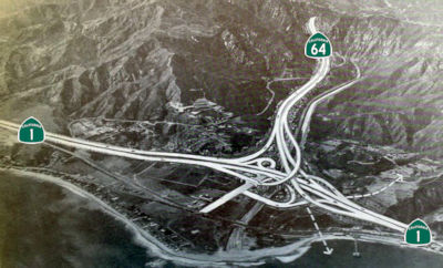 With respect to the Malibu portion of the route, Whitnall was also involved.
Whitnall recognized that Los Angeles was comprised of dozens of separate
but interconnected communities and proposed a network of four freeways
radiating from the center of Los Angeles to the satellite communities,
including the San Fernando Valley and Malibu. In 1958 plans for the
Whitnall Freeway were released with a route through Decker Canyon (see the
MTEB map above). By 1963, the route was moved to Malibu Canyon and was
officially designated Route 64. Plans emerged that included filling in the
entire canyon and building the freeway on the newly-created land. In
February 1964, the California Highway Committee held a public meeting to
discuss the plan to transform PCH into a freeway from Malibu Canyon Road
to Point Mugu. A map of the route shows the freeway running through the
middle of Malibu Park. The figure to the right, from 1963, shows the
proposed interchange with the Pacific Coast Freeway (Route 1) in Malibu. A
10-year battle ensued to stop the freeway. It became a major issue in the
fight for Malibu cityhood. Campaign material from the unsuccessful 1964
Malibu incorporation effort shows an artist’s rendering of the
Malibu Civic Center area entirely engulfed in a multilane freeway and
multiple freeway interchanges. In 1970 Malibu residents, citing ecological
and economic concerns, were able to have 7.5 miles of the proposed freeway
deleted from the master plan. Due to budget cuts and new environmental
restrictions, Whitnall Freeway fell years behind schedule.
With respect to the Malibu portion of the route, Whitnall was also involved.
Whitnall recognized that Los Angeles was comprised of dozens of separate
but interconnected communities and proposed a network of four freeways
radiating from the center of Los Angeles to the satellite communities,
including the San Fernando Valley and Malibu. In 1958 plans for the
Whitnall Freeway were released with a route through Decker Canyon (see the
MTEB map above). By 1963, the route was moved to Malibu Canyon and was
officially designated Route 64. Plans emerged that included filling in the
entire canyon and building the freeway on the newly-created land. In
February 1964, the California Highway Committee held a public meeting to
discuss the plan to transform PCH into a freeway from Malibu Canyon Road
to Point Mugu. A map of the route shows the freeway running through the
middle of Malibu Park. The figure to the right, from 1963, shows the
proposed interchange with the Pacific Coast Freeway (Route 1) in Malibu. A
10-year battle ensued to stop the freeway. It became a major issue in the
fight for Malibu cityhood. Campaign material from the unsuccessful 1964
Malibu incorporation effort shows an artist’s rendering of the
Malibu Civic Center area entirely engulfed in a multilane freeway and
multiple freeway interchanges. In 1970 Malibu residents, citing ecological
and economic concerns, were able to have 7.5 miles of the proposed freeway
deleted from the master plan. Due to budget cuts and new environmental
restrictions, Whitnall Freeway fell years behind schedule.
(Source: Malibu Surfside News, 4/22/2015, which also quotes this site; Facebook 11/25/2017; KCET Lost Landmarks, 6/28/2013)
Sign Route 64 was not defined as part of the initial state signage of routes in 1934. It is unclear what (if any) route was signed as Sign Route 64 between 1934 and 1964.
 Status
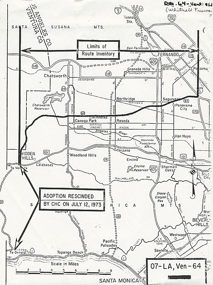 This route is unconstructed. The traversable local routing between Route 1 and US 101 is
Malibu Canyon Road; this portion was deleted from the Freeway and
Expressway system on 11/23/1970. There is no traversable local routing
between US 101 and Route 27. Between Route 27 and I-5, the traversable
local route is along Roscoe Blvd and Tuxford St. The portion between US 101 and I-5 was deleted from the Freeway and Expressway system on
1/1/1976. The route concept report recommends deletion of the route from
the highway system.
This route is unconstructed. The traversable local routing between Route 1 and US 101 is
Malibu Canyon Road; this portion was deleted from the Freeway and
Expressway system on 11/23/1970. There is no traversable local routing
between US 101 and Route 27. Between Route 27 and I-5, the traversable
local route is along Roscoe Blvd and Tuxford St. The portion between US 101 and I-5 was deleted from the Freeway and Expressway system on
1/1/1976. The route concept report recommends deletion of the route from
the highway system.
The 2013 Traversable Highway report notes:
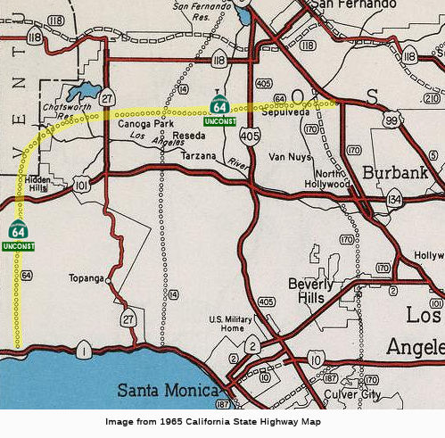
This route isn't signed. It was assigned to what would have been the Malibu Canyon Freeway / Whitnall Freeway (on planning maps in 1965, shown on AAA maps as late as the mid 1980s), which left Route 5 near the Route 170/Route 5 junction, continued across the San Fernando Valley, crossing Van Nuys Blvd near Parthenia, Sepulveda near Chase, ending up about the level of Saticoy or Strathern. Just W of Bell Canyon, it turned to intersect the US 101 Freeway around Hidden Hills. It then crossed the Malibu hills approx. across Malibu Canyon (Las Virgenes) Road. The routing for this was never determined, and there is no assigned traversable route. The limits of the route inventory as of the 1970s was between US 101 and Route 5. The portion between US 101 and Route 1 had its adoption rescinded by the CHC on July 12, 1973. There is a nice discussion on the AARoads Forum that shows it on some maps of the era.
 Naming
This would have been named the "Malibu Canyon Freeway" for the portion across Malibu Canyon, and the "Whitnall Freeway" for the portion across the San Fernando Valley. Maps based on the 1956 freeway plan show the route dividing at I-405. The Whitnall Freeway continued S (likely as Route 258) to go through Burbank, and then down along Western to Torrance. The remainder of Route 64 then continued to the Route 170/I-5 interchange. This was shown as the "Sunland Freeway".
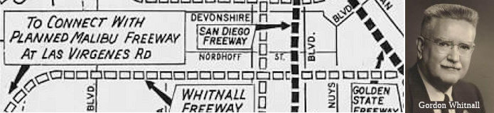 The Whitnall Freeway was named for Gordon Whitnall, the former Los Angeles city director of planning. Part of
the reason for the naming could be that the route ran along Whitnall
Highway, an unusual divided street that was laid out in 1927 to be
part of a parkway network envisioned to dissect the Valley. In 1913,
Gordon Whitnall founded the Los Angeles City Planning Association, and in
1920, he established the Los Angeles City Planning Department. From
1920-1930, he was Director of Planning for Los Angeles, and from 1929-1930
was president of the League of California Cities. From 1932-1935 he was
the coordinator of the Committee on Government Simplification for Los
Angeles County. In 1941, Gordon and Brysis Whitnall established a planning
and government consulting firm in Los Angeles. Gordon Whitnall was an
instructor in Planning at the University of Southern California, and a
member of the American Society of Planning Officials, the American
Institute of Planners, the American Society of Consulting Planners, and
the International Fraternity of Lambda Alpha, Los Angeles Chapter.
The Whitnall Freeway was named for Gordon Whitnall, the former Los Angeles city director of planning. Part of
the reason for the naming could be that the route ran along Whitnall
Highway, an unusual divided street that was laid out in 1927 to be
part of a parkway network envisioned to dissect the Valley. In 1913,
Gordon Whitnall founded the Los Angeles City Planning Association, and in
1920, he established the Los Angeles City Planning Department. From
1920-1930, he was Director of Planning for Los Angeles, and from 1929-1930
was president of the League of California Cities. From 1932-1935 he was
the coordinator of the Committee on Government Simplification for Los
Angeles County. In 1941, Gordon and Brysis Whitnall established a planning
and government consulting firm in Los Angeles. Gordon Whitnall was an
instructor in Planning at the University of Southern California, and a
member of the American Society of Planning Officials, the American
Institute of Planners, the American Society of Consulting Planners, and
the International Fraternity of Lambda Alpha, Los Angeles Chapter.
(Source: Some information from Cornell University Library; Image source: Los Angeles Times, 11/5/1961 via Joel Windmiller, 1/18/2023, MyBurbank)
 Other WWW Links
 Statistics
Overall statistics for Route 64:
 Pre-1964 Legislative Route
The route that would become LRN 64 was first defined in the 1919 Third Bond Act as running from Mecca to Blythe. Mecca is S of Indio, near where present-day Route 86 (former US 99) and Route 111 diverge around the Salton Sea. The route ran across Box Canyon Road to join the current I-10 (former US 60/US 70) routing to Blythe. Note that this route had no connection to the remainder of the state highway system, nor to the state line, at the time (i.e., it didn't connect to LRN 26 in Indio/Mecca, nor did it extend to Arizona).
In 1931, Chapter 82 extended the route from Blythe to California-Arizona state line at the Colorado River and [LRN 64] to [LRN 26] near Indio. It was felt that, as a link in the transcontinental routing, the state route should extend from the state line to a conneciton with some other state route. It was noted in 1931 that approval of the requests of Arizona and California to place this route on the federal aid system had been granted by the Secretary of Agriculture. The bypass of Box Canyon opened in 1935.
In 1933, the route was extended further with two segments: (a) [LRN 2] near San Juan Capistrano to [LRN 77] near Lake Elsinore, and (b) [LRN 78] near Perris to [LRN 26] near Indio. Thus, in 1935, the route was codified as:
This definition was rapidly changed by Chapter 274 to make the last segment "A point near Shaver's Summit on that portion..."
In 1951, Chapter 1562 added the segment between LRN 77 near Lake Elsinore and LRN 78 near Perris to LRN 64, thus extending the first segment to terminate at LRN 78 near Perris.
This route was signed as follows:
 The portion of this route from the Arizona State Line to LRN 26 was part of the Atlantic & Pacific Highway.
© 1996-2024 Daniel P. Faigin.
Maintained by: Daniel P. Faigin
<webmaster@cahighways.org>.
 From Route
  Route 63
 Route 65