
 California Highways:
Click here for a key to the symbols used. An explanation of acronyms may be found at the bottom of the page.
 Routing
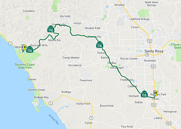 From Route 1 near Jenner to Route 101 near Cotati.
 Post 1964 Signage History
This segment is unchanged from its 1963 definition.
 Pre 1964 Signage History
The portion of this route between Jenner and Sebastopol was signed as Route 12 between the original signage of routes in 1934 and 1964. The entirety between Jenner and Cotati was LRN 104, defined in 1933.
On AARoads, Scott Parker explained why Route 116 was created: It seems
that the 1964 decision to replace Route 12 from Jenner to Sebastopol with
Route 116 was because the Bodega Bay-Sebastopol route -- part of the
Freeway & Expressway System additions -- as a LRN 51 western extension
dating from the system's original 1959 iteration -- was considered to be
the more direct and favorable route to reach the coast, as well as serving
Bodega Bay, considered to be a more popular tourist destination than
Guerneville or Jenner. The avoidance of a Route 12/Route 116 "bump" at
Sebastopol was a prime consideration as well, along with the periodic
flooding of then-LRN 104 through the Guerneville-Monte Rio area along the
lower Russian River canyon. So the renumbering took place and Route 12
signage terminated at CA 116 as it does today -- but plans were afoot to
bring the county road (Bodega Highway), which intersected Route 1 near the
small community of Bodega, into the state system in short order. But
residents in the western part of Sebastopol voiced objections to the state
assuming maintenance and signing the road because of the potential for
increased traffic through their neighborhoods, preferring (at the time) a
realignment to the south. The Division of Highways didn't demur to that
request, and Sonoma County elected to not cede the existing route to the
state. That situation, dating from around 1970, has never been resolved,
and Route 12 continues to terminate in Sebastopol as a result.
(Source: Scott Parker (Sparker) on AARoads, "Re: CA 116", 1/23/2020)
 Duncan Mills Adoption") In 1960, the CTC adopted a new routing for Route 12 (Route 116) between ¼ mi W
of Duncan Mills (~ SON 3.254) and ¼ mi E of Austin Creek (~ SON
5.368). The adopted route was 1 mi shorter than the existing route,
running between the existing highway and the Russian River, eliminating a
number of sharp curves and steep grades. It provides for a new bridge at
Austin Creek downstream from the earlier narrow structure. The route
replaced appears to have included Old Duncans Grade Road, Austin Creek
Road, and B Street in Duncan Mills.
In 1960, the CTC adopted a new routing for Route 12 (Route 116) between ¼ mi W
of Duncan Mills (~ SON 3.254) and ¼ mi E of Austin Creek (~ SON
5.368). The adopted route was 1 mi shorter than the existing route,
running between the existing highway and the Russian River, eliminating a
number of sharp curves and steep grades. It provides for a new bridge at
Austin Creek downstream from the earlier narrow structure. The route
replaced appears to have included Old Duncans Grade Road, Austin Creek
Road, and B Street in Duncan Mills.
(Source: Press Democrat, 6/26/1960, via Joel Windmiller, 1/27/2023)
 Status
Monte Rio Bridge (County Road, near 04-Son-116 7.748)
In July 2016, it was reported that Caltrans would be
replacing the Monte Rio Bridge over the Russian River (~ SON 7.79), which
is near Route 116 on Bohemian Way in Monte Rio. The 1934 bridge is nearing
the end of its life, and county officials are gearing up to decide how to
replace it, as soon as can be feasibly done. Caltrans has set aside about
$20 million in federal highway funds for the project, and the Sonoma
County Transportation & Public Works Department is expected to award
an engineering contract this summer for studies and design work that will
guide decision-making over the next year or so. The overall completion
time is likely to be five years at least. The existing bridge will still
be in service while construction is underway means the new structure
can’t be in the same location as the old one, likely raising
right-of-way issues requiring negotiation. Special considerations related
to the river environment and wildlife habitat protections also will
complicate matters. In addition to concerns about the effects of stress on
82-year-old materials, the 772-foot bridge is seismically deficient and
vulnerable to erosion and other structural inadequacies. Instead of
anchored in bedrock, as the new bridge would be, its piers were built on
wooden piles dug into the riverbed, where scouring and erosion have
exposed some of the piles. It is vulnerable to collapse in a severe
earthquake, and the ground it’s built on is subject to liquefaction,
as well. The bridge, located within 15 miles of three major earthquake
faults, was identified by the state in 1997 as needing mandatory
retrofits. The community would like to salvage the bridge for pedestrians
and bicycles, but county officials say it’s not feasible to do so
because its not the weight of the cars and trucks that are the problem,
it's the underpinnings.
(Source: Press Democrat, 6/30/2016)
In August 2023, it was reported that Caltrans has
scrapped plans to replace the Bohemian Highway Bridge in Monte Rio,
leaving Sonoma County officials scrambling to determine how to upgrade the
89-year-old span across the Russian River. Caltrans notified the county
that skyrocketing costs, now estimated at $88 million, made it infeasible
for the agency to fund a full bridge replacement. The cost includes
utility relocation and environmental work. Instead, Caltrans is offering
about $25 million in state and federal funding to retrofit the iconic
green bridge and “is committed to working with the county to help
identify other potential funding sources.” But there appears to have
been a significant communication gap in the process that led to the
decision, as well as uncertainty about how local and state agencies could
have such drastically differing expectations for the project cost. The
original estimate for the project was just under $15 million in 2013. By
2018, it had risen to around $25 million. Caltrans was prepared to go
along with that. But when the final cost estimate arrived and had
“ballooned” to $80 million-plus, it generated alarm in the
department. Christened in 1934 with vodka and Champagne at a dedication
ceremony attended by then-California Gov. Frank Merriam, the bridge has
long stood as the focal point of Monte Rio, an unincorporated town divided
by the Russian River. It is designated a Sonoma County Historic Landmark.
But the ground on which it stands is vulnerable to liquefaction. Scouring
and erosion around the wooden piles in the riverbed that support it are a
problem, as well. Located within 15 miles of three major earthquake
faults, the bridge was identified by the state in 1997 as needing
mandatory retrofits. Metal fatigue and aging concrete are additional
concerns, as is potential flooding. Moreover, the narrow bridge has
inadequate shoulders and lacks any way for pedestrians and cyclists to
cross. Buses and large vehicles trying to cross must wait at one end for
both lanes to clear before proceeding across. Other drivers routinely clip
their side mirrors, leaving shattered glass on the bridge deck. Though it
carries a county highway, the span — like others in California
— is inspected by the state and eligible for Caltrans funding, in
part through the seismic retrofit program. But a retrofit was ultimately
discarded in favor of replacement because, while more costly, a new bridge
would have a service life of 75 years or more. Rehabilitation of the
existing truss bridge only extends its life span 15 to 20 years, according
to a formal evaluation of the project published last year.
(Source: Press Democrat, 8/24/2023)
In June 2015, the CTC approved for future consideration of funding a project in Sonoma County that will construct a 163-foot retaining wall on Route 116 near the town of Guerneville (~ SON R12.233). The project is programmed in the 2014 State Highway Operation and Protection Program. The estimated cost is $6,616,000 for capital and support. Construction is estimated to begin in Fiscal Year 2015-16. The scope, as described for the preferred alternative, is consistent with the project scope programmed by the Commission in the 2014 State Highway Operation and Protection Program.
In January 2013, the CTC authorized relinquishement of right of way along Route 116 from Drake Road to Mays Canyon Road (~ SON R12.425 to SON R12.567) near the town of Guerneville, in the county of Sonoma, consisting of collateral facilities.
In February 2013, it was reported that there are plans to install a
roundabout at Route 116 at Mirabel Road in Forestville (~ SON 19.389). The
modern roundabout usually features a one-lane traffic circle in which
vehicles move counterclockwise around a center circular island, entering
and exiting to the right. The motorist entering the roundabout usually
must yield to traffic already circling.
(Source: Press-Democrat, 2/8/2013)
Jones Creek Bridge, Blucher Creek Bridge, and Gossage Creek Bridge Widening (04-Son-116, PM 19.90/33.37)
 In December 2023, the CTC approved for future consideration of funding the
following project for which a Negative Declaration (ND) has been
completed: Route 116 in Sonoma County. Replace and upgrade bridge railings
at three locations: Jones Creek Bridge, Blucher Creek Bridge, and Gossage
Creek Bridge, along Route 116. The project will also include removing and
replacing one culvert and cleaning out another culvert at Jones Creek
Bridge and widening Blucher Creek Bridge by 1.5 feet on either side, in
Sonoma County. (04-Son-116, PM 19.90/33.37; PPNO 2028P). The project is
currently programmed in the 2022 State Highway Operation and Protection
Program (SHOPP). The total programmed amount which includes Right of Way
(Support and Capital), and Construction (Support and Capital) is
$9,440,000. Construction is estimated to begin 2024-25. The scope, as
described for the preferred alternative, is consistent with the project
scope as programmed by the Commission in the 2022 SHOPP.
In December 2023, the CTC approved for future consideration of funding the
following project for which a Negative Declaration (ND) has been
completed: Route 116 in Sonoma County. Replace and upgrade bridge railings
at three locations: Jones Creek Bridge, Blucher Creek Bridge, and Gossage
Creek Bridge, along Route 116. The project will also include removing and
replacing one culvert and cleaning out another culvert at Jones Creek
Bridge and widening Blucher Creek Bridge by 1.5 feet on either side, in
Sonoma County. (04-Son-116, PM 19.90/33.37; PPNO 2028P). The project is
currently programmed in the 2022 State Highway Operation and Protection
Program (SHOPP). The total programmed amount which includes Right of Way
(Support and Capital), and Construction (Support and Capital) is
$9,440,000. Construction is estimated to begin 2024-25. The scope, as
described for the preferred alternative, is consistent with the project
scope as programmed by the Commission in the 2022 SHOPP.
(Source: December 2023 CTC Agenda, Agenda Item 2.2c.(1))
In December 2023, the CTC approved the following SHOPP
SB1 preconstruction-phase allocation:. $2,302,000. 04-Son-116 19.9/33.4.
PPNO 04-2028P; ProjID 0419000011; EA 2Q420. Route 116 Near Sebastopol, at
Jones Creek Bridge № 20-0094 (PM 19.90), Blucher Creek Bridge
№ 20-0103 (PM 29.83) and Gossage Creek Bridge № 20-0104 (PM
33.37). Upgrade bridge rails. Concurrent consideration of funding
under Resolution E-23-144; December 2023. Six month allocation time
extension for PS&E and R/W Sup approved under Waiver 23-72; June 2023.
Programmed (Allocation, if different): PS&E
$1,780,000 ($2,100,000); R/W Sup $170,000 ($202,000).
(Source: December 2023 CTC Agenda, Agenda Item 2.5b.(2b) #3)
Madrone Ave Safety Improvements
In October 2012, the CTC approved for future consideration of funding a project that will install left-turn pockets in both directions from Route 116 to Madrone Avenue (~ SON 34.287); including widening the roadway, modifying part of the existing unlined drainage gutter, and installing a new longitudinal pipe. The project is programmed in the 2010 State Highway Operation and Protection Program. The total estimated cost is $1,560,000 for capital and support. Construction is estimated to begin in Fiscal Year 2012-13. The scope, as described for the preferred alternative, is consistent with the project scope programmed in the 2010 State Highway Operation and Protection Program. A copy of the MND has been provided to Commission staff. The project will mitigate potential impacts to biological resources to a less than significant level. Proposed mitigation measures include pre-construction surveys for the California Tiger salamander, a California listed endangered species. A qualified biological monitor will be on site to insure practices are put in place to best protect the California Tiger salamander. As a result, a MND was completed for this project.
In December 2012, Caltrans wrapped up a six-month safety improvement project on Route 116 and Madrone Avenue (~ SON 34.287) in Cotati. The $690,000 project added 350-foot left-turn pockets in each direction of Route 116 at Madrone Avenue and a 5-foot shoulder on the south side of the intersection.
 Naming
 The five-mile segment of Rout 116 immediately south of the junction of Route 1 (presumably SON 0.000 to
SON 5.000, but Route 116 doesn't go S from Route 1), in the County of
Sonoma, is officially designatedthe "Deputy Sheriff Merrit W. Deeds
Memorial Highway". It was named in memory of Deputy Sheriff Merrit
W. Deeds,born in 1943 in Rohnerville, California. Deeds grew up in Sonoma
County, and graduated from Healdsburg High School in 1960. Merrit W. Deeds
joined the United States Army in 1964 and served in Vietnam in the 81st
Airborne Infantry Division. Merrit W. Deeds first served with the Sonoma
County Sheriff’s Office in 1970 as a Summer Deputy and was assigned
to the Guerneville Substation. After graduating from Sacramento State
University, Merrit W. Deeds moved to Alaska to attend the Alaska State
Trooper Academy and, upon graduation from the academy, became an Alaska
State Trooper. Merrit W. Deeds moved back to California in 1975 with his
wife and again became a Summer Deputy for the Sonoma County
Sheriff’s Office on May 23, 1975. On August 23, 1975, the Sonoma
County Sheriff’s Office notified Merrit W. Deeds that he was to
become a permanent, full-time Deputy Sheriff with the sheriff’s
office. Only hours after this notification, Deputy Sheriff Deeds was
patrolling Route 116 near Jenner when he stopped to talk with three men
who were parked on the side of the road. The driver of the vehicle fired
two shots at Deputy Sheriff Deeds, the second of which was fatal. Reserve
Deputy Rex Nance, who was off duty, stopped to assist, and Deputy Sheriff
Deeds was able to warn him that the driver had a gun, possibly saving
Reserve Deputy Nance’s life. At 32 years of age, Deputy Sheriff
Deeds sacrificed his life in meritorious service for the residents of the
County of Sonoma and the State of California. It was named by Assembly
Concurrent Resolution 159, Resolution Chapter 177, 9/11/2014.
The five-mile segment of Rout 116 immediately south of the junction of Route 1 (presumably SON 0.000 to
SON 5.000, but Route 116 doesn't go S from Route 1), in the County of
Sonoma, is officially designatedthe "Deputy Sheriff Merrit W. Deeds
Memorial Highway". It was named in memory of Deputy Sheriff Merrit
W. Deeds,born in 1943 in Rohnerville, California. Deeds grew up in Sonoma
County, and graduated from Healdsburg High School in 1960. Merrit W. Deeds
joined the United States Army in 1964 and served in Vietnam in the 81st
Airborne Infantry Division. Merrit W. Deeds first served with the Sonoma
County Sheriff’s Office in 1970 as a Summer Deputy and was assigned
to the Guerneville Substation. After graduating from Sacramento State
University, Merrit W. Deeds moved to Alaska to attend the Alaska State
Trooper Academy and, upon graduation from the academy, became an Alaska
State Trooper. Merrit W. Deeds moved back to California in 1975 with his
wife and again became a Summer Deputy for the Sonoma County
Sheriff’s Office on May 23, 1975. On August 23, 1975, the Sonoma
County Sheriff’s Office notified Merrit W. Deeds that he was to
become a permanent, full-time Deputy Sheriff with the sheriff’s
office. Only hours after this notification, Deputy Sheriff Deeds was
patrolling Route 116 near Jenner when he stopped to talk with three men
who were parked on the side of the road. The driver of the vehicle fired
two shots at Deputy Sheriff Deeds, the second of which was fatal. Reserve
Deputy Rex Nance, who was off duty, stopped to assist, and Deputy Sheriff
Deeds was able to warn him that the driver had a gun, possibly saving
Reserve Deputy Nance’s life. At 32 years of age, Deputy Sheriff
Deeds sacrificed his life in meritorious service for the residents of the
County of Sonoma and the State of California. It was named by Assembly
Concurrent Resolution 159, Resolution Chapter 177, 9/11/2014.
(Image source: Patch)
The portion between the intersection with River Road in Guerneville and US 101 in Cotati is called lots of confusing things. East of US 101 in Petaluma to its terminus at Route 121 near Schellville, the picture is a little clearer. Route 116 is called "Stage Gulch Road" until the intersection with Arnold Drive, then most people call it, and receive mail on it, as "Arnold Drive" until the terminus.
 Route 116 in Sonoma County from
Sebastopol to Forestville is named the "Willard F. Libby Memorial
Highway". Dr. Willard Frank Libby (December 17, 1908 –
September 8, 1980), a native of the Sebastopol area. He was a nuclear
scientist and member of the Atomic Energy Commission. He was an American
physical chemist noted for his role in the 1949 development of radiocarbon
dating, a process which revolutionized archaeology and palaeontology. For
his contributions to the team that developed this process, Libby was
awarded the Nobel Prize in Chemistry in 1960. A 1927 chemistry graduate of
the University of California, Berkeley, from which he received his
doctorate in 1933, he studied radioactive elements and developed sensitive
Geiger counters to measure weak natural and artificial radioactivity.
During World War II he worked in the Manhattan Project's Substitute Alloy
Materials (SAM) Laboratories at Columbia University, developing the
gaseous diffusion process for uranium enrichment. After the war, Libby
accepted professorship at the University of Chicago's Institute for
Nuclear Studies, where he developed the technique for dating organic
compounds using carbon-14. He also discovered that tritium similarly could
be used for dating water, and therefore wine. In 1950, he became a member
of the General Advisory Committee (GAC) of the Atomic Energy Commission
(AEC). He was appointed a commissioner in 1954, becoming its sole
scientist. He sided with Edward Teller on pursuing a crash program to
develop the hydrogen bomb, participated in the Atoms for Peace program,
and defended the administration's atmospheric nuclear testing. Libby
resigned from the AEC in 1959 to become Professor of Chemistry at
University of California, Los Angeles (UCLA), a position he held until his
retirement in 1976. In 1962, he became the Director of the University of
California statewide Institute of Geophysics and Planetary Physics (IGPP).
He started the first Environmental Engineering program at UCLA in 1972,
and as a member of the California Air Resources Board, he worked to
develop and improve California's air pollution standards. Named by
Assembly Concurrent Resolution 149, Chapt 128 in 1984.
Route 116 in Sonoma County from
Sebastopol to Forestville is named the "Willard F. Libby Memorial
Highway". Dr. Willard Frank Libby (December 17, 1908 –
September 8, 1980), a native of the Sebastopol area. He was a nuclear
scientist and member of the Atomic Energy Commission. He was an American
physical chemist noted for his role in the 1949 development of radiocarbon
dating, a process which revolutionized archaeology and palaeontology. For
his contributions to the team that developed this process, Libby was
awarded the Nobel Prize in Chemistry in 1960. A 1927 chemistry graduate of
the University of California, Berkeley, from which he received his
doctorate in 1933, he studied radioactive elements and developed sensitive
Geiger counters to measure weak natural and artificial radioactivity.
During World War II he worked in the Manhattan Project's Substitute Alloy
Materials (SAM) Laboratories at Columbia University, developing the
gaseous diffusion process for uranium enrichment. After the war, Libby
accepted professorship at the University of Chicago's Institute for
Nuclear Studies, where he developed the technique for dating organic
compounds using carbon-14. He also discovered that tritium similarly could
be used for dating water, and therefore wine. In 1950, he became a member
of the General Advisory Committee (GAC) of the Atomic Energy Commission
(AEC). He was appointed a commissioner in 1954, becoming its sole
scientist. He sided with Edward Teller on pursuing a crash program to
develop the hydrogen bomb, participated in the Atoms for Peace program,
and defended the administration's atmospheric nuclear testing. Libby
resigned from the AEC in 1959 to become Professor of Chemistry at
University of California, Los Angeles (UCLA), a position he held until his
retirement in 1976. In 1962, he became the Director of the University of
California statewide Institute of Geophysics and Planetary Physics (IGPP).
He started the first Environmental Engineering program at UCLA in 1972,
and as a member of the California Air Resources Board, he worked to
develop and improve California's air pollution standards. Named by
Assembly Concurrent Resolution 149, Chapt 128 in 1984.
(Image source: Wikipedia)
 Scenic Route
[SHC 263.6] Entire portion.
 Freeway
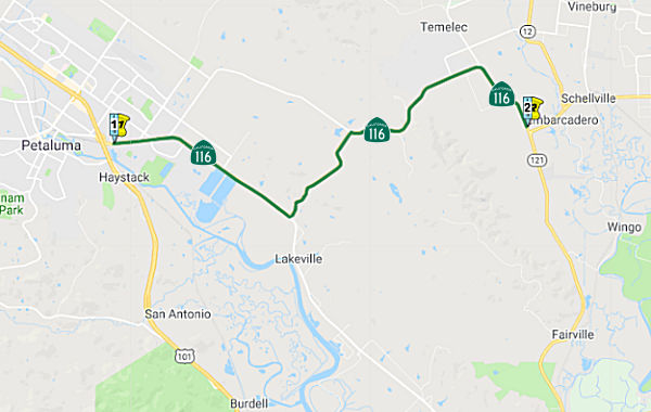 From Route 101 near Petaluma to Route 121 near Schellville.
Post 1964 Signage HistoryThis segment is unchanged from its 1963 definition.
Pre 1964 Signage HistoryThis was LRN 104, defined in 1933. It does not appear to have been a signed route prior to 1964.
StatusIn May 2014, the CTC approved for future consideration of funding a project project in Sonoma County that will repair embankment on a portion of Route 116 near the city of Petaluma. The project is programmed in the 2014 State Highway Operation and Protection Program. The total estimated cost is $2,420,000 for capital and support. Construction is estimated to begin in Fiscal Year 2014-15.
Stage Gulch Road/Lakeville Highway Intersection Safety Project (04-Son-116 39.3)
 In June 2020, the CTC amended the following project into
the SHOPP: 04-Son-116 39.3. PPNO 2028S. ProjID 0419000047. EA 2Q770. Route 116 near Petaluma, at the intersection with Lakeville Highway.
Intersection improvements. PA&ED $1,877K; PS&E $2,065K; RW Sup
$435K; Con Sup $1,954K; R/W Cap $755K; Const Cap $5,144K; Total $12,230K.
BC: 9/2/2024.
In June 2020, the CTC amended the following project into
the SHOPP: 04-Son-116 39.3. PPNO 2028S. ProjID 0419000047. EA 2Q770. Route 116 near Petaluma, at the intersection with Lakeville Highway.
Intersection improvements. PA&ED $1,877K; PS&E $2,065K; RW Sup
$435K; Con Sup $1,954K; R/W Cap $755K; Const Cap $5,144K; Total $12,230K.
BC: 9/2/2024.
(Source: June 2020 CTC Agenda, Agenda Item
2.1a.(5a) #7)
In June 2020, the CTC approved the following support
allocation for this project: 04-Son-116 39.3 PPNO 2028S ProjID 0419000047
EA 2Q770. Route 116 near Petaluma, at the intersection with Lakeville
Highway. Intersection improvements. Allocation: PA&ED $1,877,000
(Concurrent Amendment under SHOPP Amendment 18H-018; June 2020.)
(Source: June 2020 CTC Agenda, Agenda Item
2.5b.(2a) #28)
In June 2023, the CTC approved for future consideration
of funding 05-04-Son-116, PM 39.3. Stage Gulch Road/Lakeville Highway
Intersection Safety Project. Improve safety at the Stage Gulch
Road/Lakeville Highway Intersection on Route 116, in Sonoma County. (PPNO
2028S). The project is located on Route 116 at postmile 39.3, in Sonoma
County. The Department proposes to perform intersection improvements at
the Stage Gulch Road/Lakeville Highway intersection on Route 116. The
project is currently programmed in the 2022 SHOPP for a total of
$12,230,000, which includes Right of Way (Support and Capital) and
Construction (Support and Capital). Construction is estimated to begin
2024-25. The scope, as described for the preferred alternative, is
consistent with the project scope as programmed by the Commission in the
2022 SHOPP. A copy of the ND has been provided to Commission staff. The
project will result in less than significant impacts to the environment.
As a result, a ND was completed for this project.
(Source: June 2023 CTC Agenda, Agenda Item 2.2c.(1) Item 5)
In June 2023, the CTC approved the following amendment
to a project already in the 2022 SHOPP: 04-Son-116 39.3. PPNO 04-2028S;
ProjID 0419000047; EA 2Q770. Route 116 Near Petaluma, at the intersection
with Lakeville Highway. Intersection improvements Construct
roundabout. Note: Increase Right of Way Capital and Construction
Support and Capital to construct roundabout. Delay delivery year to
allow time to complete necessary R/W acquisitions. Allocation Changes ($
× 1,000): Con Sup $1,954 $2,854; R/W
Cap $755 $854; Const Cap $5,144
$7,458; TOTAL $12,230 $15,543. FY23-24
FY24-25.
(Source: June 2023 CTC Agenda, Agenda Item 2.1a.(2d) #12)
In June 2023, the CTC approved the following SHOPP
Pre-Construction Phase (environmental support, design, and R/W support)
allocation: $2,955,000. 04-Son-116 39.3. PPNO 04-2028S; ProjID 0419000047;
EA 2Q770. Route 116 Near Petaluma, at the intersection with Lakeville
Highway. Intersection improvements. Concurrent consideration of
funding under Resolution E-23-85; June 2023. Twelve month allocation time
extension for PS&E and R/W Sup approved under Waiver 22-73; June 2022.
Allocation (Programmed / Allocated): PS&E $2,065,000
/ $2,437,000; R/W Sup $435,000 / $518,000.
(Source: June 2023 CTC Agenda, Agenda Item 2.5b.(2a) #8)
In February 2012, the CTC authorized $2,999,000 to provide Environmental Mitigation for the Stage Gulch Road Curve Correction and Realignment project near Petaluma, from Adobe Road to west of Arnold Drive (~ SON 42.504). EA 04-28381, PPNO 0832 to meet the requirements of permits issued by the regulatory agencies.
In February 2013, it was reported that there are plans to install
roundabouts at Arnold Drive at Agua Caliente Road (~ SON 44.799) at the
entrance to the Hanna Boys Center in Sonoma. A roundabout also is being
considered for the three-way intersection of Route 116 and Route 121/Route 12 in Carneros, south of Sonoma. The modern roundabout usually features a
one-lane traffic circle in which vehicles move counterclockwise around a
center circular island, entering and exiting to the right. The motorist
entering the roundabout usually must yield to traffic already circling.
(Source: Press-Democrat, 2/8/2013)
Route 116/Route 121 Roundabout (~ SON 46.741)
 In December 2014, it was reported that the state is moving ahead with plans that call for a
possible two-lane roundabout or traffic signal at the intersection of
Route 116 and Route 121. Officials are still assessing environmental and
other impacts, such as a noise, for both options before they can move
ahead with designs. They’re also meeting with business and vineyard
owners, who could see some encroachment if a roundabout is built. If
approved, construction could start around 2019-2020. It’s taken so
long to deal with the crossing at Route 116 and Route 121 in part because
of the number of government agencies involved. The plans also call for
sidewalks up to 10 feet wide, which would accommodate both pedestrians and
bicyclists. An existing park-and-ride lot could be relocated and the
nearby bridge over Yellow Creek replaced.
In December 2014, it was reported that the state is moving ahead with plans that call for a
possible two-lane roundabout or traffic signal at the intersection of
Route 116 and Route 121. Officials are still assessing environmental and
other impacts, such as a noise, for both options before they can move
ahead with designs. They’re also meeting with business and vineyard
owners, who could see some encroachment if a roundabout is built. If
approved, construction could start around 2019-2020. It’s taken so
long to deal with the crossing at Route 116 and Route 121 in part because
of the number of government agencies involved. The plans also call for
sidewalks up to 10 feet wide, which would accommodate both pedestrians and
bicyclists. An existing park-and-ride lot could be relocated and the
nearby bridge over Yellow Creek replaced.
(Source: Press-Democrat, 12/21/2014; Image source: Adapted from Sonoma County Gazette, 5/15/2020)
The 2020 SHOPP, approved in May 2020, included the
following NEW Mobility item of interest: 04-Sonoma-121 PM 6.5/7.0 PPNO
2031J Proj ID 0412000557 EA 3G900. Route 121 near Schellville, at the
intersection of Routes 121 and 116. Construct roundabout. Programmed in
FY22-23, with construction scheduled to start in March 2023. Total project
cost is $18,869K, with $16,819K being capital (const and right of way) and
$2,050K being support (engineering, environmental, etc.).
(Source: 2020 Approved SHOPP a/o May 2020)
In May 2020, it was reported that CTC approved the 2020
SHOPP, which included funding in the amount of $19M to complete
improvements at the intersection of Route 116 and Route 121 southwest of
the City of Sonoma. The money will become available in 2022. Measure M,
the ¼-cent sales tax for transportation, was used to leverage the
state dollars in order to fully fund the improvements. Measure M is
contributing $5M. The project will improve traffic circulation and safety
for all users and reduce congestion by removing the current stop
sign-controlled intersection and installing a roundabout at the
intersection of Highway 121 and 116. The project will also widen the
roadway to allow for turn lanes into and out of existing commercial uses.
The Park and Ride lot will be relocated; the parking capacity will remain
the same in the new location. SCTA serves as the project sponsor and
Caltrans will build the project. The current cost estimate for this
project is $24 million, and construction is currently scheduled to start
in early 2023. The environmental documentation for compliance with the
National Environmental Protection Act / California Environmental Quality
Act (NEPA/CEQA) and project approval was completed in April 2018. Design
and right of way phases are underway and will be completed by 2022.
(Source: Sonoma County Gazette, 5/15/2020)
The roundabout is part three of a five-part Sonoma
County Transportation Authority 'local streets' project to improve traffic
conditions along Arnold Drive (Route 116, and continuation of the street N
of the point Route 116 turns off onto Stage Gulch Road), funded by Measure
M, the quarter-cent sales tax for transportation improvements passed by
county voters in 2004. The first part of the Arnold Drive project was
widening the two-lane road's shoulders just south of Glen Ellen (off the
state highway system, near Route 12), which was completed in 2012. The
second part was the Hap Arnold Roundabout at the intersection of Agua
Caliente Road (off the state highway system), completed in 2014. Note that
the SHOPP grant for this project won't become available until 2022, when
Sonoma County Transportation Authority supplies the additional $5 million
in sales tax revenues to reach the $24 million mark. The project approval
and environmental review were finished in spring 2018, setting up design
of the roundabout and negotiating for adjacent property by 2022, when the
state funding will be available. Construction is expected to begin in
early 2023 and completed by the end of 2024.
(Source: Sonoma Index Tribune, 5/18/2020)
In March 2023, the CTC approved for future
consideration of funding the following project for which a MND has been
completed: Route 116 and Route 121 in Sonoma County. Improve
operations for vehicles, bicycles, and pedestrians where Route 116 and
Route 121 intersect, consequently reducing congestion and the occurrence
of accidents, in Sonoma County. (PPNO 2031J) The project is located on
Route 116 from postmile 46.0 to 46.7, and on Route 121 from postmile 5.8
to R7.4, in Sonoma County. The Department proposes to improve traffic
operations at the Route 116/Route 121 intersection in the unincorporated
area of Sonoma County. The project will construct a roundabout at this
intersection and include widening of Route 116, Route 121, and Bonneau
Road, construct pedestrian facilities, remove an existing free right-turn
from northbound Route 121 to eastbound Route 121, and relocate an existing
park and ride lot. The project is currently programmed in the 2022 SHOPP
for a total of $18,869,000 which includes Right of Way (capital) and
Construction (support and capital). Construction is estimated to begin
2022-23. The scope, as described for the preferred alternative, is
consistent with the project scope as programmed by the Commission in the
2022 SHOPP.
(Source: March 2023 CTC Agenda, Agenda Item 2.2c.(1))
In March 2023, the CTC approved the following amendment
to the 2022 SHOPP: 04-Son-121 6.5/7.0. PPNO 04-2031J; ProjID 0412000557;
EA 3G900. Route 121 Near Schellville, at the intersection of Route 121 and
Route 116. Construct roundabout. Additional contribution of
$602,000 for R/W Cap from the Sonoma County Transportation Authority
(SCTA). Concurrent CONST and CON ENG allocation under Resolution FP-22-56;
March 2023. Note: Split plant establishment and environmental monitoring
work into project EA 3G901/PPNO 04-2917W from parent project EA 3G900/PPNO
04-2031J. Update description to include contribution by the local
transportation authority. Allocation ($ × 1,000): PA&ED $0;
PS&E $0; R/W Sup $0; Con Sup $2,050; R/W Cap $4,331; Const Cap $12,400
$11,538; TOTAL $18,869 $17,919. FY22-23
(Source: March 2023 CTC Agenda, Agenda Item 2.1a.(1d) #3)
In March 2023, the CTC approved the following
construction/construction support phase SHOPP allocation: $15,792,000.
04-Son-121 6.5/7.0. PPNO 04-2031J; ProjID 0412000557; EA 3G900. Route 121
Near Schellville, at the intersection of Route 121 and Route 116.
Outcome/Output: Construct roundabout to improve operations, reduce
congestion, and improve safety. (Additional contribution of $602,000 for
R/W Cap from the Sonoma County Transportation Authority (SCTA)). CEQA -
MND, 4/4/2018; Re-validation 1/26/2023 NEPA - FONSI, 4/4/2018;
Re-validation 1/26/2023. Concurrent consideration of funding under
Resolution E-23-24; March 2023. As part of this allocation request, the
Department is requesting to extend the completion of CONST and CON ENG an
additional 12 months beyond the 36 month deadline. Concurrent Amendment
under SHOPP Amendment 22H-007; March 2023. Allocation: CON ENG $2,050,000;
CONST $12,488,000.
(Source: March 2023 CTC Agenda, Agenda Item 2.5b.(1) #14)
Freeway[SHC 253.6] Entire portion. Added to the Freeway and Expressway system in 1959.
Pre 1964 Signage HistoryRoute 116 was not defined as part of the initial state signage of routes in 1934. It is unclear what (if any) route was signed as Route 116 between 1934 and 1964.
 Interregional Route
 Other WWW Links
 Statistics
Overall statistics for Route 116:
 Pre-1964 Legislative Route
In 1933, Chapter 767 defined the route from "Santa Cruz to [LRN 42] near Waterman Gap" as a state highway. In 1935, it was codified in the highway code as LRN 116 with that definition.
In 1961, Chapter 1146 changed the origin to "[LRN 5] near Santa Cruz".
This route runs from Route 17 near Santa Cruz to Route 9 near Waterman Gap, and is present-day Route 9.
© 1996-2020 Daniel P. Faigin.
Maintained by: Daniel P. Faigin
<webmaster@cahighways.org>.
 Route 115
 Route 117