
 California Highways:
Click here for a key to the symbols used. An explanation of acronyms may be found at the bottom of the page.
 Routing
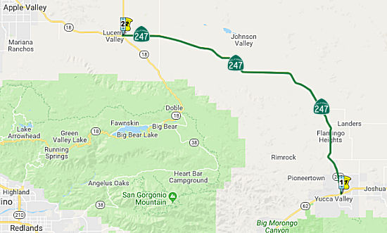 From Route 62 near Yucca Valley to Route 18 near Lucerne Valley.
 Post 1964 Signage History
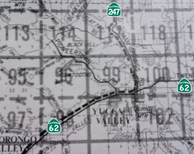 Asdefined
in 1963, this segment was the entirety of Route 247. It was originally
planned to be a freeway between Route 62 and Route 18 ("Old Woman Springs
Freeway").
Asdefined
in 1963, this segment was the entirety of Route 247. It was originally
planned to be a freeway between Route 62 and Route 18 ("Old Woman Springs
Freeway").
 Pre 1964 Signage History
This routing was an extension to LRN 187 that was defined in 1959. It appears to not have been constructed before 1963.
 Status
In May 2010, the CTC approved for future consideration of funding a project in San Bernardino County that will construct 8-foot wide shoulders in each direction on a 7.8 mile portion of Route 247 near the town of Yucca Valley (08-SBd-247, PM 1.8/9.6). In addition to the shoulder widening, shoulder backing will also be installed. The project is fully funded in the 2010 State Highway Operation and Protection Program. Total estimated project cost is $19,504,000 for capital and support. Construction is estimated to begin in Fiscal Year 2012-13. The project will involve construction activities in the habitat of the Pallid San Diego pocket mouse, the Desert tortoise, and the Northern red-diamond rattlesnake. All three species are State listed species of special concern.
In August 2015, the CTC approved for future consideration of funding a project in San Bernardino County that will construct shoulders at various locations and place rumble strips on the existing and proposed shoulders on Route 247 in the community of Landers (08-SBd-247, PM 9.6/20.3). The project is programmed in the 2014 State Highway Operation and Protection Program. The total estimated cost is $29,281,000 for capital and support. Construction is estimated to begin in Fiscal Year 2016-17. The scope, as described for the preferred alternative, is consistent with the project scope programmed by the Commission in the 2014 State Highway Operation and Protection Program.
In December 2018, the CTC received an information report of an allocation
of $1,808,000 for the following project: San Bernardino 08-SBd-247
20.3/76.8 PPNO 08-3006K. Route 247 In and near Barstow, from 0.1 mile
north of Boone Road to 0.7 mile south of Rimrock Road. Outcome/Output:
Construct ground-in shoulder and centerline rumble strips. This safety
project will reduce the number and severity of collisions.
(Source: December 2018 CTC Minutes, Agenda Item 2.5f(3) Item 3)
In June 2021, it was reported that Caltrans was working on two projects
to resurface Route 247 between Lucerne Valley and Barstow. The repairs
will occur on the highway between PM SBD 39 to SBD 42, and PM SBD 46 to
SBD 70. The first section is on the east-to-west part of Route 247 for a
roughly 3-mile stretch of road between Midway Avenue and Clark Street (a
dirt road about half a mile east of Camp Rock Road). The second section of
the project is situated on the part of the highway that runs north to
south and connects the two communities. PM SBD 46 is near Rabbit Springs
Road in Lucerne Valley, while PM SBD 70 is just south of Cape Gloucestor
Avenue, a dirt road fewer than 2 miles north of the Slash X Cafe. The
repairs will be done with a mill-and-overlay approach, which essentially
means using heavy-duty machinery to rip old asphalt from the ground and
replace it with a fresh, pothole-free roadway.
(Source: VV Daily Press, 6/17/2021)
In August 2018, the CTC approved $1,625,000 in SHOPP funding for San
Bernardino 08-SBd-247 39.5/40.0 Route 247 Near Lucerne Valley, from 0.1
mile south to 0.4 mile north of Camp Rock Road. Outcome/Output: Improve
safety by constructing shoulders and installing shoulder and centerline
rumble strips. This project will reduce the number and severity of
collisions.
(Source: August 2018 CTC Agenda Item 2.5f.(3) Item
13)
 Naming
 "Old Woman Springs Road". Here's the story behind the name, from the A Widow's Ride blog: "In 1850’s, a surveyor, Colonel Henry Washington, who was the nephew of our president George Washington was
hired by the government to survey the West. Two years after
California became a state he was hired by the government to lay out the
grid that all land parcels are tied too in Southern California, this grid
system is still being used today. Being the first white man into
this mostly uninhabited area he was responsible for penning the names of
many of the landmarks in the Mojave Desert as he conducted his
survey. As the story goes there was one or possibly a few old Native
American women living at the spring when he passed through conducting his
survey, thus the name Old Woman Springs. At that time they there
were several springs bubbling up out of the ground. Later as the
springs were purchased and sold each owner made improvements which
included creating lakes to store the water, this water could then be used
to raise alfalfa that would feed cattle that would be raised for
beef. The cattle would graze in the summer near Big Bear then in the
winter at Old Woman Springs. At one time, in 1957, there was even a train
that was brought to the Springs, the Cottonwood and Southern Railroad and
there was also a landing strip.
"Old Woman Springs Road". Here's the story behind the name, from the A Widow's Ride blog: "In 1850’s, a surveyor, Colonel Henry Washington, who was the nephew of our president George Washington was
hired by the government to survey the West. Two years after
California became a state he was hired by the government to lay out the
grid that all land parcels are tied too in Southern California, this grid
system is still being used today. Being the first white man into
this mostly uninhabited area he was responsible for penning the names of
many of the landmarks in the Mojave Desert as he conducted his
survey. As the story goes there was one or possibly a few old Native
American women living at the spring when he passed through conducting his
survey, thus the name Old Woman Springs. At that time they there
were several springs bubbling up out of the ground. Later as the
springs were purchased and sold each owner made improvements which
included creating lakes to store the water, this water could then be used
to raise alfalfa that would feed cattle that would be raised for
beef. The cattle would graze in the summer near Big Bear then in the
winter at Old Woman Springs. At one time, in 1957, there was even a train
that was brought to the Springs, the Cottonwood and Southern Railroad and
there was also a landing strip.
(Information on the name: A Widow's Ride blog, Desert Road Trippin'; Image source: Gribblenation)
 The segment between Route 62
and the town limit of Yucca Valley (~ SBD 0.000 to SBD 5.136), in the
County of San Bernardino is named the "Deputy Greg A. Gariepy Memorial
Highway." This segment was named in memory of Deputy Greg A.
Gariepy. Born July 2, 1965, Gariepy was a man of high integrity and
devotion, whose life of dedication and sacrifice began at a young age. In
1983, he joined the Marine Corps, embarking on a 20-year career that
included such assignments as drill instructor, sniper, and antiterrorism
expert, and during which he attained the rank of E7, Gunnery Sergeant, and
was awarded 24 medals, commendations, and ribbons. Upon his retirement
from the Marine Corps on September 30, 2003, he chose to serve his
community by joining the San Bernardino County Sheriff's Department, and
he graduated from the academy with class No. 153 in December 2003. During
his career with the San Bernardino County Sheriff's Department, he worked
at the West Valley Detention Center, the Morongo Basin Station, and,
finally, the Twentynine Palms station. On June 22, 2005, while on patrol
and en route to assist a fellow deputy, he was involved in a fatal traffic
accident in the town of Yucca Valley. Deputy Gariepy is remembered by his
colleagues in the San Bernardino County Sheriff's Department as a
"warrior" who led by example, who was not afraid to volunteer for the most
difficult of duties, and who was a humble leader who understood that true
leadership is characterized by action, not position. Named by Assembly
Concurrent Resolution (ACR) 20, Resolution Chapter 65, on 7/3/2007.
The segment between Route 62
and the town limit of Yucca Valley (~ SBD 0.000 to SBD 5.136), in the
County of San Bernardino is named the "Deputy Greg A. Gariepy Memorial
Highway." This segment was named in memory of Deputy Greg A.
Gariepy. Born July 2, 1965, Gariepy was a man of high integrity and
devotion, whose life of dedication and sacrifice began at a young age. In
1983, he joined the Marine Corps, embarking on a 20-year career that
included such assignments as drill instructor, sniper, and antiterrorism
expert, and during which he attained the rank of E7, Gunnery Sergeant, and
was awarded 24 medals, commendations, and ribbons. Upon his retirement
from the Marine Corps on September 30, 2003, he chose to serve his
community by joining the San Bernardino County Sheriff's Department, and
he graduated from the academy with class No. 153 in December 2003. During
his career with the San Bernardino County Sheriff's Department, he worked
at the West Valley Detention Center, the Morongo Basin Station, and,
finally, the Twentynine Palms station. On June 22, 2005, while on patrol
and en route to assist a fellow deputy, he was involved in a fatal traffic
accident in the town of Yucca Valley. Deputy Gariepy is remembered by his
colleagues in the San Bernardino County Sheriff's Department as a
"warrior" who led by example, who was not afraid to volunteer for the most
difficult of duties, and who was a humble leader who understood that true
leadership is characterized by action, not position. Named by Assembly
Concurrent Resolution (ACR) 20, Resolution Chapter 65, on 7/3/2007.
(Image source: Officer Down Memorial Page)
 The portion of Route 247
in the County of San Bernardino, beginning at Camp Rock Road at SBD 39.598
and continuing to the intersection of Route 247 and Allen Way at SBD
44.366 is named the "Sergeant Brian Walker Memorial Highway".
Sergeant Brian L. Walker was born and raised in San Bernardino
County’s high desert region. He attended Lucerne Valley High School,
where he was an officer in the Future Farmers of America program. Sergeant
Walker served as a military policeman in the United States Army assigned
to the 425th Brigade Special Troops Battalion, 4th Brigade Combat Team
(Airborne), 25th Infantry Division. Six days after arriving for his second
deployment in the Middle East, Sergeant Walker was tragically killed in
Afghanistan on May 13, 2012, when a vehicle under his command was hit with
an improvised explosive device, killing him and the driver of the vehicle,
Private First Class Richard L. McNulty III. Named by Assembly Concurrent
Resolution (ACR) 180, Res. Chapter 162, Statutes of 2016, on September 1,
2016.
The portion of Route 247
in the County of San Bernardino, beginning at Camp Rock Road at SBD 39.598
and continuing to the intersection of Route 247 and Allen Way at SBD
44.366 is named the "Sergeant Brian Walker Memorial Highway".
Sergeant Brian L. Walker was born and raised in San Bernardino
County’s high desert region. He attended Lucerne Valley High School,
where he was an officer in the Future Farmers of America program. Sergeant
Walker served as a military policeman in the United States Army assigned
to the 425th Brigade Special Troops Battalion, 4th Brigade Combat Team
(Airborne), 25th Infantry Division. Six days after arriving for his second
deployment in the Middle East, Sergeant Walker was tragically killed in
Afghanistan on May 13, 2012, when a vehicle under his command was hit with
an improvised explosive device, killing him and the driver of the vehicle,
Private First Class Richard L. McNulty III. Named by Assembly Concurrent
Resolution (ACR) 180, Res. Chapter 162, Statutes of 2016, on September 1,
2016.
(Image source: VV Daily Press)
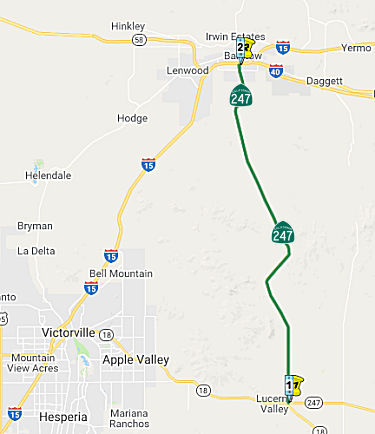 From Route 18 near Lucerne Valley to Route 15 in Barstow.
Post 1964 Signage History▸In 1970, Chapter 1473 split the route and added (b): “(b) Route 18 near Lucerne Valley to Route 15 near Barstow.”
▸In 1994, Chapter 1220 clarified the routing: “(b) Route 18
near Lucerne Valley to Route 15 near in
Barstow.”
Note that the creation of this segment created an oddity in the routing: naming, that the route crosses itself in Lucerne Valley. Logically, the route runs W to Route 18 (Segment 1), along Route 18 to the SE, and then N from Route 18 along Barstow Road (crossing itself at the intersection of Old Woman Springs and Barstow Road).
Pre 1964 Signage HistoryThis routing was not in the state highway system before 1963, although it appears to have been constructed.
Naming"Barstow Road" between I-15 and Route 18. Barstow refers to the city of Barstow, which was named in 1886 by the Santa Fe Railroad for its president, William Barstow Strong.
 Freeway
[SHC 253.1] Entire route. Added to the Freeway and Expressway system in 1959.
 Scenic Route
[SHC 263.1] Entire route.
In November 2021, it was reported that there was progress on the next
step (beyond designation in the state code) to getting the highway signed
as a scenic route. The Homestead Valley Community Council (HVCC) Scenic 247 committee worked with Caltrans guidelines to create the Visual Assessment of the sections of the
highway with the fewest intrusions from modern development, then
researched existing protection plans for wildlife habit in the scenic
corridor. This story is detailed on their website, which includes the original presentation to recruit sponsors, not for funding but for public approval. The scenic designation
is in the works because the state lands commission plans 30,000 acres of
state school lands in the scenic corridor of Route 247 be developed as
Stagecoach Solar, to raise money for the teachers retirement fund, and
this will have a visual impact on the route from substations, overhead
transmission lines, and related connection infrastructure. The
committee description of the route notes that Route 247 "is two lanes
wide, little changed since it was paved in 1958. It travels through high
desert vistas, and these are little changed for hundreds of years. It
takes drivers past old homestead cabins, some abandoned to the elements,
many still occupied, some transformed into dream getaways. It presents a
fascinating array of California geology and biology. Mesas, huge sand
washes, lava flows, cinder cones, mountains in a variety of forms. The
Joshua Tree, signature of the Mojave desert, appears everywhere, sometimes
alone, sometimes in forest stands. Yucca abounds and so does the amazing
creosote bush. As the road curves into the breathtaking panorama of
Johnson Valley, the views are completely uninterrupted. Sandy tracks
wander off into the desert toward old mines, inviting the visitor in a
four-wheel-drive vehicle, with a supply of water, to go to the distant
mountains. The mystery and mystique of these ranges against the desert sky
are unforgettable, whether the sky is clear, hazy, built up with piles of
clouds, trailing rain, or even snowing. In the early morning or late
evening, long blue shadows trail across alluvial fans and knobby hills.
Eagles, hawks and coyotes range far and wide." In December 2021, it was
reported that the San Bernardino County Planning Commission voted Dec. 9
to support designation of Route 247 as a scenic highway.
(Source: High Desert Star, 11/29/2021; High Desert Star, 12/15/2021)
 Other WWW Links
 Statistics
Overall statistics for Route 247:
 Pre-1964 Legislative Route
In 1959, Chapter 1062 defined LRN 247 as “[LRN 4] near Elk Grove to [LRN 246] near Antelope.” This is Route 143, originally planned to run along Elk Grove Florin Road and Watt Avenue.
© 1996-2020 Daniel P. Faigin.
Maintained by: Daniel P. Faigin
<webmaster@cahighways.org>.
 Route 246
 Route 248