
 California Highways:
Click here for a key to the symbols used. An explanation of acronyms may be found at the bottom of the page.
 Routing
 Post 1964 Signage History
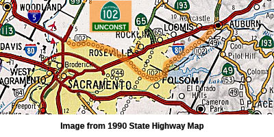
This route remains as defined in 1963.
Around 2000, planning for Route 102 had realigned it from the Auburn-Folsom-Rio Linda-Elkhorn routing of Route 102 (which would've crossed I-80 twice and parallelled Folsom Lake and Elkhorn Boulevard/Greenback Lane) in 1994 to a direct route from Auburn to Elkhorn/Natomas crossing through undeveloped areas in Sacramento and Placer County.
This was a "dotted line on the map" route extending east from near the
I-5/Route 99 interchange between Natomas and the airport, and paralleling
Elkhorn Road and Greenback Way out to the Orangevale area, then turning
north via Granite Bay, terminating at I-80 near Auburn. It was never more
than a proposed corridor concept, and later planning shifted it to a more
northeastern trajectory from its west terminus, skirting Lincoln to the
south and crossing Route 49 north of Auburn before turning east to
intersect I-80 near Applegate, where Route 102 would terminate. It was
explicitly intended to be a traffic reliever for I-80 in the
Sacramento-Auburn corridor; it would have likely also prompted the
decommissioning of the Route 193 segment from Lincoln to Newcastle.
(Source: Sparker @ AAroads, 7/23/2016)
In 2002, the Traversable Highways Report noted that a Feasibility Study
has been completed in 1991 but further corridor studies are needed.
Budgetary constraints have stalled these studies. Placer County is
pursuing Placer Parkway, an access controlled facility to be built to
freeway standards between Route 65 near Roseville and Route 99 near
Lincoln north of Sacramento. It would be a freeway with only a few local
interchanges. The intent is to serve as a reliever route for I-80. This
proposal came out of the routing study for Route 102 which was conducted
in the 1980s and follows much of the recommended alignment that came out
of that study. The project is led by the Placer County Transportation
Planning Agency. The City of Rocklin is nearly finished building an
interchange on Route 65 (Whitney Ranch Parkway) that is intended to serve
as the western terminus of Placer Parkway and Placer County is planning to
build the first piece of the parkway which would run about 1-2 miles west
from this interchange. Placer County has a transportation sales tax on the
November 2016 ballot which, if it passes, could also help pay for the
remainder of the project. There is the possibility that it could be built
as a toll road. The Route 65 Whitney Ranch interchange will be the Eastern
end of the Placer Parkway. It will be an L-9 parclo interchange. There are
no plans to extend Placer Parkway east of Route 65 or west of Route 99.
The western terminus at Route 99 would have flyover connections, and not
be a trumpet interchange. It would tie in between Sankey and Riego Roads.
The proposal is to limit the number of interchanges on the Placer Parkway
and have a wide right of way to minimize growth and sprawl. The project is
being developed locally and it's unclear if the state would adopt it after
completion.
(Source: Joe Rouse at AAroads, 7/30/2016)
The 2013 Traversable Highways Report indicated that the general routing was not determined and there was no traversable highway. Placer County is pursuing the Placer Parkway between Route 99 and Route 65, which would fulfill some, but not all, of the Route 102 need and purpose. Presently in the PA & ED phase, the Placer-Parkway would be an Access-controlled facility. The CTC authorized a Feasibility Study for the Placer Parkway in October 1988. The Feasibility Study was completed by Caltrans in February 1991. In October 1991, the CTC authorized continued corridor studies, but various constraints later stalled study activity.
 Pre 1964 Signage History
This was unsigned proposed LRN 246, defined in 1959.
Route 102 was not defined as part of the initial state signage of routes in 1934. It is unclear what (if any) route was signed as Route 102 between 1934 and 1964.
 Freeway
[SHC 253.1] Entire route; unconstructed. Added to the Freeway and Expressway system in 1959.
 Interstate Submissions
In April 1958, it appears that the designation I-102 was proposed for the route that is now I-210. This was part of the first attempt to assign 3-digit interstates n California. The number was rejected by AASHTO.
 Other WWW Links
 Statistics
Overall statistics for Route 102:
 Pre-1964 Legislative Route
In 1933, Chapter 767 added the route from "Napa-Calistoga Road near Rutherford to Napa-Winters Road via Sage Canyon" to the highway system. In 1935, this was codified as LRN 102 in the highway code with the following definition:
This definition remained unchanged until 1963. This route ran from the Route 29/Route 128 junction (the present-day Route 121/Route 128 junction) near Rutherford to the Route 37/Route 128 junction (the present-day Route 121/Route 128 junction) via Sage Canyon. This is signed as Route 128.
© 1996-2020 Daniel P. Faigin.
Maintained by: Daniel P. Faigin
<webmaster@cahighways.org>.
 From Route
  Route 101
 Route 103