
 California Highways:
Click here for a key to the symbols used. An explanation of acronyms may be found at the bottom of the page.
 Routing
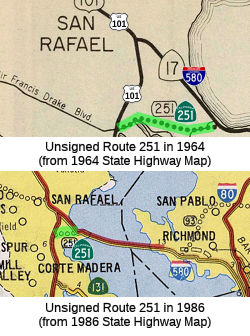 From Route 580 near Point San Quentin to Route 101 near Greenbrae.
 Post 1964 Signage History
As initially defined in 1963, this segment was the entire route, and was defined as “Route 101 near Greenbrae to Route 17 near Point San Quentin.”
In 1984, Chapter 409 reordered this segment and changed "Route 17" to "Route 580".
In 2002, the Traversable Highways report showed this as "to be improved" in 5 years, but this appears to never have happened. The traversable route is Sir Francis Drake Road. There is a 4-lane section for 1.0 mile, and a 40' section for 0.5 mile. The existing underpass has only a 14' clearance. This is used as a cut-off between US 101 and the Richmond-San Rafael bridge.
 Pre 1964 Signage History
This segment corresponds to pre-1963 LRN 251, defined in 1959. This is one of the few whose sign routes equals their pre-1963 legislative routes.
 Status
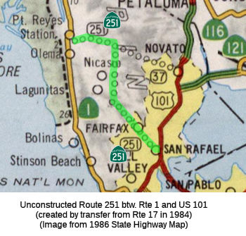
This routing is unconstructed. For the US 101 to I-580 segment, the
traversable route is Sir Francis Drake Blvd. The remainder of the
traversable local routing includes Petaluma Pt. Reyes Road, and Nicasino
Valley Road. These roads are not constructed to state standards. There are
no plans for Caltrans to adopt this routing. The 2013 Traversable Highways
report notes that a county road used as a connection between Route 101
and Richmond-San Rafael Bridge (interstate to interstate).
 From Route 101 near San Rafael to Route 1 near Point Reyes Station.
Post 1964 Signage HistoryIn 1984, Chapter 409 added segment (b) as a result of a transfer from Route 17, giving: “(a) Route 580 near Point San Quentin to Route 101 near Greenbrae. (b) Route 101 near San Rafael to Route 1 near Point Reyes Station.”
 In 1966, results were presented of corridor studies for then Route 17. It
notes that the Marin County plan, as of 1961, showed a route approximately
in the location of the "C" routing. The West Marin Master Plan showed the
state highway through San Rafael, San Anselmo, and Fairfax over White Hill
to the San Geronimo Valley and N to Nicasio. The Kentfield Master Plan
showed a similar route to West Marin. The San Anselmo Master Plan, dated
1959, showed an alignment along the "B" routing. The San Rafael General
Plan of 1966 shows an alignment corresponding to the Central Ridge
corridor. The Central Corridor, or "B" routing, is a continuation of
existing Route 17 (Route 251) from the Richmond-San Rafael Bridge. It
interchanges with US 101 and proceeds W through San Rafael, S of 4th
Street, parallels the Miracle Mile (4th Street and Red Hill Ave) to the
Hub Intersection in San Anselmo. It continues westerly through San
Anselmo, Fairfax, and over the White Hill Grade, to the San Geronimo
Valley, where it swings N to the Nicasio Valley. The "B" route is in an
urban area from the Richmond Bridge to Fairfax, and the "C" route is a
continuation of the "B" route into the rural area from Fairfax to Nicasio.
Another alternative, the Central Ridge, leaves the built-up areas and
climbs to the ridge top behind Red Hill... but it does pass over a portion
of the Sunny Hills Home for Emotionally Disturbed Children and through the
NE portion of the area proposed for a San Anselmo city park. Another
combination of routes investigated combines portions of the Central Ridge
and Lucas Valley corridors. The M-4 line is a cross-over between the Ridge
Route and the Lucas Valley corridor that bypasses the Sleepy Hollow area
as well as the San Geronimo and southerly Nicasio Valley areas.
In 1966, results were presented of corridor studies for then Route 17. It
notes that the Marin County plan, as of 1961, showed a route approximately
in the location of the "C" routing. The West Marin Master Plan showed the
state highway through San Rafael, San Anselmo, and Fairfax over White Hill
to the San Geronimo Valley and N to Nicasio. The Kentfield Master Plan
showed a similar route to West Marin. The San Anselmo Master Plan, dated
1959, showed an alignment along the "B" routing. The San Rafael General
Plan of 1966 shows an alignment corresponding to the Central Ridge
corridor. The Central Corridor, or "B" routing, is a continuation of
existing Route 17 (Route 251) from the Richmond-San Rafael Bridge. It
interchanges with US 101 and proceeds W through San Rafael, S of 4th
Street, parallels the Miracle Mile (4th Street and Red Hill Ave) to the
Hub Intersection in San Anselmo. It continues westerly through San
Anselmo, Fairfax, and over the White Hill Grade, to the San Geronimo
Valley, where it swings N to the Nicasio Valley. The "B" route is in an
urban area from the Richmond Bridge to Fairfax, and the "C" route is a
continuation of the "B" route into the rural area from Fairfax to Nicasio.
Another alternative, the Central Ridge, leaves the built-up areas and
climbs to the ridge top behind Red Hill... but it does pass over a portion
of the Sunny Hills Home for Emotionally Disturbed Children and through the
NE portion of the area proposed for a San Anselmo city park. Another
combination of routes investigated combines portions of the Central Ridge
and Lucas Valley corridors. The M-4 line is a cross-over between the Ridge
Route and the Lucas Valley corridor that bypasses the Sleepy Hollow area
as well as the San Geronimo and southerly Nicasio Valley areas.
(Source: Daily Independent Journal, 11/9/1966, via Joel Windmiller,
2/26/2023)
In January 1966, the editors of the daily Independent Journal declared
that it was “The Time To Pick East-West Marin Route.” The
situation was urgent, they argued: there were still no good routes to
bring tourists to the planned Point Reyes National Seashore, which was
being described as the future “Jones Beach on the Pacific.” In
addition, eastern cities of Marin were suffering from congestion, and
commute times to San Francisco were increasing rapidly. At the request of
the county supervisors, and under pressure from Marin’s
representatives in Sacramento, state engineers presented four routing
options for then Route 17 (now Route 251) to the county board of
supervisors and local city councils in September and October, estimating a
range of costs between $37 and $100 million, and posted maps throughout
the county for public viewing. Highway commission representatives favored
two southerly options, insisting the routes—both of which passed
through several cities—would effectively relieve congestion in the
east as well as bring visitors and new residents to the west. By
mid-November, one of the two favored southerly routes emerged as the most
likely candidate. Both would have displaced a significant number of homes,
but the residential area most dis- rupted by this route was Sleepy Hollow,
an unincorporated community bordering San Anselmo that did not have any
authority to stop construction. This route affected the population that
was least able to defend itself politically, and precedent suggested that
other community members or groups would rally in favor of the option that
did not threaten their immediate interests
(Source: "REVOLT AGAINST SPRAWL: Transportation and the Origins of the Marin County Growth-Control Regime" (paywall), Louise Nelson Dyble, University of Southern California, Journal of Urban History, Vol. 34 No. 1,
November 2007, via Anneliese Agren, 11/15/2023)
Originally, this was to have been the "Point Reyes" Freeway. It was originally part of Route 17 from 1963 to the mid 1980's, when Route 17 was deleted in Marin County as part of the renumber of Route 17 to I-580 and I-880. The Pt. Reyes Freeway was one of many new routes created in the State Freeway and Expressway System, which was approved by the Legislature in 1959. This route has all but been killed by environmental concerns and costs. It would have connected with Route 37.
Pre 1964 Signage HistoryThis was a proposed (routing determined) segment of Route 17. It was part of LRN 69, defined in 1933. This appears to correspond to Francis Drake Blvd. There is an interchange with several flyover ramps at the junction with US 101; this may have been planning for a future freeway Route 251.
StatusThis routing is unconstructed. For the US 101 to I-580 segment, the traversable route is Sir Francis Drake Blvd. The remainder of the traversable local routing includes Petaluma Pt. Reyes Road, and Nicasino Valley Road. These roads are not constructed to state standards. There are no plans for Caltrans to adopt this routing.
 Naming
 Other WWW Links
 Freeway
[SHC 253.1] Entire route; unconstructed. Added to the Freeway and Expressway system in 1959.
 Scenic Route
 Statistics
Overall statistics for Route 251:
 Pre-1964 Legislative Route
In 1959, Chapter 1062 defined LRN 251 as “[LRN 1] near Greenbrae to [LRN 69] near Point San Quentin.” This is one of the few routes that retained the same number post-1963. It is still Route 251.
© 1996-2020 Daniel P. Faigin.
Maintained by: Daniel P. Faigin
<webmaster@cahighways.org>.
 Route 250
 Route 252