
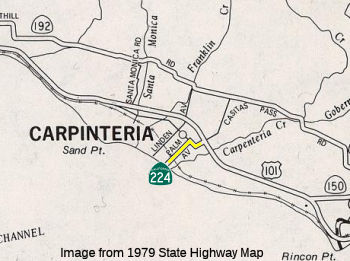
Former State Route 224
Click here for a key to the symbols used. An explanation of acronyms may be found at the bottom of the page.
 Routing
 No current routing.
 Post 1964 Signage History
In 1963, this route was defined as “Route 101 near
Carpinteria
to the Carpinteria Beach State Park.”
In 1992, Chapter 1243 clarified the definition: “Route 101
near in Carpinteria to Carpinteria State Beach
Park”.
In 1996, Chapter 1154 deleted the route. According to the CalTrans
photolog,
this routing had not been relinquished as of 2001.
 Pre 1964 Signage History
The 1964-1996 incarnation of this route was LRN 152, defined in 1933. In
1933, Chapter 767 defined LRN 152 as being from "[LRN 2] near Carpinteria
to
the Carpinteria Beach State Park" to be a state highway. In 1935, this
route
was added to the highway code as LRN 152. The route remained unchanged
until
the 1963 renumbering. It ran from US 101 near Carpinteria to the
Carpinteria
Beach State Park. This was Route 224 between 1964 and 1996.
 Other WWW Links
 Statistics
Overall statistics for former Route 224:
- Total Length (1995): 1 mile
- Average Daily Traffic (1992): 1,100 to 22,800
- Mileage Classification: Rural: 0; Sm. Urban: 0; Urbanized: 1.
- Previous Federal Aid Mileage: FAU: 1 mi.
- Functional Classification: Minor Arterial: 1 mi.
- Counties Traversed: Santa Barbara.
 Pre-1964 Legislative Route
In 1947 (1st Ex Sess), Chapter 11 was defined as “a point on [LRN 2] near
the intersection of Lombard Street and Van Ness Avenue to the San
Francisco-Oakland Bay Bridge approach in San Francisco”.
This was what was Route 480 between 1964 and 1968. Portions of this were
constructed to freeway standards, but were destroyed by the 1989 Loma
Priata
Earthquake.
Acronyms and Explanations:
- "LRN" refers to the Pre-1964 Legislative Route Number.
"US" refers to a US Shield signed route.
"I" refers to an Eisenhower Interstate signed route.
"Route" usually indicates a state shield signed route, but said route may be signed as US or I.
- Previous Federal Aid (pre-1992) categories:
Federal Aid Interstate (FAI); Federal Aid Primary (FAP);
Federal Aid Urban (FAU); and Federal Aid Secondary (FAS).
Current Functional Classifications (used for aid purposes):
Principal Arterial (PA); Minor Arterial (MA);
Collector (Col); Rural Minor Collector/Local Road (RMC/LR). Note that ISTEA repealed the previous Federal-Aid System, effective in 1992, and established the functional classification system for all public roads.
- Other frequently used terms: California Transportation Commission (Commission or CTC), California Department of Transportation (Department or Caltrans), Regional Improvement Program (RIP), Interregional Improvement Program (IIP), State Transportation Improvement Program (STIP), State Highway Operation and Protection Program (SHOPP), Traffic Congestion Relief Program (TCRP), Clean Air and Transportation Improvement Act of 1990 (Proposition 116), High Speed Passenger Train Bond Program (Proposition 1A), Highway Safety, Traffic Reduction, Air Quality, and Port Security Bond Act of 2006 (Proposition 1B), Corridor Mobility Improvement Account (CMIA), State Route 99 Bond Program (RTE or SR 99), Local Bridge Seismic Retrofit Account (LBSRA), Trade Corridors Improvement Fund (TCIF), Highway-Railroad Crossing Safety Account (HRCSA), State-Local Partnership Program (SLPP), Environmental Phase (PA&ED), Design Phase (PS&E), Right of Way (R/W), Fiscal Year (FY), Active Transportation Program (ATP), Trade Corridor Enhancement Program (TCEP), Local Partnership Program (LPP), Local Streets and Roads Program (LSRP), Solutions for Congested Corridors Program (SCCP).
 Route 223
 Route 225
© 1996-2020 Daniel P. Faigin.
Maintained by: Daniel P. Faigin
<webmaster@cahighways.org>.

 California Highways: