
 California Highways:
Click here for a key to the symbols used. An explanation of acronyms may be found at the bottom of the page.
 Routing
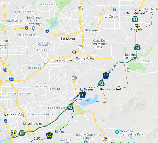 Route 54 is from Route 5 near the Sweetwater River to the
southern city limits of El Cajon.
Route 54 is from Route 5 near the Sweetwater River to the
southern city limits of El Cajon.
The relinquished former portion of Route 54 within the City of El Cajon is not a state highway and is not eligible for adoption [as a state highway].
The City of El Cajon may not impose any special restriction on the operation of buses or commercial motor vehicles on the relinquished former portion of Route 54 if that restriction is in addition to restrictions authorized under other provisions of law.
The unconstructed (and subsequently adoption rescinded portion) between Route 125 and Route 94 is San Diego County Sign Route S17.
 Post 1964 Signage History
▸This route was defined in 1963 as the route from "Route 5 near Sweetwater River to Route 8 near El Cajon." This route was part of the original freeway plans for San Diego.
In 1965, the planned freeway routing of Route 54 between I-5 and
Sweetwater Road was selected by the California Highway Commission during
their Spring Meetings. During 1969, existing Jamacha Road and 2nd
Street in El Cajon were added as active portions of Route 54 from Route 94
to I-8. The freeway corridor of Route 54 was still planned to
eventually replace the active highway.
(Source: Gribblenation Blog (Tom Fearer), "California State Route 54", 3/2023)
Route 54 between I-5 and I-805 was planned to be constructed in
conjunction with the Sweetwater River Channel. Construction of Route 54 along the Sweetwater River Channel became mired in the process of
environmental review through much of the late 1960s and 1970s.
Construction of the Route 54 west of I-805 would ultimately break ground
during May 1984, but was halted due to a 1985 Sierra Club lawsuit which
resulted in an injunction being issued by U.S. District Judge Gordon
Thompson. Construction of Route 54 west of I-805 resumed during
November 1989 after the U.S Fish & Wildlife Service obtained 300 acres
of land in Sweetwater Marsh to create a preserve. On December 11,
1990, the eastbound lanes of Route 54 between I-5 and I-805 opened to
traffic. The westbound lanes opened to traffic in July 1992.
(Source: Gribblenation Blog (Tom Fearer), "California State Route 54", 3/2023)
The existing South Bay Freeway segment of Route 54 east of I-805 to
Woodman Street was converted to full freeway standards between 1993-1998.
(Source: Gribblenation Blog (Tom Fearer), "California State Route 54", 3/2023)
▸In 1999, SB 557, Chapter 99, July 13, 1999 permitted the California Transportation Commission to reliquish the portion of Route 54 located between the S city limits of El Cajon and Route 8. Prior to this, the definition of the route had been "From Route 5 near Sweetwater River to Route 8 near El Cajon."As of the date of relinquishment, the definition of Route 54 was defined by SB 557 to be "From Route 5 near Sweetwater River to Route 8 near the eastern city limits of the city of El Cajon." The segment was not relinquished in the CalTrans Photologs released in 2001.
▸In 2003, AB 1717 (Chapter 525, 9/25/2003) changed the definition to correct the relinquishment, but change "eastern city limits" to "southern city limits".
In October 2017, the CTC approved the recision the freeway route adoption for unconstructed portion of Route 54 between Route 125 and I-8 near 3rd Street (PM 6.7 to 16.9) in San Diego County. There are no local or regional studies contemplating building the unconstructed portion of Route 54 between Route 125 and I-8. The County of San Diego has deleted unconstructed expressway/freeway alignment from their GP2020 General Plan Circulation Element with the support of both Spring Valley and Valle de Oro communities. The Commission approved Resolution NIU 16-02, Notice of Intent to Unadopt, on October 19, 2016. More details in the status section below.
 Pre 1964 Signage History
Before the 1964 renumbering, this route was LRN 280 (defined in 1959). LRN 260 was defined as “LRN 2 (US 101/Future I-5) near Sweetwater River to [LRN 12 (US 80/Future I-8) near El Cajon”. This is present-day Route 54 from I-5 near Sweetwater River to I-8 near El Cajon. It was unsigned.
In late 1961, a 4.2-mile segment of LRN 280 was adopted as a freeway by the California Highway Commission meetings. The adopted freeway segment of LRN 280 began 0.4 miles east of LRN 241 (I-805) and extended west to Sweetwater Road. In 1963, the adopted routing of LRN 280 was extended east to US 80/I-8/LRN 12 in El Cajon. Much of the eastern portion of the adopted routing of LRN 280 followed Jamacha Boulevard and Jamacha Road. In 1964, LRN 280 became Route 54. and the existing highways in the general corridor of Route 54 were assigned as San Diego County Sign Route S17.On 9/27/1963, the initial 4.75 miles of the South Bay Freeway (Route 54)
opened. The South Bay Freeway began as a proposal by San Diego
County for a Federal-Aid Secondary program. The initial corridor of
the South Bay Freeway was selected by San Diego County during 1956.
San Diego County never pursued construction of the South Bay Freeway due
to the increasing valuation of the land parcels in the selected corridor
which led to it being added to the State Highway System as LRN 280 during
1959. Despite being called a freeway, the initial segment of the
South Bay Freeway opened at expressway standards and featured at-grade
intersections. The initial segment of the South Bay Freeway extended
east from the planned corridor of I-805.
(Source: Gribblenation Blog (Tom Fearer), "California State Route 54", 3/2023)
Sign Route 54 was not defined as part of the initial state signage of routes in 1934. It is unclear what (if any) route was signed as Sign Route 54 between 1934 and 1964.
 Status
There also appear to be plans to convert Route 54 between I-5 and Route 125 to full freeway, with an interchange with the Route 125 tollway. Once this is complete, San Diego will have a full freeway circumferential highway (~ SD 0.000 to SD 5.971).
The SAFETEA-LU act, enacted in August 2005 as the reauthorization of TEA-21, provided the following expenditures on or near this route:
In September 2011, the CTC approved $1,619,000 to construct a median barrier on Route 54 from east of Briarwood Road to east of Sweetwater road (~ SD 4.96 to SD 5.919) and on State Route 125, from a half-mile west of Elkelton Place to Elkelton Place. The barrier is to “reduce the number and severity of collisions” in the area.
The portion of Route 54 between 0.6 mi E of Briarwood (the W junction with Route 125) and Jamacha Road (~ SD 5.929 to SD 6.7) has been incorporated into the Route 125 tollway.
Unconstruct Segment Recission (PM SD 6.7 to SD 16.9)
 Unconstructed from Route 125 to Route 94.
There is also an unconstructed freeway routing from Route 94 to Route 8
that would replace the current traversable surface routing. The existing
route (Jamacha Road, County Sign Route S17) does not meet state highway standards.
Unconstructed from Route 125 to Route 94.
There is also an unconstructed freeway routing from Route 94 to Route 8
that would replace the current traversable surface routing. The existing
route (Jamacha Road, County Sign Route S17) does not meet state highway standards.
The 2013 Traversable Highways report notes: Route adopted 8/20/63. Existing route does not meet State highway standards. Route Rescission Report currently under development.
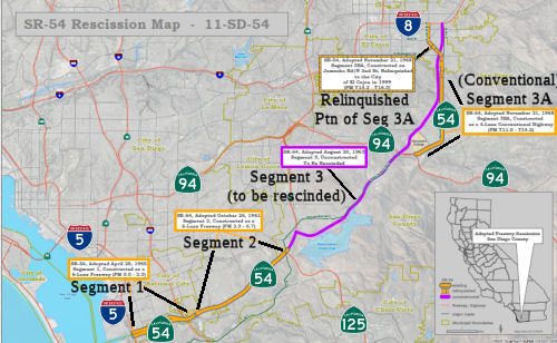 In October 2016, the CTC
approved recission of the freeway adoption between Route 125 and Route 94.
The recission agenda item noted that Route 54 is comprised of two separate
alignments. The first alignment comprise of two constructed, State owned
and operated segments, Segments 1 and 2, and an unconstructed segment,
Segment 3. Segment 1 is the 2.3 mile long section from I-5 to 0.4 mile
east of I-805 and Segment 2 is the 4.4 mile long section from 0.4 mile
east of I-805 to Route 125. Both Segments 1 and 2 are classified as a
six-lane divided freeway. Segment 3 was never constructed and spans from
Route 125 to I-8 near 3rd Street. This 10.2 mile long unconstructed
portion of Route 54 is part of San Diego County Sign Route S17 with the street name of
Jamacha Boulevard.
In October 2016, the CTC
approved recission of the freeway adoption between Route 125 and Route 94.
The recission agenda item noted that Route 54 is comprised of two separate
alignments. The first alignment comprise of two constructed, State owned
and operated segments, Segments 1 and 2, and an unconstructed segment,
Segment 3. Segment 1 is the 2.3 mile long section from I-5 to 0.4 mile
east of I-805 and Segment 2 is the 4.4 mile long section from 0.4 mile
east of I-805 to Route 125. Both Segments 1 and 2 are classified as a
six-lane divided freeway. Segment 3 was never constructed and spans from
Route 125 to I-8 near 3rd Street. This 10.2 mile long unconstructed
portion of Route 54 is part of San Diego County Sign Route S17 with the street name of
Jamacha Boulevard.
The second alignment (Segment 3SA) is a three-mile State owned and operated conventional highway (PM T11.0 to T14.2) from Route 94 to the southern city limits of El Cajon. In 1999, the State relinquished a portion (PM T14.2 to T16.3) of the second alignment, from southern city limits of the City of El Cajon to the intersection of I-8 near 2nd Street. It has been determined that construction of Segment 3 is no longer deemed necessary and has been removed from the Regional Transportation Plan. Furthermore, the Route 54 East Corridor Study, developed by the San Diego Association of Governments (SANDAG) in 2005 states: "the planned improvements in the County of San Diego and the City of El Cajon circulation elements are adequate to handle the study area traffic in the horizon year of 2030. A new expressway or freeway is not warranted.” There is no need to improve adjacent facilities, as they are adequate for handling existing and projected future traffic volumes. The portion of Route 54 to be deleted from the State Highway System is the adopted, unconstructed, freeway/expressway alignment from Route 125 to the intersection with I-8 (Segment 3). Between Route 125 and Route 94, Segment 3 is mostly parallel with the existing Jamacha Boulevard/San Diego County Sign Route S17. Segment 3 north of Route 94 is west of Jamacha Road until Washington Avenue in the City of El Cajon. From Washington Ave to I-8, Segment 3 is parallel to 3rd Avenue east of Jamacha Road. Note that the portion of existing Conventional Highway Route 54 (Jamacha Road) between Route 94 and the southern city limits of the City of El Cajon (Segment 3SA) is not proposed for deletion. However, the Department is planning to relinquish this portion of the route to the County of San Diego.
For years, the regional plan for traffic circulation in the San Diego area envisioned a system of freeway and expressways that connected with each other to form corridors and loops to provide relief to congestion and to establish alternative routes for travel between homes, jobs, shopping and other activity centers. Route 54 was intended as part of a loop bypass around downtown (reflected in its original name, the "Belt Line Freeway"). At time of adoption, Route 54 was planned as a freeway or expressway from I-5 in the South Bay to I-8 in El Cajon, forming an arc and connecting with Route 125 midway. However, the adopted and unconstructed freeway/expressway portion east of Route 125 was never built. As the years have progressed, alternative improvements to the arterial system, particularly in the County of San Diego, have been determined to be adequate for the changing nature of the land uses and projected traffic volumes in that area. In fact, the County of San Diego has widened and improved portions of Jamacha Road to serve the ultimate demand in that area. Based on the findings of SANDAG’s 2005 Route 54 East Corridor Study, affected agencies and jurisdictions concluded that no regional consensus existed for continuing to plan for the unconstructed portion Route 54 as a State highway.
The October 2014 Transportation Concept Report (TCR) recommends that the unconstructed portion of the Route 54, Segment 3, be rescinded and deleted from the State highway system. Furthermore, there is a lack of community support to construct a freeway/expressway on a new alignment by extending existing Route 54 between Route 125 and I-8. Rescission of the freeway adoption for Route 54 will allow the sale of excess lands. The unneeded right of way will make available excess land allowing for further community development, promoting economic growth and will have a positive impact for the community. If the Department retains the excess land, there will be ongoing maintenance costs, including weed abatement, public dumping, and liability concerns.
In October 2017, the CTC approved the recision the freeway route adoption for unconstructed portion of Route 54 between Route 125 and I-8 near 3rd Street (PM 6.7 to 16.9) in San Diego County. There are no local or regional studies contemplating building the unconstructed portion of Route 54 between Route 125 and I-8. The County of San Diego has deleted unconstructed expressway/freeway alignment from their GP2020 General Plan Circulation Element with the support of both Spring Valley and Valle de Oro communities. The Commission approved Resolution NIU 16-02, Notice of Intent to Unadopt, on October 19, 2016. The Department then notified all affected local and regional agencies of the intent to rescind this route. Once the route rescission is approved, the Department’s responsibility is to dispose of the excess land. The portion of existing conventional highway Route 54 along Jamacha Road, between Route 94 and the southern city limits of the City of El Cajon (Segment 3SA), is not proposed for deletion. The County of San Diego has widened and improved portions of Jamacha Road to serve the ultimate traffic demand in that area. The Department plans to relinquish this portion of the route to the County of San Diego in the future. The October 2014 Transportation Concept Report (TCR) recommends that the unconstructed portion of the Route 54, Segment 3, be rescinded and deleted from the State Highway System. Furthermore, there is a lack of community support to construct a freeway/expressway on a new alignment by extending existing Route 54 between Route 125 and I-8. Rescission of the freeway adoption for Route 54 will allow the sale of excess lands. The unneeded right of way will make available excess land allowing for further community development, promoting economic growth and will have a positive impact for the community. If the Department retains the excess land, there will be ongoing costs for maintenance, including weed abatement, public dumping, and liability concerns.
 Naming
The portion of this routing that is constructed to freeway standards is named the "South Bay Freeway". It was named by location. The Caltrans naming log only shows it being named from Route 805 to Route 94. This was originally to be called the "Belt Line" Freeway, and was part of the "Inner Loop" with Route 52 and Route 125.
 The portion of Route 54 from its westernmost point to its
intersection with Route 125, in the County of San Diego, is officially
named the "Filipino-American Highway". This segment was named in
honor of the Filipino-American Community, which has made many
contributions to California and the nation. Among the many past and
present Filipino-American historical figures is Carlos Bulosan, a novelist
and poet best known for the semi-autobiographical "America is in the
Heart," who was active in labor politics along the Pacific coast of the
United States and edited the 1952 yearbook for I.L.W.U. Local 37, a
predominantly Filipino-American cannery union based in Seattle. Other
Filipino-American historical figures include, Philip Veracruz, a labor
leader who helped to found the United Farmworkers Union with Cesar Chavez,
and Major General Edward Soriano, the only Filipino-American to have
attained the rank of general in the U.S. Armed Forces. Major General
Edward Soriano was born in Pangasinan and migrated to the United States
with his family at an early age. In 2001, he was the director of
operations, readiness, and mobilization at the office of America's Deputy
Chief of Staff for Operations and Plans. In the County of San Diego,
Filipino-Americans are the largest Asian Pacific Islander group, making up
4.3 percent of the population of the country, with many living in National
City, Chula Vista, and Southern San Diego. Major Filipino-American groups
in the County of San Diego include the Filipino American Educators
Association of San Diego County, the Council of Philippine American
Organizations of San Diego County, and the Filipino American Chamber of
Commerce of San Diego County. Named by Assembly Concurrent Resolution
(ACR) 157, Resolution Chapter 145, on 9/12/2006.
The portion of Route 54 from its westernmost point to its
intersection with Route 125, in the County of San Diego, is officially
named the "Filipino-American Highway". This segment was named in
honor of the Filipino-American Community, which has made many
contributions to California and the nation. Among the many past and
present Filipino-American historical figures is Carlos Bulosan, a novelist
and poet best known for the semi-autobiographical "America is in the
Heart," who was active in labor politics along the Pacific coast of the
United States and edited the 1952 yearbook for I.L.W.U. Local 37, a
predominantly Filipino-American cannery union based in Seattle. Other
Filipino-American historical figures include, Philip Veracruz, a labor
leader who helped to found the United Farmworkers Union with Cesar Chavez,
and Major General Edward Soriano, the only Filipino-American to have
attained the rank of general in the U.S. Armed Forces. Major General
Edward Soriano was born in Pangasinan and migrated to the United States
with his family at an early age. In 2001, he was the director of
operations, readiness, and mobilization at the office of America's Deputy
Chief of Staff for Operations and Plans. In the County of San Diego,
Filipino-Americans are the largest Asian Pacific Islander group, making up
4.3 percent of the population of the country, with many living in National
City, Chula Vista, and Southern San Diego. Major Filipino-American groups
in the County of San Diego include the Filipino American Educators
Association of San Diego County, the Council of Philippine American
Organizations of San Diego County, and the Filipino American Chamber of
Commerce of San Diego County. Named by Assembly Concurrent Resolution
(ACR) 157, Resolution Chapter 145, on 9/12/2006.
(Image source: BakItWhy)
 Named Structures
 Bridges 57-0845, 57-0844, the Route 54/Route 5 interchange (SD 000.01), is named the "George R.
Volland Memorial Bridge". It was named in memory of George R.
Volland, who served his country with honor and distinction in the United
States Navy in a career that spanned 22 years, achieving the rank of
Master Chief. Sailing from ports in this state, George R. Volland
journeyed to the Pacific, Atlantic, and Indian Oceans, the Mediterranean
Sea, the Suez and Panama Canals, and untold ports of call, to ensure the
security and integrity of the United States and its citizens. During all
his journeys, George R. Volland always looked forward to the day when he
would return to his beloved California and the 32nd Street Naval Station
at San Diego, home of the Pacific Surface Fleet of the United States Navy.
Over his distinguished career, which included service in World War II, and
the wars in Korea and Vietnam, George R. Volland named as his home many of
the port cities of this state, including Imperial Beach, National City,
Chula Vista, San Diego, Long Beach, San Francisco, Richmond, Antioch, and
Stockton. On June 23, 1976, George R. Volland died in the aftermath of a
massive heart attack, sustained in May 1976, while attending to the junior
high school and high school student victims of a terrible bus accident in
Martinez, in which 17 were killed and more than 40 others were injured. It
was named by Assembly Concurrent Resolution 60, Chapter 30 in 1998.
Bridges 57-0845, 57-0844, the Route 54/Route 5 interchange (SD 000.01), is named the "George R.
Volland Memorial Bridge". It was named in memory of George R.
Volland, who served his country with honor and distinction in the United
States Navy in a career that spanned 22 years, achieving the rank of
Master Chief. Sailing from ports in this state, George R. Volland
journeyed to the Pacific, Atlantic, and Indian Oceans, the Mediterranean
Sea, the Suez and Panama Canals, and untold ports of call, to ensure the
security and integrity of the United States and its citizens. During all
his journeys, George R. Volland always looked forward to the day when he
would return to his beloved California and the 32nd Street Naval Station
at San Diego, home of the Pacific Surface Fleet of the United States Navy.
Over his distinguished career, which included service in World War II, and
the wars in Korea and Vietnam, George R. Volland named as his home many of
the port cities of this state, including Imperial Beach, National City,
Chula Vista, San Diego, Long Beach, San Francisco, Richmond, Antioch, and
Stockton. On June 23, 1976, George R. Volland died in the aftermath of a
massive heart attack, sustained in May 1976, while attending to the junior
high school and high school student victims of a terrible bus accident in
Martinez, in which 17 were killed and more than 40 others were injured. It
was named by Assembly Concurrent Resolution 60, Chapter 30 in 1998.
(Image source: AARoads)
 The overpass on South Woodman Street that crosses Route 54 (Bridge 57-1002, SD 004.21), also known as
the Filipino American Highway, in the City of San Diego is named the "Itliong-Vera
Cruz Memorial Bridge". It was named in honor of Larry Itliong and
Philip Vera Cruz. Larry Itliong was a Filipino American labor leader who
founded the Filipino Farm Labor Union (FFLU) in 1956. He was also a member
of the Agricultural Workers Organizing Committee (AWOC). He was born in
1913 in the Pangasinan Province of the Philippines and immigrated to the
United States in 1929. His first involvement in a labor strike was one
year later in 1930. Itliong was a self-taught labor leader and was
instrumental in leading protests in California and Alaska. After he
founded the FFLU, Larry Itliong became the assistant director of the
United Farm Workers Organizing Committee (UFWOC) which eventually became
the United Farm Workers (UFW). Itliong is viewed as “one of the
fathers of the West Coast labor movement”. On Sept. 8, 1965,
Filipino farm workers, known as manongs, organized by Itliong began the
grape strike that set the stage for the boycott that would lead César
Chávez and thousands of farmworker families to create the
nation’s pioneering agricultural labor union, the UFW. Mexican and
Filipino workers had been historically pitted against one another to
suppress wages or break strikes. Yet Itliong approached César
Chávez, then busy organizing the National Farm Workers Association
(NFWA). For the first time, Filipino and Mexican workers became
“brothers,” eventually forming one organization — the
UFWOC — with Itliong as an assistant director, one of several
Filipino leaders on the executive board. Larry Itliong resigned from the
UFWOC in 1971 and dedicated the remainder of his life to improving the
lives of retired Filipino farm workers, and to a wide variety of community
and civic projects, many of which were related to the Filipino American
community. He died in 1977. Philip Vera Cruz was also a Filipino American
labor leader, a farm worker, and a leader and activist for the Asian
American civil rights movement. He was one of the founders of the AWOC,
which later merged with César Chávez’s NFWA and gave birth
to the UFW. Philip Vera Cruz was a long-time vice president of the UFW.
Vera Cruz was born in Ilocos Sur in the Philippines in 1904 and immigrated
to the United States in 1926. Vera Cruz also worked in canneries and
restaurants and attended Gonzaga University in Spokane, Washington, for a
year. He joined the National Farm Labor Union which was affiliated with
the American Federation of Labor and Congress of Industrial Organizations
in the 1950’s. Along with Larry Itliong, Philip Vera Cruz convinced
César Chávez and Dolores Huerta’s predominantly
Mexican/Latino NFWA to join the Grape Strike and Boycott of 1965 demanding
better pay and benefits. One week later César Chávez and Dolores
Huerta joined the strike that eventually brought an end to the unfair
wages and benefits with a 300 mile pilgrimage from Delano to Sacramento.
After Philip Vera Cruz resigned from the UFW in 1977, he remained loyal to
the UFW and the unionizing movement and maintained his dignity as a
Filipino American supporting his community and fighting for worker’s
rights. He affirmed an embodiment of internationalism and believed in
serving the people instead of making profits. He died in 1994. The
contributions of Larry Itliong and Philip Vera Cruz and other Filipino
American farm workers were instrumental in starting the Grape Strike and
Boycott of 1965. Together the Filipino and Mexican farm laborers formed
the United Farm Workers union (UFW), which would not have been as
successful without this coalition of Filipino and Chicano workers coming
together in unity. Named by Assembly Concurrent Resolution No. 156,
Resolution Chapter 145, on September 02, 2014.
The overpass on South Woodman Street that crosses Route 54 (Bridge 57-1002, SD 004.21), also known as
the Filipino American Highway, in the City of San Diego is named the "Itliong-Vera
Cruz Memorial Bridge". It was named in honor of Larry Itliong and
Philip Vera Cruz. Larry Itliong was a Filipino American labor leader who
founded the Filipino Farm Labor Union (FFLU) in 1956. He was also a member
of the Agricultural Workers Organizing Committee (AWOC). He was born in
1913 in the Pangasinan Province of the Philippines and immigrated to the
United States in 1929. His first involvement in a labor strike was one
year later in 1930. Itliong was a self-taught labor leader and was
instrumental in leading protests in California and Alaska. After he
founded the FFLU, Larry Itliong became the assistant director of the
United Farm Workers Organizing Committee (UFWOC) which eventually became
the United Farm Workers (UFW). Itliong is viewed as “one of the
fathers of the West Coast labor movement”. On Sept. 8, 1965,
Filipino farm workers, known as manongs, organized by Itliong began the
grape strike that set the stage for the boycott that would lead César
Chávez and thousands of farmworker families to create the
nation’s pioneering agricultural labor union, the UFW. Mexican and
Filipino workers had been historically pitted against one another to
suppress wages or break strikes. Yet Itliong approached César
Chávez, then busy organizing the National Farm Workers Association
(NFWA). For the first time, Filipino and Mexican workers became
“brothers,” eventually forming one organization — the
UFWOC — with Itliong as an assistant director, one of several
Filipino leaders on the executive board. Larry Itliong resigned from the
UFWOC in 1971 and dedicated the remainder of his life to improving the
lives of retired Filipino farm workers, and to a wide variety of community
and civic projects, many of which were related to the Filipino American
community. He died in 1977. Philip Vera Cruz was also a Filipino American
labor leader, a farm worker, and a leader and activist for the Asian
American civil rights movement. He was one of the founders of the AWOC,
which later merged with César Chávez’s NFWA and gave birth
to the UFW. Philip Vera Cruz was a long-time vice president of the UFW.
Vera Cruz was born in Ilocos Sur in the Philippines in 1904 and immigrated
to the United States in 1926. Vera Cruz also worked in canneries and
restaurants and attended Gonzaga University in Spokane, Washington, for a
year. He joined the National Farm Labor Union which was affiliated with
the American Federation of Labor and Congress of Industrial Organizations
in the 1950’s. Along with Larry Itliong, Philip Vera Cruz convinced
César Chávez and Dolores Huerta’s predominantly
Mexican/Latino NFWA to join the Grape Strike and Boycott of 1965 demanding
better pay and benefits. One week later César Chávez and Dolores
Huerta joined the strike that eventually brought an end to the unfair
wages and benefits with a 300 mile pilgrimage from Delano to Sacramento.
After Philip Vera Cruz resigned from the UFW in 1977, he remained loyal to
the UFW and the unionizing movement and maintained his dignity as a
Filipino American supporting his community and fighting for worker’s
rights. He affirmed an embodiment of internationalism and believed in
serving the people instead of making profits. He died in 1994. The
contributions of Larry Itliong and Philip Vera Cruz and other Filipino
American farm workers were instrumental in starting the Grape Strike and
Boycott of 1965. Together the Filipino and Mexican farm laborers formed
the United Farm Workers union (UFW), which would not have been as
successful without this coalition of Filipino and Chicano workers coming
together in unity. Named by Assembly Concurrent Resolution No. 156,
Resolution Chapter 145, on September 02, 2014.
(Image sources: Facebook, PeoplePill, Chopsticks Alley)
 Business Routes
There is signage for a "Business Route 54" in El Cajon. This is maintained by the city, and at least one point, uses the wrong shield (Interstate instead of State).
 Commuter Lanes
HOV lanes exist from 0.7 mi N of the Woodman Street overcrossing to 0.6 mi E of the Briarwood Road overcrossing (SD 004.91 to SD 005.60). These lanes opened in August 1996, require two or more occupants, and operate weekdays between 6:00am-9:00am WB, and 3:00pm-7:00pm EB.
 Freeway
[SHC 253.1] Entire route. Added to the Freeway and Expressway system in 1959.
 Classified Landcaped Freeway
The following segments are designated as Classified Landscaped Freeway:
| County | Route | Starting PM | Ending PM |
| San Diego | 54 | 0.00 | 5.53 |
| San Diego | 54 | 6.61 | 6.70 |
 Exit Information
 Other WWW Links
 Statistics
Overall statistics for Route 54:
 Pre-1964 Legislative Route
The route that would become LRN 54 was first defined in the 1919 Third Bond Act as the route from near Michigan Bar to Drytown. In 1933, it was extended from [LRN 11] near Perkins to [LRN 54] near Michigan Bar. In 1935, it was codified into the highway code as
"[LRN 11] near Perkins to Drytown passing near Michigan Bar and Huot's Ranch."
In 1961, Chapter 1146 simplified the definition by changing the terminus to "[LRN 65] near Drytown" and eliminating routing language. It was signed as Route 16, and ran between US 50 (LRN 11) and Route 49 (LRN 65).
© 1996-2020 Daniel P. Faigin.
Maintained by: Daniel P. Faigin
<webmaster@cahighways.org>.
 Route 53
 Route 55