
 California Highways:
Click here for a key to the symbols used. An explanation of acronyms may be found at the bottom of the page.
 Routing
 Post 1964 Signage History
This route is as defined in 1963.
 Pre 1964 Signage History
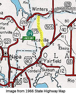
This route (proposed with no routing) was LRN 244, defined in 1959. It was unsigned.
Route 179 was not defined as part of the initial state signage of routes in 1934. It is unclear what (if any) route was signed as Route 179 between 1934 and 1964.
Scott Parker (SParker) noted the following regarding Route 179 on
AAroads:
(Source: Scott Parker (SParker) on AAroads, "Re: Unbuilt CA 179", 2/28/2019)
The Route 179 corridor dates back to LRN days; it was first delineated back in '59 with the first iteration of the California Freeway & Expressway program. [Back then] Lake Berryessa was intended to be much more a recreational destination than it is today; the corridor was simply to provide direct access from I-80 to Route 128 near the dam, and from there around the lake to the various beaches, boat ramps, and the like. Since that time, the lake purpose has been revisited; while there are some boat ramps and shoreline recreational areas, those are primarily near the lakehead some 20 mile NW of the dam area and not really readily accessible from the south end except by twisting county roads -- the easiest access is actually from Middletown in Lake County, NW of the lake itself. Most of the lakeshore remains undeveloped -- and will almost certainly remain such. Without that sort of demand, there's no rationale for improvement of the erstwhile Route 179 corridor.
 Status
The traversable local route is Cherry Glen Road and Pleasant Valley Road. A specific routing has not been determined. There is no recommendation to adopt these roads into the state system.
The 2013 Traversable Highways report notes the closest approximation is Cherry Glen Road, Pleasant Valley Road. There is no recommendation to adopt these roads into the state system.
 Freeway
[SHC 253.1] Entire route; unconstructed. Added to the Freeway and Expressway system in 1959.
 Other WWW Links
 Statistics
Overall statistics for Route 179:
 Pre-1964 Legislative Route
LRN 179 was defined in 1933 as the route from [LRN 60] near Long Beach to Santa Ana. It was codified into the 1935 highway code as:
“from [LRN 60] near Long Beach to Santa Ana”
In 1957, Chapter 36 extended the route to "[LRN 43] near Orange".
This routing (signed as Route 22) ran from LRN 60 (former Route 3; former US 101A; present-day Route 1) near Long Beach to LRN 43 (Route 55) near Orange.
© 1996-2020 Daniel P. Faigin.
Maintained by: Daniel P. Faigin
<webmaster@cahighways.org>.
 From Route
  Route 178
 Route 180