
 California Highways:
Click here for a key to the symbols used. An explanation of acronyms may be found at the bottom of the page.
 Routing
 Post 1964 Signage History
In 1963, Route 27 was defined as the route from “Route 1 near Topanga Beach north of the intersection of Sunset Boulevard and Route 1 to Route 118 at or near Chatsworth.”
In 1965, Chapter 2007 simplified the wording of the origin: "Route 1 near
Topanga Beach north of the intersection of Sunset Boulevard and
Route 1...". In 1981, Chapter 292 simplified the wording of the
terminus: "Route 118 at or near Chatsworth".
Topanga Canyon originally terminated at Santa Susana Pass Road (in fact, it was known as Santa Susana Road N of Devonshire). The extension N of Devonshire St. from just S of the SP Railroad "S" curve to the new freeway was completed in 1966; this extension climbs an 8% grade to an elevation of 1,232'.
In the Chatsworth area, when Sign Route 27 (Topanga Canyon Blvd) originally met LRN 9 (Sign Route 118) at Devonshire Blvd, it changed names to Santa Susanna Pass Road, and continued as Sign Route 118. In 1964 during the great renumbering, Route 27 was extended to end at the Route 118 freeway. The original Santa Susana Pass Road remained, with a right turn onto the older routing just before the incline up the hill started. In the mid-1990s, a new intersection was created for Santa Susana Pass Road and Topanga Canyon Blvd, and the bypassed older segment (original LRN 9) became Old Santa Susana Pass Road.
Topanga Canyon Blvd was rerouted sometime in the 1960s between Plummer and Marilla Street. The original routing was along what is now Topanga Canyon Place, and went first W of the current route, crossed the current route, and then looped E and back to the current route shortly N of Marilla Street. This was to avoid a hill that was later taken down. However, the Plummer to Topanga intersection was constructed in the 1980s or 1990s.
There also appears to be rerouting between Roscoe and Nordhoff, as well as slightly around Oxnard. The original terminus was Devonshire Street, where it met Route 118 and continued N and then W as Santa Susana Ave.
Topanga Expressway
 The 1958 Metropolitan Transportation Engineering Board (MTEB) Master Plan of Freeways and Expressways (PDF) shows that, at the regional level at least, there were plans to reconstruct Topanga Canyon Blvd as an
expressway between Pacific Coast Highway (Route 1) and Newhall
Road/Railroad Avenue (Route 126) in Saugus, going over the mountains N of
Chatsworth. The portion between Route 1 and Route 118 was acknowledged as
state highway, but the portion N of Route 118 was not. Instead, it seemed
to part of a plan that the MTEB planned to submit to the state. The MTEB
remained as a committee within the larger SCAG (Southern California
Association of Governments) until at least the late 1990s, although their
ambitious plans in 1958 never came to fruition.
The 1958 Metropolitan Transportation Engineering Board (MTEB) Master Plan of Freeways and Expressways (PDF) shows that, at the regional level at least, there were plans to reconstruct Topanga Canyon Blvd as an
expressway between Pacific Coast Highway (Route 1) and Newhall
Road/Railroad Avenue (Route 126) in Saugus, going over the mountains N of
Chatsworth. The portion between Route 1 and Route 118 was acknowledged as
state highway, but the portion N of Route 118 was not. Instead, it seemed
to part of a plan that the MTEB planned to submit to the state. The MTEB
remained as a committee within the larger SCAG (Southern California
Association of Governments) until at least the late 1990s, although their
ambitious plans in 1958 never came to fruition.
 Elements of this plan lasted at least through 1971, as the Topanga Expressway was
still shown as planned in the map "Circulation System - Santa Monica
Mountains Area" produced as part of Mulholland Drive Scenic Development
Plan in 1971.
Elements of this plan lasted at least through 1971, as the Topanga Expressway was
still shown as planned in the map "Circulation System - Santa Monica
Mountains Area" produced as part of Mulholland Drive Scenic Development
Plan in 1971.
(Image source: Circulation System - Santa Monica Mountains Area,
Part of Mulholland Drive Scenic Development Plan, Dated: 1971 Source:
CSUN Archives, via email from Will Poundstone, 11/29/2024)
 Pre 1964 Signage History
On July 4,1915, a new thoroughfare called Topanga Highway was opened from
the Ocean to Ventura Boulevard. In 1933 the highway was turned over to the
state which designated it LRN 156, and signed it in 1934 as Sign Route 27.
At that time, it was re-named it Topanga Canyon Blvd.
(Source: Topanga Town Council, 12/21/2024)
In 1934, Sign Route 27 was signed from Jct. Route 3 (US 101A, later Route 1) near Topanga Beach to Jct. Route 118 near Chatsworth. This routing was LRN 156, defined in 1933.
There is an "Old Topanga Canyon Road" that splits off Topanga Canyon Road in the community of Topanga, and continues on a more westerly and winding route, meeting Mullholland Drive near Valley Circle. This does not appear to have ever been a part of Route 27 or LRN 156. It could have been part of the earlier Topanga Highway.
 Status
March 2024 Topanga Closure
In March 2024, it was reported that Topanga Canyon
Boulevard between Pacific Coast Highway and Grand View Drive has been shut
indefinitely in both directions due to an ongoing active landslide,
according to Caltrans. Topanga Canyon Boulevard was first shut down on
March 9, 2024 due to the slide. In April 2024, it was reported that
Caltrans estimates that 9.2 million pounds of earth, or 4,600 tons, gave
way just south of the town of Topanga, sending a wall of dirt, rocks and
debris onto the road. As of mid-April, water continued to seep out from
underneath the dirt, mud and rocks, indicating the mass may move at a
given moment. Because of the instability, crews need to remove material
from the top down since clearing the “toe” – as
it’s known – will only bring down more earth and boulders. The
estimate was that the road would remain closed until Fall 2024. The
landslide is twice as large as another major slide that occurred in the
1940s.
(Source: Malibu Patch, 3/13/2024; Fox 11 News, 4/14/2024)
In May 2024, Gov. Newsom proclaimed a state of
emergency to help fund badly needed repairs of roads battered during this
year’s storms, including scenic Topanga Canyon Boulevard that was
blocked by millions of pounds of debris. The proclamation enables Caltrans
to request funding from the Federal Highway Administration’s
Emergency Relief Program, which could cover up to 100% of the repairs,
according to the governor’s office. Declarations such as this are
useful as California's emergency restoration fund is running low. On the
May 2024 CTC Agenda was Agenda Item 4.17, Request for an additional
$155,000,000, from $845,000,000 to $1,000,000,000, for the Fiscal Year
2023-24 Major Damage (Emergency Restoration) Reservation.
(Source: Los Angeles Times, 5/3/2024; May 2024 CTC Agenda, Agenda Item 4.17)
In May 2024, it was reported that Topanga Canyon would
reopen the first weekend in June 2024, months ahead of officials’
initial estimate. Officials initially projected the closure of
Topanga Canyon Boulevard between Grand View Drive and Route 1 (Pacific
Coast Highway) would last until the fall. It turned out, however, that
there was less dirt, rocks and other material to remove than anticipated
and the landslide wasn’t as deep as originally thought. Caltrans
personnel couldn’t get to the slide area to make a more accurate
estimate until the earth stopped moving. The area remained unsafe for
weeks. Crews ultimately removed about 15,000 cubic yards of material
— much less than the 50,000 to 90,000 they thought they would have
to contend with. The type of slide that occurred is what’s known as
translational, which is “kind of like a tablecloth sliding off the
table.” In other words, just the top layer of soil came down. Once
the slide came to a halt and visual assessments were made, an access road
was built adjacent to the area. This allowed crews to get heavy equipment
to the site and begin digging from the top down. It was still a sizable
landslide, believed to be larger than another major one that occurred
there in the 1940s. According to the governor’s office, crews worked
around the clock seven days a week to stabilize the area and clear the
roadway. The 15,000 cubic yards of material that was removed was
repurposed for Ventura County farmers, the Los Angeles County Department
of Public Works and an art installation in downtown Los Angeles near the
State Historic Park, officials said. To remove materials, crews built an
access road adjacent to the slide to push down materials from the top
using a Spider Excavator and loading the materials into Super-10 trucks
with a long-reach excavator. Now that Caltrans has stabilized the slope
and removed material, geotechnical engineers and geologists will monitor
the site for any movement. Officials recommended a cable-mesh drapery
system to prevent any sloughing of remaining loose materials and planting
native seeds to further stabilize the slope.
(Source: Los Angeles Times, 5/31/2024; Real 92.3 iHeart Radio, 6/3/2024)
In June 2024, the CTC amended the following project
into the SHOPP: 07-LA-27 0.0/5.0. PPNO 07-6267; ProjID 0724000257;
EA 2XN90. Route 27 Near Topanga, from Route 1 to 0.1 mile north of
Circle Trail. Remove debris from roadway, repair slopes, and clean
culverts. Note: Winter storms from February 4 - 6, 2024 brought heavy
rains, causing slides and damaged slopes. This project will remove
debris and mud from the roadway, repair slopes, reconstruct damaged
guardrail and fencing, and clean culverts. Allocation ($ ×
$1000): PA&ED $0; PS&E $0; R/W Sup $100; Con Sup $735; R/W Cap
$100; Const Cap: $2,815; TOTAL $3,750.
(Source: June 2024 CTC Minutes, Agenda Item 2.1a.(1a) #34)
In June 2024, the CTC approved the following Emergency
G-11 Allocation: $3,550,000. 07-LA-27 0.0/5.0. PPNO 07-6267; ProjID
0724000257; EA 2XN90. Route 27 Near Topanga, from Route 1 to 0.1 mile
north of Circle Trail. Winter storms from February 4 - 6, 2024 brought
heavy rains, causing slides and damaged slopes. This project will
remove debris and mud from the roadway, repair slopes, reconstruct damaged
guardrail and fencing, and clean culverts. Allocation: CON ENG
$735,000 CONST $2,815,000.
(Source: June 2024 CTC Agenda, Agenda Item 2.5f.(1) #19)
In August 2024, the CTC approved the following
Emergency G-11 Allocation: $16,745,000. 07-LA-27 0.0/5.0. PPNO 07-6267;
ProjID 0724000257; EA 2XN90. Route 27 Near Topanga, from Route 1 to 0.1
mile north of Circle Trail. Winter storms from February 4 - 6, 2024
brought heavy rains, causing slides and damaged slopes. This project
will remove debris and mud from the roadway, repair slopes, reconstruct
damaged guardrail and fencing, and clean culverts. This supplemental
is needed because drone surveys showed three additional scarps within the
slide extent along with seepage, which is likely to impact the slope's
stability. Additional loose debris between 5 and 10 feet deep will
be removed and the slopes will be benched. Additional drains will be
installed to better control drainage at the slide location. Allocation:
CON ENG $265,000; CONST $16,480,000.
(Source: August 2024 CTC Agenda, Agenda Item 2.5f.(1) #16)
In May 2026, the CTC was informed about the following
emergency G-11 allocation under delegated authority: $2,750,000. 07-LA-27
2.5. PPNO 07-6304; ProjID 0726000211; EA 3XA30. Route 27 Near city of Los
Angeles, at 1.1 miles south of Grand View Drive. In January 2025,
the Palisades fire caused significant damage to Route 27 within Topanga
Canyon. Following the fire, heavy rainfall events resulted in slope
failures, erosion, debris flows, and clogging of drainage systems.
Emergency Director's Order 07-2XR30 was approved to address the emergency
damage. However, the work to install new 84 in. and 72 in diameter
culverts as part of the original scope was unsuccessful due to the
contractor's inability to get through the existing bedrock. This
project will bring in a new contractor to install the drainage culverts
and remove that scope from the original DO under a new supplemental.
Breakdown: CON ENG $250,000; CONST $2,500,000.
(Source: May 2026 CTC Agenda, Agenda Item 2.5f.(1) #37)
In May 2026, the CTC amended the following project into
the 2026 SHOPP: 07-LA-27 2.5. PPNO 07-6304; ProjID 0726000211; EA 3XA30.
Route 27 Near city of Los Angeles, at 1.1 miles south of Grand View Drive.
Install drainage culverts. Note: In January 2025, the Palisades fire
caused significant damage to Route 27 within Topanga Canyon. Following the
fire, heavy rainfall events resulted in slope failures, erosion, debris
flows, and clogging of drainage systems. Emergency Director's Order
07-2XR30 was approved to address the emergency damage. However, the work
to install new culverts as part of the original scope was unsuccessful due
to the contractor's inability to get through the existing bedrock. This
project will bring in a new contractor to install the drainage culverts
and remove that scope from the original DO under a new supplemental.
Allocation ($ × $1000): PA&ED $0; PS&E $0; R/W Sup $0; Con
Sup $250; R/W Cap $0; Const Cap $2,500; TOTAL $2,750.
(Source: May 2026 CTC Agenda, Agenda Item 2.1a.(1a) #38)
In January 2025, the CTC amended the following project into the 2024
SHOPP: 07-LA-1 38.8/40.4. PPNO 07-6290; ProjID 0724000292; EA 2XP70. Route 27 in and near the City of Los Angeles (Pacific Palisades), from 0.1 mile
north of Bel Air Bay Club to 0.4 mile south of Route 27. Remove
existing curb and pave the southbound shoulder, realign pavement
delineation around the slide area, and adjust the loop detectors and
signal heads. Note: The Tramonto Slide is located in the hills above
Pacific Coast Highway in LA and has been moving intermittently from 1936
to present. The heavy rains of February and March 2024 saturated the
slopes that resulted in new movement. The slide encroached into the
northbound #2 lane that has resulted in significant delays. The
permanent solution needs to start at the top of the slide and is City of
LA's responsibility. This project will provide an interim measure. This
project will remove the existing curb and pave the southbound shoulder,
realign the pavement delineation around the slide area, and adjust the
loop detectors and signal heads. Abatement will be sought from the City of
LA. Allocation ($ × $1000) PA&ED $0; PS&E $400; R/W Sup $100;
Con Sup $250; R/W Cap $100; Const Cap $2,500; TOTAL $3,350.
(Source: January 2025 CTC Agenda, Agenda Item 2.1a.(1a) #15)
In August 2016, the CTC approved $31,477,000 for Los Angeles 07-LA-118 R0.0/R14.4 Route 118 in the city and county of Los Angeles, from Ventura County line to Route 210; also on Route 27 (Topanga Canyon Boulevard) from Devonshire Street to Route 118. Outcome/Output: Rehabilitate 65.0 lane miles of roadway to extend pavement surface life and improve ride quality. Replace approach slabs and upgrade curb ramps to meet current ADA standards.
 Scenic Route
[SHC 263.3] From Route 1 to Mulholland Drive.
Eligible for Scenic Highway status per [SHC 263.2]. The following portions have been officially designated as Scenic Highway and are signed:
In April 2013, it was reported that the Los Angeles County Board of Supervisors has asked the state to designate the portion from Route 1 to the Ventura County line as a state scenic highway (essentially, the entire route).
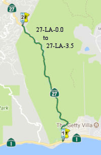 In
June 2017, it was reported that Topanga Canyon Blvd had received a state
scenic highway designation: "Topanga Canyon State Scenic Highway, a 2.5
mile (although another article says 3.5 mi) segment of Route 27, runs
through the county and city of Los Angeles in the Santa Monica Mountains
National Recreation Area near the Pacific coast." The LA Times clarified
that the designation is from Mile 1 to Mile 3.5 (near Old Topanga Blvd),
putting it within the SHC 263.3 designation. The new scenic highway runs
parallel to Topanga Creek, with views of massive rock formations, valleys,
mountains, and a diversity of plants and animals. California’s
scenic state highway program was implemented in 1963 in order to
“add to the pleasure of state residents,” and “encourage
the growth of recreation and tourist industries.” Designated scenic
highways, along with adjacent scenic corridors, require special
conservation treatment. Scenic corridors consist of land that can be seen
from the scenic highway and is next to the highway, even if it is outside
the highway right-of-way. The legislation lets the state assign
responsibility for the regulation of land use and development along scenic
highways to the appropriate state, local and county agencies. “The
city or county must also adopt ordinances, zoning and/or planning policies
to preserve the scenic quality of the corridor or document such
regulations that already exist in various portions of local codes,”
Caltrans specifies. According to Westways magazine, this was the first LA
County road to receive the state scenic highway designation in 45 years.
It was reported as the culmination of a five-year effort by Topanga
Chamber of Commerce members Joseph Rosendo and Roger Pugliese, along with
the Topanga Association for a Scenic Community working with county and
city officials to develop a scenic corridor protection program. The new
Topanga Canyon State Scenic Highway travels through a portion of Topanga
State Park, which features 36 miles of trails through open grassland and
live oaks, and spectacular views of the Pacific Ocean,” it said.
“The park is one of the world’s largest wildlands within the
boundaries of a major city.”
In
June 2017, it was reported that Topanga Canyon Blvd had received a state
scenic highway designation: "Topanga Canyon State Scenic Highway, a 2.5
mile (although another article says 3.5 mi) segment of Route 27, runs
through the county and city of Los Angeles in the Santa Monica Mountains
National Recreation Area near the Pacific coast." The LA Times clarified
that the designation is from Mile 1 to Mile 3.5 (near Old Topanga Blvd),
putting it within the SHC 263.3 designation. The new scenic highway runs
parallel to Topanga Creek, with views of massive rock formations, valleys,
mountains, and a diversity of plants and animals. California’s
scenic state highway program was implemented in 1963 in order to
“add to the pleasure of state residents,” and “encourage
the growth of recreation and tourist industries.” Designated scenic
highways, along with adjacent scenic corridors, require special
conservation treatment. Scenic corridors consist of land that can be seen
from the scenic highway and is next to the highway, even if it is outside
the highway right-of-way. The legislation lets the state assign
responsibility for the regulation of land use and development along scenic
highways to the appropriate state, local and county agencies. “The
city or county must also adopt ordinances, zoning and/or planning policies
to preserve the scenic quality of the corridor or document such
regulations that already exist in various portions of local codes,”
Caltrans specifies. According to Westways magazine, this was the first LA
County road to receive the state scenic highway designation in 45 years.
It was reported as the culmination of a five-year effort by Topanga
Chamber of Commerce members Joseph Rosendo and Roger Pugliese, along with
the Topanga Association for a Scenic Community working with county and
city officials to develop a scenic corridor protection program. The new
Topanga Canyon State Scenic Highway travels through a portion of Topanga
State Park, which features 36 miles of trails through open grassland and
live oaks, and spectacular views of the Pacific Ocean,” it said.
“The park is one of the world’s largest wildlands within the
boundaries of a major city.”
(Source: OneTopanga, 6/17/2017; LATimes,
June 2017; Caltrans; Malibu Times, 10/20/2017)
 Naming
This route is Topanga Canyon Blvd.. Topanga is an Indian name referring to "above place" or even sky or heaven. It may refer to Indian village site located above Topanga Creek.
 Other WWW Links
 Statistics
Overall statistics for Route 27:
 Pre-1964 Legislative Route
The route that was to become LRN 27 was first defined in the 1916 Second Bond Issue as part of the "extension of the San Bernardino county state highway lateral to the Arizona State Line near the town of Yuma, Arizona, via the cities of Brawley and El Centro in Imperial County by the most direct and practical route...". LRN 26 took the portion from the San Bernardino County lateral (LRN 9) down through Brawley and El Centro. LRN 27 then continued E-ly from El Centro to Yuma Arizona. (LRN 26 continued S to Calexico as part of LRN 26's 1931 extension)
In 1935, LRN 27 was codified into the highway code as running from El Centro to Yuma, and was all primary state highway. The definition remained unchanged until 1963 and the great renumbering. This route was signed as US 80, and is present-day I-8.

 LRN 27, as US 80, was part of the "Old Spanish Trail".
This trail essentially followed the alignment of historic Spanish Colonial
trails across Florida, Louisiana and Texas, and became the precursor to
the present-day east-west route across the southern tier of the US. The
early highway, which later became US 80 in California (now I-8), generally
followed the Spanish Jornada de la Muerte across the state and terminated
in downtown San Diego along Park Boulevard/12 Street, where it intersected
with old US 101.
LRN 27, as US 80, was part of the "Old Spanish Trail".
This trail essentially followed the alignment of historic Spanish Colonial
trails across Florida, Louisiana and Texas, and became the precursor to
the present-day east-west route across the southern tier of the US. The
early highway, which later became US 80 in California (now I-8), generally
followed the Spanish Jornada de la Muerte across the state and terminated
in downtown San Diego along Park Boulevard/12 Street, where it intersected
with old US 101.


 LRN 27, as US 80, appears to have
been part of the "Bankhead Highway", the "Dixie Overland Highway"
and the "Lee Highway". Many of these were attempts to commemorate
the "Lost Cause" or "Southern Cause" narrative of the Civil War. Along US 80, monuments were located near the Arizona Border and at the terminus of
US 80 at Horton Plaza. This is discussed in more detail on the Trails and Roads page.
LRN 27, as US 80, appears to have
been part of the "Bankhead Highway", the "Dixie Overland Highway"
and the "Lee Highway". Many of these were attempts to commemorate
the "Lost Cause" or "Southern Cause" narrative of the Civil War. Along US 80, monuments were located near the Arizona Border and at the terminus of
US 80 at Horton Plaza. This is discussed in more detail on the Trails and Roads page.
 LRN 27, as US 80, was part of the Southern
National Highway.
LRN 27, as US 80, was part of the Southern
National Highway.
 LRN 27, as US 80, appears to have been part of the "Lone
Star Trail".
LRN 27, as US 80, appears to have been part of the "Lone
Star Trail".
© 1996-2024 Daniel P. Faigin.
Maintained by: Daniel P. Faigin
<webmaster@cahighways.org>.
 From Route
  Route 26
 Route 28