
 California Highways:
Click here for a key to the symbols used. An explanation of acronyms may be found at the bottom of the page.
 Routing
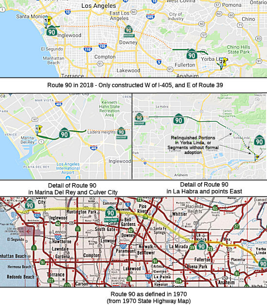 From Route 1
northwest of the Los Angeles International Airport to Route 91 in Santa
Ana Canyon passing near La Habra, except for the portion within the city
limits of Yorba Linda.
From Route 1
northwest of the Los Angeles International Airport to Route 91 in Santa
Ana Canyon passing near La Habra, except for the portion within the city
limits of Yorba Linda.
The relinquished former portion of Route 90 within the City of Yorba Linda is not a state highway and is not eligible for adoption [as a state highway]. The City of Yorba Linda shall ensure the continuity of traffic flow on the relinquished former portion of Route 90, including any traffic signal progression, as well as maintaining signs directing motorists to the continuation of Route 90.
 Post 1964 Signage History
▸In 1963, Route 90 was defined as "Route 1 northwest of the Los Angeles International Airport to Route 605.", and consisted solely of the former LRN 221.
▸In 1965, Chapter 1330 transferred the portion from Route 605 to the junction of Routes 39 and the then Route 42 near La Habra (former LRN 176) were transferred from Route 42 (and thus, Route 90 gained the Yorba Linda freeway). This made the definition for Route 90: "Route 90 is from Route 1 northwest of the Los Angeles International Airport to the junction of Routes 39 and 42 near La Habra." Route 42 was redefined to be (1) from Route 1 west of Inglewood to Route 605 and (2) Route 39 near La Habra to Route 91 in Santa Ana Canyon. Chapter 1372 also amended the route that year, but appeared to make no other changes. Astute observers will note that this left Route 90 and Route 42 roughly parallel.
Construction on the route began in 1966 between Centinela Ave and I-405. The remainder of the route to the W, between Centinela and Route 1 was pending completion of the Pacific Coast Freeway. Eventually, that freeway was abandoned and the western segment was constructed as a limited-access expressway. The eastern portion (Slauson Freeway) still had no route determination, and has not been constructed to date. As a personal footnote here: I remember distinctly driving with my brother on Route 90, right after it opened, sometime in 1968 or 1969.
 In 1966, the Division of Highways presented the proposed route for the Slauson Freeway portion of
the route. It ran from 1,000' E of Hannum Ave (near today's Fox Hills) to
LaBrea. The 1.8 mi route parallels the N side of Slauson Ave from LaBrea,
crosses Slauson at Shenandoah, and parallels the S side of Slauson to
Hannum. There was significant opposition from the Ladera Heights property
owners who felt the freeway was unnecessary. Culver City was originally
against the route, but then wanted speedy adoption to resolve the issue of
development in the Fox Hills area. The ultimate plans were to extend the
freeway to I-605 (a plan that eventually moved to Route 42 and thence to
I-605).
In 1966, the Division of Highways presented the proposed route for the Slauson Freeway portion of
the route. It ran from 1,000' E of Hannum Ave (near today's Fox Hills) to
LaBrea. The 1.8 mi route parallels the N side of Slauson Ave from LaBrea,
crosses Slauson at Shenandoah, and parallels the S side of Slauson to
Hannum. There was significant opposition from the Ladera Heights property
owners who felt the freeway was unnecessary. Culver City was originally
against the route, but then wanted speedy adoption to resolve the issue of
development in the Fox Hills area. The ultimate plans were to extend the
freeway to I-605 (a plan that eventually moved to Route 42 and thence to
I-605).
(Source: Los Angeles Times, 1966, via Joel Windmiller, 2/19/2023)
Other factors leading to the death of the Route 90 Freeway’s
extended planned route was the result of local opposition, national crisis
and waning interest. The initial plan got push-back from business groups
in the 1950s and 1960s. Opposition grew to such a fervor in the early
’60s that some businessmen met with a state assemblyman with whom
they allegedly discussed a $10,000 bribe for the lawmaker to introduce
legislation to reroute the freeway. Assemblyman Lester A. McMillan was
secretly recorded saying that, for the fee, he’d introduce the
legislation. He was indicted in April 1965 on a charge of seeking a bribe.
McMillan’s attorney argued in court that despite the recording, the
legislator didn’t intend to introduce the bill because the
Legislature was in recess, and that the fee was instead for
McMillan’s expenses to work with the group, according to The
Times’ coverage of the trial. He was acquitted later that year,
after the judge ruled there was reasonable doubt whether the $10,000
discussed was indeed a bribe. By the late ’60s, support for the
Marina Freeway and others had dwindled, and construction plans were
practically dead by the ’70s because of inflation and gas shortages.
(Source: Los Angeles Times, 9/23/2023)
▸In April 2002, AB 885 (Chapter 27, 4/23/2002) permitted the relinquishment of that portion of Route 90 in the city of Yorba Linda. Upon relinquishment, the relinquished portion (a) ceases to be a state highway; and (b) may not be considered for future adoption as a state highway. The City of Yorba Linda is required to ensure the continuity of traffic flow on the relinquished portion of Route 90 (including any traffic signal progressions), and must maintain signs directing motorists to the continuation of Route 90. This reliniquishment was done to permit the City of Yorba Linda to quickly assume and complete various construction and maintenance projects on the applicable portion of Route 90 that were underway in 2002 or in the planning and development stages.
▸In 2003, AB 1717 (Chapter 525, 9/25/2003) changed the legislative definition to reflect the relinquishment.
 Pre 1964 Signage History
This route was unsigned in 1963. It did, however, have a legislative definition:
 Sign Route 90 was not defined as part of the initial state
signage of routes in 1934. It is unclear what (if any) route was signed as
Route 90 between 1934 and 1964.
Sign Route 90 was not defined as part of the initial state
signage of routes in 1934. It is unclear what (if any) route was signed as
Route 90 between 1934 and 1964.
The route had its origins in the 1933 definition of LRN 176 as "Buena
Park-Azuza Road near La Habra to LRN 43 in Santa Ana Canyon via Brea." The
first routing was aligned between LRN 62 in La Habra eastward to LRN 43
via Cedar Street (late renamed Imperial Highway). 1935 maps show LRN 176
originating at Route 39/LRN 62 in La Habra. LRN 176 followed Cedar
Street (Imperial Highway) to Loftus. It then followed an interim
alignment via Carolina Street (Kramer Boulevard), Golden Avenue, Rose
Drive, Citrus Avenue (Bastanchury Road) and Plumosa Avenue to Yorba
Linda. From Yorba Linda, LRN 176 followed Imperial Highway, Yorba
Linda Boulevard, Ohio Street, Mountain View Avenue and Kellogg Drive to
Route 14/LRN 175 at Placentia-Yorba Linda Boulevard. It did not yet
connect to Route 18/LRN 43 (today's Route 91). In 1936, a new alignment of
LRN 176 between Cedar Street to Luitweiler Avenue was started as a Federal
Emergency Relief Project.
(Source: Gribblenation Blog (Tom Fearer), "California State Route 90", June 2022)
It is unclear exactly when the Imperial Highway name came to this segment, but the basic
Imperial Highway route was determined in 1931, and the section in Yorba
Linda was completed in 1937. In announcing the completion of the work on
7/31/1937, the August 1937 California Highways & Public Works
indicated that Imperial Highway was to have an eventual planned western
terminus in El Segundo. Imperial Highway had a much longer
definition, but the LRN 176 portion runs along Imperial Highway (from
Firestone and Imperial, the Route 42/Route 90 junction, although postmiles
for Route 90 in the postmile tool do not begin until Route 39). The name
"Imperial" refers to the Imperial Valley, which took its name from the
Imperial Land Co., a subsidiary of the California Development Company
charged with reclaiming the water-starved but arable land east of San
Diego for agricultural purposes in the early 1900s. The company began
building canals in 1900, diverting water from the Colorado River for
irrigation, and forming the Salton Sea in the process. The Los Angeles
area wanted to patch together a superhighway that would stretch from the
Pacific all the way to Brawley in the Imperial Valley, a distance of 215
miles; the route was later extended a few miles farther south to El
Centro. The most route roughly followed the old Butterfield Stage overland
route, established in 1858: across the desert (Route 78) and along
today’s Route 79 to Temecula, where it headed on to Corona via Lake
Elsinore and Temescal Canyon (Route 71, later I-15). There the road turned
left down the Santa Ana Canyon on its way to Yorba Linda (present-day
Route 91) and La Habra (present-day Route 90), then across Los Angeles
County to meet the sea at El Segundo (as Imperial Highway, although it is
paralleled by I-105). The extension to Brawley was along Route 86 The
early Imperial Highway plans involved connecting a patchwork assortment of
roads of varying length and quality. In 1912, a group of Los Angeles
boosters informally known as the Committee of One Hundred, working with
Los Angeles, San Bernardino, Orange, Riverside and Imperial counties,
settled on a route along the edge of the inland Salton Sea that completely
bypassed San Diego County, from which Imperial County had been split off
in 1907. The Los Angeles section of road would be mostly a straight shot
from LAX to Anaheim, where the proposed road would dip south diagonally
before eventually reaching the Imperial Valley. By the 1920s, the efficacy
of the Imperial Highway concept had become apparent, and a new and more
forceful private group, the Imperial Highway Association, was formed in
1929 to encourage the regions involved to mount a fully cooperative
effort, including working closely with San Diego County, to get the job
done. The association adopted an official route for a more streamlined,
uniform highway in 1931 that ran slightly west of the earlier Salton Sea
route. The improved roadway, now referred to informally as “the
Cannon Ball Road,” would eliminate tight right angle turns that
slowed trucks, smooth and widen the various roadways involved, and have
new bridges where necessary. A major section in Yorba Linda was completed
in 1937. Two-lane portions of the highway through Inglewood had to be
expanded to four. A bridge over the Los Angeles River, completed in
1951, eliminated a crucial bottleneck; it replaced an old one that
collapsed in 1948. The final section of the Imperial Highway as envisioned
by the association was completed, and it was dedicated a scenic highway in
a ceremony on the Imperial-San Diego county border in December 1961. Of
its 220 total miles, 77 were county roads, with the rest being state
highways. The cost to complete the project was estimated at $16 million
(about $138 million in 2020 dollars). In 1965, Caltrans planned a new
freeway along the path of Imperial Highway, from LAX to Norwalk. It opened
in 1993 as I-105, though Imperial Highway itself remained in place, if
somewhat less crucial than it once was. Through Orange County, Imperial
Highway was Route 90. Major chunks of the roadway through Riverside and
San Diego counties were subsumed by newer freeways and highways over the
years. The 41-mile Los Angeles stretch, which passes through El Segundo,
Hawthorne, Inglewood, South Los Angeles, Lynwood, South Gate, Downey,
Norwalk, Santa Fe Springs and La Mirada, retains the original Imperial
Highway name, as does a section of Route 86 in El Centro (also known as
Imperial Avenue).
(Source: Daily Breeze, “South Bay History: Imperial Highway once figured as part of a superhighway plan”, 3/29/2021; Orange County History “The Imperial Highway”, 2011)
By 1940, the extension of LRN 176 from Yorba Linda to CA 18/LRN 43 was
appearing on maps.
(Source: Gribblenation Blog (Tom Fearer), "California State Route 90", June 2022)
In 1947, LRN 221 was defined as "A point on LRN 60 (US Route 101A) near
Los Angeles Airport to a point on LRN 165 (US 6/Route 11) between Santa
Barbara and Slauson Avenues.", which was changed in 1953 to "Los Angeles
International Airport to a point on LRN 165 the Harbor Freeway, between
Santa Barbara Avenue and Florence Avenue."
(Source: Gribblenation Blog (Tom Fearer), "California State Route 90", June 2022)
In 1956, it was announced that Route 14/LRN 175 (future Route 91) had
been shifted to the first unit of the Houston Expressway between from
Cypress Avenue to Santa Ana Canyon Road. The realignment of Route 14/LRN 175 onto the Houston Expressway extended LRN 176 to finally reach
US 91/Pre-1964 Route 18/LRN 43. In 1959, a freeway corridor for LRN 176
was adopted that would connect Yorba Linda Boulevard to the Newport
Freeway. In 1960, this was called the "Imperial Freeway", and later
the "Imperial-Yorba Linda Freeway". The initial 2.3 miles of the Yorba
Linda Freeway to US 91 opened on February 8th, 1963.
(Source: Gribblenation Blog (Tom Fearer), "California State Route 90", June 2022)
In 1960, it was reported in CHPW that a section 3.9 miles long in the Culver City-West Los Angeles area was adopted on December 16, 1959 as a freeway by the California Highway Commission. The estimate of cost for ultimate development to eight lanes is $30,800,000 for right-of-way acquisition and construction. The Marina Freeway will provide traffic service for the motorists using recreational facilities in the Santa Monica Bay area, and it could eventually serve as a part of the East-West Slauson Freeway that was included in Senate Bill 480. Route 90 was planned as 22.2 miles consisting of both the Mariana Freeway and Slauson Freeway corridors. The corridor of Route 90 planned to connect Route 1/Pacific Coast Highway at Lincoln Boulevard east to I-605/San Gabriel River Freeway.
In 1963, it was noted that the easterly continuation of the Marina Freeway was under study, and would be called the Slauson Freeway E of I-405.
 Status
 The portion from Inglewood to where Route 90 meets Route 39 is
unsigned; small sections are freeway; orginally planned as freeway from
Route 1 to Route 605 as the Marina-Slauson Freeway, with the
remainder of the route (along Route 42) to have been the Yorba Linda
Freeway. The traversable local routing is Slauson Avenue, which does not
have adequate construction. The route concept report recommends deletion
of Route 90 from the state highway system from unconstructed Route 258 to
the Orange County line.
The portion from Inglewood to where Route 90 meets Route 39 is
unsigned; small sections are freeway; orginally planned as freeway from
Route 1 to Route 605 as the Marina-Slauson Freeway, with the
remainder of the route (along Route 42) to have been the Yorba Linda
Freeway. The traversable local routing is Slauson Avenue, which does not
have adequate construction. The route concept report recommends deletion
of Route 90 from the state highway system from unconstructed Route 258 to
the Orange County line.
According to the 2013 Traversable Highways report:
There is a plan, on the western end, to extend the Marina Freeway west to Mindanao by building a full interchange and grade-separation at Culver.
Marina Central Park
 In August 2023, it was reported that transportation advocacy organization
Streets For All and landscape architecture firm SWA Group have proposed a
new use for the Marina Freeway corridor: a public park. The concept,
dubbed Marina Central Park, calls for converting the roughly 128-acre
right-of-way lined with nearly 4,000 new homes, as well as roadway with
space for vehicles, bus rapid transit, and bikeways. Renderings show
low-rise structures located throughout the park, standing five stories in
height with commercial uses located at the first floor. The proposal also
calls for reconnecting the freeway corridor surrounding ecological
resources such as the Ballona Wetlands and Centinela Creek, which is shown
with new terrace decks lining the concrete channel. Streets For All
indicates that the project has already secured the support of several
local elected officials including State Assemblymember Isaac Bryan, State
Senator Lola Smallwood-Cuevas, and L.A. County Supervisor Holly Mitchell.
The Del Rey Neighborhood Council has also thrown its support behind the
proposal. Currently, the project backers are looking to secure funding to
complete a feasibility study for Marina Central Park - a process which
would take roughly one year after starting. The overall project could take
a decade to complete - contingent on ever elusive funding.
In August 2023, it was reported that transportation advocacy organization
Streets For All and landscape architecture firm SWA Group have proposed a
new use for the Marina Freeway corridor: a public park. The concept,
dubbed Marina Central Park, calls for converting the roughly 128-acre
right-of-way lined with nearly 4,000 new homes, as well as roadway with
space for vehicles, bus rapid transit, and bikeways. Renderings show
low-rise structures located throughout the park, standing five stories in
height with commercial uses located at the first floor. The proposal also
calls for reconnecting the freeway corridor surrounding ecological
resources such as the Ballona Wetlands and Centinela Creek, which is shown
with new terrace decks lining the concrete channel. Streets For All
indicates that the project has already secured the support of several
local elected officials including State Assemblymember Isaac Bryan, State
Senator Lola Smallwood-Cuevas, and L.A. County Supervisor Holly Mitchell.
The Del Rey Neighborhood Council has also thrown its support behind the
proposal. Currently, the project backers are looking to secure funding to
complete a feasibility study for Marina Central Park - a process which
would take roughly one year after starting. The overall project could take
a decade to complete - contingent on ever elusive funding.
(Source: Urbanize LA, 8/17/2023; Image source: Streetsforall)
In October 2023, it was reported that community
sentiment was moving against this project. Ladera Heights resident Daphne
Bradford created the petition “Stop the 90 Freeway Tear Down!” on Sept. 26. In six days, Bradford’s petition collected 4,066 signatures. As of 11/12/2023, it
had 7,803 signatures. On Sept. 13, LA County Supervisor Holly Mitchell
wrote in a press release that she does not “support blindly agreeing
to a disruptive change such as closing the freeway without a detailed
assessment with full community input including those Angelenos that
regularly use the freeway.” The Del Rey Neighborhood Council wrote
in its support letter, on Aug. 14, that the 90 freeway had hindered access
to Centinela Creek and destroyed homes when building it in both Culver
City and Del Rey. The Venice Stakeholders Association said in a statement
to the Argonaut that it opposes the removal of the Marina Freeway because
the state already put in place the state permitting accessory dwelling
units onto single-family homes. Mayor Bass has updated her position:
“I do not support the removal or demolition of the 90
Freeway,” she said in a statement in October. “I’ve
heard loud and clear from communities who would be impacted and I do not
support a study on this initiative.” L.A. City Councilmember Traci
Park agrees with her. After conducting a very unscientific poll of her
Westside constituents, she wrote in her newsletter that: “The 11th
District does not support the demolition of the 90 Freeway. Your voice is
why Mayor Bass rescinded her initial support.” L.A. County
Supervisor Holly Mitchell said that, despite rumors to the contrary, she
never decided to back a study or tearing down the Marina Freeway, which
abuts her district in the unincorporated neighborhood of Ladera Heights.
“But it’s a moot point now,” she said.
(Source: Argonaut, 11/6/2023; LA Times, 10/28/2023)
According to the Daily Breeze in March 2006, Los Angeles County Public Works (see http://www.sr90admiraltyway.org/) has a plan to relieve clogged intersections in and around Marina del Rey by extending the Marina (Route 90) Freeway past Lincoln Boulevard, allowing motorists to bypass the busy thoroughfare on their way to the water (not all of this would be Caltrans, unless the legislative definition is changed). Note that portions of this would not be state highway; specifically, the portion W of Lincoln Blvd. This connector would provide a direct link to Admiralty Way, a four-lane road lined with boat storage, retailers and park space that circles the marina. An alternative being considered would widen Admiralty Way to handle heavier volumes of traffic from new and future residential developments. These projects are being planned at the county level, and would result in the addition of an exit at Lincoln Blvd. A draft environmental impact report is not expected to be finished until 2007, and construction isn't anticipated until at least 2011. The department is studying three options for a freeway connector, all of which would require the freeway to be realigned between Mindanao Way and Lincoln Boulevard:
The SAFETEA-LU act, enacted in August 2005 as the reauthorization of TEA-21, provided the following expenditures on or near this route:
In February 2016, it was reported that the city of La Mirada has places
to improve the intersection of Imperial Highway (Route 90) and La Mirada
Boulevard-Telegraph Road. Specifically, city officials have a plan to add
an extra lane on the west bound (north side) of Imperial Highway to try
and relieve some of the problem. About 1,900 cars use Imperial Highway
going west in the morning and evening, according to Los Angeles Public
Works Department traffic counts. It only has two through lanes and some
right-turn lanes. City officials have long sought to improve the
intersection, but when two deals to redevelop the then-vacant Crossroads
Center fell through in the 2000s, plans to realign Telegraph Road were put
on hold. The first step in the plan is to remove two median islands at the
Telegraph and Imperial intersection. Cost of this first project is
estimated at $1 million, $450,000 of which will come from a Los Angeles
County grant. The second step is to acquire land in front of Walgreens and
Banc of California and create a new lane from La Mirada Boulevard to
Telegraph, on Imperial. That will allow for the addition of a new lane on
westbound Imperial.
(Source: Whittier Daily News, 2/29/2016)
In June 2021, the CTC authorized relinquishment of 3 segments of
right-of-way, consisting of collateral facilities in the county of Orange
along Route 90 on Esperanza Road (12-Ora-90-PM 11.8/12.7), under the terms
and conditions as stated in Resolution No. 20-053 dated June 2,
2020. The County, by letter dated May 27, 2021, agreed to waive the
90-day notice requirement and accept title upon relinquishment by the
State.
(Source: June 2021 CTC Agenda, Agenda Item 2.3c)
Orangethorpe Rail Separation
On the eastern end, there is currently a plan to extend the freeway portion of this route over Orangethorpe Avenue/Esperanza Road (~ ORA 12.312) and the subsequent rail grade, due to increasing rail traffic. Also in the works are plans to expand this road using the old Pacific Electric right of way through Yorba Linda (construction has started in Yorba Linda). Brea also has expansion plans, and Placentia needs only to restripe the road (all .3 miles of it) when the expansion on either side is finished. Eventually, Imperial Highway will be 3 lanes between Route 39 and Santa Ana Canyon Road. However, as of 2004, it appears that funding problems have waylayed the Imperial Highway bridge over the BNSF grade that it crosses near Anaheim and unincorporated Yorba Linda.
As of August 2002, construction in Yorba Linda is complete. Dennis Carr reports that they even moved the remaining rail car down near Polly's Pies, at the crossing of Imperial Hwy and Lemon St, which as he understands it was the location of the old PE rail station in Yorba Linda. In June 2002, the CTC had on its agenda the relinquishment of 12-Ora-90-KP 12.87/16.25 and KP 16.25/18.91 in the City of Yorba Linda. This is likely the original highway bypassed by the new construction.
 Naming
 The segment of this freeway from Route 1 to Route 91 (although it
is not all constructed to freeway standards) is named the "Marina
Freeway". It was named by Senate Concurrent Resolution 56, Chapter
25 in 1976. The Marina Freeway opened in 1968.
The segment of this freeway from Route 1 to Route 91 (although it
is not all constructed to freeway standards) is named the "Marina
Freeway". It was named by Senate Concurrent Resolution 56, Chapter
25 in 1976. The Marina Freeway opened in 1968.
(Image source: AAroads)
 Between 1971 and 1976, the entire route (adopted and unadopted portions) was named the "Richard M Nixon
Freeway". Richard Nixon was the 37th President of the United
States. Born in California in 1913, Nixon had a brilliant record at
Whittier College and Duke University Law School before beginning the
practice of law. He served as both a congressman and a senator from
California, and was Vice President under President Eisenhower. He was
elected president in 1968, and served until he resigned in 1974. For more
details, consult his official biography or visit the Richard M Nixon Library. A snippit from the Los Angeles times shows the
resolution was past in the August-September 1971 timeframe, and was
authored by Assemblyman John Briggs (R-Fullerton). Briggs sought the
naming because the potential freeway would run through Whitter (where
Nixon grew up) and end in Yorba Linda (where he was born).
Between 1971 and 1976, the entire route (adopted and unadopted portions) was named the "Richard M Nixon
Freeway". Richard Nixon was the 37th President of the United
States. Born in California in 1913, Nixon had a brilliant record at
Whittier College and Duke University Law School before beginning the
practice of law. He served as both a congressman and a senator from
California, and was Vice President under President Eisenhower. He was
elected president in 1968, and served until he resigned in 1974. For more
details, consult his official biography or visit the Richard M Nixon Library. A snippit from the Los Angeles times shows the
resolution was past in the August-September 1971 timeframe, and was
authored by Assemblyman John Briggs (R-Fullerton). Briggs sought the
naming because the potential freeway would run through Whitter (where
Nixon grew up) and end in Yorba Linda (where he was born).
(Image source: LA Times, Wikipedia)
This was originally to have been named the "Marina-Slauson Freeway", and would have run to I-605.
The portion of this route constructed to freeway standards in Orange County is named the "Yorba Linda Freeway", and opened in 1970. It was named by location.
 The portion of the former freeway in Yorba Linda has been renamed the Richard Nixon Parkway by the Yorba
Linda City Council. They recently finished an upgrade project, funded by
the City of Yorba Linda, which turned the Super 2 into a Super 4 (except
for a 4/10 of a mile stretch still controlled by the state). The city
council, having been given control of that portion of SR-90, decided that
they no longer wanted it to be called a freeway, so they've renamed it and
have removed all references to the term "freeway" from local signs,
including removing the "Freeway Entrance" signs from its one controlled
access intersection, Kellogg Dr.
The portion of the former freeway in Yorba Linda has been renamed the Richard Nixon Parkway by the Yorba
Linda City Council. They recently finished an upgrade project, funded by
the City of Yorba Linda, which turned the Super 2 into a Super 4 (except
for a 4/10 of a mile stretch still controlled by the state). The city
council, having been given control of that portion of SR-90, decided that
they no longer wanted it to be called a freeway, so they've renamed it and
have removed all references to the term "freeway" from local signs,
including removing the "Freeway Entrance" signs from its one controlled
access intersection, Kellogg Dr.
(Image source: GKids Films on Twitter, Wikipedia)
 Freeway
[SHC 253.1] Entire route. Added to the Freeway and Expressway system in 1959.
 Classified Landcaped Freeway
The following segments are designated as Classified Landscaped Freeway:
| County | Route | Starting PM | Ending PM |
| Los Angeles | 90 | 1.11 | 2.76 |
 Exit Information
 Other WWW Links
 Statistics
Overall statistics for Route 90:
 Pre-1964 Legislative Route
In 1933, the segment from "[LRN 7] near Vacaville to [LRN 7] near Dunnigan" was added to the highway system. In 1935, this definition was codified as LRN 90 in the highway system. This route ran from US 40 near Vacaville to US 99W near Dunnigan. It appears to have been unsigned in 1963; it is present-day I-505.
© 1996-2020 Daniel P. Faigin.
Maintained by: Daniel P. Faigin
<webmaster@cahighways.org>.
 Route 89
 Route 91