
 California Highways:
Click here for a key to the symbols used. An explanation of acronyms may be found at the bottom of the page.
 Routing
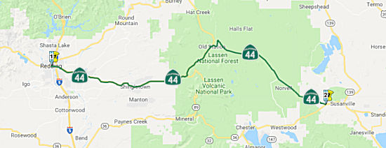 From Route 299 at Redding to Route 36 west of Susanville,
via the vicinity of Lassen Volcanic National Park.
From Route 299 at Redding to Route 36 west of Susanville,
via the vicinity of Lassen Volcanic National Park.
 Post 1964 Signage History
In 1963, Route 44 was defined as "(a) Route 5 at Redding to Lassen Volcanic National Park. (b) Lassen Volcanic National Park to Route 36 west of Susanville."
In 1964, it was reported that a new Route 44 bypass alignment of Palo
Cedro east towards Millville was completed in October 1964. A new
freeway alignment of Route 44 originating from US 99/Market Street in
Redding eastward over the Sacramento River was cited to be under
construction. This was completed and opened in 1969, seemingly
concurrent with the completion of I-5 in the area.
(Source: Gribblenation Blog (Tom Fearer), "California State Route 44 and California State Route 440", September 2020)
In 1988, Chapter 106 combined these into a single segment ("Route 5 at Redding to Route 36 west of Susanville, via the vicinity of Lassen Volcanic National Park.")
In 1999, the routing was changed from starting at Route 5 near Redding to starting at Route 299 at Redding (AB 1650, Ch. 724, 10/10/99).
In 2002, a highway location routing for Route 299 was adopted along Lake Boulevard from Route 273 to I-5. Concurrent with this action, the segment of Route 273 from Route 299 at Market Street to Route 273 at Lake Boulevard will be cosigned Route 273/Route 299. The former Route 299 segment from Route 299 at Market Street to I-5 will be designated as Route 44.
Chris Sampang noted that before the extension of Route 44 into downtown Redding (and the removal of the Route 299/I-5 multiplex from Route 44 north to Lake Boulevard), Route 44 east began at the cloverleaf ramp where Route 299 east merged onto I-5 north; Route 44 west ended when the ramps from I-5 merged onto the Route 299 freeway. Now that Route 44 has been extended on the former Route 299 freeway, the legislative definition (of Route 44 beginning at Route 299) has not changed, but the streets leading from the former Route 299 freeway onto Route 273 do not directly connect to the current Route 299/Route 273 multiplex. Based on Google Street View, Route 44 is co-signed with Route 273 along Market Street from Eureka Way south to Shasta and Tehama Streets (the ramps leading to the freeway) (i.e., it still begins at Former Route 299).
 Pre 1964 Signage History
 The history of what would become Route 44 starts in 1909,
when the portion of LRN 20 between Weaverville and Redding was defined. In
1915, the portion of LRN 20 between US 101 and Weaverville was added. This
connected in Redding with LRN 28 (defined in 1909), and ran to Alturas.
This is now US 299 (and more history is on that page), but the original
signage plans in 1934 were for route from US 101 to Alturas to be Route 44. However, the designation of that route as US 299 changed those plans.
That designation occurred at the same time as the redesignation of Route 7
to US 395; US 299 meets US 395 in Alturas.
The history of what would become Route 44 starts in 1909,
when the portion of LRN 20 between Weaverville and Redding was defined. In
1915, the portion of LRN 20 between US 101 and Weaverville was added. This
connected in Redding with LRN 28 (defined in 1909), and ran to Alturas.
This is now US 299 (and more history is on that page), but the original
signage plans in 1934 were for route from US 101 to Alturas to be Route 44. However, the designation of that route as US 299 changed those plans.
That designation occurred at the same time as the redesignation of Route 7
to US 395; US 299 meets US 395 in Alturas.
The history of what would become the current Route 44 starts when in
1933, when LRN 20 was extended east from Redding to Lassen Volcanic
National Park. This route was to be signed as Route 440. This
extension of LRN 20 was meant to reach the northern terminus of Lassen
Park Highway which had been completed through Lassen Volcanic National
Park in 1931.
(Source: Gribblenation Blog (Tom Fearer), "California State Route 44 and California State Route 440", September 2020)
When US 299 was signed in 1935, Route 44 was resigned to the new routing for LRN 20. It ran between US 99 (LRN 3) in Redding and Manzanita Lake.
Route 440 originated on the outskirts of Redding near the east bank of
the Sacramento River at US 299. The original alignment of Route 440
split from US 299 east of the 1908 Redding Free Bridge near what is now
the intersection of Parkview Avenue and Hartnell Avenue. From US 299
the route of Route 440 followed modern, Cypress Avenue, Church Creek Road,
Hartnell Avenue and Old 44 Drive to east to Millville.
(Source: Gribblenation Blog (Tom Fearer), "California State Route 44 and California State Route 440", September 2020)
In the 1938 timeframe, there was a three phase project to improve US 99/US 299/LRN 3 north of downtown Redding and the Sacramento River.
Phase 1 included the completion of the 795 foot long plate girder 1935
Sacramento River Bridge. The 1935 Sacramento River Bridge likely
played a huge factor in why the original Route 44 was reassigned as US 299
during 1935. Phase 2 included a new direct alignment of US 99/US 299/LRN 3
on Market Street from the north bank of the Sacramento River to Sulpur
Creek, which was completed in December 1935. Phase 3 was completed
during July 1937 between Sulpur Creek and Boulder Hill. The Phase 3
project included a new interchange where US 299/LRN 28 split towards
Alturas. The shift in US 299 extended Route 440 west over the 1908
Redding Free Bridge via what is Smile Place and Parkview Avenue to US 99/Market Street south of downtown Redding. It was during the transition
to US 299 that Route 440 was resigned as Route 44.
(Source: Gribblenation Blog (Tom Fearer), "California State Route 44 and California State Route 440", September 2020)
The 1908 Redding Free Bridge remained in service until 1951 when it was
closed. The 1908 Redding Free Bridge was condemned in 1955 and
removed during 1956. The 1908 Redding Free Bridge was a 320 foot
long through truss design that also was part of very early LRN 3 during
the Pacific Highway era. The 1908 Redding Free Bridge was a
replacement for the 1884 Smile Place Bridge which washed out in 1906.
(Source: Gribblenation Blog (Tom Fearer), "California State Route 44 and California State Route 440", September 2020)
 In 1947, it was announced that construction of a 1.5 mile new route for Route 44 east of US 99 along
with a new bridge over the Sacramento River was budgeted for 1948.
This new alignment of Route 44 is what is now modern day Cypress Avenue in
Redding east over the Sacramento River to Hartnell Avenue.
In 1947, it was announced that construction of a 1.5 mile new route for Route 44 east of US 99 along
with a new bridge over the Sacramento River was budgeted for 1948.
This new alignment of Route 44 is what is now modern day Cypress Avenue in
Redding east over the Sacramento River to Hartnell Avenue.
(Source: Gribblenation Blog (Tom Fearer), "California State Route 44 and California State Route 440", September 2020)
In 1959, Legislative Chapter 1062 extended LRN 20 eastward with the following two new segments, the first of which became part of Route 44:
In 1963, the Division of Highways released a map that shows how the old
Route 44 and the new freeway alignment of Route 44 would interact with the
US 99 / I-5 Freeway. What is intriguing about this map is that it shows
Route 44 was originally on Cypress and Hartnell Avenue prior to the
freeway rerouting; after the rerouting, it was along Shasta and Tehama.
(Source: via Joel Windmiller, 2/10/2023)
From the Old Oregon Trail exit in east Redding through Palo Cedro and Millville, there is an "Old 44 Drive" that apparently was bypassed when the Route 44 freeway and expressway were built (~ SHA R3.619 to SHA R10.777). The newer portion of Route 44 includes a Super-Two type interchange at Deschutes Road south of Palo Cedro.
 Status
Currently Route 44 begins a freeway at Route 299 (SHA L0.0R), traveling east until reaching Old Oregon Trail (SHA R4.286, note R0.00 is at I-5). Freeway status ends at that intersection.
Redding Improvements
In August 2005, the CTC considered improvements to Route 44 in Shasta County to increase capacity and improve operations and safety in Redding.
In his 2006 Strategic Growth Plan, Governor Schwartzenegger proposed improvements to the Route 299/Route 44/Route 36 area. These would complete "Buckhorn" to allow STAA trucks to travel direct from I-5 at Redding to US 101 near Eureka and into the Port of Humboldt, now prohibited due to the existing curvilinear alignment that causes truck off tracking. This is the only viable alternative to get STAA trucks into the north coast. STAA trucks cannot access the Port on US 101 north due to environmental restrictions at Richardson's Grove that pre-empt major improvements to the route. Route 44 widening reduces congestion in the Redding urbanized area and also improves inter-regional through movement for people and goods.
In 2007, the CTC considered a number of requests for funding from the Corridor Mobility Improvement Account (CMIA). None were recommended for funding. These requests were: widening the route to 6 lanes from Dana to Downtown, and extending the four lane freeway to Palo Cedro (Stillwater) (~ SHA R0.157 to SHA R6.986).
In June 2017, the CTC authorized SHOPP funding for the following project: Shasta 02-Sha-44 R4.6/R6.4 $5,770,000 Route 44: Near Palo Cedro, from Clough Creek bridge to 0.6 mile west of Deschutes Road overcrossing. Outcome/Output: Improve at-grade intersection operations and safety by constructing an overcrossing at Stillwater Road with right-turn-only in and out movements to Route 44. Future consideration of funding approved under Resolution E-05-14; August 2005.
The SAFETEA-LU act, enacted in August 2005 as the reauthorization of TEA-21, provided the following expenditures on or near this route:
In June 2016, the CTC authorized $2,700,000 for a project on Route 44 in Shasta County (PM 44.9/45.5) near Viola, from 1.7 miles to 1.1 miles west of North Battle Creek Reservoir Road. Outcome/Output: Provide standard shoulders, and improve roadway alignment, cross slope, and clear recovery zone to increase safety and reduce the number and severity of collisions.
In October 2017, the CTC added the following into the SHOPP: 02-Sha-44 51.6/52.2: On Route 44 in Shasta County: Near Viola, from 0.4 mile east to 1.1 mile east of Bridge Creek Road. Improve curve.
In December 2006, the CTC considered a resolution to vacate right of way in the county of Shasta, about 4.3 miles northeasterly of the junction of Route 44 and Route 89, consisting of right of way no longer needed for State highway purposes. (approx SHA 52.767)
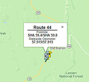
Hat Creek Bridge (02-Sha-44, PM 59.4/59.8)
 In May 2018, the CTC approved for future consideration of funding a project for which a
Negative Declaration (ND) has been completed: Route 44 in Shasta County.
Replace existing bridge on Route 44 near the community of Old Station.
(PPNO 3843) (02-Sha-44, PM 59.4/59.8) This project is located on Route 44
near the community of Old Station in Shasta County and proposes demolition
and removal of the Hat Creek Bridge. The project also proposes roadway
widening and culvert, guardrail, and sign installation. The project
proposes to address various issues regarding the deterioration of the
bridge and its current design standards which could lead to permit load
limitations and/or bridge closure. The proposed project is estimated to
cost $5.2 million in construction capital. The project is fully funded and
is currently programmed in the 2018 State Highway Operation and Protection
Program (SHOPP) for an estimated total of $9.8 million which includes
Construction (capital and support) and Right-of-Way (capital and support).
Construction is estimated to begin in Fiscal Year (FY) 2018-19. The scope,
as described for the preferred alternative, is consistent with the project
scope programmed by the California Transportation Commission (Commission)
in the 2016 SHOPP.
In May 2018, the CTC approved for future consideration of funding a project for which a
Negative Declaration (ND) has been completed: Route 44 in Shasta County.
Replace existing bridge on Route 44 near the community of Old Station.
(PPNO 3843) (02-Sha-44, PM 59.4/59.8) This project is located on Route 44
near the community of Old Station in Shasta County and proposes demolition
and removal of the Hat Creek Bridge. The project also proposes roadway
widening and culvert, guardrail, and sign installation. The project
proposes to address various issues regarding the deterioration of the
bridge and its current design standards which could lead to permit load
limitations and/or bridge closure. The proposed project is estimated to
cost $5.2 million in construction capital. The project is fully funded and
is currently programmed in the 2018 State Highway Operation and Protection
Program (SHOPP) for an estimated total of $9.8 million which includes
Construction (capital and support) and Right-of-Way (capital and support).
Construction is estimated to begin in Fiscal Year (FY) 2018-19. The scope,
as described for the preferred alternative, is consistent with the project
scope programmed by the California Transportation Commission (Commission)
in the 2016 SHOPP.
(Source: CTC Agenda, May 2018 Agenda Item 2.2c(1))
In October 2018, the CTC approved a request for an additional $1,178,000 for the State Highway Operation Protection Program (SHOPP) Bridge Rehabilitation project (PPNO 3483) on Route 44, in Shasta County, to award the construction contract. This project is located on Route 44 in Shasta County, in and near Old Station. The project limits extend from 0.1 mile west to 0.3 mile east of Sugar Loaf Drive at Hat Creek Bridge. The project will replace the existing three-span Hat Creek Bridge with a new, single-span bridge, and realign the existing highway to connect with the new bridge. The performance measure is a one bridge replaced. The contract award status is pending approval of this request for supplemental funds by the Commission. If the Commission approves this request, construction would begin in November 2018; the anticipated working time is 85 working days, to be completed in one construction season.
The project was programmed in the 2016 SHOPP for
$5,180,000 for Construction Capital and $1,530,000 for Construction
Support. The Engineer’s Estimate (EE) was completed on March 9, 2018
using available historical and current market trend data at that time and
resulted in a higher estimated construction cost. In May 2018, the
Commission approved project funds based on the higher EE and allocated
$5,397,000 for Construction Capital and $1,670,000 for Construction
Support. The project was advertised on May 14, 2018 and bids were opened
on July 24, 2018. Five bids were submitted, and the lowest of the five
bids was significantly higher than the allocated funds. The amount needed
to award the contract, based on the lowest responsible bidder, is
$6,575,000 for Construction Capital. This bridge will be constructed using
Accelerated Bridge Construction (ABC) techniques to reduce impacts to the
environment and the traveling public, and to ensure completion of the
project in one season. For a successful ABC at this limited access
location, the bridge was designed as a pre-cast concrete box girder that
can be prefabricated off-site, then installed at the site quickly. For
this scenario, the project was estimated accordingly. However, the lowest
biddor came in with a higher bid for two reasons: (1) The bid was higher
due to the limited bridge site access, and the specialized equipment and
labor force needed to install it; (2) The bid was higher because of the
shortage of pre-cast concrete girder suppliers. At the end of June 2018,
the Department was experiencing higher bidding prices throughout Northern
California due to the limited pool of contractors bidding on Department
and other non-Department contracts. In addition, there has been a
decreasing number of subcontractors available to prime contractors for
specialized construction items. While this was factored in the EE when it
was updated in March 2018, it can be concluded that the estimate was still
undervalued as the current trends were beyond expectations. The Department
has reviewed the bid results for possible mathematical or material
unbalancing in accordance with 23 CFR 635.102, and 23 CFR 635.114. The bid
appears to be mathematically balanced and there is no evidence of material
unbalancing of the low bid.
(Source: October 2018 CTC Agenda Item 2.5e.(2))
Curve Improvement Near Bridge Creek Road (02-Sha-44 51.6/52.2)
") In January 2019, the CTC approved the following support allocation: 02-Sha-44
51.6/52.2 PPNO 3673. Proj ID 0217000045. Route 44 Near Viola, from 0.4
mile east to 1.1 miles east of Bridge Creek Road. Curve improvement.
Allocation: PS&E $810,000.
In January 2019, the CTC approved the following support allocation: 02-Sha-44
51.6/52.2 PPNO 3673. Proj ID 0217000045. Route 44 Near Viola, from 0.4
mile east to 1.1 miles east of Bridge Creek Road. Curve improvement.
Allocation: PS&E $810,000.
(Source: January 2019 CTC Minutes, Agenda Item 2.5b.(2a) Item 3)
In May 2020, the CTC was informed about the following
allocation: $3,564,000 02-Sha-44 51.6/52.2. PPNO 02-3673 ProjID 0217000045
EA 2H990. On Route 44 near Viola, from 0.4 mile east to 1.1 miles east of
Bridge Creek Road. Outcome/Output: Improve safety by realigning curves and
correcting cross slope, widening lanes and shoulders, increasing clear
recovery zone and sight distance, and replacing drainage systems. This
project will reduce the number and severity of collisions. (As part of
this allocation request, the Department is requesting to extend the award
of the construction contract an additional 6 months beyond the 6 month
deadline.) Allocation Date: 03/13/20.
(Source: May 2020 CTC Agenda, Agenda Item 2.5f.(3)
#2)
Old Station Curve Improvement (02-Las-44 PM 6.5/7.1)
 In December 2020, the CTC amended the 2020 SHOPP to add the following Collision
Reduction project: 02-Las-44 6.PM 5/7.1 PPNO 02-3796. ProjID 0220000106.
EA 1J570. On Route 44 Near Old Station, from 6.5 miles east to 7.1 miles
east of Shasta County line. Curve improvement. Programmed
allocations: $660K PA&ED; $650K PS&E; $90K R/W Sup; $660 Const
Sup; $70K R/W Cap; $2,950K Const Cap. Total: $5,080K Begin Const 8/2/2023
In December 2020, the CTC amended the 2020 SHOPP to add the following Collision
Reduction project: 02-Las-44 6.PM 5/7.1 PPNO 02-3796. ProjID 0220000106.
EA 1J570. On Route 44 Near Old Station, from 6.5 miles east to 7.1 miles
east of Shasta County line. Curve improvement. Programmed
allocations: $660K PA&ED; $650K PS&E; $90K R/W Sup; $660 Const
Sup; $70K R/W Cap; $2,950K Const Cap. Total: $5,080K Begin Const 8/2/2023
(Source: December 2020 CTC Agenda, Agenda Item
2.1a.(1a) #26)
In December 2020, the CTC approved the following SHOPP
Support Phase allocation: $660,000 for PA&ED for 02-Las-44 PM 6.5/7.1.
PPNO 02-3796 ProjID 0220000106 EA 1J570. Route 44 Near Old Station, from
6.5 miles east to 7.1 miles east of Shasta County line. Curve
improvement. (Concurrent Amendment under SHOPP Amendment 20H-004; December
2020.)
(Source: December 2020 CTC Agenda, Agenda Item
2.5b.(2a) #3)
In December 2021, the CTC approved the following
SHOPP Support Phase Allocation: 02-Las-44 6.5/7.1. PPNO 02-3796; ProjID
0220000106; EA 1J570. Route 44 Near Old Station, from 6.5 miles east to
7.1 miles east of Shasta County line. Curve improvement. Allocation: R/W
SUP $90,000. Withdrawn prior to the CTC Meeting.
(Source: December 2021 CTC Agenda, Agenda Item
2.5b.(2a) #1)
In May 2022, the CTC approved the following
pre-construction phase SHOPP allocation: $740,000. 02-Las-44 6.5/7.1. PPNO
02-3796; ProjID 0220000106; EA 1J570. Route 44 Near Old Station, from 6.5
miles east to 7.1 miles east of Shasta County line. Curve improvement.
Allocation: FY22-23: PS&E $650,000; R/W Sup $90,000.
(Source: May 2022 CTC Agenda, Agenda Item 2.5b.(2a)
#4)
In August 2023, the CTC approved the following SHOPP
Construction Phase allocation: $3,610,000. 02-Las-44 6.5/7.1. PPNO
02-3796; ProjID 0220000106; EA 1J570. Route 44 Near Old Station, from 6.5
miles east to 7.1 miles east of Shasta County line. Outcome/Output:
Improve safety by realigning curve and creating clear recovery area.
This project will reduce the number and severity of collisions.
Preliminary Engineering: Budget / Expended: PA&ED
$660,000 / $525,778; PS&E $650,000 / $499,123;
R/W Sup $90,000 / $71,941. CEQA - CE, 3/1/2022;
Re-validation 6/20/2023. NEPA - CE, 3/1/2022; Re-validation 6/20/2023. EA
1J570/PPNO 02-3796 combined with EA 3H820/PPNO 02-3706 for construction
under EA 3H82U/Project ID 0223000011. Two month allocation time extension
for CONST and CON ENG approved under Waiver 23-72; June 2023. Allocation
(Programmed / Funded): CON ENG $660,000 / $660,000;
CONST $2,950,000 / $2,950,000.
(Source: August 2023 CTC Agenda, Agenda Item 2.5b.(1) #5)
Worley Ranch Curve Improvement near Susanville 02-Las-44 31.9/32.6
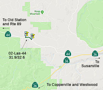 The following project was included in the final adopted 2018 SHOPP in March 2018: PPNO 3609. 02-Lassen-44 31.9/32.6. On Route 44. Near Susanville, from 0.3 mile west to 0.4 mile east of Big
Springs Road. Curve improvement. Begin Con: 10/23/2018. Total Project
Cost: $5,175K.
The following project was included in the final adopted 2018 SHOPP in March 2018: PPNO 3609. 02-Lassen-44 31.9/32.6. On Route 44. Near Susanville, from 0.3 mile west to 0.4 mile east of Big
Springs Road. Curve improvement. Begin Con: 10/23/2018. Total Project
Cost: $5,175K.
In August 2018, the CTC approved $3,755,000 in
SHOPP funding for Lassen 02-Las-44 31.9/32.6 Route 44: Near Susanville,
from 0.3 mile west to 0.4 mile east of Big Springs Road. Outcome/Output:
Improve safety by realigning roadway curves, improving roadside clear
recovery zone and sight distance, and modifying drainage and fencing. This
project will reduce the number and severity of collisions.
(Source: August 2018 CTC Agenda Item 2.5f.(3) Item
3)
In September 2019, Caltrans District 2 reported
that work has been completed on the Worley Ranch Curve Improvement Project
on Route 44 in Lassen County (approx. 6 mi. west of the junction with
Route 36). The project improved a half mile of curve, added clear recovery
area, and modified/added drainage and culverts.
(Source: Caltrans District 2 Tweet, 9/16/2019)
 Naming
Portions are the "Feather Lake Highway". This is named by location.
 Dickerson Memorial Highway") The portion of Route 44 from East Street to Victor Avenue
(~ SHA L0.315R to SHA R1.242) in the City of Redding is named the "Richard
“Dick” Dickerson Memorial Highway". It was named in
memory of Richard “Dick” Dickerson, who had an exemplary
career in law enforcement and as a government leader with service both in
the California State Assembly and the Redding City Council. Dickerson
served in the Assembly from 1998 to 2002, inclusive, representing the 2nd
Assembly District, which included the northern California Counties of
Colusa, Glenn, Shasta, Siskiyou, Sutter, Tehama, Trinity, and parts of the
Counties of Butte and Yolo. As a result of redistricting, the County of
Shasta, which includes the City of Redding, is now in the 1st Assembly
District. Dickerson, a former 30-year law enforcement officer, brought
commonsense experience to the office and became a voice for crime victims
during his first term as vice chair of the Assembly Committee on Public
Safety. Dickerson served as vice chair of the Assembly Committee on Water,
Parks, and Wildlife during both of his terms in the Assembly. In
negotiations with the Governor during his first term, Dick Dickerson
secured $20 million to complete studies on aboveground water storage as a
major concession for the legislative passage of water bond legislation.
Dickerson was a staunch supporter of the proposed Sites Reservoir in
Colusa County and raised awareness among the Members of the Legislature
that additional storage was needed to meet the water supply needs of a
growing state. Along with the Northern California Water Association, he
successfully pushed forward the audit of California’s land
acquisition policies. While in the Assembly, Dickerson retained a seat on
the Assembly Committee on Natural Resources and authored legislation to
remove vegetation that had become hazardous fuel so it could be used as
energy-producing biomass. As a member of the Assembly Committee on Budget
specializing in the resources area, Dick Dickerson obtained $4.58 million
for the Department of Forestry and Fire Protection and the Department of
Corrections and Rehabilitation, known at the time as the Department of
Corrections, to pay for the reactivation of fire crews composed of
nonviolent inmates from 17 conservation camps throughout California. These
inmates were utilized for assistance with fighting fires, emergency flood
work, and environmental restoration, with seven of the camps located in
northern California and five located within Assembly Member
Dickerson’s district. During his time in the Assembly, Dickerson sat
on more committees than any other Republican member. His committee
assignments throughout his term in office included chair of the Assembly
Committee on Veterans Affairs, vice chair of the Committee on Water,
Parks, and Wildlife, and member of the Committees on Natural Resources,
Public Safety, Budget, Governmental Organization, Insurance, Health, and
Energy Costs and Availability. In the wake of the September 11, 2001,
tragedy, Dick Dickerson was appointed to the Task Force on Terrorism.
Dickerson served on nine select committees, including CALFED, Juvenile
Justice, Air and Water Quality, California Indian Nations, California
Wine, Protection of Inland Waterways, Rural Economic Development,
Department of Motor Vehicles, and Gun Violence. Dickerson authored 20
bills that were enacted during his time in the Assembly. During the 2001
legislative year, he had seven bills signed into law by Governor Gray
Davis, including legislation to increase the presence of deputies and
firefighters on our streets and in our communities, to enhance the
protection of children from molesters, and to provide assistance for olive
growers in their battle against the olive fruit fly. Legislation authored
by Dickerson also established a rice industry certification system that
allowed California farmers to compete globally. Also through legislation
authored by Dickerson, local transportation dollars were returned to
counties that incurred savings on their construction projects. Dickerson
was an negotiator in the 2001 budget discussions, securing $8 million for
the economic recovery in the Klamath Basin, a permanent sales tax
exemption on agriculture and forestry equipment and parts, a permanent tax
exemption on propane and agricultural diesel, $500,000 of ongoing funding
for rural county sheriff’s departments, $70 million on tax relief
for senior citizens, and $40 million in school equalization funding. The
numerous awards and commendations Dickerson received throughout his tenure
in the Assembly attest to his stellar record of public service, including
Awards of Appreciation from the Far West Equipment Dealers Association,
Klamath Water Users Association, and Rice Producers of California. After
serving in the Assembly, Dickerson served on the Redding City Council from
2004 to 2012, inclusive, serving twice as mayor of the City of Redding.
Dickerson passed away on September 28, 2014. Named by Assembly Concurrent
Resolution 53, Res. Chapter 134, Statutes of 2015, on August 11, 2015.
The portion of Route 44 from East Street to Victor Avenue
(~ SHA L0.315R to SHA R1.242) in the City of Redding is named the "Richard
“Dick” Dickerson Memorial Highway". It was named in
memory of Richard “Dick” Dickerson, who had an exemplary
career in law enforcement and as a government leader with service both in
the California State Assembly and the Redding City Council. Dickerson
served in the Assembly from 1998 to 2002, inclusive, representing the 2nd
Assembly District, which included the northern California Counties of
Colusa, Glenn, Shasta, Siskiyou, Sutter, Tehama, Trinity, and parts of the
Counties of Butte and Yolo. As a result of redistricting, the County of
Shasta, which includes the City of Redding, is now in the 1st Assembly
District. Dickerson, a former 30-year law enforcement officer, brought
commonsense experience to the office and became a voice for crime victims
during his first term as vice chair of the Assembly Committee on Public
Safety. Dickerson served as vice chair of the Assembly Committee on Water,
Parks, and Wildlife during both of his terms in the Assembly. In
negotiations with the Governor during his first term, Dick Dickerson
secured $20 million to complete studies on aboveground water storage as a
major concession for the legislative passage of water bond legislation.
Dickerson was a staunch supporter of the proposed Sites Reservoir in
Colusa County and raised awareness among the Members of the Legislature
that additional storage was needed to meet the water supply needs of a
growing state. Along with the Northern California Water Association, he
successfully pushed forward the audit of California’s land
acquisition policies. While in the Assembly, Dickerson retained a seat on
the Assembly Committee on Natural Resources and authored legislation to
remove vegetation that had become hazardous fuel so it could be used as
energy-producing biomass. As a member of the Assembly Committee on Budget
specializing in the resources area, Dick Dickerson obtained $4.58 million
for the Department of Forestry and Fire Protection and the Department of
Corrections and Rehabilitation, known at the time as the Department of
Corrections, to pay for the reactivation of fire crews composed of
nonviolent inmates from 17 conservation camps throughout California. These
inmates were utilized for assistance with fighting fires, emergency flood
work, and environmental restoration, with seven of the camps located in
northern California and five located within Assembly Member
Dickerson’s district. During his time in the Assembly, Dickerson sat
on more committees than any other Republican member. His committee
assignments throughout his term in office included chair of the Assembly
Committee on Veterans Affairs, vice chair of the Committee on Water,
Parks, and Wildlife, and member of the Committees on Natural Resources,
Public Safety, Budget, Governmental Organization, Insurance, Health, and
Energy Costs and Availability. In the wake of the September 11, 2001,
tragedy, Dick Dickerson was appointed to the Task Force on Terrorism.
Dickerson served on nine select committees, including CALFED, Juvenile
Justice, Air and Water Quality, California Indian Nations, California
Wine, Protection of Inland Waterways, Rural Economic Development,
Department of Motor Vehicles, and Gun Violence. Dickerson authored 20
bills that were enacted during his time in the Assembly. During the 2001
legislative year, he had seven bills signed into law by Governor Gray
Davis, including legislation to increase the presence of deputies and
firefighters on our streets and in our communities, to enhance the
protection of children from molesters, and to provide assistance for olive
growers in their battle against the olive fruit fly. Legislation authored
by Dickerson also established a rice industry certification system that
allowed California farmers to compete globally. Also through legislation
authored by Dickerson, local transportation dollars were returned to
counties that incurred savings on their construction projects. Dickerson
was an negotiator in the 2001 budget discussions, securing $8 million for
the economic recovery in the Klamath Basin, a permanent sales tax
exemption on agriculture and forestry equipment and parts, a permanent tax
exemption on propane and agricultural diesel, $500,000 of ongoing funding
for rural county sheriff’s departments, $70 million on tax relief
for senior citizens, and $40 million in school equalization funding. The
numerous awards and commendations Dickerson received throughout his tenure
in the Assembly attest to his stellar record of public service, including
Awards of Appreciation from the Far West Equipment Dealers Association,
Klamath Water Users Association, and Rice Producers of California. After
serving in the Assembly, Dickerson served on the Redding City Council from
2004 to 2012, inclusive, serving twice as mayor of the City of Redding.
Dickerson passed away on September 28, 2014. Named by Assembly Concurrent
Resolution 53, Res. Chapter 134, Statutes of 2015, on August 11, 2015.
(Image source: Twitter, ANewsCafe)
 Stanley Statham") The portion of Route 44, from PM SHA R7.7 to PM SHA R9, near Oak Run in the County of
Shasta, is named the “Raymond “Stan” Stanley Statham
Memorial Highway”. It was named in memory of Raymond Stanley
Statham, who was born in Chico, California, in April 1939. In 1953,
Raymond won a contest to host a weekly program as a disc jockey on the
local radio station, KPAY, where his first words into the microphone were:
“This is Teen Time and you are listening to Stan the Man,” and
he was then known as Stan Statham for the rest of his life. Stan graduated
from Chico Senior High School in 1956 and enlisted as a member of the
131st Technical Intelligence Attachment in West Berlin, Germany, and as an
American spy during the Cold War, he earned a clearance using the cover
name Roland Stanley. Upon his honorable military discharge in 1959, Stan
came home to work as an operations supervisor for Crocker Bank in Yuba
City, but longing to return to the airwaves to be the next Dick Clark,
Stan soon secured jobs at several radio stations in Northern California,
from the low power, nondirectional signal of KAGR to KROY, “The
Pulse of Sacramento.” Stan expanded his broadcast resume into
television in 1965, accepting the title of News Director and Anchorman for
KHSL-TV in Chico, where he wrote and delivered the news for over a decade.
In 1976, Stan decided to make news instead of reporting it, and entered
the race for the California State Assembly as a Republican, winning
despite having no experience in politics; a true Mr. Statham Goes to
Sacramento story. During his 18 years in office, Stan was known by all his
legislative colleagues as a moderate, independent thinker who used his
considerable speaking talents to reach beyond partisan politics and get
things done, putting 90 new laws on the books. Motivated by the death of
his district director from a drunk driver, several of those measures were
to enhance DUI penalties, which resulted in President Ronald Reagan taking
note of his efforts and appointing Stan as a lifetime member of the
Presidential Commission on Drunk Driving, an honor bestowed on only 26
citizens as of 2022. In 1980, Stan learned that farmers were often
reluctant for liability reasons to let Senior Gleaners collect unused
crops from their fields for distribution to poor communities, so Stan
passed the “Brown Bag Act,” which today still provides
millions of dollars of free food to senior nutrition programs throughout
California. Stan’s media background became an asset to the
California State Assembly in 1989 when efforts formally began to televise
legislative sessions and Assembly Speaker Willie Brown appointed him to
chair the Committee on Televising the California State Assembly, and
gavel-to-gavel coverage started on August 6, 1990. Stan is best known for
his attempt to make Northern California the 51st state, as his advisory measure in 1992 was on 31 county ballots (of 58 possible counties) and
received a majority vote in 27 of those counties (which is less than 50%
of all counties). The results of that election encouraged him to introduce
legislation placing a question on a statewide ballot asking voters whether
they wanted California divided into three new states, and his measure,
Assembly Bill 3, was approved by the California State Assembly with a vote
of 46 to 28 on June 10, 1993. [The resolution DOES NOT mention that the
measure was not on the 1993 or 1994 ballot, indicating that the governor
vetoed the measure.] In light of the success of the split-the-state
movement, Stan decided to forgo the two remaining years of his term limit
in the California State Assembly and instead ran for Lieutenant Governor,
and after a dynamic campaign, Stan finished second in the Republican
primary. Stan was selected as President and CEO of the California
Broadcasters Association (CBA) in 1995, the trade group representing more
than 1,000 radio and television stations in California, and in that
capacity, he moderated six gubernatorial debates, including the recall
debate in 2003 with Arnold Schwarzenegger. Retiring from the CBA after 20
years, Stan roamed between his home in Sacramento and a mountain cabin in
Oak Run where his faithful dog Buster resided, writing a weekly column for
the Red Bluff Daily News, and visiting with his rural neighbors. Stan
passed away on August 1, 2020; his motto for thriving was: “Life is
what we make it to be, moment by moment.” Named by Senate Resolution
SCR 97, Res. Chapter 178, 09/13/22.
The portion of Route 44, from PM SHA R7.7 to PM SHA R9, near Oak Run in the County of
Shasta, is named the “Raymond “Stan” Stanley Statham
Memorial Highway”. It was named in memory of Raymond Stanley
Statham, who was born in Chico, California, in April 1939. In 1953,
Raymond won a contest to host a weekly program as a disc jockey on the
local radio station, KPAY, where his first words into the microphone were:
“This is Teen Time and you are listening to Stan the Man,” and
he was then known as Stan Statham for the rest of his life. Stan graduated
from Chico Senior High School in 1956 and enlisted as a member of the
131st Technical Intelligence Attachment in West Berlin, Germany, and as an
American spy during the Cold War, he earned a clearance using the cover
name Roland Stanley. Upon his honorable military discharge in 1959, Stan
came home to work as an operations supervisor for Crocker Bank in Yuba
City, but longing to return to the airwaves to be the next Dick Clark,
Stan soon secured jobs at several radio stations in Northern California,
from the low power, nondirectional signal of KAGR to KROY, “The
Pulse of Sacramento.” Stan expanded his broadcast resume into
television in 1965, accepting the title of News Director and Anchorman for
KHSL-TV in Chico, where he wrote and delivered the news for over a decade.
In 1976, Stan decided to make news instead of reporting it, and entered
the race for the California State Assembly as a Republican, winning
despite having no experience in politics; a true Mr. Statham Goes to
Sacramento story. During his 18 years in office, Stan was known by all his
legislative colleagues as a moderate, independent thinker who used his
considerable speaking talents to reach beyond partisan politics and get
things done, putting 90 new laws on the books. Motivated by the death of
his district director from a drunk driver, several of those measures were
to enhance DUI penalties, which resulted in President Ronald Reagan taking
note of his efforts and appointing Stan as a lifetime member of the
Presidential Commission on Drunk Driving, an honor bestowed on only 26
citizens as of 2022. In 1980, Stan learned that farmers were often
reluctant for liability reasons to let Senior Gleaners collect unused
crops from their fields for distribution to poor communities, so Stan
passed the “Brown Bag Act,” which today still provides
millions of dollars of free food to senior nutrition programs throughout
California. Stan’s media background became an asset to the
California State Assembly in 1989 when efforts formally began to televise
legislative sessions and Assembly Speaker Willie Brown appointed him to
chair the Committee on Televising the California State Assembly, and
gavel-to-gavel coverage started on August 6, 1990. Stan is best known for
his attempt to make Northern California the 51st state, as his advisory measure in 1992 was on 31 county ballots (of 58 possible counties) and
received a majority vote in 27 of those counties (which is less than 50%
of all counties). The results of that election encouraged him to introduce
legislation placing a question on a statewide ballot asking voters whether
they wanted California divided into three new states, and his measure,
Assembly Bill 3, was approved by the California State Assembly with a vote
of 46 to 28 on June 10, 1993. [The resolution DOES NOT mention that the
measure was not on the 1993 or 1994 ballot, indicating that the governor
vetoed the measure.] In light of the success of the split-the-state
movement, Stan decided to forgo the two remaining years of his term limit
in the California State Assembly and instead ran for Lieutenant Governor,
and after a dynamic campaign, Stan finished second in the Republican
primary. Stan was selected as President and CEO of the California
Broadcasters Association (CBA) in 1995, the trade group representing more
than 1,000 radio and television stations in California, and in that
capacity, he moderated six gubernatorial debates, including the recall
debate in 2003 with Arnold Schwarzenegger. Retiring from the CBA after 20
years, Stan roamed between his home in Sacramento and a mountain cabin in
Oak Run where his faithful dog Buster resided, writing a weekly column for
the Red Bluff Daily News, and visiting with his rural neighbors. Stan
passed away on August 1, 2020; his motto for thriving was: “Life is
what we make it to be, moment by moment.” Named by Senate Resolution
SCR 97, Res. Chapter 178, 09/13/22.
(Image source: Chico Enterprise-Record)
 The portion of Route 44 between SHA R27.882
at Wilson Hill Road and SHA 35.930 at Airport Way in the County of Shasta
is named the "Officer Jack Polen Memorial Highway". It was named
in memory of Officer Jack Polen, who was born in November 1957. Officer
Polen knew he wanted to become a California Highway Patrolman at a young
age. He joined the ROTC program at Enterprise High School, where he
graduated in 1975, and went on to earn an A.A. degree in Criminal Justice
from Shasta College and a B.A. in Criminal Justice from California State
University, Sacramento. Officer Polen graduated from the California
Highway Patrol Academy in 1980, and was stationed in the areas of Redwood
City, Woodland, and Redding before being assigned to the Route 44 beat in
2002. Officer Polen’s attitude, work ethic, and professionalism
showed in his dedication to making Route 44 as safe as it could be. During
his four years patrolling Route 44, Officer Polen drove 126,251 miles,
wrote 3,436 citations, and made 125 DUI arrests, saving many lives and
earning himself the nickname “The 44 Enforcer”. Officer Polen
lost his battle with cancer on December 9, 2013, at the age of 56. Named
by Assembly Concurrent Resolution (ACR) 135, Res. Chapter 121, Statutes of
2016 on August 16, 2016.
The portion of Route 44 between SHA R27.882
at Wilson Hill Road and SHA 35.930 at Airport Way in the County of Shasta
is named the "Officer Jack Polen Memorial Highway". It was named
in memory of Officer Jack Polen, who was born in November 1957. Officer
Polen knew he wanted to become a California Highway Patrolman at a young
age. He joined the ROTC program at Enterprise High School, where he
graduated in 1975, and went on to earn an A.A. degree in Criminal Justice
from Shasta College and a B.A. in Criminal Justice from California State
University, Sacramento. Officer Polen graduated from the California
Highway Patrol Academy in 1980, and was stationed in the areas of Redwood
City, Woodland, and Redding before being assigned to the Route 44 beat in
2002. Officer Polen’s attitude, work ethic, and professionalism
showed in his dedication to making Route 44 as safe as it could be. During
his four years patrolling Route 44, Officer Polen drove 126,251 miles,
wrote 3,436 citations, and made 125 DUI arrests, saving many lives and
earning himself the nickname “The 44 Enforcer”. Officer Polen
lost his battle with cancer on December 9, 2013, at the age of 56. Named
by Assembly Concurrent Resolution (ACR) 135, Res. Chapter 121, Statutes of
2016 on August 16, 2016.
(Image source: Record-Searchlight)
 Named Structures
 Sullivan") The Bear Creek Bridge in Shasta County, located on the portion of Route 44 between
post mile R14.445 (facing westbound) and post mile R14.489 (facing
eastbound), as the "Deputy Dennis "Skip" Sullivan Memorial Bridge".
It was named in memory of Deputy Sheriff Dennis "Skip" Sullivan, of the
Shasta County Sheriff's Office, who was killed in a traffic collision on
Route 44, on October 10, 1987, while on his way to negotiate with a
reportedly armed woman barricaded in a Mountain Gate home. Deputy Sullivan
had been performing duties as a dedicated member of the Sheriff's Office
Hostage Negotiation Team for four years. Deputy Sullivan served 11 years
with the South San Francisco Police Department, where as a sergeant he
supervised the operations division and the community relations and crime
prevention programs. Deputy Sullivan continued to exemplify professional
commitment and leadership during his assignment by designing and
implementing the South San Francisco Police Department's field training
program. Continuing his tradition of honorable and faithful service in law
enforcement, in 1981, Deputy Sullivan joined the Shasta County Sheriff's
Office. He served first as a resident deputy sheriff in the Shingletown
area of Shasta County and then as a patrol deputy sheriff at the Palo
Cedro substation. Deputy Sullivan, who was 41 years of age when he died,
was survived by a son and two daughters. Deputy Sullivan was an avid
fisherman and hunter who loved the Shasta County area and the people.
Deputy Sullivan was killed when his vehicle collided with a semitruck on
Route 44 east of Shingletown. As Deputy Sullivan was responding to the
report of shots fired, heading west near Inwood Road, the trailer of an
eastbound truck tipped over onto his small pickup. Witnesses report that
Deputy Sullivan tried to avoid the trailer by moving to the extreme right
of the road. The impact of the collision sheared off the top of the pickup
and forced the pickup off the highway onto the north side of Route 44.
Named by Assembly Concurrent Resolution 39, Resolution Chapter 40, on June
27, 2011.
The Bear Creek Bridge in Shasta County, located on the portion of Route 44 between
post mile R14.445 (facing westbound) and post mile R14.489 (facing
eastbound), as the "Deputy Dennis "Skip" Sullivan Memorial Bridge".
It was named in memory of Deputy Sheriff Dennis "Skip" Sullivan, of the
Shasta County Sheriff's Office, who was killed in a traffic collision on
Route 44, on October 10, 1987, while on his way to negotiate with a
reportedly armed woman barricaded in a Mountain Gate home. Deputy Sullivan
had been performing duties as a dedicated member of the Sheriff's Office
Hostage Negotiation Team for four years. Deputy Sullivan served 11 years
with the South San Francisco Police Department, where as a sergeant he
supervised the operations division and the community relations and crime
prevention programs. Deputy Sullivan continued to exemplify professional
commitment and leadership during his assignment by designing and
implementing the South San Francisco Police Department's field training
program. Continuing his tradition of honorable and faithful service in law
enforcement, in 1981, Deputy Sullivan joined the Shasta County Sheriff's
Office. He served first as a resident deputy sheriff in the Shingletown
area of Shasta County and then as a patrol deputy sheriff at the Palo
Cedro substation. Deputy Sullivan, who was 41 years of age when he died,
was survived by a son and two daughters. Deputy Sullivan was an avid
fisherman and hunter who loved the Shasta County area and the people.
Deputy Sullivan was killed when his vehicle collided with a semitruck on
Route 44 east of Shingletown. As Deputy Sullivan was responding to the
report of shots fired, heading west near Inwood Road, the trailer of an
eastbound truck tipped over onto his small pickup. Witnesses report that
Deputy Sullivan tried to avoid the trailer by moving to the extreme right
of the road. The impact of the collision sheared off the top of the pickup
and forced the pickup off the highway onto the north side of Route 44.
Named by Assembly Concurrent Resolution 39, Resolution Chapter 40, on June
27, 2011.
(Image source: California Police Officers Memorial Foundation)
This route also has the following Safety Roadside Rest Areas:
 Scenic Route
 Classified Landcaped Freeway
The following segments are designated as Classified Landscaped Freeway:
| County | Route | Starting PM | Ending PM |
| SHA | 44 | L0.37 | L1.00 |
| SHA | 44 | L1.61 | L1.81 |
| SHA | 44 | R0.00 | R1.56 |
 National Trails
 This route is part of the Volcanic Legacy Scenic Byway All American Road, between Route 36 and Route
89, and between Route 44 and Route 89.
This route is part of the Volcanic Legacy Scenic Byway All American Road, between Route 36 and Route
89, and between Route 44 and Route 89.
 Freeway
[SHC 253.1] Entire route (not completly constructed). Added to the Freeway and Expressway system in 1959.
 Exit Information
 Other WWW Links
 Statistics
Overall statistics for Route 44:
 Interregional Route
[SHC 164.12] Between the east urban limits of Redding and Route 36.
 Pre-1964 Legislative Route
The routing that was to become LRN 44 was first defined in 1917 by Chapter 703, which added to the state highway system "...that certain road situated in Boulder Creek township, county of Santa Cruz... Beginning at the intersection of Main and Lorenzo Streets in the town of Boulder Creek, thence running in a NW-ly direction over the present traveled road to the Sequoia schoolhouse, thence running over the road known as the Boulder Creek and state park road to the E-ly boundary of the California Redwood Park..." This was captured in the 1935 state highway codes as:
From the intersection of Main and Lorenzo Streets in Boulder Creek to [LRN 42] at Governor's Camp in the California Redwood Park, via the Sequoia Schoolhouse and Bloom's Mill.
In 1937, Chapter 841 simplified the definition to "[LRN 116] near Boulder Creek to [LRN 42] at Governor's Camp in the California Redwood Park".
This route was signed as Route 9, but is present-day Route 236 between Boulder Creek and 8 mi N of Boulder Creek.
© 1996-2020 Daniel P. Faigin.
Maintained by: Daniel P. Faigin
<webmaster@cahighways.org>.
 Route 43
 Route 45