
 California Highways:
Click here for a key to the symbols used. An explanation of acronyms may be found at the bottom of the page.
 Routing
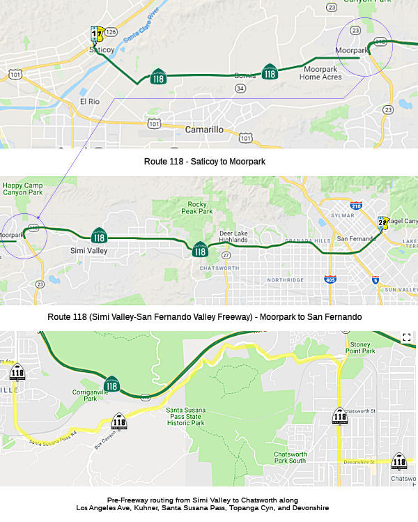 From Route 126 near Saticoy to Route 210 near San Fernando.
Note: There is a discontinuity in the postmiles for Route 118 along "New" Los Angeles Avenue—i.e., the segment of Los Angeles Avenue between the Route 118 / Route 23 freeway junction and where Route 23 continues N along Spring Rd. This is because the postmiles in the segment technically belong to Route 23.
 Post 1964 Signage History
This segment remains as defined in 1963.
In 1954, route studies were conducted for the Simi Valley Freeway (Route 118) from Desoto Avenue to the proposed Foothill Freeway (public hearing held January 9, 1964); and from the Route 126 Freeway near Saticoy to First Street near Moorpark.
In 1964, a 19.3-mile freeway routing for Route 118 was adopted between six-tenths mile west of La Vista Avenue near Saticoy and three-tenths mile east of First Street near Simi. A routing was also adopted in 1964 between 0.3 mi W of DeSoto to the future I-210 routing.
The first segment to be constructed was between Kuehner Drive in Simi Valley and Santa Susanna Avenue (likely current Topanga Canyon). In July 1964, the CHC adopted a freeway routing for the western portion of Route 118. The routing ran E-ly to beyond Winnetka Ave, then NE-ly to where it is north-of and adjacent to the DWP power transmission lines S of Rinaldi St. It continues E along this right of way, bending SE-ly E of Balboa Blvd to E of Woodley Ave, then E-ly across I-405 and I-5. It then swings NE-ly beyond Laurel Canyon Blvd, and continues N of and parallel to Paxton St. to join to I-210 just E of Foothill. This routing affected 174 fewer families while costing $2.9 milllion less than the next most favored routing. Later in 1964, a 19.3-mile freeway routing for Route 118 was adopted between six-tenths mile west of La Vista Avenue near Saticoy and three-tenths mile east of First Street near Simi.
Construction of the Simi Freeway required excavation of 8.5 million cubic yards of earth for roadway, and over 34,000 cubic yards for structure excavation. Fills ranged up to 220' in depth, requiring special drainage structures. In some areas the unique rock strata required a 3-to-1 cut, and the right of way at its widest point is 1,100' from top of cut to top of cut. The summit between Ventura County and Los Angeles county is at 1,568', with the grade being 3.6% on the Ventura side, and 5% on the Los Angeles side.
![[118 at Rocky Peak]](maps/118-rockypeak.jpg) Rocky Peak Road (~ VEN R32.414): This western half of the
interchange was graded and gated at the time of initial construction in
1968. In August 2008, Caltrans released a bid for a $9.1 million project
to construct the EB off-ramp and the WB on-ramp at Rocky Peak Road. Prior
to this construction, there were just dirt ramps. This construction was
completed in 2009.
Rocky Peak Road (~ VEN R32.414): This western half of the
interchange was graded and gated at the time of initial construction in
1968. In August 2008, Caltrans released a bid for a $9.1 million project
to construct the EB off-ramp and the WB on-ramp at Rocky Peak Road. Prior
to this construction, there were just dirt ramps. This construction was
completed in 2009.
 It was rumored that one reason the ramps on the western-half were not completed was the
proximity to The Pass Club. The Pass Club was one of six card
rooms licensed by Ventura County, and it was located just N of Rocky Peak,
where Box Canyon meets Santa Susanna Pass. It is a private residence
today. The Pass Club sits on Twilight Canyon Trail. The old stage route
through Santa Susana used to run through Twilight Canyon, and then make a
terrifying descent to the old stage stop below, once situated where the
current train tunnel is located at the east end of Corriganville. The Pass
Club property actually encompasses the acreage on the south side of the
railroad tracks. Paul Coons, a transplant from Illinois, was a partner in
an auto painting business in Los Angeles called “The Beauty
Shop.” His other partners were James Dudley “J.D.”
McCraken, and Earl Scheib. When Pal gave up on the idea of painting cars
cheaply he and Earl parted ways. Earl became a millionaire with his cheap
car painting business. About 1944 Paul Coons bought the undeveloped hill
from Frank H. & Blanche Irene Bell, who were land speculators. Soon
after Paul Coons obtained the property he purchased a gambling license.
The parcel contained 40 acres, and Paul had hoped to also build a horse
racing track, but that dream never came to fruition. By 1950 the first
club, a simple square structure, was built. Paul also built this with his
own hands, with lumber purchased from Elmwood Lumber. The Pass Club
started out doing pretty well until they came up against a local church
group around 1953, who reported them for staying open after 2:00 am, which
was against local city ordinances. The club was forced to close its doors
while they fought a battle to re-open. A new partner was found to sign for
20 percent of the business, which would allow the club to reopen. In 1959,
the club burned down. In May of 1962, Millie Coons had a whole new club
built, even bigger than the first one, and ready to open for business.
But, the battles were still not over as local church and community groups
continued to find ways to shut the Pass Club down. Eight tables were in
operation, the Ventura County limit. Eight persons were the maximum
allowed to play at each table. There was no house dealer. The only income
the club received was $1 per player per hour, which included use of chips
and cards. The ante per game was 25 cents, with a $2 bet limit, except for
the final bet, which had a ceiling of $4. Low Draw and Pan, a game similar
to Rummy, were played, but never High Draw. In November 1971, Millie
applied for a five year extension of her license. Some of the city council
members opposed this extension, citing problems with prostitution at the
east end of Simi Valley, which they tried to blame on the presence of the
Pass Club. Councilman David Sigmon disagreed, and viewed this opposition
as a form of harassment of Millie and the Pass Club. Not long after this,
due to health issues, Millie & Paul’s daughter Betty takes over
running the club until Betty’s death in 1976. From this time on
Millie and Paul’s other daughter and her husband Carol & Al
Garziano take over. In 1981 the city and county finally manage to close
down the Pass Club, and a few years later it is sold to a doctor, who
turns it into a private residence.
It was rumored that one reason the ramps on the western-half were not completed was the
proximity to The Pass Club. The Pass Club was one of six card
rooms licensed by Ventura County, and it was located just N of Rocky Peak,
where Box Canyon meets Santa Susanna Pass. It is a private residence
today. The Pass Club sits on Twilight Canyon Trail. The old stage route
through Santa Susana used to run through Twilight Canyon, and then make a
terrifying descent to the old stage stop below, once situated where the
current train tunnel is located at the east end of Corriganville. The Pass
Club property actually encompasses the acreage on the south side of the
railroad tracks. Paul Coons, a transplant from Illinois, was a partner in
an auto painting business in Los Angeles called “The Beauty
Shop.” His other partners were James Dudley “J.D.”
McCraken, and Earl Scheib. When Pal gave up on the idea of painting cars
cheaply he and Earl parted ways. Earl became a millionaire with his cheap
car painting business. About 1944 Paul Coons bought the undeveloped hill
from Frank H. & Blanche Irene Bell, who were land speculators. Soon
after Paul Coons obtained the property he purchased a gambling license.
The parcel contained 40 acres, and Paul had hoped to also build a horse
racing track, but that dream never came to fruition. By 1950 the first
club, a simple square structure, was built. Paul also built this with his
own hands, with lumber purchased from Elmwood Lumber. The Pass Club
started out doing pretty well until they came up against a local church
group around 1953, who reported them for staying open after 2:00 am, which
was against local city ordinances. The club was forced to close its doors
while they fought a battle to re-open. A new partner was found to sign for
20 percent of the business, which would allow the club to reopen. In 1959,
the club burned down. In May of 1962, Millie Coons had a whole new club
built, even bigger than the first one, and ready to open for business.
But, the battles were still not over as local church and community groups
continued to find ways to shut the Pass Club down. Eight tables were in
operation, the Ventura County limit. Eight persons were the maximum
allowed to play at each table. There was no house dealer. The only income
the club received was $1 per player per hour, which included use of chips
and cards. The ante per game was 25 cents, with a $2 bet limit, except for
the final bet, which had a ceiling of $4. Low Draw and Pan, a game similar
to Rummy, were played, but never High Draw. In November 1971, Millie
applied for a five year extension of her license. Some of the city council
members opposed this extension, citing problems with prostitution at the
east end of Simi Valley, which they tried to blame on the presence of the
Pass Club. Councilman David Sigmon disagreed, and viewed this opposition
as a form of harassment of Millie and the Pass Club. Not long after this,
due to health issues, Millie & Paul’s daughter Betty takes over
running the club until Betty’s death in 1976. From this time on
Millie and Paul’s other daughter and her husband Carol & Al
Garziano take over. In 1981 the city and county finally manage to close
down the Pass Club, and a few years later it is sold to a doctor, who
turns it into a private residence.
(Source: Anomalous Phenomena Investigations, 8/10/2016; Image source: Valley Relics Museum on FB, April 2024)
When the freeway opened, there were graded but incomplete ramps for White Oak Blvd and for Winnetka Avenue:
The following freeway-to-freeway connections were never constructed:
In 1987, it was reported that Caltrans was closer to connecting Route 23
(the Thousand Oaks-Moorpark Freeway) and Route 118 (the Simi Valley
Freeway) in Moorpark, with state and federal approval expected in Spring
1989. Once that happens, Caltrans can proceed with engineering plans and
purchase additional right of way. The state agency already owns 70% of the
needed land. Construction is to begin in 1990 and end in 1993, and the
freeway will run along Los Angeles Avenue about 200 feet from the nearest
homes. The 2.2 mile, $40 million freeway connector is one of the biggest
public works projects under way in Ventura County. The proposed route
would extend Route 23 north [Actually, it was Route 118 that was extended]
from the intersection of New Los Angeles Avenue, through about six acres
of wetlands and up to Los Angeles Avenue just east of Princeton Avenue in
the College Park area. The freeway would then swing east along Los Angeles
Avenue and hook up with the existing Route 118 just east of College View
Avenue. In a letter signed by 1,100 local residents, a homeowners group
asked Caltrans to consider an alternative route that would cut south into
ecologically sensitive wetlands and the Simi Arroyo instead of traveling
along Los Angeles Avenue. But Caltrans declined, noting that the southern
route would cost $10 million more, eat up four more acres of wetlands and
make future freeway expansion more difficult because of its remote
location. Caltrans officials also say that studying a southerly
alternative would push the entire project back two years and might
jeopardize state and federal funding. The freeway connector is on a list
of state projects to be built in the next five years and most elected
officials support the proposed route. Both Route 23 and Route 118 received
the green light from the California Highway Commission in 1964. About
seven miles of Route 23 had been completed by 1971; the Route 118 link to
Simi Valley was completed in 1975. But plans to finish and connect the
freeways stopped that year when Caltrans ran out of money. It was not
until 1988 that the connector for the two highways was again included in
the State Transportation Improvement Program and elected officials as well
as civic leaders today say they want to make sure the freeway is built.
Caltrans plans call for a four-lane highway with an exchange at New Los
Angeles Avenue and Collins Drive, an undercrossing at Los Angeles Avenue,
two two-lane bridges over the Arroyo Simi and the Southern Pacific
Railroad, and an interchange at either Princeton Avenue or Condor Drive.
The price also includes seven-foot sound walls for residential areas (at
$1 million per mile), right-of-way land, room for an additional two
freeway lanes as needed, engineering and environmental reports and
mitigation measures that the agency is required by law to take. Caltrans
must create six acres of new wetlands to replace the federally protected
wetland that will be paved over for the freeway, and plant 300 oak trees
to replace 150 that lie in the construction path. Moorpark College manages
and maintains the site which is used as a nature center by the
environmental science program. The project involves moving about 1.8
million cubic yards of dirt and the use of 60,000 cubic yards of concrete,
and includes seven bridges, rising to a maximum height of almost 100 feet.
They will carry traffic across the Southern Pacific railroad tracks, the
Arroyo Simi and Moorpark’s surface streets. The project, initially
budgeted at $33 million, was slated for completion in April 1993, but bad
winter weather and the need to clean up a large waste dump along the route
delayed the work and pushed the cost up to about $39 million, and pushed
completion to October 1993.
(Source: Los Angeles Times, 12/17/1987; LA Times 4/20/1991;
When the freeway to freeway connection was made between Route 118 and Route 23 in 1993, there were some interesting road name changes. Previously, the freeway portion of Route 118 ended at College View. The surface routing ran out of Simi Valley along Easy Street and Los Angeles to Collins, and then continued along Los Angeles curving S and then W to Spring Road (where Los Angeles became High Street). Route 118 then ran S along Spring to Los Angeles Avenue, continuing W along Los Angeles to Ventura. At the intersection of Los Angeles and Spring, Los Angeles Ave was extended E to Route 23 as "New Los Angeles Avenue". When the freeway-to-freeway connection was completed and opened, it was constructed on top of the old portion of Los Angeles Avenue between Collins and Princeton Ave. The "surface" route then was changed to run up Collins to Campus Park Dr and over to Princeton. Princeton was upgraded between Campus Park Dr and where it met Los Angeles, and Los Angeles Avenue was renamed Princeton Ave, until, as before it turned into High Street at Spring. This allowed "New" Los Angeles Avenue to drop the "New", and the interchange at the Route 118/Route 23 join became simply "Los Angeles Avenue".
Note that the original plan was for Route 23 to be freeway all the way to Santa Paula. As part of that plan, there would have been a full connection between Route 23 and Route 118, with Route 118 continuing E/W Northerly of Los Angeles Avenue on a new alignment to meet the Route 232 freeway between Santa Clara and Vineyard Avenue, remaining on new alignment Westerly of Los Angeles to Route 126. This is shown in a 1983 Thomas Guide in my possession.
 Pre 1964 Signage History
 This segment is one of the original signed routes dating
back to 1934. Before the freeway, it ran along Telephone Avenue in Ventura
(while Route 126 was on Telegraph), Wells Road (nee Los Angeles Avenue,
nee Del Norte Ave), Los Angeles Avenue, Santa Susanna Pass Road, and
Devonshire Blvd. It then ran N along Sepulveda to Brand, N on Brand into
the city of San Fernando. It jogged N on San Fernando Rd a bit to Maclay,
and then N on Maclay to Foothill Blvd. The portion between Route 126 and
I-5 was defined in 1933; the remainder was defined in 1909. A small
portion in Ventura was LRN 154 until 1957.
This segment is one of the original signed routes dating
back to 1934. Before the freeway, it ran along Telephone Avenue in Ventura
(while Route 126 was on Telegraph), Wells Road (nee Los Angeles Avenue,
nee Del Norte Ave), Los Angeles Avenue, Santa Susanna Pass Road, and
Devonshire Blvd. It then ran N along Sepulveda to Brand, N on Brand into
the city of San Fernando. It jogged N on San Fernando Rd a bit to Maclay,
and then N on Maclay to Foothill Blvd. The portion between Route 126 and
I-5 was defined in 1933; the remainder was defined in 1909. A small
portion in Ventura was LRN 154 until 1957.
It appears there may also have been a spur of Sign Route 118 along Tierra Rejada from Madera Road to Sunset Valley (Sign Route 23), at least according to a 1941 USGS Map.
This segment was LRN 9 and was signed as Sign Route 118 when state routes were first signed in 1934 (Jct. US 101 near El Rio to Jct. US 66 at Pasadena, via San Fernando). However, LRN 9 was defined as starting at US 101 near Montalvo; the route that went to near El Rio was LRN 154 along what is now Route 232. However, none of the maps show Sign Route 118 along Vineyard.
It appears that before Devonshire was completed across the valley, LRN 9 (future Sign Route 118) turned at Zelzah and went across Chatsworth (at least according to a 1923 map).
According to a 1943 USGS map, there was a spur of Sign Route 118 that ran along from Wood Road and US 101A along Wood Road to Oxnard Road (5th Street), and then along 5th, Pleasant Valley Road, and Lewis (Somis Road) to Somis and Sign Route 118. This was LRN 153. There isn't confirmation of this signage after 1943. It was signed as Route 34 after 1964. The same map also shows Sign Route 118 continuing along Oxnard Road (5th) to US 101A in Oxnard, although this doesn't appear to correspond to a state highway.
Devonshire Street was named for the Devonshire area of Britain, after beginning life in 1917 as Santa Susana Pass Road. Brand was named after Leslie Brand, a street car magnate and developer who lived in the Glendale area and subdivided Mission Hills. Maclay was named after Charles Maclay, town builder and former state Senator, who was the founder of San Fernando.
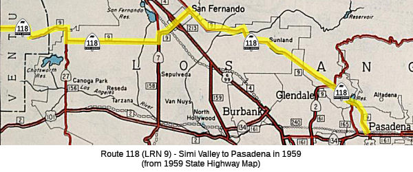 Unlike today's Route 118, which ends in San Fernando,
Sign Route 118 originally went all the way from Ventura to Pasadena,
making it a key connecting route (and an alternative to LRN 2 and US 101).
It ran along LRN 9. LRN 9 was originally defined in 1909 running from San
Bernardino westward to LRN 4 (what became US 99) in San Fernando. LRN 9
was extended westward to LRN 2 (US 101) near Montalvo (modern day Ventura)
in 1933. LRN 9 was signed as Sign Route 118 from its western terminus
(Montalvo, later Saticoy) to Pasadena, and as US 66 from Pasadena to San
Bernardino.
Unlike today's Route 118, which ends in San Fernando,
Sign Route 118 originally went all the way from Ventura to Pasadena,
making it a key connecting route (and an alternative to LRN 2 and US 101).
It ran along LRN 9. LRN 9 was originally defined in 1909 running from San
Bernardino westward to LRN 4 (what became US 99) in San Fernando. LRN 9
was extended westward to LRN 2 (US 101) near Montalvo (modern day Ventura)
in 1933. LRN 9 was signed as Sign Route 118 from its western terminus
(Montalvo, later Saticoy) to Pasadena, and as US 66 from Pasadena to San
Bernardino.
In 1957, the definition of LRN 9 was changed to start at LRN 79 (Sign Route 126), taking over the former second segment of LRN 154. At that time, Telephone Road was dropped from the state highway system. It is unclear if signage for Sign Route 118 moved to the LRN 154 segment, or remained on Telephone Road. State highway maps from post 1957 are not detailed enough to show that signage; the USGS maps continue to show Sign Route 118 along Telephone Road.
In the Chatsworth area, when Sign Route 27 (Topanga Canyon Blvd) originally met LRN 9 (Sign Route 118) at Devonshire Blvd, it changed names to Santa Susanna Pass Road, and continued as Sign Route 118. In 1964 during the great renumbering, Route 27 was extended to end at the Route 118 freeway. The original Santa Susana Pass Road remained, with a right turn onto the older routing just before the incline up the hill started. In the mid-1990s, a new intersection was created for Santa Susana Pass Road and Topanga Canyon Blvd, and the bypassed older segment (original LRN 9) became Old Santa Susana Pass Road.
 The Division of Highways began studies for Route 118 in the mid-1950s. The
route had the potential to cross many communities in the valley:
Chatsworth, Northridge, Granada Hills, Sepulveda (now North Hills),
Pacoima, Arleta, and the edges of the City of San Fernando. Pacoima, along
with Watts, was the only area in the entire City of Los Angeles that
accepted GI loans from “colored” people. With 70% residents of
color, Pacoima became by the mid-1950s the only substantive racially
diverse enclave in the San Fernando Valley — the vast majority of
which otherwise was white. Arleta was also a bit more diverse (but was
impacted more by the construction of I-5), and San Fernando was more
traditionally hispanic than black. As the freeway routing was developed,
opposition from Pacoima’s whiter neighbors in Chatsworth, Granada
Hills, Mission Hills, and Northridge gained momentum. In these areas
to the west, civic organizations, Valley State College (now California
State University, Northridge), chambers of commerce, and homeowners
associations battled each other and put heavy pressure on the Division of
Highways to reroute the proposed freeway out of their neighborhoods. The
Division of Highways presented four route alternatives (color-coded as
Orange, Green, Blue, and Red) over the course of two hearings. Publicized
to white audiences, these hearings drew a combined audience of over 2,000
but neither sought out nor focused on Pacoima. Citing lower costs and less
residential destruction, the Division of Highways ultimately chose a
combination of the Blue and Red routes for Route 118 in the north San
Fernando Valley. With little, if any, recorded input or discussion from
Pacoima residents, the selection reflected the routing preferences of the
neighborhoods to the west. Some Black residents attribute the lack of
activism to a lack of timely notification and due process. They felt
blindsided, and it was too late by the time planners’ intentions for
the freeway route were known. Note that much of the Red route was through
the foothill community of Porter Ranch, which had not yet been built out.
Analysis by UCLA shows that the unchosen route through Pacoima would have
displaced around 400 more people in Pacoima, but the chosen route targeted
areas of color: 85% of households displaced were of color, versus 49% for
the unchosen route.
The Division of Highways began studies for Route 118 in the mid-1950s. The
route had the potential to cross many communities in the valley:
Chatsworth, Northridge, Granada Hills, Sepulveda (now North Hills),
Pacoima, Arleta, and the edges of the City of San Fernando. Pacoima, along
with Watts, was the only area in the entire City of Los Angeles that
accepted GI loans from “colored” people. With 70% residents of
color, Pacoima became by the mid-1950s the only substantive racially
diverse enclave in the San Fernando Valley — the vast majority of
which otherwise was white. Arleta was also a bit more diverse (but was
impacted more by the construction of I-5), and San Fernando was more
traditionally hispanic than black. As the freeway routing was developed,
opposition from Pacoima’s whiter neighbors in Chatsworth, Granada
Hills, Mission Hills, and Northridge gained momentum. In these areas
to the west, civic organizations, Valley State College (now California
State University, Northridge), chambers of commerce, and homeowners
associations battled each other and put heavy pressure on the Division of
Highways to reroute the proposed freeway out of their neighborhoods. The
Division of Highways presented four route alternatives (color-coded as
Orange, Green, Blue, and Red) over the course of two hearings. Publicized
to white audiences, these hearings drew a combined audience of over 2,000
but neither sought out nor focused on Pacoima. Citing lower costs and less
residential destruction, the Division of Highways ultimately chose a
combination of the Blue and Red routes for Route 118 in the north San
Fernando Valley. With little, if any, recorded input or discussion from
Pacoima residents, the selection reflected the routing preferences of the
neighborhoods to the west. Some Black residents attribute the lack of
activism to a lack of timely notification and due process. They felt
blindsided, and it was too late by the time planners’ intentions for
the freeway route were known. Note that much of the Red route was through
the foothill community of Porter Ranch, which had not yet been built out.
Analysis by UCLA shows that the unchosen route through Pacoima would have
displaced around 400 more people in Pacoima, but the chosen route targeted
areas of color: 85% of households displaced were of color, versus 49% for
the unchosen route.
(Sources: "An interactive history of California’s freeways, redlining and racism", Transfers, 2/28/2025; "Freeway Revolts & Racially Exclusive Participatory Planning: A History
of Organized Opposition to Freeway Construction in Pacoima",
UCLA Institute of Transportation Studies; "The Implications of Freeway Siting in California: Four Case Studies on the Effects of Freeways on Neighborhoods of Color", UCLA Institute of Transportation Studies: Loukaitou-Sideris, Anastasia;Handy,
Susan L.;Ong, Paul M.;Barajas, Jesus M.;Wasserman, Jacob L.;Pech,
Chhandara;Garcia Sanchez, Juan C.;Ramirez, Andres F.;Jain,
Aakansha;Proussaloglou, Emmanuel;Nguyen, Andrea;Turner,
Katherine;Fitzgibbon, Abigail;Kaeppelin, Francois;Ramirez,
Felipe;Arenas, Marc, 2023)
 Before 1964, Route 118 continued down Foothill Blvd.
Around the Devils Gate Reservoir, there was a small freeway segment [since
bypassed, now called Oak Grove Drive, specifically the segment across the
front of the reservoir], connecting it Canada Ave, and then to Lincoln
Ave, then down Fair Oaks to Colorado St. in Pasadena, where it ended at US 66. Portions of Foothill Blvd have been known as Horsethief Trail,
Michigan Avenue, Tujunga Valley Avenue and Mulholland Street. Before that
freeway segment was built, it appears to have run (this is in the reverse
direction): N up Lincoln Avenue to Montana, turned W to Arroyo Blvd, N to
La Canada Verdugo Road (renamed Oak Grove Drive), W over the dam,
continued NW past Oak Grove Park on the R, skirted Flintridge Country Club
on the E, joined Michigan Ave (now Foothill Blvd), continued W. The entire
portion from the intersection of Cañada Ave and Montana to Foothill
Blvd is now under I-210; the former Country Club is now the site of two
high schools. As of the late 1950s, Route 11 (now Route 110) turned NW
from Lincoln on Cañada Ave to Montana, then followed (according to
the map) Montana two blocks to Arroyo. The present Cañada Ave. still
joins Montana at approximately the same place, but I-210 is built over the
continuation W to La Cañada Verdugo Road, now under the overpass at
Arroyo Blvd. Before the construction of Cañada Avenue between Montana
and Lincoln, Sign Route 118 used Montana over to Lincoln. Linda Vista, in
this area, was Sign Route 11.
Before 1964, Route 118 continued down Foothill Blvd.
Around the Devils Gate Reservoir, there was a small freeway segment [since
bypassed, now called Oak Grove Drive, specifically the segment across the
front of the reservoir], connecting it Canada Ave, and then to Lincoln
Ave, then down Fair Oaks to Colorado St. in Pasadena, where it ended at US 66. Portions of Foothill Blvd have been known as Horsethief Trail,
Michigan Avenue, Tujunga Valley Avenue and Mulholland Street. Before that
freeway segment was built, it appears to have run (this is in the reverse
direction): N up Lincoln Avenue to Montana, turned W to Arroyo Blvd, N to
La Canada Verdugo Road (renamed Oak Grove Drive), W over the dam,
continued NW past Oak Grove Park on the R, skirted Flintridge Country Club
on the E, joined Michigan Ave (now Foothill Blvd), continued W. The entire
portion from the intersection of Cañada Ave and Montana to Foothill
Blvd is now under I-210; the former Country Club is now the site of two
high schools. As of the late 1950s, Route 11 (now Route 110) turned NW
from Lincoln on Cañada Ave to Montana, then followed (according to
the map) Montana two blocks to Arroyo. The present Cañada Ave. still
joins Montana at approximately the same place, but I-210 is built over the
continuation W to La Cañada Verdugo Road, now under the overpass at
Arroyo Blvd. Before the construction of Cañada Avenue between Montana
and Lincoln, Sign Route 118 used Montana over to Lincoln. Linda Vista, in
this area, was Sign Route 11.
(Image source: 1963 Highway Map of Pasadena, via German Robles on FB, July 2024)
Note: the use of this route as "Temporary" I-210 is discussed with Route 210.
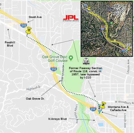 A portion of this (from Foothill Blvd. near Gould Ave.
east to near the intersection of Montana Ave. and Cañada Ave.) was
constructed to freeway standards in 1957, but was bypassed and
decommissioned as "freeway" in 1974, when I-210 was constructed over the
Arroyo Seco.
A portion of this (from Foothill Blvd. near Gould Ave.
east to near the intersection of Montana Ave. and Cañada Ave.) was
constructed to freeway standards in 1957, but was bypassed and
decommissioned as "freeway" in 1974, when I-210 was constructed over the
Arroyo Seco.
By 1935, the signage for Sign Route 118 replaced was then US 99 on LRN 9
between San Fernando and Pasadena, with US 99 being rerouted along LRN 4.
This move occurred because the State Legislature removed restrictions that
prevented State Funds from being used to maintain urban roadways. This
change by the Legislature led to the addition of numerous urban highways
being adopted including the extension of LRN 9 to Ventura. Originally US 99 had bypassed downtown Los Angeles in favor of using LRN 9 from San
Fernando via the following route:
(Source: Gribblenation Blog - California State Route 118)
According to Gribblenation, 1935 maps show all the roadways described
above between Pasadena and Los Angeles signed as Foothill Boulevard. The
alignment of Route 118 appears to take a simplified route from US 66/LRN 9
on Colorado Street up Fair Oaks Boulevard and Lincoln Avenue to Foothill
Boulevard on a bypass of Altendena.
(Source: Gribblenation Blog - California State Route 118)
A 12.5-mile portion of the route between Los Angeles Avenue at Madera Road in Ventura County and De Soto Avenue in the City of Los Angeles was adopted by the California Highway Commission in 1962. The remaining portions to the west and to the east of this adopted segment are currently under planning study with a target date for adoption late in 1963. First construction was planned for the five-mile unit of the adopted route between the easternmost end of Simi Valley and De Soto Avenue in the West San Fernando Valley. An estimated $12,000,000 was believed necessary to finance that construction.
 Status
Planned as freeway from Route 126 to Route 23 but never upgraded. Freeway from Route 23 to Route 210.
Somis Reconfiguration
![[118/34 Jct]](maps/118-somis.jpg) In February 2009, the CTC received notice of preparation
of an EIR for reconstruction of the Route 118/Route 34 interchange in
Somis. The proposed project would construct roadway improvements that
include relocating and realigning Route 118 at Donlan Road, and adding a
westbound left-turn lane in the westbound direction of Route 118, an
eastbound auxillary lane, and interchange ramp improvements along portions
of Route 118 and Route 34 intersection in the community of Somis in
Ventura County. The project is included in the State Highway Operation and
Protection Program Long Lead Project List. Future funding for project
design, right of way, and construction will be programmed later pending
completion of the environmental clearance. The alternatives being
considered are:
In February 2009, the CTC received notice of preparation
of an EIR for reconstruction of the Route 118/Route 34 interchange in
Somis. The proposed project would construct roadway improvements that
include relocating and realigning Route 118 at Donlan Road, and adding a
westbound left-turn lane in the westbound direction of Route 118, an
eastbound auxillary lane, and interchange ramp improvements along portions
of Route 118 and Route 34 intersection in the community of Somis in
Ventura County. The project is included in the State Highway Operation and
Protection Program Long Lead Project List. Future funding for project
design, right of way, and construction will be programmed later pending
completion of the environmental clearance. The alternatives being
considered are:
Moorpark officials reviewed the draft EIR, and believe that it fails to take into account a plan by Ventura County to realign Donlon Road so that it joins to make a four-way intersection where the two state highways meet. They also believe that it does not provide mitigation of an expected increase in truck traffic and related air quality, noise and safety impacts on Route 118 as a result of projects planned by Caltrans.
In October 2012, it was reported that Caltrans has dropped plans to revamp the Somis interchange. Caltrans will include its decision in the project's environmental impact report that will be issued by the end of November 2012. The county now wants to realign Donlon to make a four-way intersection at Route 118 and Somis Road. According to the county, Caltrans can make "easy, quick and cheap fixes" in conjunction with the county project, such as lengthening a left-turn lane from westbound Route 118 to Somis Road.
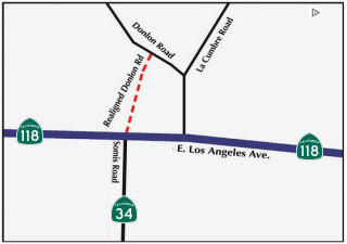 In March 2015, it was reported that the intersection of Route 118 and Somis Road will start
construction in May to improve the traffic flow and create a fourway stop.
In February, 2015 the county paid $88,000 for a one-third-acre lot next to
the intersection. The right of way will allow road crews to reroute Donlon
Road in order to create the four-way stop. The Ventura County Public Works
Agency has already removed 25 eucalyptus trees on the newly purchased
land. Project engineer Chris Hooke said it was critical to cut the trees
down before nesting season starts in March. Some of the birds that nest in
the trees include the endangered American peregrine falcon and the golden
eagle. Hooke said the birds’ nests would have halted the project
until the summer. Donlon Road currently connects 200 feet east of the
intersection; the side road makes it difficult for drivers making
left-hand turns. Additionally, the length of the left-turn lane on Route 118 will be nearly tripled, from 120 to 350 feet. Construction at the
intersection is expected to take eight months, at a cost of about $2.5
million.
In March 2015, it was reported that the intersection of Route 118 and Somis Road will start
construction in May to improve the traffic flow and create a fourway stop.
In February, 2015 the county paid $88,000 for a one-third-acre lot next to
the intersection. The right of way will allow road crews to reroute Donlon
Road in order to create the four-way stop. The Ventura County Public Works
Agency has already removed 25 eucalyptus trees on the newly purchased
land. Project engineer Chris Hooke said it was critical to cut the trees
down before nesting season starts in March. Some of the birds that nest in
the trees include the endangered American peregrine falcon and the golden
eagle. Hooke said the birds’ nests would have halted the project
until the summer. Donlon Road currently connects 200 feet east of the
intersection; the side road makes it difficult for drivers making
left-hand turns. Additionally, the length of the left-turn lane on Route 118 will be nearly tripled, from 120 to 350 feet. Construction at the
intersection is expected to take eight months, at a cost of about $2.5
million.
In April 2016, it was reported that the Donlon Road
realignment project in Somis had been completed. The job involved moving
Donlon Road 200 feet to the west to align with the existing traffic signal
on Route 118 at Somis Road/ Route 34.
(Source: Moorpark Acorn, 4/1/2016)
In April 2021, it was reported that 5 drainage culverts (Fox
Barranca/North St. (~ 07-VEN-118-10.089), La Cumbre Creek Culvert
(07-VEN-118-11.1), the Long Canyon Creek underpass (07-VEN-118-012.98),
Wailing Siren Culvert (07-VEN-118-13.76), and Meijo Creek
(07-VEN-118-014.53)) had been retrofitted into wildlife crossings. The
retrofitting made them accessible for wildlife and added fencing to funnel
animals to them. Overall, the effort has involved an initial year-long
study of wildlife movement, mortality, and crossing use, then the
acquisition of funds for the retrofits followed by the construction work
of modifying the culverts and adding fencing, and finally
post-construction wildlife monitoring. Some culverts that had almost no
use prior to the retrofitting of ramps are now seeing wildlife use almost
daily. At the Long Canyon underpass, an almost 10-foot-tall cement wall on
its north end proved to be a hindrance for wildlife attempting to cross
beneath the highway. The mitigation here consisted of building a long
concrete ramp allowing animals to walk down into the culvert. Fencing was
also installed on the north side of the road to funnel animals onto the
ramp, while the south side is a natural funnel, so no fencing was used. At
another culvert, dubbed Fox Barranca, there was previously a 6-foot drop
with a pool of water at the bottom. Caltrans workers installed
“riprap,” which filled in the drop with boulders of varying
sizes. This created a natural-looking ramp into the culvert, especially
after soil fills in the spaces around the rocks and plants begin to grow.
Animals have started to regularly use this natural ramp as well. Caltrans
maintenance crews are reporting picking up less roadkill along the stretch
that includes the five crossings. One of those crossings was a black bear
in a box culvert known as LaCumbre, where a steel ramp was installed. The
retrofits are mostly complete and are now being monitored by wildlife
biologists using remote cameras to assess how well their efforts have
succeeded. As many as 10,000 images are being captured each month by
remote cameras.
(Sources: Goldrush Cam, 4/16/2021; CBS Local, 4/14/2021; Caltrans DIME)
In November 2019, it was reported that the city of Moorpark is exploring
options to increase the safety of Route 118 in Moorpark (VEN 15.571 / VEN
R17.894). Since the city incorporated in 1983, Moorpark has dedicated more
than $16 million to improvements on Los Angeles Avenue. The
roadway’s funding, though, was mostly supported through
Moorpark’s residential and commercial developments that are required
to make contributions to both the city’s traffic mitigation efforts
and the Route 118 improvements. The money has helped the city make
enhancements to the area by widening parts of the roadway, adding traffic
signals and planting new landscape. But, according to Moorpark, the
thoroughfare still has a long way to go until it meets the city’s
expectations. High on the city’s priorities list is eliminating
unsafe driving and truck traffic along the highway; widening the road
between Spring Road and Moorpark Avenue; and adding a raised median on
parts of the avenue, among other improvements. Moorpark officials are also
working with the Ventura County Transportation Commission and the
California Department of Transportation (Caltrans) to expand the
frequently-used roadway and make it safer. Since 2016, the agencies have
worked together to re-pave Route 118 and to re-program traffic signals to
increase speeds and reduce wait times. Caltrans also approved a city
project to install a raised concrete median between the Route 23 Freeway
and Spring Road (technically, part of Route 23). The city is also working
to complete a right-of-way designation along the roadway to widen L.A.
Avenue to three lanes in each direction between Spring Road and Moorpark
Avenue. The city hopes it can finish designs for those plans by the end of
2020. In the future, Caltrans plans to devote $17 million to resurface
Route 118 between Spring Road and Montair Drive. The city is also pushing
for Caltrans to install a traffic signal at Millard Street. Looking to the
future, Caltrans plans to devote more than $20 million to replace the two
truck scale facilities west of the city. The project, though, is still in
the planning stages.
(Source: Moorpark Acorn, 11/22/2019)
Route 118 Arroyo Simi Overhead Suicide Prevention (07-Ven-118 T18.4/T18)
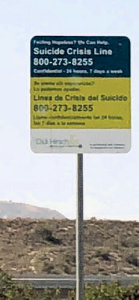 In June 2018, more than a dozen suicide-prevention signs line the overpass that connects the
Simi Valley portion of Route 118 with the N/S portion that connects with
Route 23 at Los Angeles Avenue. The signs were installed in the hope of
saving lives along the 2.2-mile stretch of road that crosses above Los
Angeles and Princeton avenues. Since the overpass was built in 1993 and
the installation of the signs in 2018, 11 people have jumped off the two
100-foot-tall bridges, according to the Moorpark Police Department. In
2014, after a 57-year-old Simi Valley man jumped from the overpass, the
Moorpark City Council sent a letter to Caltrans asking them to safeguard
the bridge with a fence. However, a fence is not feasible because these
are curving bridges and a fence would block the driver’s line of
sight. Three years later, in December 2017, Caltrans held an environmental
hearing on the future widening of Route 118 between Los Angeles Avenue and
Madera Road. During the meeting, Sean Corrigan, the city’s public
works director, said Moorpark would like to address the safety of the
overpass as part of the freewaywidening project. In the months that
followed, Caltrans decided to create signs for the bridges with help from
Didi Hirsch Mental Health Services, a nonprofit agency that provides mental health, substance abuse and
suicide prevention services to Southern California communities. Together,
the agencies developed freeway-appropriate signs in English and Spanish
with information about mental health resources and the National Suicide
Prevention Lifeline number. A total of 16 signs were installed between
July 5 and 12, 2018 with help from the California Highway Patrol.
In June 2018, more than a dozen suicide-prevention signs line the overpass that connects the
Simi Valley portion of Route 118 with the N/S portion that connects with
Route 23 at Los Angeles Avenue. The signs were installed in the hope of
saving lives along the 2.2-mile stretch of road that crosses above Los
Angeles and Princeton avenues. Since the overpass was built in 1993 and
the installation of the signs in 2018, 11 people have jumped off the two
100-foot-tall bridges, according to the Moorpark Police Department. In
2014, after a 57-year-old Simi Valley man jumped from the overpass, the
Moorpark City Council sent a letter to Caltrans asking them to safeguard
the bridge with a fence. However, a fence is not feasible because these
are curving bridges and a fence would block the driver’s line of
sight. Three years later, in December 2017, Caltrans held an environmental
hearing on the future widening of Route 118 between Los Angeles Avenue and
Madera Road. During the meeting, Sean Corrigan, the city’s public
works director, said Moorpark would like to address the safety of the
overpass as part of the freewaywidening project. In the months that
followed, Caltrans decided to create signs for the bridges with help from
Didi Hirsch Mental Health Services, a nonprofit agency that provides mental health, substance abuse and
suicide prevention services to Southern California communities. Together,
the agencies developed freeway-appropriate signs in English and Spanish
with information about mental health resources and the National Suicide
Prevention Lifeline number. A total of 16 signs were installed between
July 5 and 12, 2018 with help from the California Highway Patrol.
(Source: TO Acorn, 8/2/2018)
In December 2022, the CTC amended the following project
into the SHOPP: 07-Ven-118 T18.4/T18.8. PPNO 07-5977; ProjID 0722000235;
EA 38790. Route 118 In Moorpark, at Arroyo Simi Overhead №s 53-0331R
and 53-0331L. Install suicide deterrent fences along bridges. Allocation
($ × 1,000): PA&ED $384; PS&E $1,209; R/W Sup $14; Con Sup
$1,710; R/W Cap $25; Const Cap $7,402; Total $10,744. Begin Const:
10/9/2025. Concurrent COS allocation under Resolution FP-22-33; December
2022. In a letter from the City of Simi Valley that accompanied this
agenda item, it was noted: "ln 2021, a Suicide Prevention Task Force
formed to seek physical and community-based solutions to deter suicides
and suicide attempts at the Arroyo Simi Overhead Bridges, which connect
Route 118 and Route 23 in Ventura County. The task force includes
representatives and elected members of the Ventura County Transportation
Commission (VCTC), Caltrans, City of Moorpark, California Highway Patrol,
Ventura County Sheriff's Office, Ventura County Suicide Prevention
Council, and the Didi Hirsch Suicide Prevention Center. The months of
discussions have resulted in a plan to construct a safety barrier system
along the Arroyo Simi Overhead Bridges, as well as community-based
measures intended to prevent suicides and suicide attempts."
(Source: December 2022 CTC Agenda, Agenda Item
2.1a.(1a) #14)
In December 2022, the CTC approved the following
pre-construction phase SHOPP allocation: $384,000. 07-Ven-118 T18.4/T18.8.
PPNO 07-5977; ProjID 0722000235; EA 38790. Route 118 In Moorpark, at
Arroyo Simi Overhead №s.53-0331R and 53-0331L. Install suicide
deterrent fences along bridges. Concurrent Amendment under SHOPP Amendment
22H-005; December 2022. Allocation: PA&ED $384,000.
(Source: December 2022 CTC Agenda, Agenda Item
2.5b.(2a) #9)
In August 2023, the CTC approved the following SHOPP
SB1 Primary Class Project Pre-Construction Phase (environmental support,
design, and R/W support) allocation: $1,315,000. 07-Ven-118 T18.4/T18.8.
PPNO 07-5977; ProjID 0722000235; EA 38790. Route 118 In Moorpark, at
Arroyo Simi Overhead №s.53-0331R and 53-0331L. Install suicide
deterrent fences along bridges. Allocation (Programmed / Allocated):
PS&E $1,156,000 / $1,301,000; R/W Sup $14,000 / $14,000.
(Source: August 2023 CTC Agenda, Agenda Item 2.5b.(2b) #16)
In August 2024, the CTC had on its agenda the following
construction-phase allocation for the following SHOPP project, but it was
withdrawn prior to the meeting: $4,955,000. 07-Ven-118 T18.4/T18.8.
PPNO 07-5977; ProjID 0722000235; EA 38790. Route 118 In Moorpark, at
Arroyo Simi Overhead №s 52-0331R and 52-0331L. Outcome/Outputs:
Install suicide deterrent fences along bridges to improve safety. CEQA -
CE, 6/1/2023; Re-validation 6/28/2024 NEPA - CE, 6/1/2023; Re-validation
6/28/2024. Allocation: CON ENG $1,603,000; CONST $7,562,000. Withdrawn prior to CTC Meeting.
(Source: August 2024 CTC Agenda, Agenda Item 2.5b.(1) #27)
In September 2024, it was reported that athe California
Transportation Commission is set to consider final funding next month to
construct a safety barrier system on the Arroyo Simi Bridge, a notorious
overpass that has seen multiple suicides. Located where the Route 118
freeway curves from N/S to E/W, above the junction with Route 23 in
Moorpark, the bridge can tower as high as 90 feet above Princeton Avenue,
depending on the terrain. Since its completion in 1993, the Arroyo Simi
Bridge has been the site of 14 suicides, with three occurring since 2018,
according to the California Highway Patrol. In addition, several deaths
have resulted from accidents or undetermined causes. In a bid to prevent
further tragedies, the CTC is working on plans to install a protective
barrier fence on the bridge. In 2022, the CTC allocated about $878 million
to improve the state’s transportation infrastructure. The Arroyo
Simi Bridge project was included in this initiative, with $384,000
earmarked for Caltrans to begin preliminary work on the safety barrier.
The entire project is estimated to cost $10.7 million, with $7.4 million
going toward construction and $3.3 million dedicated to project management
and engineering. According to the Ventura County Transportation Commission
in Sept. 2024, the safety barrier would be similar to the mesh-style fence
installed on the Cold Springs Canyon Bridge on Route 154 in Santa Ynez
Valley, a site where over 50 suicides have occurred since 1963. The Arroyo
Simi Bridge project began in July 2022, and the environmental review,
engineering and design phases have since been completed. The final design
for the barrier fence was recently finalized, and the CTC is expected to
approve the remaining funding at its Oct. 18 meeting. If approved,
construction will begin in May 2025 and be completed by November next
year.
(Source: The Acorn, 9/27/2024)
In October 2024, the CTC approved the following SHOPP
construction-phase allocation: $6,253,000. 07-Ven-118 T18.4/T18.8. PPNO
07-5977; ProjID 0722000235; EA 38790. Route 118 In Moorpark, at Arroyo
Simi Overhead №s 52-0331R and 52-0331L. Outcome/Outputs:
Install suicide deterrent fences along bridges. CEQA - CE, 6/1/2023;
Re-validation 6/28/2024 NEPA - CE, 6/1/2023; Re-validation 6/28/2024.
Allocation: CON ENG $1,603,000; CONST $7,562,000.
(Source: October 2024 CTC Agenda, Agenda Item 2.5b.(1) #21)
In January 2026, it was reported that work has
restarted on the long-awaited suicide deterrent fence along the Arroyo
Simi Bridge in Moorpark. Construction first kicked off in November 2025
after a contractor delay, and sections of the fence were already visible
before holiday and weather setbacks temporarily halted progress. The
Arroyo Simi Bridge, which rises about 90 feet above Princeton Avenue, has
been the site of multiple suicides since its completion in 1993. According
to California Highway Patrol records, at least 14 people have died by
suicide on the bridge, including three since 2018. Other fatalities have
resulted from accidents or undetermined causes. Local officials and
residents have long voiced concern about the bridge’s height and
accessibility, calling for permanent safety measures to prevent further
tragedies. In response, the California Transportation Commission allocated
$6.8 million in 2022 for the design and construction of a suicide
deterrent fence. The project was originally expected to finish by February
2026, but delays may extend the timeline. It is estimated to take 95
working days, or about five months, subject to changes from weather or
material deliveries.
(Source: Moorpark Acorn, 1/18/2026)
In July 2026, it was reported that Caltrans District 7
has announced completion of the Route 118 Freeway's Arroyo Simi Bridge
Safety Barrier project. More than 6,400 feet of safety fencing has been
added to enhance public safety.
(Source: FB/City of Moorpark, 7/16/2026)
Route 118 Widening in Simi Valley
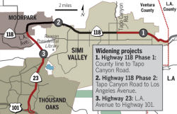 In late March 2007, ground was broken on a $46M project
to add a lane to the freeway in Simi Valley. The work, expected to take
more than two years, includes not only widening the roadway from Tapo
Canyon Road (~VEN R27.317 to VEN R32.577) as it heads east into the San
Fernando Valley, but also the construction of sound walls along the
highway and fiber optics to better regulate the flow of traffic onto
freeway onramps. The second phase of the work is to begin in mid-2008 and
includes widening the westbound portion.
In late March 2007, ground was broken on a $46M project
to add a lane to the freeway in Simi Valley. The work, expected to take
more than two years, includes not only widening the roadway from Tapo
Canyon Road (~VEN R27.317 to VEN R32.577) as it heads east into the San
Fernando Valley, but also the construction of sound walls along the
highway and fiber optics to better regulate the flow of traffic onto
freeway onramps. The second phase of the work is to begin in mid-2008 and
includes widening the westbound portion.
(Source: Ventura County Star, 3/30/2007)
In June 2007, Ventura County officials applied for an
additional $32.7 million to complete the improvements to WB Route 118. The
California Transportation Commission initially allocated $50 million for
the project but higher construction costs left only enough to add an
eastbound lane from Tapo Canyon Road in Simi Valley to the Los Angeles
County line. When the county officials originally asked for the additional
funds, the state Transportation Commission staff erroneously classified it
as a new project rather than a cost increase and recommended that the
request be rejected. If funding is turned down for the second phase, the
widening project will probably be delayed several years and the cost will
significantly increase. Local planners hope state commissioners will agree
to use a portion of funds from Proposition 1B — a $19.9-billion
statewide bond measure approved by voters last November — to finish
the widening project. Traffic on the stretch of the 118 Freeway increased
from 110,000 vehicles daily in 1998 to 117,000 today. With no improvement,
traffic planners estimate two-hour delays during morning and evening peak
periods each weekday will double by 2025. Ventura County is at a
disadvantage because it is the largest in the state without a local sales
tax earmarked for transportation projects.
(Source: Los Angeles Times, 6/6/2007)
In November 2007 and December 2007, the CTC considered a proposal to reprogram $1,206,000 for Environmental (PA&ED) for the Route 118 Widening project (New Los Angeles Avenue to Tapo Canyon Road, PPNO 3002) in Ventura County to the new Route 118 Widening Phase 2 project (Tapo Canyon Road to the Los Angeles County Line, PPNO 4006). The Route 118 Widening project between New Los Angeles Avenue and Tapo Canyon Road (PPNO 3002) was programmed in the State Transportation Improvement Program (STIP) for $4,660,000 for PA&ED with an unfunded need of over $110 million to complete the project through construction, but significant construction cost increases to higher priority projects in the region have resulted in the Caltrans and the VCTC deciding to delete the project from the STIP. The new Route 118 Widening Phase 2 project (PPNO 4006) is a much higher priority but requires funding for Design (PS&E) and Right of Way (R/W) Support. The adopting resolution of the 2006 STIP Augmentation, dated June 2007, included recognition of the high priority given by the VCTC to early programming of this project if capacity is available.
In May 2009, the Ventura County Transportation
Commission approved the allocation of $6.5 million to the ongoing widening
of eastbound Route118 through Simi Valley. It indicated that construction
will start in 2010 on phase 2: widening westbound Route 118 from three to
four lanes between Tapo Canyon and Kuehner Drive. It was funded earlier in
2009 as part of $1 billion in transportation spending approved in
Sacramento, which will also go to other transportation projects in the
county. An engineer’s estimate for the westbound Route 118 project
was $21.7 million dollars, and the Ventura County Transportation
Commission allocated the funds. However, when the California Department of
Transportation opened construction bids for the project on 11/5/2009, the
lowest qualifying bid was only $13.8 million by Sun-Valley based Security
Paving Co. The first phase of the widening project cost $46.5 million with
State Transportation Improvement Program funds, and included the addition
of sound walls, the widening of four bridges, and the addition of
communication and fiber-optic cables.
(Source: Ventura County Star, 11/19/2009)
In November 2009, the Ventura County Star reported the completion of the first widening phase of the project (from Tapo Canyon to the Los Angeles County line).
In February 2010, the CTC approved an adjustment to the allocation amount for the Route 118 Widening, Tapo Canyon to the Los Angeles County Line (Phase 2) project (PPNO 4006) in Ventura County, from $18,493,000 to $8,961,000, in accordance with Assembly Bill 608. Specifically, on May 14, 2009, the Commission approved Resolution STIP1B-A-0809-019 allocating $18,493,000 for the Route 118 Widening, Tapo Canyon to the Los Angeles County Line (Phase 2) project programmed in the State Transportation Improvement Program (STIP) with Regional Improvement Program (RIP) shares. The project was awarded on November 24, 2009, for $15,468,000 ($8,961,000 RIP and $6,507,000 Regional American Recovery and Reinvestment Act of 2009 [Recovery Act]), including supplemental work, state furnished materials, and contingencies. Section 188.8 of the Streets and Highways Code allows the Commission to adjust an allocation amount for a capital outlay project in the STIP if the construction contract award amount for the project is less than 80% of the engineer’s final estimate. As a result, Caltrans and Ventura County Transportation Commission requests a downward adjustment of the allocation from $18,493,000 to $8,961,000, with $9,532,000 to return to Ventura County’s regional share balance.
In March 2011, it was reported that the Route 118 Widening project was complete and open for traffic. Construction of phase one of the project, widening the eastbound highway from three to four lanes over a five-mile stretch from Tapo Canyon Road to the Los Angeles County line, began in 2008. Construction of phase two didn't begin until early 2010 because of funding issues. It added a new westbound lane along the same stretch, and completed the widening of the final two sections of the new eastbound lane. The second phase cost $19.1 million and was funded by Proposition 1B funds, state gasoline sales tax revenue and federal stimulus money. Phase one was completed strictly with state funds. A third phase of the project, which would widen the highway to Moorpark, is not even on the drawing board because of a lack of funds.
In February 2022, it was announced that as part of
Gavin Newsom’s $1.1 billion Clean California initiative, Caltrans is
awarding funding for beautification projects along the state highway
system. One project is the State Route 118 Simi Valley Beautification.
The project will enhance six interchanges in Simi Valley by replacing
dying ground cover with aesthetically pleasing rock cobble. Native,
drought tolerant plants to control erosion and provide pollinator habitat
will be planted in selected areas at local streets to enhance the visual
experience for the local community. As the community requested, each
interchange will receive a different plant palette and hardscape or
aesthetic motif to provide a unique place-making aesthetic to each
location. Estimated cost: $3.924 million. Estimated completion date is
June 16, 2023.
(Source: SCVNews, 2/17/2022)
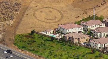 The Ventura County Star, in December 2009, had a nice article on "smiley face hill" (~ VEN R30.401). This is/was a 120-foot creation on the side of a hill in eastern Simi Valley created
originally by Sonny Klamerus, 58, of Northridge. By creating the giant
smile, it was his intention to invoke the same in drivers who passed by
the area near Yosemite Avenue and Kuehner Drive. The hill, which sits on a
10-acre site, was purchased by Palmdale 47th LLC in September 2009 from
the bank. The previous owner, Larwin Co., filed for bankruptcy protection
after putting a housing development project on hold in 2007. The face was
originally established in 1998 without the permission of its then-owner,
Mount Sinai Memorial Park (they later gave permission, as did Larwin).
Palmdale 47th finally granted permission in early 2010. The property has
changed hands several times and the area next to the hill is now marked to
be developed with 66 town houses according to the city of Simi Valley. The
new units will not obscure the grinning symbol. In 2014, Steve Apostolof,
who operates a pizza restaurant in Chatsworth, went out and bought $100
worth of solar lights, recruited some friends and illuminated Happy Face
Hill. The hillside grin has also gotten its own Facebook page, which has been "liked" nearly 7,000 times, according to page creator Brian Dennert, a world history teacher at Simi
Valley's Royal High School.
The Ventura County Star, in December 2009, had a nice article on "smiley face hill" (~ VEN R30.401). This is/was a 120-foot creation on the side of a hill in eastern Simi Valley created
originally by Sonny Klamerus, 58, of Northridge. By creating the giant
smile, it was his intention to invoke the same in drivers who passed by
the area near Yosemite Avenue and Kuehner Drive. The hill, which sits on a
10-acre site, was purchased by Palmdale 47th LLC in September 2009 from
the bank. The previous owner, Larwin Co., filed for bankruptcy protection
after putting a housing development project on hold in 2007. The face was
originally established in 1998 without the permission of its then-owner,
Mount Sinai Memorial Park (they later gave permission, as did Larwin).
Palmdale 47th finally granted permission in early 2010. The property has
changed hands several times and the area next to the hill is now marked to
be developed with 66 town houses according to the city of Simi Valley. The
new units will not obscure the grinning symbol. In 2014, Steve Apostolof,
who operates a pizza restaurant in Chatsworth, went out and bought $100
worth of solar lights, recruited some friends and illuminated Happy Face
Hill. The hillside grin has also gotten its own Facebook page, which has been "liked" nearly 7,000 times, according to page creator Brian Dennert, a world history teacher at Simi
Valley's Royal High School.
(Image source: YouTube)
There are currently plans to add new on and off ramps at
Rocky Peak Road (~ VEN R32.414): an EB off-ramp and a WB on-ramp. This
western half of the interchange was graded and gated at the time of
initial construction in 1968. This is a $9.1 million project. In August
2008, Caltrans released a bid to construct the EB off-ramp and the WB
on-ramp at Rocky Peak Road. Prior to this construction, there were just
dirt ramps. This construction was completed in 2009.
The SAFETEA-LU act, enacted in August 2005 as the reauthorization of TEA-21, authorized $2,320,000 for High Priority Project #124: Landscaping Enhancements along the Ronald Reagan Freeway, Route 118, for aesthetic purposes.
In August 2016, the CTC approved $31,477,000 for Los Angeles 07-LA-118 R0.0/R14.4 Route 118 in the city and county of Los Angeles, from Ventura County line to Route 210; also on Route 27 (Topanga Canyon Boulevard) from Devonshire Street to Route 118. Outcome/Output: Rehabilitate 65.0 lane miles of roadway to extend pavement surface life and improve ride quality. Replace approach slabs and upgrade curb ramps to meet current ADA standards.
![[Burned 118 sign]](images/118-burned-sign.jpg) In October 2003, the Simi Freeway served as a major
firebreak for a fire that started up near Route 126 in Piru, and burned as
far south as Browns Canyon and Chatsworth, as far East as Moorpark, and as
far West as Stevenson Ranch. The fire burned a number of signs on the
freeway, including the sign shown to the right (~ LA R0.5).
In October 2003, the Simi Freeway served as a major
firebreak for a fire that started up near Route 126 in Piru, and burned as
far south as Browns Canyon and Chatsworth, as far East as Moorpark, and as
far West as Stevenson Ranch. The fire burned a number of signs on the
freeway, including the sign shown to the right (~ LA R0.5).
In March 2016, SHOPP funding was approved in Los Angeles County for westbound Route 118 at Tampa Avenue Off-ramp (~ LA R4.728). Outcome/Output: Widen Off-ramp to improve intersection operations.
Reseda Offramp Sinkhole (07-LA-118 R5.8)
 The first report on the sinkhole was in March 2019 with a tweet from District 7:
"#PorterRanch: The westbound SR-118 Reseda Blvd Off-ramp is closed due to
a developing sinkhole. Caltrans geologist and maintenance are on site. The
ramp will be closed until further notice."
The first report on the sinkhole was in March 2019 with a tweet from District 7:
"#PorterRanch: The westbound SR-118 Reseda Blvd Off-ramp is closed due to
a developing sinkhole. Caltrans geologist and maintenance are on site. The
ramp will be closed until further notice."
(Source: District 7 on Twitter.Com, 3/12/2019)
In October 2020, the CTC received notice of the
following supplemental emergency G-11 allocation: $2,350,000. 07-LA-118
R5.8. PPNO 07-5608; ProjID 0720000158; EA 1XP90. Route 118 In the city of
Los Angeles, near the community of Porter Ranch, at Reseda Boulevard. On
May 7, 2020, maintenance crews discovered a localized pavement depression
and a failed culvert underneath. This project will replace the damaged
culvert, reconstruct impacted embankments, and reconstruct the damaged
roadway. Allocation: CON ENG $700,000; CONST $2,000,000. (Additional
$100,000 was allocated for right of way purposes.) Initial G-11 Allocation
07/27/2020.
(Source October 2020 CTC Agenda, Agenda Item 2.5f.(1) #13)
While engineering was in process, the depressed portion
of the roadway was blocked off. In April 2022, the growth of the sinkhole
had increased to the point where the offramp had to be closed.
(Source: District 7 on Twitter.com, 9/14/2022)
In August 2022, it was report by District 7 that they
were still awaiting a permit from the City of Los Angeles: "We are
awaiting a permit from the city of LA to begin work on the ramp and on
Rinaldi St. Once we have the permit, we will have a better idea on an
opening date."
(Source: District 7 on Twitter.Com, 8/2/2022)
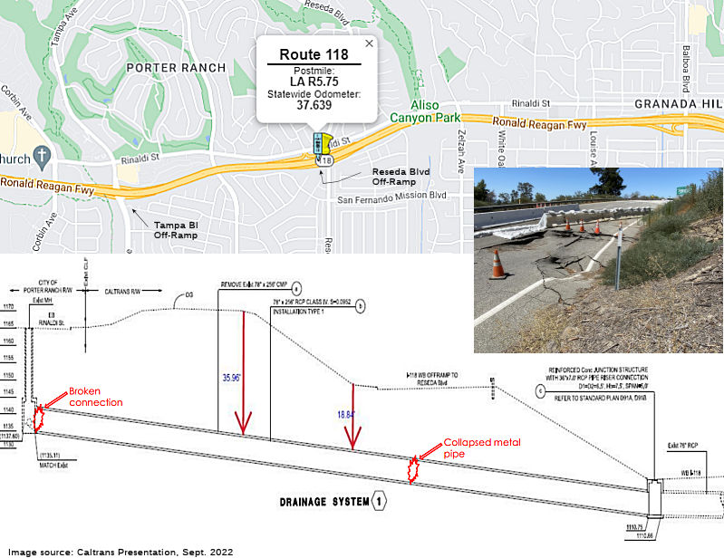
In September 2022, additional information on the
closure of the Reseda Blvd off-ramp was provided by Caltrans. The source
of the closure was the collapse of lanes two and three of the off ramp,
which was caused by a broken connection at the storm drain manhole on
Rinaldi. The broken connection was 25' underground. The drainpipe that is
underneath the off ramp had also collapsed. This resulted in pavement
separation and cracking, as well as pavement dips. The plan was to remove
and replace 260' of the damaged 78" diameter metal culvert pipe with a 78"
diameter reinforced concrete pipe. The broken connection to the storm
drain manhole on Rinaldi Street would also be repaired. The embankments
and landscaped areas would be reconstructed, and the irrigation system
would be replaced. The delay in the start of the project from the original
allocation in July 2020 was due to: (a) the required permit from the City
of Los Angeles to perform repair work on Rinaldi Street; and (b) the fact
that the procurement of the reinforced concrete pipe required the approval
from Caltrans and City. There were also delays in the fabrication of the
concrete pipe; it was due to be delivered in mid-October. Assuming the
permits are issued by the city in September 2022, the timeline for repair
was to start construction in early October 2022, with completion by the
end of 2022. The contractor would be working longer shifts 7 days a week.
(Source: Porter Ranch Neighborhood Council, 9/15/2022; Caltrans Presentation)
In January 2023, the CTC received notice of the
following supplemental emergency G-11 allocation: $2,350,000. 07-LA-118
R5.8. PPNO 07-5608; ProjID 0720000158; EA 1XP90. Route 118 In the city of
Los Angeles, near the community of Porter Ranch, at Reseda Boulevard. On
May 7, 2020, maintenance crews discovered a localized pavement depression
and a failed culvert underneath. This project will replace the damaged
culvert, reconstruct impacted embankments, and reconstruct the damaged
roadway. The initial G-11 Emergency Allocation on 07/27/2020 was
$2,700,000. This supplemental allocation of $2,350,000 (CON ENG $850,000;
CONST $1,500,000) on 12/6/2022 was necessary because the cost and
complexity of removing the existing 78 inch culvert resulted in higher
costs due to a wider excavation and longer permit approval times, as well
as a greater need for traffic control work and reconstruction of more
irrigation systems. Total: $5,050,000.
(Source: January 2023 CTC Agenda, Agenda Item 2.5f.(1) #10)
In February 2023, it was reported that the ramp, closed
for motorist safety in April 2022 due to a sinkhole. was originally
scheduled to reopen by the end of 2022, but work was delayed by winter
2022's above-average rainfall, which over-saturated the soil within the
project boundaries. The reopening has been rescheduled to mid-April 2023.
The remaining lanes on the ramp are anticipated to reopen by this summer
2023.
(Source: SCVNews, 2/17/2023)
In March 2023, there were additional failures under
Rinaldi St. that results in a sinkhole under Rinaldi.
(Source: KCAL News, 3/16/2022)
In May 2023, the Reseda Offramp reopened, and there was much rejoicing.
In October 2023, the CTC approved the following
supplemental emergency allocation for this project: $4,600,000. 07-LA-118
R5.8. PPNO 07-5608; ProjID 0720000158; EA 1XP90. Route 118 In the city of
Los Angeles, near the community of Porter Ranch, at Reseda Boulevard. On
May 7, 2020, maintenance crews discovered a localized pavement depression
and a failed culvert underneath. This project will replace the damaged
culvert, reconstruct impacted embankments, and reconstruct the damaged
roadway. The first supplemental is necessary because the cost and
complexity of removing the existing 78 inch culvert resulted in higher
costs due to a wider excavation and longer permit approval times, as well
as a greater need for traffic control work and reconstruction of more
irrigation systems. The second supplemental is necessary due to project
site damage caused by winter storm, as well as pipe replacement, restoring
utilities, and restoring landscaping and irrigation. Initial G-11
Allocation 07/27/2020: $2,700,000; Supplemental G-11 Allocation
12/06/2022: $2,350,000; Supplemental G-11 Allocation 06/28/2023:
$4,600,000; Revised Allocation: $9,650,000.
(Source: October 2023 CTC Agenda, Agenda Item 2.5f.(1) #37)
 Commuter Lanes
Commuter lanes exist on Route 118 between the Ventura County line and Route 5. These lanes were opened in March 1997, require two or more occupants, and are in operation 24 hours a day.
 Naming
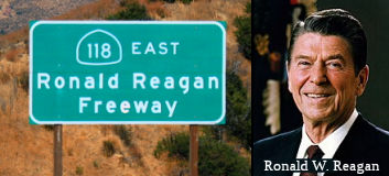 Officially, the portion of this route constructed to freeway standards (~ VEN T18.238 to LA R13.933) is named the "Ronald
Reagan Freeway" (as of 1994). The original proposal for this name
was introduced by Willie Brown on August 30, 1994 and amended August 31,
1994, as Assembly Concurrent Resolution 156. However, this version of the
bill died on the desk in November 1994. The name was reintroduced by
Senators Lockyer, Maddy, and Wright as Senate Resolution 7, amended and
enrolled December 5, 1994. Since it was neither a concurrent resolution
nor a joint resolution, it was not filed with the Secretary of State.
Ronald Reagan, for those who don't know, was the 40th President of the
United States. He was Governor of the State of California between 1967 and
1975. The rationale for choosing Route 118 is that the western end of the
Route 118 Freeway, at the time the bill was passed, is very close to the
Ronald Reagan Presidential Library.
Officially, the portion of this route constructed to freeway standards (~ VEN T18.238 to LA R13.933) is named the "Ronald
Reagan Freeway" (as of 1994). The original proposal for this name
was introduced by Willie Brown on August 30, 1994 and amended August 31,
1994, as Assembly Concurrent Resolution 156. However, this version of the
bill died on the desk in November 1994. The name was reintroduced by
Senators Lockyer, Maddy, and Wright as Senate Resolution 7, amended and
enrolled December 5, 1994. Since it was neither a concurrent resolution
nor a joint resolution, it was not filed with the Secretary of State.
Ronald Reagan, for those who don't know, was the 40th President of the
United States. He was Governor of the State of California between 1967 and
1975. The rationale for choosing Route 118 is that the western end of the
Route 118 Freeway, at the time the bill was passed, is very close to the
Ronald Reagan Presidential Library.
(Source: Shirleigh Brannon/Caltrans History
Library. Image source: Wikimedia; Wikipedia)
Until 1994, the official name for the portion in Ventura County (~ VEN T18.238 to VEN R32.577) was the "San Fernando Valley-Simi Valley Freeway", and the portion in Los Angeles County (~ LA 0.000 to LA R13.933) was the "Simi Valley-San Fernando Valley Freeway". This portion was named by Assembly Concurrent Resolution 145, Chapter 185, in 1970. The first segment opened in 1968. Simi is probably from a Chumash Indian designation for "place" or "village"; it was recorded with the present spelling as early as 1795. San Fernando refers to both the community and the mission. The mission was established in 1797 to honor Saint Ferdinand, King of Castile and Leon in the 13th century. The city was named in 1874.
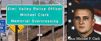 The First Street Overcrossing of Route 118 in the City of
Simi Valley (~ VEN R23.823) is named the "Simi Valley Police Officer
Michael Clark Memorial Overcrossing". It was named in memory of
Michael Clark, who was born in Massachusetts in August 1966. His family
later moved to Ventura County, and he was raised in Thousand Oaks, where
he graduated from Westlake High School in 1984. Michael Clark served in
the United States Marine Corps from December 1984 to August 1988 as a Navy
diver, assigned to “A” Company 3rd Reconnaissance Battalion
and stationed in Kaneohe Bay, Hawaii. Michael Clark achieved a life long
goal of becoming a police officer when he joined the Los Angeles Police
Department in May 1989. He was assigned to the Devonshire Division, where
he served as a patrol officer. Officer Clark later joined the Simi Valley
Police Department in March 1995, where he also served as a patrol officer.
On August 4, 1995, Officer Clark was killed in the line of duty while
handling a “check the welfare” call at the request of the
Ventura County Mental Health Department at a residence in Simi Valley,
where he was shot with a semi-automatic handgun by the person he was
attempting to assist. Officer Clark was the first Simi Valley police
officer to die in the line of duty. It was named by Assembly Concurrent
Resolution (ACR) 134, Res. Chapter 120, Statutes of 2016, on August 16,
2016.
The First Street Overcrossing of Route 118 in the City of
Simi Valley (~ VEN R23.823) is named the "Simi Valley Police Officer
Michael Clark Memorial Overcrossing". It was named in memory of
Michael Clark, who was born in Massachusetts in August 1966. His family
later moved to Ventura County, and he was raised in Thousand Oaks, where
he graduated from Westlake High School in 1984. Michael Clark served in
the United States Marine Corps from December 1984 to August 1988 as a Navy
diver, assigned to “A” Company 3rd Reconnaissance Battalion
and stationed in Kaneohe Bay, Hawaii. Michael Clark achieved a life long
goal of becoming a police officer when he joined the Los Angeles Police
Department in May 1989. He was assigned to the Devonshire Division, where
he served as a patrol officer. Officer Clark later joined the Simi Valley
Police Department in March 1995, where he also served as a patrol officer.
On August 4, 1995, Officer Clark was killed in the line of duty while
handling a “check the welfare” call at the request of the
Ventura County Mental Health Department at a residence in Simi Valley,
where he was shot with a semi-automatic handgun by the person he was
attempting to assist. Officer Clark was the first Simi Valley police
officer to die in the line of duty. It was named by Assembly Concurrent
Resolution (ACR) 134, Res. Chapter 120, Statutes of 2016, on August 16,
2016.
(Image source: VC Star; Simi PD In Memorium)
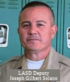 The overcrossing on Route 118 at Balboa Boulevard (~ LA R7.813) in the County
of Los Angeles is named the “Los Angeles County Sheriff’s
Deputy Joseph Solano Memorial Overcrossing”. It was named in
memory of Deputy Joseph Gilbert Solano of the Los Angeles County
Sheriff’s Department, who was tragically shot on June 10, 2019, in
the City of Alhambra and ultimately succumbed to his injuries on June 12,
2019. Deputy Solano faithfully served the residents of the County of Los
Angeles as a deputy sheriff. Deputy Solano stated that the reason he
became a law enforcement officer was to be a role model and to make a
positive difference in other people’s lives, and as a deputy
sheriff, he was praised by his peers, supervisors, and members of the
community for his tireless efforts to protect people, prevent incidents,
and serve as a leader. Named by Senate Resolution SCR 24, Resolution Chapter 85, 07/16/21.
The overcrossing on Route 118 at Balboa Boulevard (~ LA R7.813) in the County
of Los Angeles is named the “Los Angeles County Sheriff’s
Deputy Joseph Solano Memorial Overcrossing”. It was named in
memory of Deputy Joseph Gilbert Solano of the Los Angeles County
Sheriff’s Department, who was tragically shot on June 10, 2019, in
the City of Alhambra and ultimately succumbed to his injuries on June 12,
2019. Deputy Solano faithfully served the residents of the County of Los
Angeles as a deputy sheriff. Deputy Solano stated that the reason he
became a law enforcement officer was to be a role model and to make a
positive difference in other people’s lives, and as a deputy
sheriff, he was praised by his peers, supervisors, and members of the
community for his tireless efforts to protect people, prevent incidents,
and serve as a leader. Named by Senate Resolution SCR 24, Resolution Chapter 85, 07/16/21.
(Image source: CNN)
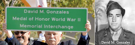 The interchange of Route 118 and
I-5 in the City of Los Angeles (~ LA R11.33R) is named the "David M.
Gonzales Medal of Honor World War II Memorial Interchange". It is
named in memory of David M. Gonzales, Private First Class (PFC), United
States Army. Gonzales was born in 1923 in East Los Angeles and raised in
Pacoima, California. David M. Gonzales joined the Army during World War II
on March 31, 1944, at Fort MacArthur, and was deployed to the Philippines
as an infantry replacement in December 1944. PFC Gonzales’ heroic
service on the Villa Verde Trail in Luzon, Philippines, on April 25, 1945,
earned him, posthumously, the Congressional Medal of Honor. On April 25,
1945, PFC Gonzales and his unit, Company A, 127th Infantry, 32nd Division,
were pinned down by enemy fire when a 500-pound bomb exploded in the
company’s perimeter, burying five men of Company A. Without
hesitation, PFC Gonzales seized an entrenching tool, and, under a hail of
fire, crawled 15 yards to his entombed comrades, while his commanding
officer, who also rushed forward to help, was struck and instantly killed
by machine gun fire. Undismayed, PFC Gonzales set to work swiftly with the
entrenching tool, and continued to dig out the five trapped men, while
enemy sniper fire and machine gun bullets struck him. After PFC Gonzales
had successfully freed one of the men, he stood up to be able to dig
faster, despite the fact that such a position exposed him to greater
danger, and while he successfully freed another man, PFC Gonzales was
mortally wounded by enemy fire as he finished liberating the third trapped
man. In the words of President Harry Truman, “Private
Gonzales’ valiant and intrepid conduct exemplified the highest
tradition of the military service”. The other two buried soldiers
were later saved when the intense enemy fire subsided. PFC Gonzales was
killed on April 25, 1945, while serving our country and saving the lives
of his comrades on the field of battle during World War II. PFC Gonzales
was survived by his then 25-year-old widow, his one-year-old son, and his
mother. Named by Senate Concurrent Resolution No. 72, Resolution Chapter
148, September 05, 2014.
The interchange of Route 118 and
I-5 in the City of Los Angeles (~ LA R11.33R) is named the "David M.
Gonzales Medal of Honor World War II Memorial Interchange". It is
named in memory of David M. Gonzales, Private First Class (PFC), United
States Army. Gonzales was born in 1923 in East Los Angeles and raised in
Pacoima, California. David M. Gonzales joined the Army during World War II
on March 31, 1944, at Fort MacArthur, and was deployed to the Philippines
as an infantry replacement in December 1944. PFC Gonzales’ heroic
service on the Villa Verde Trail in Luzon, Philippines, on April 25, 1945,
earned him, posthumously, the Congressional Medal of Honor. On April 25,
1945, PFC Gonzales and his unit, Company A, 127th Infantry, 32nd Division,
were pinned down by enemy fire when a 500-pound bomb exploded in the
company’s perimeter, burying five men of Company A. Without
hesitation, PFC Gonzales seized an entrenching tool, and, under a hail of
fire, crawled 15 yards to his entombed comrades, while his commanding
officer, who also rushed forward to help, was struck and instantly killed
by machine gun fire. Undismayed, PFC Gonzales set to work swiftly with the
entrenching tool, and continued to dig out the five trapped men, while
enemy sniper fire and machine gun bullets struck him. After PFC Gonzales
had successfully freed one of the men, he stood up to be able to dig
faster, despite the fact that such a position exposed him to greater
danger, and while he successfully freed another man, PFC Gonzales was
mortally wounded by enemy fire as he finished liberating the third trapped
man. In the words of President Harry Truman, “Private
Gonzales’ valiant and intrepid conduct exemplified the highest
tradition of the military service”. The other two buried soldiers
were later saved when the intense enemy fire subsided. PFC Gonzales was
killed on April 25, 1945, while serving our country and saving the lives
of his comrades on the field of battle during World War II. PFC Gonzales
was survived by his then 25-year-old widow, his one-year-old son, and his
mother. Named by Senate Concurrent Resolution No. 72, Resolution Chapter
148, September 05, 2014.
(Image source: Aerotech News; Wikipedia)
 Scenic Route
[SHC 263.6] From Route 23 to DeSoto Avenue near Browns Canyon.
Although this segment is eligible for Scenic Highway status, it has not yet met the criteria to be officially designated as Scenic Highway.
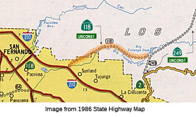 From Route 210 near Sunland to Route 249 north of La Cañada.
Post 1964 Signage History This segment remains as defined in 1963. Planned as freeway in 1965, but never constructed. Technically, this is signed along Route 210
from Paxton Street to Sunland. The traversable local routing was along Big
Tujunga Canyon between Foothill and LA County Sign Route N3 (which appears to what would
have become Route 249). There are no plans for improvement. See Route 249
for some further detailed discussion.
This segment remains as defined in 1963. Planned as freeway in 1965, but never constructed. Technically, this is signed along Route 210
from Paxton Street to Sunland. The traversable local routing was along Big
Tujunga Canyon between Foothill and LA County Sign Route N3 (which appears to what would
have become Route 249). There are no plans for improvement. See Route 249
for some further detailed discussion.
According to the 2013 Traversable Highways report, the closest roads are Big Tujunga Canyon Road with no plans for improvement.
Big Tujunga Canyon Road is approximately 13-mile-long rural highway
located mostly in the San Gabriel Mountains of Los Angeles County.
As presently configured Big Tujunga Canyon Road begins at Angeles Forest
Highway (County Sign Route N3) and extends west to Oro Vista Avenue in the Los Angeles
neighborhood of Sunland. The earliest parts of Big Tujunga Canyon Road
were constructed between Mount Gleason Road northeast to Hoyt Ranch at
Vasquez Creek in the 1890s. The highway was extended east to Big
Tujunga Dam in 1931. In 1958 Big Tujunga Canyon Road would be
extended east again from dam to a terminus at Angeles Forest Highway. In
1959 the corridor of Big Tujunga Canyon was added to the definition of
planned LRN 266. Said planned state highway was developed as a
trans-San Gabriel Mountain corridor that would have connected with US 466. During 1964, the Big Tujunga Canyon corridor would be
transferred to definition of Route 118. Ultimately the California
Highway Commission never made a formal route adoption for a State Highway
in Big Tujunga Canyon. The corridor of Big Tujunga Canyon Road was
planned to be extended west to Foothill Boulevard but ultimately only was
ever built to Oro Vista Avenue in the 1970s.
(Source: Gribblenation Blog, "Big Tujunga Canyon Road", 4/13/2026)
With respect to Big Tujunga Canyon, Scott Parker on AARoads noted (in
response to a question about whether there were plans to expand Big
Tujunga Canyon): The original canyon road emptied out onto Mt. Gleason
Ave., a 2-lane local street; its connector down into the canyon was
characterized by horseshoe curves and switchbacks—slow going. An
extension was built in the late '70's, about the time I-210 was being
constructed to the area. The idea was to skirt the floodplain below the
canyon on its south side and intersect Foothill Blvd. at the Wentworth
Ave. intersection (I-210 crossed Wentworth about a quarter-mile west of
Foothill). A number of new housing tracts were planned along the new
Tujunga Canyon extension—but that area was considered
environmentally sensitive, and those never materialized due to permit
denials. The extension was built to Oro Vista Avenue, which paralleled
Mt.Gleason to the west; canyon traffic now is diverted to that street. It
never reached Foothill; a golf course was constructed directly in its path
south of the Tujunga Creek channel.
(Source: Scott Parker (SParker) on AARoads, "Re: Planned CA 48 (ii), CA 122, CA 196, and CA 249", 4/20/2020)
Pre 1964 Signage HistoryThis routing was LRN 266 (defined in 1959) in 1963. It was not signed as Route 118.
 Classified Landcaped Freeway
The following segments are designated as Classified Landscaped Freeway:
| County | Route | Starting PM | Ending PM |
| Los Angeles | 118 | R2.66 | R8.65 |
| Los Angeles | 118 | R8.70 | R12.39 |
| Los Angeles | 118 | R12.43 | R13.93 |
| Ventura | 118 | R18.92 | R20.35 |
| Ventura | 118 | R24.16 | R28.96 |
| Ventura | 118 | R30.21 | R30.70 |
 Exit Information
 Other WWW Links
 Freeway
[SHC 253.1] Entire route. Added to the Freeway and Expressway system in 1959.
 Statistics
Overall statistics for Route 118. This information reflects Route 118 before the Route 118/Route 23 flyover connector was constructed; hence, there might be a mile or two difference in the traversable miles:
 Pre-1964 Legislative Route
In 1933, Chapter 767 defined the route from "[LRN 2] near Salinas to Coast Road near Castroville" as part of the highway system. In 1935, it was codified as LRN 118 with the definition:
This definition remained unchanged until 1963. It ran from US 101 near Salinas to Route 1 near Castroville, and is present-day Route 183.
© 1996-2024 Daniel P. Faigin.
Maintained by: Daniel P. Faigin
<webmaster@cahighways.org>.
 Route 117
 Route 119