
 California Highways:
Click here for a key to the symbols used. An explanation of acronyms may be found at the bottom of the page.
 Routing
 Post 1964 Signage History
This routing is unchanged from its 1963 definition.
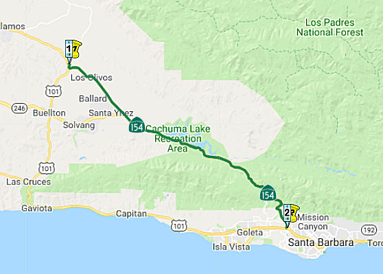
In 1964, Route 154 was realigned onto the Cold Springs Arch Bridge which
significantly straightened the approach to San Marcos Pass. Previous to
being realigned Route 150 and later Route 154 used Stagecoach Road to
traverse Cold Springs Canyon.
(Source: Gribblenation, "California State Route 150 family of highways (CA 246, CA 154, CA 192 and CA 150)", visited on 11/9/2019)
This segment of Route 154 is often referred to as a "Blood Alley". But an
interesting survey of data reported in January 2020 disputes that notion.
For the 10-year period between September 2009 and September 2019, the
collision rate along all 32 miles of Route 154 between Los Olivos and
Santa Barbara was 0.85 collisions per million vehicle miles traveled. For
that same time period, the statewide average for similar two-lane routes
was 0.78. “Similar” routes are other curvy two-lane roadways
that see close to the same amount of traffic, such as Route 166, which
twists and turns over the Sierra Madre Mountains between Santa Maria and
Bakersfield, and Route 41, the famously tricky road that brings Southern
California visitors to Yosemite. Over the same 10 years, the collision
rate on the Santa Barbara County stretch of US 101 between its northerly
and southerly junctions with Route 154 was 0.58 collisions per million
vehicle miles traveled; the state average for similar four-lane routes was
0.54. The average number of vehicles using Route 154 ranges from 11,400 a
day in the Los Olivos area to 14,000 vehicles further south near
Stagecoach Road. In recent years, the volume on Route 154 increased about
5 percent. During the same period, volumes on all state highways went up
about 10 percent. Data shows that 52 percent of collisions were caused by
Santa Barbara County residents. Of the drivers arrested for DUI north of
Paradise Road, 67 percent were county residents; among DUI offenders south
of Paradise, 60 percent were from Santa Barbara. Figures also reveal that
collisions happen every 2.5 days on average, and that the majority are
noninjury. The overall number of incidents, including fatal accidents and
DUI incidents, has remained relatively steady over the last 10 years. A
disproportionate number of collisions, however, happen in April, May, and
December, with higher numbers taking place Fridays, Saturdays, and
Sundays, most commonly between 3 and 6 p.m. Residents frequently assert
that Route 154 DUIs have gone up since vineyards started adding more
tasting rooms and the Chumash Casino Resort began serving alcohol on its
gaming floor in 2015. DUI-related collision and arrest data doesn’t
seem to support those claims. The overwhelming cause of collisions remains
speeding and unsafe maneuvers.
(Source: Santa Barbara Independent, 1/30/2020)
 Pre 1964 Signage History
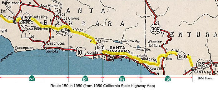 This route was originally signed as part of Route 150,
but in 1961 it was resigned as part of Route 154 (in fact, the Route 154
designation applied not only to current Route 154, but also to what became
Route 246 to Surf). Route 150 for some details of its history as Route 150.
This route was originally signed as part of Route 150,
but in 1961 it was resigned as part of Route 154 (in fact, the Route 154
designation applied not only to current Route 154, but also to what became
Route 246 to Surf). Route 150 for some details of its history as Route 150.
In 1861, a stagecoach route was built across San Marcos Pass by Chinese
workers working from both ends of the proposed course. The original
stagecoach route started near Kellogg Avenue in Goleta. Later, the route
began at the Arlington Hotel in downtown Santa Barbara. In 1892, a new
route was built on what is now called Old San Marcos Road. After crossing
the summit, the road went down to Cold Spring Tavern. The route continued
to the Santa Ynez Valley, going through Santa Ynez. At the corner of
Sagunto and Edison streets, the old College Hotel was located and was a
stage stop. The route headed north on Edison Street to Baseline Avenue to
the town of Ballard (the original stage station and the first town in the
Santa Ynez Valley.) The route then turned right on Alamo Pintado Road to
Mattei's Tavern and on to what is today Route 154 to US 101.
(Source: Lompoc Record, “Judith Dale: San Marcos Pass – A historic gateway to Santa Barbara County”, 4/28/2021)
When the stagecoach days were over, a roadway was built in place of the
old stagecoach road. Legend has it that the first automobile to go over
the Pass was in 1910. San Marcos Pass originally had 22 steep switchbacks.
With more modern machinery in the 1950s and '60s, a new route was built to
accommodate automobiles. When Bradbury Dam was built on the Santa Ynez
River in the early 1950s creating Lake Cachuma, the road had to be
changed, which shortened and straightened it.
(Source: Lompoc Record, “Judith Dale: San Marcos Pass – A historic gateway to Santa Barbara County”, 4/28/2021)
On AARoads, DT Composer noted: The original San Marcos Pass Road diverged
from today's Route 154 just south of the pass itself and went down today's
San Marcos Road into Goleta. The 1935 Santa Barbara County map shows this
as the state highway route from the pass south, then heading east on
today's Cathedral Oaks Road to join up with the current Route 192. San
Marcos Road between Cathedral Oaks and Hollister Avenue (US 101) is shown
as county road, with no state-maintained connections between then Route 150 and US 101 until today's Route 144 corridor. The current route from
the pass south into Santa Barbara was completed by 1938. He also noted
that the southernmost section of today's Route 154 was constructed as a
Super-2 in the 1960s, with several over/underpasses and a diamond
interchange at Cathedral Oaks Road/Foothill Boulevard (Route 192). The
ramps from Route 192 onto Route 154 even have the "Freeway Entrance"
signs, which aren't usually used in California for such short or
non-standard sections of freeway.
(Source: DTComposer on AARoads "Re: CA 150 family of highways; CA 246, CA 154, CA 192 and CA 150", 8/30/2019)
In 1961,CA 154 was first signed between Surf and US 101 in Santa Barbara.
This resulted in Route 150 being truncated to Route 154 just short of San
Marcos Pass in Santa Barbra. This change can be observed by comparing the
1961 State Highway Map to the 1962 Edition.
(Source: Gribblenation, "California State Route 150 family of highways (CA 246, CA 154, CA 192 and CA 150)", visited on 11/9/2019)
The Cold Spring Canyon Bridge made the Pass much safer. It eliminated a
steep, curvy and dangerous section of the road. Construction started in
1962. The bridge contains 5,094,000 pounds of steel and is as tall as a
36-story building. At its highest point, the bridge deck is 400 feet above
the canyon floor. It is the highest arch bridge in California and among
the highest in the U.S. The bridge is 1,217 feet long and opened for
traffic in February 1964.
(Source: Lompoc Record, “Judith Dale: San Marcos Pass – A historic gateway to Santa Barbara County”, 4/28/2021)
According to a photo supplied by Joel Windmiller, at some time between 1957 and 1964 it ran through Lompoc proper, cosigned with Route 1, along what is currently Route 246.
The portion of the route between Santa Barbara and Zaca (near Los Olivos) on US 101 [LRN 2] was LRN 80, defined in 1931. It was created as a state highway to provide relief for LRN 2 (US 101). By creating it, the state hoped that it would indefinitely postpone radical widening of the present state highway through Gaviota Canyon and along the coast, which would destroy valuable landscape and property.
The portion that became Route 246 was LRN 149, defined in 1933. This was originally signed as Route 150; in 1961, it was signed as part of Route 154. It is present-day Route 246 between Surf (10 mi W of Lompoc) and Route 154 near Santa Ynez.
 Status
Foxen Canyon Intersection (~ SB R2.384)
In September 2021, the SBCAG’s Highway 154 Safety
Committee held a meeting with representatives of the CHP, Caltrans
District 5 and Santa Barbara County Association of Governments and the
public, reporting on new and planned safety improvements on Route 154.
During the meeting, it was noted that a roundabout is planned sometime in
the future for the intersection of the highway with Foxen Canyon Road (~
SB R2.384), where the Santa Ynez Valley Traffic Circulation & Safety
Study recommended either that or a four-way stop.
(Source: Santa Maria Times, 10/8/2021)
In November 2023, it was reported that Caltrans was
holding public hearings regarding a proposal to implement improvements at
the intersection of Route 154 and Foxen Canyon Road in Los Olivos.
Caltrans considered current and future traffic volumes, collision data,
and other factors to identify feasible safety enhancements that would
address a pattern of collisions at the intersection and support safe and
efficient travel for all users now and into the future. The preliminary
evaluation indicates that a traffic signal or a roundabout would be
feasible alternatives at the intersection. Caltrans also found that
an all-way stop would not be operationally viable, causing significant
delays and potential safety concerns.
(Source: Santa Barbara Independent, 11/29/2023)
Alamo Pintado Pedestrian Bridge (05-SB-154 R2.6)
") The following project was included in the final adopted 2018 SHOPP in March 2018: PPNO 2391. 05-Santa Barbara-154 R2.6. Route 154 Near Los Olivos, at Alamo Pintado Pedestrian Bridge №
51-0076Y. Remove bridge. Begin Con: 10/6/2020. Total Project Cost:
$3,558K.
The following project was included in the final adopted 2018 SHOPP in March 2018: PPNO 2391. 05-Santa Barbara-154 R2.6. Route 154 Near Los Olivos, at Alamo Pintado Pedestrian Bridge №
51-0076Y. Remove bridge. Begin Con: 10/6/2020. Total Project Cost:
$3,558K.
In June 2018, removal of the Alamo Pintado Pedestrian
Bridge was delayed. The SHOPP amendment noted: Note: Delay PS&E as a
result of the State Historic Preservation Office’s determination
that the pedestrian bridge is historic and eligible for protection. Higher
level environmental document and additional time needed to complete
PA&ED.
(Source: CTC Agenda, June 2018 Agenda Item 2.1a(2)
Item 38)
In December 2018, the CTC approved the following SHOPP
amendment: 05-SB-154. R2.6. PPNO 2391. Project ID 0512000139. Route 154
Near Los Olivos, at Alamo Pintado Pedestrian Bridge № 51-0076Y. Remove
Replace bridge. As a result of the State Historic Preservation
Office’s determination that the pedestrian bridge is historic and
eligible for protection the bridge will be replaced rather than removed.
This will require additional funds for PS&E, right of way capital, and
construction support and capital. The replacement will also require
additional time for design resulting in a postponement of construction
year.
(Source: December 2018 CTC Minutes, Agenda Item
2.1a(1) Item 5)
In June 2019, the CTC approved the following SHOPP
scope amendment: 05-SB-154 R2.6 PPNO 2391. ProjID 0512000139. Route 154
Near Los Olivos, at Alamo Pintado Pedestrian Bridge № 51-0076Y.
Replace bridge. Project delivery is delayed one year since the project
scope was previously changed from remove bridge to replace bridge.
Completion extended to FY21-22.
(Source: June 2019 CTC Minutes, Agenda Item
2.1a.(1) Scope Item 69)
The 2020 SHOPP, approved in May 2020, included the
following Bridge Restoration item of interest (carried over from the 2018
SHOPP): 05-Santa Barbara-154 PM R2.6 PPNO 2391 Proj ID 0512000139 EA
1C410. Route 154 near Los Olivos, at Alamo Pintado Pedestrian Bridge
№ 51-0076Y. Replace bridge. Programmed in FY21-22, with construction
scheduled to start in September 2022. Total project cost is $8,335K, with
$3,660K being capital (const and right of way) and $4,675K being support
(engineering, environmental, etc.).
(Source: 2020 Approved SHOPP a/o May 2020)
In September 2020, it was reported that Caltrans was
holding public meetings on a proposal to remove the Alamo Pintado Creek
pedestrian bridge alongside Route 154 between Foxen Canyon Road and
Railway Avenue in Los Olivos. The deteriorating bridge has been closed for
some time due to safety concerns. Caltrans is considering alternatives for
the bridge that include removing and replacing it, removing the bridge
without replacing it, and leaving it as is.
(Source: Santa Maria Times, 9/9/2020)
In March 2021, the CTC approved for future
consideration of funding: 05-SB-154, PM R2.6. Alamo Pintado Creek
Pedestrian Bridge Project. Remove the pedestrian bridge over Alamo
Pintado Creek on Route 154 in Santa Barbara County. (MND) (PPNO 2391)
(SHOPP). This project is located in Santa Barbara County. The Department
proposes to remove and replace the Alamo Pintado Creek Pedestrian Bridge
at post mile R2.6 on the south side of Route 154 in the town of Los Olivos
in Santa Barbara County. The project would also remove a retaining wall
next to the bridge and install rock slope protection. The existing bridge
structure is 92 feet long by 28 feet wide and spans the Alamo Pintado
Creek. This project is currently programmed in the 2020 SHOPP for a total
of $8,335,000 which includes Construction (capital and support) and Right
of Way (capital and support). Construction is estimated to begin in
January 2023. The scope, as described for the preferred alternative, is
consistent with the project scope programmed by the Commission in the 2020
SHOPP. A Mitigated Negative Declaration (MND) has been completed.
The project will result in less than significant impacts to the
environment after mitigation. The following resource areas may be
impacted by the project: cultural resources. Avoidance and
minimization measures will reduce any potential effects on the
environment. These measures include, but are not limited to, creation of
an interpretive document (pamphlet/booklet) on the history of historic
Alamo Pintado Creek bridge for local repositories, professional
photographic and written recordation of the bridge, and installation of an
interpretive exhibit.
(Source: March 2021 CTC Agenda, Agenda Item
2.2c.(1))
Also in March 2021, the CTC approved the following
pre-construction SHOPP SB1 support phase allocation(s): (2b) #6.
$2,130,000 (PS&E; $2,050,000 programmed). 05-SB-154 R2.6. PPNO
05-2391; ProjID 0512000139; EA 1C410. Route 154 Near Los Olivos, at Alamo
Pintado Pedestrian Bridge № 51-0076Y. Replace bridge.
(Concurrent consideration of funding under Resolution E-21-21; March
2021.) (Nine month time extension for PS&E approved under Waiver
20-31; June 2020.) Prog. year 21-22.
(Source: March 2021 CTC Agenda, Agenda Item
2.5b.(2b) #6)
In May 2021, the CTC amended this project in the
SHOPP: (1d) #27. 05-SB-154 R2.6 PPNO 2391 ProjID 0512000139 EA
1C410. Route 154 Near Los Olivos, at Alamo Pintado Pedestrian Bridge
№ 51-0076Y. Replace bridge. Amended to update costs. Increase in
construction capital ($3,460K → $3,800K) is due to increases in
costs for structure removal, historical preservation work, and bird
netting. Increase in construction support ($1,450K → $1,810K) is due
additional work increasing working days from 135 to 150. Revised total:
$9,035K.
(Source: May 2021 CTC Agenda, Agenda Item 2.1a.(1d)
#27)
In October 2022, the CTC approved the following SHOPP
amendment: #22. 05-SB-154 R2.6. PPNO 05-2391; ProjID 0512000139; EA
1C410. Route 154 Near Los Olivos, at Alamo Pintado Pedestrian Bridge
№ 51-0076Y. Replace bridge. Allocation Changes ($ × 1,000):
Const Cap: $3,800 ⇨ $3,665; Total $9,035 ⇨ $8,900. Note: Split
biological monitoring work into project EA 1C410/PPNO 05-2391X from parent
project EA 1C410/PPNO 05-2391.
(Source: October 2022 CTC Agenda, Agenda Item
2.1a.(1d) #22)
In October 2022, the CTC approved the following
construction phase allocation: $6,117,000. 05-SB-154 R2.6. PPNO 05-2391;
ProjID 0512000139; EA 1C410. Route 154 Near Los Olivos, at Alamo Pintado
Pedestrian Bridge № 51-0076Y. Outcome/Output: Replace bridge
to restore structural integrity. Programmed allocation: CON ENG
$1,810,000; CONST $3,665,000. CEQA - MND, 1/21/2021; Re-validation
5/31/2022. NEPA - CE, 1/14/2021; Re-validation 5/31/2022. Future
consideration of funding approved under Resolution E-21-21; March 2021.
Nine month time extension for CONST and CON ENG approved under Waiver
22-73; June 2022. Concurrent Amendment under SHOPP Amendment 22H-004;
October 2022.
(Source: October 2022 CTC Agenda, Agenda Item
2.5b.(1) #10)
In May 2023, it was reported that the project to
replace the Alamo Pintado Creek pedestrian bridge on the south side of
Route 154 near Los Olivos would begin construction the week of Monday, May
22, 2023. The project to remove a retaining wall adjacent to the bridge
and install rock slope protection is estimated for completion by summer
2025. During construction officials said the bridge will be closed to all
pedestrians, equestrians and bicyclists will need to use Route 154 or a
local street to cross the creek. The bridge was constructed in 1912, and
in 1971, a new bridge structure, Alamo Pintado Creek Bridge, was built on
a new alignment 40 feet upstream from the original structure.
(Source: Santa Maria Times, 5/16/2023)
In September 2021, the SBCAG’s Highway 154 Safety Committee held a
meeting with representatives of the CHP, Caltrans District 5 and Santa
Barbara County Association of Governments and the public, reporting on new
and planned safety improvements on Route 154. During the meeting, it was
noted that a roundabout is planned sometime in the future at Route 154 and
Grand Avenue in Los Olivos (~ SB R2.838), where the Santa Ynez Valley
Traffic Circulation & Safety Study recommended either that or a
four-way stop.
(Source: Santa Maria Times, 10/8/2021)
In July 2009, the CTC approved vacation of right of way in the county of Santa Barbara along Route 154 on Railway Avenue in Los Olivos (~ SB R2.914), consisting of highway right of way no longer needed for State highway purposes.
In September 2021, the SBCAG’s Highway 154 Safety Committee held a
meeting with representatives of the CHP, Caltrans District 5 and Santa
Barbara County Association of Governments and the public, reporting on new
and planned safety improvements on Route 154. One of these improvements
were new signs advising to "Watch for entering vehicles" and "Look
left-right-left before pulling out" at the intersection with Roblar Avenue
(~ SB R4.507). The signs are experimental, and Caltrans is continuing to
evaluate this sign for its efficacy at reducing collisions associated with
people not seeing the cars approaching broadside. The intersection has a
collision rate "over twice the statewide average for similar
intersections," according to a Caltrans memo from March 2020 to test the
signs, which are used in Pennsylvania. The signs were in response to
community comments. These are very unsual sign, not in use anywhere else
in California. There may also be a roundabout added to the intersection.
(Source: SB Noozhawk, 10/1/12021)
Edison Street/Baseline Avenue Roundabout (05-SB-154 R5.8/R6.1)
The following project was included in the final adopted 2018 SHOPP in March 2018: PPNO 2674. 05-Santa Barbara-154 R5.8/R6.1. Route 154 In Santa Ynez, from 0.2 mile east to 0.1 mile west of Edison Street/Baseline Avenue. Construct a roundabout to improve operations and safety. Begin Con: 7/22/2022. Total Project Cost: $11,980K.
In January 2020, the CTC approved the following
pre-construction allocation: 05-SB-154 R5.8/R6.1. ProjID 0516000060. PPNO
2674. EA 1H310. Route 154 in Santa Ynez, from 0.2 mile east to 0.1 mile
west of Edison Street/Baseline Avenue. Construct a roundabout to improve
operations and safety. Allocation: PS&E $1,440,000 R/W Sup
$418,000
(Source: January 2020 CTC Agenda, Agenda Item
2.5b.(2a) #15)
The 2020 SHOPP, approved in May 2020, included the
following Mobility item of interest (carried over from the 2018 SHOPP):
05-Santa Barbara-154 PM R5.8/R6.1 PPNO 2674 Proj ID 0516000060 EA 1H310.
Route 154 in Santa Ynez, from 0.2 mile east to 0.1 mile west of Edison
Street/Baseline Avenue. Construct a roundabout to improve operations and
safety. Programmed in FY21-22, with construction scheduled to start in
July 2022. Total project cost is $11,980K, with $7,715K being capital
(const and right of way) and $4,265K being support (engineering,
environmental, etc.).
(Source: 2020 Approved SHOPP a/o May 2020)
In June 2021, the CTC approved the following amendment
to the 2020 SHOPP: 05-SB-154 R5.8/R6.1 PPNO 2674 ProjID 0516000060 EA
05-1H310. Route 154 In Santa Ynez, from 0.2 mile east to 0.1 mile west of
Edison Street/Baseline Avenue. Construct a roundabout to improve
operations and safety. Note: Decrease R/W capital because a redesign of
the roundabout location has reduced utility relocation and land
acquisition requirements. R/W Cap $888K $188K;
Total $11,980K $11,280K.
(Source: June 2021 CTC Agenda, Agenda Item
2.1a.(1d) #32)
In September 2021, the SBCAG’s Highway 154 Safety
Committee held a meeting with representatives of the CHP, Caltrans
District 5 and Santa Barbara County Association of Governments and the
public, reporting on new and planned safety improvements on Route 154. One
of these improvements was the Baseline-Edison roundabout, which is where
Baseline Avenue and Edison Street meet head-on, creating a “T”
to intersect with Route 154. Studies show roundabouts reduce injury
collisions by 76%, with a 31% reduction in overall crashes. The CHP notes
that Route 154 takes up over 5% of the crashes that occur in the Santa
Barbara and Buellton area. A total of 365 crashes were reported on Route 154 between 2019 and 2021, with 137 occurring in 2019, 119 in 2020 and 109
so far in 2021, according to statistics provided by the CHP. Crashes
resulting in injuries totaled 51 in 2019, 49 in 2020 and 36 thus far in
2021. Two crashes resulted in one death each in 2019, four crashes with
one death each were reported in 2020 and two crashes led to one death each
so far in 2021. Crashes involving DUI drivers totaled 12 with one fatality
in 2019, five with three fatalities in 2020 and three with one fatality so
far in 2021.
(Source: Santa Maria Times, 10/8/2021)
In August 2023, the CTC amended the 2022 SHOPP
regarding the following project: 05-SB-154 R5.8/R6.1 R5.7/R6.2.
PPNO 05-2674; ProjID 0516000060; EA 1H310. Route 154 In Santa Ynez, from 0.2
0.3 mile east to 0.1 0.2 mile west of
Edison Street/Baseline Avenue. Construct a roundabout to improve
operations and safety. Note: Update project description and postmile.
Split planting and plant establishment into project EA 1H311/PPNO 05-2674Y
from parent project EA 1H310/PPNO 05-2674. Allocation changes ($ ×
1,000): Const Cap $6,827 $5,527; TOTAL $11,280
$9,980.
(Source: August 2023 CTC Agenda, Agenda Item 2.2a.(1d) #8)
In August 2023, the CTC approved an allocation request
for $11,425,000 for the SHOPP Operational Improvements project on Route 154, in Santa Barbara County, to advertise the project. This project
(05-SB-154 R5.7/R6.2, PPNO 05-2674, ProjID 0516000060, EA 1H310) is
located on Route 154, in the Town of Santa Ynez, at the Edison Street and
Baseline Avenue intersection, in Santa Barbara County. The project
will convert an existing intersection to a roundabout. In March 2018, this
project was programmed in the SHOPP for $6,827,000 in Construction Capital
and $1,614,000 in Construction Support for allocation in Fiscal Year
2021-22. In June 2022, the project received a 12-month allocation
time extension for the Construction phase. In June 2023, the project
received an amendment to the time extension for an additional 7-months to
allocate the Construction phase. In June 2023, the Engineer’s
Estimate (EE) reflected the need of $9,625,000 in Construction Capital
(41.0 percent over the original programmed amount) and $1,800,000 in
Construction Support (11.5 percent over the programmed amount). The
Department plans to advertise the project in September 2023, award in
November 2023, and begin construction in January 2024. Construction is
planned for one construction season with a duration of 200 working days. A
concurrent amendment, on this month’s agenda, to split funding for a
child landscape project (PPNO 2674Y/EA 1H311) for $1,300,000 in
Construction Capital. After the approval of the amended programmed amount,
the need in Construction Capital will amount to 74.1 percent over the
revised programmed amount. The Construction Capital estimate is greater
than the programmed amount due to revisions to some of the drainage
systems, design of a detour to improve constructability of the roundabout,
additional traffic control features to improve safety during construction,
and a revised landscaping plan to offset urban visual impacts. The
Construction Support estimate is greater than the programmed amount due to
an increase in working days. Preliminary Engineering (Budget / Expended):
PA&ED $793,000 / $504,449; PS&E $1,440,000 / $1,382,336;
R/W Sup $418,000 / $316,111. Allocation (Programmed / Allocated):
CON ENG $1,614,000 / $1,800,000; CONST $5,527,000 / $9,625,000.
(Source: August 2023 CTC Agenda, Agenda Item 2.5d.(4))
In August 2011, an editorial indicated that Caltrans is exploring a roundabout at the intersection of Route 246 and Route 154 (~ SB R8.174). As of June 2016, that roundabout had been installed.
In February 2012, it was reported that the Alisal Bridge, which runs on Route 154 over the Santa Ynez River (Bridge № 51-0079, SB R010.12, built in 1971) was determined by Caltrans after a recent inspection to be “structurally deficient,” with cracks and poor structural integrity, according to Solvang Public Works Director Matt van der Linden. The report estimated that the bridge, built in 1972, has about 10 years of viability remaining and recommended a seismic retrofit to reinforce the current structure before replacement. The concerns about the bridge led the Solvang City Council to shift its focus to replacing the Alisal Bridge and delay the improvement and widening project scheduled for the span on Route 246 near Alamo Pintado Road (Bridge 51-0130, SB 030.32, built in 1954, widened in 1972). The cost for replacing the 850-foot Alisal Bridge would be about $19.5 million, according to van der Linden, but it must have the seismic retrofit – a process that reinforces concrete and cabling – before it can receive federal funds. Van der Linden said that grant funding, if authorized by Caltrans, would be available to cover “approximately 88.5% of design and environmental processing costs, and 100% of the construction costs” of the estimated $650,000 retrofit, leaving Solvang on the hook for around $30,000.
Route 154 Sinkhole
In January 2019, storms inflicted major damage on Route 154 E of Cachuma Lake, when a portion of the roadway was washed away
during heavy rain which caused downed trees and roadway flooding
throughout Santa Barbara County. A spokesman with Caltrans said a blocked
culvert resulted in water running along the surface and that motorists
should use US 101 as a detour.
(Source: Lompoc Record, 2/4/2019)
In March 2019, it was reported that Route 154 had
reopened. The highway that connects Santa Barbara to the Santa Ynez Valley
has been closed since February 2 after heavy rain storms. A culvert near
Cachuma Lake was clogged with debris, mud and burnt trees from the
Whittier fire following those storms. That caused flooding and damaged the
roadway. Caltrans and CalPortland crews had been working around the clock
to clear the drainage culvert and reopen the highway. Crews were able to
get a special striping material to stick and stay here faster than other
projects that enabled the damaged section of Route 154 to open sooner than
scheduled.
(Source: KEYT News, 3/1/2019)
In June 2016, it was reported that residents along Route 154 were
increasingly concerned about the number of near misses on the highway.
Near-misses and fatal crashes have spurred Santa Ynez Valley residents to
lobbying for the changes to make the road safer. Increased traffic along
Route 154 is blamed on a number of factors, including tourism, the Chumash
Casino, wine tasting, and local commuters. But the road safety advocates
also contend online mapping systems calling Route 154 a shorter route
between northern and southern Santa Barbara County add to the traffic
—and dangers. Websites label the highway as a scenic back road and a
shorter distance than taking US 101. It was noted that there’s one
big factor the state transportation engineers can’t fix —
motorists who drive while intoxicated, distracted, sleepy or otherwise
impaired.
(Source: Noozhawk, 6/16/2016)
Cold Springs Suicide Barrier (~ SB 022.96)
![[Cold Springs]](maps/154-coldsprings.jpg) There are some initiatives to make changes to the 1,200 ft long Cold Springs
Arch Bridge, which was constructed between June 1962 and 1964, and
seismically retrofitted in 1998. The bridge opened in 1964. There have
been numerous jumpers from the bridge, which is a 220-foot fall into a
wooded ravine, always lethal. As of February 2008, there had been 44
suicides, including a 60-year-old doctor that left his car running and
jumped over the thigh-high railing. In the Summer of 2007, Caltrans came
up with a $1-million plan to install 6-foot-high safety barriers on top of
the existing 30-inch-high concrete railing. The project has the backing of
the Sheriff's Department, the California Highway Patrol and mental health
experts. But some bridge supporters decry the barriers, saying they will
spoil the view from the bridge, and that they won't work. In May 2008, the
CTC looked at the announcment of the preparation of an EIR, which proposed
3 alternatives: (1) No Build; (2) Construct continuous metal barrier with
inward sloping vertical steel rod pickets. (3) Construct continuous metal
barrier with inward sloping grid/mesh steel wire pickets. In June 2008,
the Draft EIR was on the CTC agenda. It noted the project is fully
programmed in the 2008 State Highway and Operation Protection Program
(SHOPP) for $3,183,000, capital and support. Construction is estimated to
begin in Fiscal Year 2009-10. According to USA Today, at least 49 people
have leaped to their death from the Cold Spring bridge as of October 2009,
five in 2009 alone. In October 2009, a 59-year-old woman used two canes
and a foot stool to get over the bridge. However, not all favor the
bridge. A group calling itself Friends of the Bridge filed suit in July
2009 to stop the barrier, which "threatens to deface the most beautiful
long-span steel arch bridge in America," Marc McGinnes, a retired
environment professor at the University of California-Santa Barbara and
head of the group, said in an e-mail. Rather than prevent suicides, he
said, a barrier would "merely divert occasional suicides from the bridge
to other places in the community."
There are some initiatives to make changes to the 1,200 ft long Cold Springs
Arch Bridge, which was constructed between June 1962 and 1964, and
seismically retrofitted in 1998. The bridge opened in 1964. There have
been numerous jumpers from the bridge, which is a 220-foot fall into a
wooded ravine, always lethal. As of February 2008, there had been 44
suicides, including a 60-year-old doctor that left his car running and
jumped over the thigh-high railing. In the Summer of 2007, Caltrans came
up with a $1-million plan to install 6-foot-high safety barriers on top of
the existing 30-inch-high concrete railing. The project has the backing of
the Sheriff's Department, the California Highway Patrol and mental health
experts. But some bridge supporters decry the barriers, saying they will
spoil the view from the bridge, and that they won't work. In May 2008, the
CTC looked at the announcment of the preparation of an EIR, which proposed
3 alternatives: (1) No Build; (2) Construct continuous metal barrier with
inward sloping vertical steel rod pickets. (3) Construct continuous metal
barrier with inward sloping grid/mesh steel wire pickets. In June 2008,
the Draft EIR was on the CTC agenda. It noted the project is fully
programmed in the 2008 State Highway and Operation Protection Program
(SHOPP) for $3,183,000, capital and support. Construction is estimated to
begin in Fiscal Year 2009-10. According to USA Today, at least 49 people
have leaped to their death from the Cold Spring bridge as of October 2009,
five in 2009 alone. In October 2009, a 59-year-old woman used two canes
and a foot stool to get over the bridge. However, not all favor the
bridge. A group calling itself Friends of the Bridge filed suit in July
2009 to stop the barrier, which "threatens to deface the most beautiful
long-span steel arch bridge in America," Marc McGinnes, a retired
environment professor at the University of California-Santa Barbara and
head of the group, said in an e-mail. Rather than prevent suicides, he
said, a barrier would "merely divert occasional suicides from the bridge
to other places in the community."
(Source: Los Angeles Times, USA Today; Image source: AARoads)
In January 2012, construction resumed on the grid-mesh barrier being installed on both sides of the Cold Spring Arch Bridge. Construction had been stalled by court challenges, but a judge ruled in summer 2011 in favor of Caltrans resuming the $778,000 project. As of January 2012, the bridge had been the site of 55 suicides, according to Caltrans.
In September 2012, it was reported that the newly installed suicide barrier was... ineffective. Just six months after completion, a 30-year old man allegedly foiled the multi-million dollar cage and jumped to his death. That suicide marks the 55th time a person has jumped to his/her death since the bridge opened in in 1964 (hmmm, if the article was correct, it would have been the 56th time)
In March 2021, it was reported that Cold Spring Bridge (~ SB 022.96) on
Route 154 was receiving some external upgrades as part of a Caltrans
project to clean, inspect and repaint the bridge. The maintenance project,
which began in March 2021, will complete necessary inspections and give
the bridge a fresh coating of green paint for the first time in 50 years.
In addition, the project will add a catwalk underneath the structure to
allow easier access for crews to perform future inspections. The $7
million project is expected to be finished by the spring of 2023, and is
being conducted by Certified Coatings of Fairfield.
(Source: Santa Barbara News Press, 3/18/2021)
The SAFETEA-LU act, enacted in August 2005 as the reauthorization of TEA-21, provided the following expenditures on or near this route:
 Naming
This has historically been named the "San Marcos Pass Road" from Los Olivos to Route 101 near Santa Barbara.
Historically, this route has also been named "El Camino Cielo" (The Road to the Sky).
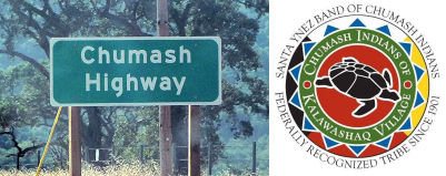 Designated in its entirety as the "Chumash Highway". This segment was named in
honor of the Chumas Indian tribe. In prehistoric times, the Chumash
territory encompassed some 7,000 square miles, and today, this same region
in southern central California takes in five counties, including Santa
Barbara, Ventura, San Luis Obispo, Los Angeles, and Kern. While some place
names in this geographic region reflect their Chumash language origins,
the trails and routes that connected them remain unrecognized as the
forerunners of today's highways. Route 154 follows an elaborate Chumash
trail network, which linked several hundred early Chumash villages and
towns, seasonal encampments, rock art sites, shrines, gathering places,
and water sources, and these trails were vital to sustaining cultural
longevity for over 8,000 years in this region as they formed the
foundation for economic and social exchange among the Chumash. In historic
times, routes through the Chumash territory were first recorded in the
diaries of the Gaspar de Portola Expedition in 1769, in which it is noted
that in many instances Chumash Indians led members of the expedition from
one village to another, showing them the trails. Many notable works
subsequently validate the location of the Chumash trail system, including
along present-day Route 154. Numerous archaeological sites along Route 154
further support the historical significance of the area and the trails to
the Chumash. Named by Assembly Concurrent Resolution (ACR) 75, Resolution
Chapter 149, on October 2, 2007.
Designated in its entirety as the "Chumash Highway". This segment was named in
honor of the Chumas Indian tribe. In prehistoric times, the Chumash
territory encompassed some 7,000 square miles, and today, this same region
in southern central California takes in five counties, including Santa
Barbara, Ventura, San Luis Obispo, Los Angeles, and Kern. While some place
names in this geographic region reflect their Chumash language origins,
the trails and routes that connected them remain unrecognized as the
forerunners of today's highways. Route 154 follows an elaborate Chumash
trail network, which linked several hundred early Chumash villages and
towns, seasonal encampments, rock art sites, shrines, gathering places,
and water sources, and these trails were vital to sustaining cultural
longevity for over 8,000 years in this region as they formed the
foundation for economic and social exchange among the Chumash. In historic
times, routes through the Chumash territory were first recorded in the
diaries of the Gaspar de Portola Expedition in 1769, in which it is noted
that in many instances Chumash Indians led members of the expedition from
one village to another, showing them the trails. Many notable works
subsequently validate the location of the Chumash trail system, including
along present-day Route 154. Numerous archaeological sites along Route 154
further support the historical significance of the area and the trails to
the Chumash. Named by Assembly Concurrent Resolution (ACR) 75, Resolution
Chapter 149, on October 2, 2007.
(Image source: Flikr, Santa Ynez Chumash Pow-wow FB Page)
 The intersection of Route 154 and Rout 246 in Santa Barbara County (~ SB R8.174) is named the "Senior
Investigator Laura Jean Cleaves Memorial Junction". It was named in
memory of Laura Jean Cleaves, born on April 19, 1955, in Long Beach,
California. In 1976, Ms. Cleaves joined the Los Angeles County Sheriff's
Department, where she met her future husband, Deputy Stephen M. Cleaves,
and they were married in 1978 and moved to northern California two years
later, where she distinguished herself as the first female police officer
for the City of Arcata. Relocating to Santa Barbara County in 1981, Ms.
Cleaves accepted a position with the Santa Barbara Police Department and,
in 1984, became an investigator with the Santa Barbara County District
Attorney's Office where she excelled as a criminal investigator and was
later promoted to senior investigator. She continually demonstrated
honesty, integrity, professionalism, and leadership in all her varied
assignments. An avid and accomplished horsewoman, Ms. Cleaves wrote
articles on horse care, safety, and riding and provided riding instruction
for those with a love of horses and, in 1988, she began sharing her
expertise as a reserve deputy sheriff and instructor for the Sheriff's
Mounted Unit. Ms. Cleaves had a passion for protecting others, and while
on duty April 30, 2008, her vehicle was struck by a drunken driver and she
suffered a fatal injury. Named by Assembly Concurrent Resolution (ACR)
147, Resolution Chapter 161, on 9/19/2008.
The intersection of Route 154 and Rout 246 in Santa Barbara County (~ SB R8.174) is named the "Senior
Investigator Laura Jean Cleaves Memorial Junction". It was named in
memory of Laura Jean Cleaves, born on April 19, 1955, in Long Beach,
California. In 1976, Ms. Cleaves joined the Los Angeles County Sheriff's
Department, where she met her future husband, Deputy Stephen M. Cleaves,
and they were married in 1978 and moved to northern California two years
later, where she distinguished herself as the first female police officer
for the City of Arcata. Relocating to Santa Barbara County in 1981, Ms.
Cleaves accepted a position with the Santa Barbara Police Department and,
in 1984, became an investigator with the Santa Barbara County District
Attorney's Office where she excelled as a criminal investigator and was
later promoted to senior investigator. She continually demonstrated
honesty, integrity, professionalism, and leadership in all her varied
assignments. An avid and accomplished horsewoman, Ms. Cleaves wrote
articles on horse care, safety, and riding and provided riding instruction
for those with a love of horses and, in 1988, she began sharing her
expertise as a reserve deputy sheriff and instructor for the Sheriff's
Mounted Unit. Ms. Cleaves had a passion for protecting others, and while
on duty April 30, 2008, her vehicle was struck by a drunken driver and she
suffered a fatal injury. Named by Assembly Concurrent Resolution (ACR)
147, Resolution Chapter 161, on 9/19/2008.
(Image source: Officer Down Memorial Page)
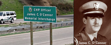 The interchange of Route 154 and US 101, in the County of Santa Barbara (~ SB R32.205) is
named the "CHP Officer James C. O’Connor Memorial Interchange".
It was named in memory of Officer James Christopher O’Connor, who
was born on July 9, 1956. On December 23, 1982, Officer James Christopher
O’Connor, graduated from the California Highway Patrol Academy and
was assigned to the West Valley area. He completed motorcycle training on
February 28, 1985, and was transferred to the Ventura area, where he spent
the remainder of his career. Officer O’Connor was killed in the line
of duty on November 15, 1990, at approximately 1524 hours. He and three
fellow motor officers were traveling home from a divisionwide motorcycle
training day in Santa Maria. A 1986 Ford Thunderbird, driven by a
78-year-old driver, failed to turn her vehicle at a curve and crossed over
the center line into the group of officers. Officer O’Connor was
struck head-on and thrown approximately 60 feet. During the impact, he was
knocked out of his helmet and boots. Officer O’Connor’s fellow
officers called for help and immediately began cardiopulmonary
resuscitation (CPR). He was transported to a nearby hospital, but
succumbed to his injuries. Officer O’Connor was a good man and a
good officer. He was known for his skill in riding motorcycles and his
ability to get into accidents when driving an automobile. One day, while
on patrol, Officer O’Connor managed to crash his patrol car into the
center divider at approximately 75 mph while trying to split traffic. It
was named in recognition of Officer James Christopher
O’Connor’s contributions and sacrifice in serving the
Department of the California Highway Patrol and the citizens of
California.Named by Assembly Concurrent Resolution 100, Resolution Chapter
109, on September 4, 2012.
The interchange of Route 154 and US 101, in the County of Santa Barbara (~ SB R32.205) is
named the "CHP Officer James C. O’Connor Memorial Interchange".
It was named in memory of Officer James Christopher O’Connor, who
was born on July 9, 1956. On December 23, 1982, Officer James Christopher
O’Connor, graduated from the California Highway Patrol Academy and
was assigned to the West Valley area. He completed motorcycle training on
February 28, 1985, and was transferred to the Ventura area, where he spent
the remainder of his career. Officer O’Connor was killed in the line
of duty on November 15, 1990, at approximately 1524 hours. He and three
fellow motor officers were traveling home from a divisionwide motorcycle
training day in Santa Maria. A 1986 Ford Thunderbird, driven by a
78-year-old driver, failed to turn her vehicle at a curve and crossed over
the center line into the group of officers. Officer O’Connor was
struck head-on and thrown approximately 60 feet. During the impact, he was
knocked out of his helmet and boots. Officer O’Connor’s fellow
officers called for help and immediately began cardiopulmonary
resuscitation (CPR). He was transported to a nearby hospital, but
succumbed to his injuries. Officer O’Connor was a good man and a
good officer. He was known for his skill in riding motorcycles and his
ability to get into accidents when driving an automobile. One day, while
on patrol, Officer O’Connor managed to crash his patrol car into the
center divider at approximately 75 mph while trying to split traffic. It
was named in recognition of Officer James Christopher
O’Connor’s contributions and sacrifice in serving the
Department of the California Highway Patrol and the citizens of
California.Named by Assembly Concurrent Resolution 100, Resolution Chapter
109, on September 4, 2012.
(Image sources: Frank B. Baiamonte Blog, California Assn of Highway Patrolmen)
 Freeway
[SHC 253.1] Entire route. Added to the Freeway and Expressway system in 1959.
Note: A section of freeway exists in Santa Barbara for about 2 miles.
 Scenic Route
[SHC 263.1] Entire route.
 Classified Landcaped Freeway
The following segments are designated as Classified Landscaped Freeway:
| County | Route | Starting PM | Ending PM |
| Santa Barbara | 154 | R31.48 | R32.20 |
 Interregional Route
[SHC 164.17] Entire route.
 Other WWW Links
 Statistics
Overall statistics for Route 154:
 Pre-1964 Legislative Route
In 1933, Chapter 767 defined the routes from "[LRN 2] near El Rio to Montalvo-San Fernando Road near Saticoy" and from "The Montalvo-San Fernando Road near Saticoy to [LRN 79]" as part of the state highway system. In 1935, LRN 154 was added to the highway code with the following routing:
In 1951, Chapter 1562 added the segment from LRN 60 to LRN 2 as a new segment (a): "(a) The junction of [LRN 60] and Saviers Road in Ventura County, along the route of said road to [LRN 2] near El Rio."
In 1957, Chapter 1911 removed the portion of the routing north of [LRN 9] (Route 118), simplified the origin, and eliminated the discontinity: "[LRN 60] near El Rio to [LRN 9] near Saticoy."
This route (Route 1 to Route 118) is present-day Route 232. It appears to have been signed as a spur of Sign Route 126 before 1964 along Vineyard and Saviers.
© 1996-2020 Daniel P. Faigin.
Maintained by: Daniel P. Faigin
<webmaster@cahighways.org>.
 om Route
  Route 153
 Route 155