
 California Highways:
Click here for a key to the symbols used. An explanation of acronyms may be found at the bottom of the page.
 Routing
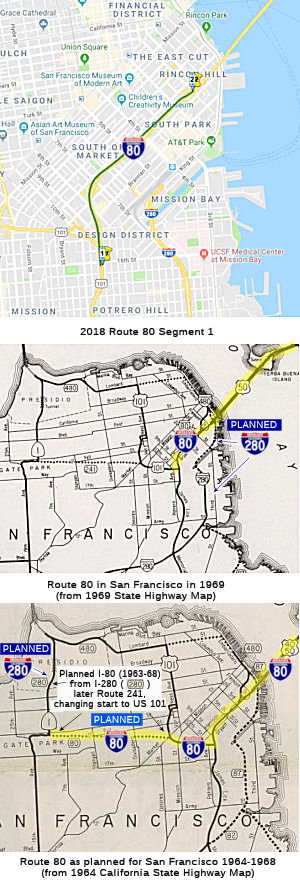
 From Route 101 near Division Street in San Francisco to Route 280 near
First Street in San Francisco.
From Route 101 near Division Street in San Francisco to Route 280 near
First Street in San Francisco.
 Interstate Submissions
Approved as chargeable Interstate on 7/7/1947; deleted as chargeable interstate in August 1965.
 Post 1964 Signage History
As defined in 1963, Route 80 was defined to run from "Route 280 in San Francisco to the Nevada state line near Verdi, Nevada, passing near Division Street in San Francisco, passing near Oakland, via Albany, via Sacramento, passing near North Sacramento, passing near Roseville, via Auburn, via Emigrant Gap, via Truckee and via the Truckee River Canyon." Note that the Route 280 in that definition is present-day Route 1.
In 1968, Chapter 282 transferred the portion from I-280 (present-day Route 1) to US 101 (LRN 223) to Route 241. This was originally part of a much longer route, and would have formed the handle of the "Panhandle" Freeway. Additional history on the planned freeways for the San Francisco Bay area can be found here. This ended up splitting the definition of Route 80, giving the current segment. Note that, technically, this segment is not part of the interstate system; it is unclear how it is signed.
According to Sean Tongson, there is further evidence of the planned I-80 extension onto the Central Freeway into Golden Gate Park. The mileposts at the termination of I-80 at US-101 read '4.05'. This indicates that further extension definitely was in mind, with the additional 4 miles accounting for the unconstructed segment going into Golden Gate Park. The mileposts at the junction with former Route 480/I-280 read '5.09'.
Hoodline provides a good summary of the history of the Panhandle Freeway. The following is excerpted from that page: The Panhandle Freeway started with the existing road through the Panhandle called Avenue Drive. Oak and Fell were two-way streets on the sides. The California Department of Highways (now called Caltrans) and city planners envisioned a grand plan bringing the Central Freeway through Hayes Valley, semi-submerging it into the Panhandle, then curving into Golden Gate Park, passing underneath the Main Drive (what is now called John F. Kennedy Drive) and connecting with US 101 at 14th and Fulton. It was to be called the Panhandle Freeway. In 1945, the newly formed San Francisco Planning Commission adopted a ‘Master Plan’ that included designs for major thoroughfares along Bayshore, Embarcadero and the Panhandle. The first leg, the replacement of the Bayshore Highway system with a safer freeway, began in 1950 and was completed in 1958. When planners proposed an elevated “Western Freeway” along 19th Avenue in 1956, it was rejected by the Board of Supervisors in an 8-3 vote, led by William Blake. The double-deck Embarcadero freeway was opened 1958 and the elevated Central Freeway was opened the next year, bringing a freeway to Hayes Valley. In 1960, the Division of Highways and the Planning Commission renewed their calls for freeways running through the city, but instead they proposed depressed freeways or tunneled freeways through the Panhandle and 19th Ave. By 1962, both of these proposals were rejected by the Board of Supervisors, albeit by a smaller 6-5 margin. Supervisor William Blake instead proposed building a tunnel underneath Pacific Heights, towards the Golden Gate Bridge, thus eliminating the need for freeways on top of the city. As other efforts stalled, freeway advocates pushed forward with the Panhandle as the main artery to connect northwest San Francisco and the Golden Gate Bridge to the rest of the peninsula. Tthe City Recreation and Parks commission unanimously approved the Panhandle proposal on July 10th 1964, despite a large protest. Following this result, the Division of Highways renewed calls for studies into freeway proposals in March of 1965. One main factor that you can find in newspaper article of the era was that San Francisco had been earmarked $250 million ($1.86 billion in 2015 dollars) in Federal Interstate Highway Funds. This would be lost, Senator J. Eugene McAteer warned, if the city decided not to go forward with the proposals. Beyond the park’s destruction, between 415 and 500 people were to be removed from their homes and relocated away from the Panhandle corridor. The city had been busy bulldozing large swathes of Western Addition since the 40s in the name of urban renewal, and combined with the divisive effects of the Bayshore Freeway, many citizens were losing their appetite for sacrificing neighborhoods for grand civic projects. One lesser-known part of the Panhandle plan is that it was envisioned as a complement to the would-be recreated version of Western Addition. The Citizens Committee to Save Golden Gate Park (CCTSGGP) coalesced 26 civic groups in opposition to the freeway. This group organized a protest in May 17, 1964 at the Polo Grounds where folk singer Malvina Reynolds sang a song composed for the occasion, called the "Cement Octopus". The denouement of the struggle came on March 21, 1966, when the Board of Supervisors voted, 6-5, to reject both the Panhandle and the complementary Golden Gate Freeway. A plaque now stands in a grove at the western end of the Panhandle commemorating the vote.
Before 1968, maps indicate that I-80 was routed on the Central Freeway, and was cosigned with US 101 up to Fell Street (which corresponds to the constructed portion shown on the 1964 State Highway Map).
 Pre 1964 Signage History
 This segment was originally cosigned as US 40/US 50, dating
back to the signage of US highways. It was LRN 68, defined in 1923.
This segment was originally cosigned as US 40/US 50, dating
back to the signage of US highways. It was LRN 68, defined in 1923.
Note: For more information, see the section of the Route 40 page on US 40. Similarly, see the page on Route 40 (US 40 Sections) for information on freeway adoptions along the route.
This segment was part of the Lincoln Highway, which originally terminated in Lincoln Park, six miles west of the ferry landing at the foot of Market Street. The Lincoln Highway ended opposite the Palace of the Legion of Honor at a small monument marking the spot. The last few miles (of the highway) were California Street.
Note: The discussion of US 80 is generally from East (Yuma AZ) to West (San Diego, CA), as opposed to the normal postmile direction of West to East.
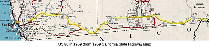
 Before the 1964 signage/legislative route alignment, signed route 80 was US 80, which roughly followed the route of
the current I-8. US 80 was defined as part of the original set of US routes in 1926, running from Yuma AZ through El Centro to San Diego. It
was first signed in 1928, with a routing defined to begin at San Diego to
Jacumba, to the Arizona-California state line W of Yuma AZ via El Centro.
The actual routing for US 80 began in California near Winterhaven at the
Arizona State line, and continued W through Midway Wellls, Holtville, El
Centro, Seeley, Dixieland, Plaster City, Jacumba, Boulevard, Paposta, Pine
Valley, Guatay, Descanso, El Cajon, and into San Diego. This was LRN 12
(defined in 1909) between San Diego and El Centro, and LRN 27 (defined in
1915) between El Centro and Winterhaven. In San Diego, US 80 followed El
Cajon and University to 4th Street, then went south on 4th
Street to San Diego and US 101.
Before the 1964 signage/legislative route alignment, signed route 80 was US 80, which roughly followed the route of
the current I-8. US 80 was defined as part of the original set of US routes in 1926, running from Yuma AZ through El Centro to San Diego. It
was first signed in 1928, with a routing defined to begin at San Diego to
Jacumba, to the Arizona-California state line W of Yuma AZ via El Centro.
The actual routing for US 80 began in California near Winterhaven at the
Arizona State line, and continued W through Midway Wellls, Holtville, El
Centro, Seeley, Dixieland, Plaster City, Jacumba, Boulevard, Paposta, Pine
Valley, Guatay, Descanso, El Cajon, and into San Diego. This was LRN 12
(defined in 1909) between San Diego and El Centro, and LRN 27 (defined in
1915) between El Centro and Winterhaven. In San Diego, US 80 followed El
Cajon and University to 4th Street, then went south on 4th
Street to San Diego and US 101.
 Note that there is a County Sign Route S80 near El Centro; this is likely a former
routing of US 80.
Note that there is a County Sign Route S80 near El Centro; this is likely a former
routing of US 80.
The Algodones Dunes Old Plank Road
 There is a plank road just off of the old US 80 routing;
this it appears to be actually associated with the earlier Southern
National Highway, which created the first all-season southern route across
the U.S, between Washington, D.C., and San Diego. The named highway had
its origins in the early 1910s, and came into prominence in 1915,
predating the Old Spanish Trail by more than eight years. To arouse
interest in the Pan-Pacific Exposition of 1915, a cross-country caravan
set out from San Diego along the Southern National Highway in November 2,
1915, and reached D.C. in 32 days. More information on the plank road,
including photographs, can be found in the Auto Club article.
There is a plank road just off of the old US 80 routing;
this it appears to be actually associated with the earlier Southern
National Highway, which created the first all-season southern route across
the U.S, between Washington, D.C., and San Diego. The named highway had
its origins in the early 1910s, and came into prominence in 1915,
predating the Old Spanish Trail by more than eight years. To arouse
interest in the Pan-Pacific Exposition of 1915, a cross-country caravan
set out from San Diego along the Southern National Highway in November 2,
1915, and reached D.C. in 32 days. More information on the plank road,
including photographs, can be found in the Auto Club article.
The Algodones Dunes is a large dune field located in
Imperial County, California. The Algodones Dunes have a 45 mile long
north/south length and a general width of 6 miles east/west. Most overland
travel routes avoided the Algodones Dunes. The 1873 Bancroft's Map
of California displays two highways branching west from Fort Yuma and the
Colorado River into California. The northern route followed the
eastern flank of the Algodones Dunes towards Coachella Valley. The
southern route entered Baja California and reemerged into the United
States near New River Station. When the 1909 First State Highway was
passed during 1910, it did not include a highway across the Algodones
Dunes. The terminus of LRN 12 was the closest State Highway in the
area having been plotted between San Diego and El Centro.
(Source: Gribblenation Blog (Tom Fearer), "The Algodones Dunes Old Plank Road", 2/2024)
The origin of the Algodones Dunes Plank Road came
during a race which hosted by the Los Angeles Examiner during October
1912. The purpose of the race was to find the most practical
automotive routing between southern California and Phoenix. Promoter
Colonel Ed Fletcher elected to originate his trip from San Diego and
attempt to cross the Algodones Dunes. Fletcher's car was pulled
across the Algodones Dunes via a team of horses, which contributed heavily
to his 19.5-hour victory time. Following Fletcher's victory, he began a
campaign to raise money to build a plank road across the Algodones
Dunes. 13,000 wooden planks were subsequently shipped from San Diego
to Holtville to be laid at the Algodones Dunes. The first planks were laid
on February 14, 1915 and would consist of two dual 25-inch tracks.
The original 6.5-mile Algodones Plank Road would be completed on April 4,
1915. During June 1915, the California State Highway Commission
assumed maintenance of the Algodones Dunes Plank Road. The Algodones
Dunes Plank Road became part of LRN 27 following the passage of the 1916
Second State Highway Bond Act. The original definition of LRN 27 was
simply "El Centro to Yuma." During 1916 the California Highway
Commission ordered an improved Algodones Dunes Plank Road. The new
plank road would consist of an 8-foot-wide road track with double wide
pullouts placed every 1,000 feet. LRN 27 was considered to be graded
across the Algodones Dunes on the 1918 California Highway Commission
Map.
(Source: Gribblenation Blog (Tom Fearer), "The Algodones Dunes Old Plank Road", 2/2024)
The wooden plank road was initiated in 1912, and until
1926 was the only viable route was a wooden plank road (prior to the plank
road, people wanting to reach the California coast first went north to
sidestep the sands, before heading south, a trip that took two to three
days). The initiator of the road was Edwin Boyd, Imperial County
supervisor, called a meeting on Jan. 16, 1912 to propose a direct road
over the sandhills to Yuma. Construction on the first plank road, which
consisted of three-by-eight-inch planks about seven feet long, began Sept.
19, 1912, and was completed about three weeks later. The road went across
the Algodones sand dunes, located in the middle of one of the hottest
places on earth — the arid desert of the Imperial Valley. The planks
of the road were placed on the sand about one foot apart, and two strips
of track were nailed to each side to hold them in place. These strips
consisted of planks nailed side by side and end to end to form a track 24
inches wide. The first road had one lane and covered six miles. It had
turnouts every mile to give motorists a chance to pass. Travelers
themselves maintained the road by stopping and fixing damaged areas. With
1915 construction of the Ocean-to-Ocean Bridge at Yuma, the first bridge
across the Colorado River, traffic on the plank road increased
substantially. The second road, built in 1915 and extended to eight miles,
had planks nailed to runners, laid side by side and bolted together into
30-foot sections by a steel band. Turnouts were constructed every half
mile. Signs posted the maximum speed of 10 miles per hour. It was
officially adopted by state and federal agencies, meaning travelers no
longer had to maintain it. Maintenance was turned over to crews of two men
and four horses. Risks on the road included sand dunes, high wind pockets,
oncoming cars, places where the road had been undermined by wind erosion,
and the hazard of slipping off the planks into the sand, to be stuck until
a fellow traveler arrived. From 1915 to 1919, travel to and from Yuma
could be accomplished in three or four hours. But due to increasingly
heavy traffic from 1919 to 1927, the trip lengthened considerably.
Standard equipment for a trip in 1920 to 1927 consisted of “extra
boards, two auto jacks, gunny sacks, a shovel, food and water for at least
two days, and lastly — to be totally prepared — a set of
boxing gloves.” In 1927, a new two-lane asphalt road from Holtville
to Yuma was built, marking the end of that era in early transportation.
This new paved road eventually became US 80, and later, I-8. A segment of
the plank road can still be seen today though, off the Greys Well Road
exit on I-8.
(Source: Yuma Sun, 2/1/2012, which drew heavily upon Casey
Cooper's US 80 Plank Road pages, as well as the San Diego
Historical Society's The Journal of San Diego History).
The October 1924 CH&PW discussed a planned design
for a new iteration of the Algodones Dunes Plank Road. The new
planks would consist of Redwood sourced segments that would be tested in a
2,000-foot segment that would have 18-foot-wide roadway. Redwood was
chosen specifically due to the longevity compared to the existing
pine-based planks. But by 1926, the Algodones Dunes Plank Road was being
replaced by an oil/asphalt-based road surface. Numerous oil mixtures
were tested at the Algodones Dunes to determine the substance that would
work best in maintaining a hard surface in the sands. Work on the paved
highway through the Algodones Dunes was completed on August 12, 1926, and
the new paved highway became part of US 80 upon the commissioning of the
US Route System during November 1926.
(Source: Gribblenation Blog (Tom Fearer), "The Algodones Dunes Old Plank Road", 2/2024)
The June 1930 CH&PW announced the Algodones Dunes
Plank Road would be preserved by the Imperial Irrigation District. In
1934, the Ford Motor Company indicated it would preserve a 100-foot
section of the Algodones Dunes Plank Road as a museum exhibit at Edison
Institute in Dearborn, Michigan. There's also an exhibit at the San Diego Automotive Museum. The Old Plank Road at the Algodones Dunes can be visited today at a Bureau of Land Management site located off of Greys Well Road.
(Source: Gribblenation Blog (Tom Fearer), "The Algodones Dunes Old Plank Road", 2/2024)
In 1925, it was reported that the state highway between California and Yuma was completed at the end of February 1925. This provided a graded and crushed rock surface at Yuma between the Sand Hills and the Yuma River.
According to Patrick Gunderson (back in the days of Livejournal), if you drive Historic US 80, stop at Desert View Tower (~ IMP 8 R1.13L). A little way down a slope is a fairly intact section of the old highway with the 1920's contractor stamps still in place. Also, heading east, (Eastbound I-8 is mostly Historic US 80), stop at Mountain Springs to see two very well preserved portions of the 1910's alignment, and the 1930's alignment. Also, along Historic US 80 between Ocotillo and Plaster City (~ IMP 8 R11.988 to IMP R20.523, although you might want to be on County Sign Route S80, the Ewan Hewes Highway), you'll see a stretch of concrete between the road and the railroad tracks. That's also part of the 1910's alignment.
On US 80, just east of Viejas Indian reservation and east of Alpine,
there were plans for a structure to be called the Viejas Grade Tunnel
(near SD 8 R35.024L). According to Michael Ballard, plans for the tunnel were drawn up in the late 1940s to improve an alignment that hadn't changed much since 1932. The
existing alignment had lots of sharp curves and steep grades. Some
improvements were made between West Willows and East Willows. At the large
curve, known as “Dead Man’s Curve”, the 1950
improvements ended. There were plans for a tunnel to be constructed to
elide that curve, and grading was done at the west end of the planned
approach. East of the tunnel, there would have been a new alignment
rejoining US 80 near Los Terrinitos, with a new bridge constructed over
the Sweetwater River bridge, bypassing the original 1917 bridge to the
south. East of Descanso, another realignment was planned. This all became
moot with the construction of I-8 that bypassed the entire region.
Information on the tunnel, as well as details of the construction that
replaced it for I-8, may be found on Michael Ballard's page on the section.
(Source: Southern California Regional Rocks &
Roads "A Tunnel on US 80?")
In San Diego, US 80 covered multiple LRNs, in particular, LRN 12, LRN 26, and LRN 27. LRN 12 is west of El Centro and LRN 27 is east of El Centro, but US 80 traveled on LRN 26 through El Centro. The same is true for LRN 12 in San Diego. It is not continuous. It existed in Point Loma from Barnett Ave west to Cabrillo National Monument, and from Market St and 12th St (Park Blvd) north then east to El Centro. It did not exist between those two segements, as that was LRN 2, US 101. In 1934, while US 101 was still going along Market, US 80 terminated at Market and 12th. Later during the war (in 1943) LRN 2 (US 101) was aligned down Harbor Blvd. This was not the current Harbor Blvd, but went closer to the shoreline behind the current convention center. At this time evidently, US 80 was extended west along Market to terminate at Market and Pacific Highway. In 1930, according to the state highway inset map of San Diego, LRN 2 seems to have gone down Broadway and 16th, not Market and 12th. It is likely that for just a couple years, US 80 had a terminus at Broadway and 12th St. (current Park Blvd). Before that it went down 4th St to terminate town on Broadway (for a short time in the 1920s).
The bypass along El Cajon Blvd (now mostly I-8) north of La Mesa was not built until 1937 and 1939. Before that, the state highway followed the main street, La Mesa Blvd (formerly Lookout), right through downtown. There is now an historic US 80 sign in the center of downtown on La Mesa Blvd. The right of way maps show the route, and later notations indicate when the road was relinquished by law back to the City of La Mesa. Per Steve Varner, there is a possible error as far as the University Ave alignment. One right of way map he has shows Euclid being relinquished back to the city in 1928. Dozens of commercial maps sent to him show University as the main route until well into the 1930s. The 1934 route description and the 1934 state map showed west El Cajon Blvd as US 80. Information from Sacramento showed the same thing. The final word, accord to Steve, is that a war for business traffic was going on. The businesses on University that had enjoyed the auto trail traffic wanted US 80 on University. However, the people on El Cajon Blvd formed the El Cajon Business Association in 1926, and pushed for US 80 to be routed down El Cajon. They won. LRN 12 was aligned down west El Cajon with the inception of US 80. The road later was improved and widened in two major construction projects. Thus, it seems that US 80 as a numbered US highway never officially went down University.
There is a debate on whether US 80 continued W from San Diego to Point
Loma (note that this is not the current I-8 routing W of I-5 to Ocean
Beach). As originally defined, US 80 terminated in "San Diego" via LRN 12
and the Old Spanish Trail. The termination point was imprecise, and was
generally assumed to be at US 101. At the time of definition, this was
sufficient as the state could not maintain highways within large urban
areas. The 1930 state highway map inferred that the route terminated in
downtown San Diego at US 101/Broadway via 4th Street. In 1931,
San Diego County was advocating for US 80 to terminate in Point Loma
(making the highway truly coast to coast). In 1933, when the state could
take over highways in large cities, LRN 12 was extended to Point Loma:
"Atlantic Street, San Diego to old Spanish Lighthouse, Point Loma". On
July 16, 1934, the modernized highway carrying LRN 12 to Point Loma was
dedicated and ended at the Old Spanish Lighthouse parking area. This
segment was larger Route 209. However, although some commercial maps
showed US 80 as extended to Point Loma, no state highway maps included
that extension. Throughout the 1930s and 1940s, according to state highway
maps, US 80 terminated at US 101. The first reference of US 80 terminating
at Point Loma was in the July/August 1955 California Highways & Public
Works, which refers to Rosecrans Boulevard/LRN 12 between Lytton Street
and Pacific Highway as part of US 80. Additionally, the November/December
1958 California Highways & Public Works specifically states US 80
ended at the Old Spanish Lighthouse at Point Loma. However, there appears
to be no formal request of AASHO (although it is likely that "San Diego"
was close enough for government work). Muddying the waters is the fact
that the May/June 1961 California Highways & Public Works describes
the freeway corridor of US 80 as ending at US 101. Additionally, when
Route 209 was created in 1964 for the portion of LRN 12 W of US 101, the
1964 Division of Highways Map depicted Route 209 as ending at Point Loma,
but the map does not clearly convey the status of US 80 beyond US 101 (the
1964 map still showed the US highways). In 1966, AASHO approved a request
by the DOH to truncate US 80 to the Arizona State Line. The DOH Map
submitted with the request depicted US 80 terminating at Point Loma. The
specific status remains unclear.
(Source: Gribblenation Blog (Tom Fearer), "US Route 80 to Point Loma?", July 2022)
Note that the route was not signed as US 80 until 1932.
 Status
There appear to be some plans to make a portion of the originally planned freeway routing in San Francisco (i.e., the Panhandle Freeway, former Route 80, former Route 241, which is mostly unbuilt) into an underground tollway. The San Francisco Chronicle published an article on 2/18/2001 where it indicated that transportation planners "said the city should look into building ``supercorridor'' roads under Van Ness Avenue, 19th Avenue, and Fell and Oak streets." The suggested 19th Avenue tunnel would run five miles, from Junipero Serra Boulevard through Golden Gate Park and up to Lake Street, with exits at Brotherhood Way, Ocean Avenue, Quintara Street, Lincoln Way and Geary Boulevard. The Van Ness tunnel would run almost two miles, from about Fell to Lombard Street, with exits at Broadway and Geary Boulevard. Along Oak and Fell, the planners suggest an underground road running more than half a mile from Laguna to Divisadero streets. However, the roads would would violate the long-standing general plan for San Francisco, which calls for no new highway capacity.
Signage for I-80 starts as one heads northbound on US-101 just past Vermont St. where the road splits. There's a "Jct 80" sign on the right shoulder and just north/east of there is an I-80 reassurance shield in the center divider. This is about at the 9th St. exit.
In December 2022, it was reported that State Sen. Scott Wiener (D-San
Francisco) formally asked the California Department of Transportation to
study the cost and logistics for taking down the Central Freeway, the
Bayshore Viaduct of I-80 between 17th Street and the Bay
Bridge, and I-280 north of US 101. The letter, cosigned by a dozen
advocacy groups, adds momentum to a small but growing campaign to remove
some of the city’s freeways. Caltrans is working on a response to
Wiener. The belief of the proponents is that removal would help Caltrans'
budget, potentially make way for housing and open space, and better
connect Mission Bay with the city center.
(Source: San Francisco Standard, 12/1/2022)
In August 2019, it was reported that Caltrans crews were inspecting an
elevated section of Route 80 near Harriet St (~ SF 4.606) where a chunk of
concrete broke off, falling 25 feet onto a street in SoMa. The stretch of
freeway that links the Bay Bridge to the US 101 split has dogged city and
state officials for years. Officers who manage police parking lots
adjacent to the Hall of Justice say that they have found large pieces of
debris and bolts on the ground but that their complaints to Caltrans have
gone largely unaddressed. The fist-size bit that peeled from Route 80 may
have shaken loose over time, likely after a car hit that area of the
structure. The incident was described as a “surface-level
spall” — transportation-speak for concrete separating from a
steel bar or other surface. A bridge crew that examined the area said the
damage didn’t extend beyond one crack, and determined that the
structure is safe. Construction techniques during the 20th century freeway
boom were more primitive than they are today, said Andrew Fremier, deputy
executive director of operations at the Metropolitan Transportation
Commission. Whereas modern bridges and overpasses have shear studs that
connect the deck to the floor beams, their 1960s counterparts had a
simpler design. Fremier noted that some of the concrete on the I-80
overpass in SoMa appears to lack steel reinforcement. It’s
structurally sound, but “less composite” than a more
contemporary structure — and more prone to crack, he said. Spalling
has been a little-noticed issue at that overpass for years. The SFPD has
collected hunks of concrete, bolts, washers and nuts that dropped from
I-80 onto the parking lots that line Harrison Street between Sixth and
Seventh streets. Many of them are coated in blue paint that matches the
other bolts on the freeway structure. Records in the Hall of Justice
basement show that the sheriff’s department called Caltrans that
year to complain about concrete spattering the parking lot between Sixth
and Morris streets. Engineers from the state agency set a date for repairs
and “never showed up,” said the email from sheriff’s
department representative Kevin Lyons.
(Source: SF Chronicle, 5/1/2019)
In June 2015, it was reported that the residents of the South Market
community in San Francisco expressed concern to Caltrans about the
configuration of the South Market exits from I-80. In June 2014,
62-year-old Wilbert Williams was sleeping in a tent next to a I-80
off-ramp at Fifth and Harrison Streets (~ SF 4.832) at about 1 a.m. when
he was run over and killed by a drunk SUV driver who veered off the road.
The Vision Zero Coalition, led by Walk SF and the SF Bicycle Coalition,
called for urgent action from Caltrans, the state agency that controls
highways and the city streets where freeway ramps touch down. With a
decades-long legacy of gouging highways through cities, the agency still
tends to disregard the burdens that grade-separated limited-access roads
impose on urban neighborhoods like the South of Market District. The block
between Fourth, Fifth, Harrison, and Bryant Streets is mostly occupied by
four I-80 freeway ramps. At the corners where they touch down, 17 people
were injured by drivers while walking between 2005 and 2012, according to
CA Highway Patrol data. Twelve of those crashes involved “unsafe
speed” as a primary factor. At the nearby intersection of Sixth and
Brannan Streets, where I-280 ramps touch down in both directions, 29
pedestrians were injured by drivers traveling at unsafe speeds within the
same period. On Sixth Street, which funnels freeway-bound drivers through
one of the city’s densest neighborhoods, drivers injured 123 people
on foot within those seven years.
(Source: Streetsblog SF, 6/16/2015)
 Naming
 This segment of I-80 is named the "James
Lick Skyway". James Lick (1796-1876) worked in his youth as an
expert organ and piano maker, following this trade some twenty years in
Argentina, Chile and Peru. He arrived in San Francisco just before the
gold rush with about $30,000 and made investments in what was then
outlying real estate. He built the famous hotel known as the Lick House
and continued to purchase real estate which kept being absorbed by the
city as it grew. He also built a large flour mill in San Jose. As a result
of investments he was very wealthy at the time of his death and left
several million dollars for scientific, charitable and educational
purposes. He financed the observatory atop Mt. Hamilton. Named by Assembly
Concurrent Resolution 37, Chapt. 122 in 1951.
This segment of I-80 is named the "James
Lick Skyway". James Lick (1796-1876) worked in his youth as an
expert organ and piano maker, following this trade some twenty years in
Argentina, Chile and Peru. He arrived in San Francisco just before the
gold rush with about $30,000 and made investments in what was then
outlying real estate. He built the famous hotel known as the Lick House
and continued to purchase real estate which kept being absorbed by the
city as it grew. He also built a large flour mill in San Jose. As a result
of investments he was very wealthy at the time of his death and left
several million dollars for scientific, charitable and educational
purposes. He financed the observatory atop Mt. Hamilton. Named by Assembly
Concurrent Resolution 37, Chapt. 122 in 1951.
(Image source: Found SF)
The entire route in California has been submitted to be part of the National Purple Heart Trail. The Military Order of the Purple Heart is working to establish a national commemorative trail for recipients of the Purple Heart medal, which honors veterans who were wounded in combat. All states in the union will designate highways for inclusion in the commemorative trail, and all of the designated highways will be interconnected to form the National Purple Heart Trail. Named by Senate Concurrent Resolution 14, Resolution Chapter 79, July 10, 2001.
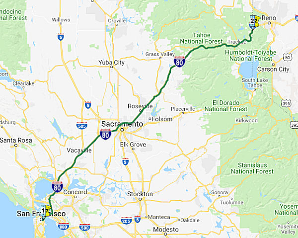 From Route 280 near First Street in San Francisco to the Nevada state line
near Verdi, Nevada, passing near Oakland, via Albany, via Sacramento,
passing near Roseville, via Auburn, via Emigrant Gap, via Truckee and via
the Truckee River Canyon.
From Route 280 near First Street in San Francisco to the Nevada state line
near Verdi, Nevada, passing near Oakland, via Albany, via Sacramento,
passing near Roseville, via Auburn, via Emigrant Gap, via Truckee and via
the Truckee River Canyon.
Post 1964 Signage HistoryAs defined in 1963, Route 80 was defined to run from "Route 280 in San Francisco to the Nevada state line near Verdi, Nevada, passing near Division Street in San Francisco, passing near Oakland, via Albany, via Sacramento, passing near North Sacramento, passing near Roseville, via Auburn, via Emigrant Gap, via Truckee and via the Truckee River Canyon." Note that Route 280 is the present-day Route 1 (see above). Within Sacramento, the route ran along what had been LRN 6 and LRN 11, and also included all of LRN 98.
In 1968, Chapter 282 transferred the portion from I-280 (present-day Route 1) to US 101 (LRN 223) to Route 241, and defined a new routing for Route 280 that turned into Route 480 at First Street and I-80. This ended up splitting the definition of Route 80, giving the current segment.
Reroutings in Sacramento
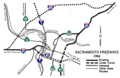
In Sacramento, this route (at times) was to have been Route 880. For a full discussion of the proposed freeway reroutings in Sacramento, see the maps discussion on Sacramento. See the 1935 section for the older portions of I-80, as well as the pages on US 50 and Route 51. Here is the history related to that numbering. Note that none of this changed the actual legislative definition of Route 80, only the routing:
The bypass I-80 realignment was pretty comprehensive; it followed the
SP (now UP) rail line all the way up through North Sacramento to the
present I-80/Route 51/Route 244 interchange. What is now Route 51
would have become an extension of Route 160 north of the Route 51/Route 160 split, while the present American River crossing would
have been a "spur" ramp connecting the two facilities. The I-80
reroute would have been an "express" facility, with no interchanges
between its north end at I-880/Route 244 and its merge with the
original route south of the American River. Route 160 traffic would
have had to depart I-80 where Business Route 80/Route 51 does today; the original
I-80 facility would be primarily for local traffic access.
(Source: Sparker on AAroad, 10/21/2018; Sparker on AAroads, 10/21/2018)
One plan at the time showed an interchange at Marconi Avenue. There
would have also been a connection to SB Route 160 and from NB Route 160 and an interchange at a proposed extension of Exposition Blvd
under the SP tracks (the interchange with Route 160 would have
eliminated the buttonhook ramps and horseshoe bridge on Route 160 at
Royal Oaks Drive. At the junction with the old I-80, there would have
been collector/distributor ramps down to E Street. Arden, El Camino,
and Marconi would all have been reconfigured onto new overpasses over
the SP railroad and the new freeway. All 3 bridges were eventually
built on those proposed alignments in the early 80s in preparation for
the light rail system.
(Source: Joe Rouse on AAroads, 10/22/2018)
The bridges on Arden Way and El Camino Real ended up, after the
recission of the I-80 Bypass, being a functional gift from Caltrans to
the City of Sacramento -- having been constructed to accommodate both
the railroad and the proposed freeway. On Arden Way, they replaced a
grade crossing where the gates were down about as much as they were up
-- that rail line connected Elvas Junction, where the SP lines from
Southern California (via Fresno & Stockton) and the Bay Area
converged, to the destination of most manifest (non-container) trains:
the sprawling Roseville Yard, then the largest in the SP system. The
city had long sought an overpass; because the planned Bypass I-80
facility followed that rail line, Caltrans started construction on
this by 1973, prior to Adriana Gianturco taking the reins at the
agency. To the immediate north, El Camino Real (old US 40/99E and part
of LRN 3) ducked under the tracks on a narrow 2-lane underpass that
had long outlived its configuration; once again, construction began
about '74, a year before Gianturco's administration. Both bridges had
spans that were designed to accommodate the parallel double-track rail
line plus 8 lanes of freeway. The original alignment of LRN 3 turned
north from El Camino Real on a broad curve leading to Auburn Blvd.
right at the east end of the original narrow underpass; this was
covered up by the berm of the new bridge, requiring traffic wishing to
access Auburn Blvd. to go a couple of blocks east and then north on a
local street.
(Source: Sparker on AAroads, 10/23/2018)
At this time, there were a number of differences from the present-day interchanges, visible from the historic aerials site. The I-80/Riverside interchange had a left exit from the EB lanes. There were also shows ramps from EB lanes to Auburn Blvd via what is now Whyte Avenue, as well as ramps at what is now Cirby Way. At the I-80/Watt Ave South interchange, the EB offramp was aligned directly onto EB Auburn Blvd. For traffic on WB Auburn Blvd to continue WB, the right lane swung right and then back to the left to an intersection with the traffic exiting the EB freeway. I-80 NE corridor (current BR-80/CA 51) had old configurations for almost all interchanges. The only interchanges that remain the same in 2009 are the junction with Route 160, Marconi Ave, Howe Ave EB, and Auburn/Bell EB.
 1972.
I-880 (present-day I-80) was completed; I-80 in the median was completed
but was not opened to traffic, ending at a long viaduct to nowhere just
south of where it left then I-880. Note: The I-880 numbering actually
makes sense, and the route would have connected with Route 244 (never
constructed) and then with Route 143, forming a loop back to US 50. It
would have continued as Route 244, and continued to Route 65.
1972.
I-880 (present-day I-80) was completed; I-80 in the median was completed
but was not opened to traffic, ending at a long viaduct to nowhere just
south of where it left then I-880. Note: The I-880 numbering actually
makes sense, and the route would have connected with Route 244 (never
constructed) and then with Route 143, forming a loop back to US 50. It
would have continued as Route 244, and continued to Route 65. Nathan Edgars looked at traffic counts, and came up with the following:
Route 80: Tower Bridge, over Capitol/N to 29th-30th, then a break to Broadway at 29th-30th and up 29th-30th
Route 99: from the south to Broadway, then west on Broadway, then a break to the east end of the I Street Bridge and up Jibboom Street
Route 16 cut back to I-5 at the east end of the I Street Bridge
Route 99 removed from P and Q Streets and instead routed back west on Broadway, replacing Route 16, but only to Route 275, where it broke until Jibboom Street
A discussion of the Highways to Boulevards program during the March 2022
CTC meeting identified the following segment(s) as potential Highways to
Boulevards conversion projects: I-80 near Cirby Way (~ PLA 0.657); I-80
near Rocklin Road/Sierra College (~ PLA 6.065 to PLA 7.42)
(Source: March 2022 CTC Agenda, Agenda Item 4.3)
Pre 1964 Signage HistoryNote: In general, for additional history of US 40 or the Lincoln Highway, see the page on US 40.
Frank Lloyd Wright original submitted an alternative design for the Bay Bridge.The proposed Butterfly Bridge would have spanned from Army Street (now Chavez) and Third Street to its eastern terminus on Bay Farm Island, just north of the Oakland Airport. Wright and Polivka saw steel truss bridges as extravagant and obsolete, so the design was all reinforced concrete, resting on a series of giant hollow almond-shaped piers - which they claimed to be earthquake-proof construction. Long curved arms would carry six lanes of traffic and two pedestrian walkways, supported by two arches that would be connected by a butterfly-shaped garden park as "a pleasant relief and perhaps a stopping point for the traffic."
Tom Fearer has an extensive history of the highway reroutings resulting from the construction of the Bay Bridge in his Gribblenation Blog Interstate 80 over the San Francisco-Oakland Bay Bridge. This details all the reroutings of US 101, US 40, US 50, and related state highways from the start of construction through the Interstate era.
This segment of the route was originally signed as follows:
 As cosigned
US 40/US 50/US 99E between Sacramento and Roseville. This was LRN 3,
defined in 1909.
As cosigned
US 40/US 50/US 99E between Sacramento and Roseville. This was LRN 3,
defined in 1909. The segment of US 40 (present-day I-80) between Reno and Sacramento was part of the Lincoln Highway.
Alternate US 40
There was also an Alternate US 40, also signed (apparently) in the
mid-1930s. This ran N from 2 mi SW of Davis along present-day Route 113 to
near Tudor (LRN 7 between US 40 and Route 16; LRN 87 between Route 16 and
Tudor); then along present-day Route 70 between Marysville and US 395 (LRN 87 between Marysville and Oroville; LRN 21 between Oroville and US 395).
It was cosigned with US 395 into Reno, NV.
The initial routing of US 40 was aligned over LRN 7 into Benicia, over
the Martinez-Benicia Ferry and LRN 14 towards Oakland. From Crockett US 40
followed LRN 14 west on San Pablo Avenue to Oakland to a terminus at 14th
Street and Broadway. The primary driver of US 40 being routed away from
Benicia and Martinez was the completion of the original Carquinez Bridge
in 1927 (opening date: 5/21/1927). The Carquinez Bridge originally carried
the final alignment of the Lincoln Highway when it opened as a private
toll bridge (the Lincoln Highway was originally aligned over Altamont Pass
on a route that eventually became US 48, then US 50, and is now I-580). US 40 was reported rerouted through Vallejo via the Carquinez Bridge and the
American Canyon Route on the 8th Biannual Report by the
Division of Highways in November 1932.
(Source: Gribblenation Blog, "Interstate 80 west over the Carquinez Bridge to the San Francisco-Oakland Bay Bridge")
During June 1955, the California Senate authorized construction of a
second Carquinez Bridge. The January/February 1956 California Highway and
Public Works Guide discusses the upcoming project to upgrade US 40/LRN 14
from Richmond to the Carquinez Strait to Freeway Standards. The second
Carquinez Bridge was projected to be completed in late 1958. The second
Carquinez Bridge opened to traffic on November 25th, 1958. The
second Carquinez Bridge would become the northbound lanes of the US 40/I-80 freeway and remain so on the modern Interstate.
(Source: Gribblenation Blog, "Interstate 80 west over the Carquinez Bridge to the San Francisco-Oakland Bay Bridge")
The 1927 Carqueinz Bridge was determined to be seismically unstable
following the 1989 Loma Prieta Earthquake. Subsequently a new Carquinez
Bridge was built to carry westbound I-80, this structure opened on
November 11th, 2003. Upon the completion of the 2003 Carquinez
Bridge the 1927 structure was demolished piecemeal which was completed in
2007.
(Source: Gribblenation Blog, "Interstate 80 west over the Carquinez Bridge to the San Francisco-Oakland Bay Bridge")
US 99W Segment (Davis to Sacramento)
Yolo Causeway
 In 1961, the freeway conversion of substandard segments of US 40 between the
Carquinez Bridge and Sacramento were being planned. This included a
replacement Yolo Causeway project. The plan was to open the new structures
in 1962. The original Yolo Causeway was expanded in 1933 to make room for
an undivided four lane roadway. The new Yolo Causeway would be two dual
structures consisting of three lanes apiece providing a necessary
expansion of US 99W/US 40/LRN 6. The new causeway was completed in late
1963. In 1967, the new I-80 alignment through Sacramento replaced the
former surface alignment of US 99W/US 40 over the Tower Bridge (which
became Route 275).
In 1961, the freeway conversion of substandard segments of US 40 between the
Carquinez Bridge and Sacramento were being planned. This included a
replacement Yolo Causeway project. The plan was to open the new structures
in 1962. The original Yolo Causeway was expanded in 1933 to make room for
an undivided four lane roadway. The new Yolo Causeway would be two dual
structures consisting of three lanes apiece providing a necessary
expansion of US 99W/US 40/LRN 6. The new causeway was completed in late
1963. In 1967, the new I-80 alignment through Sacramento replaced the
former surface alignment of US 99W/US 40 over the Tower Bridge (which
became Route 275).
(Source: Gribblenation Blog (Tom Fearer), "Former US Route 99 West from West Sacramento to Red Bluff", August 2021)
In the early 1960s construction was started on a
replacement for the Yolo Causeway. The replacement connected the completed
six-lane freeway at Swingle on the W with the West Capitol Avenue
interchange on the E. In this project, the existing three-mile wood and
concrete causeway was replaced with two reinforced concrete bridge
sections separated by nearly a mile of earth embankments. Each bridge was
composed of twin, parallel, three lane structures with the W unit 2,880 ft
long and the E unit 8,880 ft. After the new causeway was completed, the
old causeway was removed and buried.
(Source: Undated news article, pre-1962, via Joel Windmiller,
1/29/2023)
West Sacramento
The West Sacrament portion of this route was originally part of US 40 and US 99W. With the 1964 renumbering, this segment became part of I-80. When the Sacramento rearrangement occurred in 1981, I-80 was realigned to a new northerly routing previously proposed as I-880, and the older freeway became Business Route 80—US 50 between I-80 and Route 99, and unsigned Route 51 between Route 99 and I-80 near Roseville. As the older I-80 was constructed using interstate funds, the segment was administratively designated as FAI 305 (I-305), but this number is not defined legislatively. It is important to note that, although it is now signed as US 50, this segment was never part of historic US 50.
Within Sacramento, early LRN 6 departed the City via
the I Street Bridge to West Sacramento. The I Street Bridge opened to
traffic over the Sacramento River in 1911 as a swing span carrying the
Southern Pacific Railroad and highway traffic. The original definition of
LRN 6 from the 1909 First State Bond Act was Sacramento west to Woodland
Junction. From West Sacramento (then known as Washington), LRN 6 traversed
the Yolo Causeway to the City of Davis. The Yolo Causeway was first
referenced in 1913 as an upcoming bridge to be constructed over Stony
Creek north of Orland as part of the Pacific Highway and LRN 7. The Stony
Creek Bridge was to have a planned length of 1,200 feet and would feature
a arch concrete design, with an anticipated opening during December 1913.
By 1914, the design of the upcoming Yolo Causeway included three miles of
concrete trestles, and would connect to LRN 6 from West Sacramento to
Davis (also designed and out for construction bid). Early plans for LRN 6
had it connect from the I Street Bridge to the upcoming Yolo Causeway. The
causeway opened in May 1916.
(Source: Gribblenation Blog (Tom Fearer), "Former US Route 99 West from West Sacramento to Red Bluff", August 2021)
The M Street Bridge was originally constructed as a
railroad swing structure in 1911. The M Street Bridge was utilized by the
Sacramento North Railway, Oakland Antioch & Eastern Railway and
Northern Electric Railway. The construction of LRN 6 and the Yolo Causeway
saw roadway lanes added to the M Street Bridge as part of the realignment
of the highway. In 1925, a fire that destroyed the existing Sacramento
Northern Railroad Subway on LRN 6 in West Sacramento, and bids were put
out by the State to construct a new subway and eliminate a blind curve. By
1927, the subway had been completed and it connected to a completed M
Street Bridge approach in West Sacramento, providing a new alignment of US 99/US 40/LRN 6 through the 1926 Sacramento Northern Railroad Subway. In
1934, the Tower Bridge (future Route 275) opened. The Tower Bridge was a
direct replacement for the previous M Street Bridge. During the process of
construction of the Tower Bridge the M Street Bridge was removed and US 99W/US 40/LRN 6 crossed the Sacramento River via a temporary structure.
Unlike the swing design of the M Street Bridge, the design of the Tower
Bridge features a vertical lift span.
(Source: Gribblenation Blog (Tom Fearer), "Former US Route 99 West from West Sacramento to Red Bluff", August 2021)
By 1935, US 99W entered West Sacramento multiplexed
with US 40 on LRN 6 over the M Street Bridge west from downtown
Sacramento. US 99W/US 40 traversed West Sacramento westward on Capitol
Avenue towards the Yolo Causeway. US 99W/US 40 then followed LRN 6 west on
the Yolo Causeway towards what is now County Road 32A and the grade of
I-80 through Webster siding into Davis. US 99W/US 40 enteried Davis on LRN 6 via Olive Drive, and then split onto LRN 7 via Richards Boulevard over
the Southern Pacific Railroad.
(Source: Gribblenation Blog (Tom Fearer), "Former US Route 99 West from West Sacramento to Red Bluff", August 2021)
 In 1954, the West Sacramento Freeway opened. The West Sacramento Freeway served as a limited
access realignment of US 99W/US 40/LRN 6 off Capitol Avenue from the Tower
Bridge west to the Yolo Causeway. The West Sacramento Freeway was designed
with wide lane systems at either end allow for an additional bridge over
the Sacramento River just S of Tower Bridge—this permits the Yolo
Causeway to be widened, and allows US 99W/US 40/LRN 6 to serve as a full
bypass of downtown Sacramento. The US 99W and US 40 intersection in Davis
was shifted to a new interchange configuration, which is currently where
Route 113 transitions from I-80 in Davis. The freeway includes seven
cloverleaf structures connecting the main road and crossroads. The center
median is wide enough to accommodate a third lane on each side in the
future. The roadway off the S side of the freeway near the Tower Bridge
can be extended to connect with a future crossing of the Sacramento River
downstream from the present bridge. The freeway eliminated a hazardous
three-lane stretch through business areas where reduced speed limits were
in effect. It cost $3,500,000 to construct (1954 dollars), plus right of
way costs of $1,000,000 (1954 dollars).
In 1954, the West Sacramento Freeway opened. The West Sacramento Freeway served as a limited
access realignment of US 99W/US 40/LRN 6 off Capitol Avenue from the Tower
Bridge west to the Yolo Causeway. The West Sacramento Freeway was designed
with wide lane systems at either end allow for an additional bridge over
the Sacramento River just S of Tower Bridge—this permits the Yolo
Causeway to be widened, and allows US 99W/US 40/LRN 6 to serve as a full
bypass of downtown Sacramento. The US 99W and US 40 intersection in Davis
was shifted to a new interchange configuration, which is currently where
Route 113 transitions from I-80 in Davis. The freeway includes seven
cloverleaf structures connecting the main road and crossroads. The center
median is wide enough to accommodate a third lane on each side in the
future. The roadway off the S side of the freeway near the Tower Bridge
can be extended to connect with a future crossing of the Sacramento River
downstream from the present bridge. The freeway eliminated a hazardous
three-lane stretch through business areas where reduced speed limits were
in effect. It cost $3,500,000 to construct (1954 dollars), plus right of
way costs of $1,000,000 (1954 dollars).
(Source: Gribblenation Blog (Tom Fearer), "Former US Route 99 West from West Sacramento to Red Bluff", August 2021; Folsom Telegraph, 6/17/1954 via Joel Windmiller 1/29/2023;
Sacramento Bee, 4/30/1951 via Joel Windmiller 2/1/2023)
In 1967, a portion of the West Sacramento Freeway from
West Acres Road to the Tower Bridge became Route 275. This was due to the
shift of I-80 onto the new connector over the Sacramento River east to
what was the US 99E Freeway. At this point, I-80 was still running through
Sacramento, this this new connector was S of Tower Bridge.
(Partial Source: Gribblenation Blog (Tom Fearer),
“US Route 50 in West Sacramento and Sacramento (hidden Interstate 305)”, January 2021)
Pre-1981 Downtown Sacramento Routing (now BR 80—US 50 and Route 51)
Note: Prior to 1981, I-80 was routed through Sacramento via the W-X Freeway and the Elvas Freeway. For more details on this portion of the routing, see the US 50 page for the portion between the West Sacramento Freeway and Route 99, and see the Route 51 page for the Elvas Freeway portion between Route 99 and the junction with present-day I-80 in northern Sacramento.
West Sacramento to North Sacramento (originally I-880)
 Bypass") In 1958, the US Bureau of Public Roads proposed a bypass route to carry
traffic around and N of Sacramento. The route was described in a letter to
state highway engineer C. T. McCoy. The route was described roughly, with
the state being asked to submit a route for future inclusion in the
interstate system. The route would begin near the junction of Harbor Blvd
and the West Sacramento Freeway and extend N across the Sacramento River
and then E to a junction with the Roseville Freeway near Watt Avenue.
In 1958, the US Bureau of Public Roads proposed a bypass route to carry
traffic around and N of Sacramento. The route was described in a letter to
state highway engineer C. T. McCoy. The route was described roughly, with
the state being asked to submit a route for future inclusion in the
interstate system. The route would begin near the junction of Harbor Blvd
and the West Sacramento Freeway and extend N across the Sacramento River
and then E to a junction with the Roseville Freeway near Watt Avenue.
(Source: Sacramento Bee, 1958 via Joel Windmiller, 2/5/2023)
 In 1959, planning started for the Arcade Freeway, which was designed to
provide a bypass around Sacramento for motorists on US 40 and US 50. It
would swing in a great semi-circle across the N area of the city,
connecting with US 50 at Bradshaw Road and ultimately with US 40 at Harbor
Blvd in W. Sacramento. Starting at Bradshaw Road E of Sacramento, the
freeway would cross the American River and bisect the Haggin Bottoms area.
It would go beneath Arden Way E of Fair Oaks Blvd and proceed N about on
the line of Walnut Ave. At approximately Whitney Avenue, it would swing W
along Auburn Blvd and the Roseville Freeway (US 40). The route would be
along the N edge of Del Paso Park and would cross the city of N.
Sacramento in the vicinity of North Avenue. The portion to the W of US 40
would eventually get the designation of I-880 (for the bypass around
Sacramento), and would later be renumbered I-80. The portion E of US 40 to
US 50 was part of planned Route 143, which was not constructed.
In 1959, planning started for the Arcade Freeway, which was designed to
provide a bypass around Sacramento for motorists on US 40 and US 50. It
would swing in a great semi-circle across the N area of the city,
connecting with US 50 at Bradshaw Road and ultimately with US 40 at Harbor
Blvd in W. Sacramento. Starting at Bradshaw Road E of Sacramento, the
freeway would cross the American River and bisect the Haggin Bottoms area.
It would go beneath Arden Way E of Fair Oaks Blvd and proceed N about on
the line of Walnut Ave. At approximately Whitney Avenue, it would swing W
along Auburn Blvd and the Roseville Freeway (US 40). The route would be
along the N edge of Del Paso Park and would cross the city of N.
Sacramento in the vicinity of North Avenue. The portion to the W of US 40
would eventually get the designation of I-880 (for the bypass around
Sacramento), and would later be renumbered I-80. The portion E of US 40 to
US 50 was part of planned Route 143, which was not constructed.
(Source: Sacramento Bee, 12/13/1959, via Joel Windmiller, 2/16/2023)
North Sacramento to Auburn
Note: Tom Fearer, in the Gribblenation Blog "Interstate 80 in the Sierra Nevada Mountains" (1/14/2022) covers much of these segments in gory detail. The problem is that he generally goes chronologically, and jumps back and forth between the outskirts of Sacramento and the Nevada State Line, as opposed to working segment by segment from West to East, and then covering each segment chronologically. As such, summarizing his information here is difficult. Please visit his blog for lots of details on these segments.
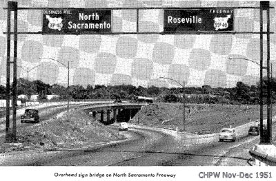
 The planned routing through Roseville was published in the Sacramento Bee in August 1952. This shows a new routing distinct
from the original US 40 routing along Auburn Blvd, with interchanges at
Watt Avenue, Madison Ave, Spruce Avenue, Watson Way (Antelope Road),
Auburn Blvd, Sunrise/Folsom (Douglas), and Eureka.
The planned routing through Roseville was published in the Sacramento Bee in August 1952. This shows a new routing distinct
from the original US 40 routing along Auburn Blvd, with interchanges at
Watt Avenue, Madison Ave, Spruce Avenue, Watson Way (Antelope Road),
Auburn Blvd, Sunrise/Folsom (Douglas), and Eureka.
(Source: Sacramento Bee, 8/20/1952 via Joel
Windmiller, 1/21/2023)
 In 1957, it was reported that the Watt Avenue interchange was being reworked
to permit a free right hand turn from the freeway to the NB lanes of Watt
Avenue leading to McClellen AFB. This eliminated the need for
McClellen-bound traffic to make a sharp left-turn at the stop light on
Auburn Blvd. The ramp leading to Watt Avenue to the freeway was to be
removed and a new one built to the east.
In 1957, it was reported that the Watt Avenue interchange was being reworked
to permit a free right hand turn from the freeway to the NB lanes of Watt
Avenue leading to McClellen AFB. This eliminated the need for
McClellen-bound traffic to make a sharp left-turn at the stop light on
Auburn Blvd. The ramp leading to Watt Avenue to the freeway was to be
removed and a new one built to the east.
(Source: Newspaper article, 11/15/1957 via Joel Windmiller,
2/5/2023)
In Roseville, it appears that I-80 had an exit that no longer exists. According to an article in the Sacramento Bee, back in the 1960s, EB I-80 had an exit to NB Riverside Boulevard, that was a left exit that went through a tunnel under the westbound lanes and up to Riverside.
 In 1955, public meetings were held to explore various
routes for the US 40 freeway between 0.5 mi E of Rocklin and 1 mi E of
Newscastle. All routes start 0.5 mi E of Roseville at the E end of the Ben
Ali to Roseville Freeway and end a mile E of Newcastle at the W end of the
proposed Newcastle to Auburn Freeway just adopted. Route A departs from
the existing road 0.5 mi E of Roseville and continues along Secret Ravine,
S of Rocklin, Loomis, and Penryn. Near the end of Secret Ravine the line
turns N and rejoins the existing road a mile E of Newcastle. All the other
routes generally follow the existing road with various proposals for going
through or around Rocklin and Loomis.
In 1955, public meetings were held to explore various
routes for the US 40 freeway between 0.5 mi E of Rocklin and 1 mi E of
Newscastle. All routes start 0.5 mi E of Roseville at the E end of the Ben
Ali to Roseville Freeway and end a mile E of Newcastle at the W end of the
proposed Newcastle to Auburn Freeway just adopted. Route A departs from
the existing road 0.5 mi E of Roseville and continues along Secret Ravine,
S of Rocklin, Loomis, and Penryn. Near the end of Secret Ravine the line
turns N and rejoins the existing road a mile E of Newcastle. All the other
routes generally follow the existing road with various proposals for going
through or around Rocklin and Loomis.
(Source: Unspecified newspaper, 7/7/1955 via Joel Windmiller,
2/17/2023)
Auburn to Emigrant Pass
 In 1954, it was reported that a four-lane freeway routing
for US 40 (future I-80) between Colfax (~ PLA 33.019) and a point W of
Gold Run (~ PLA 40.167) was under study. It would shorten travel distance
about 1 mi and eliminate sharp turns and steep grades. The routing runs E
of the existing highway (a portion of Route 174 (LRN 25) and Rollins Lake
Road) between Colfax and Magra, and W of the existing highway (Magra Road)
between Magra and Gold Run.
In 1954, it was reported that a four-lane freeway routing
for US 40 (future I-80) between Colfax (~ PLA 33.019) and a point W of
Gold Run (~ PLA 40.167) was under study. It would shorten travel distance
about 1 mi and eliminate sharp turns and steep grades. The routing runs E
of the existing highway (a portion of Route 174 (LRN 25) and Rollins Lake
Road) between Colfax and Magra, and W of the existing highway (Magra Road)
between Magra and Gold Run.
(Source: Auburn Journal, 4/29/1954, via Joel Windmiller, 2/1/2023)
 In 1956, it was reported that the CHC was considering
adoption of a freeway routing between 1 mi W of Gold Run and Blue Canyon
Road in Placer County. The route follows the existing highway with some
line changes to eliminate sharp turns.
In 1956, it was reported that the CHC was considering
adoption of a freeway routing between 1 mi W of Gold Run and Blue Canyon
Road in Placer County. The route follows the existing highway with some
line changes to eliminate sharp turns.
(Source: Colfax Record, 3/23/1956 via Joel Windmiller, 2/17/2023)
Emigrant Pass to Donner Pass
 In 1956, discussions were held regarding the proposed routings near Emigrant
Pass.
In 1956, discussions were held regarding the proposed routings near Emigrant
Pass.
(Source: Unnamed 1956 Newspaper via Joel Windmiller, 2/17/2023)
 In 1956, it was reported that the CHC was considering adoption of a freeway
routing between Hampshire Rocks in Placer County and Soda Springs in
Nevada County. The recommended route runs parallel with and just to S of
the existing highway. The present highway would serve as a frontage road
or local service road after the freeway is completed.
In 1956, it was reported that the CHC was considering adoption of a freeway
routing between Hampshire Rocks in Placer County and Soda Springs in
Nevada County. The recommended route runs parallel with and just to S of
the existing highway. The present highway would serve as a frontage road
or local service road after the freeway is completed.
(Source: Colfax Record, 3/23/1956 via Joel Windmiller, 2/17/2023)
In June 2017, TomFearer
provided some history of Donner Pass Road on AARoads, and there is
more in his Gribblenation Blog Posts: Donner Pass had the first recorded wagon crossing in 1844. In 1846-47 an 81-member party of immigrants led by George and Jacob
Donner was forced to winter-over adjacent to Donner Lake. Thirty-six died
from cold and starvation, and are notable for reports of cannablism in the
name of survival. The first route over the Sierras via the Donner Pass
area wasn't too much different than Donner Pass Road ultimately ended up
being. The main difference was that the route for wagons was much steeper
than the Lincoln Highway iteration ultimately ended up being. This was
known as the Dutch Flat & Donner Lake Wagon Road, which was completed
by 1864 to assist with construction of the First Trans-Continental
Railroad. Visit this site for more details about the Dutch Flat & Donner Lake Wagon Road.
(Source: Gribblenation Blog (Tom Fearer), "Interstate 80 in the Sierra Nevada Mountains", 1/14/2022; Bill Sanford "Getting out of the Central Valley: Highway passes to the east" (emailed
draft 10/1/2010))
The original purpose built road over Donner Pass was the Dutch Flat &
Donner Lake Road (DF&DLR). The DF&DLR was a wagon route over
Donner Pass that was constructed by the Central Pacific Railroad to assist
in construction of the First Transcontinental Railroad. In 1861, the State
of California granted the Central Pacific a 10 year franchise on toll
rights to the DF&DLR, which completed by 1864. The DF&DLR was used
to finance the Central Pacific's construction of the First
Transcontinental Railroad from 1864 to 1868. The DF&DLR was likely not
tolled after rail service opened to Reno in 1868. The DF&DLR became a
public highway in 1871 and was only loosely maintained given rail service
had become the easiest form of transportation over Donner Pass. The
DF&DLR became one of the earliest California State Highways in 1909.
The primary purpose of State Highway maintenance on the DF&DLR was to
improve the roadway for ease of travel during the early automobile era.
(Source: Gribblenation Blog: Donner Pass; hunting for the Dutch Flat & Donner Lake Road and abandoned Central Pacific Railroad Tunnels, 10/13/18)
The infamous wagon train that lent its name to the Donner Pass crossed it
in 1846-1847, but established wagon trails didn’t appear there until
nearly 20 years later, built to support the Central Pacific Railroad as it
crossed the Sierra Nevadas. The first automobile – driven by
Alexander Winton – reportedly crossed those wagon trails in 1901,
and California designated the wagon trail over the Donner Pass a state
highway in 1909, so when Carl Fisher and his group pieced together the
Lincoln Highway four years later, they simply used the same route for the
northern branch between Fallon, Nevada, and Sacramento. This routing (when
headed up to the summit from Donner Lake) entered the Central Pacific RR
tunnel that bore underneath the pass itself, continued through a snow shed
and another railroad tunnel, and only then diverged from the railroad to
continue the climb up over the summit. Although there was a protocol for
traversing the RR tunnel, the system resulted in a number of accidents
– enough to warrant the construction of the country’s first
auto road underpass beneath a railroad just a year later. The concrete
underpass went in roughly where automobiles exited the snow shed near CPRR
tunnel No. 8 and forced a minor re-routing of the Lincoln Highway. The
railroad abandoned that section of line in 1993; the purpose-built US 40,
now known as the Donner Pass Road, replaced the Lincoln Highway in 1926
and was itself replaced by I-80 in the 1960s.
(Source: Hemmings Daily, 1/2/2018)
In addition to the Dutch Flat & Donner Lake Wagon Road there was two
additional wagon roads that were apparently used: Coldstream Pass and
Roller Pass to the south of Donner Pass which were in use by 1846. This site has some really good links to maps showing all the wagon routes alongside Donner Pass Road in addition to the rail alignments. The Dutch
Flat & Donner Lake Wagon Road became a state highway apparently in
1909 with a realignment due to rail crossing accidents in 1912.
(Source for some: Max R on AAroads, June 2017)
The first legislative appropriation to improve the DF&DLR was in 1911
followed by an act in 1913 (Chapter 619) to remove an at-grade crossing of
the First Transcontinental Railroad. The 1913 legislation served to remove
the at-grade rail crossing the DF&DLR took at Central Pacific Tunnel
#6 (which was leased to the Southern Pacific in 1885) which was replaced
by an underpass between Tunnel #7 and Tunnel #8. The 1913 DF&DLR is
often cited as one of the first highway rail underpasses in the United
States. 1913 was also when the route was chosen to be signed as the
Northern Spur of the Lincoln Highway in California, aligned over Donner
Pass Road. The 1918 State Highway Map is the earliest that shows a road
going over Donner Pass but no route names. In 1921, the Victory Highway
was co-signed with the Northern Lincoln Highway on the DF&DLR. By
1926, the DF&FLR over Donner Pass had been replaced by the newly
constructed Donner Pass Road. The original routing of Donner Pass Road
from Donner Pass east to Donner Lake used very little of the DL&DLR as
the grades were far too high to facilitate increasing interstate travel.
Donner Pass Road ultimately took out almost all of the really steep grades
by using hairpins that approached the pass from Donner Lake. The
DF&DLR remained south of Donner Pass Road from Donner Pass east to
Donner Lake. The DF&DLR converged with Donner Pass Road at Old Highway
Drive. Tom Fearer's blog page (from which this paragraph is condensed) has some good maps (and links to old maps) showing these older and former routings.
(Source: Gribblenation Blog: Donner Pass; hunting for the Dutch Flat & Donner Lake Road and abandoned Central Pacific Railroad Tunnels, 10/13/18)
Ultimately the Lincoln Highway was replaced by US 40. By 1926, Donner
Pass Road is shown as unimproved west out of Truckee to Donner Lake but
graded over Donner Pass. By 1930 US 40 appears on State Highway Maps and
all of Donner Pass Road from Truckee to the actual Pass appears to be
classified as "Improved." By 1934 all over US 40 over the Sierras appears
to have been paved. Not much changes until the Federal Aid Highway Act of
1956 which of course led to the Interstate system. The first visual change
that can be seen on the state highway map with Donner Pass Road being
bypassed is in 1960 when a new stub of I-80 is shown running from the
Nevada state line west past Truckee to Donner Lake. It isn't until the
1967 State Highway Map that US 40 completely disappears from California.
(Source for some: Max R on AAroads, June 2017)
 In 1958, funds were allocated to start work on the $17.5 million freeway over Donner Summit, using a new
routing that ran N of the previous 10.3 mi twisting route. It was
anticipated that it would take three construction seasons to complete the
segment. The section extended from Soda Springs to the E end of Donner
Lake in Nevada County. Once this segment was completed, the only section
remaining to be four-laned would be the 11 mi section near Emigrant Gap.
By 1960, the first of the three jobs in the contract was progressing. The
initial work was grading the nearly 7 mi of the route from where it
connects with the completed freeway at the E end of Donner Lake to the
vicinity of the new 7,239' summit, two mi N of the present 7,135' Donner
Summit. Grading on the remaining 3.5 mi from near the new summit to Soda
Springs, with an undercrossing at Castle Peak and overcrossing at Soda
Springs was to be put out to bid in 1961. The project was expected to take
at least 3 construction seasons.
In 1958, funds were allocated to start work on the $17.5 million freeway over Donner Summit, using a new
routing that ran N of the previous 10.3 mi twisting route. It was
anticipated that it would take three construction seasons to complete the
segment. The section extended from Soda Springs to the E end of Donner
Lake in Nevada County. Once this segment was completed, the only section
remaining to be four-laned would be the 11 mi section near Emigrant Gap.
By 1960, the first of the three jobs in the contract was progressing. The
initial work was grading the nearly 7 mi of the route from where it
connects with the completed freeway at the E end of Donner Lake to the
vicinity of the new 7,239' summit, two mi N of the present 7,135' Donner
Summit. Grading on the remaining 3.5 mi from near the new summit to Soda
Springs, with an undercrossing at Castle Peak and overcrossing at Soda
Springs was to be put out to bid in 1961. The project was expected to take
at least 3 construction seasons.
(Source: Sacramento Bee, 10/17/1958, Sacramento Bee, 9/19/1960, via
Joel Windmiller, 2/5/2023)
Truckee to the Nevada State Line
Recalculating...
StatusSan Francisco Approach and Western Span Oakland-Bay Bridge (~ SF 5.584L to SF 7.618)
Western Span Bike Path
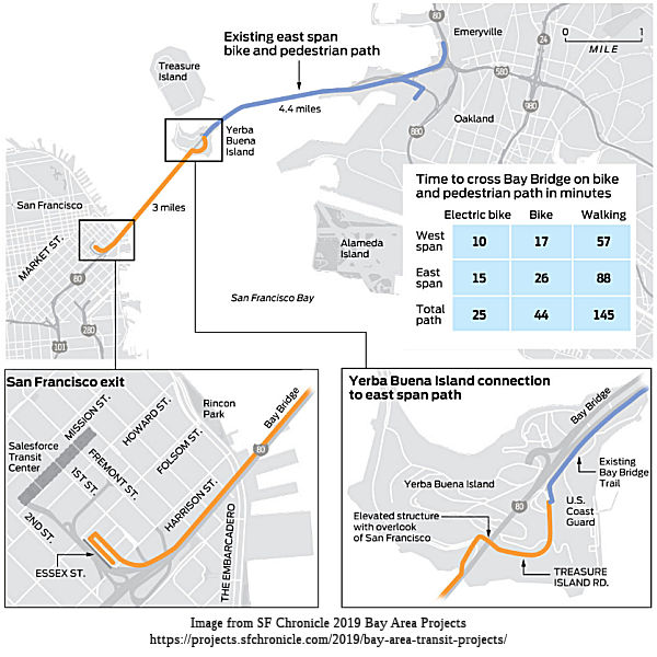 In December 2011, it was reported that exploration has begun on how to add bike and pedestrian lanes to the segment of the Bay Bridge between Yerba
Buena/Treasure Islands and San Francisco (the "west span"). The initial
plan is that the paths could be cantilevered off both sides of the upper
deck. Bicyclists and pedestrians would use the northern path and Caltrans
could use the southern path, though it would be possible to share both
paths. The additional weight of the two paths could cause the bridge to
flatten a bit, reducing clearance through the main shipping channel, the
study says. It could be solved by either shortening the suspender cables -
something that hasn't been done on a similar bridge - or by replacing the
bridge decks with a lighter material. To get from the east span to the
west span, cyclists would take a route along the south side of the island,
crossing over the tunnel, then looping around to the west span along one
of two alignments cut out of the steep hillside. In San Francisco, the
path could connect to one of six locations South of Market, including the
rooftop garden of the new Transbay Terminal, the Beale Street dog park now
being built or Folsom Street. The study on the bike path estimates the
cost at $500 million to $550 million in 2011 dollars, with estimated
timeframes of about 10 years of engineering, design and construction.
In December 2011, it was reported that exploration has begun on how to add bike and pedestrian lanes to the segment of the Bay Bridge between Yerba
Buena/Treasure Islands and San Francisco (the "west span"). The initial
plan is that the paths could be cantilevered off both sides of the upper
deck. Bicyclists and pedestrians would use the northern path and Caltrans
could use the southern path, though it would be possible to share both
paths. The additional weight of the two paths could cause the bridge to
flatten a bit, reducing clearance through the main shipping channel, the
study says. It could be solved by either shortening the suspender cables -
something that hasn't been done on a similar bridge - or by replacing the
bridge decks with a lighter material. To get from the east span to the
west span, cyclists would take a route along the south side of the island,
crossing over the tunnel, then looping around to the west span along one
of two alignments cut out of the steep hillside. In San Francisco, the
path could connect to one of six locations South of Market, including the
rooftop garden of the new Transbay Terminal, the Beale Street dog park now
being built or Folsom Street. The study on the bike path estimates the
cost at $500 million to $550 million in 2011 dollars, with estimated
timeframes of about 10 years of engineering, design and construction.
In February 2016, it was reported that Transportation
officials were narrowing the final designs for a bike and pedestrian path
on the western span of the Bay Bridge, but it could still be another
decade before the 2.9-mile structure from Yerba Buena Island to San
Francisco is funded and built, according to the Bay Area Toll Authority.
The impetus to build a western path comes from a desire to make it
possible to ride all the way from Oakland to San Francisco. The new
eastern span's biking and walking path currently stops short of Yerba
Buena Island because of a long series of construction delays. One big
question is where the path should touch down in San Francisco. Engineers
have narrowed those alternatives from 19 to six, including Essex Street,
the Embarcadero or a Caltrans paint yard. biking and walking structure on
the western span presents a number of engineering challenges. Attaching
the main span to the Bay Bridge is the biggest challenge, because it's not
easy to attach new steel to old steel. Old steel gets brittle. It can't be
welded. The old bridge must be partially taken apart and the new parts
must be integrated using bolts and plates to replace existing rivets.
There's also the issue of sinkage. Adding new weight will cause the bridge
to be six to eight inches lower, potentially endangering very tall ships
and angering the Coast Guard. To solve this problem, the suspension wires
could be tightened, raising the roadway back up six to eight inches.
Another big question is how to get the path across Yerba Buena Island. The
options include a bike and walking path that would be suspended from the
ceiling of the Yerba Buena Tunnel, providing a direct connection to the
west span. Less costly options include building paths above or below
Hillcrest Road, which winds around steep terrain on the south side of the
island. In San Francisco, the project would also feature "dual
high-capacity and high-speed elevators" on the Embarcadero to quickly move
people on and off the path. One option being considered would be to have
the elevators open first, in lieu of a ramp touchdown, which could be
built later. Engineers hope to come up with four alternative designs and
present cost estimates at a meeting planned for September 2016, and then
narrow them down to two options.
(Source: SFGate, 2/2/2016)
In November 2018, it was reported that a just released
study shows the western bike path is technically possible to build —
but it won’t be cheap, and it won’t be easy. Cost estimates
for the roughly three-mile path range from $341 million to nearly $429
million, figures that could rise as the design gets closer to completion.
There are numerous other challenges, including how to attach the new path
to an 82-year-old bridge and how to manage construction in a corridor
traversed by more than 266,000 motorists every day — not to mention
how to pay for it. This study is not the first time the region’s
transportation planners have looked at the potential of building a path
along the Bay Bridge’s western span, but this presentation will be
the closest they’ve come to understanding the full magnitude of
construction and its associated costs. Two studies in 2001 and 2011 looked
at options for a path, including where it might land in San Francisco, how
it would connect to Yerba Buena Island, and how the path would attach to
the bridge. Renewed interest for the west span path picked up in 2013,
when the east span, with a bicycle and pedestrian path from Oakland on the
south side of the bridge, first opened to the public. In 2016, the path
reached Yerba Buena Island, where a suite of improvements are planned to
accommodate a protected bikeway to Treasure Island. The most recent study
takes it a step further by selecting a preferred alternative and
completing up to 25 percent of the engineering designs in some places
along the span. Under this plan, the path would meet the eastern span on
the south side of Yerba Buena Island before wrapping around to the
island’s north side. From there, cyclists and walkers could turn to
Treasure Island or head west to San Francisco. The path would then follow
the bridge to the Fremont Street off-ramp and finally touch down on Essex
Street, where cyclists could connect to San Francisco’s network of
bike lanes. Along the way, engineers would need to erect steel cantilevers
on the north side of the bridge that would bolt into the bridge’s
steel frame, said Peter Lee, the MTC’s project manager for the west
span bike path. Because of the steel’s age, crews can’t weld
onto it, he said. There’s layers of lead paint that need to be
carefully managed and an increasingly shorter nightly construction window
as worsening traffic congestion continues to lengthen the definition of
“peak commute hours.” But, one of the biggest challenges is
the extra weight, which could lower the height of the suspension bridge by
as much as two feet and make it hard for large cargo ships to pass safely
underneath. The weight of the path can be offset by lightening the load in
other places, he said, such as resurfacing the roadway with a new,
lighter-weight asphalt, which would be part of the bridge’s regular
maintenance. This new study allows planners to take the potential path
into account when making those upgrades.
(Source: East Bay Times, 11/15/2018)
In March 2019, the SF Chronicle summarized the status
on this: It took nearly three years to open the Bay Bridge’s bike
path on the eastern span. Until early 2017, impatient cyclists and
pedestrians could only travel from Oakland to a spot short of Treasure
Island while the old bridge was being demolished. And they’ll have
to continue waiting to ride a bike, or walk, to San Francisco. After years
of studying how a bike path across the western span of the bridge would
work, planners and engineers finally came up with a design and unveiled it
in November. The cost has been whittled down to about $300 million after
earlier estimates of $1 billion. Finding that money will take years,
though, and it may require funding from a future tax or bond measure that
raises money for a new Transbay Tube for BART and other rail service. To
access the bridge’s bike path, a trail will need to be built from
the eastern span around Yerba Buena Island. Once across the bridge,
pedestrians and bicyclists would take a path following the Fremont Street
exit before sloping down to a landing near Essex Street.
(Source: SF Chronicle, 3/14/2019)
In December 2022, it was reported that East Bay and San
Francisco residents who want to cross the Bay on foot or bicycle have a
date to look forward to: 2030. That’s the year the Bay Bridge bike
path is expected to open, connecting West Oakland to downtown San
Francisco via Yerba Buena Island. The first part of the bike and foot path
was completed 10 years ago with the opening of the eastern span of the Bay
Bridge path, connecting Oakland to Yerba Buena Island. The next phase will
involve connecting the existing eastern span bike path that ends at Vista
Point on Yerba Buena Island to Treasure Island. Then the final phase
involves connecting the paths on Yerba Buena and Treasure Islands to a
bike path that will cross the western span of the Bay Bridge. The path on
the western span hasn’t been designed yet, but it’s expected
to be separated from vehicle lanes. While the total funding to complete
the path by 2030 has not been secured, the MTC is confident it will come
in over the next seven years.
(Source: Berkeleyside, 12/21/2022)
Yerba Buena Island (~ SF 7.618L to SF R8.237)
Yerba Buena Route Adoption
In March 2015, the CTC actually adopted the freeway route on Yerba Buena Island. Recently reconstructed entrance and exit ramps on Route 80 on Yerba Buena Island prompted a review of the existing Freeway Agreement. It then became apparent that neither a Freeway Agreement or a Route Adoption had ever been completed for this portion of Route 80. There was an Act of Congress in 1931 entitled “An Act granting the consent of Congress to the State of California to construct, maintain, and operate a bridge across the Bay of San Francisco from the Rincon Hill District in San Francisco by way of Goat Island to Oakland.” The San Francisco-Oakland Bay Bridge was built in 1936. On December 20, 1962, there was an Agreement signed between the United States of America (US Navy) and the State of California. The purpose of the Agreement was to outline the mutual rights and obligations relating to the crossing of the San Francisco-Oakland Bay Bridge (SFOBB) over Yerba Buena Island and the construction and maintenance of roadways connecting Yerba Buena Island to the Bridge. After searching for information in 1933 Breed Act, soliciting information from the city and county of San Francisco and looking through documents in the Caltrans’ HQ Division of Design, it appears no Route Adoption was ever done for this portion of Route 80. After completion of the reconstruction of the SFOBB interchange on Yerba Buena Island , which is currently under construction, the Navy will transfer ownership of the interchange right of way on Yerba Buena Island to the city and county of San Francisco. A Freeway Agreement with the city of county of San Francisco will be completed following the transfer of ownership of right of way and the Route 80 Freeway Adoption. The Freeway Agreement with the city and county of San Francisco is targeted for mid-April of 2015. The wording of the route adoption was:
NOW, THEREFORE, BE IT RESOLVED by the Commission that pursuant to the authority vested in it by law, this Commission does hereby select, adopt, and determine the location of that segment of State Highway Route 80 from 0.1 miles east of Fifth Street to 1.7 miles west of W. Grand Avenue, in the city and county of San Francisco and in the county of Alameda, and officially designate it as 04-SF-80 and 04-Ala-80, a Freeway, as said location is shown on the Route Adoption map submitted by “Lenka” Culik-Caro Design Deputy District 4 Director
Yerba Buena Tunnel Corrosion
In February 2016, it was reported that Caltrans was
investigating possible corrosion in the Bay Bridge’s Yerba Buena
Island tunnel after a chunk of the concrete wall tumbled into the roadway
and narrowly missed hitting a motorist. Of concern to Caltrans, and to an
expert who examined a photo of the damage, is whether the incident is a
sign that water is causing more widespread problems in the 80-year-old
tunnel. The failure occurred at a point where the ceiling of the lower
deck — which serves as the deck for the westbound lanes above
— is connected to the tunnel wall. Since the investigation started,
Caltrans has realized the tunnel has more issues than they originally
thought. Thirteen problem areas have been identified; they range in size
from a few inches to a few feet and are on both sides of the tunnel.
Caltrans officials said rainwater is to blame for the corrosion. The water
is leaking from the more than 250 drain openings on the upper deck down to
the tunnel. The Yerba Buena Tunnel was built in the 1930s, the last major
rehabilitation was done more than 50 years ago, in the early sixties. The
upper and lower tunnels are separated by a deck that was installed in
1964, after rail service was eliminated on the lower deck.
Reinforced-concrete sections that make up the deck sit atop 12-inch-wide
concrete ledges on either side of the tunnel, cushioned at contact points
by half-inch-thick Masonite pads. Over the years, rainwater leaking
through the drain openings has apparently soaked some of those 512 pads,
causing them to expand downward and create cracks in the lower
tunnel’s concrete walls. Water can then flow into those cracks and
corrode steel rebar, which expands and pushes the concrete away from the
wall — a phenomenon known as “pop-out.” Besides
replacing compromised concrete in the lower tunnel, Caltrans may have to
remove hundreds of Masonite pads and replace them with rubberized pads.
That should make it less likely that new cracks will form to allow
rainwater to infiltrate the lower-tunnel walls. Adding to Caltrans’
challenge is that the 1960s drawings for the tunnel deck do not spell out
exactly how the drainage system works.
(Source: SFGate, 2/6/2016, KCBS 2/22/2016, KOGO 2/22/2016, SFGate 2/21/2016)
Yerba Buena West Off Ramps (~ SF R8.004)
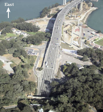 On Yerba Buena Island, there are plans to remove the westbound on-ramp and the
westbound off-ramp located on the eastern side of the island and replace
them with a new westbound on-ramp and a new westbound off-ramp that would
address design standards and traffic safety requirements. This project has
been proposed to address the geometric and operational deficiencies of the
existing westbound on-ramp and existing westbound off-ramp on the eastern
side of Yerba Buena Island and their effects on the San Francisco-Oakland
Bay Bridge (I-80) mainline, without degrading the mainline operation as
compared to the noaction alternative. An EIR was being prepared as of
October 2008. The Yerba Buena Island Ramps Improvement Project is
estimated to cost $113,000,000. Funding is anticipated through the
Proposition 1B Local Bridge Seismic Retrofit Program, Federal Highway
Bridge Replacement and Rehabilitation Program and other local funding
sources. Construction is scheduled to begin in fiscal year 2011/12. There
are two alternatives being considered (in addition to no-build):
On Yerba Buena Island, there are plans to remove the westbound on-ramp and the
westbound off-ramp located on the eastern side of the island and replace
them with a new westbound on-ramp and a new westbound off-ramp that would
address design standards and traffic safety requirements. This project has
been proposed to address the geometric and operational deficiencies of the
existing westbound on-ramp and existing westbound off-ramp on the eastern
side of Yerba Buena Island and their effects on the San Francisco-Oakland
Bay Bridge (I-80) mainline, without degrading the mainline operation as
compared to the noaction alternative. An EIR was being prepared as of
October 2008. The Yerba Buena Island Ramps Improvement Project is
estimated to cost $113,000,000. Funding is anticipated through the
Proposition 1B Local Bridge Seismic Retrofit Program, Federal Highway
Bridge Replacement and Rehabilitation Program and other local funding
sources. Construction is scheduled to begin in fiscal year 2011/12. There
are two alternatives being considered (in addition to no-build):
In May 2012, the CTC approved reconstructing and reconfiguring the westbound on- and off-ramps from I-80 on the new east span of the Oakland Bay Bridge to Yerba Buena Island.
Note that the Yerba Buena Island offramps are closely connected to the East Span Bike Path (see below).
In October 2016, it was reported that drivers heading
westbound on the Bay Bridge will now have new ramps to enter and exit
Yerba Buena/Treasure Island. Two new westbound on and off-ramps on I-80
taking drivers to and from the Bay Bridge and Yerba Buena/Treasure Island
will open on the morning of Saturday, Oct. 22, 2016.Once the new ramps
have been opened, westbound drivers heading toward the island can exit
from the far right lane of the bridge onto the new exit, which is slightly
longer and curving. The current off-ramp, which is located on the bridge's
far left lane will be closed once the new one has opened. Once off the
bridge, drivers can turn right onto Macalla Road to access Treasure Island
or turn left to access Northgate Road to the U.S. Coast Guard facilities
on Yerba Buena Island. Drivers leaving Yerba Buena/Treasure Island and
heading toward San Francisco can get onto the bridge through the new
gently curving on-ramp, which provides a longer, safer distance for
acceleration when merging with highway traffic. Additionally, drivers
heading west on the bridge will still have the option of using the
current, shorter on-ramp on the west side of the island. The current
eastbound on and off-ramps will remain unchanged. Construction on the
Yerba Buena Island East-Side Ramps Project first began in Jan. 2014. The
total project cost $98.04 million.
(Source: KTVU Fox 2 News, 10/15/2016)
Yerba Buena East Off Ramps
In May 2023, it was reported that the last piece of the
massive Bay Bridge reconstruction has opened, almost 10 years after the
main span bearing I-80 began carrying traffic. The new eastbound off-ramp
to Yerba Buena Island will increase access to Treasure Island, where San
Francisco officials hope to develop thousands of new homes, retail and
commercial space, and hotel rooms. City plans have touted Treasure Island
as San Francisco's newest emerging neighborhood. The ramp exits the lower
deck of the Bay Bridge in the far-right lane just past the tunnel. It
replaces an existing eastbound offramp on the far-left lane, which will
stay open for several weeks to give motorists time to adjust. From a
highway design perspective, there is significantly improved geometry from
what it was. Trucks and buses have been known to get stuck in the tight
turns of the existing offramp. The new ramp is better, but still tight.
The original alignment of the ramp was closed almost 20 years ago to
accommodate work on Treasure Island's Southgate Road, which is now
complete. Yerba Buena and Treasure Island are about halfway between San
Francisco and Oakland. The two are commonly confused. Yerba Buena is a
hilly, natural island, while Treasure Island is larger, manmade and flat,
created in the 1930s. Treasure Island was first used as the site of the
Golden Gate International Exposition that opened in 1939. It was converted
to a Navy base during World War II. Most of Yerba Buena Island is a U.S.
Coast Guard station. The islands are linked by a causeway.
(Source: $ Napa Valley Register, 5/2/2023)
In June 2023, it was reported that the left lane exit
from the Bay Bridge to Treasure Island is scheduled to close in late June
2023 and remain shut down for approximately three years, as motorists are
redirected to the newly built exit to Yerba Buena Island that opened in
May 2023. To access the new off-ramp, drivers will need to exit from the
right lane, just past the Yerba Buena Island tunnel on the lower deck of
the bridge, according to Caltrans, which worked on the project in
collaboration with the San Francisco County Transportation Authority, the
Bay Area Toll Authority and the Treasure Island Development Authority. The
goal of the new off-ramp was to reduce congestion of eastbound traffic
across the bridge as transportation authorities retrofit roads that
connect the islands to the bridge. The closure of the old ramp is
scheduled to remain in effect until December 2026 while Caltrans completes
a seismic retrofit of the West Side bridges on Treasure Island.
(Source: SF Gate, 6/22/2023)
Approach to Eastern Span from Yerba Buena Island (~ SF R8.117 to SF R8.278)
 By May 2008, work had begun on Yerba Buena Island on both a temporary bridge
and a temporary bypass (see map on right; click on the image for the original from the SF Chronicle)). The temporary bypass is on the south side of the bridge; it will carry traffic in both directions for three years.
In March 2008, crews installed the first piece of the bypass atop a pair
of those columns. A double-deck steel span will take traffic on a curving
1,200-foot detour just south of the existing bridge. The bypass will
extend from the end of the trestle section of the existing bridge to the
tunnels. It will allow crews to demolish the current link to the island
and build a connection for the new span. The bypass is being built on the
ground, then will be hoisted into the air one piece at a time. The fifth
and final piece will require a weekend bridge closure - possibly over
Labor Day 2009 - as crews cut the existing span and slide it off its
supports on a set of rails erected 150 feet in the sky. Then the new piece
will be lifted onto another set of rails and rolled into place atop the
bridge supports. To the north, a temporary bridge will be constructed.
Workers are planting seven sets of temporary steel towers in the bay and
the eastern end of the island. In June, steel girders arrived from
Washington and were formed into a bridge reaching from near Yerba Buena
Island to the already-completed skyway section of the new eastern span.
This will look like a bridge, and will be a bridge, but won't ever carry
traffic in this form. Instead, it will be used to assemble and support the
28 winglike steel pieces - 14 for eastbound lanes and 14 for westbound -
that will make up the deck of the new Bay Bridge. Those sections will
begin arriving from Shanghai, where the bridge is being manufactured, late
2008 along with the four steel sections of the tower. Once the 525-foot
tower is assembled, a suspension cable will be hung and draped around the
bridge deck. The temporary towers and girders will be removed, and the
bridge will support itself.
By May 2008, work had begun on Yerba Buena Island on both a temporary bridge
and a temporary bypass (see map on right; click on the image for the original from the SF Chronicle)). The temporary bypass is on the south side of the bridge; it will carry traffic in both directions for three years.
In March 2008, crews installed the first piece of the bypass atop a pair
of those columns. A double-deck steel span will take traffic on a curving
1,200-foot detour just south of the existing bridge. The bypass will
extend from the end of the trestle section of the existing bridge to the
tunnels. It will allow crews to demolish the current link to the island
and build a connection for the new span. The bypass is being built on the
ground, then will be hoisted into the air one piece at a time. The fifth
and final piece will require a weekend bridge closure - possibly over
Labor Day 2009 - as crews cut the existing span and slide it off its
supports on a set of rails erected 150 feet in the sky. Then the new piece
will be lifted onto another set of rails and rolled into place atop the
bridge supports. To the north, a temporary bridge will be constructed.
Workers are planting seven sets of temporary steel towers in the bay and
the eastern end of the island. In June, steel girders arrived from
Washington and were formed into a bridge reaching from near Yerba Buena
Island to the already-completed skyway section of the new eastern span.
This will look like a bridge, and will be a bridge, but won't ever carry
traffic in this form. Instead, it will be used to assemble and support the
28 winglike steel pieces - 14 for eastbound lanes and 14 for westbound -
that will make up the deck of the new Bay Bridge. Those sections will
begin arriving from Shanghai, where the bridge is being manufactured, late
2008 along with the four steel sections of the tower. Once the 525-foot
tower is assembled, a suspension cable will be hung and draped around the
bridge deck. The temporary towers and girders will be removed, and the
bridge will support itself.
(Source: SF Chronicle, May 28, 2008)
In August 2008, Caltrans released a bid to construct bridges, roadway and install electrical systems in the City and County of San Francisco from the Yerba Buena Tunnel to 0.6 km East of Yerba Buena Tunnel. This likely includes reconfiguration of the interchange and replacement of the original US 40/US 50 tunnel.
Yerba Buena Island / Treasure Island Tolls
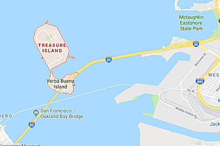 In September 2018, it was reported that -- starting in
2021 -- drivers travelling to or from Treasure Island will be forced to
pay a toll in addition to the tolls they already pay to cross the Bay
Bridge, according to the San Francisco County Transportation Authority.
With numerous new housing developments already under construction, the
island’s population is expected to increase in the coming decades
from less than two thousand people today to an estimated 25,000 residents
by 2035. The first of the new homes will be available in 2021, and SFCTA
wants to have the toll in place “from day one,” said Rachel
Hiatt, a transportation planner with the agency. Drivers will be charged
in both directions, entering and leaving the island. On weekdays the toll
will be $3.50 during peak hours and $2 off-peak. On weekends the price
will drop to $1 during peak hours and free during off-peak. To compensate
for the toll already paid by drivers coming from Oakland, trips to
Treasure Island from Oakland only will be discounted by half. Toll
collection will be automated using FastPass and license plate scanners,
with no toll booths. Drivers without FastPass will be charged an extra $1.
The toll and the addition of paid parking on the island are intended to
discourage driving during congested times and avoid gridlock, Hiatt said.
The money they raise will be used to help subsidize a new ferry service
linking the island to the San Francisco Ferry Building and new AC Transit
bus lines connecting Treasure Island to downtown Oakland, which is
expected to cost roughly $6 million each year to operate. Until the toll
and parking fees can cover the operating costs, developers will subsidize
up to $4 million a year, Hiatt said. The toll system will cost $10 million
to build, half of which will be covered by a federal grant. Residents who
lived on Treasure Island prior to 2011 and all current residents in below
market rate housing there will receive one free daily round-trip toll
until 2026. Below-market rate residents will also receive a round-trip
toll credit for every 20 one-way trips they take to or from Treasure
Island by bus or ferry using a transit pass.
In September 2018, it was reported that -- starting in
2021 -- drivers travelling to or from Treasure Island will be forced to
pay a toll in addition to the tolls they already pay to cross the Bay
Bridge, according to the San Francisco County Transportation Authority.
With numerous new housing developments already under construction, the
island’s population is expected to increase in the coming decades
from less than two thousand people today to an estimated 25,000 residents
by 2035. The first of the new homes will be available in 2021, and SFCTA
wants to have the toll in place “from day one,” said Rachel
Hiatt, a transportation planner with the agency. Drivers will be charged
in both directions, entering and leaving the island. On weekdays the toll
will be $3.50 during peak hours and $2 off-peak. On weekends the price
will drop to $1 during peak hours and free during off-peak. To compensate
for the toll already paid by drivers coming from Oakland, trips to
Treasure Island from Oakland only will be discounted by half. Toll
collection will be automated using FastPass and license plate scanners,
with no toll booths. Drivers without FastPass will be charged an extra $1.
The toll and the addition of paid parking on the island are intended to
discourage driving during congested times and avoid gridlock, Hiatt said.
The money they raise will be used to help subsidize a new ferry service
linking the island to the San Francisco Ferry Building and new AC Transit
bus lines connecting Treasure Island to downtown Oakland, which is
expected to cost roughly $6 million each year to operate. Until the toll
and parking fees can cover the operating costs, developers will subsidize
up to $4 million a year, Hiatt said. The toll system will cost $10 million
to build, half of which will be covered by a federal grant. Residents who
lived on Treasure Island prior to 2011 and all current residents in below
market rate housing there will receive one free daily round-trip toll
until 2026. Below-market rate residents will also receive a round-trip
toll credit for every 20 one-way trips they take to or from Treasure
Island by bus or ferry using a transit pass.
(Source: SF Examiner, 9/19/2018)
In December 2018, it was reported that a vote to charge
vehicles a toll for entering and exiting Treasure Island was put on hold
after island residents protested, saying it would hurt them financially.
Residents who spoke at a hearing in early December 2018 said that for a
community with only limited services – just a single grocery store,
no pharmacy, no gas station and no public schools – adding
additional barriers to entering and leaving the island would impose an
unfair burden. The San Francisco County Transportation Authority held
seven outreach events on the island between Sept. 9 and Nov. 27, but
during public comment many residents said news of the proposed toll had
taken them by surprise. Treasure Island is home to 600 households today,
but that number is expected to climb to 8,000 households by 2035 with the
planned construction of new housing developments. The toll, which
wouldn’t start until 2021, is intended to alleviate additional
congestion on the Bay Bridge and to pay for a new ferry service and AC
transit line coming to the island. The plan calls for current Treasure
Island households to receive a monthly $300 stipend for five years to help
offset the additional costs, which would be the cash equivalent of making
two round-trip journeys to the San Francisco mainland every weekday. But
even with the stipend, many residents weren’t happy with the
proposal. Several supervisors seemed to agree. The board will take up the
matter again after several newly elected supervisors take their seats in
January. A meeting date has not been set.
(Source: SF Examiner, 12/11/2018)
In November 2019, it was reported that the Treasure
Island Mobility Management Agency Committee on Tuesday approved an
exemption from a future congestion pricing toll for some 1,800 current
Treasure Island residents. The benefit has been expanded so that current
residents will not have to pay a toll of up to $3.50 for trips to the
island until the first 4,000 units of a planned 8,000 unit development
project on the island are constructed. The estimated date for the
units’ completion is 2029. The proposed exemption must still be
approved by the agency’s full board.
(Source: SF Examiner, 11/12/2019)
Temporary Constructions
In order to build the suspension bridge, a large amount of temporary construction is required. These include steel trusses starting to cross San Francisco Bay between Yerba Buena Island to the west and the new 1.2-mile-long precast concrete Skyway to the east, alongside the existing eastern steel truss span of the old Bay Bridge. The truss bridge must support the 28 steel-deck sections being fabricated in China. In addition to falsework for the SAS span, part of a $1.4-billion contract held by a joint venture of American Bridge Inc., Coroapolis, Pa., and Fluor Enterprises Inc., Aliso Viejo, Calif. Rancho Cordova, Calif.-based C.C. Myers Inc. will demolish and replace a 300-ft-long double-deck section of transition bridge over one weekend later this year. The 1.2-mile Skyway portion of the east span is just completed, and a $429-million seismic reconstruction of the west approach wrapped up in early 2009. Construction feats as of early 2009 include a 1,700-ton, 150-ft megapick of a steel-tub girder in 11 hours, a 2,100-ton steel foundation box for the 525-ft-tall single tower and a Labor Day lift-out of a 6,500-ton section of roadway. Later in the year, a custom-built crane from China will arrive with a 328-ft-long boom and the capacity to lift 1,700 metric tons. Even the barge had to be custom-built: it is 400 feet long, 100 feet wide and 22 feet deep.
Eastern Span Tunnel Approach Replacement
![[Replacement of Roadway]](images/080-bay-bridge.replacement.jpg) The construction technique used is interesting. Portions of the replacement roadway are constructed
to the side of the bridge. The bridge is then closed, the old roadway
demolished, and the new roadway rolled into place. This is illustrated to
the right. It was done over Labor Day Weekend 2007, when at 8 p.m. Aug.
31, after the last Friday commute stragglers passed, Caltrans took the
unprecedented step of completely closing the San Francisco-Oakland Bay
Bridge for 3½ days and nights of major reconstruction. Crews then
demolished a 100-yard bridge section just east of the Yerba Buena Island
tunnel. Once the demolition was done and the rubble carted away, the new
section was be rolled on seven rails into place, controlled by a computer.
The 6,500-ton, five-lane section had already been constructed on the
island adjacent to the bridge deck. The new piece was be jacked a few
inches higher than the existing roadbed, and when it was in place, it was
lowered onto new concrete supports. There was only 3 inches of clearance
where the new deck met the existing deck. Unlike the old deck, the new one
was designed with equal-length columns, sitting on top of pilings that are
encased in an isolation base, surrounded by a few inches of open space in
a concrete housing. This allows them to move side to side in an
earthquake, hopefully without damage. The bridge reopened before 5:00am
Tuesday for the return-to-work commute.
The construction technique used is interesting. Portions of the replacement roadway are constructed
to the side of the bridge. The bridge is then closed, the old roadway
demolished, and the new roadway rolled into place. This is illustrated to
the right. It was done over Labor Day Weekend 2007, when at 8 p.m. Aug.
31, after the last Friday commute stragglers passed, Caltrans took the
unprecedented step of completely closing the San Francisco-Oakland Bay
Bridge for 3½ days and nights of major reconstruction. Crews then
demolished a 100-yard bridge section just east of the Yerba Buena Island
tunnel. Once the demolition was done and the rubble carted away, the new
section was be rolled on seven rails into place, controlled by a computer.
The 6,500-ton, five-lane section had already been constructed on the
island adjacent to the bridge deck. The new piece was be jacked a few
inches higher than the existing roadbed, and when it was in place, it was
lowered onto new concrete supports. There was only 3 inches of clearance
where the new deck met the existing deck. Unlike the old deck, the new one
was designed with equal-length columns, sitting on top of pilings that are
encased in an isolation base, surrounded by a few inches of open space in
a concrete housing. This allows them to move side to side in an
earthquake, hopefully without damage. The bridge reopened before 5:00am
Tuesday for the return-to-work commute.
In September 2009, the Bay Bridge closed to traffic to permit a complex construction maneuver 150 feet in the air. Specifically, over this weekend, workers cut a portion of the existing eastern span near Yerba Buena Island and slid it out. They rolled in a new section, rerouting traffic (via an S-curve) onto a temporary bypass for three to four years. Once the temporary bypass is completed, speeds will be limited to 40 mph, 10 mph below the current limit. Crews will demolish the existing tunnel approach and build a connection to the new bridge. This seems similar to what was done on the other end of the span. Note that during this construction some problems were found, necessistating closure of the Bay Bridge for a few days while they were repaired. This happened again in November 2009.
![[S-Curve]](maps/080-s-curve.jpg) In October 2009, Caltrans begin installing more prominent warning signs near the Bay Bridge's recently
opened S-curve to try to force drivers to slow down in the aftermath of a
messy big-rig crash on the new stretch in early October that tied up
westbound traffic for hours. State officials had already approved a plan
to step up warnings to motorists that the speed limit on the S-curve is 40
mph, down from 50 mph on the rest of the span. One change will be
radar-activated signs that alert drivers to their real-time speed along
with the posted limit, to be in place by the end of October 2009. On the
lower deck, Caltrans will install a large, yellow "40 mph" sign with a
curved arrow, replacing the sign that had designated the now-closed Yerba
Buena Island exit. If that doesn't do the trick, Caltrans may install
reflective bumps on the pavement, known as "rumble strips," before the
S-curve. Besides the warnings, Caltrans is planning to treat the metal
panels at the beginning and the end of the curve with a mixture of epoxy
and sand to improve traction. As of 11/9, there have been more than 42
accidents in the curved area since it opened Sept. 8 as part of the
eastern span replacement project. On 11/9, the first fatal accident
occurred when a big rig plunged 200 feet off the Bay Bridge, killing the
driver and obliterating the truck. The truck was carrying a load of pears
to San Francisco when the crash occurred about 3:30 a.m. that morning. The
impact shattered the truck into pieces. Metal debris and boxes of pears
littered the landing where the truck crashed. A mattress, presumably from
the truck's cab, hung on a railing 200 feet above. The CHP said the truck
driver lost control on the curve, possibly because he was traveling about
50 mph, about 10 mph above the posted speed limit.
In October 2009, Caltrans begin installing more prominent warning signs near the Bay Bridge's recently
opened S-curve to try to force drivers to slow down in the aftermath of a
messy big-rig crash on the new stretch in early October that tied up
westbound traffic for hours. State officials had already approved a plan
to step up warnings to motorists that the speed limit on the S-curve is 40
mph, down from 50 mph on the rest of the span. One change will be
radar-activated signs that alert drivers to their real-time speed along
with the posted limit, to be in place by the end of October 2009. On the
lower deck, Caltrans will install a large, yellow "40 mph" sign with a
curved arrow, replacing the sign that had designated the now-closed Yerba
Buena Island exit. If that doesn't do the trick, Caltrans may install
reflective bumps on the pavement, known as "rumble strips," before the
S-curve. Besides the warnings, Caltrans is planning to treat the metal
panels at the beginning and the end of the curve with a mixture of epoxy
and sand to improve traction. As of 11/9, there have been more than 42
accidents in the curved area since it opened Sept. 8 as part of the
eastern span replacement project. On 11/9, the first fatal accident
occurred when a big rig plunged 200 feet off the Bay Bridge, killing the
driver and obliterating the truck. The truck was carrying a load of pears
to San Francisco when the crash occurred about 3:30 a.m. that morning. The
impact shattered the truck into pieces. Metal debris and boxes of pears
littered the landing where the truck crashed. A mattress, presumably from
the truck's cab, hung on a railing 200 feet above. The CHP said the truck
driver lost control on the curve, possibly because he was traveling about
50 mph, about 10 mph above the posted speed limit.
(Source: SJMN 11/10/2009)
In May 2010, it was reported that, by July 2010, the additional CHP patrols of the S-curve would be eliminated. After the crash described above, safety measures such as flashing lights, reduced speed signs, and reflective tape were installed. In late April 2010, rumble strips and underground speed sensors were installed. The sensors allow officials to monitor traffic speeds in real time, and patrols can be deployed as needed instead of constantly monitoring the bridge.
Eastern Span Oakland-Bay Bridge (~ SF R8.237 to ALA 2.345)
Eastern Span Construction Notes
There is work afoot on the Oakland-Bay Bridge. According to Tollroadnews, the new east span of the San Francisco-Oakland Bay Bridge is already estimated to cost $3.4b with the price anticipated to rise with bids on the cable stayed or anchored suspension section. The East Span, a doubledecker of 5-lanes on top of 5-lanes was built by the California Toll Bridge Authority and opened in 1936. During the Loma Prieta earthquake of 1989, the bolts on the upper deck of one truss section sheered off and that deck section hinged down onto the lower deck closing the whole bridge for several weeks. Several of the main piers are weakened. Most are on wooden deep piles which are rotting. There was general agreement it was best to build a new span. But the agreement ended when it came to the design of the bridge. The cost has been going up, and there has been endless infighting on who will pay for what. It has gotten worse and worse. According to the Oakland Tribune, the most complete estimate as of January 2005 for the full cost to build, engineer and oversee construction of the new eastern span of the Bay Bridge: $5.9 billion. The skyway is costing $160,000 per foot. Extending it could cost $460,000 per foot. There are all sorts of accusations flying around about whether Caltrans hid the cost. For example, starting in August 2002, a consultant's mock bid placed the cost of the remaining tower at $934 million. By December 2003, Caltrans' own bridge cost specialist placed the bid at $1 billion and revised it to $1.3 billion in April. All the while, the agency stuck to its official figure of $780 million. The bid price May 26 was $1.4 billion. Currently, information on the Bay Bridge project may be found on the frontpage of the Caltrans Website. In July 2005, final agreement was reached. On July 18, 2005, Gov. Arnold Schwarzenegger signed legislation allowing construction to resume on a self-anchored suspension span to complete the new eastern portion of the bridge. The legislation calls for the state to contribute an additional $630 million to help cover the $3.6 billion in cost overruns on the new eastern span. Motorists will have to start paying a $1 extra in 2007 on all toll bridges in the Bay Area except for the Golden Gate to cover much of the rest of the cost of the $6.3 billion project. The increase will mean $4 bridge tolls.
(Note: To compare with the original construction: In the early 1930s, California designed and built the 8-mile Bay Bridge -- west and east spans linked by the world's biggest bore tunnel -- in a mere 5½ years. And workers did it ahead of schedule and for $78 million, well under budget. The replacement span took more than twice as long to construct, and the price tag -- $6.4 billion -- is 4½ times higher than engineers estimated. The entire 1936 crossing cost $30,000 a foot in adjusted 2013 dollars while the shorter new span is setting back taxpayers $550,000 per foot. In the 1930s, 24 men died building the original bridge; none has perished on the new span. In the 1930s, Bay Bridge Chief Engineer Charles Purcell didn't need four years and $155 million for an environmental impact study. And 1930s-era politicians had little or no formal say about how the bridge would look.)
(Source: Contra Costa Times, 8/10/13)
In late March 2006, it was reported that Caltrans received two bids to build the single-tower suspension span to complete the bridge, and the low offer was $1.43 billion, slightly less than estimated. The low bid comes from a joint venture between American Bridge Co. and Fluor Corp. of Coraopolis, Pa. Caltrans engineers had estimated the cost at $1.45 billion. The second bid, $1.68 billion, was from a joint venture between contractors Kiewit and Manson, two of the three companies in the consortium building the concrete skyway section of the bridge, and Koch and Skanska. Caltrans officials then began reviewing the bids, checking figures, examining lists of subcontractors and making sure the details match the agency's requirements. If all goes well, the contract would be offered to American Bridge/Fluor. If the low bid is determined to be flawed, Caltrans could either accept the higher offer or reject both bids and start over. Construction activity on the Bay Bridge probably won't be visible until mid-to-late 2007. The new eastern part of the Bay Bridge will be the world's largest self-anchored suspension span. The bridge is expected to open to westbound traffic in spring of 2012 with eastbound lanes opening about a year later. The state has two additional contracts to award on the bridge: one for the Oakland touchdown ramps, and a second to build connector lanes to Yerba Buena Island.
In early 2009, it was reported that work on the Eastern span was delayed, due to problematic welds. Specifically, according to Caltrans records, inspectors hired by Caltrans to monitor the fabrication of steel girders that will support the tower's roadway reported finding cracked welds in 2008. Caltrans and others in charge of the bridge construction say the welds are safe and that fixes have been made - but also say the inspectors interpreted the welding standards too rigidly. Meanwhile, the inspection outfit that sounded the alarm has since been replaced. The welds in question are contained in 900 bridge panels that are being assembled into football field-size deck sections that will stretch across the 1,800-foot-long tower portion. The sections were supposed to have begun arriving from China in October 2008, but due to delays they weren't expected to arrive until at least April 2009. The panels are being made by the Zhenhua Port Machinery Co. of Shanghai, which is fabricating most of the steel for the $1.4 billion signature tower on behalf of the span's joint-venture builder, American Bridge-Fluor Enterprises. ZPMC, as the company is commonly known, is the same firm that built the mammoth cranes that tower over the Port of Oakland - indeed, it builds 80 percent of the container cranes used around the world. Soon after ZPMC started production in late 2007, however, the inspectors hired by Caltrans began finding problems - specifically, an unacceptably large number of welding flaws in the new panels. Specifically, as many as 65% of the more than 30 welded panel sections examined - either visually or using ultrasonic testing - failed to meet specifications. The memos also reveal that the inspectors questioned ZPMC's ability to handle the complex bridge construction job - and that they were frustrated by Caltrans officials' demands that the project proceed despite the allegedly substandard welds. Caltrans officials, working with ZPMC and MacTec inspectors, say they eventually worked out a program to tag and repair all the bad welds. But e-mails from inspectors show problems persisted. After consulting with a structural steel expert from Lehigh University in Pennsylvania, Caltrans officials concluded the decks will be safe, and that the earlier problems were the result of strict weld standards that essentially allowed for no cracks. In other words, a few minor cracks are OK.
In May 2009, a group of about 70 architects pronounced
the new east span of the Bay Bride "a beautiful landmark emerging from the
morass of political and bureaucratic ugliness that has defined its
creation." The architects used the terms "beautiful," "sleek" and
"elegant" to describe the $6.3 billion new span, expected to open in 2013.
Some of the highlights included the bicycle and pedestrian path, the steel
structures on the underside of the new skyway to provide homes for
cormorants, and the plans to illuminate the 525-foot tower and the cables
supporting the new suspension span.
(San Francisco Chronicle)
In July 2010, it was reported that a committee of the Bay Area Toll Authority approved funding bridge engineering firm T.Y. Lin $1 million to design a system of dampers that could be installed on the cantilever-style portion of the current east span to reduce the vibrations caused by wind and the relentless pounding of traffic. T.Y. Lin, which analyzed the failure of the cracked eyebar discovered over Labor Day weekend in 2009, and Caltrans engineers determined that vibrations caused by wind led to both the initial failure of the eyebar, which is a key structural piece, as well as the collapse of the repair job that flung tons of steel to the bridge's upper deck in October. The firm will also design, but not construct, a device that could be quickly fabricated and installed should another eyebar crack. Even though no additional cracks have been discovered, the potential always exists. To further reduce risk, bridge officials want to install dampers - devices that reduce vibrations - on some of the most flexible of the 16 diagonal arrays of eyebars on the east span's trestle section. T.Y. Lin will determine how and where the dampers would be most effectively placed, and estimate the cost. The authority, which is expected to approve the plan on July 28, 2010, would then seek a contractor to provide and install the dampers.
In March 2010, it was reported that there are efforts
to pick up the construction pace on the east span of the Bay Bridge, as
evidenced by the steel deck pieces from China finally being lifted into
place off Yerba Buena Island in early March. However, delays at the
Chinese steel fabrication plant and a Canadian drafting firm have put the
bridge 15 months behind schedule, and catching up could be difficult. It
is rumored that incentives are being offered to speed the the production
of the final two steel deck segments, which link the suspension span with
the completed skyway section of the new bridge and support the suspension
cable on the east end. There have also been difficulties with completing
the construction drawings for the final two roadway sections in Vancouver,
British Columbia. Fabrication of the pieces will be far more complex than
producing the other deck segments, he said, because they connect the
suspension span and skyway, will anchor the cable that supports the span,
and are curved and slightly banked. They also weigh 1,500 tons - three
times the average deck piece.
(Source: "Push to build 2 crucial Bay Bridge parts faster", SF Chronicle, 3/10/2010)
In June 2010, it was reported that the Eastern Span is
beginning to take shape. In June 2010, the first five pieces of the
525-foot steel tower left the ZPMC steel fabrication plant in Shanghai to
begin their transpacific journey. They're expected to arrive in the Bay
Area by July 2010. The first tower pieces, once they arrive, will be
inspected, taken to the construction site on barges, and tipped into place
on a concrete tower foundation that sits in the bay. The 250-foot-tall
steel segments, which comprise the lower level of the tower, will be
slipped atop 150 steel dowels that stick out of the foundation and will be
fastened down with 424 large anchor bolts. About 150 feet above the
foundation, the new single-tower suspension span already is coming
together. Crews have installed the wing-shaped boxes that will make up the
bridge deck atop the temporary trestles that hold them in place and
stretch from Yerba Buena Island to the already completed skyway section.
The deck pieces, the first two shipments of steel from China, are among 28
that will be lowered into place by the huge Left Coast Lifter barge crane
then joined together, with large crossbeams connecting the side-by-side
decks. The deck and the tower will be completed over the next two years.
The cable will be installed - anchored on the east end of the suspension
span, strung across the tower, looped around the west end, back across the
tower, then anchored again on the east end- and the temporary trestles
will be removed, leaving the span essentially cradled by the suspension
cable. The current plans as of June 2010, which are about a year behind
schedule, call for the westbound lanes to be completed first - in April
2013 - with the eastbound lane opening in December 2013. Because of the
configuration of the new bridge and its connection to the toll plaza, part
of the existing bridge has to be razed to make way for Oakland-bound
traffic.
(Source: San Francisco Chronicle, 6/21/10)
In August 2010, a reporter toured the 'abuildin' bridge, in particular the the aspects of construction visible from the hollow core that extends the length of the skyway. It's a space roughly 15 feet high and 85 feet wide, a ghostly gray tunnel that shrinks to 4 feet in height when you move from one 225-foot-long section to the next. Stretched into the dark void is a metal catwalk of sorts, with a trough for cables and utility wires underneath. The bridge is designed so that it will ride out even the largest earthquake that might hit the region, someday. One example: horizontal steel "hinge pipe beams" 6 feet in diameter and 60 feet long to reinforce the viaduct at six points along the way. They're there to absorb lateral movement that otherwise might stress individual sections during a major temblor.
In December 2010, it was reported that a new approach will permit opening of the new east span to drivers traveling in both directions by the end of 2013 instead of the earlier plan to make eastbound motorists wait until 2014. This new approach will required a series of reconfigurations so that a portion of the incline section can be cut away to make way for construction of the eastbound landing of the new bridge. Those reconfigurations will bring changes in the alignments of the westbound approach to the existing bridge as well as the eastbound landing, both of which will take a turn to the south. The new eastbound alignment will probably premiere in May or June. The westbound change, which will include a temporary span, is likely to come at the end of 2011. The accelerated timeline comes after bridge officials offered a package of incentives to speed fabrication of the bridge's steel deck and tower segments in China. The steel deliveries have arrived on time or ahead of schedule. The increased speed of the steel deliveries, combined with the changes on the east end of the bridge, will enable the span to open in December 2013. The approach taken shifts everything to the south to make way for the eastbound landing of the new bridge to be built sooner than 2014. Some lane closures, and potentially a one-direction bridge closure, will be necessary. Crews are relocating utilities to accommodate the traffic changes that will begin in 2011. Early in 2011, access roads used by Caltrans crews and construction workers will be moved to the south. In May or June 2011, the eastbound lanes of traffic, after they come off the existing Bay Bridge, will also weave to the south. That will make way for crews to widen the incline section of the old bridge so a segment that blocks construction of the new landing can be cut away. Once traffic is shifted onto that temporary span, again, curving south, construction of the eastbound landing, officially known as the "Oakland touchdown," can commence.
In March 2011, it was reported that the cost of
completing the Bay Bridge early was about $106 million. This was due to a
pair of cost increases - one on the Oakland touchdown of the bridge, the
other on the connection to the Yerba Buena Island tunnels - that will
allow both directions of the $6.3 billion span to open to traffic at the
same time in 2013. The cost increases will be paid for out of the
project's contingency fund, a pot of money set aside to cover cost
overruns, unanticipated expenses or major changes or additions. The
expenses will eat up a little more than half of the estimated $200 million
remaining in the contingency fund.
(Source: SF Chronicle, 3/9/11)
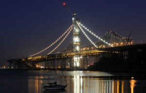 In August 2011, it was reported that construction lights have been turned on,
illuminating the eventual outline of the bridge; specifically, there are
about 100 large lights attached to the steep catwalks that will be used to
install a giant cable over the top of the 525-foot-tall bridge tower. The
four orange metal mesh catwalks are temporary but they mirror the route
for stringing the bridge cable. Contractors are doing preparation work to
begin installing a thick mile-long cable that will wrap up and over the
tower twice before being anchored into the bridge deck to hold up the
structure. Crews must do much of the cable work at night to avoid the sun
that can heat up and expand parts of the huge cable, making it difficult
to measure and tension during installation.
In August 2011, it was reported that construction lights have been turned on,
illuminating the eventual outline of the bridge; specifically, there are
about 100 large lights attached to the steep catwalks that will be used to
install a giant cable over the top of the 525-foot-tall bridge tower. The
four orange metal mesh catwalks are temporary but they mirror the route
for stringing the bridge cable. Contractors are doing preparation work to
begin installing a thick mile-long cable that will wrap up and over the
tower twice before being anchored into the bridge deck to hold up the
structure. Crews must do much of the cable work at night to avoid the sun
that can heat up and expand parts of the huge cable, making it difficult
to measure and tension during installation.
(Source: Mercury News)
In October 2011, it was reported that contractors installed the last deck segment for the suspension span. The 1,049-ton steel box gives the east span a nearly continuous surface from Oakland to Yerba Buena Island. Installing the 28th and last piece of the 2,007-foot bridge deck allows contractors to start stringing cable up and over a 525-foot tall bridge tower, starting in December 2011. This segment is the place where the cable actually comes in and locks into the bridge; specifically, the segment has a big hole where will the cable will go down and anchor.
In November 2011, questions arose about the structural
inspections of the Bay Bridge. In early November, Caltrans officials fired
two employees after an investigation questioned the validity of structural
integrity testing performed on the Bay Bridge tower by a technician who
had falsified results on three other Caltrans construction projects. In
response, Caltrans has decided to have its seismic safety review panel, an
expert panel of structural engineers and academics, examine records of the
inspections, which Caltrans defended. A UC Berkeley civil engineering
professor agreed with their assessment, saying that it seemed unlikely
that the technician allowed inferior work on the $6.3 billion Bay Bridge
east span to pass the test, and that even if he had, the bridge was
designed with additional support devices–or redundancies–to
ensure its safety. A report in the Sacramento Bee said there was no
evidence that the technician falsified Bay Bridge results but said he
routinely used test devices without verifying their accuracy.
(Source: SF Chronicle, 11/15/11)
In December 2011, work commenced on the installation of
the the steel cable that will hold up the new eastern span of the Bay
Bridge. The cable is 2.6 feet in diameter and nearly a mile long. It
weighs 5,291 tons, or nearly 10.6 million pounds, and is made up of 137
steel strands, each one composed of 127 steel wires. Each wire is strong
enough to hold up a large automobile. The cable will travel from the
Oakland side of the span to the San Francisco side and back again. The
2,047-foot self-anchored suspension span will be the longest of its kind
in the world. To install the cable, crews lifted a giant spool of steel
strands from a barge onto the deck of the new span. Crews will anchor one
end of each strand on the Oakland side of the span, underneath the deck.
Using machinery that looks like a ski lift, they will then thread the
strands along the path of bright orange catwalks that have been attached
to the new tower for several months. The strands will go up to the top of
the center tower and down to the San Francisco side of the span, where
they will be looped underneath the deck of the bridge, then threaded back
up to the tower and back down to the Oakland side of the bridge. There,
crews will anchor the other end of the strands. It will take a few months
to complete the installation. Once all the strands are installed, crews
will bind them together and coat them with zinc paste. As with most of the
steel on the bridge, the cable was made in China. It was manufactured by
Shanghai Pujiang Cable Co. at a cost of $28 million.
(Source: The Bay Citizen)
In December 2012, it was reported that "the big lift"
was completed. This was the complicated task of shifting the 35,200-ton
weight of the new single-tower suspension span from temporary trestles
that supported it from below to a single mile-long cable, draped across a
525-foot tower and anchored in the bridge deck that holds it from above.
The lifting work, officially known as a load transfer, started in
mid-August 2012 when crews from American Bridge/Fluor, the joint venture
building the self-anchored suspension segment of the new $6.3 billion
bridge, began using dozens of hydraulic jacks to gradually adjust the
tension on 200 suspender cables that connect the decks of the bridge to
the suspension cable. This involved tuning the bridge like a giant
stringed instrument, resulting in the twin steel decks rising about 18
inches from the rusted trestles that have supported them for years. At the
same time, the main cable moved about 30 feet out and 16 feet down. Crews
are next coating the suspension cable -- 17,399 pencil-thick strands of
compressed steel wire -- with zinc paste, wrapping it with steel wire then
applying a thick coat of paint to make sure it withstands the elements.
Next will be the process of "locking down" the span, connecting it to the
concrete skyway segment of the bridge with special pipe-like seismic
joints. Crews have already started to remove parts of the trestle beneath
the bridge, though that work will proceed intermittently. It is
anticipated that by Spring 2013, workers will begin to take down the
scaffolding surrounding the span's gleaming white tower.
(Source: SFGate.Com, 11/21/2012)
In March 2013, it was reported that Caltrans made the final concrete pour on the eastern span of the Bay Bridge.
Over Labor Day weekend 2013, traffic on the Bay Bridge was shut down, and the approaches reworked to open the new Bay Bridge. The last car across the bridge belonged to Bob Faber, whose gold and brown Model A had been recruited to be the ceremonial last car to cross. As soon as Faber and his CHP and Caltrans escorts passed through the plaza, toll collectors abandoned their booths and the electronic signs above them all changed to read "closed." Construction crews that had assembled near the toll plaza immediately rolled into action, some heading out onto the old bridge, others starting to grind down the pavement, removing the old toll plaza strips and clearing a path for the new alignment to the new bridge.
East Span Bike Path (Oakland to Yerba Buena Island)
In August 2011, the CTC approved $3,249,000 in SHOPP funding to onstruct 0.8 mile of bicycle/pedestrian facility in Oakland, from 0.3 mile west to 0.5 mile east of the San Francisco/Oakland Bay Bridge Toll Plaza to provide a critical connection from the new San Francisco-Oakland Bay Bridge (SFOBB) East Span to the local and regional bikeway system and to comply with the Bay Conservation and Development Commission (BCDC) permit.
In June 2016, it was reported that a committee tasked
with overseeing seismic retrofit work on the Bay Bridge approved $6.3
million in additional changes to the bridge's pedestrian and bike path.
The changes are the latest in a series of difficulties for the path, which
has already seen more than $24 million in cost overruns for redesigns,
adjustments and repairs to the railing, including $13.5 million in work on
railing that had been previously installed, according to Caltrans
documents. Of the most recent changes, aesthetic considerations on the
bike path contributed $2.5 million in costs and will be used to change the
architecture plan from a truss to a cantilever support system. Another
$3.8 million will be used to address construction and aesthetic issues
with the fabrication and installation of the railing, according to
Caltrans documents. The cost also includes adding an access control gate
and extending the railing at one location. Two-thirds of the pedestrian
and bike path opened to the public in September 2013, allowing visitors to
traverse just west of the bridge's signature tower, but for the past two
and a half years, it has stopped short of Yerba Buena Island. The Bay Area
Toll Authority Oversight Committee voted last week to contribute $1
million to enter into a funding agreement with the San Francisco County
Transportation Authority, which also contributed $1 million, to construct
a "temporary" landing for the Bay Bridge's pedestrian and bicycle path.
The temporary landing is expected to be completed in the fall, said toll
authority spokesman John Goodwin. A permanent landing could be years away
while the toll authority, along with the San Francisco County
Transportation Authority, considers a plan to extend the bike path from
Yerba Buena Island into San Francisco.
(Source: East Bay Times, 6/16/2016)
In August 2016, it was reported that the opening of the
Bay Bridge eastern span bike path connector to Yerba Buena Island is being
delayed until mid-October 2016 — this time because the landing area
is still a mess. As recently as May 2016, Caltrans officials said they
expected to finally connect the 2.2-mile path from Oakland by September.
In August, however, a Bay Bridge oversight panel decided construction
crews needed more time to grade, pave and stripe the road where the bike
path will touch down. Crews are also building a parking lot on Yerba Buena
for bicyclists who choose to park their cars on the island and peddle east
across the span. The path originally was supposed to be completed in fall
2014, a year after the eastern span opened to cars. But some work
couldn’t be started until demolition workers took down the old
eastern span, and subsequent questions about the safety rail, the
path’s observation platform and even winter rains have been blamed
for the sluggish construction of the final leg.
(Source: SFGate, 8/23/2016)
In October 2016, it was reported that the bicycle and
pedestrian path across the eastern span of the Bay Bridge is done;
however, the path from Oakland to Yerba Buena Island would not be opened
until crews complete a few finishing touches on the island side of the
route. The Bay Bridge Trail, as the cycling/walking path is formally
known, opened in September 2013, immediately after the eastern span opened
to motor vehicles. The path has been open past the eastern span’s
suspension tower, about 2.5 miles west of the Bay Bridge Toll Plaza but a
few hundred yards short of Yerba Buena Island. Construction delays and
design tweaks have held up the path’s opening, which Caltrans
initially scheduled for 2014. However, the trail’s Yerba Buena
Island landing point is in the middle of a busy construction zone, with
crews working on new ramps for traffic onto and off of the bridge. To
complicate matters, the surface streets at which the path ends are narrow
and steep. Cyclists who venture down Hillcrest Road, which leads to
Treasure Island, can count on encountering traffic bound to or from the
bridge. To improve the odds that path users will have that positive
experience, the S.F. County Transportation Authority has built a temporary
vista point, complete with bike racks, restrooms and water fountains,
adjacent to an old Navy residence just to the southwest of the
trail’s western end. SFCTA spokesman Eric Young that work on
preparing the short route from the path to the vista point, which includes
a 12-foot-wide crosswalk across Southgate Road and new directional and
advisory signage, is nearly complete. The vista facility, which will look
east and southeast over the Oakland waterfront, is expected to open by
mid-November. The bike path is expected to be open by then (actually, it
opened at the end of October, 2016).
(Source: KQED, 10/11/2016)
In May 2017, it was reported that in early May 2017,
the 2.2-mile path along the eastern span of the Bay Bridge will open
during weekdays. After three years of stopping a mere 525 feet shy of
Yerba Buena Island, the path was finally completed in October, but it was
only accessible on weekends while Caltrans disassembled the remaining
portion of the old Bay Bridge. Path users will also be greeted with a new
$2 million vista point where the path touches down on Yerba Buena Island.
The landing pad is outfitted with restrooms, benches, a bike rack and a
water fountain, said Eric Young, a spokesman for the San Francisco County
Transportation Authority. Although the route is open to the island, the
ultimate goal of an uninterrupted path to Treasure Island was still not
complete. There is no cycling or pedestrian infrastructure on Yerba Buena
Island past the vista point, which forces people to walk or ride down a
steep and winding road. The SFCTA has plans to build such a connection
between the two islands, but Young said that work is not expected to be
finished until the end of 2019. In the meantime, path users can take a
shuttle on the weekends from the vista point on Yerba Buena Island to
Ninth Street and Avenue A on Treasure Island.
(Source: East Bay Times, 5/1/2017)
Bay Bridge Tolls
According to the San Jose Mercury News, there are plans
in early 2009 to raise tolls on the Bay Bridge, likely $1, and likely to
be applied to carpoolers as well. They may also add congestion pricing.
This is being done to help support the cost of retrofitting the Dumbarton
and Antioch spans for earthquake improvements. Rates were raised again in
February 2010, when the Bay Area Toll Authority bumped the cost of
crossing the Bay Bridge to $6 during weekday commute hours - from 5 a.m.
to 10 AM and 3 p.m. to 7 PM. During other weekday hours, the toll will
remain at $4. On weekends, it will rise to $5. In July 2010, the rates
carpoolers on all bridges will be charged $2.50. In November 2011, it was
reported that the addition of tolls for carpools has resulted in the
number of trips made by carpooling vehicles shrinking by 26% since the
rate increase. Toll authority officials have several theories to account
for the drop in carpoolers. Motorists may have opted to switch over to
BART – morning ridership is up 8% at the transit agency since the
advent of the carpool tolls. Others might be avoiding the toll by driving
during off-peak times, such as the early morning and late evening.
FasTrack transponders may have also affected the numbers, by reducing the
number of people illegally using the HOV lanes. Toll authority officials
are pretty sure the new toll hasn’t converted former carpoolers into
drive-alone motorists, for if the average carpooling vehicle has three
occupants, and all three of those occupants split up and drove alone
following the carpool toll introduction, there would be an increase in
traffic of 13,000 cars on the span... but noncarpool traffic on the bridge
increased by only 3,000 people.
(Source: HOV Lane Decrease information, SF Examiner, 11/4/11)
In September 2019, it was reported that the
Metropolitan Transportation Commission gave the green light on a $4
million contract with a consultant for an all-electronic tolling system
for all bay area bridges, except the Golden Gate which is its own district
and has already gone cashless.. Drivers must pay with FasTrak only. For
those without FasTrak, cameras will capture your license plate and you'll
get a bill in the mall. The commission said it will save drivers time and
the agency money. Drivers won't have to slow down to squeeze through a
toll booth. Toll booths will be removed. The commission anticipates
realistically it could take up to five years for the system to go into
effect. The Carquinez Bridge will likely be the first to go cashless. MTC
said engineers say it's a good test bed to move faster on the others. The
Bay Bridge will be likely be last since it's the busiest. The toll
authority first authorized the move to all-electronic, open road tolling
in December 2018. The consultants jsut approved will be responsible for
developing the toll system’s specifications, providing oversight of
the program’s implementation, reviewing design plans, and help to
develop policies for all-electronic tolling. Bridges under the purview of
the toll authority include the Antioch Bridge, Benicia-Martinez Bridge,
Carquinez Bridge, Dumbarton Bridge, Richmond-San Rafael Bridge, San
Mateo-Hayward Bridge and the San Francisco-Oakland Bay Bridge.
(Source: KTVU, 9/1/2019; SFExaminer,
9/4/2019)
In November 2023, it was noted that there’s a
phantom tollbooth on the Bay Bridge, and Caltrans has no intention of
reopening it. Lane 14 has been closed to drivers for years, forcing Bay
Area commuters to careen around the plugged roadway. The reason for the
prolonged closure is manyfold. The 14th lane onto the Bay
Bridge has been inaccessible since Dec. 2, 2017. That’s when a man
drove a rented box truck into the tollbooth and killed the attendant
working inside. He was arrested on suspicion of driving under the
influence and vehicular manslaughter. The case was still in jury trials as
of May 2022, according to Alameda Superior Court documents. The attendant,
Si Si Han, was 46 years old and had worked as a toll collector on the
bridge for nearly 10 years. She was survived by her husband, Ryan Saw, and
her daughter, Ashly. The lane has been closed ever since. There has been
no toll equipment in the lane since the crash, and that the Bay Area Toll
Authority and Caltrans decided to keep the lane closed after determining
it didn’t have a major effect on traffic. However, the principal
reason why Lane 14 won’t reopen is due to an upcoming project to
remove toll booth structures from most bridges in the Bay Area. Caltrans
laid off its 250 toll takers in 2021, after toll collection became
entirely electronic in response to the COVID-19 shelter-in-place order in
March 2020. The Bay Area Toll Authority and Caltrans are currently in the
process of adopting the Open Road Tolling Program, which will
“replace the current, aging toll system with newer ‘toll
gantry’ technology that will be optimized to process all tolls
electronically,” according to the Metropolitan Transportation
Commission (MTC) website. Construction of the toll gantries for electronic
collection is expected to begin in 2025, per the MTC. The Bay Bridge will
be the last to convert to open road tolling, which Caltrans said will
happen in 2026.
(Source: SF Gate, 11/13/2023 (with quotes from Ryan Leong))
Eastern Span Bolt Problems
In late March 2013, reports began surfacing of bolts snapping on the eastern span. According to a spokesperson for the Metropolitan Transportation Commission, at least 30 of the 288 bolts have snapped. The bolts, also known as rods, anchor steel pieces to concrete. The bolts are 9 to 17 feet in length and about 2.5 inches in diameter. Caltrans officials acknowledged the snapping of one-third of the threaded steel rods used to bolt down two massive steel boxes - known as shear keys - below the new bridge deck. The problem now is that the failed rods, which are up to 17 feet long, can't be replaced easily as there is no longer room to put in new ones because the bridge's roadbed has already been installed. Engineers will have to fashion a fix. Caltrans toll bridge program manager Tony Anziano said the cost of that fix - creating two metal collars around the steel boxes to allow room for new rods to be inserted - will be about $1 million. The suspected problem: that hydrogen, a contaminant, had been introduced as bubbles during the manufacturing process, making the rods brittle. Caltrans officials suspect they know how the rods - which were heat treated after being forged to guard against any hydrogen contamination at the steel mill - had later become contaminated when galvanized in molten zinc. The rods were not bathed in acid before galvanization, when they could easily become contaminated. They were sand-blasted instead, he said, lowering the contamination risk.
By May 2013, the blame was growing -- now Caltrans was
being blamed for inadequate specifications. Blame is significant because
if the fabricator or one of the contractors were to blame, Caltrans could
seek reimbursement for the cost of delay and repairs. However, if
manufacturers followed Caltrans' custom specifications, then (absent a
private culprit), the costs will fall squarely on tollpayers' shoulders.
Fabricated in 2008, the faulty steel bolts met custom Caltrans and
industry specifications issued to the bridge contractors. But the material
succumbed to a well-known chemical reaction with hydrogen that made them
brittle, concluded a three-member team of metallurgists led by Salim
Brahimi, a Canadian engineer and chairman of the ASTM International
standards board on fasteners. The much-anticipated metallurgical forensics
analysis found that the batch of galvanized rods fabricated in 2008 by
Dyson Corp. in Ohio per Caltrans' specifications was particularly
vulnerable to fracturing caused when hydrogen atoms squeeze into the
spaces in steel's molecular crystalline structure and weaken its strength,
according to the analysis. Tests showed the surface on the large rods -- 3
inches in diameter and 17 to 24 feet long -- was too hard. The harder the
steel, the higher its susceptibility to hydrogen. The report points to
galvanizing as the likely source of the hydrogen that led to the
fractures. When the bolts came under tension, the trapped element started
moving within the steel and triggered the cracks. Given that the rods
broke within a week after contractors tightened them down in early March,
the engineers said the source of the hydrogen was probably not the water
that pooled in the casings while the rods sat on the bridge for five
years. The bridge repair calls for installing a steel saddle on top of two
shear keys -- which contain the broken rods -- positioned directly above
the columns and below the bridge deck in the pier east of the main span
tower. Shear keys help control sway during an earthquake. The saddle will
cradle 430 steel rope strands made of steel twice as strong as the 96
anchor bolts, explained veteran Caltrans bridge engineer Brian Maroney
following the meeting. The ends of the strands will be anchored on the
outside of the pier cap and covered with reinforced concrete. The clamping
force will match that of the original anchor rods. The estimated cost for
the repair is between $5M and $10M.
(Source: Contra Costa Times, 5/9/13)
In May 2014, it was reported that steel rods that
anchor the Bay Bridge eastern span's massive main cable have shifted since
they were installed and are now perilously close to sharp-edged plates
inside the belly of the new bridge, a problem Caltrans acknowledges could
take months and millions of dollars to fix. Caltrans engineers say more
than 200 high-strength rods could be jerked in a major earthquake into
those sharp edges, risking damage to the main cable and possibly
threatening the bridge's stability. Caltrans has known about the problem
for several months, but Bay Area transportation officials who will soon be
responsible for maintaining the bridge say they learned of it only
recently. They want it dealt with before the state officially turns over
the bridge to local authorities, which is supposed to happen in August
2014.
(Source: SF Chronicle, 5/16/2014)
In June 2014, Caltrans officials spoke about how crews will fix the anchoring rods of the new eastern span of the Bay Bridge and how much the procedure will cost. The primary issue is the problem with the span's anchor rods sitting in openings that are too small. Concerns have arisen over the small openings increasing the wear on the rods. Caltrans is now working to create larger openings. Caltrans plans to pick every rod up and move it over, a couple at a time, put them back down, and then resurvey them. If the survey shows that more space is needed, then Caltrans will cut them and make a larger opening. The fix will cost around $1.5 million. In September 2014, it was also reported that the steel rods are potentially sitting in corrosive water. Several of the high-strength, 25-foot-long rods inspected after the first signs of trouble appeared last month were found to be submerged in several feet of water, in part because not enough grout had been pumped into protective sleeves to keep them dry.
In June 2015, it was reported that the Bay Bridge was
still being plagued with rod failures. A second steel rod anchoring the
foundation of the new Bay Bridge eastern span tower failed a critical
strength test, making a popping noise, suggesting a crack. Caltrans
officials downplayed the failure, stressing that 99% of the 407 rods that
underwent testing passed, and said that the cause will need to be
determined by further tests in a materials lab. But the failure of a
second rod left open the possibility that more rods could eventually fail.
Nearly all of the tower’s 424 high-strength rods — intended to
provide added seismic protection for the landmark structure — stewed
in water for a prolonged period, exposing them to possible corrosion. A
botched grouting and sealing job left hundreds of rod sleeves flooded, and
recently Caltrans discovered signs indicating that salt water may be
leaching into the foundation from the bay.
(Source: SF Chronicle, 5/28/2015)
In July 2015, it was reported that the Toll Bridge
Program Oversight Committee voted to spend an additional $1.1 million to
come up with a plan to prevent further damage to bolts anchoring the
eastern span’s signature tower to its foundation. The decision,
approved on a 2-1 vote, came despite a statement from a seismic review
panel that the bridge doesn’t need any of the 424 anchor rods to
survive a major earthquake. At least four of the 424 rods connecting the
tower to its foundation have been found to be damaged, with some suffering
tiny cracks that are probably the result of sitting in saltwater that
leaked into the foundation and others that were stripped during
installation. The $1.1 million will be used to design a dehumidification
system to dry the rods in the foundation, come up with a grout, lubricant
or chemical that will protect the rods and the holes they sit in from
water in the foundation, conduct more testing to determine the dangers
posed by microscopic cracking discovered in the rods, and purchase jacking
equipment to test, treat and aid in future repairs to the rods. Bridge
officials are also trying to determine the extent of leaking in the
foundation and are reviewing construction records. But that review will
probably take several more months because some of the records are on paper
and need to be converted to an electronic format.
(Source: SFGate 7/9/2015)
 In September 2015, it was reported that a long-term fix for the waterlogged
steel rods at the base of the new Bay Bridge eastern span’s tower
will cost at least $15 million, much of which could come from toll payers.
Caltrans issued its new cost estimate the day before a Bay Bridge
oversight panel is scheduled to consider accepting the $6.4 billion span
— warts and all — from the main contractor, a joint venture
called American Bridge/Fluor. The long-delayed action could make it
difficult for bridge officials to bring the contractor back to the job if
more problems arise. Caltrans officials say if that happens, they will
sign up new firms for the fixes. Toll-payer money would be in play as a
funding source. In a memo to a three-member oversight panel, Caltrans
recommends taking an unspecified deduction from American
Bridge/Fluor’s payoff for the “unacceptable” state of
the more than 400 anchor rods at the base of the tower.
In September 2015, it was reported that a long-term fix for the waterlogged
steel rods at the base of the new Bay Bridge eastern span’s tower
will cost at least $15 million, much of which could come from toll payers.
Caltrans issued its new cost estimate the day before a Bay Bridge
oversight panel is scheduled to consider accepting the $6.4 billion span
— warts and all — from the main contractor, a joint venture
called American Bridge/Fluor. The long-delayed action could make it
difficult for bridge officials to bring the contractor back to the job if
more problems arise. Caltrans officials say if that happens, they will
sign up new firms for the fixes. Toll-payer money would be in play as a
funding source. In a memo to a three-member oversight panel, Caltrans
recommends taking an unspecified deduction from American
Bridge/Fluor’s payoff for the “unacceptable” state of
the more than 400 anchor rods at the base of the tower.
(Source: SFGate, 9/23/2015)
In October 2015, it was reported that the bridge's lead
designer warned Caltrans that the cable that holds up the new Bay Bridge
eastern span is vulnerable to corrosion because of rainwater leaking into
its anchorages. Caltrans has previously downplayed this threat to the the
$6.4 billion project, as they were preoccupied with the possibility that
rods at the base of the span’s tower could be corroded by water.
However, lead designer Marwan Nader of the T.Y. Lin International design
firm in San Francisco said the bigger concern is the cable —
specifically, the twin steel boxes where the cable is anchored inside the
span’s deck. It is those anchorages that are being exposed to water
during storms. Nader’s fear is that if nothing is done, the water
will corrode the cable at its base. The cable — a bundle of 137
strands of steel that form a figure-eight over the top of the tower
— is critical to the bridge’s integrity. On the span, it is
protected from the elements by a steel jacket. But in the anchorages on
either side of the eastern end, the strands fan out and are exposed
— and if water gets to them, they can corrode and fail. According to
minutes of the meeting, released only recently, Caltrans officials
acknowledged that rainwater has been flowing into the two anchorages
because of design problems with the guardrail system. The anchorages are
located inside the suspension span’s hollow deck. The enclosed area
was supposed to be kept sealed from rainwater, but was left open during
construction between December 2011 and December 2012, Caltrans officials
have acknowledged. Caltrans has downplayed the risk of corrosion at the
cable anchorages, saying the dehumidifiers can take care of any amount of
water that gets into the twin boxes, each 90 feet wide, about 120 feet
long and 25 feet deep. Inside the anchorages, the cable strands are
attached to steel sockets that then are secured by 25-foot-long rods.
Similar rods elsewhere on the span corroded and even broke after being
exposed to water, but Caltrans says the cable rods are at comparatively
low tension, putting them at far less risk of sudden failure.
(Source: SFGate, 10/5/2015)
Also in October 2015, it was reported that an engineer
who studied tiny cracks found in flooded rods at the base of the
bridge’s tower — a problem Caltrans has downplayed —
discovered similar cracks in rods elsewhere on the $6.4 billion span. That
cracking, experts say, could make the rods far more vulnerable to failure
than the agency has acknowledged. Separately, Caltrans now concedes that
it did not inspect the new bridge’s 2,000-plus rods when they were
delivered to ensure their threads met industry specifications, and has
since discovered that some if not all of them fall short. It’s a
problem that experts warn could weaken the rods down the line, and may
have damaged some already. Caltrans discovered the micro-cracks after
water flooded many of the 400-plus sleeves that hold the tower rods,
including one that failed. Although Caltrans dismissed the tiny cracks as
unlikely to cause further problems, experts outside the agency cautioned
that such cracks could be the harbinger of embrittlement — the
process by which hydrogen invades the steel and causes it to corrode.
Earlier in October, the three-member panel that oversees the eastern-span
project authorized $685,000 for more testing to gauge the risk from the
cracks in the tower. The board also decided to spend $250,000 for
inspections and tests on another tower problem — the poor quality of
threads on the rods. The threaded ends are where nuts secure the
25-foot-long pieces of steel to the tower and its foundation. Engineers
have discovered stripped threads on three rods in the tower. It turns out
that, like the micro-cracks, the problem of thread quality is not limited
to the tower. In July, Caltrans engineers did a survey of the rod quality
on the span and found that all 20 fasteners tested — 12 of them away
from the tower — had thread problems. None satisfied tolerances set
by the American National Standards Institute to assure durability. Some
threads were too big, some were too small and some were not cut to the
correct angle, the engineers found. Substandard connections can cause
tearing damage if threads are too big. If too small, they can concentrate
stress on what is left of the rod threads, causing damage that can make
them prone to attack from hydrogen.
(Source: SFGate, 10/25/2015)
In December 2015, the oversight panel for the new
eastern span of the Bay Bridge voted to consider the idea of installing a
corrosion-fighting system on the main tower’s flooded foundation.
The unexpected vote of the board — composed of the heads of
Caltrans, the local Metropolitan Transportation Commission and the state
Transportation Commission — came two months after the three rejected
the same idea.
(Source: SFGate, 12/18/2015)
In May 2016, it was reported that a committee that
oversees seismic retrofit work for the Bay Bridge approved a $15 million
plan to keep water from corroding rods designed to keep the new eastern
span’s tower safe in a major earthquake. The panel also approved $1
million to survey the foundation for additional corrosion. The $15 million
plan will re-grout sleeves that hold more than 420 anchor rods at the base
of the tower. Those high-strength steel rods, which are vulnerable to
hydrogen-borne corrosion, failed after being exposed to rainwater for
several years. Caltrans later discovered that saltwater was flooding the
sleeves in the tower foundation that hold hundreds of similar rods, and
that at least one of the rods had broken. Crews drained the water from the
sleeves, but several soon became flooded again. Caltrans conceded that
grout in the sleeves had been improperly sealed, and that some sleeves
hadn’t been sealed at all. Caltrans examined whether to replace the
rods, and initially thought that was the best course. However, testing on
mockups showed that re-grouting would be sufficient to keep the tower
relatively stable during a major earthquake. Caltrans has insisted that
the rods are not vital to protect the bridge in an earthquake and that
they simply provide an extra layer of protection.
(Source: SFGate, 5/12/2016)
Also in May 2016, it was reported that the builder of
the new eastern span of the Bay Bridge now blames Caltrans for high
profile troubles that have dogged the project since 2013 and claims the
agency owes it $40 million as a result of bungling. In a complaint lodged
to the state Office of Arbitrative Hearings, American Bridge/Fluor, the
joint venture contractor that constructed the suspension bridge, says
Caltrans owes it $40.7 million for various problems of its own making. One
of the major issues now in dispute is over responsibility for dozens of
high-strength steel rods that broke in 2013 – a debacle that ended
up costing close to $50 million to fix. American Bridge has been told it
owes $8 million back for the problem, as has Caltrans and the chief design
firm on the project, T.Y. Lin International. Caltrans is refusing to pay,
and T.Y. Lin’s $8 million remains uncollected. But, according to the
complaint, Caltrans was to blame for the problem all along. Specifically,
American Bridge/Fluor accuses the state agency of blundering by
disregarding the risk of using high-strength, galvanized rods for various
parts of the project. Such rods, experts say, are notorious for snapping
after an electrochemical reaction that caused them to absorb hydrogen
normally trapped in water.
(Source: NBC Bay Area, 5/25/2016)
In October 2018, the results of a $853,000 corrosion
survey were delivered to the three-member board that oversees the bridge.
As part of the study, a special team of divers swam underwater and used
ultrasonic waves to test parts of the bridge. The survey found six holes,
or rust pits, in two of the 160 casings for steel piles that stretch from
the seafloor to the bridge’s sea-level support structures. The
engineering team says the rust pits don’t pose a threat to the
bridge’s integrity because they are small and limited to a few
random spots. The six holes dig an average 3 millimeters into the
94-milimeter-thick steel pile sleeves. The survey also found steel pile
sleeves lost about two millimeters of thickness in welded spots over the
last 15 years. Engineers say that level of corrosion puts the bridge on
target to survive its 150-year lifespan, which started when the
bridge’s foundation structure was placed underwater in 2003. The
discovery of corrosion-causing bacteria in underwater soil also failed to
raise alarms for engineers. That’s because the bacteria
haven’t yet led to higher than expected rust levels on tested parts
of the bridge. Nevertheless, the team recommended California
transportation officials consider installing steel coupons, or samples,
into underwater soil near other Bay Area bridges. The steel samples could
then be surveyed periodically for potential corrosion. The survey also
found no unexpected corrosion in the pile cap, or steel-in-concrete frame
that holds up the bridge’s only support tower. Board Chairman Steve
Heminger had asked the engineering team to look into possibly installing a
cathodic protection system to protect the bridge from corrosion. An active
cathodic protection system would divert the corrosive effects of seawater
from critical bridge structures to an insignificant,
“sacrificial” piece of metal. Given the results of the recent
corrosion survey, Bay Bridge Chief Engineer Brian Maroney insisted that a
cathodic protection system is not necessary at this time. Engineers
continue to monitor corrosion sensors in 18 of 424 anchor rods designed to
provide an extra layer of protection during an earthquake. Two anchor rods
failed critical strength tests in 2015 after a botched sealing and
grouting job allowed corrosive saltwater to seep into shafts and weaken
rods. Backfill that stabilizes the rods was replaced in June 2017 for $8.5
million, and two contractors were fined for shoddy construction work. No
corrosion has been detected in the anchor rod shafts so far. The bridge
panel also reported the results of a recent state auditor’s report
that found its oversight of the seismic retrofit program has helped avoid
more than $455 million in potential cost overruns and seven years of
potential delays. The oversight panel was established by the state
Legislature in 2005 amid frustrations about swelling costs and long
delays. Not straying from its reputation for cost-cutting, the board
refused to approve an extra $25.5 million for a $49 million project that
aims to convert leftover structures from the now-demolished, former
eastern span into publicly accessible docks. The board asked the project
team to provide a more detailed list of costs and other cost-cutting
options in two weeks. Additionally, the panel discussed dismantling the
oversight panel now that the $9 billion seismic retrofit program is
winding down.
(Source: Courthouse News, 10/22/2018)
In December 2018, it was reported that despite a $1
million dollar study, Caltrans cannot say whether or not microscopic
organisms are gouging the pits found on some of the 13 giant steel piles
whose performance is critical to assure that the new Bay Bridge fulfills
its 150 year design lifespan – prompting another testing program to
look for firm evidence of the phenomenon known as microbiologically
influenced corrosion. The testing order came after Deepwater Corrosion
Services, a Texas consulting firm, discovered pits near welds on several
of the 13, 10-foot thick steel reinforced piles that hold up the new
eastern span’s tower foundation. The piles are sunk down through Bay
mud to near bedrock. The firm surveyed the San Francisco Bay and found it
teeming with the virulent creatures that leave behind similar pits in
steel, experts say that it is a far more unpredictable force than normal
rust. Besides ordering the tests, Caltrans is also sending dive teams to
inspect for similar pitting near welds on piles used to construct the
Skyway part of the new bridge as well as the Richmond and San Mateo
bridges during their five year inspections of those structures.
Deepwater’s findings ruled out that the pits were there to begin
with – leaving the suspicion that if microbes are to blame, the
span’s 150 year lifespan could be at risk. Caltrans set aside about
a quarter of the pile thickness to account for rust – about an inch.
Some of the pits Deepwater’s report identified were so deep that as
much as a quarter of that one-inch steel corrosion margin is already
depleted -- in about 15 years. At that rate, parts of the entire reserve
layer could be depleted in as little as 60 years.
(Source: NBC Bay Area, 12/21/2018)
Oakland Touchdown (~ ALA R1.082 to ALA 2.262)
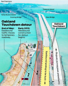 In March 2011, it was reported that traffic was going to be shifted on the Oakland end of the
bridge to accomodate construction. Specifically, in late May 2011,
Caltrans crews will move eastbound traffic coming off the bridge in
Oakland to the south as the start of a complex effort to open both
directions of the $6.3 billion new east span in 2013. The eastbound
traffic shift in May will make room for construction crews to widen the
westbound section of the bridge known as "the Incline" by building an
extension to the south. That will allow workers to shift westbound traffic
to the south (or left), which will permit crews to demolish the northern
edge of the incline, and clear the way for completion of the eastbound
landing, also called the Oakland Touchdown, of the new span. That detour
will take place in early 2012. The original plan called for the westbound
lanes of the bridge to open first, sometime in 2013, with the eastbound
direction following at least four to six months later because a section of
the westbound incline on the existing bridge stands in the path of the new
eastbound span. But progress on the single-tower suspension span and the
connection to Yerba Buena Island convinced Caltrans engineers they could
speed completion of the Oakland landing and open both directions
simultaneously.
In March 2011, it was reported that traffic was going to be shifted on the Oakland end of the
bridge to accomodate construction. Specifically, in late May 2011,
Caltrans crews will move eastbound traffic coming off the bridge in
Oakland to the south as the start of a complex effort to open both
directions of the $6.3 billion new east span in 2013. The eastbound
traffic shift in May will make room for construction crews to widen the
westbound section of the bridge known as "the Incline" by building an
extension to the south. That will allow workers to shift westbound traffic
to the south (or left), which will permit crews to demolish the northern
edge of the incline, and clear the way for completion of the eastbound
landing, also called the Oakland Touchdown, of the new span. That detour
will take place in early 2012. The original plan called for the westbound
lanes of the bridge to open first, sometime in 2013, with the eastbound
direction following at least four to six months later because a section of
the westbound incline on the existing bridge stands in the path of the new
eastbound span. But progress on the single-tower suspension span and the
connection to Yerba Buena Island convinced Caltrans engineers they could
speed completion of the Oakland landing and open both directions
simultaneously.
(Source: SF Chronicle, 2/18/11)
The Bay Bridge Troll
 Now that the construction of the $6.3 billion new east
span is nearing completion, plans are starting for the demolition of the
old Bay Bridge. Caltrans' goal is to start demolition as soon as traffic
gets moving on the new bridge. The work is expected to cost $239 million
and take about two years. Demolition crews will begin not at either end of
the span, but with the cantilever section, the long stretch in the center.
They're starting with that segment because it sits in the way of both the
bicycle path and a new eastbound on-ramp from Treasure Island. The span
will not be imploded; workers will dismantle the old bridge. It is up to
the contractor to determine whether they'll take it apart piece by piece
or remove large sections at a time and ship them by barge to dry land for
dismemberment. One thing guaranteed is that the old span will not be
reused in place for non-highway purposes, as it is seismically vulnerable.
Caltrans will choose to save some pieces - possibly the start of the
cantilever span or an entire section of the bridge - for display in a
museum or the Gateway Park planned on the Oakland end. What Caltrans
doesn't claim becomes the property of the contractors, who will most
likely recycle the steel. One piece of steel sure to survive is the
now-famous Bay Bridge troll, which lives out of drivers' sight on the
north side of the part of the east span that collapsed during the 1989
Loma Prieta earthquake. The troll, which an artist crafted from a chunk of
metal during the bridge repair work, has a barrel-like body and spindly
arms and legs. He's leaning forward slightly and holding what looks like a
rod. The creature is supposed to bring good luck to the bridge, protecting
it against future quakes. Caltrans has not yet decided whether to move the
troll into a museum or to relocate him to the new east span. But it would
clearly be bad luck - and bad PR - to get rid of the nameless guardian,
which has many fans as well as his own Facebook page.
Now that the construction of the $6.3 billion new east
span is nearing completion, plans are starting for the demolition of the
old Bay Bridge. Caltrans' goal is to start demolition as soon as traffic
gets moving on the new bridge. The work is expected to cost $239 million
and take about two years. Demolition crews will begin not at either end of
the span, but with the cantilever section, the long stretch in the center.
They're starting with that segment because it sits in the way of both the
bicycle path and a new eastbound on-ramp from Treasure Island. The span
will not be imploded; workers will dismantle the old bridge. It is up to
the contractor to determine whether they'll take it apart piece by piece
or remove large sections at a time and ship them by barge to dry land for
dismemberment. One thing guaranteed is that the old span will not be
reused in place for non-highway purposes, as it is seismically vulnerable.
Caltrans will choose to save some pieces - possibly the start of the
cantilever span or an entire section of the bridge - for display in a
museum or the Gateway Park planned on the Oakland end. What Caltrans
doesn't claim becomes the property of the contractors, who will most
likely recycle the steel. One piece of steel sure to survive is the
now-famous Bay Bridge troll, which lives out of drivers' sight on the
north side of the part of the east span that collapsed during the 1989
Loma Prieta earthquake. The troll, which an artist crafted from a chunk of
metal during the bridge repair work, has a barrel-like body and spindly
arms and legs. He's leaning forward slightly and holding what looks like a
rod. The creature is supposed to bring good luck to the bridge, protecting
it against future quakes. Caltrans has not yet decided whether to move the
troll into a museum or to relocate him to the new east span. But it would
clearly be bad luck - and bad PR - to get rid of the nameless guardian,
which has many fans as well as his own Facebook page.
(Source; SF Chronicle, 11/25/11)
In August 2013, it was reported that the plan was to retain the troll on the Old Bay Bridge because there will be workers tearing down the old bridge and they will need protection. Later, it will be removed and put in a safe place somewhere near the bridge. The Bay Bridge managers have also proposed that a similar troll be created for the new span for "a possible extra measure of safety."
 In September, it was reported that the Metropolitan
Transportation Commission -- which doubles as the Bay Area Toll Authority
-- confirmed that a new creature has come into the possession of "trusted
guardians who can be counted upon to make the decisions that are truly in
the best interests of the troll." It arrived at a construction site in an
unmarked pickup, he said, stands about 2 feet tall and is made of solid
steel. An MTC representated stated "It is a fact that there is a new Bay
Bridge troll It is a fact that the new Bay Bridge troll was revealed last
night to a small number of transportation officials and staff. It is a
fact that this occurred under cover of darkness given the troll’s
aversion to direct sunlight." The rumor is that the new troll has a
temporary place to stay inside one of the many hollows of the new span
while its "guardians" seek the perfect permanent location -- in shade, of
course, but possibly also a perch that might be viewed from the pedestrian
and bicycle path that made its debut Tuesday. As for the old troll,
Ironworker James "Fish" Sturgeon, carefully -- and quietly -- removed the
old troll from his perch on a shaded steel beam just after the old Bay
Bridge closed. Sturgeon told the creator of the old troll that after
cutting the bolts and grinding down the welds, he grabbed the beast to
pull it off and met resistance. "It was as if it was fighting back, not
wanting to go, knowing there was still a bridge to protect," he told the
artist. "I had to wrestle it off." Another odd thing, the troll's creator
notes: When it was removed its shadow remained on the girder. "The
protective and benevolent magical energy that the troll has been casting
on the Bay Area commuters and all the bridge workers has etched the
troll's image into the steel," according to Sturgeon. What will happen to
the old troll. The favored plan, according to a detailed report, is to
protect the former troll in a quiet setting open to the public at the
Oakland toll plaza.
In September, it was reported that the Metropolitan
Transportation Commission -- which doubles as the Bay Area Toll Authority
-- confirmed that a new creature has come into the possession of "trusted
guardians who can be counted upon to make the decisions that are truly in
the best interests of the troll." It arrived at a construction site in an
unmarked pickup, he said, stands about 2 feet tall and is made of solid
steel. An MTC representated stated "It is a fact that there is a new Bay
Bridge troll It is a fact that the new Bay Bridge troll was revealed last
night to a small number of transportation officials and staff. It is a
fact that this occurred under cover of darkness given the troll’s
aversion to direct sunlight." The rumor is that the new troll has a
temporary place to stay inside one of the many hollows of the new span
while its "guardians" seek the perfect permanent location -- in shade, of
course, but possibly also a perch that might be viewed from the pedestrian
and bicycle path that made its debut Tuesday. As for the old troll,
Ironworker James "Fish" Sturgeon, carefully -- and quietly -- removed the
old troll from his perch on a shaded steel beam just after the old Bay
Bridge closed. Sturgeon told the creator of the old troll that after
cutting the bolts and grinding down the welds, he grabbed the beast to
pull it off and met resistance. "It was as if it was fighting back, not
wanting to go, knowing there was still a bridge to protect," he told the
artist. "I had to wrestle it off." Another odd thing, the troll's creator
notes: When it was removed its shadow remained on the girder. "The
protective and benevolent magical energy that the troll has been casting
on the Bay Area commuters and all the bridge workers has etched the
troll's image into the steel," according to Sturgeon. What will happen to
the old troll. The favored plan, according to a detailed report, is to
protect the former troll in a quiet setting open to the public at the
Oakland toll plaza.
In June 2019, a tweet revealed the location of the old
Troll: It's in the CalTrans lobby! If you want to visit this dude, look in
the east hallway (111 Grand Ave).
(Source: East Bay Yesterday, 6/28/2019)
Western Span Bay Bridge Lighting Installation
In December 2011, it was reported that Leo Villareal, who has exhibited light sculptures at the National Gallery of Art and other major museums, would like to turn the western span of the Bay Bridge into the region's biggest light sculpture with 25,000 bulbs flickering from its cables in sequences inspired by the ebbs and flows of the bay environment. He has already has mapped out a framework for computer software to operate the network of LED lights. The project needs approval from Caltrans, as well as $7 million in private donations. Arts supporters kicked off a fundraising drive in late December, saying they hope to start the four-month-long light installation in spring 2011. The 25,000 white lights will shine, flicker and dim in sequences controlled by software Villareal is writing to reflect the moods and personality of the bay. Before work can begin, Caltrans must grant permits ensuring that the lights won't damage the bridge, block traffic or disrupt drivers with distractions. The 1-inch LED lights will be placed on the outside of bridge cables so they won't be visible to bridge drivers and distract them. Laborers secured by harnesses will attach the lights to bridge cables at night to minimize disruptions to the 280,000 vehicles a day that cross the bridge. A necklace of lights was installed across the Bay Bridge in the 1980s, but it is permanent, unlike the light sculpture that will be removed after two years.
The lights were turned on in March 2013. Each night between dusk and 2 a.m., the lights will appear to move along the north-side cables of the 1.8-mile span in patterns and sequences generated by artist Leo Villareal via programmed computers located in the central anchor of the bridge. It is a work of public art, funded without taxpayer dollars. As of March 2013, organizers have raised about $6 million to cover the costs, which include a little over $15 per night in electricity. The project was the brainchild of Ben Davis, a creative consultant, who pitched the idea as a gift to the community, and organized by Illuminate the Arts, a San Francisco nonprofit that promotes public art programs. The effort required a wide range of permits and cooperation from Caltrans, the Coast Guard and even the U.S. Fish and Wildlife Service. Villareal has a two-year permit to operate the art installation on the bridge.
On the eastern span, it was reported that Caltrans was going to show it off with $2 million worth of "aesthetic lights". Of the 7,800 LED lights installed along the bridge's suspension section, the first batch - 5,500 LEDs - is illuminating the span's 200 cables, giving the bridge its cathedral-like look. In November 2013, workers installed 800 lights at the tower's base at the waterline and another 1,500 at deck level. After some fine-tuning, Caltrans intends to have all the lights turned on by the end of the 2013. The light designer was Howard Brandston, who did the new lights for the Statue of Liberty. The custom-made fixtures for the span were produced by Musco Lighting, which also did fixtures for Yankee Stadium and the White House.
In December 2014, it was reported that the LED lights
had been saved. The bridge’s official overseers, the Bay Area Toll
Authority, gave its blessing to a proposal to reinstall the lights —
in time for the January 2016 Super Bowl — as a permanent fixture on
the four-tower suspension span. The “Bay Lights,” billed as
the world’s largest light sculpture, uses 25,000 LED lights to turn
the 1.8-mile span into a nightly light show displaying constantly changing
abstract images. It was intended as a temporary, two-year installation.
The authority’s oversight committee unanimously approved an
agreement under which the artist and nonprofit that installed the work
would take it down in March then reinstall it in a sturdier form by the
start of 2016 and turn it over to Caltrans. It was first announced as a
temporary two-year installation to be taken down in March 2015. Now, after
some cable maintenance and repainting, it’s to be replaced with a
sturdier set of lights that will begin glowing in time for Super Bowl 50,
scheduled for February 2016 at Levi’s Stadium in Santa Clara. The
agency would the Lights, and the Bay Area Toll Authority would pay the
$250,000 bill for maintenance and electricity — from toll revenues.
The agreement required the nonprofit Illuminate the Arts foundation to
raise $4 million; in mid-December, ITA announced that it had raised the
needed funds to reinstall the “Bay Lights” as a permanent
fixture on the western end of the bridge. The fundraising success was made
possible by a $2 million matching gift from philanthropist Tad Taube of
Woodside.
(Source: SF Chronicle, 12/10/2014; 12/17/2014)
In July 2015, it was reported that Bay Area Toll
Authority approved a 10-year, $2.1 million contract for Philips Lighting
North America Corporation to maintain the Bay Lights installation once it
returns as a permanent fixture next year. The 25,000 lights were first
installed in 2013 as part of the Bay Bridge 75th anniversary
celebration. They turn on and off in patterns as programmed by artist Leo
Villareal, invoking drifting clouds, sea creatures or just elaborate
patterns. The lights quickly became a fixture of the San Francisco
waterfront, and late in 2014, Caltrans and the Toll Authority agreed to
take over the installation and make it permanent.
(Source: KCBS, 7/8/2015)
In October 2015, it was reported that the popular
1.8-mile-long LED light sculpture on the Bay Bridge known as The Bay
Lights is shining again. The lights were removed in March to allow
Caltrans crews to perform maintenance on the bridge cables of the Bay
Bridge's western span. They were reinstalled and will continue shining at
least through now Super Bowl 50, which will be played at Levi's Stadium in
Santa Clara on Feb. 7.
(Source: Pleasanton Weekly, 10/8/2015)
In December 2015, it was reported that artist Leo
Villareal is currently testing the Bay Lights on the Bay Bridge. Villareal
works from Pier 14, where he has custom software to control the lights.
After testing in mid-December, the lights will go dim until they are
turned on again permanently on Jan. 30 as one of the events leading up to
Super Bowl 50.
(Source: SFGate, 12/16/2015)
In January 2023, it was reported that the lights on the
Bay Bridge might be going out. The nonprofit, Illuminate, which launches public works of art, teamed up with New York-based light
artist Leo Villareal to create “Bay Lights” in 2013. The
1.8-mile project uses 25,000 LED lights across 300 cables on the western
side of the bridge. Though the display was initially intended as a
temporary installment to commemorate the bridge’s 75th
anniversary, the Bay Area Toll Authority agreed in 2014 to make it a
permanent installation and fund the maintenance of the lights. The agency
agreed to bear the maintenance cost of $250,000 a year, while Illuminate
at the time announced that it had raised $2 million from philanthropist
Tad Taube to help make the project permanent. The entire cost for the
project, expected to last 10 to 12 years, was estimated to be $12 million.
The actual cost was about $6 million, although the lifespan of the lights
ended up being three years less than expected. The harsh environment of
the bay, including strong winds, fog, salty air, lightning strikes and
vehicle exhaust, has taken a toll, leaving dark patches among the lights
where bulbs need replacement. The expansion of the cables and constant
vibration also make it an environment where electronics are
“unwelcome,” which means that the project will have to come
down by March. Illuminate is looking to raise $11 million by March 5, not
to keep the lights — but to replace them with others that can endure
the environment better. They also are hoping to expand the display to both
sides of the bridge. The entire project would consist of 50,000 lights and
would have an expected lifespan of about 10 years. The lights would be
visible to drivers, to people flying over the bay, and to those viewing
the bridge in San Francisco as well as from across the water in Oakland.
They have already secured an Iowa-based company to make new lights
specially designed for the bay’s environment. As of March 1, 2023,
$6 million had been raised from corporate donors (out of $10 million), and
$360K had been raised out of the $1 million that was to be crowdfunded.
(Source: Los Angeles Times, 1/10/2023; Illuminate, 4/22/2023)
In December 2023, it was reported that the Bay Bridge
light show that went dark in March could return by the fall, organizers
said, as they get closer to raising the money needed to restore the iconic
light art installation. Illuminate, the nonprofit that installed and
operated The Bay Lights for 10 years, has raised almost 90% of its $11
million fundraising goal. The money is being raised through a $1 million
crowdsourced fundraiser and by soliciting $10 million in private
donations. Some of the project's biggest donors include WordPress founder
Matt Mullenweg, WhatsApp founder Jan Koum and Parnassus Investments
founder Jerry Dodson, who have each pledged $1 million. Now, all but
roughly $1.5 million has been raised to restore the project, with the
crowdsourced fundraiser over halfway toward its $1 million goal. The
expectation is that the lights would return to the bridge within eight to
10 months if the rest of the funding comes in.
(Source: San Francisco Standard, 12/28/2023)
Demolition of the Old Eastern Span
In January 2012, it was reported that demolition will
take longer than expected. According to new projections, it will cost $244
million and take between five and seven years to remove the 75-year-old
span of the Bay Bridge that connects Yerba Buena Island to Oakland. The
original two-year timeline for the demolition was a very preliminary
projection. The complexity of the plan — notably dismantling the
cantilever segment — calls for a time-consuming project.
Additionally, because the structure of the existing eastern span contains
several hazardous materials, notably 75 years of lead paint, the
demolished segments cannot just rest on the Bay floor. Updated estimates
indicate that demolition will need three phases, with the first part
starting in late 2013, when the cantilever superstructure of the eastern
span is removed. A contract for that removal will go out to bid in Spring
2012, and is expected to be approved by summer, so demolition of the
cantilever segment can begin “within days” of the new eastern
span’s opening date in late 2013. Once the cantilever is removed,
crews will take down the steel trusses that compose the bulk of the
existing eastern span. Last, the foundation pilings of the bridge will be
uprooted, completing the demolition project.
(Source: San Francisco Examiner, 1/31/2012)
Once traffic was moved to the new bridge over Labor Day weekend in 2013, the project to remove the Old Bay Bridge begins. Environmental restrictions bar dynamiting the old span, so it will have to be dismantled piece by piece - west to east and from the top to the bottom - to avoid a collapse. The first section to go will be the dreaded temporary S-curve detour. That permits construction of the bike connection to Treasure Island. Next comes dismantling the big cantilever truss section between the span's main towers. Then the road decks will go, and finally the foundations. The main visible portion will be gone in 9 months; it will be an additional two years before the old span is down to the mud line. Some of the old bridge pieces will be kept for historic purposes. But much of the concrete and steel will be recycled or sold for scrap - possibly to China - though the toxic lead paint that has coated the span for years could limit some of its reuse.
Finally, in November 2013, demolition crews started work on taking down the old Bay Bridge. In mid-November, demolition crews, who had been preparing the 77-year-old bridge for its departure since its replacement,began ripping out the upper road deck of the cantilever section. Destruction started on the date that was the anniversary of the bridge's opening. Giant red jackhammers relentlessly pounded away at the pavement, occasionally causing the old steel span to shudder and shake. Trucks hauled away the debris to a remote site, where it will be beaten into smaller chunks, the steel rebar removed so the concrete can be recycled.
In April 2014, it was reported that the old bridge has been cut in half by slicing through metal sections of the cantilever section east of Yerba Buena Island. Contractors are dismantling the 77-year-old span in reverse order of how it was constructed in the 1930s. Contractors first will take apart the cantilever section and demolish the S-curve near Yerba Buena Island before moving east to take apart two truss spans. Crews will then work downward to remove the piers and foundation. When the demolition is complete, in three to five years, more than 58,000 tons of steel and 245,000 tons of concrete will have been removed.
In November 2014, it was reported that the new Bay
Bridge eastern span will likely end up at least $35 million in the red,
and officials are shifting money from other completed Caltrans bridge
projects to make up the difference. Bridge officials were hopeful the span
would cost less than the budgeted $6.4 billion. But there’s still as
much as $110 million worth of unbudgeted work to be done on the span.
Further, tearing down the old eastern span could end up costing $100
million more than estimated. It was also reported that Bay Area
transportation officials are contemplating a plan to leave parts of the
old eastern span of the Bay Bridge in place, a proposal that could
preserve history and bring down the price of demolition by millions of
dollars. Specifically, the MTC is considering leaving several of the old
piers, built in the 1930's, near the Oakland shoreline. These piers could
be repurposed into a walkway or left as historical pieces as part of the
proposed Gateway Park. The issue is that the current demolition agreement
requires the MTC remove all concrete, metal, every scrap of material; this
includes going below the mud line, which is very expensive. If the Coast
Guard, Bay Conservation and Development Commission and others agencies
sign off on leaving some of the piers it could save millions.
(Sources: KCBS, 10/30/2014, KTVUNovember
2014)
Truss-Span Removal
In February 2016, it was reported that work had
begun on the second phase of the demolition of the bridge, with removal of
the first 504-foot truss span. The process takes 2 14-hour days. On the
first day, crews will focus on severing the truss from its towers and its
slow decent toward the bay below. Crews will then concentrate on setting
the truss down on barges and transporting it to the Port of Oakland for
disassembly. Phase I was completed the end of 2015 when cantilever section
and S-curve to Yerba Buena Island was demolished. Phase II continues with
removal of the first five 504s and then removal of fourteen 288-foot truss
span sections that extend to the Oakland shore. Phase III will focus on
the demolition of the remaining marine foundations.
(Source: KRON, 2/4/2016)
By July 2016, it was being reported that crews were
removing the fourth of five 504-foot sections of the old eastern span of
the Bay Bridge.
(Source: KRON, 7/6/2016)
In August 2016, it was being reported that the
largest remaining piece of the original east span of the Bay Bridge was
being removed. Cables will lift the 3.2 million pound horizontal truss
from its 60-year-old supports, swing it to the side and pivot it out to be
lowered onto a pair of barges waiting below. The process should take 12
hours or so. The two barges then take a short voyage to the Port of
Oakland, where the trussed section will be transferred to land and
dismantled, with the individual beams winding up in recycling facilities
across the Bay Area.
(Source: SF Gate, 8/3/2016)
Eastern Span Pillar Removal
In February 2015, it was reported that Caltrans was
exploring using explosives to remove a large concrete pillar from the old
eastern span. They would be placed around the base of the pillar. Backers
of the plan say the explosion would be a faster, more economical
alternative to piecemeal demolition. Under this plan, the remaining
roadway will be removed and the implosion would get rid of the big pier.
Debris will collapse into a hole made by other charges in the ground. The
traditional approach is to put a big metal tube around underwater piers,
drain out the water, and lower work crews with big power tools knock the
thing down. If approved, the explosions would take place in November 2015.
Caltrans had originally intended to use cofferdams that would clear water
from the area around Pier E so crews could gradually demolish it, but such
work could take many months. The planned demolition procedure would
involve setting up an "air curtain" of pipes blowing compressed air
through the water around the pier. More than 600 small explosives would be
set in the concrete and detonated simultaneously, collapsing the rubble
within the air curtain. The biggest risk to surrounding wildlife --
including seals, sea lions and porpoises -- would be the sound of the
explosion, which could injure or even kill the marine mammals. November
was chosen to minimize the number of those animals in the water. Caltrans
plans to monitor both visually and acoustically to make sure there are no
animals in range, and would postpone the detonation if any were spotted.
Baykeeper is working with Caltrans to come up with ways to mitigate the
environmental impact as best as they can. There may be some trade off for
water quality impact versus wildlife impact, and they will be monitoring
closely how the process goes as Caltrans may use a similar method in
demolishing a dozen remaining support piers. This pier, however, is the
largest -- the equivalent of bringing down a 5-story building -- and will
be the trickiest to bring down.
(Source: KCBS 2/16/2015, InsideBay
Area, 8/19/2015)
In September 2015, it was reported that the U.S.
Army Corps of Engineers has given Caltrans final permission to carry out
the $160 million implosion of the largest concrete pier of the old Bay
Bridge eastern span. The project had already gotten the go-ahead from the
state boards of water quality, fish and wildlife as well as federal
agencies, including the National Oceanic and Atmospheric Administration
and the National Marine Fisheries Service, the Fish and Wildlife Service
and the U.S. Coast Guard. The San Francisco Bay Conservation and
Development Commission also recently approved the plan.
(Source: SF Chronicle, 10/2/2015)
In November 2015, the implosion took place. Over six
seconds, sprays of water shot into the air as workers set off 600 charges
that had been placed in pre-drilled holes in Pier E-3, a hollow,
reinforced concrete structure that stretched from the waterline to 175
feet beneath the bay floor. Planks were placed over E-3 to prevent debris
from flying onto the bridge and Caltrans briefly stopped traffic during
the demolition. Caltrans said most of the pier pieces either fell into or
will be placed in the pier’s hollow casing below the bay floor. The
agency decided to demolish the pier with explosives rather than
mechanically remove it because the latter method would have taken years
and required construction of a wall of piles to create dry space for
workers.
(Source: LA Times, 11/14/2015)
In March 2016, it was reported that in the wake of
the successful November 2015 implosion, Caltrans was seeking to demolish
15 remaining piers the same way at a cost of $130 million in what is
expected to be the final steps of removing the old bridge. Specifically,
Caltrans asked the Toll Bridge Oversight Committee, the three-member
governing body for the Bay Bridge retrofit project, to approve a contract
to a joint venture between construction and engineering firms Kiewit and
Manson. The implosion of Pier E3 in November demolished the pier in a
matter of six seconds, collapsing the pulverized concrete into the pier's
own buried cavities and burying it at the bottom of the Bay. Caltrans
officials said the method was not only more cost effective than
mechanically demolishing the pier, but more environmentally friendly as
well. Surrounding the pier with a dam, pumping the water out and
dismantling the pier with construction equipment would take months and
disrupt area wildlife in the process. If the contract is approved and
Caltrans is granted the necessary permits from federal and state agencies,
the next two piers would be removed this fall, followed by six more in the
fall of 2017 and seven more in the fall of 2018.
(Source: East Bay Times, 3/29/2016)
In August 2016, it was reported that Caltrans has
been granted permission to remove two piers of the old eastern span of the
Bay Bridge using the same implosion technique that safely demolished the
span’s largest pier in a matter of seconds last November. The San
Francisco Bay Conservation and Development Commission signed off on the
implosion technique for Piers E4 and E5, and the implosions could take
place as early as October 2016. The BCDC also granted approval for
Caltrans to remove 13 additional remaining piers over the next two years,
some by implosion and some by mechanical means.
(Source: SFBay.ca, 8/19/2016)
In March 2017, it was reported that The last chunk
of the old eastern half of the Bay Bridge, which over the years carried 3
billion motorists on their starry-eyed odysseys to San Francisco, was
hauled off to the junkyard. There it will fetch 10 cents a pound. The job
of doing away with the last remaining section of the bridge — a
288-foot-long truss section at the eastern end — was the stuff of
high drama. Dozens of demolition workers, two rusty barges, three tugboats
and a tall red crane worked together on a sparkling spring morning in an
exquisitely choreographed dance of death. The plan called for the 850-ton
chunk, after being cut free of its concrete pilings, to ride off to its
fate on two barges. The barges would be lifted into position beneath the
truss by the rising tide, which lifts all boats, barges included. It was
something like jacking up a car for a tire change, with nature playing the
role of the jack. Workers in orange vests were everywhere, and their
Caltrans supervisors, who wore neckties under their orange vests, were
supervising. There was nothing to do but wait, which everyone did for
about five hours, while the moon and Earth got themselves lined up into
their high tide arrangement. And then, shortly after 11 a.m., the water
level crept high enough to lift the barges into contact with the truss and
free it from its concrete pier. Shoved by three tugs and pulled by a
winch, the entire hodgepodge inched into the open bay and began its
half-mile journey to Pier 7, where the dismantlers with the blowtorches
were waiting to administer their unkindest cuts of all.
(Source: SF Gate, 3/28/2017)
In August 2017, it was reported that thirteen little
concrete islands that once helped hold up the old Bay Bridge east span
will be blasted into history in a series of implosions over six weekend
days beginning in September 2017 and concluding in November 2017. Five
other foundations are expected to be spared. Tentative plans call for a
large foundational pier near Treasure Island to be saved for conversion
into public spaces. Four piers on the east end in Oakland would be saved
for the same purpose. Caltrans also wants to spare as much bay wildlife as
possible and has been working with natural resources agencies to come up
with a suitable plan. The demolition work, which had been expected to
extend through fall of 2018, will now be finished by the end of 2017 under
the new plan that calls for imploding piers on certain weekends.
(Source: SF Gate, 8/21/2017)
In January 2018, it was reported that the public
will soon get two new places to view San Francisco Bay when observation
decks are built off Yerba Buena Island and Oakland on piers from the old
Bay Bridge eastern span, according to a memo by the Toll Bridge Program
Oversight Committee. The two projects involve building observation decks
on piers that were part of the old eastern bridge span instead of
demolishing the remaining piers. The oversight committee in December
approved building a deck on Pier E2 off Yerba Buena Island. The deck in
Oakland would be built on Piers E23 and E21, according to the latest
recommendation. Piers E19 and E20 would be removed. Under the current
project schedule, the construction contracts could be approved on or near
March 1, major marine work would start on or near June 1 and the decks
would be completed by the end of December. The $52 million project will
cost slightly more than demolishing the piers. On Yerba Buena Island, the
pier sits below the landing of the new bicycle and pedestrian path that
extends from Oakland in the East Bay, and there are plans to add a cafe in
the WWII-era building adjacent to the pier. On the Oakland side, the
committee decided to keep three of the five remaining piers but demolish
the two farthest out. It was too expensive to build the boardwalk out to
the fifth pier, according to a staff report, and provide ongoing
maintenance. The East Bay parks district has agreed to take over
maintenance for the new boardwalk, with ongoing financial support from
toll funds. The district is also designing a new “Gateway
Park” that will extend from a historic building — a former
rail car repair shop — to the new boardwalk. The district in
December signed a 10-year-lease for the 1930s-era building. The structure
will now serve as a visitors center and venue for conferences or other
gatherings. In between the building and planned boardwalk are 21 acres of
land that will be transformed into picnic, open space and seating areas.
There are also plans for a cafe or concession stand for park visitors,
along with bicycle and pedestrian trails. The district will release an
environmental impact review for Gateway Park in early 2018. The district
is still waiting on the U.S. Army to finish cleaning up parts of
contaminated soil that will make up roughly half the park, he said, so
it’s unclear when it will be fully completed.
(Source: San Mateo Daily Journal, 1/23/2018; EastBay
Times, 1/28/2018)
In October 2020, it was reported that Judge John
Sutter Regional Shoreline has opened to the public, showcasing views of
the eastern span of the Bay Bridge, and the San Francisco skyline. A
600-foot-long observation pier has been built atop six piles from the
original Bay Bridge. Benches, tables, and light stands along the pier use
steel from the old bridge. Walking paths, interpretive panels, bathroom
facilities, and a new parking lot were constructed for the bay side park.
There is also a connection to the Bay Bridge Bicycle-Pedestrian trail that
goes to Treasure Island. The Bridge Yard, a 1930’s era train
maintenance building has been renovated to hold concerts, and community
events at the park which is operated by the East Bay Regional Park
District.
(Source: East Bay Times, 10/21/2020)
Disposition of the old Bay Bridge Steel
In September 2014, it was noted that at least 300
tons of the old Bay Bridge will live on in California public art projects
that could include anything from light poles or street benches to large
sculptures. The Oakland Museum of California will administer the program,
including choosing the projects that seem most appropriate. Up to $2.2
million will be spent to salvage steel from the old span, cleanse it of
toxic lead paint, stockpile it and distribute it to artists from all over
the state who make proposals.
(Source: SF Chronicle, 9/30/2014)
In June 2015, it was reported that the Oakland
Museum of California had announced it will work with transportation
officials to connect artists, architects, civic planners and other
designers throughout the state with sections of the still-being-demolished
1936 span. The idea is to repurpose the pieces in public installations
that somehow commemorate the history of the bridge and its role in shaping
the region as we know it today. The first of three rounds in the
application process runs through Oct. 1, 2015. Entries may be submitted at
www.museumca.org/bay-bridge-steel. The $2.2-million distribution program, titled the Bay Bridge Steel
Program, will involve removing toxic led paint from the steel, and
relocating and storing the hefty pieces. Administered by the museum in
conjunction with the Toll Bridge Program Oversight Committee -- made up of
representatives from Caltrans, the Bay Area Toll Authority and the
Metropolitan Transportation Commission -- the program was indeed developed
in response to requests from local artists. Early last year, Karen
Cusolito, founder of American Steel Studios in West Oakland, launched BayBridgeSteel.org and started an online petition to generate support for preserving at least some of the
vintage steel, "keeping it in the Bay Area for public art and civic
installations for everybody to enjoy," the site says. Pieces of cleaned
and salvaged steel will be distributed in mid-2016 at no charge to
selected applicants. The program does not provide funding for the projects
and is not involved in securing permission for placement of public
artworks.
(Source: Inside Bay Area, 6/2/2015)
In December 2015, it was reported that salvaged
steel from the old eastern span of the Bay Bridge has been awarded to five
projects for public display, with more awards on the way. The chosen
projects include a public sculpture near the Petaluma River, a gate for an
arts center in Joshua Tree, two public installations near the bridge and
an observation platform for a park in San Francisco’s Mission Bay
neighborhood. The steel was salvaged from the ongoing dismantling of the
old Bay Bridge, which started last summer. The Toll Bridge Program
Oversight Committee, the governing body for the construction of the new
eastern span, directed the museum to find artists to award the salvaged
steel. The five projects chosen are the first of three rounds of awards of
bridge steel. Applicants for future rounds must submit proposals by May 2
or Dec. 1 of next year. Among the recipients of this round are San
Francisco landscape architecture firm SURFACEDESIGN, which is planning an
overlook and viewing platform at a Mission Bay park. The platform will be
constructed of bridge trusses and other steel and a series of interactive
exhibits in the park will teach visitors about the history of the bridge
and its construction. Another proposal by Oakland-based Hyphae Design Lab
would create several installations in the redevelopment of the old Oakland
Army Base. Development of that space as a new logistics center for the
Port of Oakland is finally underway after the land was turned over to the
city and port a decade ago. The proposed installations by Hyphae would
incorporate the original 504-foot truss spans, fashioning them into a
bridge tower that would frame the touchdown of the bicycle and pedestrian
route on the new eastern span and an observation deck at Burma Road and
Maritime Street with views of the port and bridge. Another proposed
installation would be built near the bridge, possibly on Treasure Island.
Bay Area artist Tom Loughlin designed a sound and light sculpture from an
old Bay Bridge warning light that would incorporate top beams for seating
around it. Loughlin hopes the piece will evoke thoughts of the natural
landscape and the tools humans have built to help them traverse it,
according to museum officials. Sculptor Paul Lorentz of Petaluma will
build a sculpture from bridge trusses near the Petaluma River, a design
that will feature two separate cantilevered structures with a space
between them that will call to mind the power of the bridge just before
its completion. The last award announced was to the Harrison House, an
arts center just outside of Joshua Tree National Park, where the
bridge’s top horizontal braces will be fashioned into an entry gate.
No timeline was given for completion of the sculpture and structures
approved. Applicants interested in future awards can find application
materials at museumca.org/bay-bridge-steel.
(Source: KCBS, 12/15/2015)
In August 2016, it was reported that artists hoping
to claim some of that salvaged steel took a tour of some of the 450 tons
of metal awaiting its new home. Pritchett of the Oakland Museum of
California is leading a new program administered by the museum to help the
state distribute the steel to artists across California. The program has
already allocated steel for six projects — with a second round of
applications due in December. The newly removed steel bore marks where the
dismantlers' cutting torches sliced through, creating a patina in the
layers of paint applied over more than a quarter-century. Artist Graham
Prentice is part of a group already selected to receive a portion of the
salvaged steel. Prentice said his group plans to build a public structure
at the Port of Oakland to welcome truckers, the public and bicyclists. The
steel will go to a number of art projects ranging from massive
installations to smaller pieces.
(Source: NBC Bay Area, 8/18/2016)
In January 2017, it was reported that The Oakland
Museum of California had announced the final five winners of sections of
steel, rivets and an old Bay Bridge warning light, all to be used in
public projects around California. The Bay Area Toll Authority had put the
museum in charge of sifting through applications from dozens of artists
who wanted to work with material from the iconic cantilever section of the
bridge. OMCA had picked some of the winners in earlier announcements.
Fifteen artists and design teams will get a chance to build, among other
things, playful structures on Treasure Island, artwork just north of the
Ferry Building, a sundial at Laney College, a sculpture near the Petaluma
River and the platform for a miniature railroad in Truckee. Among the
newly chosen projects, one that seems timed to the inauguration of
President Trump; “Building Bridges, Not Walls,” by the Living
New Deal Project, highlighting the contributions of immigrant workers in
building the bridge.
(Source: KQED, 1/17/2017)
In June 2017, it was reported that artists
representing 14 art projects turned out at a Caltrans yard in Oakland
— which sits in view of where the old span was replaced by a sleek
new one — to claim their allotment of the bridge’s salvaged
steel. The program required artists receiving steel to build public
projects — and provide their own trucks to haul it away. One artist,
for example, plans to build a metal wind chime for San Francisco’s
Pier 3 that will pay tribute to the statue of Pacifica that stood at the
Treasure Island World’s Fair. The beams getting distributed ranged
in weight from a thousand pounds to twelve tons. Artist Tom Loughlin went
for the top of the scale in picking out four twelve-ton pieces for the
sound sculpture he plans to build for Treasure Island — which has
allotted $50 million for public art. Each beam required its own big rig to
haul it away. In addition to the large steel beams, the salvage included
recognizable pieces such as the lights that sat atop the bridge’s
towers. The various pieces would go to projects across the Bay Area and as
far away as Truckee and Joshua Tree.
(Source: NBC Bay Area, 6/20/2017)
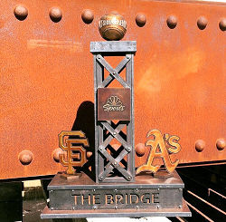 One of the uses of the old Bay Bridge steel was to make a annual A/Giants Baseball Rivalry
trophy. The twitter discussion played out over a few months, and resulted in a 26-lb trophy.
One of the uses of the old Bay Bridge steel was to make a annual A/Giants Baseball Rivalry
trophy. The twitter discussion played out over a few months, and resulted in a 26-lb trophy.
The Double-Crested Cormorants
In May 2017, it was reported that it took millions of
dollars, the use of decoys, bird-call recordings and dried-out holiday
wreaths — and a limitless amount of patience. But the Bay
Bridge’s recalcitrant double-crested cormorants have finally moved
to their new home on the sides of the bridge’s new east span. The
demolition of the cormorants’ former home, the old bridge’s
gray east span, may have been the determining factor in a successful
relocation. Reality seems to have set in early last month, days after the
last trestle of the old east span was hauled away. That’s when the
black birds with orange and white faces and a 4-foot wingspan began
settling in to the “cormorant condos” built for them on
viaducts of the east span’s concrete skyway section in Oakland. More
than $10 million from the new Bay Bridge budget was spent on the project.
At first, just a couple of cormorants landed on $709,000 metal platforms
contractors had attached to the sloping sides of the east span. But within
weeks, at least 30 birds had followed the early settlers. Despite
Caltrans’ best efforts to get the cormorants to relocate, the birds
were stubborn as toddlers. Even after traffic moved to the new bridge in
2013, the birds stayed put. Caltrans and the MTC tried to lure them with
decoys and recordings of bird calls. They even brought in mirrors to trick
them into thinking there were others cormorants there when they saw their
reflections. And they plopped down old holiday wreaths to make it look
like other birds had previously nested on the platforms. But nothing
worked — until the last truss section of the old east span was cut
free on March 28, placed on a barge and floated into history. On Friday,
hundreds of the birds were spread out along the rows of 4-foot-by-4-foot
steel grate platforms that are bolted to the inside edges of the bridge
between piers 6 and 8 near the eastern end of the span. The birds are
believed to have settled in the Bay Area in 1984 from such places as
Alaska, Mexico and Nova Scotia. Besides the Bay Bridge, colonies exist on
the Richmond-San Rafael Bridge and electrical towers in the South Bay.
Rauzon said there may be as many as 700 birds residing on the new east
span. The move cost millions, but exactly how much depends on what costs
are counted. In addition to the cost of building the platforms, Caltrans
and MTC spent $1 million to coax the cormorants into their new condos and
another $1.6 million to place netting on the old span to drive the birds
away from their old home. Caltrans also spent $12.8 million to get bridge
demolition work done without interfering with the birds’
April-to-August breeding season.
(Source: SF Chronicle, 5/19/2017)
All That Remains Are The Lawsuits
In June 2018, it was reported that, in the end, all
that remains are the lawsuits. At a bridge oversight panel meeting in late
June, Caltrans officials outlined an emerging dispute over the $11 million
tab the U.S. Navy claims Caltrans should pay to clean up what had been its
landfill site on Yerba Buena Island. That site was turned over to Caltrans
to allow for bridge construction back in 2001 – without the Navy
doing the promised cleanup. The Navy now asserts those cleanup costs
should be footed by Caltrans because the so-called Site 11 has since been
contaminated by bridge paint, waste and debris. That claim left bridge
officials fuming. “We’re not going to pay a dime to clean up
the Navy’s mess,” said Steve Heminger, Executive Director of
the Metropolitan Transportation Commission, after being briefed on the
issue. “I just think that’s outrageous.” Heminger, who
chairs the three member bridge project oversight panel, said the demand
was especially galling given the Navy’s role in fighting the planned
alignment of the new span in the early days, which he says contributed to
delays in construction. Meanwhile, the oversight panel voted Thursday to
settle a long-running dispute with the main contractor on the project,
American Bridge/Fluor. Under the deal, the bridge builder will get $25
million -- half has much as it had sought in its claims against Caltrans.
But Caltrans will not pursue $8 million it had argued the company owed to
fix the high strength rods that failed on the span back in 2013. Caltrans
is now promising to pay its $8 million share of the of the $24 million
bill for the retrofit of the broken rods and has pledged to press bridge
consultants TY Lin International to pay their one-third share of the fix.
That sum could help bring in the seismic retrofit program without a
deficit, or even with a surplus, thanks to $24 million in savings from
other bridge projects.
(Source: NBC Bay Area, June 22, 2018)
Bay Bridge Forward (I-580: Route 980 (~ 04-ALA-580 45.168) to I-80 (~ 04-ALA-580 46.473R); I-80: Alameda Cty border on the bridge (04-ALA-080 0.0) to Route 13 (04-ALA-080 4.678)
 In 2016, the Bay Bridge Forward initiative started. Bay Bridge
Forward is a set of investments and strategies to improve efficiency,
reduce delays and move more people and buses across the most-traveled
bridge in the Bay Area. Operational improvements planned as part of this
project include:
In 2016, the Bay Bridge Forward initiative started. Bay Bridge
Forward is a set of investments and strategies to improve efficiency,
reduce delays and move more people and buses across the most-traveled
bridge in the Bay Area. Operational improvements planned as part of this
project include:
(Source: MTC Bay Bridge Forward page, 11/2022)
A briefing in July 2021 noted that that the goal is to
deliver the I‐80 Powell, I‐80 Bus Lane, and I‐580 WB HOV
Lane Projects by 2023. There are some statutory exemptions that will
support this (SB 288), and there is Design Engineering Evaluation Report
(DEER) Eligibility for Caltrans Approval. The MTC/ACTC will continue to
seek funding to advance other Bay Bridge Forward projects.
(Source: Alameda CTC Bay Bridge Forward Brifing, 7/2021)
In June 2021, the CTC approved including "Bay Bridge
Forward: I-580 WB HOV Lane Extension" in the list of projects for the
Coronavirus Response and Relief Supplemental Appropriations Act of 2021
(CRRSAA). The CRRSAA Program guidelines require regions submit a project
list for allocation by the Commission prior to the obligation of funds.
Under CRRSAA, the funds may be used for a broad range of surface
transportation purposes listed in Section 113(b) of Title 23 of the U.S.
Code and are meant to “prevent, prepare for, and respond to
coronavirus.” Specifically, CRRSAA allows states to cover revenue
losses, which is important given that California’s State-generated
transportation revenues have declined by about $1.5 billion due to the
pandemic. Additionally, CRRSAA allows the funds to be used for preventive
and routine maintenance; operations; personnel; salaries; contracts; debt
service payments; and availability payments; as well as transfers to
public tolling agencies. At the March 2021 Commission meeting, the CTC
approved the CRRSAA funding distribution and regional apportionments. The
CRRSAA allocation for this project was $7,000,000.
(Source: June 2021 CTC Minutes, Agenda Item 2.5k)
In May 2007, flames from an exploding gasoline tanker travelling S on the transition road from I-80 to SB I-880 (~ ALA 3.086 to ALA 3.348) melted the steel underbelly of the I-580 bridge that carried EB traffic from the Bay Bridge to I-580, I-980, and Route 24. The single-vehicle crash occurred on the lower roadway when the tanker, loaded with 8,600 gallons of unleaded gasoline and heading from a refinery in Benicia to a gas station on Hegenberger Road in Oakland, hit a guardrail. Amazingly, damage to the I-80 transition roadbed was minor, and Caltrans was able to reopen the span within two weeks.
Note that there are some portions here that have interesting trailblazers: West I-80 and East I-580 (or East I-80 and West I-580). You can find a picture of this here.
I-80/Ashby Avenue (Route 13) Interchange Improvements (~ ALA 4.538)
 In June 2021, the CTC approved amending the STIP to use
the funding available through the 2021 Mid-Cycle STIP and share
distribution of the federal Coronavirus Response and Relief Supplemental
Appropriations Act of 2021 funds (COVID Relief Funds) to add a new project
to the STIP: Route 80 Ashby Interchange Improvements (PPNO 0069V); program
$50K to the PS&E phase in FY 2022-23.
In June 2021, the CTC approved amending the STIP to use
the funding available through the 2021 Mid-Cycle STIP and share
distribution of the federal Coronavirus Response and Relief Supplemental
Appropriations Act of 2021 funds (COVID Relief Funds) to add a new project
to the STIP: Route 80 Ashby Interchange Improvements (PPNO 0069V); program
$50K to the PS&E phase in FY 2022-23.
(Source: June 2021 CTC Agenda, Agenda Item
2.1a.(19); Image source: Project Fact Sheet from Alameda CTC)
This project proposes to reconstruct the I-80/ Ashby
Avenue interchange to improve accessibility, safety, traffic flow, and
bicycle and pedestrian facilities. These improvements are intended to
provide traffic congestion relief and enhanced mobility at this critical
access point and important intersection of regional transportation routes.
The project will also provide multimodal transport options, while
improving community connectedness, including connectivity to the existing
Bay Trail. This project was approved by Alameda County voters in 2014
under Measure BB and represents a direct investment in regional
infrastructure and economic development. It will provide a direct
connection between westbound I-8) and Emeryville by way of Shellmound
Street. Improvements will include:
(Source: Ashby Avenue Interchange Improvement Page, September 2021)
The estimated costs by phase ($ x 1,000) are:
PE/Environmental $4,500; Final Design (PS&E) $10,500;
Right-of-Way/Utility $4,400; Construction $137,600; Total Expenditures
$157,000.
(Source: Ashby Avenue Interchange Improvement Page, September 2021)
In January 2022, a few more details were reported. The
new bridges will provide vertical clearance along I-80 for freight
vehicles. The new interchange structure will supply better connections to
Shellmound Street, Frontage Road, and Point Emery. There will be a new
shared bicycle and pedestrian pathway to afford direct access to the San
Francisco Bay Trail. The project’s eastern end connects with a
concurrent development that should include raised, protected bike lanes on
part of Shellmound. However, that does not address the increased traffic
coming off the freeway where the ramps intersect.
(Source: Streetsblog SF, 1/13/2022)
MacArthur Maze Vertical Clearance Project – 80 (PM 2.8)/580 (ALA PM 46.5R & 46.5L)/880 (ALA PM 34.5L)
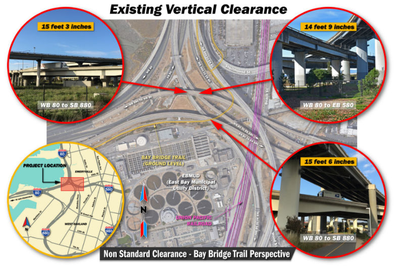 In March 2019, Caltrans started holding public hearings on the MacArthur Maze Vertical Clearance Project, whichwould to increase the vertical clearances at three locations within
the MacArthur Maze Interchange (MacArthur Maze or Maze) in the City of
Oakland, Alameda County. Two of the locations are along the connector from
westbound (WB) I-80 to southbound (SB) I-880, as it crosses below the WB
and eastbound (EB) I-580 overcrossings. The third location is along the
connector from WB I-80 to EB I-580 as it crosses below the connector from
WB I-580 to WB I-80. The existing vertical clearance at these three
locations does not meet the current Caltrans standard of 16 feet 6 inches
and impedes the safe and efficient movement of oversized vehicles and
loads through the Maze. The project is proposed to increase the vertical
clearance of the structures in the Maze to allow for more efficient travel
of oversized vehicles.
In March 2019, Caltrans started holding public hearings on the MacArthur Maze Vertical Clearance Project, whichwould to increase the vertical clearances at three locations within
the MacArthur Maze Interchange (MacArthur Maze or Maze) in the City of
Oakland, Alameda County. Two of the locations are along the connector from
westbound (WB) I-80 to southbound (SB) I-880, as it crosses below the WB
and eastbound (EB) I-580 overcrossings. The third location is along the
connector from WB I-80 to EB I-580 as it crosses below the connector from
WB I-580 to WB I-80. The existing vertical clearance at these three
locations does not meet the current Caltrans standard of 16 feet 6 inches
and impedes the safe and efficient movement of oversized vehicles and
loads through the Maze. The project is proposed to increase the vertical
clearance of the structures in the Maze to allow for more efficient travel
of oversized vehicles.
(Source: MacArthur Maze Vertical Clearance Project, Initial Study with Proposed Negative Declaration/Environmental Assessment, January 2019)
The alternatives are Alternative A: Bridge Lowering, Alternative B: Bridge Raising, Alternative C: Partial Bridge Replacement, Alternative D: Partial Deck Reconstruction, and the No-Build Alternative. The project proposes to increase the vertical clearances at three locations in the MacArthur Maze interchange to the current Caltrans standard of 16 feet 6 inches in order to allow for freight and oversized vehicles to travel through these major connectors. At present, the connector from WB I-80 to EB I-580 has 14 feet 9 inches of vertical clearance as it passes under the WB I-580 to WB I-80 connector. The connector from WB I-80 to SB I-880 has a vertical clearance of 15 feet 3 inches as it passes under the WB I-580 to WB I-80 connector, and a vertical clearance of 15 feet 6 inches as it passes under the EB I-80 to EB I-580 connector. Currently, The WB I-80 to SB I-880 connector is a two-lane freeway built in 1998 with 4-foot-wide left and right shoulders. The WB I580 to WB I-80 connector is a three-lane freeway built in 1935 and widened in 2006 with 3-footwide left and right shoulders. The EB I-80 to EB I-580 connector is a three-lane freeway built in 1955 and widened in 1962 with 2-foot-wide left and right shoulders.
In April 2019, it was reported that a Caltrans
plan to rebuild portions of the MacArthur Maze to accommodate larger
trucks has hit a roadblock in the form of angry local officials and
community groups who say the agency failed to tell them the project was
coming and performed only a cursory study of its potentially far-reaching
environmental effects. Caltrans announced in mid-April 2019 that it is
"pausing" its planning for the project, a decision that came after hearing
from Oakland and Emeryville officials and others who are questioning
whether the project is even necessary. Local communities say that
Caltrans' preliminary study of the project, which could lead to partial
closure of parts of the Maze and shunt traffic onto streets in Oakland and
Emeryville, fails to analyze a wide range of predictable impacts on
traffic, air quality, pedestrian and cyclist safety, and local businesses.
West Oakland, where Caltrans suggests many of the potentially detoured
vehicles would be routed, already suffers disproportionate pollution
impacts from highway, railroad and cargo ship traffic. Opponents note that
the agency, which has suggested that high-load trucks are being diverted
around the Maze to avoid the lower-than-standard overpasses there,
presented no data on how many trucks might be involved or evidence that
trucks have been striking the overpasses. The agency also conceded there
are no structural concerns with the Maze that would require the proposed
work. Neither the Port of Oakland nor the California Trucking Association
were aware of the project, and it was not something they asked for.
Further, the Caltrans proposal runs counter to a new state law, AB 617,
that has created a new plan for cleaning up an area of the city long
burdened by excessive pollution.
(Source: KQED, 4/24/2019)
University Avenue Overcrossing (ALA 80 (PM 5.8/5.8))
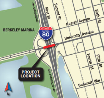 In December 2018, it was reported that Caltrans was seeking public input on plans to replace the
University Avenue overcrossing in Berkeley. The current overpass is only
14 feet, 4 inches high in the westbound direction and 14 feet, 5 inches
high in the eastbound direction, according to Caltrans documents. The
standard height of an overpass is 16 feet, 6 inches. The state agency has
come up with a number of options and is looking for reactions to the
various plans. Caltrans held an open house in Berkeley in late November.
But the agency has also created a public meeting website with videos, renderings, and documents that do a good job explaining the options. Caltrans is looking at four
options: raising the overpass by two feet; replacing the structure;
replacing the structure and adding roundabouts. (Caltrans is considering
two options of this design.) Only the last two options would improve the
flow of traffic, according to Caltrans. The various options will cost
from$33 million to $71 million and would take from 13 months to 25 months
to complete.
In December 2018, it was reported that Caltrans was seeking public input on plans to replace the
University Avenue overcrossing in Berkeley. The current overpass is only
14 feet, 4 inches high in the westbound direction and 14 feet, 5 inches
high in the eastbound direction, according to Caltrans documents. The
standard height of an overpass is 16 feet, 6 inches. The state agency has
come up with a number of options and is looking for reactions to the
various plans. Caltrans held an open house in Berkeley in late November.
But the agency has also created a public meeting website with videos, renderings, and documents that do a good job explaining the options. Caltrans is looking at four
options: raising the overpass by two feet; replacing the structure;
replacing the structure and adding roundabouts. (Caltrans is considering
two options of this design.) Only the last two options would improve the
flow of traffic, according to Caltrans. The various options will cost
from$33 million to $71 million and would take from 13 months to 25 months
to complete.
(Source: BerkeleySide, 12/12/2018)
University Avenue is a four-lane road with a raised median that extends from the Berkeley Marina in the west, to the University of California, Berkeley, in the east. In the WB direction the existing I-80 overcrossing includes two 13 foot wide travel lanes and a 3 foot wide concrete curb. In the EB direction there is a 15 foot wide travel lane, a 12 foot wide shoulder and a 6 foot wide sidewalk. The structure has a 6 foot tall chain link fence on top of the barrier on the southern outer edge of the overcrossing. The overcrossing has a staircase on the southeast side of the structure that leads to an unpaved area underneath the overcrossing. The WB I-80 on and off-ramps intersect with University Avenue. The West Frontage Road and University Avenue intersection is located immediately to the west.
For all build alternatives, work would include the
following: replacing bridge railings, constructing a 6 foot tall chain
link fence on top of the barrier on the outer edges on both sides of the
overcrossing, removing the existing staircase and replacing it with an
Americans with Disabilities Act (ADA) compliant pedestrian ramp structure.
Pavement on I-80 would be replaced under the University Avenue
Overcrossing. All build alternatives would address liquefaction1 by
constructing soil treatments and/or micropiles. Anticipated construction
staging areas are between West Frontage Road and I-80, including the
unpaved areas within the on and off-ramps. Any locations within the
project area disturbed either by construction or staging would be
landscaped after the construction has been completed to increase vertical
clearance.
(Source: Initial Study with Proposed Negative Declaration, November 2018, DISTRICT 4 – ALA – 80 (PM 5.8/5.8))
In August 2019, the CTC approved for future
consideration of funding the following project: 04-Ala-80, PM 5.8/5.8 I-80
in Alameda County. Replace existing overcrossing on I-80 at University
Avenue in the city of Berkeley. (PPNO 1452H). This project is located
above I-80 in the city of Berkeley in Alameda County. The project proposes
to replace the existing University Avenue Overcrossing (UAOC) (Bridge No.
33-0023) with a new structure that will increase the vertical clearance
above I-80. The proposed project will address the need to meet current
required State vertical clearance standards and allow for more efficient
and uninterrupted travel of oversized vehicles without detour and
eliminate potential bridge structure impacts due to insufficient height
clearance. This project also proposes to replace the existing on and
off-ramp structures, replace the existing staircase with an Americans with
Disabilities Act compliant pedestrian ramp structure, replace the concrete
pavement on I-80 under the UAOC and replace bridge railings. This project
is currently programmed in the 2018 SHOPP through the Project
Approval/Environmental Document phase for $3.4 million. This proposed
project is a candidate for Senate Bill 1 funding under the Trade Corridors
Enhancement Program. Construction is estimated to begin in fiscal year
2022-23. The scope, as described for the preferred alternative, is
consistent with the project scope programmed by the Commission in the 2018
SHOPP.
(Source: August 2019 CTC Agenda/Minutes, Agenda
Item 2.2c.(1))
In June 2021, the CTC amended the following project into the 2020 SHOPP:
04-Ala-80 5.9/6.4; 04-CC-680 16.9/17.1. PPNO 1489A ProjID 0415000110 EA
04-3J260. I-80 In Berkeley, from University Avenue to west of Gilman
Street; also on I-680 in Contra Costa County, in Pleasant Hill on Route 680 from Oak Park Boulevard to 0.2 mile north of Oak Park Boulevard (PM
16.9/17.1). Construct outer separation concrete barriers between freeway
and frontage roads.PA&ED $790K; PS&E $1,434K; R/W Sup $64K; Con
Sup $1,396K; R/W Cap $70K; Const Cap $8,398K TOTAL $12,152K. Begin Const:
6/15/2024. Also in June 2021, the CTC approved the following
pre-construction allocation: 04-Ala-80 5.9/6.4; 04-CC-680 16.9/17.1. PPNO
1489A; ProjID 0415000110; EA 3J260. I-80 In Berkeley, from University
Avenue to west of Gilman Street; also in Contra Costa County, in Pleasant
Hill on Route 680 from Oak Park Boulevard to 0.2 mile north of Oak Park
Boulevard (PM 16.9/17.1). Construct outer separation concrete barriers
between freeway and frontage roads. (Concurrent amendment under SHOPP
Amendment 20H-008; June 2021.) Allocation: PA&ED $790,000 (23-24)
(Source: June 2021 CTC Agenda/Minutes, Agenda Item
2.1a.(1a) #7; June 2021 CTC Agenda, Agenda Item 2.5b.(2a)
#7)
Interstate 80/Gilman Street Interchange Improvement Project. (04-Ala-80, PM 6.38/6.95)
The SAFETEA-LU act, enacted in August 2005 as the reauthorization of TEA-21, provided the following expenditures on or near this route:
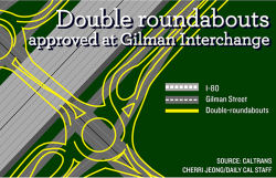 There are plans to reconstruct the Gilman Street interchange with I-80 in Berkeley into a
roundabout. Eight entry points currently lead into the intersection, which
is regulated only by stop signs. Backups at the two intersections, at the
east and west access points for I-80, are among the problematic
interchanges in Berkeley and lead to a slowing of freeway traffic. The
proposal includes two roundabouts. The project will now proceed to an
environmental-impact study in order to assess the consequences of the
proposed construction. The impact study and the engineering and design
work will cost approximately $3.5 million, and the construction costs are
estimated at $9 million to $10 million. Funding for the roundabouts is
contingent on the passage of Measure BB, an Alameda County Transportation
Commission sales tax. If the measure is passed by voters, the
environmental review would be completed by 2017. Engineering and design
work would then be finished by 2018, followed by groundbreaking in 2019.
There are plans to reconstruct the Gilman Street interchange with I-80 in Berkeley into a
roundabout. Eight entry points currently lead into the intersection, which
is regulated only by stop signs. Backups at the two intersections, at the
east and west access points for I-80, are among the problematic
interchanges in Berkeley and lead to a slowing of freeway traffic. The
proposal includes two roundabouts. The project will now proceed to an
environmental-impact study in order to assess the consequences of the
proposed construction. The impact study and the engineering and design
work will cost approximately $3.5 million, and the construction costs are
estimated at $9 million to $10 million. Funding for the roundabouts is
contingent on the passage of Measure BB, an Alameda County Transportation
Commission sales tax. If the measure is passed by voters, the
environmental review would be completed by 2017. Engineering and design
work would then be finished by 2018, followed by groundbreaking in 2019.
(Source: Daily Cal, 10/30/2014)
In February 2018, it was reported that a series of
public meetings were occurring regarding the Gillman Street Roundabout.
One significant change under the current plans is that drivers would no
longer be able to access Eastshore Highway east of the freeway, also
called the frontage road, from Gilman Street going either north or south.
That’s because it would create too much confusion for drivers
accessing the roundabouts, and would also cause traffic to back up too far
on Gilman Street. It would also add to project costs and likely result in
the closure of a business at the northeast corner of Gilman and Eastshore
because the building that houses that business would be in the way of
construction and expansion plans. A new traffic signal is also planned for
Gilman Street at Fourth Street. One piece of the project that’s
still very much under discussion is the location of a U-shaped pedestrian
and cyclist crossing — similar to the one over I-80 at University
Avenue — that could swing either to the north or to the south. The
north-side version would add about $5 million to the project costs but
could one day link up with a bikeway near the Albany border with Berkeley.
The south-side crossing would span .26 of a mile, while the north-side
version would need to be 20% longer to work within the site’s
spacial constraints. The south-side proposal is shorter and cheaper, and
has been preferable to at least certain nearby business owners, but would
still require cyclists and pedestrians to cross Second Street, which is
set to remain an uncontrolled intersection. On the other hand, the idea
has been floated to create an above-grade crossing over the railroad
tracks at Harrison Street that could connect to the north-side
over-crossing; that could eventually make crossing Second unnecessary.
Construction is currently estimated to begin in 2019 and wrap up in 2022.
(Source: Berkeleyside, 2/8/2018)
The 2018 STIP, approved at the CTC March 2018 meeting, appears to allocate $25,784K in FY20-21 for the "Gilman IC Bike/Ped Overcrossing & Access Improvments (ATP)" (PPNO 2323) on I-80, no PM specified. Presumably, this is the new cyclist crossing at the Gilman Interchange.
In January 2019, it was reported that more public
meetings were being held to allow the community a chance to offer feedback
on plans to build two roundabouts in Berkeley on Gilman Street at I-80 to
improve a hairy traffic situation that’s renowned throughout the
area. According to the latest project timeline, final approval is expected
in Summer 2019. Construction is set to begin in late 2020 and finish in
the summer of 2023. The project is expected to cost more than $55 million
and will be funded in large part by the state’s Transportation
Improvement Program and Measure BB. The source for about $12 million in
costs has yet to be determined. As described in the project’s
environmental analysis, the I-80/Gilman Street interchange “is a
four-lane arterial roadway (Gilman Street) with two lanes in the east-west
direction that are intersected with four I-80 on- and offramps.…
Traffic controls on all approaches to Gilman Street consist of stop signs
and pavement markings. These conditions, along with an overall increase in
vehicle traffic, have created poor and confusing operations in the
interchange area.” As far as safety, project documents describe the
westbound off-ramp from I-80 as the most dangerous area of the
interchange, with about two collisions per million vehicles. The plan to
build two roundabouts has generated significant public pushback over the
years, but the project team has said it’s the only feasible
solution. Using traffic signals is not an option “because of
engineering, right-of-way, and cost constraints,” according to
project documents. “Under the Signalized Intersection Alternative,
there would not have been sufficient space for left-turn pockets under the
I-80 undercrossing, and it would have required removal and replacement of
the structure. This would have caused significant traffic impacts and
inconvenience for motorists. In addition, the cost of this alternative
renders it infeasible.” The project is being done by the Alameda
County Transportation Commission, in cooperation with the California
Department of Transportation (Caltrans) and the cities of Berkeley and
Albany.
(Source: Berkeleyside, 1/4/2019)
In October 2019, the CTC had on its agenda the
following project for future consideration of funding: 04-Ala-80, PM
6.38/6.95 I-80 in Alameda County. Construct interchange and roadway
improvements on I-80 at Gilman Street in the cities of Berkeley and
Albany. (PPNO 2323). This project is located from Fourth Street on the
east to west of West Frontage Road at the I-80/Gilman Street interchange
in the cities of Berkeley and Albany in Alameda County. This project
proposes to improve operations for vehicles, bicycles and pedestrians. The
proposed project addresses the need to simplify and improve navigation,
mobility and traffic operations as well as reduce congestion, vehicle
queues and conflicts, improve local and regional bicycle connections,
pedestrian facilities, and improve overall safely at the project location.
The project is fully funded and anticipates funding from local Measure BB,
the State Transportation Improvement Program (STIP), Federal demonstration
funds and SB 1 funds. The project is currently programmed in the 2018 STIP
program for an estimated total of $42.5 million which includes
Construction (capital and support) and Right-of-Way (capital and support).
Construction is estimated to begin in 2021. The scope, as described for
the preferred alternative, is consistent with the project scope programmed
by the California Transportation Commission (Commission) in the 2018 STIP.
(Source: October 2019 CTC Agenda, Agenda Item
2.2c.(1))
In March 2020, the CTC approved the 2020 STIP, which
appears to remove PPNO 2323, Route 80 "Gilman IC Bike/Ped Overcrossing
& Access Improvments (ATP)", replacing it with two items: PPNO 2323A
Phase 1, and PPNO 2323B Phase 2. These are a mix of Caltrans and ACTC
funding.
(Source: March 2020 CTC Agenda, Item 4.7, 2020 STIP
Adopted 3/25/2020)
In May 2020, the CTC approved the following STIP
funding requests:
(Source: May 2020 CTC Agenda; Agenda Item 2.5c.(5))
In August 2020, the CTC approved the following
financial allocation: $16,816,000. 04-Ala-80 PM 6.4/6.8. PPNO 04-2323A
ProjID 0420000287 EA 0A771. I-80/Gilman Interchange
Bicycle/Pedestrian Over-crossing and Access Improvements (Phase 1:
Bicycle/Pedestrian Over-crossing). In the city of Berkeley, along
Gilman Street. Construct a bicycle/pedestrian Overcrossing over I-80.
$1,897,000 Con Eng; $14,919,000 Const.
(August 2020 CTC Agenda, Agenda Item 2.5c.(1) #1)
In September 2020, it was reported that the project to
build two roundabouts to replace the chaotic intersections on Gilman
Street at I-80 in West Berkeley is set to begin by the end of 2020,
according to project materials. A September factsheet from the Alameda
County Transportation Commission says the double roundabouts are needed
because of “higher than average rates of injury collisions”
and “significant roadway deficiencies,” among other factors.
The project is slated to be completed in two phases, starting with a
pedestrian and bicycle overcrossing to the south. Construction for that
piece of the project is set to begin late in 2020 and wrap up by 2023,
according to project materials. The second phase of the project involves
improvements to the intersections and nearby local streets; better
crossings for pedestrians and cyclists; the closure of a gap in the Bay
Trail; and safety upgrades at the nearby Union Pacific railroad crossing.
Work on that phase is set to begin in summer 2021 and end in 2023. The
project is currently estimated to cost about $63 million, according to
project materials. More than $40 million of the budget is coming from the
state.
(Source: Berkeleyside, 9/23/2020)
 In April 2021, it was reported that seven years after the
concept was first presented to the public, Caltrans is set to begin work
on installing two roundabouts and a pedestrian/bike bridge by the Gilman
Street interchange at I-80. Work on a bridge to the south of the exit will
begin in May 2021 and work on the roundabouts will start in November 2021.
The two elements are scheduled to be completed in 2023. The work is
currently estimated to cost about $75 million. The state will contribute
$47 million of the budget, Measure BB will provide $16 million, Berkeley
and East Bay Municipal Utility District will contribute $1 million. There
is still a $10 million gap in funding, according to project documents.
Bikers and walkers will be able to go over or under the freeway. The bike
bridge takes many design elements from the bike bridge on the newer
section of the Bay Bridge. There will be two bike lanes, one for each
direction, as well as a lane for pedestrians. People walking under the
freeway also will have an improved experience. Caltrans will be enclosing
the open areas under the underpass with concrete walls (space that once
held many unhoused individuals). It will add lighting so bright that it
always appears to be daylight under the freeway. There will also be two
bike lanes at grade and a separate lane for walkers. Caltrans is also
improving bicycle access from the bike bridge to Fourth and Gilman
streets. There will be a bidirectional bike path on the south side of
Gilman as well as a new signaling system to allow cyclists to cross over
Gilman Street and connect with bike paths going to Harrison Park, the Gabe
Catalfo soccer fields, University Village in Albany. Currently, there are
only bike lanes on Gilman east of Second Street. The project will also
close a gap in the Bay Trail between Berkeley and Golden Gate Fields.
In April 2021, it was reported that seven years after the
concept was first presented to the public, Caltrans is set to begin work
on installing two roundabouts and a pedestrian/bike bridge by the Gilman
Street interchange at I-80. Work on a bridge to the south of the exit will
begin in May 2021 and work on the roundabouts will start in November 2021.
The two elements are scheduled to be completed in 2023. The work is
currently estimated to cost about $75 million. The state will contribute
$47 million of the budget, Measure BB will provide $16 million, Berkeley
and East Bay Municipal Utility District will contribute $1 million. There
is still a $10 million gap in funding, according to project documents.
Bikers and walkers will be able to go over or under the freeway. The bike
bridge takes many design elements from the bike bridge on the newer
section of the Bay Bridge. There will be two bike lanes, one for each
direction, as well as a lane for pedestrians. People walking under the
freeway also will have an improved experience. Caltrans will be enclosing
the open areas under the underpass with concrete walls (space that once
held many unhoused individuals). It will add lighting so bright that it
always appears to be daylight under the freeway. There will also be two
bike lanes at grade and a separate lane for walkers. Caltrans is also
improving bicycle access from the bike bridge to Fourth and Gilman
streets. There will be a bidirectional bike path on the south side of
Gilman as well as a new signaling system to allow cyclists to cross over
Gilman Street and connect with bike paths going to Harrison Park, the Gabe
Catalfo soccer fields, University Village in Albany. Currently, there are
only bike lanes on Gilman east of Second Street. The project will also
close a gap in the Bay Trail between Berkeley and Golden Gate Fields.
(Source: Berkeleyside, 4/12/2021)
In June 2021, the CTC approved an allocation of
$21,968,000 for the State-Administered State Transportation Improvement
Program (STIP) I-80/Gilman Interchange Bicycle/Pedestrian Over-crossing
and Access Improvements (Phase 2: Interchange) project (PPNO 2323B, ProjID
0420000288; EA 0A772; 04-Ala-80 6.4/6.8). The project is on I-80, In the
city of Berkeley, along Gilman Street, from Fourth Street to about 350
feet west of the West Frontage Road. Construct double roundabout and
roadway access to and from the roundabouts. (CONST savings of $2,166,000
and $290,000 in CON ENG savings of to be returned to Alameda County
regional shares.) (Future consideration of funding approved under
Resolution E-19-82; October 2019.) (Contribution from other sources:
$1,538,000 (CON ENG) and $8,198,000 (CONST) in local funds.) Allocation:
CON ENG $3,000,000 $2,710,000; CONST $21,424,000
$19,258,000.
(Source: June 2021 CTC Agenda, Agenda Item
2.5c.(1))
In April 2023, it was reported that a seven-week
closure of the Gilman Street approach to I-80 started 5/1/2023 and would
last through 6/21/2023. The closure was between Fourth and Second streets,
but drivers would be able to access businesses on the closed portion of
Gilman, as well as those on Fourth and Second streets, such as the
Berkeley Transfer Station and Recycling Center. The closures are part of
the multi-year $75 million project redesigning the chaotic intersection
drivers must navigate to exit or enter I-80 at Gilman Street. Plans
include two new roundabouts to better manage car traffic, safety
improvements where Gilman crosses the Union Pacific Railroad tracks and a
new bicycle and pedestrian bridge that has taken shape over the busy
freeway. Work on the bridge is scheduled to be completed in 2023, while
the rest of the interchange project is expected to wrap up in 2024.
(Source: Berkeleyside, 5/1/2023)
In July 2023, it was reported that Eastshore Highway
has been temporarily closed between Gilman Street and Harrison Street, and
will remain blocked off until September 2023. Caltrans has temporarily
redesigned Second Street, a block east of the freeway frontage road, to
handle two-way traffic and serve as a detour around the closure. Caltrans
completed in Summer 2023 on a new protected bicycle track and railroad
crossing along Gilman Street, which is part of a $75 million project that
will eventually include two new traffic circles to handle cars headed to
and exiting from I-80.
(Source: Berkeleyside, 7/31/2023)
In December 2023, the CTC approved for future
consideration of funding the following project for which a Negative
Declaration (ND) and Addenda have been completed: Interstate 80/Gilman Street Interchange Improvement Project. I-80 in Alameda
County. Improve operations for vehicles, bicycles, and pedestrians where
I-80 and Gilman Street intersect. The purpose of the project is to
simplify and improve navigation, mobility, and traffic operations, reduce
congestion, vehicle queues and traffic, bicycle, and pedestrian conflicts,
improve local and regional bike facilities, and improve safety at the
I-80/Gilman Street interchange, in Alameda County. (04-Ala-80, PM
6.38/6.95; PPNO 04-2323). The project is located on I-80, from PM 6.38 to
PM 6.95, in Alameda County. The Department proposes to improve operations
for vehicles, bicycles, and pedestrians where I-80 and Gilman Street
intersect. The purpose of the project is to simplify and improve
navigation, mobility, and traffic operations, reduce congestion, vehicle
queues and traffic, bicycle, and pedestrian conflicts, improve local and
regional bike facilities, and improve safety at the I-80/Gilman Street
interchange. The project is currently programmed in the 2020 State
Transportation Improvement Program (STIP). The total programmed amount,
which includes Right of Way (Capital), and Construction (Capital) is
$3,889,000. Construction began in 2021-22. The scope, as described for the
preferred alternative, is consistent with the project scope as programmed
by the Commission in the 2020 STIP. A copy of the ND has been provided to
Commission staff. The Commission approved the project for future
consideration of funding on October 10, 2019, under Resolution E-19-82.
Since the approval of the ND, there have been changes to the project and
Addenda were prepared pursuant to CEQA. These changes include splitting
the project into 2 phases after the ND was approved. The first Addendum,
which was prepared on June 19, 2020, documented the split and described
the need for additional temporary construction easements for Phase 1 that
were not previously identified in the ND. The second Addendum, which was
prepared on April 13, 2021, described the work that would occur in Phase
2, such as removal of a previously proposed tidal flap gate; extension of
irrigation lines and electrical conduits; changes in the number of
proposed parking spaces; additional use of a property outside of
Department Right of Way; Union Pacific Railroad improvements / changes;
signal installation; and water line extensions. The project changes do not
meet the criteria outlined in CEQA Guidelines Section 15162 to prepare a
Subsequent ND. The Department subsequently completed Addenda to the ND
pursuant to CEQA. The Department has approved this project for
construction. This approval and the Addenda will satisfy the environmental
requirements for this stage of the planning process.
(Source: December 2023 CTC Agenda, Agenda Item 2.2c.(2))
In December 2023, the CTC considered a supplemental
allocation request of $3,727,000 (137.5 percent increase) in Construction
Support for the STIP I-80/Gilman Interchange Bicycle/Pedestrian
Over-crossing and Access Improvements (Phase 2: Interchange) project on
I-80: 04-Ala-80 6.4/6.8. PPNO 04-2323B; ProjID 0420000288; EA 0A772. I-80
In the city of Berkeley, along Gilman Street, from Fourth Street to about
350 feet west of the West Frontage Road. Construct double roundabout
and roadway access to and from the roundabouts. Supplemental funds are
needed to Complete Construction. CEQA - ND, 6/21/2019; Re-validation
4/13/2021 NEPA - FONSI, 6/21/2019; Re-validation 4/13/2021 Future
consideration of funding approved under Resolution E-19-82; October 2019.
Total revised amount $6,908,000. Concurrent addendum for the previously
approved Future Consideration of Funding under Resolution E-23-157A;
December 2023. The project realized cost increases due to additional
survey efforts, delays from utility conflicts and railroad impacts,
differing site conditions, additional coordination with neighboring
projects, extended contractor’s operations, and the use of
consultant staff. These events and changes have resulted additional
work. The construction survey effort for the project was significantly
underestimated given the complex staging for the two roundabouts which
involved the on and off-ramps, frontage roads, and Gilman Street, as well
as work involving Union Pacific Railroad (UPRR), City, East Bay Municipal
Utility District, Pacific Gas and Electric, and Golden Gate Fields
(GGF). There was also additional work for driveways and sidewalks on
Gilman Street outside of State’s right of way. The actual
survey effort will be approximately four times higher than anticipated.
These additional resources amount to $800,000. The work required the
closure of Gilman Street for 50 calendar days for UPRR construction.
The original closure date in the Fall of 2022 could not be met due to long
lead order times for critical elements such as signal poles, fencing, and
controller components. UPRR could not provide crews until May 2023
due to other emergency work. The project performed out of sequence
work on critical and non-critical activities in order to mitigate this
delay. However, most re-sequenced operations were impacted by
differing site conditions or other delays, which resulted in negligible
savings to the schedule. The net result was an 8-month delay and
additional support costs. These additional resources amount to
$1,600,000. The project has experienced dozens of differing site
conditions due to the work on local streets in older, urbanized areas
resulting in significantly higher support costs. The project has
encountered unanticipated hazardous waste in the spoils from the utility
and drainage work performed in these areas. This has increased the
support cost due to additional testing and tracking these sites, and
processing payments. To keep the project moving, the Department has
utilized task orders for soil sampling and testing. The hazardous
soil required special handling and disposal and resulted in project delays
and inefficiencies.
(Source: December 2023 CTC Agenda, Agenda Item 2.5e.(7))
In August 2020, the CTC authorized relinquishment of right of way,
consisting of collateral facilities, in the City of Albany along Route 80
on Cleveland Avenue and Washington Avenue (04-Ala-80-PM R7.4) under the
terms and conditions as stated in the Freeway Agreement dated September 7,
1994. The City, by Resolution No. 2020-32, signed April 10, 2020, agreed
to waive the 90-day notice requirement and accept title upon
relinquishment by the State.
(Source: August 2020 CTC Agenda, Agenda Item 2.3c)
Central Avenue Interchange (~ CC 0.177)
The SAFETEA-LU act, enacted in August 2005 as the reauthorization of TEA-21, provided the following expenditures on or near this route:
In March 2020, the CTC approved the 2020 STIP, which
appeared to continue funding for PPNO 2025H "Rt 80/Central Ave IC, Ph2
(local rd realign)". This may be a local road off I-80 that feeds into the
interchange. $5,900K was allocated in prior year programming; $1,873K in
FY21-22.
(Source: March 2020 CTC Agenda, Item 4.7, 2020 STIP
Adopted 3/25/2020)
I-80 Integrated Corridor Mobility Project (~ CC 2.969 to CC 13.796)
In February 2012, Caltrans began holding open houses regarding the I-80 Integrated Corridor Mobility project. The project is designed to reduce congestion on I-80, including long delays and stop-and-go traffic; congestion-related traffic collisions; long emergency response times; unreliable commute times; and cut-through traffic. The agency plans a number of steps to achieve that goal, with the most noticeable being the addition of metering lights at onramps along I-80, and corresponding changes to signals on San Pablo Avenue (CC 2.969) and thoroughfares leading to I-80. In addition, Caltrans would add high-occupancy vehicle bypass lanes at ramp meters. The metering lights will use adaptive metering that can be activated as real-time conditions warrant, and also work in concert with traffic signals on streets leading to the ramps to control the number of cars trying to enter the freeway. In March 2012, the CTC approved $95.3 million in funding for this project.
In October 2012, it was reported that further progress
had been made on the I-80 Integrated Corridor Mobility project. The $80
million project is "a state-of-the-art technological solution to managing
congestion and improving traffic conditions," according to the Alameda
County Transportation Commission. A new type of adaptive metering light to
be installed at all of the corridor's 40 onramps will allow entrance at
rates determined by the current flow of traffic. Buses will have priority
for entrance, using a transponder to turn the light green, as they do now
on San Pablo Avenue. The freeway itself will have detectors to accurately
monitor traffic; new signs on I-80 and San Pablo and other major
connectors will inform motorists of current conditions, blocked lanes,
speed recommendations and alternative routes; and updates will be
available via car radio announcements. Work on most phases of the project
has already started, with the last scheduled for completion in mid-2015.
(Source: Contra-Costa Times, 10/22/12)
In August 2014, it was reported that Caltrans is
working to turn I-80 between Richmond and Emeryville into a "smart
freeway". Much of this work is not visible; the primary visual element are
11 huge gantries - metal sign frames - that stretch across all westbound
lanes of the freeway in the most consistently congested and
collision-ridden stretch, from Richmond to Emeryville. Those gantries will
hold an array of signs giving drivers information to help them steer clear
of accidents, debris and blocked lanes. It will even let them know if it
would be faster to take public transit. More signs will be scattered along
the rest of the 19.5-mile stretch of the project between the Carquinez
Bridge in Crockett and the Bay Bridge. When it's done in 2015, the I-80
Smart Corridor project will feature 133 large high-tech signs, but it's
about much more than signs. The system will gather information from
networks of sensors and cameras on the freeway, major side streets and
ramps. That data, with the help of humans in the Caltrans Traffic
Management Center in Oakland, will be used to meter traffic at all 44
on-ramps along the corridor, adjust the signs along I-80 and control
traffic signals on nearby arterial streets to help combat congestion
there, and steer it back toward the freeway. On San Pablo Avenue (Route 123), which parallels I-80 and becomes a popular alternate route when I-80
backs up, the operators will be able to speed up or slow down traffic
signals to help keep traffic flowing. There are also signals to give
transit buses priority. "Trailblazer" signs at major arterial streets that
connect San Pablo to the freeway will direct drivers back to the freeway
with the message "To I-80" and an arrow pointing the way. The project will
also feature ramp metering, which is designed to keep traffic on the
freeway moving while preventing it from backing up onto local streets, as
well as improved traffic and transit information that can be displayed on
the freeway to let drivers know when they'd be better off to park their
cars and take BART. All pieces of the system are designed to work
together. Construction of the system started in 2012, but much of it
involved installing fiber-optic cables, working on traffic signals,
manufacturing signs and creating computer applications. Work on San Pablo
Avenue has been completed, though the trailblazer signs are covered, and
the large freeway signs have all been manufactured and are being tested in
a San Leandro warehouse.
(Source: SF Gate, 8/4/14)
In July 2016, it was reported that Caltrans has begun
to unveil its I-80 "smart highway" project, phasing in 20 miles' worth of
electronic improvements from the Carquinez Bridge to the Bay Bridge. The
$79 million SMART Corridor project is the most intensive one in the state,
with advanced metering lights and lane-closure warnings and even variable
speed-limit signs that can be lowered to 55 mph, or 30 mph, or whatever
conditions warrant. All of these real-time traffic-monitoring tools are
located on the westbound side of the notorious freeway that carries
270,000 vehicles each weekday. The primary goal is to reduce the accident
rate on this stretch; it's twice as high as the statewide average for
comparable highways such as I-405 in Southern California. Caltrans
engineers also hope to adjust and smooth the flow of traffic. Motorists
will see large traffic information boards light up from Vallejo through
Contra Costa and Alameda counties and onto the Bay Bridge approach in
Berkeley-Emeryville. There will be metering lights at 44 ramps. Traffic
signals will be adjusted on San Pablo Avenue to help motorists when they
use that parallel thoroughfare as a detour; signs will activate on San
Pablo when an incident has cleared and it's safe to return to the freeway.
The price tag, while hefty, is many millions less than making the freeway
10 or 12 lanes. A similar effort can be seen in the I-15 smart corridor.
The ramp meters will manage the flow of vehicles onto I-80 in real time,
with traffic monitors in Caltrans' operation center in Oakland changing
the messages on all those new signs almost instantly, making it safer for
drivers to merge onto I-80 and alleviating backups on local streets.
(Source: East Bay Times, 7/10/2016)
In September 2016, it was reported that the Smart
Highway project had been fully and officially, activated. The Smart
Corridor project cost $79 million and includes 159 electronic signs
mounted on 11 structures over the roadway. How it works is simple. Green
arrows over your lane mean you’re good to go, a yellow X over your
lane means there’s a problem ahead and you need to move lanes. A red
X means a crash is blocking the lane and you need to move lanes. The Smart
corridor project is designed to reduce secondary accidents, according to
Caltrans officials.
(Source: CBS San Francisco, 9/19/2016)
San Pablo Interchange Improvement Project (Phase 1: 04-CC-80 PM 4.13; Phase 2: 04-CC-80 PM 3.8/5.3)
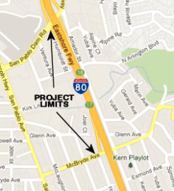 In June 2012, the CTC approved for future consideration of funding project in Contra Costa
County will reconstruct the I-80/San Pablo Dam Road Interchange. It will
also relocate the westbound I-80/El Portal Drive on-ramp, build a new
westbound auxiliary lane from the relocated westbound El Portal Drive
on-ramp to the San Pablo Dam Road off-ramp, add a frontage road between
the I-80/San Pablo Dam Road on-ramp and McBryde Avenue and close the
McBryde Avenue off-ramp, reconstruct the pedestrian overcrossing at
Riverside Avenue, and construct pedestrian and bicycle facility
improvements. The total estimated cost for the entire I-80/San Pablo Dam
Road Interchange Project is $113,889,000 for capital and support. The
project will be built in four phases. Phases 1 and 2 are fully funded.
Phase 1 will construct the Riverside Boulevard Pedestrian Overcrossing
over I-80 and complete right of way for the overall project. Phase 1 is
programmed in the 2012 State Transportation Improvement Program (STIP).
The scope for Phase 1, as described for the preferred alternative, is
consistent with the project scope programmed in the 2012 STIP.
Construction for Phases 1 and 2 is estimated to begin in Fiscal Year
2013-14.
In June 2012, the CTC approved for future consideration of funding project in Contra Costa
County will reconstruct the I-80/San Pablo Dam Road Interchange. It will
also relocate the westbound I-80/El Portal Drive on-ramp, build a new
westbound auxiliary lane from the relocated westbound El Portal Drive
on-ramp to the San Pablo Dam Road off-ramp, add a frontage road between
the I-80/San Pablo Dam Road on-ramp and McBryde Avenue and close the
McBryde Avenue off-ramp, reconstruct the pedestrian overcrossing at
Riverside Avenue, and construct pedestrian and bicycle facility
improvements. The total estimated cost for the entire I-80/San Pablo Dam
Road Interchange Project is $113,889,000 for capital and support. The
project will be built in four phases. Phases 1 and 2 are fully funded.
Phase 1 will construct the Riverside Boulevard Pedestrian Overcrossing
over I-80 and complete right of way for the overall project. Phase 1 is
programmed in the 2012 State Transportation Improvement Program (STIP).
The scope for Phase 1, as described for the preferred alternative, is
consistent with the project scope programmed in the 2012 STIP.
Construction for Phases 1 and 2 is estimated to begin in Fiscal Year
2013-14.
In May 2015, the CTC deferred an allocation of $15,000,000 towards this project. Additional funding is $6,227,000 from other sources. Although the local agency is ready to proceed with this project, the deferral was recommended because current year capacity is reserved for projects programmed in FY 2014-15.
In April 2016, it was reported that elected officials
and local transportation leaders gathered on 4/1/2016 to celebrate the
beginning of reconstruction work on I-80’s more than 50-year-old San
Pablo Dam Road interchange. Planning for this project began almost exactly
10 years ago; however, updating the infrastructure has been discussed as a
priority of local leaders for longer than that — more than 20 years.
Even after securing funding sources, the project is still $60 million
short of what will be needed to continue with a second phase of the
reconstruction after the first phase is completed, which is expected to be
in spring 2017. The project’s first phase was paid in part by a $12
million infusion of Measure J funds, a continuation of a transportation
sales tax that Contra Costa County voters passed in 2004. There was also
an $8 million commitment from the Metropolitan Transportation Commission
through its toll-based Regional Measure 2. State agencies and the city of
San Pablo are helping pay for the project as well. During the
project’s first phase, construction crews will relocate the
highway’s El Portal Drive on-ramp (CC 5.26) and extend the extra
lane between that onramp and the San Pablo Dam Road off-ramp. A pedestrian
pathway on Riverside Avenue that crosses above the highway will also be
redone in a way that transportation officials expect to provide safer
access to Riverside Elementary School.
(Source: KRON-TV, 4/1/2016)
In March 2017, it was reported that a new El Portal
on-ramp to westbound I-80 opened on March 20, 2017. The new on-ramp is
located to the north of El Portal Drive. When it opened, the old on-ramp
at El Portal Drive will close permanently. Signage will help redirect
motorists from the old to the new ramp. The new westbound on-ramp, along
with the extension of the auxiliary lane of westbound I-80 between the San
Pablo Dam Road off-ramp and the El Portal Drive on-ramp, are part of the
$42 million first phase of the CCTA-led I-80/San Pablo Dam Road
Interchange Reconstruction Project. Caltrans, the Metropolitan
Transportation Commission (MTC), and the City of San Pablo are partners in
the $118.8 million project. The first phase also includes the
reconstruction of the Riverside Avenue pedestrian overcrossing, which
opened to the public in October 2016.
(Source: East Bay Times, 3/15/2017)
The 2018 STIP, approved at the CTC March 2018 meeting, appears to delay the R/W acquisition phase for Phase 2 from FY19-20 to FY20-21. The Phase 2 project (PPNO 242K) includes acquisition of necessary Right of Way for Phase 2 scope of work which includes: Construct McBryde Connector Road, reconstruct San Pablo Dam Road overcrossing and ramps, construct Wild Cat Creek Bridge, widen San Pablo Dam Road and realign Amador Street.
In January 2021 the CTC received notice of, and in
March 2021 the CTC approved, a SHOPP amendment to delete the I-80 San
Pablo Dam Interchange – Phase 2 (Right of Way (R/W) only) project
(PPNO 0242K) (04-CC-80 PM 3.8/5.3) and reprogram these funds to a new
project: – Bollinger Canyon Road–Iron Horse Trail Bike and
Pedestrian Overcrossing project (PPNO 0242M) off the state highway system
in Contra Costa County. The background to the amendment, which was noticed
in December 2020, notes that the I-80/San Pablo Dam Interchange –
Phase 2 (R/W only) project (PPNO 0242K) is currently programmed in the
STIP with $9,200,000 in Regional Improvement Program (RIP) funds for the
R/W phase only. Due to a significant funding shortfall and a lack of local
matching funds, the Contra Costa County Transportation Agency (CCTA) has
not been successful in securing a complete funding plan for this project.
Although this remains a high priority project, CCTA is unable to proceed
with the R/W phase at this time due to a lack of required funding. In
order to utilize these STIP funds in a timely manner, CCTA is proposing to
reprogram $9,200,000 in RIP funds from the I-80/San Pablo Dam Interchange
– Phase 2 (R/W only) project (PPNO 0242K) to the Bollinger Canyon
Road–Iron Horse Trail Pedestrian and Bicycle Overcrossing project
(PPNO 0242M). This project has already completed the environmental phase
and is currently in the design phase. Once completed, this project will
improve access and safety for pedestrians and bicyclists on the Iron Horse
Trail and will also create a more pedestrian-friendly environment at the
Bollinger Canyon Road crossing in the City of San Ramon. The MTC concurred
with the changes.
(Source: January 2021 CTC Agenda, Agenda Item
2.1b.(1); March 2021 CTC Agenda, Agenda Item 2.1a.(2))
In May 2023, the CTC received notice of a STIP
amendment to add a new project to program $900,000 in Plans,
Specifications, and Estimates (PS&E) and $2,900,000 in Right of Way
(RW) funds in Fiscal Year 2023-24, for the I-80/San Pablo Dam Interchange
- Phase 2 Project (PPNO 0242K), in Contra Costa County. The I-80/San Pablo
Dam Interchange - Phase 2 Project (PPNO 0242K) proposes to construct a
McBryde Avenue Connector Road, reconstruct the San Pablo Dam Road (SPDR)
overcrossing and ramps, construct Wildcat Creek Bridge, widen SPDR and
realign Amador Street and add missing sidewalks east of the SPDR
interchange. The new SPDR structure will provide standard vertical
clearance and standard shoulders on I-80, add Americans with Disabilities
Act (ADA) compliant curb ramps at ramp intersections and a new
intersection at SPDR/Amador Street. As the implementing agency for the
project, CCTA has been working with the Department and other stakeholders
to secure Senate Bill 1 (SB 1) Trade Corridor Enhancement Program (TCEP)
funds to advance the project. In November 2022, the Department submitted
the project application seeking $19,700,000 million in SB 1 TCEP funds,
with CCTA committed to providing matching funds of $3,800,000 million from
its STIP regional shares: $900,000 for PS&E and $2,900,000 for RW. The
funds are requested to be programmed in 2023-24, to match the programming
year of the SB 1 TCEP funds. The project will not be programmed if CCTA is
not successful in the competitive TCEP process. In June 2023, the CTC
approved the amendment.
(Source: May 2023 CTC Agenda, Agenda Item 2.1b.(8); June 2023 CTC
Agenda, Agenda Item 2.1a.(10))
In June 2023, the adoption of the 2022 Trade Corridor
Enhancement Program included the following description of a program: The
Interstate (I)-80/San Pablo Dam Road Interchange Improvements Phase 2 will
reconstruct the existing I-80/San Pablo Dam Road Interchange by upgrading
the overcrossing structure to current standards, modifying the McBryde
Avenue off-ramp to eliminate weaving on westbound I-80, and providing
improved pedestrian and bicycle lanes and facilities. The recommended
Trade Corridor Enhancement Program funds are for the design and
right-of-way for this project.
(Source: June 2023 CTC Agenda, Agenda Item 4.5)
In July 2023, it was reported that the CTC allocated
$19.7 million to fund phase two of the I-80/San Pablo Dam Road Interchange
Improvements, which will upgrade the overcrossing structure to current
standards and provide improved pedestrian and bicycle facilities in the
city of Richmond in Contra Costa County.
(Source: Construction Equipment Guide, 7/24/2023)
In October 2023, the CTC approved the following
allocation for the locally-administered multi-funded TCEP/STIP I-80/San
Pablo Dam Interchange – Phase 2 project: $23,500,000. 04-CC-80
3.8/5.3. PPNO 04-0242K; ProjID 0413000404; EA 0A082. I-80/San Pablo
Dam Interchange - Phase 2. City of San Pablo, Contra Costa Co.
I-80/San Pablo Dam Road (SPDR) Interchange - Phase 2. Project will
construct McBryde connector road, reconstruct SPDR overcrossing and ramps,
construct Wildcat Creek Bridge, widen SPDR and realign Amador Street &
add missing sidewalks east of SPDR interchange. The new SPDR structure
will provide standard vertical clearance and standard shoulders on I-80,
add ADA compliant curb ramps at ramp intersections & new intersection
at SPDR/Amador Street. CEQA - MND, 02/25/2010; Re-validation 04/09/2014
NEPA - FONSI, 02/25/2010; Re-validation 04/09/2014 Future consideration of
funding approved under Resolution E-12-33; June 2012. Contribution from
other sources: $500,000. Concurrent SB 1 TCEP Baseline Agreement under
Resolution TCEP-P-2324-01B; October 2023.
(Source: October 2023 CTC Agenda, Agenda Item 2.5s.(7))
In Mid-May 1969, the land collapsed under the I-80 between Pinole's Hilltop Drive ramp and the Appian Way ramp (~ CC 5.931 to CC 7.603). Eventually, all the lanes of the freeway but one, broke off. It began in Tara Hills subdivision of homes nearby the freeway on Shamrock Drive. Specifically, a 500-ft section of I-80 collapsed halting SB traffic. Pictures of the collapse, detour, and rerouting of 6 lines may be found at http://collections.museumca.org/.
Carquinez Straights Bridge (~ CC 13.616 to SOL 0.392)
There were two projects to retrofit and replace portions of the Carquinez Straights Bridge. This is because the Carquinez Bridges do not meet current seismic design or traffic safety standards:
In mid-March 2006, after nearly 79 years on the job, the 1927 span of the Carquinez Bridge was retired. This was the Bay Area's first modern steel bridge, and is the center bridge of the three that carry I-80 traffic over the Carquinez Strait. It opened May 21, 1927, and was rendered unnecessary with the opening of the westbound Al Zampa Bridge in 2003. The original span's age prompted transportation officials to replace it rather than strengthening it against earthquakes. Crews have begun removing the deck of the 1927 bridge, and in a couple of weeks will lower part of the span onto barges and ship it to a nearby yard for final dismantling. The rest of the span will be lowered later, and the towers and piers are expected to disappear by late 2007. The bridge cannot be quickly demolished because the new Al Zampa Memorial Bridge sits to the west of the old bridge, and a 1958 span carrying westbound I-80 traffic sits to the east, leaving only so much room for crews to maneuver. Furthermore, workers also must be careful not to drop anything into the waters below, which serve as a salmon run and natural habitat for delta smelt. Parts of the old span are listed on the National Register of Historic Places and will be saved. After the spans have been lowered and removed by barge, attention will turn to the three towers, with their attached roadways, and the approaches to the bridge. Crews will install temporary support towers on the Crockett side to support the bridge approach during the dismantling. Then, using cranes, they'll remove the three towers and, finally, the approaches. Work is scheduled to be finished in September 2007. The cost of taking apart the bridge -- essentially in reverse order of its construction, according to Haus -- will cost an estimated $18 million, $10 million more than it cost to build.
In February 2010, the toll increased to $5 at all times on the Dumbarton, San Mateo, Richmond-San Rafael, Carquinez, Benicia-Martinez and Antioch bridges. In July 2010, the toll will be extended to carpoolers, who will pay $2.50.
In June 2014, it was reported that a seismic expansion joint on the westbound Carquinez Bridge - similar to a dozen used on the skyway portion of the new Bay Bridge eastern span - has cracked after less than 10 years of pounding by heavy trucks. The cracking on the joint of the $240 million steel suspension span - which was finished in 2003 and crosses the Carquinez Strait near Vallejo - started showing up in 2012. Another five of the 15 expansion joint supports on the bridge are showing signs of premature wear.
In September 2019, it was reported that the Metropolitan Transportation
Commission gave the green light on a $4 million contract with a consultant
for an all-electronic tolling system for all bay area bridges, except the
Golden Gate which is its own district and has already gone cashless..
Drivers must pay with FasTrak only. For those without FasTrak, cameras
will capture your license plate and you'll get a bill in the mall. The
commission said it will save drivers time and the agency money. Drivers
won't have to slow down to squeeze through a toll booth. Toll booths will
be removed. The commission anticipates realistically it could take up to
five years for the system to go into effect. The Carquinez Bridge will
likely be the first to go cashless. MTC said engineers say it's a good
test bed to move faster on the others. The Bay Bridge will be likely be
last since it's the busiest. The toll authority first authorized the move
to all-electronic, open road tolling in December 2018. The consultants
jsut approved will be responsible for developing the toll system’s
specifications, providing oversight of the program’s implementation,
reviewing design plans, and help to develop policies for all-electronic
tolling. Bridges under the purview of the toll authority include the
Antioch Bridge, Benicia-Martinez Bridge, Carquinez Bridge, Dumbarton
Bridge, Richmond-San Rafael Bridge, San Mateo-Hayward Bridge and the San
Francisco-Oakland Bay Bridge.
(Source: KTVU, 9/1/2019; SFExaminer,
9/4/2019)
Route 80/Route 29 Separation Bridge Replacement (04-Sol-80 PM 0.8/1.6)
The following project was included in the final adopted 2018 SHOPP in March 2018: PPNO 1452F. 04-Solano-80 1.1. Route 80 In Vallejo, at Route 80/Route 29 Separation Bridge No. 23-0087. Replace bridge. Begin Con: 1/15/2021. * Const, * R/W, * PS&E, * R/W Sup, * Con Sup phase(s) are NOT authorized. Total Project Cost: $19,056K.
In October 2020, the CTC approved the following
allocation for Projects with Cost Increase Greater than 20 percent:
$24,798,000 for Solano 04-Sol-80 PM 0.8/1.6 PPNO 04-1452F ProjID
0417000031 EA 2K840. I-80 In Vallejo, at Route 80/Route 29 Separation
Bridge No. 23-0087. Outcome/Output: Replace bridge with strengthened deck
and approaches for higher permit load rating and increased vertical
clearance, improve drainage, and construct Class 1 bike path on northbound
Route 29. (CEQA - CE, 5/11/2018; Re-validation 5/15/2020) (NEPA - CE,
5/11/2018; Re-validation 5/15/2020) The $24,798,000 allocation represents
an allocation of $20,498,000 for construction capital and $4,300,000 for
construction support. The project was programmed in 2018 for $12,300,000
in construction capital and $2,600,000 in construction support for
construction in 2019-20. In June 2020, the project received a construction
allocation extension for four months. And also, in June 2020, the Plan
Specifications and Estimate (PS&E) phase was completed based on the
most recent Engineers Estimate (EE), which was completed on June 15, 2020,
with the updated project construction capital cost of $20,498,000, an
increase of $8,198,000 or 66 percent over the programmed funds. The
significant Construction Capital cost increases resulted from a necessary
redesign of the staging plans that was completed in FY 2019-20. The
redesign resulted from the final constructability review that took place
near the end of fiscal year 2018-19, which identified the need for more
extensive construction staging to address a grade separation of up to 5
feet between westbound and eastbound lanes. The initial staging plan
consisting of mostly restriping to shift six traffic lanes had to be
redeveloped into six separate stages to shift traffic to the middle, the
western, and the eastern segments of the bridge approaches while each of
the three respective bridge deck sections are being replaced. Most of the
construction capital cost increases are due to the need for more asphalt
to regrade the pavement for each stage to allow shifting of traffic lanes
($3,425,000), temporary drainage ($1,300,000), temporary electrical and
traffic control items, such as COZEEP and TMS ($2,813,000), and
bridge/concrete barrier items ($660,000). This complex staging contributed
to the number of working days almost doubling, and turning a one-season
project into a two-season project. Construction support is a time
sensitive cost and proportional to project duration. Since the working
days expanded from 250 days to 425 days, the increase from $2,600,000 to
$4,300,000 reflects the added resources for a longer construction duration
and more extensive traffic handling effort for the six separate stages of
construction.
(Source: October 2020 CTC Agenda, Agenda Item
2.5d.(1))
In June 2021, it was reported that Caltrans was
beginning pre-construction work for the I-80/Route 29 Separation Bridge
project in Vallejo. During this project the following I-80 onramps near
Maritime Academy Drive in Vallejo are scheduled to be closed between June
2021 until approximately 2023. During these I-80 ramp closures, motorists
are advised to use Magazine Street onramp and offramp and other I-80
entrances to access I-80 in Vallejo. The westbound I-80 offramp at Sequoia
Ave. will remain open. The eastbound I-80 offramp at Route 29/ Sonoma
Blvd. will be reduced from two to one lane and will remain largely open,
but may be intermittently closed during various overnight closures. During
the long-term ramp closures, Caltrans will work on replacing an elevated
section of I-80 above the Route 29/ Sonoma Blvd. exit in Vallejo. The
closed ramps are:
(Source: Times Herald Online, 6/2/2021)
I-80 Freight Corridor Bridges / Vertical Clearance Project (04-Sol-80 1.8/4.4. PPNO 0481R)
 In August 2019, the CTC approved the following allocation: 04-Sol-80 1.8/4.4. PPNO
0481R. Proj ID 0414000029. EA 0J710. I-80 In Vallejo, from Magazine Street
Overcrossing No. 23-0066 to Redwood Street Overcrossing No. 23-0114 (6
bridges). Increase vertical clearance at six overcrossing structures. (SB
1 Baseline Agreement approved under Resolution SHOPP-P-1819-04B; October
2018.) R/W Sup $154,000 $154,000.
In August 2019, the CTC approved the following allocation: 04-Sol-80 1.8/4.4. PPNO
0481R. Proj ID 0414000029. EA 0J710. I-80 In Vallejo, from Magazine Street
Overcrossing No. 23-0066 to Redwood Street Overcrossing No. 23-0114 (6
bridges). Increase vertical clearance at six overcrossing structures. (SB
1 Baseline Agreement approved under Resolution SHOPP-P-1819-04B; October
2018.) R/W Sup $154,000 $154,000.
(Source: August 2019 CTC Agenda, Agenda Item
2.5b.(2b) #6; Image source: Interstate 80 Six Bridge Project Page)
In October 2019, the CTC approved the following
allocations for a projects with costs that exceed 20 percent of the
programmed amount: $33,456,000 for the Freight Program project, on I-80 in
Solano County (04-Sol-80 1.8/4.4 PPNO 0481R Proj ID 0414000029 EA 0J710).
As part of the Department’s efforts to improve goods movement along
the I-80 Freight Corridor in Solano County, accommodate large military and
commercial permit vehicles, and to complete the last section of the
Corridor upgrade from the Carquinez Strait to the Nevada border, this
project will modify six bridges and approaches to increase the vertical
clearances at six bridges. The six bridges are located at Magazine Street,
Benicia Road, Georgia Street, Springs Street, Tennessee Street, and
Redwood Street over-crossings. They will be upgraded to meet FHWA and
Department standards as well as provide for U.S. Department of Defense
(DOD) deployment needs for Strategic Highways and access to the Travis Air
Force Base in Fairfield. The project is planned to be completed within 500
working days during two construction seasons. The project was programmed
in the 2018 SHOPP for a construction allocation in Fiscal Year (FY)
2018-19. The programmed project funds were $15,951,000 in Construction
Capital and $1,859,000 in Construction Support. The project’s Plans,
Specifications and Estimate (PS&E) phase and an updated
Engineer’s Estimate (EE) were completed in June 2019. The Commission
approved a four-month time extension for construction allocation at the
June 2019 meeting. However, based on the most recent Engineer’s
Estimate (EE) and the updated estimates to deliver this project, the
Department is requesting an allocation that exceeds the programmed funds
by more than 20 percent. This allocation request is for $30,034,000 for
Construction Capital, which includes state furnished materials,
mobilization and 10 percent contingency, and $3,422,000 for Construction
Support. There is an increase of $14,083,000 for Construction Capital and
$1,563,000 for Construction Support, which is necessary for this project
to complete the corridor upgrade in terms of updating bridges to the
latest vertical clearance standards.
(Source: October 2019 CTC Agenda, Agenda Item
2.5d.(1))
In December 2019, it was reported that California
Department of Transportation has begun planning a project to raise the
vertical clearance of six bridges crossing over I-80; specifically, to
raise the overpasses at Magazine Street (SOL 1.771), Benicia Road (SOL
2.446), Georgia Street (SOL 2.878), Springs Road (SOL 3.234), Tennessee
Street (SOL 3.496), and Redwood Street (SOL 4.433) to the standard height
of 16 feet 6 inches. The bridges currently have a clearance of 14.9 to
15.3 feet. The Springs Road overpass “has been hit various
times” by commercial trucks. Traffic management plans include
closing each bridge completely, day and night, for four months while under
construction. Crews will install temporary supports, “jack up the
superstructure,” then set it down on new permanent supports.
Caltrans will also modify the bridge approaches to align them with the new
bridge heights. The agency has already begun advertising for bids for the
$23.2 million project. Officials expect to award the contract toward the
end of March 2020 with construction tentatively to begin next spring and
could last from two to four years. They said that one to two freeway lanes
will be closed in each direction each night for one to two months during
the elevation of each bridge. I-80 will be closed in one direction for
three consecutive nights to elevate the bridge, plus and additional night
to place the bridge on its new supports.
(Source: Times Herald, 12/19/2019)
In July 2020, it was reported that Caltrans will soon
begin work on a four-year, six-bridge project in the city. The vertical
clearance for I-80 overpasses at Magazine, Georgia, Tennessee and Redwood
streets, as well as Benicia and Springs roads will be increased to the
standard of 16 feet, 6 inches. The bridges will be elevated one at a time,
taking about four months each to complete the work. The work will start
with Springs Road in the fall. The whole project is expected to be
completed in 2024.
(Source: Daily Republic, 7/16/2020)
In November 2020, it was reported that Caltrans was set
to begin construction on the Interstate 80 Six Bridges Project in Vallejo,
which entails increasing the vertical clearance on six overcrossings that
cross over I-80 just north of the Carquinez Bridge in the city of Vallejo.
Caltrans will work on the bridges one at a time, starting with Springs
Road, followed by Magazine Street, Benicia Road, Georgia Street, Tennessee
Street and Redwood Street, respectively. The work on Springs Road was
scheduled to start 11/16/2020.
(Source: Benecia Patch, 11/10/2020)
In April 2021, it was reported that the Magazine Street
(SOL 1.771) bridge was is closed to the traveling public, pedestrians, and
bicyclists until Sept. 2021. The closure is part of the I-80 Six Bridges
Project.
(Source: Caltrans District 4 Tweet, 4/29/2021)
In October 2021, the CTC approved a request for an
additional $3,750,000 in construction support for the SHOPP Bridge
Vertical Clearance project on I-80, in Solano County (04-Sol-80 1.8/4.4,
PPNO 04-0481R; ProjID 0414000029; EA 0J710), to complete the construction
contract. The project will increase the vertical clearance at six
overcrossing structures from Magazine Street Overcrossing to the Redwood
Street Overcrossing.The project was programmed in April 2016 with delivery
in Fiscal Year 2018-19. The project was allocated in October 2019 for
$30,034,000 in construction capital and $3,422,000 in construction support
with $542,200 in G-12 funding. The remaining construction support is
currently at $296,000. The project was awarded in April 2020 and
construction began August 31, 2020 with 750 working days, including a
250-day plant establishment period. However, the project start date was
delayed due to the COVID-19 Pandemic (Pandemic) and a Delay Start clause
in the contract. As of September 2021, the project is 30 percent complete,
with 285 working days remaining. The project construction activities are
expected to be completed by August 2023. To allow for an adequate plant
establishment period, the project contract is planned to be completed and
accepted by December 2023. The project experienced support cost increases
due to unanticipated complexity of the construction activities, coupled
with differing site conditions, and associated delays due to COVID-19
compliance. The project scope involves separating the existing
superstructure from their supports, installing specialized jacking systems
and temporary supports, jacking up the superstructure, installing new
permanent supports and bearings, and modifying the abutments and
approaches to conform to the new height. Jacking methods and temporary
support systems at each location were more complex and unique than
originally anticipated. These locations had reinforcement steel that was
not bonded to the structure and the size of some existing concrete bridge
components varied significantly from the as-built plans. The existing
bearing pads and seats did not match the plans, bridge diaphragms were
binding the structure during the lift and had to be cut, and a few utility
lines were not previously identified. At one location, separate support
systems and 40 individual jacks had to be placed and activated in a
coordinated manner to safely elevate the structure. This required very
extensive reviews for approvals, revisions, and monitoring requirements.
The methods on two completed bridges had to be modified extensively during
construction due to differing site conditions. As a result of the
specialized oversight required to approve and oversee these complex tasks,
construction support was significantly underestimated at the time of
allocation. This, along with the differing site conditions, account for
the remaining 85 percent of the requested funds. The lessons learned from
the first two bridges will be applied to the remaining four bridges to
administer the construction contract more efficiently.
October 2021 CTC Agenda, Agenda Item 2.5e.(1)
In March 2022, it wsa reported that work on the $30
million I-80 Six Bridges Project to increase the vertical clearance to the
design standard of 16 ft. 6 in. on six bridges that cross over I-80 in the
city of Vallejo just north of the Carquinez Bridge is expected to be
completed in August 2022. As of March 2022, Brosamer & Wall has
completed the work on the Springs Road, Magazine Street and Benicia Road
bridges and currently is focusing its efforts on the Georgia Street and
Tennessee Street bridges. These bridges were originally built in the 1950s
and 1960s and then retrofitted over the years. Crews ran into differing
site conditions that were not shown on the as-builts and not able to be
seen until after a bridge is closed. Each bridge has had issues that
needed to be addressed before the bridge could be raised. Because five of
the six bridges are constructed similarly, Caltrans and Brosamer &
Wall were able to take unforeseen conditions on the first bridge and
anticipate them at the remaining bridges. The key equipment for jacking is
the Enerpac EVO synchronous lift system, model 1240460, used in
conjunction with double acting, locking, 150-ton jacks, HCRL-1508 and
stroke sensors. Raising a bridge gives crews an opportunity to examine the
structure and effect repairs. When the bridge is raised, new supports are
constructed on top of the abutments and bridge piers and tied-in to the
existing concrete. New bearing pads are installed, the deck is
rehabilitated as needed, and approach slabs are added to tie the new
roadway into the raised bridge. A typical bridge takes about four months
to raise. Once the bridge is closed, the first activities are to remove
the asphalt paving from the deck and perform any demolition or sawcutting
required to free the structure from its supports and from adjacent spans.
The bridge is temporarily raised above its final position, and then the
top surface of the existing abutments and bents are prepped for reinforced
concrete extensions to permanently support the girders. While the bridge
extensions are worked on, separate crews reconstruct the embankments and
approaches to tie the roadway into the new bridge profile. Materials
removed from the bridges should include 400 cu. yds. of concrete, 60 tons
of steel and 3,000 tons of asphalt concrete. Most of the existing bridge
structure remains in place and only what conflicts with the new structure
is removed. New materials should tally 3,500 cu. yds. of concrete, 200
tons of steel and 10,000 tons of asphalt concrete.
(Source: Construction Equipment Guide, 3/8/2022)
The bridges go in a northerly direction over I-80, which is officially
designated as westbound/eastbound route, but travels north and south
within Vallejo: Magazine Street, Benicia Road, Georgia Street, Springs
Road, Tennessee Street and Redwood Street.
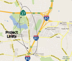 In December 2012, the CTC accepted a draft EIR on
interchange improvements in Vallejo. The project will modify the existing
I-80/Redwood Parkway interchange (~ SOL 4.409) to a tight diamond
configuration, realign Fairgrounds Drive to a tee intersection north of
the I-80 westbound ramps, widen Fairgrounds Drive between Redwood Street
and Route 37, widen the westbound exit ramp from Route 37 to Fairgrounds
Drive, and improve the intersections at the Route 37/Fairgrounds Drive
Interchange. The project is not yet funded; however, the project is
expected to be fully funded with local funds. The total estimated cost for
capital and support is $46,400,000. No alternatives (other than no-build)
were considered due to the density of the area.
In December 2012, the CTC accepted a draft EIR on
interchange improvements in Vallejo. The project will modify the existing
I-80/Redwood Parkway interchange (~ SOL 4.409) to a tight diamond
configuration, realign Fairgrounds Drive to a tee intersection north of
the I-80 westbound ramps, widen Fairgrounds Drive between Redwood Street
and Route 37, widen the westbound exit ramp from Route 37 to Fairgrounds
Drive, and improve the intersections at the Route 37/Fairgrounds Drive
Interchange. The project is not yet funded; however, the project is
expected to be fully funded with local funds. The total estimated cost for
capital and support is $46,400,000. No alternatives (other than no-build)
were considered due to the density of the area.
HOV Lanes: Red Top Road to Air Base Parkway (~ SOL R11.388 to SOL 19.186)
![[Fairfield HOV lanes]](maps/080-fairfield-hov.jpg) In January 2009, the CTC approved for future funding a project to construct High Occupancy Vehicle
(HOV) lanes in both directions between Red Top Road and Air Base Parkway
on Route 80 in Fairfield. The project will construct HOV lanes in both
directions in the existing median along an 8.7 mile section of Route 80 in
Solano County. The project is programmed with CMIA funds, federal
demonstration funds, and Regional Measure 2 funds. The total estimated
project cost is $80,000,000. The project has been split into three
segments. The construction of the final segment (8320C) is estimated to
begin in FY 2009-10. The scope as described for the preferred alternative
is consistent with the project scope set forth in the approved project
baseline agreement.
In January 2009, the CTC approved for future funding a project to construct High Occupancy Vehicle
(HOV) lanes in both directions between Red Top Road and Air Base Parkway
on Route 80 in Fairfield. The project will construct HOV lanes in both
directions in the existing median along an 8.7 mile section of Route 80 in
Solano County. The project is programmed with CMIA funds, federal
demonstration funds, and Regional Measure 2 funds. The total estimated
project cost is $80,000,000. The project has been split into three
segments. The construction of the final segment (8320C) is estimated to
begin in FY 2009-10. The scope as described for the preferred alternative
is consistent with the project scope set forth in the approved project
baseline agreement.
The project was completed in November 2009, adding over eight miles of HOV lanes in both directions and widening the median on I-80 from approximately Red Top Road to Airbase Parkway. The HOV lanes are now open from 5:00 a.m. to 10:00 a.m. and 3:00 p.m. to 7:00 p.m. Monday through Friday for vehicles with 2 or more occupants.
In December 2009, the CTC approved for future consideration of funding a project that will construct ramp metering facilities and roadway improvements at existing interchange entrance and connector ramps of I-80 from Red Top Road to Air Base Parkway in the city of Fairfield. The project is programmed in the Corridor Mobility Improvement Account and includes local funds. Total estimated project cost is $10,026,000, capital and support. This ramp metering project is a child project of the parent I-80 HOV Lanes Project (PPNO 8320B). There was no Notice of Determination filed for this project. Instead, an Addendum to the MND for the parent project was prepared. The scope as described for the preferred alternative is consistent with the project scope set forth in the approved project baseline agreement.
In February 2013, it was reported that Caltrans plans to convert HOV lanes on I-80 into HOT ("Express" or High Occupancy/Toll) lanes -- specifically, I-80 in both directions - from around Air Base Parkway to I-680 in Fairfield and the Carquinez Bridge to the Bay Bridge toll plaza. Express lanes work by continuing to allow carpoolers free access to the fast lane but then selling unused capacity to drivers who wouldn't normally qualify to drive in them. Tolls are collected electronically using FasTrak transponders, and electronic systems are used to monitor traffic and set tolls at a rate designed to keep traffic in the lanes flowing at 50 mph or faster. As the lanes get more congested, tolls rise, and as gridlock eases, they drop. Toll rates for the network have not been set yet, but on the existing lanes they have varied from a 30-cent minimum to about $5 or $6.
Solano I-80 Managed Lanes project: Red Top Road / Air Base Parkway to I-505 (04-Sol-80, PM 10.4/30.2)
The SAFETEA-LU act, enacted in August 2005 as the reauthorization of TEA-21, provided the following expenditures on or near this route:
 In April 2015, it was reported that the Solano
Transportation Authority approved an agreement for preliminary engineering
and final design work on an I-80 express lane project from Red Top Road to
I-505. The project includes the conversion of an existing HOV lane to an
express lane in the west segment from Red Top Road to Air Base Parkway and
new construction of an express lane in the east segment from Air Base
Parkway to I-505. The eastbound HOV lane currently ends at Air Base
Parkway, where motorists encounter a significant bottleneck. The west
segment will be funded with bridge toll funds already allocated; the
authority will need to get an allocation of bridge funds, meanwhile, to
cover the east segment. The project would provide approximately 18 miles
of express lanes along the I-80 corridor through the conversion and
highway widening. Plans call for the west segment of the project to be
complete by the end of 2018 and construction of the east segment to be
done by 2019.
In April 2015, it was reported that the Solano
Transportation Authority approved an agreement for preliminary engineering
and final design work on an I-80 express lane project from Red Top Road to
I-505. The project includes the conversion of an existing HOV lane to an
express lane in the west segment from Red Top Road to Air Base Parkway and
new construction of an express lane in the east segment from Air Base
Parkway to I-505. The eastbound HOV lane currently ends at Air Base
Parkway, where motorists encounter a significant bottleneck. The west
segment will be funded with bridge toll funds already allocated; the
authority will need to get an allocation of bridge funds, meanwhile, to
cover the east segment. The project would provide approximately 18 miles
of express lanes along the I-80 corridor through the conversion and
highway widening. Plans call for the west segment of the project to be
complete by the end of 2018 and construction of the east segment to be
done by 2019.
(Source: Daily Republic, 4/16/2015)
In October 2016, there was a discussion on AAroads
about the project to construct new express/HOT lanes from west of Exit 39A
(Red Top Road) to just east of the I-505 interchange, and including
relocation of the northern end of I-680 at I-80 to connect with the
existing Route 12 interchange (this is actually a separate project; see
above). Phase 1 of this project has already been completed. The express
lane project has 2 components - conversion of the existing HOV lanes in
Fairfield to HOT lanes and a new HOT lane in each direction from Fairfield
to Vacaville. The anticipated construction start date is June 2018. The
HOV lanes currently operate with continuous access - you can enter and
exit from any point - and the HOT lanes will still have that feature, as
will the new lanes. Bay Area planners believe that the continuous access
will make the lanes more attractive to users. There is some risk of
increased violations with this feature but they believe that it may not be
much of a problem.
(Source: Coatamundi and Joe Rouse at AAroads, October 2016)
In October 2019, it was reported that the Solano
Transportation Authority has proposed a project to create new managed
lanes along I-80 in Solano County... and they were on a quest for funds.
STA Executive Director Daryl Halls said he would be asking the two
chambers to lend their support starting in early 2020 and that Fairfield
Mayor Harry Price and Vacaville Mayor Ron Rowlett — who both sit on
the STA Board with Supervisor Jim Spering and the other Solano mayors
— would be leading the charge. The plan for Solano’s initial
construction phase is to build 10 miles of new managed lanes —
highway lanes such as express lanes, toll lanes and high-occupancy vehicle
lanes where operational strategies are put in place and managed in
response to changing conditions — along I-80 between Air Base
Parkway and just east of I-505 as well as converting 8 miles of existing
HOV lanes between Red Top Road and Air Base Parkway in Fairfield to
managed lanes. Future phases would include expanding managed lanes through
Dixon to the Yolo County line and through Vallejo to the Carquinez Bridge
to create continuous managed lanes throughout Solano. The overall project
is expected to cost about $228 million. An STA environmental report was
completed in Dec. 2015 and revalidated in March 2018, and the design was
completed in June of that year. Additionally, the project was submitted by
Caltrans in July for a federal INFRA Congested Corridors grant. Halls said
the next round of opportunity for funding would be as part of a Senate
Bill 1 Congested Corridors and Trade Corridor Enhancement program in 2020.
$75 million for this project has been committed out of money raised
through Regional Measure 3, the initiative approved by voters in 2018 to
increase tolls at Bay Area bridges to fund transportation projects.
However, the measure remains tied up in court, STA will have to match the
money if RM3 funds are not available by spring.
(Source: The Reporter, 10/30/2019)
The 2020 STIP, approved at the CTC March 2020 Meeting,
included new programming for PPNO 0658L Solano 80 Managed Lanes (SB1),
with $34,000K programmed for R/W and CONST in FY21-22.
(Source: March 2020 CTC Agenda, Item 4.7, 2020 STIP
Adopted 3/25/2020)
In June 2020, the CTC noticed a STIP amendment to
reprogram $16,700,000 in Regional Improvement Program (RIP) funds from the
Solano I-80 Managed Lanes project (PPNO 0658L) to the Solano
I-80/I-680/Route 12 Interchange – Package 2A project (PPNO 5301X) in
Solano County (see below). The Solano I-80 Managed Lanes project is
currently programmed in the 2020 STIP with $710,000 RIP for Right of Way
and $33,290,000 RIP for Construction; all funds programmed in 2021-22. The
construction phase of this project is not fully funded at this time. The
STA and the Department are planning to seek SB 1 funds during the upcoming
cycle of SB 1 funding. The STA is committed to fully fund this project
using RM3 funds once the litigation has been resolved. This amendment was
approved at the August 2020 meeting.
(Source: June 2020 CTC Agenda, Agenda Item
2.1b.(1); August 2020 CTC Agenda, Agenda Item 2.1a.(3))
In December 2020, it was reported that the CTC approved
$123 million to complete a $275 million funding package for construction
to begin in 2021 on 18 miles of Express Lanes along I-80 through the heart
of Solano County, providing travelers a reliable trip through this vital
artery connecting the Bay Area to Sacramento. The express lanes will also
support express buses in the corridor and encourage carpooling as an
alternative to single-occupant vehicles.
(Source: The Bay Link, 12/3/2020)
In June 2021, the CTC approved amending the STIP to use
the funding available through the 2021 Mid-Cycle STIP and share
distribution of the federal Coronavirus Response and Relief Supplemental
Appropriations Act of 2021 funds (COVID Relief Funds) to increase funding
for a project already in the STIP as follows: Solano Route 80 Managed
Lanes Project (PPNO 0658L); program $1,859K to the CON capital phase in FY
2021-22.
(Source: June 2021 CTC Agenda, Agenda Item
2.1a.(19))
In August 2021, the CTC approved for future
consideration of funding 04-Sol-80, PM 10.4/30.2. I-80 Express Lanes
Project. Construct express lanes on I-80 in Solano County. (MND)
(PPNO 0658L) (STIP) (TCEP). This project is located on I-80 from post mile
10.4 to 30.2, in the cities of Fairfield and Vacaville. The Department, in
cooperation with the Solano Transportation Authority and the Metropolitan
Transportation Commission, proposes to provide High Occupancy Vehicle/High
Occupancy Toll lanes in the westbound and eastbound direction of I-80. The
project will construct approximately 18 miles of express lanes in the I-80
corridor through conversion of existing HOV lanes and highway widening for
new express lanes. The project is fully funded and is currently programmed
in the 2020 State Transportation Improvement Program (STIP) for a total of
$243,024,000, which includes local funds, Surface Transportation Program
funds, and Trade Corridor Enhancement Program (TCEP) funds. Construction
is estimated to begin in 2021-22. The scope, as described for the
preferred alternative, is consistent with the project scope as programmed
by the Commission in the 2020 STIP. A copy of the MND has been provided to
Commission staff. The project will result in less than significant impacts
to the environment after mitigation. The following resource areas may be
impacted by the project: paleontological, noise, and biological resources.
Avoidance and minimization measures will reduce any potential effects on
the environment. These measures include, but are not limited to,
paleontological monitoring, noise abatement and compensatory mitigation
for impacts to woodland, riparian, owl, and red legged frog habitat. As a
result, an MND was completed for this project.
(Source: August 2021 CTC Agenda, Agenda Item
2.2c.(1))
Also in August 2021, the CTC approved an allocation of
$115,759,000 from the Budget Act of 2020, Budget Act Item 2660-301-3291
for construction and $26,800,000 for construction engineering for Solano
80 Managed Lanes (PPNO 04-0658L; ProjID 0412000332; EA 4G080;
04-Sol-80 10.4/30.2). Through the cities of Fairfield and Vacaville In
Solano County. Construct managed lanes on westbound and eastbound I-80
from west of Red Top Road to east of I-505 in Solano County, California.
This project) would construct approximately 18 miles of managed lanes,
which include high occupancy vehicle (HOV) lanes and express lanes,
through conversion of existing HOV lanes to express lanes and highway
widening for new express lanes. The proposed improvements extend from post
mile (PM) 10.4 to 30.2, through the cities of Fairfield and Vacaville. The
project would also extend the Class I Ulatis Creek Trail under I-80 to
eliminate an existing barrier for pedestrians and bicyclists between the
Vacaville Transportation Center and downtown Vacaville, an MTC Priority
Development Area. (Concurrent Future Consideration of Funding under
Resolution E-21-75.) (Contribution from other sources: $0 (CON ENG) and
$63,465,00 (CONST) in local Federal funds.)
(Source: August 2021 CTC Agenda, Agenda Item
2.5s.(5) / 2.5v.(3))
In May 2022, it was reported that a ceremony was held
to break ground on the $244 million Interstate 80 Express Lanes
construction project. The projects will deliver 18 miles of uninterrupted
express lanes in both directions on I-80 between Fairfield and Vacaville
in Solano County. The lanes will be open to motorists with three or more
occupants, buses and motorcycles, and those motorists willing to pay a
toll fee. Unlike carpool lanes, however, express lanes can be managed so
the occupancy requirements and hours of operation can be changed according
to circumstances. The project involves two components. The first is
building 10 miles of new express lanes in the median of I-80 between Air
Base Parkway in Fairfield and Leisure Town Road in Vacaville, just east of
the I-505 interchange. Later, workers will convert 8 miles of
bi-directional carpool lanes into express lanes between Red Top Road and
Air Base Parkway in Fairfield. The project is expected to take three years
to complete.
(Source: Solano Daily Republic, 5/15/2022)
In February 2023, there was an update on this project.
The vision is that by 2024, the addition of these managed lanes will
incentivize drivers to carpool or choose public transit to bypass the
clogged lanes. The 18-mile stretch of roadway is split into two projects:
converting 8 miles of existing carpool lanes into managed lanes between
Cordelia and Air Base Parkway in Fairfield and constructing 10 miles of
new managed lanes between Air Base Parkway in Fairfield and Leisure Town
Road in Vacaville near the I-80/I-505 interchange. The $228 million
construction project broke ground in 2022 and is on course to finish on
time.
(Source: SF Gate, 2/16/2023)
Cordelia Area Integrated Corridor Management (SOL 11.4 to SOL 20.1)
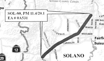 In 2007, the CTC considered a number of requests for funding from the Corridor Mobility Improvement Account
(CMIA). Two requests were funded: Integrated fwy/local road management
near the Carquinez-Bay Bridge ($55.3M) and construction of HOV lanes from
Fairfield (Route 80/I-680/Route 12 to Putah Creek) ($56.21M). In February
2008, the latter project was divided into three phases:
In 2007, the CTC considered a number of requests for funding from the Corridor Mobility Improvement Account
(CMIA). Two requests were funded: Integrated fwy/local road management
near the Carquinez-Bay Bridge ($55.3M) and construction of HOV lanes from
Fairfield (Route 80/I-680/Route 12 to Putah Creek) ($56.21M). In February
2008, the latter project was divided into three phases:
Route 80/I-680/Route 12 Interchange (~ SOL R11.4 to SOL 16.575)
The SAFETEA-LU act, enacted in August 2005 as the reauthorization of TEA-21, provided the following expenditures on or near this route:
A request to reconstruct the Route 80/I-680/Route 12 interchange ($93.79M) was not recommended for funding. In the Sacramento area and points east, Phase 3A of the WB HOV and auxiliary lanes from Eureka to Route 65 ($31.3M) were recommended for funding. Not recommended for funding were HOV lanes from the Sacramento River to Longview Dr ($100M) and the Yolo bypass bicycle bridge ($25.3M). In July 2007, the CTC amended the program to fund the Placer Route 80 HOV and Aux lanes project.
The California Transportion Commission, in September 2000, considered a Traffic Congestion Relief Program proposal to reconstruct the I-80/I-680/Route 12 interchange; it would be a 12-interchange complex constructed in seven stages. The proposal was $1 million for stage 1; the total estimated cost was $13 million. This is TCRP Project #25, requested by the Solano Transportation Authority.
In his 2006 Strategic Growth Plan, Governor Schwartzenegger proposed constructing the I-80/I-680/Route 12 Interchange Complex, including HOV Connector Lanes. He also proposed constructing HOV lanes in Sacramento County.
In September 2010, the CTC approved for future consideration of funding a project in Solano County that will rebuild and relocate the eastbound truck scales facility, build a four lane bridge across Suisun Creek, and construct braided ramps from the new truck scales facility to eastbound I-80 and eastbound Route 12 ramps. The project is programmed in the Trade Corridors Improvement Fund and the Traffic Congestion Relief Program and includes local funds. Construction is estimated to begin in Fiscal Year 2011-12. Total estimated project cost is $100,900,000 for capital and support. The scope as described for the preferred alternative is consistent with the project scope set forth in the proposed project baseline agreement. Resources that may be impacted by the project include; water quality, paleontology, cultural resources, visual resources hazardous waste, air quality, and noise. Potential impacts associated with the project can all be mitigated to below significance through proposed mitigation measures. Because of the sensitivity of the resources in the project area, a Final Environmental Impact Report was prepared for the project.
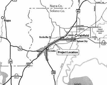 In January 2013, the CTC approved for future consideration of funding a project in Solano
County that will improve the I-80/I-680/Route 12 Interchange, including
the relocation of the westbound truck scales facility on I-80. For the
preferred full-build alternative, the current total estimated cost for
capital and support is $1,348,400,000. The project is not fully funded and
will be developed in phases. Only Phase One of the full-build alternative
is included in the financially constrained Regional Transportation Plan
(RTP). Within Phase One, the first construction contract's total estimated
cost for capital and support is $100,400,000, which is funded by the 2012
State Transportation Improvement Program (STIP), the Trade Corridor
Improvement Funds (TCIF) and local funding. The scope of the first
construction contract includes the reconstruction of the I-80/Green Valley
Interchange and construction of a two lane westbound I-80 to westbound
Route 12 Connector with a new bridge over the I-80 Green Valley Road
onramp. Construction is estimated to begin in fiscal year 2013-2014. The
scope of the preferred alternative is consistent with the scope of the
first construction contract that is programmed in the 2012 STIP and the
TCIF.
In January 2013, the CTC approved for future consideration of funding a project in Solano
County that will improve the I-80/I-680/Route 12 Interchange, including
the relocation of the westbound truck scales facility on I-80. For the
preferred full-build alternative, the current total estimated cost for
capital and support is $1,348,400,000. The project is not fully funded and
will be developed in phases. Only Phase One of the full-build alternative
is included in the financially constrained Regional Transportation Plan
(RTP). Within Phase One, the first construction contract's total estimated
cost for capital and support is $100,400,000, which is funded by the 2012
State Transportation Improvement Program (STIP), the Trade Corridor
Improvement Funds (TCIF) and local funding. The scope of the first
construction contract includes the reconstruction of the I-80/Green Valley
Interchange and construction of a two lane westbound I-80 to westbound
Route 12 Connector with a new bridge over the I-80 Green Valley Road
onramp. Construction is estimated to begin in fiscal year 2013-2014. The
scope of the preferred alternative is consistent with the scope of the
first construction contract that is programmed in the 2012 STIP and the
TCIF.
In March 2013, it was reported that the I-80/I-680 interchange project could be impacted by new Buy America regulations. The $700 million project involves an overall reconstruction of the I-80/680 and Route 12 interchange in Fairfield. Planned in seven segments, the work includes replacing the Green Valley Road interchange and placing new interchanges at Jameson Canyon and Red Top roads. Enacted last October, the new Buy America amendments require public agencies to buy domestically made products for all infrastructure work or else lose governmental funding. Previously, the act applied only to project portions receiving federal funding. In addition, the buying requirements now apply to public utility agreements needed when electric and gas lines must be moved -- a major portion of the upcoming interchange work in Fairfield. A major hurdle is figuring out how to amend utility agreements the agency signed with Pacific Gas & Electric before the new Buy America regulations.
In May 2013, it was reported that the funding outlook for the updated I-80/I-680/Route 12 interchange was improving. The required permit from the U.S. Army Corps of Engineers was obtained, and the Solano Transportation Authority had done what it is supposed to do to get the project ready for construction. The project is designed to improve traffic flow near the I-80 / I-680 interchange. It involves renovating the nearby Green Valley interchange and building ramps to sort traffic entering westbound I-80 from the Green Valley interchange from traffic exiting I-80 for Route 12 in Jameson Canyon. Construction work is to cost $60 million. The $24 million at risk is to come from Proposition 1B, the transportation bond passed by voters in 2006. The potential obstacle stems from the Buy America provisions, which requires that projects that receive federal dollars be built with materials made in America. Revisions in the 2012 federal transportation bill extend these provisions to contracts, including utility agreements, associated with the projects.
In June 2013, the CTC approved amending the baseline agreement for TCIF Project 89 (WB I-80 to Route 12 [West] Connector and Green Valley Road Interchange Improvements project (PPNO 5301L) in Solano County to revise the project funding plan and delivery schedule. This project will construct a two-lane WB I-80 to WB Route 12 Connector that will cross over the new WB I-80/Green Valley Road on-ramp. The project will also reconstruct the I-80/Green Valley interchange.
In April 2014, it was reported that significant
overhead work was recently completed on the I-80/I-680/Route 12
interchange project, marking a major milestone in the first phase of
construction. In particular, preliminary overhead structures were
installed earlier this month for the new Green Valley Road overcrossing
over I-80. Ground was broken for the first phase of the project in June
2014. About 75% of the work should be complete by the end of the year, a
Caltrans engineer estimated in March. The first phase should be complete
by December 2016 or a little sooner depending on the weather, he said.
(Source: Daily Republic, 4/23/2015)
In September 2014, construction started on the I-80/I-680 project. This initial project doesn’t include direct work on the I-80 and I-680 interchange structure itself, but rather replaces the nearby Green Valley interchange. Workers over the next one-and-a-half years will build a new Green Valley interchange slightly to the east of the existing one. This new interchange will have a four-lane overpass as opposed to two lanes. Workers will also build new onramps to better sort out traffic merging from Green Valley Road onto westbound I-80 and I-80 traffic exiting onto westbound Route 12 at Jameson Canyon. The connector ramp from westbound I-80 to Route 12 also will be widened from one lane to two lanes. This first round of improvements will cost about $65 million and could be completed by summer 2016. The project received $15 million from Proposition 1B, a 2006 voter-approved transportation bond. The remaining six phases will be constructed and completed as funding becomes available. Improvements in the upcoming phases will include: (1) New interchange at Red Top Road and I-680; (2) New westbound connector ramp from westbound I-80 to southbound I-680; (3) Realignment of I-680 between I-80 and the Lopes Road exit in Cordelia; (4) Realignment of the connector ramp from Route 12 to eastbound I-80; (5) New entrance/exit ramps; and (6) The extension of some local streets leading to I-80 and Route 12.
In October 2015, the CTC again approved for future consideration of funding a project that will improve the I-80/I-680/Route 12 Interchange, including relocation of the westbound truck scales facility on I-80. For the preferred fullbuild alternative, the current total estimated cost for capital and support is $2,166,000,000. The project is not fully funded and will be developed in phases. Only Phase One of the full-build alternative is included in the financially constrained Regional Transportation Plan. Within Phase One, the first construction contract’s total estimated cost for capital and support is $100,400,000, which is funded by the 2012 State Transportation Improvement Program, the Trade Corridor Improvement Fund and local funding. Contract 1 of Phase One is currently under construction. The design phase of Contract 2 of Phase One is 35% complete. The scope of the first construction contract includes the reconstruction of the Interstate 80/Green Valley Interchange and construction of a two-lane westbound I-80 to westbound Route 12 Connector with a new bridge over the I-80 Green Valley Road onramp. The scope of the preferred alternative is consistent with the scope of the first construction contract that is programmed in the 2012 State Transportation Improvement Program and the Trade Corridor Improvement Fund. It was received again because an Addendum had been completed due to changes in the project since Commission approval of the Final Environmental Impacts Report (FEIR) in 2013.
In August 2016, it was reported that a new ramp in
Fairfield connecting WB I-80 and WB Route 12 will be opening at the end of
August, according to the California Department of Transportation. As part
of the project, the new westbound I-80 onramp from Green Valley Road will
also be opened. Caltrans will begin shifting westbound I-80 traffic to the
new ramp, which along with the new Green Valley Road overcrossing
completes the first of seven phases of the I-80/I-680/Route 12 Interchange
Project. This first phase cost about $67 million, according to Caltrans.
Some $15 million came from Proposition 1B, a transportation bond approved
by California voters in 2006. Upcoming phases will include a new
interchange at Red Top Road and I-680, a new westbound connector ramp from
westbound I-80 to southbound I-680, a realignment of I-680 between I-80
and the Lopes Road exit, a realignment of the connector ramp from Route 12
to eastbound I-80, new entrance and exit ramps and the extension of some
local streets leading to I-80 and Route 12. These next segments are still
in need of funding, according to Caltrans.
(Source: The Reporter, 8/9/2016)
The 2018 STIP, approved at the CTC March 2018 meeting, appears to have allocated $9M in FY19-20 for PS&E for PPNO 5301X I-80/I-680/Route 12 Interchange - Package 2A
In May 2018, it was reported that the California
Transportation Commission approved $53 million for a project designed to
help eliminate the Route 12/Jameson Canyon bottleneck at I-80.
Construction to create a two-lane ramp from eastbound Route 12 to
eastbound I-80 could begin in 2020, Solano Transportation Authority
Executive Director Daryl Halls said. He estimated the project will cost
about $70 million, with the remaining money coming from other sources.
Caltrans in 2014 finished widening Route 12 from two to four lanes along
the six-mile Jameson Canyon segment. But the two eastbound lanes squeeze
down to one lane at the interchange ramp, causing backups that commuters
say can top a mile.
(Source: Napa Valley Register, 5/17/2018)
The 2020 STIP, approved at the March 2020 CTC meeting,
made no changes to the programming for PPNO 5301X Rt 80/680/12 Interchange
- Package 2A (18S-03) and PPNO 5301L Rt 80/680/12 Interchange (2nd
Supplemental); they are at $9,000K and $798K in prior years respectively.
It did modify PPNO 5301V Jepson Pkwy, 4-lane widen, Elmira Rd-New Ulatis
Crk, taking the funds programmed for FY20-21 and moving them to FY21-22.
(Source: March 2020 CTC Agenda, Item 4.7, 2020 STIP
Adopted 3/25/2020)
In June 2020, the CTC noticed a STIP amendment to
reprogram $16,700,000 in Regional Improvement Program (RIP) funds from the
Solano I-80 Managed Lanes project (PPNO 0658L) to the Solano
I-80/I-680/Route 12 Interchange – Package 2A project (PPNO 5301X) in
Solano County. The I-80/I-680/Route 12 project will replace the existing
single-lane eastbound Route 12 to eastbound I-80 connector structure with
a new two-lane structure that meets the operational requirements for the
ultimate configuration of this interchange. The project will also
construct direct ramps to Green Valley Road that will improve safety by
eliminating the existing weaving conflicts. The construction funding plan
for the project consists of Senate Bill (SB) 1 - Trade Corridor
Enhancement Program (TCEP) and Regional Measure (RM) 2 funds, and
construction is currently programmed in Fiscal Year 2019-20. The project
is being delivered using the Construction Manager/General Contractor
(CMGC) method of delivery. However, based upon the latest cost estimate,
the construction capital cost has been revised from $50,300,000 to
$67,000,000; which is an increase of $16,700,000. This increase is due to
the following reasons: (1) Geotechnical (Earthwork and structural
section): $8 Million — After the constructability review was
conducted, an extensive redesign was needed that resulted in significant
changes in quantities and upward revisions to unit prices. These
designchanges have increased the cost of the structural section by
$6,000,000. An additional $2,000,000 increase has resulted from more
extensive soil stabilization requiring longer piles and wick drains to
consolidate the unforeseen expansive and unstable soils at the abutment
locations. (2) Drainage: $4.2 Million — Based upon the final
design, new drainage system components are needed to better drain the flat
gradients surrounding the new roadway and to avoid conflicts with the
existing drainage systems. This includes two drainage crossings under the
I-80 that require an open trench on the west end and micro-tunneling at
the east end. (3) Traffic staging: $1.0 Million — The
original design details did not fully anticipate detour complexity and
resulting traffic staging challenges which require more extensive
construction signing/striping and traffic handling measures. The revised
estimate for temporary and permanent striping and staging requirements has
resulted in a cost increase of $1.0 million. (4) Specialty items: $3.5
Million — To address the revised trash capture requirements
from the Regional Water Quality Control Board, a large bioswale will be
constructed adjacent to the Green Valley Road off-ramp. Additional erosion
control measures are also needed to stabilize the embankments and cut
sections. Finally, the cost of median barrier has gone up as a result of
revised quantities and increase in unit prices. The amendment was approved
at the August 2020 meeting.
(Source: June 2020 CTC Agenda, Agenda Item
2.1b.(1); August 2020 CTC Agenda, Agenda Item 2.1a.(3))
The STA has been working with the Metropolitan
Transportation Commission to secure Regional Measure (RM) 3 funds to cover
the cost increase. However, because of still-unresolved litigation of RM3
funds, those funds are not available at this time. Therefore, the STA is
proposing to cover this funding shortfall by re-programming $16,700,000
RIP funds from the Solano I-80 Managed Lanes project (PPNO 0658L). The
Solano I-80 Managed Lanes project is currently programmed in the 2020 STIP
with $710,000 RIP for Right of Way and $33,290,000 RIP for Construction;
all funds programmed in 2021-22. The construction phase of this project is
not fully funded at this time. The STA and the Department are planning to
seek SB 1 funds during the upcoming cycle of SB 1 funding. The STA is
committed to fully fund
this project using RM3 funds once the litigation has been resolved. There
are also minor changes in the project limits, with the new limits being
04-Sol-80 11.4/12.8.
(Source: June 2020 CTC Agenda, Agenda Item
2.1b.(1))
In August 2020, the California Transportation
Commission (CTC) approved the allocation of $69,900,000 of funds for the
second phase of the I-80/I-680/Route 12 Interchange Project. The next
phase in the seven-phase project seeks to replace the existing single-lane
eastbound Route 12 connector to eastbound I-80 with a new two-lane
connector, in addition to constructing direct on and offramps from I-80 to
Green Valley Road in Fairfield. The project was financed through funds
from Senate Bill 1’s Trade Corridor Enhancement Program, State
Transportation Improvement Program as well as regional bridge toll funds.
It is expected to begin construction in September with the overall work
estimated to last two years.
(Source: August 2020 CTC Agenda, Agenda Item
2.5s.(5); The Reporter, 8/13/2020)
In October 2020, it was reported that construction has
begun on the estimated $77 million interchange project where I-80, I-680,
and Route 12 converge in Fairfield, a two-year effort that is expected to
improve traffic flow by configuring ramps and access to local streets.
Funded largely by Senate Bill 1, the project will replace the existing
single-lane eastbound Route 12 connector to eastbound I-80, a well-known
commuter bottleneck, with a new two-lane connector on a new alignment and
bridge structure that meets design requirements for the project’s
remaining phases. Additionally, the project will include the building of a
new slip ramp from eastbound Route 12 to Green Valley Road and a new
“braided” off-ramp from eastbound I-80.
(Source: Times Herald Online, 10/29/2020)
 In May 2021, it was reported that construction was in progress on the Route 12 / I-80
connector. While Route 12 through Jameson Canyon is two lanes in each
direction, that drops to one eastbound lane just before the freeway. A
one-lane connector ramp between highway and freeway is the culprit and a
two-lane ramp is the planned solution. Construction is currently replacing
that one-lane connector ramp bridge that curves over I-80. The new bridge
is expected to open in fall 2021, and the old bridge will be demolished.
Also in the works is a component sorting out the traffic streams heading
to eastbound I-80, Green Valley Road, and southbound I-680. They presently
crisscross as drivers jockey for position. So the plan is to have the
connector ramp split after crossing the freeway, with I-80-bound traffic
going one route and Green Valley Road-bound going another. Meanwhile,
still another route will carry eastbound I-80 traffic bound for Green
Valley Road and southbound I-680. Separating these traffic streams will
mean building a second, smaller bridge.
In May 2021, it was reported that construction was in progress on the Route 12 / I-80
connector. While Route 12 through Jameson Canyon is two lanes in each
direction, that drops to one eastbound lane just before the freeway. A
one-lane connector ramp between highway and freeway is the culprit and a
two-lane ramp is the planned solution. Construction is currently replacing
that one-lane connector ramp bridge that curves over I-80. The new bridge
is expected to open in fall 2021, and the old bridge will be demolished.
Also in the works is a component sorting out the traffic streams heading
to eastbound I-80, Green Valley Road, and southbound I-680. They presently
crisscross as drivers jockey for position. So the plan is to have the
connector ramp split after crossing the freeway, with I-80-bound traffic
going one route and Green Valley Road-bound going another. Meanwhile,
still another route will carry eastbound I-80 traffic bound for Green
Valley Road and southbound I-680. Separating these traffic streams will
mean building a second, smaller bridge.
(Source: $ Napa Valley Register, 5/6/2021)
Lastly, a change is coming to Red Top Road. This
currently ends in a T-intersection at Route 12 just before the connector
ramp. Vehicles turning left or right from Red Top Road onto the highway
must squeeze amid the traffic stream. As of 5/10/2021, Caltrans will close
the Red Top Road entrance onto Route 12 for safety reasons. Motorists will
be allowed to make a right turn from eastbound Route 12 onto Red Top Road.
However, the left-turn movement from northbound Red Top Road to westbound
Route 12 toward Napa County will be eliminated. Motorists are advised to
take eastbound I-80 to the Green Valley Road exit, cross over the freeway
and take the onramp to westbound I-80/westbound Route 12 toward Napa. When
all is done, eastbound Route 12 vehicles still might not always flow onto
I-80 without a stop. If I-80 has heavy traffic, a metering light will be
triggered along the connector ramp, similar to the one that is there
today.
(Source: $ Napa Valley Register, 5/6/2021; Patch.Com, 5/6/2021)
In August 2022, it was reported that the latest piece
of the massive I-80 / I-680 / Route 12 Interchange Project was completed
Monday with the opening of the eastbound I-80 to southbound I-680
connector ramp. State Department of Transportation crews re-opened the new
connector ramp to the traveling public. Motorists traveling eastbound on
Route 12 now have direct access to the southbound I-680 connector ramp,
including drivers who are traveling eastbound on I-80, Caltrans reported.
(Source: Solano Daily Republic, 8/3/2022)
In October 2022, it was reported that officials have
marked the completion of the latest portion of a massive project to revamp
the convergence in Fairfield of I-80, I-680 and Route 12: Completion of
the connector from EB Route 12 to EB I-80. The I-80/I-680/Route 12 project
is a multiple-year, multiple-phase effort near Fairfield’s Green
Valley and Cordelia Villages neighborhoods that includes Package 1 through
Package 7. Package 1 was completed in 2017 with a new Green Valley Road
Interchange and westbound Route 12 connector from westbound I-80 to
westbound Route 12 The just-completed phase of the project, known as
Package 2A, will improve the flow of traffic through the reconfiguration
of three freeway ramps at the interchange. It replaces the existing
single-lane eastbound Route 12 to eastbound I-80 connector with a new
two-lane connector and bridge structure, constructs a new off-ramp from
eastbound Route 12 to Green Valley Road, and creates a new off-ramp from
eastbound I-80 to Green Valley Road and southbound I-680.
(Source: Solano Daily Republic, 10/22/2022)
In July 2023, it was reported that in June 2023 MTC
last month formally approved the first allocations of Regional Measure 3
dollars, releasing over $270 million for nine projects for which the
sponsors already were moving ahead under Letters of No Prejudice. These
initial allocations included: Solano Transportation Authority: $70.4
million for work on the I-80 Express Lanes project between Cordelia and
Vacaville; $1.9 million to advance Phase II of the I-80/ I-680/Route 12
interchange reconfiguration; and $30.7 million for replacement and
relocation of the westbound I-80 truck scales.
(Source: MTG/ABAG Bay Link Blog, 7/12/2023)
In March 2016, the CTC allocated additional funding for a project located on I-80 from the I-80/Route 12 Separation to 0.7 mile east of Route 12 in the city of Fairfield in Solano County. The project will construct a two-lane west bound I-80 to westbound Route 12 connector and reconstruct the I-80/Green Valley Road interchange (~ SOL 12.776).
Westbound I-80 Cordelia Commercial Vehicle Enforcement Facility (04-Sol-80 14.8/16.5)
In June 2021, the CTC allocated $24,002,000 for the
State-Administered TCEP Westbound I-80 Cordelia Commercial Vehicle
Enforcement Facility project, on the State Highway System (04-Sol-80
14.8/16.5), in Solano County. (PPNO 8273C; ProjID 0421000155; EA 0A53T).
I-80 Near the city of Fairfield. The proposed project will replace the
existing Westbound (WB) I-80 Cordelia Commercial Vehicle Enforcement
Facility (CCVEF). The new facility will be relocated 0.7 mile east from
its current location and will provide a new braided off-ramp connection
and new entrance ramp connection to/from Westbound I-80. Direct access to
the facility will also be provided from westbound Route 12 . The new
facility will have the capacity to inspect all westbound I-80 trucks
passing the facility 24 hours per day, seven days a week. (Future
consideration of funding approved under Resolution E-15-61; October 2015.)
(Source: June 2021 CTC Agenda, Agenda Item
2.5s.(5))
In May 2022, the CTC approved an advance programming
request from the Solano Transportation Authority of $64,800,000 for the
construction of the Westbound I-80 Cordelia Commercial Vehicle Enforcement
Facility. The Westbound I-80 Cordelia Commercial Vehicle Enforcement
Facility Project received a ranking of medium-high. The design phase of
this project was funded in the 2020 Trade Corridor Enhancement Program.
Originally constructed in 1958, the purpose of the Westbound I-80 Cordelia
Commercial Vehicle Enforcement Facility is to enhance public safety
through inspections, operator evaluations, and weight enforcement. The
current facility is extremely undersized, it cannot accommodate the peak
volume of 300 trucks per hour which occurs several times per week. Traffic
regularly fills the available queue, then starts to back-up onto the
freeway, requiring the facility to close. When the facility closes, it
does not allow the California Highway Patrol to inspect these vehicles.
The limited capacity of the current facility also increases the amount of
time it takes for a truck to be processed. The new facility will
significantly increase the capacity for truck inspections, accommodating
up to 1,000 trucks an hour, which is anticipated to help the California
Highway Patrol with enforcement. It will also improve traffic safety along
this section of the highway by reducing conflict and congestion points
near the on- and off-ramps of the facility. In addition, the project will
facilitate zero- emission freight fueling by including heavy-duty vehicle
electric charging stations at the Eastbound and Westbound facilities.
(Source: May 2022 CTC Agenda, Agenda Item 4.14)
In July 2019, it was reported that the High Occupancy Vehicle lane on
westbound Interstate 80 will temporarily end at the Abernathy Road on-ramp
(~ SOL 16.099). Caltrans crews are replacing concrete slab on the Dan
Wilson Creek Bridge near the westbound I-80 Cordelia Truck Scales. The
work, expected to continue to October 2019, will reduce the number of
lanes from six to five, Caltrans announced.
(Source: Daily Republic, 7/2/2019)
In March 2013, there was a report on plans to turn on ramp metering lights in Fairfield and Vacaville (~ SOL 17.213 to SOL R27.985). In 2011, Caltrans spent $4.9 million to install ramp metering lights in Fairfield. It is also installing ramp metering lights along I-80 in Vacaville and north Vallejo. The question is when these lights will get turned on. California Department of Transportation policy calls for the agency to first reach agreements with local cities on how to operate the lights. Agreements can address such issues as under what traffic conditions the lights are used. The current debate is whether this should be per-city or countywide. Caltrans favors having countywide agreements. This simplifies the job for Caltrans. Cities prefer local agreements. Communities have to deal with potential impacts such as backups onto local streets from the ramps and would have ideas on how to mitigate the situation. Caltrans hopes to activate the I-80 ramp meters in Fairfield in 2013 and the ones in Vacaville and north Vallejo in 2014. In Vacaville, the westbound Merchant Street on-ramp, by Caltrans standards, has too much traffic for a ramp meter unless another lane is added.
In January 2015, the CTC authorized relinquishment of right of way in the city of Fairfield on Manuel Campos Parkway (~ SOL 20.922), consisting of collateral facilities.
In September 2003, the CTC considered relinquishment of right of way in the City of Vacaville (City), at Bella Vista Road, consisting of frontage road (~ SOL R25.753).
In June 2008, the CTC approved relinquishment of right of way in the city of Vacaville, on the southeast side of East Monte Vista Avenue, between Browns Valley Parkway and the west bound State Route 80 off ramp, consisting of collateral facilities (~ SOL R27.373).
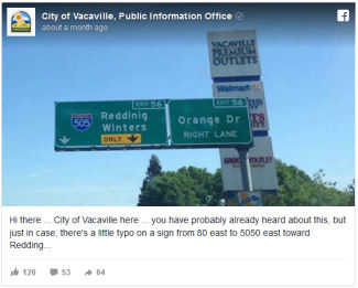 In April 2015, there was a typo on a sign in Vacaville (~
SOL R27.774): Redding was spelled as “Reddinig.” The City of
Vacaville posted a little note on Caltrans District 4’s Facebook
page alerting them of the situation. The sign was corrected quickly.
Post-fix pictures made it appear that Caltrans only covered up the extra
“i,” leaving “Redding” looking a little
disjointed.
In April 2015, there was a typo on a sign in Vacaville (~
SOL R27.774): Redding was spelled as “Reddinig.” The City of
Vacaville posted a little note on Caltrans District 4’s Facebook
page alerting them of the situation. The sign was corrected quickly.
Post-fix pictures made it appear that Caltrans only covered up the extra
“i,” leaving “Redding” looking a little
disjointed.
(Source: CBS Sacramento, 4/20/2016)
Near I-80 in Vacaville (at the Weber Road interchange (~ SOL 31.307) is the former Vaca Valley Raceway, which is currently abandoned as the SF chapter of the Sports Car Club of America cannot afford to refurbish it (although they may do so someday). It existed in the early 1970s near the now-abandoned Vaca-Dixon Airport.
In August 2016, the CTC approved $11,828,000 for Solano 04-Sol-80 31.4/32.6 I-80 near Vacaville, at Meridian Road Overcrossing No. 23-0147 and Midway Road Overcrossing No. 23-0148. Outcome/Output: Seismic retrofit for Meridian Road Overcrossing and replacement of the Midway Road Overcrossing to improve structure resistance to earthquakes and minimize the potential for collapse. Retrofit work will include polyester overlay, reconstruct barrier rail, construct approach slabs, improve existing drainage system and reconstruct deck overhang. Replacement work will include demolishing existing bridge.
Yolo Route 80 Managed Lanes Project (~ 04-SOL-80 40.791 to 03-YOL-80 9.506, 03-YOL-50 0.00 to 03-SAC-50 L0.118)
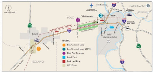 In December 2017, it was reported that Caltrans is hoping to ease congestion on the stretch of
highway on I-80 between Sacramento and Dixon by adding 21 miles of bus and
carpool lanes on both the east and west bound sides of the freeway. The
proposal – which would expand a portion of I-80 from 3 to 4 lanes on
both sides – would extend from Kidwell Road near Dixon all the way
to the corridor where I-80 meets I-5 and US 50. It would also expand the
bike path through the Yolo Bypass. Caltrans says their projections show
the additional carpool lanes could decrease traffic delays by as much as
38% during the evening traffic rush and by 53% in the morning. The
proposal is estimated to cost between $500-$750 million, and Caltrans
hopes more, if not all, of it would be covered by revenue from
California’s new gas tax. If it gets approved, construction is
expected to begin in the summer of 2021.
In December 2017, it was reported that Caltrans is hoping to ease congestion on the stretch of
highway on I-80 between Sacramento and Dixon by adding 21 miles of bus and
carpool lanes on both the east and west bound sides of the freeway. The
proposal – which would expand a portion of I-80 from 3 to 4 lanes on
both sides – would extend from Kidwell Road near Dixon all the way
to the corridor where I-80 meets I-5 and US 50. It would also expand the
bike path through the Yolo Bypass. Caltrans says their projections show
the additional carpool lanes could decrease traffic delays by as much as
38% during the evening traffic rush and by 53% in the morning. The
proposal is estimated to cost between $500-$750 million, and Caltrans
hopes more, if not all, of it would be covered by revenue from
California’s new gas tax. If it gets approved, construction is
expected to begin in the summer of 2021.
(Source: KXTV ABC 10, 12/6/2017)
In May 2018, it was reported that Caltrans has started
to hold public meetings regarding a 16-mile widening of I-80 through Yolo
and Solano counties. The initial idea, Caltrans says, is to build a
carpool lane, also known as a high occupancy vehicle or diamond lane, east
of Dixon to the Sacramento County line in West Sacramento. That would
widen the freeway in key bottleneck spots that occur where I-80 merges
down to three lanes. While the problem affects weekday commuters, some of
the worst slowdowns occur when Bay Area and Sacramento residents alike
cram onto I-80 for weekend getaways. The most challenging section would be
the Yolo Causeway, the 3-mile elevated bridge and berm that crosses the
Yolo floodplain between Davis and West Sacramento. A fourth lane in each
direction would extend to the Sacramento River on I-80 at the Bryte Bend
Bridge and on US 50 at the Pioneer Memorial Bridge, which carries commuter
traffic into downtown Sacramento. The project could cost $400 million.
Caltrans plans to apply for state and federal grants to cover the cost.
Project officials said, they would consider charging a toll for peak-hour
users if the state can't fund the project other ways — and if an
economic analysis shows a toll lane makes sense. The state tentatively
plans to begin construction of the I-80 Yolo/Solano widening project in
2024. The project will include improvements to the causeway bike and
pedestrian path.
(Source: Sacramento Bee, 6/4/2018)
In November 2019, it was reported that Caltrans is
moving ahead with plans to ease traffic congestion plaguing I-80 from
Solano County through Natomas in north Sacramento. Besides making roadway
improvements, it hopes to add a commuter lane in each direction on the
Yolo Causeway, which is the source of slowdowns during commute hours and
on weekends. It will present several ideas for public input at an I-80
improvement open house scheduled in November 2019. Among the solutions
could be a toll lane or a two-way lane that would be switched according to
the volume of vehicles going in one direction or the other. A bicycle or
pedestrian add-on in the causeway is also possible because it would be
cheaper than widening the causeway for vehicle traffic. The solutions
could range from $100 million to $600 million. Additional public meetings
are likely to be held in West Sacramento and Sacramento at later dates.
Construction on the improvements is scheduled to begin in the summer of
2024.
(Source: Fox 40 News, 11/15/2019)
 In February 2020, it was reported that Caltrans was
holding community meetings on the Yolo/I-80 Corridor Improvement project.
The Yolo/I-80 Corridor project proposes improvements to I-80 from Kidwell
Road west of Davis to West El Camino Avenue, including US 50 to the I-5
interchange in Sacramento. Some of the options under consideration include
adding additional lanes to the freeway between the Yolo-Solano County line
and the Yolo Causeway, as well as adding lanes to the causeway itself and
building a separated bicycle/pedestrian crossing over the bypass.
In February 2020, it was reported that Caltrans was
holding community meetings on the Yolo/I-80 Corridor Improvement project.
The Yolo/I-80 Corridor project proposes improvements to I-80 from Kidwell
Road west of Davis to West El Camino Avenue, including US 50 to the I-5
interchange in Sacramento. Some of the options under consideration include
adding additional lanes to the freeway between the Yolo-Solano County line
and the Yolo Causeway, as well as adding lanes to the causeway itself and
building a separated bicycle/pedestrian crossing over the bypass.
(Source: Davis Enterprise, 2/19/2020)
In June 2021, the CTC approved amending the STIP to use
the funding available through the 2021 Mid-Cycle STIP and share
distribution of the federal Coronavirus Response and Relief Supplemental
Appropriations Act of 2021 funds (COVID Relief Funds) to add a new project
to the STIP: Yolo Route 80 Managed Lanes Project (PPNO 8922); program
$4,000K to the PA&ED phase in FY 2021-22.
(Source: June 2021 CTC Agenda, Agenda Item
2.1a.(19))
In July 2021, it was reported that the Federal Highway
Administration (FHWA) awarded the Yolo County Transportation District
$85.9 million in grant funding to improve traffic flow in the I-80
corridor on the west side of the Sacramento-Yolo metro area. Project
elements include: implementing approximately 17 miles of managed lanes
(i.e., Express or Toll lanes) from the Yolo/Solano County line through
Yolo County to West El Camino Avenue on I-80 and to I-5 on US-50 in
Sacramento County; the construction of new lanes on some segments and
restriping to add lanes or using existing lanes for approximately 2.7
miles of the project; adding ITS elements along I-80 and US-50, including
fiber optics, detection, changeable message signs, and ramp meters;
improvements to the Yolo Causeway cycling and pedestrian facility through
reduced curve radii and additional crosswalk, sidewalk lighting, and
safety elements. The project will also include two auxiliary lanes and
will add ramp meters at seven locations.
(Source: FHWA Grant Award, July 2021)
In August 2021, virtual open houses were held for this
project. The project information page notes that the proposal is to
construct improvements consisting of managed lanes, pedestrian/bicycle
facilities, and Intelligent Transportation System (ITS) elements along
I-80 and US-50 from Kidwell Road near the eastern Solano County boundary
(near Dixon), through Yolo County, and to West El Camino Avenue on I-80
and I-5 on US-50 in Sacramento County. The project proposes to add managed
lanes on I-80 and US 50 by a combination of lane conversion, restriping,
shoulder and median reconstruction with a concrete barrier. Drainage
modifications would be required due to median reconstruction in the
locations to which sheet flow currently drains. Existing Intelligent
Transportation System, (ITS) elements and infrastructure would be expanded
and modified and would include ramp meters, fiber-optic conduit and
cables, and overhead signs. Utility relocation would also occur. The Build
Alternatives are listed below. While each Build Alternative proposes a
different managed lane type, only two unique geometric footprints are
proposed (e.g., Build Alternatives 2-6 and Build Alternative 8). Build
Alternative 7 would not construct new lanes. This project contains a
number of standardized project features, which are employed on most if not
all Caltrans projects and were not developed in response to any specific
environmental impact resulting from the proposed project.
(Source: Project Page, retrieved 9/1/2021)
The anticipated schedule is: Draft Environmental
Document (DED) for Public Review: Winter 2021; Environmental Clearance
Complete: Spring 2022; Design Complete: Spring 2024; Construction Start:
Fall 2025.
(Source: Project Page, retrieved 9/1/2021)
In June 2023, the adoption of the 2022 Trade Corridor
Enhancement Program included a letter speaking in support of the following
program: Yolo I-80 US 50 Managed Lanes. The proposed project will
construct improvements consisting of tolled managed lanes with direct I-80
connectors at the I-80/US 50 separation, pedestrian/bicycle facilities,
and Intelligent Transportation System (ITS) elements along I-80 and the
US-50 in Yolo County. This innovative project employs best practices,
freeway operations, and demand management principles that will result in
significant, direct benefits to the economic freight vitality of the
region by enhancing the operational performance of all users.
(Source: June 2023 CTC Agenda, Agenda Item 4.5)
In November 2023, the Draft EIR was posted. There were a number of build alternatives. The No Build Alternative is Alternative 1. Build Alternatives 2a, 3a, 4a, 5a,
and 6a propose the same geometric footprint, but would incorporate
different managed lane types. Build Alternatives 2b, 3b, 4b, 5b, and 6b
propose the same geometric footprint, include an I-80 managed lane direct
connector, but would incorporate different managed lane types. Build
Alternatives 7a and 7b would not construct new lanes but would repurpose
an existing lane instead; however, Build Alternative 7b would include the
I-80 managed lane direct connector.
(Source: Yolo 80 Corridor Improvements Project, Draft Environmental Impact Report / Environmental Assessment, Chapters 1-2, November 2023)
The Build Alternatives consist of the following three
geographic segments:
(Source: Yolo 80 Corridor Improvements Project, Draft Environmental Impact Report / Environmental Assessment, Chapters 1-2, November 2023)
Route 80/Richards Blvd Interchange Improvements (~ YOL 0.19)
 The 2020 STIP, approved at the March 2020 meeting,
included a new programming allocation for PPNO 1810, Rt 80/Richards Blvd
interchange improvements (~ YOL 0.19). The funding is $7,700K programmed
for FY20-21.
The 2020 STIP, approved at the March 2020 meeting,
included a new programming allocation for PPNO 1810, Rt 80/Richards Blvd
interchange improvements (~ YOL 0.19). The funding is $7,700K programmed
for FY20-21.
(Source: March 2020 CTC Agenda, Item 4.7, 2020 STIP
Adopted 3/25/2020)
In July 2022, more information was provided on this
project as part of public information meetings held by the City of Davis.
The project plans to improve traffic operations and multimodal safety at
the interchange by reconfiguring the ramps and adding a grade separated
shared-use path. This project has existed in concept for many years, and
is working in parallel with the Caltrans Managed Lanes Project (see
above). The project will reconfigure the existing west bound I-80 on ramp,
and off ramps to a “tight diamond” interchange, and construct
a grade separated multi use path to cross the Richards Boulevard overpass.
There will also be intersection improvements at Richards Boulevard, and
Olive Drive, Eastbound I-80, and Research Park Drive. Once the
“tight diamond” interchange improvements are complete, the
project will permanently close the Westbound I-80 off ramp to Olive Drive.
Parts of the Richard Blvd corridor were upgraded in the 1990s, but other
areas are sub-optimal for all types of travelers. Approximately 400
bicyclists and 200 pedestrians cross the Richards Boulevard interchange
every day. North of I-80, between the freeway and the Richards underpass,
the Richards Boulevard interchange is a four-quadrant cloverleaf. The
interchange configuration, in which all vehicle movements are
uncontrolled, results in high vehicle speeds onto and off from the freeway
ramps. These high-speed movements create a safety concern for all modes on
Richards Boulevard, particularly bicyclists and pedestrians. There are
currently four uncontrolled conflict points between bicyclists and
vehicles due to the configuration of the I-80 Westbound ramps. The most
severe of these weave movements occurs on northbound Richards Boulevard at
the I-80 Westbound off-ramp. Pedestrians crossing the on- or off-ramps
cross high-speed vehicles in uncontrolled, unmarked crosswalks. Vehicles
from the off-ramps that merge with Richards Boulevard traffic must look
over their shoulders at a tight angle to judge gaps in traffic, all while
paying attention to the signal at Richards Boulevard/Olive Drive and
avoiding bicyclists on Richards Boulevard. Between 2003 and 2012, 15
collisions at the Richards Boulevard interchange north of I-80 resulted in
an injury. Five of these collisions involved bicyclists.
(Source: City of Davis I-80/Richards Blvd Project Page)
In January 2023, the CTC received notice about a
forthcoming STIP amendment that would re-program $7,700,000 of the
Regional Improvement Program (RIP) funds from the current I-80/Richards
Boulevard Interchange Improvement project (PPNO 1810), in Davis. The
environmental processes and design to accommodate the I-80/US 50 Managed
Lanes project is taking longer than anticipated, thus the project
construction start November 10, 2020, has been delayed to Fiscal Year
2024-25 and the funds programmed in 2020-21 have lapsed. The funds to be
reprogrammed in 2024-25 will be coming from Sacramento Area Council of
Government’s unprogrammed share balance. The Richards Boulevard
Interchange is a major entry point into the City and a key connector
between south end of the City and the downtown area. In the early
1990’s, the Richards Boulevard Interchange was reconstructed from a
two-lane trumpet to an L-8/L-10 configuration and a four-lane facility.
With this configuration, critical weave movements occur for cyclists on
northbound Richards Boulevard between the I-80 westbound exit ramp and
Olive Drive. Vehicles from the exit ramp merge with Richards Boulevard
traffic at a tight angle very close to the existing Class II bike lane.
Between 2009 and 2013, there were 15 reported collisions at the Richards
Boulevard/Olive Drive intersection, six of which involved cyclists. The
major elements of work to be performed (★) with this project include
the following; additional elements are indicated with (✧):
(Source: January 2023 CTC Agenda, Agenda Item 2.1b.(1))
In March 2023, the CTC approved the aforementioned STIP
amendment. The March 2023 background material made clearer what is going
on: “The Sacramento Area Council of Governments proposes to add a
new project to the 2022 STIP for $7,700,000 in Regional
Improvement Program (RIP) funds for the current I-80/Richards Boulevard
Interchange Improvement project (PPNO 1810), in Davis. The environmental
processes and design to accommodate the I-80/US 50 Managed Lanes project
is taking longer than anticipated, thus the project construction start of
November 2020, has been delayed from Fiscal Year 2020-21 to 2024-25 and
the funds programmed in 2020-21 have lapsed. As a result, the project will
now be added to the 2022 STIP as a new project, for
construction in 2024-25 and the funding of $7,700,000 will be coming from
SACOG’s unprogrammed share balance.” Previously, the project
was in the 2020 STIP.
(Source: March 2023 CTC Agenda, Agenda Item 2.1a.(2))
The SAFETEA-LU act, enacted in August 2005 as the reauthorization of TEA-21, provided the following expenditures on or near this route:
80 Across The Top (~ SAC M0.3 to M10.4)
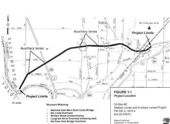 In July 2007, the CTC received notice of a draft EIR having been prepared for roadway improvements in and
near Sacramento. The alternative under consideration would connect to the
existing bus/carpool lanes that extend east from Watt Avenue to Placer
County. It would add a 12-foot bus/carpool lane in each direction from
Watt Avenue to West El Camino Avenue, add 12-foot eastbound and westbound
auxiliary lanes in two locations, from West El Camino Avenue to I-5 and
between Northgate Boulevard and Norwood Avenue, and install ramp metering
and bus/carpool bypass lane on-ramps at selected interchanges if feasible.
However, the project is not fully funded. The project is currently funded
for Project Approval and Environmental Document and Plans, Specifications
and Estimates for $9 million in Congestion Mitigation Air Quality funding.
The total estimated project cost is $200 million. Construction is
estimated to begin in Fiscal Year (FY) 2009-10. These were up for future
consideration of funding, the EIR having been completed, in April 2008.
In July 2007, the CTC received notice of a draft EIR having been prepared for roadway improvements in and
near Sacramento. The alternative under consideration would connect to the
existing bus/carpool lanes that extend east from Watt Avenue to Placer
County. It would add a 12-foot bus/carpool lane in each direction from
Watt Avenue to West El Camino Avenue, add 12-foot eastbound and westbound
auxiliary lanes in two locations, from West El Camino Avenue to I-5 and
between Northgate Boulevard and Norwood Avenue, and install ramp metering
and bus/carpool bypass lane on-ramps at selected interchanges if feasible.
However, the project is not fully funded. The project is currently funded
for Project Approval and Environmental Document and Plans, Specifications
and Estimates for $9 million in Congestion Mitigation Air Quality funding.
The total estimated project cost is $200 million. Construction is
estimated to begin in Fiscal Year (FY) 2009-10. These were up for future
consideration of funding, the EIR having been completed, in April 2008.
In October 2011, Caltrans broke ground on a $133 million freeway expansion project on I-80 through Natomas. Crews will build 10 miles of bus and carpool lanes on each side of the freeway, and add a one-mile auxiliary lane on the freeway between West El Camino Avenue ramps and the I-80 interchange with I-5. The freeway also will be repaved between West El Camino and Watt Avenue. Caltrans officials said they believe the project will reduce congestion and delays on the freeway. Officials intend to do most construction work at night to minimize daytime traffic delays. Project finish date is set for fall 2014. The project contractors are Bay Cities, Inc. of Concord and C.C. Myers Inc. of Rancho Cordova.
In January 2016, it was reported that C.C. Myers Inc.,
a Rancho Cordova-based construction company serving as lead contractor for
the 80 Across the Top project, has been forced to step aside due
to financial difficulties. Control of that project and several other
projects in Northern California have been transitioned to partnering
companies on Jan. 1, 2016. Bay Cities Paving and Grading of Concord, which
has served as Myers’ partner on the north Sacramento freeway
project, has taken over sole control. The project involves rebuilding and
widening 10 miles of the freeway from the Sacramento/Yolo county line to
just west of Watt Avenue. The project already has run into several delays
and may finish a year behind its original schedule. The work began in 2011
and is currently scheduled to be finished in summer or fall 2016.
(Source: Sacramento Bee, 1/11/2016)
In August 2016, I-80 had significant lane closures over
Labor Day weekendas part of this project. The closures were part of the
$133 million “Across the Top” project scheduled to be
completed in Fall 2016, according to the state Department of
Transportation. The project will add about 10 miles of carpool lanes in
both directions, repave the highway from east of the Sacramento River
Bridge to Watt Avenue and add about 1 mile of new auxiliary lanes from
West El Camino Avenue to the I-80 and I-5 interchange.
(Source: Sacramento Bee, 8/19/2016)
In November 2016, it was reported that Caltrans’
Across The Top freeway widening project will hit a landmark moment at the
end of November 2016 with the opening of a 10-mile carpool lane on the
westbound side, stretching from near Watt Avenue to the Yolo County line.
A similar lane in the opposite direction will open a few weeks later. The
project, launched in 2011, is now more than two years behind its
originally projected fall 2014 finish date. While the likely opening of
the carpool lanes in December is the last major step for the project, not
all the work is done. Crews will return next spring for finish work,
including smoothing out some rough sections of the new road surface.
Caltrans officials say they believe the public will like the end product,
which they described as two projects in one, a freeway widening coupled
with major reconstruction work. Crews ripped out and replaced four of the
freeway’s original six lanes, installed a new drainage system, built
several miles of soundwalls and added a series of auxiliary outer lanes
that run from one onramp to the next offramp. The main focus, though, is
the 10 miles of carpool and bus lanes designed to reduce congestion.
(Source: Sacramento Bee, 11/29/2016)
Citrus Heights and Rocklin
There are plans for freeway improvements in the area of Citrus Heights and Rocklin. Alternatives being discussed are in the CTC Background. The goal is to improve traffic flow between Auburn and Douglas Blvds in that area. (~ SAC R11.193 to PLA 1.944)
In August 2011, the CTC approved $7,000,000 in SHOPP funding for repairs near Sacramento, from Madison Avenue Overcrossing to Placer County Line (~ SAC 12.438 to PLA 0.000); also on Route 244 from Route 80 to Auburn Boulevard, that will rehabilitate 61.2 lane miles of roadway to improve the ride quality, prevent further deterioration of the traveling surface, minimize costly roadway repairs and extend the pavement service life.
In May 2009, Caltrans advertised a project involving I-80 HOV lanes in Roseville and Rocklin ($35 million). (~ SAC 16.766 to PLA 6.017 (WAG on PMs))
In September 2011, it was reported that Caltrans opened 2.8 miles of new "peak hour" bus/carpool lanes on I-80 in the Roseville Area. The eastbound and westbound HOV lanes are open from the Sacramento / Placer County line to just west of Miner's Ravine east of Douglas Boulevard. (~ PLA 0.000 to PLA 1.944)
Placer County I-80 Auxiliary Lane and 5th Lane Project (03-PLA-80 0.100/2.200)
 The SAFETEA-LU act, enacted in August 2005 as the reauthorization of TEA-21, provided the
following expenditures on or near this route:
The SAFETEA-LU act, enacted in August 2005 as the reauthorization of TEA-21, provided the
following expenditures on or near this route:
In 2006, the CTC discussed the scope of work for the I-80 Capacity/Operational Improvements parent project (PPNO 0146D), which includes the construction of eastbound and westbound HOV and auxiliary lanes from the Sacramento/Placer County line (PLA 0.0) to Route 65 (PLA 5.1). The project scope also includes upgrading the traffic monitoring system through the use of traffic sensors, closed circuit cameras, and changeable message signs. The estimate for the total project is currently $193,200,000. In December 2008, funding was reallocated to redistribute construction contract award savings realized from a low construction bid. The construction contract award savings will be used to cover the final expenditure costs of the environmental clearance and design components on Phase 2.
In May 2017, the CTC approved for future consideration of funding a project in Placer County that proposes to widen I-80 by adding an eastbound auxiliary lane between Route 65 and Rocklin Road, and by adding a westbound fifth through lane from 1,000 feet east of Douglas Boulevard to west of Riverside Avenue (03-Pla-80, PM 0.1/6.0). The project is not fully funded. The Project Approval and Environment Document is funded from local sources. The estimated capital outlay cost of the project is $14.4 million. Depending on the availability of funds, construction is estimated to begin in Fiscal Year 2019-20.
In August 2021, the CTC amended the following project
into the STIP: Capital Region Freight – I-80 project (PPNO 5101A, EA
3F231). 03-PLA-80 0.100/2.200. I-80 In Placer County, from Douglas
Boulevard to Riverside Avenue. In the westbound direction, the project
adds a 5th through lane on I-80 from east of Douglas Boulevard
to west of Riverside Avenue in the city of Roseville. This improvement
also includes reducing the existing I- 80 westbound two-lane off-ramp at
Douglas Boulevard to one-lane, and modifying the Douglas Boulevard
on-ramps, Riverside Avenue off-ramp and northbound on-ramp to accommodate
the new lane. Updated financials ($ × 1,000): R/W Cap: 486 ⇒
466; Const Cap 17,727 ⇒ 21,545; PA&ED 405; PS&E 1,564
⇒ 1,412; R/W Sup 0 ⇒ 115; Const Sup 2,118 ⇒ 2,955;
Total: 22,300 ⇒26,897.
(Source: August 2021 CTC Agenda, Agenda Item
2.1a.(2))
In June 2022, the CTC approved an allocation of
$17,932,000 for the State-Administered multi-funded SB1 Trade Corridor
Enhancement Program (TCEP)/State Transportation Improvement Program (STIP)
Capital Region Freight – I-80 project (PPNO 5101A). 03-Pla-80
0.1/2.2. PPNO 03-5101A; ProjID 0321000122; EA 3F231. Capital Region
Freight - I-80. On I-80 In Placer County, from Douglas Boulevard to
Riverside Avenue. In the westbound direction, the project adds a 5th
through lane on I-80 from east of Douglas Boulevard to west of Riverside
Avenue in the city of Roseville. This improvement also includes reducing
the existing I-80 westbound two-lane off-ramp at Douglas Boulevard to
one-lane, and modifying the Douglas Boulevard on-ramps, Riverside Avenue
off-ramp and northbound on-ramp to accommodate the new lane. Future
consideration of funding approved under Resolution E-17-21; May 2017.
Contribution from other sources: $4,427,000. Related SCCP allocation for
EA 3F231/PPNO 03-5101 under Resolution SCCP-A-2122-10; June 2022. EA
3F231, PPNO 5101A combined with EA 03-3F232, PPNO 5101 for construction
under EA 3F23U, Project ID 0322000243, PPNO 5101C. Allocations:
TCEP-S/21-22 CON ENG $2,118,000; CONST $4,402,000. TCEP-R/21-22 CONST
$9,780,000. COVID-RIP/22-23 CONST $1,632,000.
(Source: June 2022 CTC Agenda, Agenda Item 2.5s.(6)
/ 2.5v.(6))
In March 2023, the CTC approved the following
State-Administered multi-funded TCEP/STIP project allocation: $2,038,000.
03-Pla-80 Var. PPNO 03-5101A; ProjID 0321000122; EA 3F231. Capital
Region Freight - I-80. In Placer County, from Douglas Boulevard to
Riverside Avenue. In the westbound direction, the project adds a 5th
through lane on I-80 from east of Douglas Boulevard to west of Riverside
Avenue in the city of Roseville. This improvement also includes reducing
the existing I-80 westbound two-lane off-ramp at Douglas Boulevard to
one-lane, and modifying the Douglas Boulevard on-ramps, Riverside Avenue
off-ramp and northbound on-ramp to accommodate the new lane. Supplemental
funds are needed to Award. Total revised amount $19,970,000 EA 3F231, PPNO
5101A combined with EA 03-3F232, PPNO 5101 for construction under EA
3F23U, Project ID 0322000243, PPNO 5101C.
(Source: March 2023 CTC Agenda, Agenda Item 2.5s.(9))
In August 2023, it was reported that Caltrans held a
groundbreaking ceremony for the two construction projects on August 1,
covering construction along two miles-long stretches of the highway in
Roseville and Rocklin: the so-called “5th lane
project” and a new auxiliary lane. The projects are an effort to
improve travel times along I-80 through that area of Placer County. The
“5th lane project” involves the construction of a
fifth lane on westbound I-80 between Douglas Blvd. and Riverside Avenue, a
stretch of about two miles. This project will also change the Douglas
Blvd. offramp from westbound I-80, reducing it from two lanes to a single
lane. The second project where work has begun is the creation of an
auxiliary lane along a nearly two-mile stretch of eastbound I-80 between
Route 65 and Rocklin Road, and adding a second lane at the offramp to this
road.
(Source: Fox 40 News, 8/2/2023)
In March 2008, right of way in Roseville, on Riverside Avenue between Cirby Way and I-80 was relinquished (~ PLA 0.571).
Atlantic/Eureka Interstate-80 Westbound On-ramp Widening Project (03-Pla-80, PM 2.6/3.1)
 In October 2020, the CTC approved for future
consideration of funding the following project for which a Mitigated
Negative Declaration (MND) has been completed: I-80 in Placer County.
Expand the Atlantic/Eureka Westbound on-ramp and replace the Miner’s
Ravine Bridge on I-80 in Placer County. (03-Pla-80, PM 2.6/3.1) (PPNO
5113). This project is located on I-80 at the Atlantic Street/Eurkea Road
on-ramp in the City of Roseville in Placer County. The Department proposes
to expand the width of the Atlantic/Eureka/I-80 Westbound on-ramp and
replace the existing Miner’s Ravine Bridge to reduce traffic
congestion and comply with current design standards. This project is fully
funded and is currently programmed in the 2018 SHOPP for a total of
$11,200,000 which includes Construction (capital and support) and Right of
Way (capital and support). Construction is estimated to begin in 2021. The
scope, as described for the preferred alternative, is consistent with the
project scope programmed by the Commission in the 2018 SHOPP.
In October 2020, the CTC approved for future
consideration of funding the following project for which a Mitigated
Negative Declaration (MND) has been completed: I-80 in Placer County.
Expand the Atlantic/Eureka Westbound on-ramp and replace the Miner’s
Ravine Bridge on I-80 in Placer County. (03-Pla-80, PM 2.6/3.1) (PPNO
5113). This project is located on I-80 at the Atlantic Street/Eurkea Road
on-ramp in the City of Roseville in Placer County. The Department proposes
to expand the width of the Atlantic/Eureka/I-80 Westbound on-ramp and
replace the existing Miner’s Ravine Bridge to reduce traffic
congestion and comply with current design standards. This project is fully
funded and is currently programmed in the 2018 SHOPP for a total of
$11,200,000 which includes Construction (capital and support) and Right of
Way (capital and support). Construction is estimated to begin in 2021. The
scope, as described for the preferred alternative, is consistent with the
project scope programmed by the Commission in the 2018 SHOPP.
(Source: October 2020 CTC Agenda, Agenda Item
2.2c.(1))
Additionally, in October 2020, the CTC approved the
following allocation for construction: $10,868,000 for Placer 03-Pla-80 PM
2.6/3.1 PPNO 03-5113 ProjID 0315000174 EA 0H460. I-80 in Roseville, at the
Atlantic Street/Eureka Road westbound onramp. Outcome/Output:
Widen the ramp to accommodate two general purpose lanes and one High
Occupancy Vehicle (HOV) bypass lane, and install ramp meters. This project
will improve traffic mobility during peak hours. Con Eng $900,000; Const
$8,500,000. (CEQA - MND, 9/16/2019; Re-validation 6/18/2020) (NEPA - CE,
9/23/2019; Re-validation 6/18/2020) (Concurrent consideration of funding
under Resolution E -20-87; October 2020.)
(Source: October 2020 CTC Agenda, Agenda Item
2.5b.(1) #3)
Route 65/I-80 Interchange (~ PLA 3.039 to PLA 5.245)
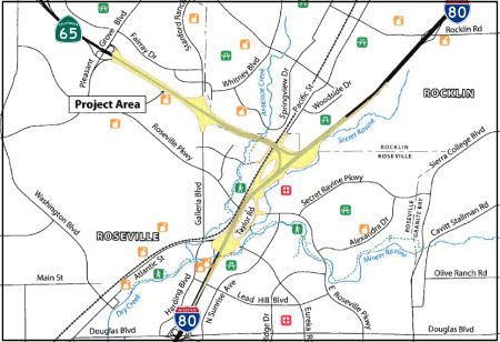 In March 2013, the CTC received notice of the preparation of an EIR. This EIR is for a
project that would add High Occupancy Vehicle lanes and high-speed
connections at the I-80/Route 65 Interchange in Placer County. The project
is not fully funded; however, the project is fully funded through the
Project Approval and Environmental Document phase with federal and local
funds. The total estimated cost is $340,000,000 for capital and support.
Construction is estimated to begin in Fiscal Year 2019-20, depending on
the availability of funds. There are five alternatives being considered:
(1) Taylor Road Full Access Interchange (Diamond-Shaped); (2) Taylor Road
Full Access Interchange (Trumpet-Shaped); (3) Taylor Road Interchange
Eliminated; (4) Transportation System Management; and (5) No-Build
(No-Project).
In March 2013, the CTC received notice of the preparation of an EIR. This EIR is for a
project that would add High Occupancy Vehicle lanes and high-speed
connections at the I-80/Route 65 Interchange in Placer County. The project
is not fully funded; however, the project is fully funded through the
Project Approval and Environmental Document phase with federal and local
funds. The total estimated cost is $340,000,000 for capital and support.
Construction is estimated to begin in Fiscal Year 2019-20, depending on
the availability of funds. There are five alternatives being considered:
(1) Taylor Road Full Access Interchange (Diamond-Shaped); (2) Taylor Road
Full Access Interchange (Trumpet-Shaped); (3) Taylor Road Interchange
Eliminated; (4) Transportation System Management; and (5) No-Build
(No-Project).
In December 2016, the CTC approved for future consideration of funding project in Placer County that will construct improvements to the I-80/Route 65 Interchange in the cities of Roseville and Rocklin. The overall project will be constructed in four phases. Phase 1 of this project will construct a northbound auxiliary lane from Route 80 to Galleria Boulevard/Stanford Ranch Road and install a ramp meter on Route 65. Phase 1 is programmed in the 2016 State Highway Operation and Protection Program. The total programmed amount for Phase 1 is $26,650,000 for capital and support. Construction is estimated to begin in Fiscal Year 2017-18. The scope, as described in the Purpose and Need of the environmental document, is consistent with the project scope programmed by the Commission in the 2016 State Highway Operation and Protection Program. Phases 2 through 4 are not fully funded. The total estimated cost for the overall project is $348,000,000 for capital and support.
In August 2017, the CTC approved $3,600,000 from the Budget Act of 2016, Budget Act Item 2660-304-6056 for the following locally administered Proposition 1B TCIF Program project: I-80/Route 65 Interchange Phase 1- Third Lane. In and near Roseville and Rocklin, from 0.4 mile north of Route 80 to 0.5 mile south of the Pleasant Grove Boulevard Overcrossing. Construct third lane for 1.3 miles. (TCIF 126). The local agency was ready to proceed with this project, and is requesting an allocation at this time. The allocation is contingent upon the approval of a budget revision by the Department of Finance. Future Consideration of Funding approved under Resolution E-16-92; December 2016.
In April 2018, construction was to begin on the Route 80/Route 65 interchange. The first phase will provide a third lane on
northbound Route 65 from I-80 to Pleasant Grove Boulevard and improvements
to the Galleria Boulevard/Stanford Ranch Road interchange. PCTPA and its
partners garnered several funding sources to complete the $50 million
first phase. The I-80 Bottleneck project through Roseville was completed
in 2011 under budget, thus, PCTPA is able to use nearly $10 million
dollars from that project savings. Other local funding sources include
traffic mitigation fees assessed on local developments. The remaining $400
million cost will eventually add one lane to each of the four connectors
between Route 65 and I-80. Future improvements also include maintaining
the existing I-80 access at Taylor Road and eliminating the weaving
movements on I-80 eastbound between Eureka Road and Route 65. However, in
the first phase, the interchange will retain its present configuration as
a trumpet with the heaviest movement around the loop rather than via the
direct SB to EB ramp. The interchange design did not include a reversed
connection to provide a higher-speed connection from I-80 east to Route 65
north. Apparently there was some concern about damage to the adjacent
watershed immediately to the south of the interchange, so the plans were
"massaged" to the present configuration to avoid impinging on the
identified problematic area. Because of funding limitations, a directional
interchange had not been considered, so the area required for the trumpet
had not only needed to be shifted NE along I-80, but also "squeezed" into
a tighter than usual profile so as not to impinge on an adjoining
creekbed; this accounts for the low-speed loop from EB I-80 to NB Route 65. According to Caltrans sources, there's no near-term funded plans to
effect basic changes to the present configuration except to expand
capacity on Route 65 so that the proximity of the regional commercial
center along that freeway to the north of the interchange doesn't result
in additional backup issues around the loop. It does appear that in future
phases, the interchange will become directional.
(Sources: 80/65 Interchange Improvement Project Website, 4/2018; Sparkeron
AAroads, 4/29/2018)
The SAFETEA-LU act, enacted in August 2005 as the reauthorization of TEA-21, provided the following expenditures on or near this route:
In August 2011, the CTC approved $8,200,000 in SHOPP funding for repairs near Rocklin, from 1 mile east of Route 65 Junction to 0.2 mile east of Route 193 Junction, that will rehabilitate 56.4 lane miles of roadway to improve the ride quality, prevent further deterioration of the traveling surface, minimize costly roadway repairs and extend the pavement service life. (~ PLA 5.017 to PLA 14.127)
In January 2012, the CTC approved for future consideration of funding a project in Placer County that will increase the vertical clearance of nine bridges on I-80 to meet the vertical clearance bridge height for permit vehicles. The project limits are approximately 29 miles long, running from Loomis to the Community of Magra , past Colfax, through Newcastle, and through Auburn (~ PLA 8.721 to PLA 38.412). The project is programmed in the 2010 SHOPP. The total estimated project cost is $36,045,000 for capital and support. Construction is estimated to begin in Fiscal Year 2012-13. The scope, as described for the preferred alternative, is consistent with the project scope programmed by the Commission in the 2010 SHOPP.
Auburn to the Nevada State Line
In October 2013, it was reported that Caltrans had completed rebuilding
the entire roadbed from Auburn to the Nevada state line. It took 15 years,
$820 million and countless lane closures and traffic slowdowns. The
original I-80 was built between 1957 and 1964 as part of the Federal
Highway Act. The old roadway was topped with 10-inch concrete slabs. The
new one has slabs that are 12 inches thick in key high-mountain sections.
That will give crews, in the years ahead, several extra inches of concrete
to grind flat when ruts get deep. The department also installed slabs of
different lengths on key sections of the freeway, in hopes of reducing the
rhythmic bouncing that happens to trucks when crossing from slab to slab.
Instead of same-length slabs, the new concrete sections are built in a
sequence of 10, 12, 14 and 16 feet. That should reduce truck up-and-down
movement. The series of renovation projects started in the late 1990s
after highway officials decided the freeway had outlived its functional
life. Caltrans first built a bypass route around Truckee. Since then, work
crews have jumped from spot to spot along the highway east of Auburn. An
estimated 3,000 workers participated, mainly from May to October each
year. In some places, the entire freeway was removed and replaced. At
several spots, the old freeway’s concrete was ground up and reused
in the base of the new freeway. At other spots, workers left the old
freeway in place, and glued a new concrete slab on top. Upgrades include
numerous water run-off detention ponds and sediment basins so that freeway
water is filtered before flowing to adjacent creeks. The agency put new
traffic sensors in the pavement and better lighting at exit and entrance
ramps. Workers replaced old post and cable barriers with concrete in
potential crash areas, and in spots where snow removal equipment sometimes
hits the barriers. Caltrans replaced bridge roadways and topped them with
a “sacrificial layer” of polyester concrete that can be
replaced every seven to 12 years without having to dig into the main road
surface.
(Source: Sacramento Bee, 10/2/13)
Weimar (~ 080 PLA 28.832) to Cisco Grove (~ 080 PLA R63.714) Bridge Replacement
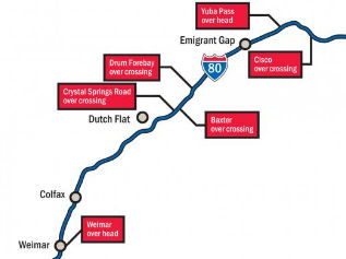 In January 2018, it was reported that Caltrans is targeting a 2021 start on a $53 million
project to rehabilitate or replace seven bridges from Weimar to Cisco
Grove. The Weimar overcrossing, just south of Colfax, along with bridges
over the freeway at Crystal Springs, Baxter, Drum Forebay, Yuba Pass and
Cisco are the subjects of a draft environmental report that is open for
public comment through Jan. 26, 2018. The report, a precursor to further
planning and construction, states the bridges are in need of major
rehabilitation or replacement due to cracking in the concrete decks,
crumbling concrete and high salt content that has leached into steel
bridge components. One of the topics of discussion for people attending
was the possibility of eliminating the Crystal Springs overcrossing and
its eastbound ramp. The Baxter and Crystal Springs overcrossings are less
than a mile apart and Caltrans is weighing the expenditure to rebuild the
latter, Whitmore said. One of the points made by local residents was that
the westbound offramp at Baxter is shorter than the one at Crystal Springs
and has a tight turn at the end. When work begins, Caltrans will close
down bridges in a way that motorists will be able to continue to the next
overcrossing to reverse course.
In January 2018, it was reported that Caltrans is targeting a 2021 start on a $53 million
project to rehabilitate or replace seven bridges from Weimar to Cisco
Grove. The Weimar overcrossing, just south of Colfax, along with bridges
over the freeway at Crystal Springs, Baxter, Drum Forebay, Yuba Pass and
Cisco are the subjects of a draft environmental report that is open for
public comment through Jan. 26, 2018. The report, a precursor to further
planning and construction, states the bridges are in need of major
rehabilitation or replacement due to cracking in the concrete decks,
crumbling concrete and high salt content that has leached into steel
bridge components. One of the topics of discussion for people attending
was the possibility of eliminating the Crystal Springs overcrossing and
its eastbound ramp. The Baxter and Crystal Springs overcrossings are less
than a mile apart and Caltrans is weighing the expenditure to rebuild the
latter, Whitmore said. One of the points made by local residents was that
the westbound offramp at Baxter is shorter than the one at Crystal Springs
and has a tight turn at the end. When work begins, Caltrans will close
down bridges in a way that motorists will be able to continue to the next
overcrossing to reverse course.
(Source: Auburn Journal, 1/15/2018)
In August 2018, the CTC approved for future
consideration of funding a project for which a Negative Declaration (ND)
has been completed: I-80 in Placer and Nevada Counties (03-Pla-80, PM
28.7/63.5). Rehabilitate and/or replace six existing bridges on I-80 in
Placer and Nevada Counties. (PPNO 5097) This project is located along I-80
in Placer and Nevada Counties. The project proposes to rehabilitate and/or
replace six bridges. The bridges are the Weimar Overhead (No. 19-0038),
Yuba Overhead (No. 17-0023), Crystal Springs Road Overcrossing (No.
19-0112), Baxter Overcrossing (No. 19-0113), Drum Overcrossing (No.
19-0114) and Cisco Overcrossing (No. 19-0118). The project proposes to
address the issues of concrete deck cracks, spalling concrete, and high
chloride content in the deck surfaces, superstructures and substructures.
The proposed project is estimated to cost $53.7 million. This project is
fully funded and is currently programmed in the 2018 SHOPP for
approximately $48.4 million. Construction is estimated to begin in 2020.
The scope, as described for the preferred alternative, is consistent with
the project scope programmed by the Commission in the 2018 SHOPP. A copy
of the ND has been provided to Commission staff. The project will result
in less than significant impacts to the environment. As a result, an ND
was completed for this project.
(Source: August 2018 CTC Agenda Item 2.2c(1))
In June 2019, the CTC approved the following SHOPP
scope amendment: 03-Pla-80 46.3/R63.5 PPNO 5097 ProjID 0300020615. On I-80
In Placer County, at various locations. Replace bridges at four locations.
It was discovered that at Crystal Springs Overcrossing, the north side
abutment is situated on highly saturated, unstable slope. The foundation
design necessitates the need for a cut-off wall and a series of horizontal
drains, resulting in an increase for construction capital. Relocating
fiber optic facilities at Cisco Overcrossing using boring and jacking
method prior to construction will eliminate the risk of construction
delays, but requires additional R/W capital. Updated total cost: $53,235K.
(Source: June 2019 CTC Minutes, Agenda Item
2.1a.(1) Scope Item 31)
In June 2020, the CTC approved the following allocation
for CONST and CON ENG: $46,642,000. 03-Pla-80 46.3/R63.5. PPNO 03-5097
ProjID 0300020615. EA 2F570. On I-80 near Dutch Flat and Cisco Grove, at
Crystal Springs Road Overcrossing No. 19-0112 (PM 46.3), Baxter
Overcrossing No. 19-0113 (PM 46.9), Drum Forebay Overcrossing No. 19-0114
(PM 49.0), and Cisco Overcrossing No. 19-0118 (PM R63.5). Outcome/Output:
Replace aging bridges at four locations. As part of this allocation
request, the Department is requesting to extend the completion of CONST
and CON ENG an additional 14 months beyond the 36 month deadline.
(Source: June 2020 CTC Agenda, Agenda Item 2.5b.(1)
#5)
In April 2021, it was reported that the Drum Forebay
Overcrossing No. 19-0114 (PM 49.0) and Crystal Springs Road Overcrossing
No. 19-0112 (PM 46.3) would be closed through December 2021 while they are
being demolished and rebuilt.
(Source: Caltrans District 3 Tweet, 4/29/2021)
Placer County Truck Climbing Lanes (03-Placer-80 PM R26.5/28.8, 39.5/41.3, 53.0/54.7)
Note: The middle segment of these lanes appears to connect with the Colfax Climbing Lanes (PLA 35.1/38.2) and the Gold Run Climbing Lanes (PLA 42.7/49.3)
 The 2020 SHOPP, approved in May 2020, included the following NEW Roadway
Preservation item of interest: 03-Placer-80 PM R26.5/28.8 PPNO 5131 Proj
ID 0318000017 EA 3H590. I-80 near Applegate, from east of Crother Road
Overcrossing to east of Weimar Overhead; also near Magra from PM 39.5 to
PM 41.3; also near Emigrant Gap from PM 53.0 to PM 54.7. Rehabilitate
roadway, construct truck climbing lanes in eastbound direction, widen
shoulders, replace or widen structures, upgrade median barrier and
Transportation Management System (TMS) elements. Programmed in FY22-23,
with construction scheduled to start in October 2023... however,
construction capital and construction support phases were not authorized.
Total project cost is $113,500K, with $94,500K being capital (const and
right of way) and $19,000K being support (engineering, environmental,
etc.).
The 2020 SHOPP, approved in May 2020, included the following NEW Roadway
Preservation item of interest: 03-Placer-80 PM R26.5/28.8 PPNO 5131 Proj
ID 0318000017 EA 3H590. I-80 near Applegate, from east of Crother Road
Overcrossing to east of Weimar Overhead; also near Magra from PM 39.5 to
PM 41.3; also near Emigrant Gap from PM 53.0 to PM 54.7. Rehabilitate
roadway, construct truck climbing lanes in eastbound direction, widen
shoulders, replace or widen structures, upgrade median barrier and
Transportation Management System (TMS) elements. Programmed in FY22-23,
with construction scheduled to start in October 2023... however,
construction capital and construction support phases were not authorized.
Total project cost is $113,500K, with $94,500K being capital (const and
right of way) and $19,000K being support (engineering, environmental,
etc.).
(Source: 2020 Approved SHOPP a/o May 2020)
In December 2021, the CTC amended the SHOPP as follows:
03-Pla-80 PM R26.5/28.8. PPNO 03-5131; ProjID 0318000017; EA 3H590. I-80
Near Applegate, from east of Crother Road Overcrossing to east of Weimar
Overhead; also near Magra from PM 39.5 to PM 41.3; also near Emigrant Gap
from PM 53.0 to PM 54.7. Rehabilitate roadway, construct truck climbing
lanes in eastbound direction, widen shoulders, replace or widen
structures, upgrade median barrier and Transportation Management System
(TMS) elements. Note: Increase R/W capital due to the need to acquire
additional parcels including a railroad easement and additional utility
relocations. Delay project by one year to allow additional time for
cultural resource studies caused by an increased project environmental
footprint. Allocation changes ($1000s; ⁍ indicates phase
not funded): ⁍Con Sup: FY22-23 ⇒ FY23-24; R/W Cap:
$1,000 FY22-23 ⇒ $2,972 FY 23-24; ⁍Const Cap
FY22-23 ⇒ FY23-24. Total $113,500 ⇒ $115,472.
(Source: December 2021 CTC Agenda, Agenda Item
2.1a.(1d) #3)
In December 2022, the CTC approved a request for an
additional $1,800,000 (45.0 percent increase) in Pre-Construction Support,
Project Approval and Environmental Document (PA&ED) phase, for the
SHOPP Roadway Rehabilitation project on I-80, in Placer County. (EA 3H590,
PPNO 5131). This project is located on I-80 in Placer County at three
different locations: Location 1) near Applegate, from east of Crother Road
Overcrossing to east of Weimar Overhead, from postmile R26.5 to 28.8,
Location 2) near Magra, from postmile 39.5 to 41.3, and Location 3) near
Emigrant Gap, from postmile 53.0 to 54.7. The project will rehabilitate
the roadway, construct truck climbing lanes in the eastbound
direction, widen shoulders, replace or widen structures,
upgrade median barrier and install Transportation Management System
elements. The project realized cost increases due to the flattening of
side slopes to avoid risks during construction. During the project
initiation phase of the project, the Department anticipated using steeper
side slopes for the widening of the roadway. This resulted in keeping the
environmental study limits within the existing State right of way and in
line with recently designed projects in the vicinity. The support
resources for the PA&ED phase were programmed accordingly. However,
upon further investigations during the PA&ED phase, the
Department’s Geotechnical Services Division determined that
incorporating steeper side slopes would have a high risk of causing slide
damage during construction. Based on this preliminary analysis, the
Department flattened the side slopes to avoid the construction risks
associated with steeper side slopes. As a result, a larger environmental
footprint of the project area needs to be studied, which included areas
outside of State’s right of way. This also requires additional
efforts to obtain permits to enter to allow access to these areas. These
locations contain unknown areas of cut/fill and numerous built and buried
environmental resources that require evaluation. As part of the PA&ED
studies, and to meet State and Federal requirements, the Department needs
to conduct, inspect, and analyze unanticipated cultural, biological, and
archeological resource studies. The findings from the cultural studies
will help determine the mitigation strategy.
(Source: December 2022 CTC Agenda, Agenda Item
2.5e.(5))
In May 2023, the CTC approved for future consideration
of funding the following project for which a Negative Declaration (ND) has
been completed: I-80 in Placer County (03-Pla-80, PM R26.5/55.1).
Rehabilitate the roadway, construct truck climbing lanes, widen shoulders,
replace or widen structures, and upgrade median barrier and Transportation
Management System (TMS) elements on I-80, in Placer County. (PPNO 5131)
The project is located on I-80 from postmile R26.5 to PM 55.1 in Placer
County. The Department proposes to rehabilitate roadway, construct truck
climbing lanes, widen shoulders, replace or widen structures, and upgrade
median barrier and TMS elements. The project is currently programmed in
the 2022 State Highway Operation and Protection Program (SHOPP) for a
total of $115,472,000, of which $103,000,000 is through G13 Contingency.
Construction is estimated to begin 2024-25. The scope, as described for
the preferred alternative, is consistent with the project scope as
programmed by the Commission in the 2022 SHOPP.
(Source: May 2023 CTC Agenda, Agenda Item 2.2c.(1))
In June 2023, the CTC amended the following project in
the 2022 SHOPP: 03-Pla-80 R26.5/28.8 R26.5/29.3.
PPNO 03-5131; ProjID 0318000017; EA 3H590. I-80 Near Applegate, from east
of Crother Road Overcrossing to east of Weimar Overhead; also near Magra
from PM 39.5 to PM 41.3 41.4; also near Emigrant
Gap from PM 53.0 to PM 54.7 R55.1. Rehabilitate
roadway, construct truck climbing lanes in eastbound direction, widen
shoulders, replace or widen structures, upgrade median barrier and
Transportation Management System (TMS) elements. Note: Update the
postmile limits, project description, and performance as the refinement in
design has changed the strategy from restriping to widening at one
location, and operational and safety needs extended the merge taper of the
truck climbing lane at the second location. Allocation ($ × 1,000):
PA&ED $4,000; PS&E $5,000; R/W Sup $500; ⊘Con
Sup $9,500; R/W Cap $2,972; ⊘Const
Cap $93,500; TOTAL $115,472. FY23-24.
(Source: June 2023 CTC Agenda, Agenda Item 2.1a.(1d) #13)
In August 2023, the CTC approved the following SHOPP
SB1 Primary Class Project Pre-Construction Phase (environmental support,
design, and R/W support) allocation: $5,000,000. 03-Pla-80 R26.5/29.3.
PPNO 03-5131; ProjID 0318000017; EA 3H590. I-80 Near Applegate, from east
of Crother Road Overcrossing to east of Weimar Overhead; also near Magra
from PM 39.5 to PM 41.4; also near Emigrant Gap from PM 53.0 to PM R55.1.
Rehabilitate roadway, construct truck climbing lanes in eastbound
direction, widen shoulders, replace or widen structures, upgrade median
barrier and Transportation Management System (TMS) elements. Future
consideration of funding approved under Resolution E-23-52; May 2023.
Sixteen month allocation time extension for PS&E approved under Waiver
22-73; June 2022. Allocation: PS&E $5,000,000.
(Source: August 2023 CTC Agenda, Agenda Item 2.5b.(2b) #6)
Colfax Roundabout (~ 03-Pla-080 PM 33.206)
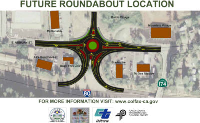 In November 2017, it was reported that the City of Colfax
plans to construct a roundabout that will tie in the existing I-80 ramps
and provide access to the properties west of South Auburn Street (Approx
03-Pla-080 PM 33.206). Sidewalks will be included on the west side of the
South Auburn Street, providing a safe route for pedestrians to walk and a
more efficient and safe route for cars to navigate the intersection.
Funding for this project was a combined effort between the City of Colfax,
Caltrans, Maidu Village Travel Plaza and the Placer County Transportation
Planning Agency (PCTPA). The intersection is currently controlled by an
all-way stop (stop signs). Unfortunately, the intersection isn’t
keeping-up with the increasing traffic demands and needs to be upgraded to
a modern roundabout. The decision to move the project improvements forward
was based on an October 2016 Study that evaluated different traffic
control methods including a 4-way stop with more lanes, signalization, and
a roundabout. A roundabout was clearly identified as the most suitable
traffic control system. The project components include: (•) A
dedicated southbound lane for the I-80 on-ramp; (•) Access to the
undeveloped parcel to the west; (•) Pedestrian and bicycle
facilities; (•) A precisely designed traffic roundabout that can
accommodate semi-trucks; (•) Yield signs and traffic channelizers at
all entry approaches of roundabout to regulate and deflect traffic;
(•) High visibility pedestrian crosswalks, and (•) Resurfacing
of South Auburn Street within project limits.
In November 2017, it was reported that the City of Colfax
plans to construct a roundabout that will tie in the existing I-80 ramps
and provide access to the properties west of South Auburn Street (Approx
03-Pla-080 PM 33.206). Sidewalks will be included on the west side of the
South Auburn Street, providing a safe route for pedestrians to walk and a
more efficient and safe route for cars to navigate the intersection.
Funding for this project was a combined effort between the City of Colfax,
Caltrans, Maidu Village Travel Plaza and the Placer County Transportation
Planning Agency (PCTPA). The intersection is currently controlled by an
all-way stop (stop signs). Unfortunately, the intersection isn’t
keeping-up with the increasing traffic demands and needs to be upgraded to
a modern roundabout. The decision to move the project improvements forward
was based on an October 2016 Study that evaluated different traffic
control methods including a 4-way stop with more lanes, signalization, and
a roundabout. A roundabout was clearly identified as the most suitable
traffic control system. The project components include: (•) A
dedicated southbound lane for the I-80 on-ramp; (•) Access to the
undeveloped parcel to the west; (•) Pedestrian and bicycle
facilities; (•) A precisely designed traffic roundabout that can
accommodate semi-trucks; (•) Yield signs and traffic channelizers at
all entry approaches of roundabout to regulate and deflect traffic;
(•) High visibility pedestrian crosswalks, and (•) Resurfacing
of South Auburn Street within project limits.
(Source: PCTPA Facebook Post, 11/15/2017; City of Colfax Website)
Colfax Climbing Lanes (PLA 35.1 to PLA 38.2)
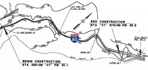 In June 2014, the CTC approved for future consideration
of funding a project in Placer County that will construct a three mile
long truck climbing lane on eastbound I-80 between Long Ravine Underpass
and Alpine Overcrossing-Secret Town Road (near Colfax), and replace the
Cape Horn Undercrossing. The project is programmed in the 2014 State
Highway Operation and Protection Program. The total estimated cost is
$44,450,000 for capital and support. Construction is estimated to begin in
Fiscal Year 2015-16. The scope, as described for the preferred
alternative, is consistent with the project scope programmed by the
Commission in the 2014 State Highway Operation and Protection Program.
In June 2014, the CTC approved for future consideration
of funding a project in Placer County that will construct a three mile
long truck climbing lane on eastbound I-80 between Long Ravine Underpass
and Alpine Overcrossing-Secret Town Road (near Colfax), and replace the
Cape Horn Undercrossing. The project is programmed in the 2014 State
Highway Operation and Protection Program. The total estimated cost is
$44,450,000 for capital and support. Construction is estimated to begin in
Fiscal Year 2015-16. The scope, as described for the preferred
alternative, is consistent with the project scope programmed by the
Commission in the 2014 State Highway Operation and Protection Program.
In August 2015, the CTC allocated $1,238,000 of federal earmarked Interstate Maintenance Discretionary (IMD) program dollars for the Colfax Truck Climbing Lane project. This was allocated from the Budget Act of 2014, Budget Act Item 2660-302-0890, for the State administered federal earmarked project.
In August 2016, it was reported that Caltrans is making
way for an additional right-hand lane to accommodate trucks as they slowly
make their way up the steep grade E of Colfax. The three-mile truck
climbing lane project will also add 10-foot-wide shoulders, widen the Cape
Horn Undercrossing, construct a 1,100-foot retaining wall separating Magra
Road from I-80 and result in other roadway improvements. The $50.3 million
project should be completed in late 2018.
(Source: SJ Mercury News/Mr. Roadshow, 8/26/2016)
 I-80 is the only place to see California' first attempt
at official mile marking, the G61R sign. There were two versions. The
G61R-1 had white 6 inch whole numbers and a white 4 inch decimal on a
green background and no other information. The G61R-2 was identical to the
G61R-1 but it added a white 3 inch county abbreviation at the top, much
like what we see on California postmile markers today. If the mileage had
more than 3 digits, the county abbreviation was to be removed. The G61R-2
was not to be used on Interstate routes. An example of a G61R (see the
picture to the right, courtesy of Jason Elliot of Oregon Roads and Reno Roads) may be seen along I-80 travelling east towards Reno from
Truckee, at about 1—1½ miles from the California-Nevada border
on the California side, there is one of the original mile marker signs.
This sign has a dark-green background with darkened text and reads 2080.
The numbers on the side are rotated the same direction and way as modern
postmiles. There is/was another along I-80 eastbound in Placer County,
between PM 36.0 and 37.0: it reads 1430. According to Eric
Buchanan's Highway Photo Page, there is another one around mile 155
(probably around PM 48.0 Placer or so) as well as one on Business Route 80 "just past
99 south."
I-80 is the only place to see California' first attempt
at official mile marking, the G61R sign. There were two versions. The
G61R-1 had white 6 inch whole numbers and a white 4 inch decimal on a
green background and no other information. The G61R-2 was identical to the
G61R-1 but it added a white 3 inch county abbreviation at the top, much
like what we see on California postmile markers today. If the mileage had
more than 3 digits, the county abbreviation was to be removed. The G61R-2
was not to be used on Interstate routes. An example of a G61R (see the
picture to the right, courtesy of Jason Elliot of Oregon Roads and Reno Roads) may be seen along I-80 travelling east towards Reno from
Truckee, at about 1—1½ miles from the California-Nevada border
on the California side, there is one of the original mile marker signs.
This sign has a dark-green background with darkened text and reads 2080.
The numbers on the side are rotated the same direction and way as modern
postmiles. There is/was another along I-80 eastbound in Placer County,
between PM 36.0 and 37.0: it reads 1430. According to Eric
Buchanan's Highway Photo Page, there is another one around mile 155
(probably around PM 48.0 Placer or so) as well as one on Business Route 80 "just past
99 south."
Gold Run Climbing Lanes (03-Placer-80 PM 42.7/49.3)
The 2020 SHOPP, approved in May 2020, included the
following NEW Roadway Preservation item of interest: 03-Placer-80 PM
42.7/49.3 PPNO 5133 Proj ID 0318000019 EA 3H610. I-80 near Gold Run, from
west of Monte Vista Overcrossing to east of Drum Forebay Overcrossing (PM
42.7/49.3R). Rehabilitate roadway, construct truck climbing lane, replace
or widen structures, upgrade median concrete barrier, sign panels, and
Transportation Management System (TMS) elements, and rehabilitate drainage
systems.. Programmed in FY22-23, with construction scheduled to start in
September 2023. Total project cost is $76,860K, with $64,130K being
capital (const and right of way) and $12,730K being support (engineering,
environmental, etc.).
(Source: 2020 Approved SHOPP a/o May 2020)
In March 2022, the CTC adopted the 2022 SHOPP, which
amended the following project already in the SHOPP: 03-Placer-80 PM
42.7/49.3 PPNO 5133 Proj ID 0318000019 EA 3H610. I-80 near Gold Run, from
west of Monte Vista Overcrossing to east of Drum Forebay Overcrossing (PM
42.7/49.3R). Rehabilitate roadway, construct truck climbing lane, replace
or widen structures, upgrade median concrete barrier, sign panels, and
Transportation Management System (TMS) elements, and rehabilitate drainage
systems.. The amendment changed the programmed funding: R/W Cap from
$1,430K to $2,165K, and Const Cap from $62,700K to $78,688K, for a new
total of $93,583K. Reason: Increase R/W capital because field
investigations indicate that some utilities have potential conflicts and
require protection in place. Increase construction capital because the
initial proposal to reduce inside shoulder to add truck climbing lane is
no longer feasible. Widening of outside shoulder and construction of
retaining walls are needed to add a truck climbing lane, resulting in
increased costs.
(Source: March 2022 CTC Agenda, Agenda Item 4.25
(SHOPP Adoption), Attch. C (List of 2022 SHOPP Amendments (Cost, Scope,
Schedule and Technical Changes. Includes Federal Emergency Relief.) ),
Item #5)
In October 2022, the CTC approved the following
pre-construction phase allocation: $3,814,000. 03-Pla-80 42.7/49.3. PPNO
03-5133; ProjID 0318000019; EA 3H610. I-80 Near Gold Run, from west of
Monte Vista Overcrossing to east of Drum Forebay Overcrossing (PM
42.7/49.3R). Rehabilitate roadway, construct truck climbing lane, replace
or widen structures, upgrade median concrete barrier, sign panels, and
Transportation Management System (TMS) elements, and rehabilitate drainage
systems. Programmed (Actual) allocation: FY22-23 PS&E $3,000,000
($3,584,000); R/W Sup $230,000 ($230,000). Concurrent consideration of
funding under Resolution E-22-76; October 2022.
(Source: October 2022 CTC Agenda, Agenda Item 2.5b.(2b) #4)
Soda Springs Pavement Rehabilitation Project (03-Pla-80, PM 68.3/69.7, 03-Nev-80, PM 0.0/R2.7)
 The 2020 SHOPP, approved in May 2020, included the following NEW Roadway
Preservation item of interest: 03-Nevada-80 PM 0.0/R2.7 PPNO 5111 Proj ID
0317000043 EA 1H990. I-80 near Kingvale, from Placer County line to east
of Donner Pass Road (PM 0.0/R2.7L/R); also in Placer County, from west of
Troy Road Undercrossing to Nevada County line (PM 68.5/69.7). Rehabilitate
roadway, construct truck climbing lane in eastbound direction, widen
Kingvale Undercrossing № 19-0107R, replace sign panels, upgrade
lighting and Transportation Management System (TMS) elements, and
rehabilitate drainage systems. Programmed in FY22-23, with construction
scheduled to start in September 2023. Total project cost is $85,590K, with
$70,090K being capital (const and right of way) and $15,500K being support
(engineering, environmental, etc.).
The 2020 SHOPP, approved in May 2020, included the following NEW Roadway
Preservation item of interest: 03-Nevada-80 PM 0.0/R2.7 PPNO 5111 Proj ID
0317000043 EA 1H990. I-80 near Kingvale, from Placer County line to east
of Donner Pass Road (PM 0.0/R2.7L/R); also in Placer County, from west of
Troy Road Undercrossing to Nevada County line (PM 68.5/69.7). Rehabilitate
roadway, construct truck climbing lane in eastbound direction, widen
Kingvale Undercrossing № 19-0107R, replace sign panels, upgrade
lighting and Transportation Management System (TMS) elements, and
rehabilitate drainage systems. Programmed in FY22-23, with construction
scheduled to start in September 2023. Total project cost is $85,590K, with
$70,090K being capital (const and right of way) and $15,500K being support
(engineering, environmental, etc.).
(Source: 2020 Approved SHOPP a/o May 2020)
In January 2022, it was reported that Caltrans was
seeking public feedback on two proposed I-80 improvement projects in
Placer and Nevada counties. A $101.8 million project proposes to replace
and widen the Yuba Pass Separation Overhead (SOH) bridges near the Route 20 separation in Nevada County. The project would improve freight
efficiency along I-80 by increasing the load carrying capacity and address
structural deficiencies that necessitate bridge replacement: concrete
cracking and spalling, high corrosive chloride content, superstructure
repainting, bridge deck concrete degradation, and weight-bearing pad
failures. A second $85.2 million project proposes to rehabilitate a
portion of I-80 in both Placer and Nevada counties, from just west of the
Troy Road undercrossing to just east of the Soda Springs overcrossing.
This project would repair distressed pavement and bridge decks on the
existing eastbound and westbound lanes and shoulders, construct an
eastbound truck climbing lane, and widen and replace the eastbound Troy
Road and Kingvale undercrossings. Existing culverts will be repaired,
replaced, or extended as needed. Detector loops on the mainline as well as
existing overhead sign structures and sign panels will be replaced.
(Source: District 3 on FB, 1/6/2022)
In March 2022, the CTC adopted the 2022 SHOPP, which
amended the following project already in the SHOPP: 03-Nevada-80 PM
0.0/R2.7 PPNO 5111 Proj ID 0317000043 EA 1H990. I-80 near Kingvale, from
Placer County line to east of Donner Pass Road (PM 0.0/R2.7L/R); also in
Placer County, from west of Troy Road Undercrossing to Nevada County line
(PM 68.3 68.5/69.7). Rehabilitate roadway,
construct truck climbing lane in eastbound direction, widen replace
Kingvale Undercrossing № 19-0107R and Troy Road Undercrossing
№ 19-0106R, replace sign panels, upgrade lighting and
Transportation Management System (TMS) elements, and rehabilitate drainage
systems. Programmed in FY22-23, with construction scheduled to start in
September 2023. Revisions to programmed funding (× $1000): R/W Cap
$1,687; Const Cap $70,239; Total $87,426. Note: The original scope
proposed to widen Kingvale Undercrossing and restripe Troy Road
Undercrossing to accommodate the truck climbing lane. Further studies
recommend that both aging structures be replaced with new wider bridges,
thus increasing construction capital. Increase R/W capital as some
utilities need protection in place or relocation. Update performance to
count only the slabs being repaired instead of total project lane miles.
(Source: March 2022 CTC Agenda, Agenda Item 4.25
(SHOPP Adoption), Attch. C (List of 2022 SHOPP Amendments (Cost, Scope,
Schedule and Technical Changes. Includes Federal Emergency Relief.)))
In May 2022, the CTC approved for
future consideration of funding the following project for which a
Mitigated Negative Declaration (MND) has been completed: 03-Pla-80, PM
68.3/69.7, 03-Nev-80, PM 0.0/R2.7. Soda Springs Pavement Rehabilitation
Project. Repair distressed pavement, construct a truck climbing lane, and
widen and replace undercrossing structures on I-80 in Placer and Nevada
counties. (PPNO 5111). The project is located on I-80 between postmile
68.3 and 69.7 in Placer County, and between postmile 0.0 and R2.7 in
Nevada County. The proposed project would repair distressed pavement on
the eastbound and westbound lanes and shoulders, construct an eastbound
truck climbing lane, and widen/replace the eastbound Troy and Kingvale
undercrossing structures. The project would also repair, replace, or
extend culverts as needed, add detector loops on the mainline and Soda
Springs ramps, and replace existing overhead sign structures and sign
panels. This project is currently programmed in the 2022
State Highway Operation and Protection Program (SHOPP) for a total of
$86,426,000, of which, $79,239,000 is currently through G-13 Contingency.
Construction is estimated to begin in October 2023. The scope, as
described for the preferred alternative, is consistent with the project
scope as programmed by the Commission in the 2022 SHOPP. A copy of the MND
has been provided to Commission staff. The project will result in less
than significant impacts to the environment.
(Source: May 2022 CTC Agenda, Agenda Item 2.2c.(1))
In May 2022, the CTC approved the following
pre-construction phase SB1 SHOPP allocation: $4,084,000. 03-Nev-80
0.0/R2.7. PPNO 03-5111; ProjID 0317000043; EA 1H990. I-80 Near Kingvale,
from Placer County line to east of Donner Pass Road (PM 0.0/R2.7L/R); also
in Placer County, from west of Troy Road Undercrossing to Nevada County
line (PM 68.3/69.7). Rehabilitate roadway, construct truck climbing lane
in eastbound direction, replace Kingvale Undercrossing № 19-0107R
and Troy Road Undercrossing № 19-0106R, replace sign panels, upgrade
lighting and Transportation Management System (TMS) elements, and
rehabilitate drainage systems. (Concurrent consideration of funding under
Resolution E-22-26; May 2022.) Allocation: FY22-23 PS&E $3,584,000
($3,000,000 Programmed); R/W Sup $500,000.
(Source: May 2022 CTC Agenda, Agenda Item 2.5b.(2b) #4)
In October 2022, the CTC approved the following SHOPP
amendment: 03-Nev-80 0.0/R2.7. PPNO 03-5111; ProjID 0317000043; EA 1H990.
I-80 Near Kingvale, from Placer County line to east of Donner Pass Road
(PM 0.0/R2.7L/R); also in Placer County, from west of Troy Road
Undercrossing to Nevada County line (PM 68.3/69.7). Rehabilitate roadway,
construct truck climbing lane in eastbound direction, replace Kingvale
Undercrossing № 19-0107R and Troy Road Undercrossing №
19-0106R, replace sign panels, upgrade lighting and Transportation
Management System (TMS) elements, and rehabilitate drainage systems.
Allocation Changes ($ × 1,000): Con Sup $0 ⇨ $9,000; Const Cap:
$0 ⇨ $70,239; Total $8,187 ⇨ $87,426. Note: Fully program
previously unfunded phases of this G13 Contingency project.
(Source: October 2022 CTC Agenda, Agenda Item
2.1a.(1d) #4)
In June 2023, the CTC approved the following SHOPP
Construction Phase allocation: $88,450,000. 03-Nev-80 0.0/R2.7. PPNO
03-5111; ProjID 0317000043; EA 1H990. I-80 Near Kingvale, from Placer
County line to 0.2 mile east of Donner Pass Road (PM 0.0/R2.7L/R); also in
Placer County, from 0.2 mile west of Troy Road Undercrossing to Nevada
County line (PM 68.3/69.7). Outcome/Output: Rehabilitate roadway,
construct truck climbing lane in eastbound direction, replace Kingvale
Undercrossing № 19-0107R and Troy Road Undercrossing №
19-0106R, replace sign panels, upgrade lighting and Transportation
Management System (TMS) elements, and rehabilitate drainage systems. This
project will improve safety and ride quality. Preliminary Engineering:
Budget / Expended: PA&ED $3,000,000 / $2,998,334;
PS&E $3,584,000 / $2,948,565; R/W Sup $500,000 / $71,258.
CEQA - MND, 2/24/2022; Re-validation 5/5/2023. NEPA - CE, 2/24/2022;
Re-validation 5/5/2023. Future consideration of funding approved under
Resolution E-22-26; May 2022. As part of this allocation request, the
Department is requesting to extend the completion of CONST and CON ENG an
additional 9 months beyond the 36 month deadline. Allocation (Programmed /
Funded): CON ENG $9,000,000 / $9,000,000;
CONST $70,239,000 / $79,450,000.
(Source: June 2023 CTC Agenda, Agenda Item 2.5b.(1a) #4)
Truckee Auxiliary Lanes: Donner Pass Road Overcrossing to Route 89/Route 267 Aux Lanes (03-Nev-80 PM 13.0/16.5)
 (PPNO 4294) The 2020 SHOPP, approved in May 2020,
included the following NEW Roadway Preservation item of interest:
03-Nevada-80 PM 13.0/15.5 PPNO 4294 Proj ID 0316000064 EA 1H180. I-80 in
Truckee, from west of Donner Pass Road Overcrossing to Bridge Street
Undercrossing (PM 13.04/15.5). Rehabilitate roadway, construct auxiliary
lane, upgrade Transportation Management System (TMS) elements,
rehabilitate drainage systems, and upgrade facilities to Americans with
Disabilities Act (ADA) standards. Programmed in FY22-23, with construction
scheduled to start in August 2023. Total project cost is $20,795K, with
$15,955K being capital (const and right of way) and $4,840K being support
(engineering, environmental, etc.).
(PPNO 4294) The 2020 SHOPP, approved in May 2020,
included the following NEW Roadway Preservation item of interest:
03-Nevada-80 PM 13.0/15.5 PPNO 4294 Proj ID 0316000064 EA 1H180. I-80 in
Truckee, from west of Donner Pass Road Overcrossing to Bridge Street
Undercrossing (PM 13.04/15.5). Rehabilitate roadway, construct auxiliary
lane, upgrade Transportation Management System (TMS) elements,
rehabilitate drainage systems, and upgrade facilities to Americans with
Disabilities Act (ADA) standards. Programmed in FY22-23, with construction
scheduled to start in August 2023. Total project cost is $20,795K, with
$15,955K being capital (const and right of way) and $4,840K being support
(engineering, environmental, etc.).
(Source: 2020 Approved SHOPP a/o May 2020)
(PPNO 4318) In October 2020, the CTC amended the
following Capital Project into the SHOPP: 03-Nev-80 PM 13.1/16.5. PPNO
4318 ProjID 0321000035 EA 1H181. I-80 in Truckee, from west of Donner Park
Overcrossing to Route 80/Route 89/Route 267 Separation (PM 13.05/16.5).
Construct auxiliary lanes and an acceleration lane. PA&ED: $350K;
PS&E: $350K; R/W Sup: $100K; Con Sup: $500K; R/W Cap: $17K; Const Cap:
$3,700K; Total: $5,017K. Begin Const: 11/20/2021.
(Source: October 2020 CTC Agenda, Agenda Item
2.1a.(1a) #30)
(PPNO 4318) In October 2020, the CTC approved the
following SHOPP Support Phase allocation: $350,000 for PA&ED for
03-Nev-80 PM 13.1/16.5. PPNO 03-4318 ProjID 0321000035 EA 1H181. I-80 In
Truckee, from west of Donner Park Overcrossing to I-80/Route 89/Route 267
Separation (PM 13.05/16.5). Construct auxiliary lanes and an acceleration
lane. (Concurrent Amendment under SHOPP Amendment 20H-003; October 2020.)
(Source: October 2020 CTC Agenda, Agenda Item
2.5b.(2a) #8)
In January 2021, the CTC approved the following
pre-construction SB1 support phase allocation(s): (2b) #1. $1,600,000
(PS&E); $120,000 (R/W Sup). 03-Nev-80 13.0/15.5. PPNO 03-4294; ProjID
0316000064; EA 1H180. I-80 In Truckee, from west of Donner Pass Road
Overcrossing to Bridge Street Undercrossing (PM 13.04/15.5). Rehabilitate
roadway, construct auxiliary lane, upgrade Transportation Management
System (TMS) elements, rehabilitate drainage systems, and upgrade
facilities to Americans with Disabilities Act (ADA) standards. Prog Year
22-23.
(Source: January 2021 CTC Agenda, Agenda Item
2.5b.(2b) #1)
(PPNO 4294) In March 2021, the CTC amended this project
in the SHOPP: (1d) #6. 03-Nev-80 13.0/15.5 13.04/16.5
PPNO 4294 ProjID 0316000064 EA 1H180. I-80 In Truckee, from west of Donner
Pass Road Overcrossing to Bridge Street Undercrossing Route 80/Route 89/Route 267 Separation (PM 13.04/15.5).
Rehabilitate roadway, construct auxiliary lane, upgrade Transportation
Management System (TMS) elements, rehabilitate drainage systems, and
upgrade facilities to Americans with Disabilities Act (ADA) standards.
This project was amended to combine it with project EA 1H181/PPNO 03-4318
to improve construction efficiencies and reduce impact to traveling
public, resulting in updates to postmiles, description and schedule.
Increase construction capital from $15,600K to $20,430K to address work
required on the inside shoulders, additional slab replacement, and rut
repair. Update performance due to change in methodology to count only the
slabs being repaired instead of total project lane miles.
(Source: March 2021 CTC Agenda, Agenda Item
2.1a.(1d) #6)
In March 2021, the CTC approved the following
pre-construction support phase allocation(s): (2a) #6. $350,000
(PS&E); $100,000 (R/W Sup). 03-Nev-80 13.1/16.5. PPNO 03-4318; ProjID
0321000035; EA 1H181. I-80 In Truckee, from west of Donner Park
Overcrossing to Route 80/Route 89/Route 267 Separation (PM 13.05/16.5).
Construct auxiliary lanes and an acceleration lane. Prog. year 20-21.
(Source: March 2021 CTC Agenda, Agenda Item
2.5b.(2a) #6)
In August 2021, the CTC approved the following
construction phase allocation: $22,827,000. 03-Nev-80 13.04/16.5. PPNO
03-4294; ProjID 0316000064; EA 1H180. I-80 In Truckee, from 0.1 mile west
of Donner Park Overcrossing to Route 80/89/267 Separation. Outcome/Output:
Rehabilitate roadway by grinding and placing Hot Mix Asphalt (HMA),
construct auxiliary lane, upgrade Transportation Management System (TMS)
elements, rehabilitate drainage systems, and upgrade facilities to
Americans with Disabilities Act (ADA) standards. This project will improve
safety and ride quality. Allocation: CON ENG $2,000,000 CONST $20,430,000.
(EA 1H180/PPNO 03-4294 combined with EA 1H181/PPNO 03-4318 for
construction under EA 1H18U/Project ID 0321000106.)
(Source: August 2021 CTC Agenda, Agenda Item
2.5b.(1) #14)
Also in August 2021, the CTC approved the following
construction phase allocation: $4,200,000. 03-Nev-80 13.05/16.5. PPNO
03-4318; ProjID 0321000035; EA 1H181. I-80 In Truckee, from 0.1 mile west
of Donner Park Overcrossing to Route 80/89/267 Separation. Outcome/Output:
Construct three auxiliary lanes and an acceleration lane to reduce
congestion and improve highway operations and mobility. Allocation: CON
ENG $500,000 CONST $3,700,000. (EA 1H181/PPNO 03-4318 combined with EA
1H180/PPNO 03-4294 for construction under EA 1H18U/Project ID 0321000106.)
(Two month time extension for CONST and CON ENG approved under Waiver
21-59; June 2021.)
(Source: August 2021 CTC Agenda, Agenda Item
2.5b.(1) #15)
In October 2006, the CTC considered a resolution to vacate right of way near I-80 in the town of Truckee, between Truckee Airport Road and the Truckee River (approx NEV 16.597), consisting of highway right of way easement no longer needed for State highway purposes.
In November 2002, a new "Truckee Bypass" opened (approx NEV 16.676). According to Joe Rouse, the old Route 89/Route 267 interchange is now Exit 188A, an eastbound off/westbound on only, signed as "Truckee". The bypass is Exit 188B eastbound, Exit 188 westbound. The onramp to westbound I-80 from the bypass is the only unopened portion of the project. The old Route 89 and Route 267 into downtown Truckee are called Donner Pass Rd; old Route 267 from downtown Truckee south to the bypass is now called Brockway Road.
In August 2002, it was reported that the huge West Boca-Boca-Floriston job east of Truckee is progressing slowly but surely. This project extends from the Truckee Bypass (approx NEV 16.676) all the way to Floriston (approx NEV 27.272). It involves replacement of 12 bridges (6 pairs of bridges, 3 across the Truckee River and 3 across local roads) as well as a realignment of a small segment of I-80 east of the Donner Pass CHP Inspection Facility. The median portions of the replacement bridges were built first and those have all been completed and traffic has been switched onto them. The outside portions of the bridges are now being built. It appears that the eastbound lanes of the realignment have been paved.
In August 2017, the CTC approved for future consideration of funding the Floriston Sand and Salt House Demolition and Relocation Project (03-Nev-80, PM 19.0/19.4). This project : will demolish and rebuild the existing Floriston Sand and Salt House on I- 80 in the town of Truckee. The project is proposed to funded from State Highway Operation and Protection Program (SHOPP) funds and is programmed in the 2016 SHOPP for an estimated $4.4 million Construction (capital and support) and Right of Way (capital and support). Construction is tentatively scheduled to begin in Fiscal Year 2018-19. The scope, as described for the preferred alternative, is consistent with the project scope programmed by the Commission in the 2016 SHOPP.
The 2020 SHOPP, approved in May 2020, included the following NEW Long
Lead Bridge Preservation item of interest: 03-Nevada-80 PM
27.6/28.5 PPNO 4306 Proj ID 0318000016 EA 3H580. I-80 near Floriston, at
Truckee River Bridge No. 17-0063R/L. Replace two bridges with a single
bridge. Note: A historic flume passes below the Truckee River Bridge. More
advanced geotechnical and bridge studies may affect bridge layout with
proximity to the flume thus requiring a higher level of environmental
study and State Historic Preservation Office (SHPO) involvement.
Programmed in FY26-27, with construction scheduled to start the end of
February 2027. Total project cost is $74,535K, with $59,270K being capital
(const and right of way) and $15,265K being support (engineering,
environmental, etc.). Only the PA&ED phase programming of $3,500K is
allocated.
(Source: 2020 Approved SHOPP a/o May 2020)
In Farad (~ NEV 29.222), there is a yellow warehouse building visible from I-80. This is the Farad Powerhouse, operated by Sierra Pacific Power Company. There was a dam on the Truckee River down at Floriston where water was diverted into a wooden flume that runs along the river between there and Farad. The dam was destroyed in a 1997 flood. There were plans to replace it.
Yuba Pass Separation and Overhead No. 17-0023L/R (PM R58.7L/R/PM R60.2) Replacement
") The 2020 SHOPP, approved in May 2020, included the
following NEW Bridge Preservation item of interest: 03-Nevada-80 PM
R58.7/R60.2 PPNO 4305 Proj ID 0318000014 EA 3H560. I-80 Near Whitmore,
from west of Crystal Lake Road to east of Route 20 Separation at Yuba Pass
Separation and Overhead No. 17-0023L/R (PM R58.7L/R/PM R60.2); also in
Placer County, from PM R58.5L/R to PM R58.6L/R. Replace and widen bridge,
construct retaining walls in the median, rehabilitate drainage systems,
and install Roadway Weather Information Systems (RWIS). Programmed in
FY22-23, with construction scheduled to start in August 2023. Total
project cost is $101,780K, with $85,020K being capital (const and right of
way) and $16,760K being support (engineering, environmental, etc.).
The 2020 SHOPP, approved in May 2020, included the
following NEW Bridge Preservation item of interest: 03-Nevada-80 PM
R58.7/R60.2 PPNO 4305 Proj ID 0318000014 EA 3H560. I-80 Near Whitmore,
from west of Crystal Lake Road to east of Route 20 Separation at Yuba Pass
Separation and Overhead No. 17-0023L/R (PM R58.7L/R/PM R60.2); also in
Placer County, from PM R58.5L/R to PM R58.6L/R. Replace and widen bridge,
construct retaining walls in the median, rehabilitate drainage systems,
and install Roadway Weather Information Systems (RWIS). Programmed in
FY22-23, with construction scheduled to start in August 2023. Total
project cost is $101,780K, with $85,020K being capital (const and right of
way) and $16,760K being support (engineering, environmental, etc.).
(Source: 2020 Approved SHOPP a/o May 2020)
In January 2022, it was reported that Caltrans was
seeking public feedback on two proposed I-80 improvement projects in
Placer and Nevada counties. A $101.8 million project proposes to replace
and widen the Yuba Pass Separation Overhead (SOH) bridges near the Route 20 separation in Nevada County. The project would improve freight
efficiency along I-80 by increasing the load carrying capacity and address
structural deficiencies that necessitate bridge replacement: concrete
cracking and spalling, high corrosive chloride content, superstructure
repainting, bridge deck concrete degradation, and weight-bearing pad
failures. A second $85.2 million project proposes to rehabilitate a
portion of I-80 in both Placer and Nevada counties, from just west of the
Troy Road undercrossing to just east of the Soda Springs overcrossing.
This project would repair distressed pavement and bridge decks on the
existing eastbound and westbound lanes and shoulders, construct an
eastbound truck climbing lane, and widen and replace the eastbound Troy
Road and Kingvale undercrossings. Existing culverts will be repaired,
replaced, or extended as needed. Detector loops on the mainline as well as
existing overhead sign structures and sign panels will be replaced.
(Source: District 3 on FB, 1/6/2022)
In March 2022, the CTC adopted the 2022 SHOPP, which
amended the following project already in the SHOPP: 03-Nevada-80 PM
R58.7/R60.2 PPNO 4305 Proj ID 0318000014 EA 3H560. I-80 Near Whitmore,
from west of Crystal Lake Road to east of Route 20 Separation at Yuba Pass
Separation and Overhead No. 17-0023L/R (PM R58.7L/R/PM R60.2); also in
Placer County, from PM R58.5L/R to PM R58.6L/R. Replace and widen bridge,
construct retaining walls in the median, rehabilitate drainage systems,
and install Roadway Weather Information Systems (RWIS). The amendment
changed the R/W Cap from $520K to $836K, making the new total $102,096K.
Reason: The bridge design needs to be changed to accommodate future
expansion of the railroad track lines that resulted in additional utility
relocations, increasing the R/W capital costs.
(Source: March 2022 CTC Agenda, Agenda Item 4.25
(SHOPP Adoption), Attch. C (List of 2022 SHOPP Amendments (Cost, Scope,
Schedule and Technical Changes. Includes Federal Emergency Relief.) ),
Item #4)
In June 2022, the CTC approved for future consideration
of funding the following project for which a Negative Declaration (ND) has
been completed: 03-Pla-80, PM 58.5/58.6; 03-Nev-80, PM 58.7/60.3. Yuba
Pass Bridge Replacement Project. Replace and widen the Yuba Pass
Separation Overhead Bridges along I-80 in Placer and Nevada counties.
(PPNO 4305) The project is located along I-80 Nevada County 0.6 miles east
of Lake Valley Road Overcrossing Bridge and 4.6 miles west of Cisco
Overcrossing Bridge. The Department proposes to replace and widen bridge,
construct retaining walls in the median, rehabilitate drainage systems,
and install Roadway Weather Information Systems. The proposed project
would improve freight efficiency along I-80 by increasing the load
carrying capacity and address the following structural deficiencies that
necessitate the replacement of the structures, such as concrete cracking
and spalling, high corrosive chloride content, superstructure repainting,
work deck overlay, and bearing pad failure. This project is currently
programmed in the 2022 SHOPP for a project total of $102,096,000, which
includes Right of Way (capital) and Construction (capital and support).
Construction is estimated to begin in August 2023. The scope, as described
for the preferred alternative, is consistent with the project scope as
programmed by the Commission in the 2022 SHOPP.
(Source: June 2022 CTC Agenda, Agenda Item
2.2c.(1))
In June 2022, the CTC approved the following
pre-construction phase SB1 SHOPP allocation: $4,640,000. 03-Nev-80
R58.7/R60.2. PPNO 03-4305; ProjID 0318000014; EA 3H560. I-80 Near
Whitmore, from west of Crystal Lake Road to east of Route 20 Separation at
Yuba Pass Separation and Overhead № 17-0023L/R (PM R58.7L/R/PM
R60.2); also in Placer County, from PM R58.5L/R to PM R58.6L/R. Replace
and widen bridge, construct retaining walls in the median, rehabilitate
drainage systems, and install Roadway Weather Information Systems (RWIS).
Concurrent consideration of funding under Resolution E-22-41; June 2022.
Allocation FY22-23: PS&E $4,210,000; R/W Sup $430,000.
(Source: June 2022 CTC Agenda, Agenda Item 2.5b.(2b) #17)
In December 2023, the CTC approved the following SHOPP
construction-phase allocation: $108,375,000. 03-Nev-80 R58.7/R60.2. PPNO
03-4305; ProjID 0318000014; EA 3H560. I-80 Near Whitmore, from 0.7 mile
west to 0.8 mile east of Yuba Pass Separation and Overhead №
17-0023L/R (PM R58.7L/R/PM R60.2); also in Placer County, from PM R58.5L/R
to PM R58.7L/R; also in Nevada County on Route 20 at PM 45.7.
Outcome/Output: Replace and widen bridges, construct retaining walls in
the median, rehabilitate drainage systems, and install Roadway Weather
Information Systems (RWIS). CEQA - MND, 5/31/2022; Re-validation
10/16/2023. NEPA - CE, 5/31/2022; Re-validation 10/16/2023. Future
consideration of funding approved under Resolution E-22-41; June 2022.
Eighteen month allocation time extension for CONST and CON ENG approved
under Waiver 23-72; June 2023. SB 1 Baseline Agreement approval under
Resolution SHOPP-P-2223-01B; August 2022. Programmed (Allocated):
CON ENG $8,500,000 ($8,500,000); CONST $84,500,000 ($99,875,000).
(Source: December 2023 CTC Agenda, Agenda Item 2.5b.(1) #4)
In August 2015, the governor signed a bill (AB 223, Chapter 166, Statutes of 2015) that allowed the placement of information signs along I-80 within, or at exits leading to, the City of Truckee, until January 1, 2021.
 Commuter Lanes
In June 2002, the CTC had on its agenda a proposal to widen Route 80 from five to six lanes to extend HOV lane eastbound from Powell St. to the the San Francisco/Oakland Bay Bridge Toll Plaza.
There are a number of segments of this route that have commuter lanes, or for which commuter lanes are planned:
In Contra Costa County, commuter lanes exist between San Pablo Dame Road and Pinole Valley Road. These opened in February 1997 (EB) and March 1997 (WB), require three or more people, and are in operation weekdays between 5:00 AM and 10:00 AM (westbound), and between 3:00 PM and 7:00 PM (eastbound). Additional lanes are from Pinole Valley Road to Route 4, Eastbound and from Pinole Valley Road to Route 4, Westbound.
In July 2005, the CTC considered adding additional lanes for HOV to link westbound HOV lane west of Route 4 with the westbound HOV lane included in the Carquinez Bridge from Route 4 to Carquinez Bridge. These lanes were added in 2008. Eastbound, HOV lanes were added and opened in late May 2011. The $36 million project extended the eastbound carpool on I-80 by 4.7 miles from Route 4 to the Carquinez Bridge. Money for the project came from a $1 Bay Area bridge toll increase approved in 2004 by voters in the region to fund transportation projects. The project added capacity to the freeway segment, and provided a dedicated lane in rush hours for carpools with three or more riders.
HOV lanes are planned or under construction as follows:
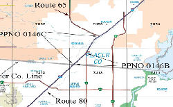 In September 2006, the CTC discussed the I-80
Capacity/Operational Improvements parent project (PPNO 0146D), which
includes the construction of eastbound and westbound HOV and auxiliary
lanes from the Sacramento/Placer County line (PM 0.0) to Route 65 (PM
5.1). The project scope also includes upgrading the traffic monitoring
system through the use of traffic sensors, closed circuit cameras, and
changeable message signs. The estimate for the total project is currently
$193,200,000. The proposal was to split the parent project into two phases
within available funding. Due to capital construction and right of way
funding constraints, it is not feasible to fund the entire project within
the time frame necessary to address the immediate needs. Phase I (PPNO
0146B), planned for construction this year, includes operational
improvements and an eastbound auxiliary lane from the
In September 2006, the CTC discussed the I-80
Capacity/Operational Improvements parent project (PPNO 0146D), which
includes the construction of eastbound and westbound HOV and auxiliary
lanes from the Sacramento/Placer County line (PM 0.0) to Route 65 (PM
5.1). The project scope also includes upgrading the traffic monitoring
system through the use of traffic sensors, closed circuit cameras, and
changeable message signs. The estimate for the total project is currently
$193,200,000. The proposal was to split the parent project into two phases
within available funding. Due to capital construction and right of way
funding constraints, it is not feasible to fund the entire project within
the time frame necessary to address the immediate needs. Phase I (PPNO
0146B), planned for construction this year, includes operational
improvements and an eastbound auxiliary lane from the Sacramento/Placer
County line Auburn Boulevard/Riverside onramp to the Douglas
Boulevard northbound offramp. Phase II (PPNO 0146C) of the
project, to start later (Spring 2008), includes eastbound and
westbound HOV lanes, auxiliary lanes, and Traffic Operation System
(TOS) elements from Auburn Boulevard/Riverside Avenue to just east
of the Route 65 interchange west of Miner’s Ravine.
The westbound direction other segment will be
funded at a later date.
 Business Routes
In September 2015, it was reported that Caltrans was resigning the
routes in Sacramento to de-emphasize Business Route 80 except where legislatively
mandated (i.e., along Route 51). This is based on a desire to simplify
things and just sign US 50 as one route and not a multitude of routes,
especially as more and more people are referring to the joint US 50/BR
80 multiplex as simply US 50. However, the legislative description for
Route 51 mandates that it be signed as Business Route 80; the legislative
description of Route 50 includes no such requirement. So basically, BR
80 is becoming a Business spur, but there's no plans to update the
signing to reflect such a change. The Capital City Freeway name will
be emphasized on Route 51 and only Route 51.
(Source: Joe Rouse @ AAroads, 9/25/2015)
Interstate SubmissionsApproved as chargeable Interstate on 7/7/1947, with a routing through Sacramento that followed what is now US 50 (the unsigned I-305 portion) to the Route 99/US 50 interchange, and then what is designated as Business 80 (Unsigned Route 51) north to the point where it rejoins I-80. The current routing of I-80 between the US 50/I-80 interchange and the Business Route 80 (Route 51)/I-80 interchange was originally designated at I-880 and was approved as chargeable interstate in July of 1958. I-305 was approved as chargeable interstate in May 1980; at the same time, the business route portion was removed from the interstate system. I-305 (US 50 between I-80 and Route 99) is currently signed as Business Route 80.
In August 1957, this was tentatively approved as I-80; however, in November 1957 the California Department of Highways suggested that it be designated as I-76 to eliminate confusion with the existing US 80 in California. This was rejected by AASHTO, as was probably one of the factors leading to the "great renumbering".
Naming The entire freeway between San Francisco and Nevada is named the "Dwight D. Eisenhower Highway".
Dwight Eisenhower was the 34th President of the United States,
and is believed to be the driving force behind the interstate system. He
died in 1969. For more information, see President Eisenhower's official biography or visit the Eisenhower Library. Named by the Federal Highway Administration in 1973.
The entire freeway between San Francisco and Nevada is named the "Dwight D. Eisenhower Highway".
Dwight Eisenhower was the 34th President of the United States,
and is believed to be the driving force behind the interstate system. He
died in 1969. For more information, see President Eisenhower's official biography or visit the Eisenhower Library. Named by the Federal Highway Administration in 1973.
(Image source: Wikipedia)
The entire route in California has been submitted to be part of the National Purple Heart Trail. The Military Order of the Purple Heart is working to establish a national commemorative trail for recipients of the Purple Heart medal, which honors veterans who were wounded in combat. All states in the union will designate highways for inclusion in the commemorative trail, and all of the designated highways will be interconnected to form the National Purple Heart Trail. Named by Senate Concurrent Resolution 14, Resolution Chapter 79, July 10, 2001.
The portion of part (2) of I-80 in San
Francisco (~ SF 5.567 to SF 5.932) is named the "James Lick Skyway".
James Lick (1796-1876) was a piano and organ maker from Pennsylvania who
financed the observatory atop Mt. Hamilton. He moved to San Francisco in
1848 and made his fortune in real estate. Named by Assembly Concurrent
Resolution 37, Chapt. 122 in 1951.
(Image source: Found SF)
 The bicycle-pedestrian path on the proposed new span of the San
Francisco-Oakland Bay Bridge (I-80) (~ SF R8.245 to ALA 1.134L) is named
the "Alexander Zuckermann Bicycle-Pedestrian Path". Named in honor
of Alexander Zuckermann, a member of the Metropolitan Transportation
Commission Advisory Council and a founder of the East Bay Bicycle
Coalition and a leader of the Regional Bicycle Advocacy Coalition, who was
a tireless and articulate advocate in the design process to replace the
east span of the San Francisco-Oakland Bay Bridge (collapsed by the 1989
Loma Priata Earthquake). The well-organized and persistent efforts of
Alexander Zuckermann were key factors in the final decision to include a
bicycle-pedestrian path on the southern edge of the eastbound deck of the
San Francisco-Oakland Bay Bridge between Yerba Buena Island and Oakland.
Named by Assembly Concurrent Resolution 39, Chaptered 7/11/2003, Chapter
94.
The bicycle-pedestrian path on the proposed new span of the San
Francisco-Oakland Bay Bridge (I-80) (~ SF R8.245 to ALA 1.134L) is named
the "Alexander Zuckermann Bicycle-Pedestrian Path". Named in honor
of Alexander Zuckermann, a member of the Metropolitan Transportation
Commission Advisory Council and a founder of the East Bay Bicycle
Coalition and a leader of the Regional Bicycle Advocacy Coalition, who was
a tireless and articulate advocate in the design process to replace the
east span of the San Francisco-Oakland Bay Bridge (collapsed by the 1989
Loma Priata Earthquake). The well-organized and persistent efforts of
Alexander Zuckermann were key factors in the final decision to include a
bicycle-pedestrian path on the southern edge of the eastbound deck of the
San Francisco-Oakland Bay Bridge between Yerba Buena Island and Oakland.
Named by Assembly Concurrent Resolution 39, Chaptered 7/11/2003, Chapter
94.
(Image sources: Komoot, SFGate)
 There is the possibility that the some or all of the Bay Bridge will also be named the Emperor Norton Bridge.
At the county level, where the San Francisco City/County Board of
Supervisors voted 8-2 in December 2004 to recommend the name change for
the Eastern Span. The resolution, after approval by then Mayor Gavin
Newsom, traveled to the Oakland City Council. However, Oakland laughed at
the idea, and the proposal was dead within two months. The drive to rename
the bridge was publicized by Chronicle cartoonist Phil Frank in his strip
"Farley". Norton, who occupied a 10-by-6-foot front room of the Eureka
Lodgings at 624 Commercial Street, would have been a present-day
constituent of Supervisor Aaron Peskin. And so it was Peskin who picked up
Frank's idea, molded it into a resolution and brought it to the Board of
Supervisors. There was also an online petition, which as of 2020 had more than 6,150 signatures, urging the Legislature to additionally name the entire Bay Bridge
system after Joshua Abraham Norton, the self-proclaimed Emperor
Norton I, who some credit with coming up with the idea for the bridge in
the 19th century. The naming would be in memory of Joshua
Abraham Norton–who hailed from Scotland, and was a businessman who
came to San Francisco by way of South Africa in 1849 to try his luck in
the Gold Rush. It is said that he lost his fortune–and his mental
stability–after making a bum investment in the rice market a few
years later. In 1859, he proclaimed himself Emperor of the United States
and, shortly thereafter, the Protector of Mexico. For the next 20 years,
he issued proclamations defending minorities and championing civil rights,
which were reproduced in local newspapers. He roamed the city accompanied
by his dogs, Bummer and Lazarus, and some eateries honored Norton's own
specially printed paper money. In 1872, Norton ordered "a bridge be built
from Oakland Point to Goat (Yerba Buena) Island and thence to Telegraph
Hill." Though his proclamation received little notice at the time, such a
bridge would open in 1936, described by President Herbert Hoover as "the
greatest bridge ever erected by the human race." Another of Norton's noted
proclamations decreed that "Whoever after due and proper warning shall be
heard to utter the abominable word 'Frisco,' which has no linguistic or
other warrant, shall be deemed guilty of a High Misdemeanor." The penalty:
$25. Note: At the same time as the official sign naming the bridge after
Willie Brown was dedicated, a group of unidentified artists installed a
large sign at the Bay Bridge onramp at Fifth Street, commemorating Joshua
A. Norton. Following Norton's protocol, the group of artists who installed
the Emperor Norton sign this week did just that: issued a proclamation.
"In 1872 Emperor Norton decreed this Bridge." Along the bottom of the sign
in small lettering, it reads: "A gift from the artists to the city of San
Francisco, Feb. 11 2014."
There is the possibility that the some or all of the Bay Bridge will also be named the Emperor Norton Bridge.
At the county level, where the San Francisco City/County Board of
Supervisors voted 8-2 in December 2004 to recommend the name change for
the Eastern Span. The resolution, after approval by then Mayor Gavin
Newsom, traveled to the Oakland City Council. However, Oakland laughed at
the idea, and the proposal was dead within two months. The drive to rename
the bridge was publicized by Chronicle cartoonist Phil Frank in his strip
"Farley". Norton, who occupied a 10-by-6-foot front room of the Eureka
Lodgings at 624 Commercial Street, would have been a present-day
constituent of Supervisor Aaron Peskin. And so it was Peskin who picked up
Frank's idea, molded it into a resolution and brought it to the Board of
Supervisors. There was also an online petition, which as of 2020 had more than 6,150 signatures, urging the Legislature to additionally name the entire Bay Bridge
system after Joshua Abraham Norton, the self-proclaimed Emperor
Norton I, who some credit with coming up with the idea for the bridge in
the 19th century. The naming would be in memory of Joshua
Abraham Norton–who hailed from Scotland, and was a businessman who
came to San Francisco by way of South Africa in 1849 to try his luck in
the Gold Rush. It is said that he lost his fortune–and his mental
stability–after making a bum investment in the rice market a few
years later. In 1859, he proclaimed himself Emperor of the United States
and, shortly thereafter, the Protector of Mexico. For the next 20 years,
he issued proclamations defending minorities and championing civil rights,
which were reproduced in local newspapers. He roamed the city accompanied
by his dogs, Bummer and Lazarus, and some eateries honored Norton's own
specially printed paper money. In 1872, Norton ordered "a bridge be built
from Oakland Point to Goat (Yerba Buena) Island and thence to Telegraph
Hill." Though his proclamation received little notice at the time, such a
bridge would open in 1936, described by President Herbert Hoover as "the
greatest bridge ever erected by the human race." Another of Norton's noted
proclamations decreed that "Whoever after due and proper warning shall be
heard to utter the abominable word 'Frisco,' which has no linguistic or
other warrant, shall be deemed guilty of a High Misdemeanor." The penalty:
$25. Note: At the same time as the official sign naming the bridge after
Willie Brown was dedicated, a group of unidentified artists installed a
large sign at the Bay Bridge onramp at Fifth Street, commemorating Joshua
A. Norton. Following Norton's protocol, the group of artists who installed
the Emperor Norton sign this week did just that: issued a proclamation.
"In 1872 Emperor Norton decreed this Bridge." Along the bottom of the sign
in small lettering, it reads: "A gift from the artists to the city of San
Francisco, Feb. 11 2014."
(Information on Emperor Norton from SFGate.Com, you can find more information at The Virtual Museum of the City of San Francisco. Image sources: Laughing Squid; History Channel)
The portion of I-80 from the San Francisco-Oakland Bay Bridge through Richmond (~ ALA 1.134L to CC 0.000) is named the "East Shore Freeway". This section of freeway was named by Senate Concurrent Resolution 99, Chapt. 229 in 1968. It was named because it runs along the east short of the bay. This was the original name before the Nimitz name came into use.
 The portion of I-80 from the San
Francisco-Oakland Bay Bridge through Alameda County to the Contra Costa
County Line (~ ALA 1.134L to CC 0.000) is named the "Kent D. Pursel
Memorial Freeway". Mr. Pursel was a Berkeley druggist and
councilman. He was a delegate to the Republican National Convention in
1948. He held a succession of elected offices until his death on August
15, 1967. This should not be confused with Charles Purcell who oversaw the
construction of the San Francisco-Oakland Bay Bridge. Named by Senate
Concurrent Resolution 99, Chapter 229 in 1968.
The portion of I-80 from the San
Francisco-Oakland Bay Bridge through Alameda County to the Contra Costa
County Line (~ ALA 1.134L to CC 0.000) is named the "Kent D. Pursel
Memorial Freeway". Mr. Pursel was a Berkeley druggist and
councilman. He was a delegate to the Republican National Convention in
1948. He held a succession of elected offices until his death on August
15, 1967. This should not be confused with Charles Purcell who oversaw the
construction of the San Francisco-Oakland Bay Bridge. Named by Senate
Concurrent Resolution 99, Chapter 229 in 1968.
(Image source: Calisphere)
 I-80 from Route 4 to the Carquinez Bridge in
Contra Costa County (~ CC 10.132 to CC 13.771) is named the "Linus
F. Claeys Freeway". Linus F. Claeys, a 1932 graduate of St.
Mary's College in Moraga, was a rancher, businessman, philanthropist and
descendant of California pioneers whose land SR 80 traverses. Two
residence halls at St. Mary's College bear his name. Named by Senate
Concurrent Resolution 85, Chapter 80 in 1990.
I-80 from Route 4 to the Carquinez Bridge in
Contra Costa County (~ CC 10.132 to CC 13.771) is named the "Linus
F. Claeys Freeway". Linus F. Claeys, a 1932 graduate of St.
Mary's College in Moraga, was a rancher, businessman, philanthropist and
descendant of California pioneers whose land SR 80 traverses. Two
residence halls at St. Mary's College bear his name. Named by Senate
Concurrent Resolution 85, Chapter 80 in 1990.
(Image source: St. Marys College)
 The portion of I-80 that passes
through Vallejo, from the Carquinez Bridge to Columbus Parkway (~ SOL
0.036 to SOL 5.598), is named the "Jeffrey Lynn Azuar Memorial Highway".
Jeffrey Lynn Azuar was a Vallejo Police Officer who was killed in the line
of duty on April 12, 2000. He was born and raised in Vallejo and served
the community as an officer with the Vallejo Police Department for over 21
years, serving as a patrol officer, a narcotics officer, a member of the
SWAT team, a member of the Honor Guard, and a K-9 officer. Named by Senate
Concurrent Resolution 85, Chapter 155, on September 20, 2000.
The portion of I-80 that passes
through Vallejo, from the Carquinez Bridge to Columbus Parkway (~ SOL
0.036 to SOL 5.598), is named the "Jeffrey Lynn Azuar Memorial Highway".
Jeffrey Lynn Azuar was a Vallejo Police Officer who was killed in the line
of duty on April 12, 2000. He was born and raised in Vallejo and served
the community as an officer with the Vallejo Police Department for over 21
years, serving as a patrol officer, a narcotics officer, a member of the
SWAT team, a member of the Honor Guard, and a K-9 officer. Named by Senate
Concurrent Resolution 85, Chapter 155, on September 20, 2000.
(Image source: Officer Down Memorial Page)
The interchange of I-80 and I-780 in the City of Vallejo in the County of Solano (~ 80 SOL 2.105/SOL 2.416; 780 SOL 7.071/SOL 7.429) is named the “Congressional Gold Medal Memorial Interchange”. It was named to honor the fact that the City of Vallejo is the home of the former Mare Island Naval Shipyard and has a large concentration of veterans who have served honorably in the Armed Forces of the United States. Many of these service members are being honored by the United States government for their actions in various theaters of war and conflict, as well as for their distinguished peacetime achievements. The Congressional Gold Medal is the United States Congress’ highest expression of national appreciation for distinguished achievements and contributions that may be awarded to recognize individuals, groups, or institutions. The interchange specifically honors all the Congressional Gold Medal recipients from General George Washington to the African American “Hidden Figures” NASA mathematicians and engineers, and various other warriors, including the Native American Code Talkers, Tuskegee Airmen, Women Airforce Service Pilots of World War II, Japanese American 100th Infantry Battalion and 442nd Regimental Combat Team, Montford Point Marines, Hispanic 65th Infantry Regiment, Filipino veterans of World War II, and the Chinese American veterans of World War II. Named by Senate Resolution SCR 111, Res. Chapter 179, 09/13/22.
 The eastbound I-80/Route 37
interchange (~ SOL 5.598) is named the "Gary L. Hughes Memorial
Interchange". Officer Gary L. Hughes and his partner Officer Lancer
R. Thelen stopped and arrested a suspected drunk driver along Interstate 80 in Vallejo. Hughes was sitting in the rear of the patrol car with the
suspect when a pick-up truck camper plowed into the patrol car pinning
Hughes against the front seat and causing massive head injuries. The
38-year-old Patrol officer died enroute to the hospital and the prisoner
received minor injuries. Thelen was near the front of the patrol car with
a tow truck operator completing paperwork for impounding the suspect's
vehicle when they were struck by the patrol car as it was rammed by the
truck camper. Thelen suffered a severe leg injury and the tow truck
operator had a compound leg fracture. The driver of the truck camper was
taken into custody on charges of felony drunk driving and manslaughter.
Hughes was an 11-year veteran of the Patrol. Named by Assembly Concurrent
Resolution 100, Chapter 124, in 1998.
The eastbound I-80/Route 37
interchange (~ SOL 5.598) is named the "Gary L. Hughes Memorial
Interchange". Officer Gary L. Hughes and his partner Officer Lancer
R. Thelen stopped and arrested a suspected drunk driver along Interstate 80 in Vallejo. Hughes was sitting in the rear of the patrol car with the
suspect when a pick-up truck camper plowed into the patrol car pinning
Hughes against the front seat and causing massive head injuries. The
38-year-old Patrol officer died enroute to the hospital and the prisoner
received minor injuries. Thelen was near the front of the patrol car with
a tow truck operator completing paperwork for impounding the suspect's
vehicle when they were struck by the patrol car as it was rammed by the
truck camper. Thelen suffered a severe leg injury and the tow truck
operator had a compound leg fracture. The driver of the truck camper was
taken into custody on charges of felony drunk driving and manslaughter.
Hughes was an 11-year veteran of the Patrol. Named by Assembly Concurrent
Resolution 100, Chapter 124, in 1998.
(Image source: California Association of Highway Patrolmen)
 The portion of I-80 between the Route 12 interchange and Midway Road in the County of
Solano (~ SOL 15.863 to SOL 32.651) as the Tuskegee Airmen Memorial
Highway to honor the Tuskegee Airmen and the contributions they
made during World War II. Named by Senate Concurrent Resolution 45, August
29, 2013. Resolution Chapter 92.
The portion of I-80 between the Route 12 interchange and Midway Road in the County of
Solano (~ SOL 15.863 to SOL 32.651) as the Tuskegee Airmen Memorial
Highway to honor the Tuskegee Airmen and the contributions they
made during World War II. Named by Senate Concurrent Resolution 45, August
29, 2013. Resolution Chapter 92.
(Image source: The Reporter, ABC 4 South Carolina)
 The interchange of I-80 and I-505 in the County of Solano (~ SOL R28.249) is
named the "Lieutenant Colonel James C. Warren Memorial Interchange".
It
was named in memory of Lieutenant Colonel James C. Warren, who was born in
August 1923 into the racially segregated community of Gurly,
Alabama.Warren left the region at the age of 15 years, when his mother
sent him to Island Park, Illinois, where he attended high school.
Enlisting in 1943 to preflight with the Tuskegee Airmen, the all black
United States Army Air Force unit that distinguished itself in combat
during World War II, Lieutenant Colonel Warren was assigned to
Indiana’s Freeman Field, where, after being eliminated from pilot
training, he completed navigator training, through which he qualified as
both a navigator and a bombardier. Lieutenant Colonel Warren was one of
the 101 black officers at Freeman Field in 1945 who were arrested and
charged with mutiny because they refused to comply with base regulations
excluding black officers from a base officers’ club. The service
records of Lieutenant Colonel Warren and the other 100 officers were
cleared by the Air Force in 1995, an action that was announced that year
during a convention of the Tuskegee Airmen. After serving with the 477th
Bombardment Group of the Tuskegee Airmen, Lieutenant Colonel Warren spent
35 years with the United States Air Force, for which he flew 173 combat
missions in Korea and Vietnam, earning such esteemed commendations and
decorations as the Congressional Gold Medal, Distinguished Flying Cross
with two Oak Leaf Clusters, and Air Force Commendation Medal, among
numerous others. A University of Nebraska graduate who ultimately became
the oldest individual to earn a pilot’s license at the age of 87
years, Lieutenant Colonel Warren distinguished himself through his
community leadership and participation in the Nut Tree Airport’s
Young Eagles program, as well as his membership with the Jimmy Doolittle
Air and Space Museum Foundation, the Kappa Alpha Psi Fraternity, and
Tuskegee Airmen Incorporated. Named by Senate Concurrent Resolution (SCR)
24, Res. Chapter 108, Statutes of 2015, on July 16, 2015.
The interchange of I-80 and I-505 in the County of Solano (~ SOL R28.249) is
named the "Lieutenant Colonel James C. Warren Memorial Interchange".
It
was named in memory of Lieutenant Colonel James C. Warren, who was born in
August 1923 into the racially segregated community of Gurly,
Alabama.Warren left the region at the age of 15 years, when his mother
sent him to Island Park, Illinois, where he attended high school.
Enlisting in 1943 to preflight with the Tuskegee Airmen, the all black
United States Army Air Force unit that distinguished itself in combat
during World War II, Lieutenant Colonel Warren was assigned to
Indiana’s Freeman Field, where, after being eliminated from pilot
training, he completed navigator training, through which he qualified as
both a navigator and a bombardier. Lieutenant Colonel Warren was one of
the 101 black officers at Freeman Field in 1945 who were arrested and
charged with mutiny because they refused to comply with base regulations
excluding black officers from a base officers’ club. The service
records of Lieutenant Colonel Warren and the other 100 officers were
cleared by the Air Force in 1995, an action that was announced that year
during a convention of the Tuskegee Airmen. After serving with the 477th
Bombardment Group of the Tuskegee Airmen, Lieutenant Colonel Warren spent
35 years with the United States Air Force, for which he flew 173 combat
missions in Korea and Vietnam, earning such esteemed commendations and
decorations as the Congressional Gold Medal, Distinguished Flying Cross
with two Oak Leaf Clusters, and Air Force Commendation Medal, among
numerous others. A University of Nebraska graduate who ultimately became
the oldest individual to earn a pilot’s license at the age of 87
years, Lieutenant Colonel Warren distinguished himself through his
community leadership and participation in the Nut Tree Airport’s
Young Eagles program, as well as his membership with the Jimmy Doolittle
Air and Space Museum Foundation, the Kappa Alpha Psi Fraternity, and
Tuskegee Airmen Incorporated. Named by Senate Concurrent Resolution (SCR)
24, Res. Chapter 108, Statutes of 2015, on July 16, 2015.
(Image source: Solano Daily Republic)
 Casselman Memorial Highway") The portion of I-80 between the Solano County
line (~YOL 0.00) and County Road 32A (~ YOL 5.781) in the County of Yolo
is named the "CHP Officer William “Ivan” Casselman Memorial
Highway". It was named in memory of Officer William
“Ivan” Casselman, who was born in 1902 to Anson and Lucy in
Ontario, Canada. Officer “Ivan” Casselman, was killed in the
line of duty on August 24, 1935, when his motorcycle struck the back of a
truck. Officer Casselman was well liked and respected in the community. He
was admired for his integrity and approachability. It was named in
recognition of Officer Casselman’s contributions and sacrifice in
serving the CHP and the citizens of California.Named by Assembly
Concurrent Resolution 100, Resolution Chapter 109, on September 4, 2012.
The portion of I-80 between the Solano County
line (~YOL 0.00) and County Road 32A (~ YOL 5.781) in the County of Yolo
is named the "CHP Officer William “Ivan” Casselman Memorial
Highway". It was named in memory of Officer William
“Ivan” Casselman, who was born in 1902 to Anson and Lucy in
Ontario, Canada. Officer “Ivan” Casselman, was killed in the
line of duty on August 24, 1935, when his motorcycle struck the back of a
truck. Officer Casselman was well liked and respected in the community. He
was admired for his integrity and approachability. It was named in
recognition of Officer Casselman’s contributions and sacrifice in
serving the CHP and the citizens of California.Named by Assembly
Concurrent Resolution 100, Resolution Chapter 109, on September 4, 2012.
(Image source: Facebook, Yolo County Retired Police Officers Association)
The portion of I-80 W of the intersection with Route 51 (signed as Business 80) in Sacramento (~ YOL R10.163 to SAC R10.891) is named the "West Sacramento Freeway". It was named after the city of West Sacramento. This city originally known as "East Yolo" in the early parts of the 20th century, later developed into three or four seperate communities: Bryte and Broderick, accessed by former Route 16/Route 84; West Sacramento, on West Capitol Avenue, and Southport, which developed when the Port of Sacramento was built in the 1950s. These communities merged to form an independent city in 1987. Sacramento refers to the City of Sacramento CA, which is based off of the name of the main river in the city. The Spanish name, "Holy Sacrament," was applied to the Feather River in 1808; it was later assumed that the lower Sacramento was the same stream. In 1817 the two main rivers of the valley were recorded as Sacramento and San Joaquin rivers, but the course of the former was not identified with the name until the 1830s. The city was laid out in 1848-1849 and named after the river by John A. Sutter, Jr., and Sam Brannan. The county, one of the original 27, was named in 1850.
The portion of this route from Sacramento to Route 65 (~ SAC M0.222 to PLA 4.017) was historically called the "Capitol Highway". Capitol refers to the fact that Sacramento is the Capital of California, and the Capitol is located there.
 The portion of I-80
from the Antelope Road Overcrossing Bridge № 24-0129 (PM SAC 16.68)
in the County of Sacramento to the Douglas Boulevard Overcrossing Bridge
№ 19-0079 (PM PLA 1.98) in the County of Placer is named the “CHP
Officer Lucas F. Chellew Memorial Highway”. It was named
after Lucas F. Chellew, who was born in August 1985, in Berkeley,
California. Lucas grew up in Grass Valley, California. After graduating in
2003 from Bear River High School in Grass Valley, Lucas started his life
of service at 18 years of age, enlisting in the United States Army,
proudly serving his country for five years of active duty and three years
in the Army Reserve, including deployments to the Netherlands,
Afghanistan, and Germany, as Military Police, and earning the rank of
Sergeant E-5 before his discharge. On November 10, 2008, Lucas entered the
California Highway Patrol Academy; and graduated from the California
Highway Patrol Academy on May 15, 2009, and then worked in the West Valley
office and began his career as a motorcycle officer. Officer Chellew
transferred to the Capitol Protection Section in Sacramento and
transitioned from a motorcycle officer to an equestrian officer partnered
with his horse, Samson, and then settled in the South Sacramento office in
July 2015, where he worked for two years, returning to motorcycle duty. On
February 22, 2017, Officer Chellew was in pursuit of a stolen motorcycle
on Fruitridge Road in Sacramento and was involved in a fatal collision.
Named by Senate Resolution SCR 117, Res. Chapter 180, 09/13/22.
The portion of I-80
from the Antelope Road Overcrossing Bridge № 24-0129 (PM SAC 16.68)
in the County of Sacramento to the Douglas Boulevard Overcrossing Bridge
№ 19-0079 (PM PLA 1.98) in the County of Placer is named the “CHP
Officer Lucas F. Chellew Memorial Highway”. It was named
after Lucas F. Chellew, who was born in August 1985, in Berkeley,
California. Lucas grew up in Grass Valley, California. After graduating in
2003 from Bear River High School in Grass Valley, Lucas started his life
of service at 18 years of age, enlisting in the United States Army,
proudly serving his country for five years of active duty and three years
in the Army Reserve, including deployments to the Netherlands,
Afghanistan, and Germany, as Military Police, and earning the rank of
Sergeant E-5 before his discharge. On November 10, 2008, Lucas entered the
California Highway Patrol Academy; and graduated from the California
Highway Patrol Academy on May 15, 2009, and then worked in the West Valley
office and began his career as a motorcycle officer. Officer Chellew
transferred to the Capitol Protection Section in Sacramento and
transitioned from a motorcycle officer to an equestrian officer partnered
with his horse, Samson, and then settled in the South Sacramento office in
July 2015, where he worked for two years, returning to motorcycle duty. On
February 22, 2017, Officer Chellew was in pursuit of a stolen motorcycle
on Fruitridge Road in Sacramento and was involved in a fatal collision.
Named by Senate Resolution SCR 117, Res. Chapter 180, 09/13/22.
(Image source: CHP 11-99 Foundation)
 The portion of I-80 between the Sacramento county line and the Nevada border
(~ PLA 0.000 and SIE 1.356) is officially named the "Alan S. Hart
Freeway". During his 42 years of service as an engineer for
Caltrans, Alan S. Hart accomplished the modernization of the Trans Sierra
Highway (I-80 over Donner Summit) and the adoption of 50 miles of freeway
on US 101 through the redwoods of Humboldt County. Named by Senate
Concurrent Resolution No. 102, Chapter 164, in 1986.
The portion of I-80 between the Sacramento county line and the Nevada border
(~ PLA 0.000 and SIE 1.356) is officially named the "Alan S. Hart
Freeway". During his 42 years of service as an engineer for
Caltrans, Alan S. Hart accomplished the modernization of the Trans Sierra
Highway (I-80 over Donner Summit) and the adoption of 50 miles of freeway
on US 101 through the redwoods of Humboldt County. Named by Senate
Concurrent Resolution No. 102, Chapter 164, in 1986.
(Image source: Email from Nathaniel B)
 The Rocklin Road interchange on I-80 in Placer County (~ PLA 6.027) is named the "CHP
Officer Raymond Carpenter Memorial Interchange" This interchange was
named in memory of Raymond Roy Carpenter, born on July 15, 1929, in the
Wolf area of Placer County, between Auburn and Grass Valley. He was born
in a small cabin with no inside plumbing and no electricity. The Carpenter
family moved shortly after his birth to the Sullivan Ranch in Auburn,
where Ray's father was the foreman. Ray learned the ways of a ranch hand,
working with cattle, sheep, and the many different orchards at the ranch.
In 1943 the family moved again to 831 Old Route 5 (now Dairy Road) in
Auburn, a house which Ray later owned and which is owned and resided in by
Ray's sister Pearl Burkett. Ray attended Placer High School and that is
where his interest in the military began. He was a member of the Junior
Reserve Officer Training Corps (JROTC). Ray graduated from Placer High and
immediately joined the United States Air Force, serving as an enlisted man
specializing in weather forecast and analysis. He was stationed in Chanute
Air Force Base in Illinois, later in Virginia during which he changed his
career field to security police. His last post was Elmendorf Air Force
Base in Alaska. Alaska was a territory and not a state at the time, and
Ray had the opportunity to be a homesteader, which meant that he
homesteaded a piece of property, building a cabin with his own hands and
living in it. Ray was an avid hunter and fisherman, so this suited his
lifestyle perfectly. Ray served during the Korean War, and his service
qualified him for membership in the Veterans of Foreign Wars (VFW)
organization. Ray was honorably discharged from the United States Air
Force as a Technical Sergeant. Ray joined the Department of the California
Highway Patrol (CHP) soon after his discharge from the United States Air
Force. He was initially assigned to Bakersfield. He transferred to the
Truckee area office and finally made his way to the Auburn office. Ray was
soon back at home in the Auburn area patrolling the roads in his hometown.
His widow Pat said that law enforcement and the CHP suited Ray perfectly,
due to his great respect for authority. Ray's friend and coworker, retired
officer Jim Mayhorn, relates that he and Ray were also very active in the
early days of the Civil Air Patrol Squadron 60 in Auburn. Jim said that
Ray was an aircraft observer and would often go up and assist with search
and rescue missions in the area. Other than his seven-year service in the
United States Air Force and the beginning of his CHP career, Ray lived in
the Auburn area his whole life. In the early 1960s, Ray ran for the State
Senate seat for the district that covers Auburn, and narrowly lost in his
bid against the incumbent, Ron Cameron. Ray is described by all who knew
him as the kind of guy who would look to help another out. When he came
across someone less fortunate and in need, he would easily provide the
person a ride, or a burger at the local burger place, or even take the
person home for a couple of days to get the person back on his or her
feet. His wife Pat tells the story of Ray and Ken Lawton. Ray pulled Ken
over one Saturday morning for extremely high speed on eastbound I-80. The
young United States Navy sailor explained, after a short pursuit and being
handcuffed at gunpoint, that he was on a weekend pass and was attempting
to go home to Provo, Utah. Ray explained that even if Ken didn't splatter
himself and his motorcycle all over the Nevada desert and made it all the
way home, he would only have 20 minutes with his family and have to turn
around and come back. Ray convinced Ken to stay. He let Ken sleep on the
couch at his house, and took him on a ride along with the patrol the next
day. They became fast friends. Ray was an inspiration to Ken and after his
tour with the United States Navy was over, Ken joined the Utah Highway
Patrol (UHP). Ken retired as a captain with the UHP a few years ago, and
he recounts that one of his prize possessions is Ray's service revolver,
presented to him by Pat after Ray's death. On February 17, 1970, Ray
Carpenter, a California Highway Patrol officer and loyal servant to the
State of California, died after being shot by the driver of a vehicle he
had stopped. Named by Senate Concurrent Resolution (SCR) 50, Resolution
Chapter 64, on 8/4/2010.
The Rocklin Road interchange on I-80 in Placer County (~ PLA 6.027) is named the "CHP
Officer Raymond Carpenter Memorial Interchange" This interchange was
named in memory of Raymond Roy Carpenter, born on July 15, 1929, in the
Wolf area of Placer County, between Auburn and Grass Valley. He was born
in a small cabin with no inside plumbing and no electricity. The Carpenter
family moved shortly after his birth to the Sullivan Ranch in Auburn,
where Ray's father was the foreman. Ray learned the ways of a ranch hand,
working with cattle, sheep, and the many different orchards at the ranch.
In 1943 the family moved again to 831 Old Route 5 (now Dairy Road) in
Auburn, a house which Ray later owned and which is owned and resided in by
Ray's sister Pearl Burkett. Ray attended Placer High School and that is
where his interest in the military began. He was a member of the Junior
Reserve Officer Training Corps (JROTC). Ray graduated from Placer High and
immediately joined the United States Air Force, serving as an enlisted man
specializing in weather forecast and analysis. He was stationed in Chanute
Air Force Base in Illinois, later in Virginia during which he changed his
career field to security police. His last post was Elmendorf Air Force
Base in Alaska. Alaska was a territory and not a state at the time, and
Ray had the opportunity to be a homesteader, which meant that he
homesteaded a piece of property, building a cabin with his own hands and
living in it. Ray was an avid hunter and fisherman, so this suited his
lifestyle perfectly. Ray served during the Korean War, and his service
qualified him for membership in the Veterans of Foreign Wars (VFW)
organization. Ray was honorably discharged from the United States Air
Force as a Technical Sergeant. Ray joined the Department of the California
Highway Patrol (CHP) soon after his discharge from the United States Air
Force. He was initially assigned to Bakersfield. He transferred to the
Truckee area office and finally made his way to the Auburn office. Ray was
soon back at home in the Auburn area patrolling the roads in his hometown.
His widow Pat said that law enforcement and the CHP suited Ray perfectly,
due to his great respect for authority. Ray's friend and coworker, retired
officer Jim Mayhorn, relates that he and Ray were also very active in the
early days of the Civil Air Patrol Squadron 60 in Auburn. Jim said that
Ray was an aircraft observer and would often go up and assist with search
and rescue missions in the area. Other than his seven-year service in the
United States Air Force and the beginning of his CHP career, Ray lived in
the Auburn area his whole life. In the early 1960s, Ray ran for the State
Senate seat for the district that covers Auburn, and narrowly lost in his
bid against the incumbent, Ron Cameron. Ray is described by all who knew
him as the kind of guy who would look to help another out. When he came
across someone less fortunate and in need, he would easily provide the
person a ride, or a burger at the local burger place, or even take the
person home for a couple of days to get the person back on his or her
feet. His wife Pat tells the story of Ray and Ken Lawton. Ray pulled Ken
over one Saturday morning for extremely high speed on eastbound I-80. The
young United States Navy sailor explained, after a short pursuit and being
handcuffed at gunpoint, that he was on a weekend pass and was attempting
to go home to Provo, Utah. Ray explained that even if Ken didn't splatter
himself and his motorcycle all over the Nevada desert and made it all the
way home, he would only have 20 minutes with his family and have to turn
around and come back. Ray convinced Ken to stay. He let Ken sleep on the
couch at his house, and took him on a ride along with the patrol the next
day. They became fast friends. Ray was an inspiration to Ken and after his
tour with the United States Navy was over, Ken joined the Utah Highway
Patrol (UHP). Ken retired as a captain with the UHP a few years ago, and
he recounts that one of his prize possessions is Ray's service revolver,
presented to him by Pat after Ray's death. On February 17, 1970, Ray
Carpenter, a California Highway Patrol officer and loyal servant to the
State of California, died after being shot by the driver of a vehicle he
had stopped. Named by Senate Concurrent Resolution (SCR) 50, Resolution
Chapter 64, on 8/4/2010.
(Image source: Facebook, Facebook)
The portion of this route that is former US 99E is, in local usage, called the "East Side Highway" (Route 51 (former I-80), as well as ~ 080 SAC R11.109 to 080 PLA 4.065) . This is because the US 99 routing ran along the east side of the valley.
 The Horseshoe Bar Road Interchange on I-80 in Placer County (~ PLA 8.717) is
named the "Detective Michael D. Davis, Jr. Memorial Highway". It
was named in memory of Michael David Davis, Jr., born in Bellflower,
California in October 1971. He moved to Placer County in 1995 to pursue a
career in law enforcement. He was initially hired by the Auburn Police
Department and joined the Placer County Sheriff’s Office in 1999 as
a patrol deputy. A Roseville resident, Deputy Sheriff Davis coached
baseball in the Woodcreek Little League for many years. Family and police
work were “where his heart was,” said Placer County Sheriff Ed
Bonner. Deputy Sheriff Davis’ brother Jason, his wife Jessica, and
aunt and uncle worked for the department. Deputy Sheriff Davis was a model
officer who had zero complaints from the public on his record and was
known for his respect, tact, and empathy toward those he served. Off-duty,
Deputy Sheriff Davis was the one who made everyone laugh at family
gatherings. He had great stories, a quick wit, and no filter, according to
his brother Jason. Deputy Sheriff Davis served his community with
everything that he had. He was a loving husband and father who adored all
of his children. As a coach he mentored other children. Deputy Sheriff
Davis was just five days short of his 17th birthday when his
father, for whom he was named, was killed while on assignment with the
Riverside County Sheriff’s Department. Deputy Sheriff Davis had two
younger brothers, Jason and Christopher. According to Jason, Michael
instantly assumed a parental role as a big brother and helped raise his
two younger brothers. When the younger boys were troubled or woke from
nightmares, they went to Michael’s room for comfort. Michael taught
them to play baseball, and he always included his two younger brothers in
his group of older friends. Deputy Sheriff Davis was always coaching and
inspiring those around him to be better. Deputy Sheriff Davis, who was on
assignment as an acting detective, was gunned down in the City of Auburn
at 42 years of age, on October 24, 2014, 26 years to the day after his
father perished in a helicopter crash during a police mission in southern
California. The shooting rampage that claimed Deputy Sheriff Davis’
life began in a Motel 6 parking lot in Sacramento and also killed
Sacramento County Sheriff’s Deputy Danny Oliver. Authorities have
charged Luis Enrique Monroy-Bracamonte and his wife, Janelle Marquez
Monroy, with the murder of a peace officer. When he died, Deputy Sheriff
Davis was on assignment as a homicide detective in the Crimes Against
Persons unit. Named by Senate Concurrent Resolution 151, Res. Chapter 183,
9/9/2016.
The Horseshoe Bar Road Interchange on I-80 in Placer County (~ PLA 8.717) is
named the "Detective Michael D. Davis, Jr. Memorial Highway". It
was named in memory of Michael David Davis, Jr., born in Bellflower,
California in October 1971. He moved to Placer County in 1995 to pursue a
career in law enforcement. He was initially hired by the Auburn Police
Department and joined the Placer County Sheriff’s Office in 1999 as
a patrol deputy. A Roseville resident, Deputy Sheriff Davis coached
baseball in the Woodcreek Little League for many years. Family and police
work were “where his heart was,” said Placer County Sheriff Ed
Bonner. Deputy Sheriff Davis’ brother Jason, his wife Jessica, and
aunt and uncle worked for the department. Deputy Sheriff Davis was a model
officer who had zero complaints from the public on his record and was
known for his respect, tact, and empathy toward those he served. Off-duty,
Deputy Sheriff Davis was the one who made everyone laugh at family
gatherings. He had great stories, a quick wit, and no filter, according to
his brother Jason. Deputy Sheriff Davis served his community with
everything that he had. He was a loving husband and father who adored all
of his children. As a coach he mentored other children. Deputy Sheriff
Davis was just five days short of his 17th birthday when his
father, for whom he was named, was killed while on assignment with the
Riverside County Sheriff’s Department. Deputy Sheriff Davis had two
younger brothers, Jason and Christopher. According to Jason, Michael
instantly assumed a parental role as a big brother and helped raise his
two younger brothers. When the younger boys were troubled or woke from
nightmares, they went to Michael’s room for comfort. Michael taught
them to play baseball, and he always included his two younger brothers in
his group of older friends. Deputy Sheriff Davis was always coaching and
inspiring those around him to be better. Deputy Sheriff Davis, who was on
assignment as an acting detective, was gunned down in the City of Auburn
at 42 years of age, on October 24, 2014, 26 years to the day after his
father perished in a helicopter crash during a police mission in southern
California. The shooting rampage that claimed Deputy Sheriff Davis’
life began in a Motel 6 parking lot in Sacramento and also killed
Sacramento County Sheriff’s Deputy Danny Oliver. Authorities have
charged Luis Enrique Monroy-Bracamonte and his wife, Janelle Marquez
Monroy, with the murder of a peace officer. When he died, Deputy Sheriff
Davis was on assignment as a homicide detective in the Crimes Against
Persons unit. Named by Senate Concurrent Resolution 151, Res. Chapter 183,
9/9/2016.
(Image Source: Officer Down Memorial Page)
 The portion of I-80 from Emigrant Gap to Donner Lake (~ PLA R55.28 to NEV
R12.538) was originally named the "Dutch Flat-Donner Lake Wagon Road".
This name was specified by Resolution Chapter 224 in 1909. It was named by
location.
The portion of I-80 from Emigrant Gap to Donner Lake (~ PLA R55.28 to NEV
R12.538) was originally named the "Dutch Flat-Donner Lake Wagon Road".
This name was specified by Resolution Chapter 224 in 1909. It was named by
location.
(Image source: Donner Summit Historical Society)
 Named Structures
 Rolph Bridge") Bridge 34-003 over San Francisco Bay (~ SF 006.35L) is called the "San Francisco-Oakland Bay Bridge", although
it was never formally named. It was opened in 1936. The San
Francisco-Oakland Bay Bridge is dedicated as a lasting memorial to the
memory of "James "Sunny Jim" Rolph". James Rolph was mayor of San Francisco for 19 years from 1911 to 1931. He was elected Governor of
California in 1931 and served until his death in 1934. The bridge wasn't
dedicated to Rolph until 1986 because of a rivalry with Oakland Tribune
publisher Joseph Knowland. Called "Sunny Jim" for his disposition, the
former shipyard owner was known for his generosity and his success with
projects such as building San Francisco's city hall in 1915 and promoting
expansion of the Municipal Railway.
Bridge 34-003 over San Francisco Bay (~ SF 006.35L) is called the "San Francisco-Oakland Bay Bridge", although
it was never formally named. It was opened in 1936. The San
Francisco-Oakland Bay Bridge is dedicated as a lasting memorial to the
memory of "James "Sunny Jim" Rolph". James Rolph was mayor of San Francisco for 19 years from 1911 to 1931. He was elected Governor of
California in 1931 and served until his death in 1934. The bridge wasn't
dedicated to Rolph until 1986 because of a rivalry with Oakland Tribune
publisher Joseph Knowland. Called "Sunny Jim" for his disposition, the
former shipyard owner was known for his generosity and his success with
projects such as building San Francisco's city hall in 1915 and promoting
expansion of the Municipal Railway.
(Image source: SF Curbed, Public Art and Architecture, Wikipedia)
 The new western span of the San Francisco-Oakland Bay Bridge (~SF 006.35) is officially named the "Willie L. Brown, Jr. Bridge."
It was named on 09/27/13 by ACR 65, Res. Chapter 140, Statutes of 2013.
Although the Governor could not veto the resolution, the governor -- who
says he has nothing against Willie Brown -- hopes Bay Area residents will
continue to refer to the span as simply the Bay Bridge. Critics say it's
not fitting to name the two-mile-long span, which opened in 1936 and was
retrofitted in 2004, after a politician they say shares the blame for the
delays and problems on the eastern half of the bridge. They note that
Brown played a key role in planning the Oakland side of the span, which
opened in September 2013 -- 24 years after a section of the roadway
collapsed in the Loma Prieta earthquake -- after its cost skyrocketed
five-fold, during a decade of planning, to $6.4 billion. But supporters,
led by the NAACP, say decades of work by Brown -- an African-American --
merit the honor. Legislative staffers have dutifully pointed out to
lawmakers that the plan violates four of the Legislature's own seven
policy requirements for naming a span after somebody, including the fact
that Brown is not dead. But the guideline that has proven most difficult
for supporters to deal with is the lack of a "community consensus" for the
new name. Even the San Francisco Chronicle, for which Brown writes a
column, editorialized against the plan. But, in the end, the segment was
named after Willie L. Brown, Jr., who was born in March 1934, in Mineola,
Texas. Mr. Brown received a bachelor of arts degree from San Francisco
State University in 1955 and a juris doctor from the University of
California, Hastings College of Law, in 1958. He was admitted to the
practice of law in the State of California and to the federal court,
including the United States Supreme Court. Mr. Brown was first elected in
1964 and served in all of the following capacities: as a Member of the
California State Assembly from 1965 to 1995, as Speaker of the California
State Assembly as the longest serving Speaker in California history, from
1980 to 1995, and the first African American; and two terms as the 41st
Mayor of the City and County of San Francisco, from January 8, 1996, to
January 8, 2004. Mr. Brown served as the Chair of the Assembly Ways and
Means Committee and the Chair of the Assembly Revenue and Taxation
Committee; served on the Board of Trustees of the California State
University system and as a Regent of the University of California; and
served on the Board of Administration of the California Public
Employees’ Retirement System. As mayor of California’s most
cosmopolitan city, he refurbished and rebuilt one of the nation’s
busiest transit systems, pioneered the use of bond measures to build
affordable housing, created a model juvenile justice system, and paved the
way for creating the expansion campus of the University of California, San
Francisco, to serve as the anchor of a new development that would position
the city as a center for the burgeoning field of biotechnology. The naming
resolution notes that Mr. Brown is widely regarded as one of the most
influential politicians of the late 20th century, and has been at the
center of California politics, government, and civic life for an
astonishing four decades. Mr. Brown’s career spans the American
presidency from Lyndon Johnson to Barack Obama, and he has worked with
every California Governor from Edmund Gerald “Pat” Brown, Sr.,
to Edmund Gerald “Jerry” Brown, Jr., and has left his
imprimatur on every aspect of politics and public policy in the Golden
State, including civil rights, education reform, tax policy, economic
development, health care, international trade, domestic partnerships, and
affirmative action. As of 2013, Mr. Brown headed the Willie L. Brown, Jr.
Institute on Politics and Public Service, where he shares his vast
political knowledge and skills with a new generation of California
leaders. Note: the naming resolution requires that the signs be funded by
donations from nonstate sources.
The new western span of the San Francisco-Oakland Bay Bridge (~SF 006.35) is officially named the "Willie L. Brown, Jr. Bridge."
It was named on 09/27/13 by ACR 65, Res. Chapter 140, Statutes of 2013.
Although the Governor could not veto the resolution, the governor -- who
says he has nothing against Willie Brown -- hopes Bay Area residents will
continue to refer to the span as simply the Bay Bridge. Critics say it's
not fitting to name the two-mile-long span, which opened in 1936 and was
retrofitted in 2004, after a politician they say shares the blame for the
delays and problems on the eastern half of the bridge. They note that
Brown played a key role in planning the Oakland side of the span, which
opened in September 2013 -- 24 years after a section of the roadway
collapsed in the Loma Prieta earthquake -- after its cost skyrocketed
five-fold, during a decade of planning, to $6.4 billion. But supporters,
led by the NAACP, say decades of work by Brown -- an African-American --
merit the honor. Legislative staffers have dutifully pointed out to
lawmakers that the plan violates four of the Legislature's own seven
policy requirements for naming a span after somebody, including the fact
that Brown is not dead. But the guideline that has proven most difficult
for supporters to deal with is the lack of a "community consensus" for the
new name. Even the San Francisco Chronicle, for which Brown writes a
column, editorialized against the plan. But, in the end, the segment was
named after Willie L. Brown, Jr., who was born in March 1934, in Mineola,
Texas. Mr. Brown received a bachelor of arts degree from San Francisco
State University in 1955 and a juris doctor from the University of
California, Hastings College of Law, in 1958. He was admitted to the
practice of law in the State of California and to the federal court,
including the United States Supreme Court. Mr. Brown was first elected in
1964 and served in all of the following capacities: as a Member of the
California State Assembly from 1965 to 1995, as Speaker of the California
State Assembly as the longest serving Speaker in California history, from
1980 to 1995, and the first African American; and two terms as the 41st
Mayor of the City and County of San Francisco, from January 8, 1996, to
January 8, 2004. Mr. Brown served as the Chair of the Assembly Ways and
Means Committee and the Chair of the Assembly Revenue and Taxation
Committee; served on the Board of Trustees of the California State
University system and as a Regent of the University of California; and
served on the Board of Administration of the California Public
Employees’ Retirement System. As mayor of California’s most
cosmopolitan city, he refurbished and rebuilt one of the nation’s
busiest transit systems, pioneered the use of bond measures to build
affordable housing, created a model juvenile justice system, and paved the
way for creating the expansion campus of the University of California, San
Francisco, to serve as the anchor of a new development that would position
the city as a center for the burgeoning field of biotechnology. The naming
resolution notes that Mr. Brown is widely regarded as one of the most
influential politicians of the late 20th century, and has been at the
center of California politics, government, and civic life for an
astonishing four decades. Mr. Brown’s career spans the American
presidency from Lyndon Johnson to Barack Obama, and he has worked with
every California Governor from Edmund Gerald “Pat” Brown, Sr.,
to Edmund Gerald “Jerry” Brown, Jr., and has left his
imprimatur on every aspect of politics and public policy in the Golden
State, including civil rights, education reform, tax policy, economic
development, health care, international trade, domestic partnerships, and
affirmative action. As of 2013, Mr. Brown headed the Willie L. Brown, Jr.
Institute on Politics and Public Service, where he shares his vast
political knowledge and skills with a new generation of California
leaders. Note: the naming resolution requires that the signs be funded by
donations from nonstate sources.
Tunnel 34-004 (~ SF 007.72L) under San Francisco Bay at the San Francisco-Oakland Bay Bridge is called the "Yerba Buena Tunnel". It was built in 1936.
 The westbound span of the Carquinez Bridge is named the "Alfred Zampa Memorial Bridge" (Bridge 28-0352L, ~ CC
013.80) in honor and recognition of Alfred "Al" Zampa. Alfred "Al" Zampa
was born on March 12, 1905, in Selby, California. After graduating from
high school, Al Zampa went into business and became the owner of a meat
market in Crockett, California until about 1924, when a customer asked him
if he wanted to go to work for that customer on the bridge they were
building from Crockett to Vallejo. Al Zampa decided to give it a try; and
the first Carquinez Bridge opened in May of 1927, in part due to Al
Zampa's efforts. That bridge was to be the first of many bridges Al Zampa
would work on in his illustrious career as an iron worker. Al Zampa
continued working with the company that built the Carquinez Bridge and
worked on projects and bridges in Stockton, California and later in
Arizona and Texas, returning to California in the early 1930's to work on
the Oakland-San Francisco Bay Bridge and the Golden Gate Bridge. On
October 20, 1936, this outstanding iron worker fell into the safety net
while working on the Golden Gate Bridge and broke four vertebrae in his
back. He later returned to iron work and worked on the second Carquinez
Bridge in the 1950's with his two sons, Richard L. (Dick) and Gene. Al
Zampa also worked on the Martinez Bridge and the Richmond-San Rafael
Bridge and continued to work as a respected iron worker until he retired
at the age of 65. In 1987, he was the subject of a stage play entitled
"The Ace" that was performed at Fort Mason in San Francisco. Al Zampa was
also interviewed for the History Channel on top of the building of the
Golden Gate Bridge and more recently for a new show entitled "Suicide
Missions: Skywalkers" which depicts the history of the Iron Worker Union.
Al Zampa passed away on April 23, 2000, at the age of 95. Named by Senate
Concurrent Resolution 97, Chapter 135, September 12, 2000.
The westbound span of the Carquinez Bridge is named the "Alfred Zampa Memorial Bridge" (Bridge 28-0352L, ~ CC
013.80) in honor and recognition of Alfred "Al" Zampa. Alfred "Al" Zampa
was born on March 12, 1905, in Selby, California. After graduating from
high school, Al Zampa went into business and became the owner of a meat
market in Crockett, California until about 1924, when a customer asked him
if he wanted to go to work for that customer on the bridge they were
building from Crockett to Vallejo. Al Zampa decided to give it a try; and
the first Carquinez Bridge opened in May of 1927, in part due to Al
Zampa's efforts. That bridge was to be the first of many bridges Al Zampa
would work on in his illustrious career as an iron worker. Al Zampa
continued working with the company that built the Carquinez Bridge and
worked on projects and bridges in Stockton, California and later in
Arizona and Texas, returning to California in the early 1930's to work on
the Oakland-San Francisco Bay Bridge and the Golden Gate Bridge. On
October 20, 1936, this outstanding iron worker fell into the safety net
while working on the Golden Gate Bridge and broke four vertebrae in his
back. He later returned to iron work and worked on the second Carquinez
Bridge in the 1950's with his two sons, Richard L. (Dick) and Gene. Al
Zampa also worked on the Martinez Bridge and the Richmond-San Rafael
Bridge and continued to work as a respected iron worker until he retired
at the age of 65. In 1987, he was the subject of a stage play entitled
"The Ace" that was performed at Fort Mason in San Francisco. Al Zampa was
also interviewed for the History Channel on top of the building of the
Golden Gate Bridge and more recently for a new show entitled "Suicide
Missions: Skywalkers" which depicts the history of the Iron Worker Union.
Al Zampa passed away on April 23, 2000, at the age of 95. Named by Senate
Concurrent Resolution 97, Chapter 135, September 12, 2000.
(Image source: Al Zampa Memorial Bridge Foundation; Wikipedia)
The Carquinez Bridge (~ SOL 000.01) was purchased in 1940. Tolls were eliminated in 1945. The parallel structure was opened in 1958. Tolls were reinstated at that time.
Bridge 23-0015 over the Carquinez Strait between Contra Costa and Solano counties (~ SOL 000.01) is called the "Carquinez Bridge". It was built in 1927. On this bridge is the "Roger Van Den Broeke Memorial Plaque", named by Assembly Concurrent Resolution 105, Chapter 99, in 1994. Roger Van Den Broeke, Caltrans Equipment Operator, was killed by an errant motorist while removing a disabled vehicle from the Carquinez Bridge toll plaza in Vallejo on August 12, 1983.
 The Yolo Causeway (including bridges 22-0044 and 22-0045, YOL 005.81 to 007.25) on Route 80 in the
County of Yolo is officially designated the "Blecher-Freeman Memorial
Causeway". Roy P. Blecher and W. Michael Freeman were veteran
California Highway Patrol officers shot to death during an enforcement
stop on Route 80 near the Yolo Causeway in the early morning hours of
December 22, 1978 at the hands of an armed felon. It was built in 1962,
and named by Assembly Concurrent Resolution No. 119, Chapter 147, in 1994.
The Yolo Causeway (including bridges 22-0044 and 22-0045, YOL 005.81 to 007.25) on Route 80 in the
County of Yolo is officially designated the "Blecher-Freeman Memorial
Causeway". Roy P. Blecher and W. Michael Freeman were veteran
California Highway Patrol officers shot to death during an enforcement
stop on Route 80 near the Yolo Causeway in the early morning hours of
December 22, 1978 at the hands of an armed felon. It was built in 1962,
and named by Assembly Concurrent Resolution No. 119, Chapter 147, in 1994.
(Image sources: Davis Enterprise, Facebook)
 The Sacramento River Bridge and Overhead on I-80 in Sacramento and
Yolo Counties (Bridge 22-0026, YOL R011.31), commonly known as the Bryte
Bend Bridge, is officially named the "Caltrans Maintenance Worker
Memorial Bridge", in honor of the deceased and injured workers of
the Division of Maintenance of the Department of Transportation. The
thousands of men and women who serve at all levels in the Division of
Maintenance of the Department of Transportation are persons of knowledge,
ability, and integrity. These employees are among those who must regularly
work within the public right-of-way and in close proximity to traffic
while performing their responsibilities, including the maintenance of
streets, the maintenance and repair of water and sewer lines, the
maintenance and replacement of traffic signs and signals, the application
of pavement markings, and the maintenance and landscaping of street
medians. They have paid a particularly harsh price for their dedicated
service while working in conditions that have resulted in the highest
death and accident rates in state service, with numerous deaths and
injuries in the past 10 years. Accidents in highway work zones resulted in
1,093 deaths nationwide in 2000. This naming was done to promote the
safety of Caltrans employees, and to encourage motorists traveling in and
through the state to exercise caution and care when encountering a work
zone. Named by Senate Concurrent Resolution 105, Chapter 161, September
11, 2002.
The Sacramento River Bridge and Overhead on I-80 in Sacramento and
Yolo Counties (Bridge 22-0026, YOL R011.31), commonly known as the Bryte
Bend Bridge, is officially named the "Caltrans Maintenance Worker
Memorial Bridge", in honor of the deceased and injured workers of
the Division of Maintenance of the Department of Transportation. The
thousands of men and women who serve at all levels in the Division of
Maintenance of the Department of Transportation are persons of knowledge,
ability, and integrity. These employees are among those who must regularly
work within the public right-of-way and in close proximity to traffic
while performing their responsibilities, including the maintenance of
streets, the maintenance and repair of water and sewer lines, the
maintenance and replacement of traffic signs and signals, the application
of pavement markings, and the maintenance and landscaping of street
medians. They have paid a particularly harsh price for their dedicated
service while working in conditions that have resulted in the highest
death and accident rates in state service, with numerous deaths and
injuries in the past 10 years. Accidents in highway work zones resulted in
1,093 deaths nationwide in 2000. This naming was done to promote the
safety of Caltrans employees, and to encourage motorists traveling in and
through the state to exercise caution and care when encountering a work
zone. Named by Senate Concurrent Resolution 105, Chapter 161, September
11, 2002.
(Image source: Google Cache of a 404'd Flikr page)
 The dedicated access enabling motorists to enter eastbound I-80 from Sunrise Boulevard (19-0018, PLA 001.95) , in the County of
Placer, is officially named the "Harry Crabb Tunnel". The tunnel
was named in honor of Former Roseville Mayor Harry Crabb, who retired in
2000 after 20 years of service as a city council member for the City of
Roseville. He served on the Roseville City Council from 1980-1987,
1989-2000. During his 20 years on the Roseville City Council, Harry Crabb
was a tireless supporter of the City of Roseville. Due to his experience
working with the Department of Transportation, Harry Crabb also understood
the importance of having well planned roads. The intersection of Douglas
Boulevard and Sunrise Boulevard is Roseville's busiest intersection with
more than 100,000 vehicles passing through it daily; Roseville began
planning more than 15 years ago to improve circulation through the
intersection. In anticipation of funding future road improvement projects,
the Roseville City Council began collecting traffic mitigation fees from
developers building in the City of Roseville; this fund, along with state
and federal funds, provided funding for the construction of the $35
million Douglas Boulevard/I-80 project. This included an improvement plan
that not only includes on and off ramps, but also provides a dedicated
access for motorists trying to get to eastbound I-80 from Sunrise
Boulevard. Named by Assembly Concurrent Resolution (ACR) 124, Resolution
Chapter 87, on 07/11/2006.
The dedicated access enabling motorists to enter eastbound I-80 from Sunrise Boulevard (19-0018, PLA 001.95) , in the County of
Placer, is officially named the "Harry Crabb Tunnel". The tunnel
was named in honor of Former Roseville Mayor Harry Crabb, who retired in
2000 after 20 years of service as a city council member for the City of
Roseville. He served on the Roseville City Council from 1980-1987,
1989-2000. During his 20 years on the Roseville City Council, Harry Crabb
was a tireless supporter of the City of Roseville. Due to his experience
working with the Department of Transportation, Harry Crabb also understood
the importance of having well planned roads. The intersection of Douglas
Boulevard and Sunrise Boulevard is Roseville's busiest intersection with
more than 100,000 vehicles passing through it daily; Roseville began
planning more than 15 years ago to improve circulation through the
intersection. In anticipation of funding future road improvement projects,
the Roseville City Council began collecting traffic mitigation fees from
developers building in the City of Roseville; this fund, along with state
and federal funds, provided funding for the construction of the $35
million Douglas Boulevard/I-80 project. This included an improvement plan
that not only includes on and off ramps, but also provides a dedicated
access for motorists trying to get to eastbound I-80 from Sunrise
Boulevard. Named by Assembly Concurrent Resolution (ACR) 124, Resolution
Chapter 87, on 07/11/2006.
(Image source: Roseville Today)
 The I-80 overcrossing at Baxter Road
(Bridge 19-0013, PLA 046.94) in the Village of Alta in Placer County is
named the "California Highway Patrol Officer Nathan Taylor Memorial
Overcrossing". It was named in memory of Officer Nathan Daniel
Taylor, born in January 1981. Taylor graduated from Del Oro High School in
Loomis, California, in 1997, and also graduated from Brigham Young
University in Provo, Utah, in 2006, where he earned a Bachelor’s
Degree in history and Spanish. Taylor was a machinist and construction
worker before becoming a California Highway Patrol Officer. Officer Taylor
graduated from the California Highway Patrol Academy in 2010, and upon
graduation, was assigned to the San Jose Area Office, where he proudly
served for more than two years before being transferred to the Gold Run
Area on January 31, 2013, and proudly served that area for more than three
years. Officer Taylor, badge number 20154, was killed in the line of duty
on March 13, 2016. He was directing traffic at the scene of a previous
accident on March 12, 2016, on I-80, near Donner Summit when a vehicle
suddenly changed lanes and accelerated past slowing traffic. The vehicle
struck Officer Taylor, causing him to be thrown into the median. He
suffered two broken legs and internal injuries and was transported to a
local hospital where he succumbed to his injuries the following day.
Officer Taylor is survived by his wife, three sons, parents, and siblings,
one of whom is a CHP Officer in the Clear Lake Area. Named by Assembly
Concurrent Resolution (ACR) 24, 8/30/2017, Res. Chapter 129, Statutes of
2017.
The I-80 overcrossing at Baxter Road
(Bridge 19-0013, PLA 046.94) in the Village of Alta in Placer County is
named the "California Highway Patrol Officer Nathan Taylor Memorial
Overcrossing". It was named in memory of Officer Nathan Daniel
Taylor, born in January 1981. Taylor graduated from Del Oro High School in
Loomis, California, in 1997, and also graduated from Brigham Young
University in Provo, Utah, in 2006, where he earned a Bachelor’s
Degree in history and Spanish. Taylor was a machinist and construction
worker before becoming a California Highway Patrol Officer. Officer Taylor
graduated from the California Highway Patrol Academy in 2010, and upon
graduation, was assigned to the San Jose Area Office, where he proudly
served for more than two years before being transferred to the Gold Run
Area on January 31, 2013, and proudly served that area for more than three
years. Officer Taylor, badge number 20154, was killed in the line of duty
on March 13, 2016. He was directing traffic at the scene of a previous
accident on March 12, 2016, on I-80, near Donner Summit when a vehicle
suddenly changed lanes and accelerated past slowing traffic. The vehicle
struck Officer Taylor, causing him to be thrown into the median. He
suffered two broken legs and internal injuries and was transported to a
local hospital where he succumbed to his injuries the following day.
Officer Taylor is survived by his wife, three sons, parents, and siblings,
one of whom is a CHP Officer in the Clear Lake Area. Named by Assembly
Concurrent Resolution (ACR) 24, 8/30/2017, Res. Chapter 129, Statutes of
2017.
(Image Source: Northern California C.O.P.S.; SacBee)
 The "Elisha Stephens Historical Plaque" is located at the Donner Lake Overlook (~ NEV
R8.111R), in Nevada County, W of Truckee. It was named by Assembly
Concurrent Resolution 24, Chapter 76, in 1993. Elisha Stephens was the
first man to lead a wagon train across the Sierras in 1844. All 50 of the
pioneers survived the trip, as well as two infants born during the
journey.
The "Elisha Stephens Historical Plaque" is located at the Donner Lake Overlook (~ NEV
R8.111R), in Nevada County, W of Truckee. It was named by Assembly
Concurrent Resolution 24, Chapter 76, in 1993. Elisha Stephens was the
first man to lead a wagon train across the Sierras in 1844. All 50 of the
pioneers survived the trip, as well as two infants born during the
journey.
(Image source: Historical Marker Database)
This route also has the following Safety Roadside Rest Areas:
 Hunter Hill, in Solano County, 7 mi. E of Vallejo. (~ SOL 6.532). In September 2022, Asssembly
Resolution ACR 187 [08/30/22, Res. Chapter 163] redesignated this as the Medal of Honor Safety Roadside Rest Area. The resolution noted that Vallejo is the home of the former Mare Island
Naval Shipyard and has a large concentration of veterans who have served
honorably in the Armed Forces of the United States. and that the Medal
of Honor is the United States highest and most prestigious personal
military decoration that may be awarded to recognize service members who
have distinguished themselves by acts of valor or selfless sacrifice
beyond the call of duty. It also listed the Medal of Honor recipients
who were born, entered service, had their last home of record, settled,
died, or were buried in the City of Vallejo, including James Cooney,
William Halford, Alexander Parker, Richard D. Dunphy, William S. Bond,
Patrick J. Burke, George Carter, Anund C. Roark, Robert H. Young, John
O. Dahlgren, Frank A. Young, Johan Johansson, Richard Willis, Henry
Thompson, Reinhardt J. Keppler, William Johnson, and Thomas Lakin.
Hunter Hill, in Solano County, 7 mi. E of Vallejo. (~ SOL 6.532). In September 2022, Asssembly
Resolution ACR 187 [08/30/22, Res. Chapter 163] redesignated this as the Medal of Honor Safety Roadside Rest Area. The resolution noted that Vallejo is the home of the former Mare Island
Naval Shipyard and has a large concentration of veterans who have served
honorably in the Armed Forces of the United States. and that the Medal
of Honor is the United States highest and most prestigious personal
military decoration that may be awarded to recognize service members who
have distinguished themselves by acts of valor or selfless sacrifice
beyond the call of duty. It also listed the Medal of Honor recipients
who were born, entered service, had their last home of record, settled,
died, or were buried in the City of Vallejo, including James Cooney,
William Halford, Alexander Parker, Richard D. Dunphy, William S. Bond,
Patrick J. Burke, George Carter, Anund C. Roark, Robert H. Young, John
O. Dahlgren, Frank A. Young, Johan Johansson, Richard Willis, Henry
Thompson, Reinhardt J. Keppler, William Johnson, and Thomas Lakin. Gold Run, in Placer County, near the Sawmill and Gold Run overcrossing. (~ PLA 41.685)
  In August 2023, it was reported that Caltrans
District 5 unveiled the District 3 Fallen Highway Workers Memorial. at the Gold Run Roadside Rest Area on
Route 46 East to honor the fourteen workers who died in the line of
duty and to encourage travelers to drive responsibly.
In August 2023, it was reported that Caltrans
District 5 unveiled the District 3 Fallen Highway Workers Memorial. at the Gold Run Roadside Rest Area on
Route 46 East to honor the fourteen workers who died in the line of
duty and to encourage travelers to drive responsibly.
(Source: District 3 on X/Twitter, 8/15/2023)
 Donner Summit, in Nevada County on Donner Pass (~ NEV R5.651R). The name "Donner" refers to the
Donner Party, which attempted to cross the Sierras in this area. The
Donner Party was the most famous tragedy in the history of the westward
migration. Almost ninety wagon train emigrants were unable to cross the
Sierra Nevada before winter, and almost one-half starved to death.
Donner Summit, in Nevada County on Donner Pass (~ NEV R5.651R). The name "Donner" refers to the
Donner Party, which attempted to cross the Sierras in this area. The
Donner Party was the most famous tragedy in the history of the westward
migration. Almost ninety wagon train emigrants were unable to cross the
Sierra Nevada before winter, and almost one-half starved to death.  Historical Route
The portion of this route between Route 113 in Davis and Route 65 in Roseville (i.e., the portions originally signed as part of US 99) (~ SOL R42.921 to PLA 4.065) are designated as part of "Historic US Highway 99" by Assembly Concurrent Resolution 19, Chapter 73, in 1993.
 National Trails
 This route is part of the De Anza National Historic Trail.
 As US 40, the portion of this route between the Nevada
border and Sacramento was part of the "Lincoln Highway (Alternate)"
(which started in Reno).
As US 40, the portion of this route between the Nevada
border and Sacramento was part of the "Lincoln Highway (Alternate)"
(which started in Reno).
Additionally, the segment of US 40 between San Francisco
and Oakland was part of the "Lincoln Highway", which originally
terminated in Lincoln Park, six miles west of the ferry landing at the
foot of Market Street. The Lincoln Highway ended opposite the Palace of
the Legion of Honor at a small monument marking the spot. The last few
miles (of the highway) were California Street.
 Portions of this route approximate the National Pony Express Trail, specifically the segments between I-780 and Sacramento, although
some segments veer of the current route onto older routings.
Portions of this route approximate the National Pony Express Trail, specifically the segments between I-780 and Sacramento, although
some segments veer of the current route onto older routings.
 Scenic Route
[SHC 263.5] From I-280 near First Street in San Francisco to Route 61 in Oakland; and from Route 20 near Emigrant Gap to the Nevada state line near Verdi, Nevada.
 Classified Landcaped Freeway
The following segments are designated as Classified Landscaped Freeway:
| County | Route | Starting PM | Ending PM |
| Alameda | 80 | 2.00 | 6.03 |
| Alameda | 80 | 6.53 | 8.04 |
| Contra Costa | 80 | 0.00 | 0.03 |
| Contra Costa | 80 | 0.07 | 4.50 |
| Contra Costa | 80 | 4.70 | 5.54 |
| Contra Costa | 80 | 6.34 | 6.93 |
| Contra Costa | 80 | 7.04 | 9.08 |
| Contra Costa | 80 | 13.43 | 13.67 |
| Solano | 80 | 0.57 | 4.65 |
| Solano | 80 | 5.35 | 6.11 |
| Solano | 80 | 15.52 | 15.90 |
| Solano | 80 | 16.04 | 16.27 |
| Solano | 80 | 17.03 | 19.71 |
| Solano | 80 | 42.55 | R43.22 |
| Solano | 80 | R43.35 | R44.10 |
| Solano | 80 | R44.69 | R44.72 |
| Yolo | 80 | 0.00 | 0.45 |
| Yolo | 80 | 2.52 | 2.81 |
| Yolo | 80 | 8.97 | R10.19 |
| Sacramento | 80 | M2.29 | M2.88 |
| Sacramento | 80 | M4.76 | M5.22 |
| Sacramento | 80 | M5.35 | M5.61 |
| Sacramento | 80 | M5.69 | M6.32 |
| Sacramento | 80 | M6.39 | M6.84 |
| Sacramento | 80 | M7.06 | M8.93 |
| Sacramento | 80 | M9.90 | 18.00 |
| Placer | 80 | 0.00 | 1.70 |
| Placer | 80 | 1.82 | 2.19 |
| Placer | 80 | 2.88 | 3.16 |
| Placer | 80 | 3.57 | 3.77 |
| Placer | 80 | 17.09 | 17.30 |
| Placer | 80 | 17.32 | 18.99 |
| Placer | 80 | R19.11 | R20.36 |
 Blue Star Memorial Highway
The portion of this route from San Francisco to the Nevada state line (i.e., former US 40) was designated as the "East-West Blue Star Memorial Highway" by Senate Concurrent Resolution 33, Ch. 82 in 1947.
 Exit Information
 Other WWW Links
 Freeway
[SHC 253.1] Entire route. Added to the Freeway and Expressway system in 1959.
 Interregional Route
[SHC 164.14] Entire route.
 Statistics
Overall statistics for I-80:
Historical Route ACR 123 (Resolution Chapter 104, 8/16/2006) designated segments of former U.S. Highway Route 80 in San Diego and Imperial Counties as Historic
U.S. Highway Route 80, and requested the Department of
Transportation to design and facilitate the posting of appropriate signs
and take related actions in that regard. The resolution noted that US 80,
largely parallel to current I-8, was a 180-mile highway spanning San Diego
and Imperial Counties from San Diego Bay to the Colorado River, and played
a major role in the development of this state during much of the 20th
century. In 1909, California voters approved a statewide bond measure for
road improvement purposes in the amount of $18 million, providing, among
other things, funds to construct a road between San Diego and Imperial
Counties, and their county seats of San Diego and El Centro. In 1915, a
unique wood plank road was built over the Imperial Valley sand hills,
resulting in a shorter route. In 1925, the federal government became
involved in standardized highway route designations across the nation and
even numbers were assigned to major highways running east and west, and
odd numbers for highway running north and south. The numbering of highways
proceeded in numerical order beginning in the north and east and
continuing south and west, respectively, and, as a result, the routing
along California's southern border was formally designated as US 80. This
road, from San Diego to Tybee Island, Georgia, was adopted as US 80 on
November 11, 1926. US 80 was the first ocean-to-ocean transcontinental
highway to be completed, and portions of the route were known as the
Bankhead, Broadway of America, Dixie, Lee, Old Spanish Trail, and Southern
Transcontinental Highway.
Naming![[John Finn Sign]](images/080-john-finn.jpg) A portion of Historic US 80 is a named the "John Finn Route". John Finn won the
Medal of Honor for his actions on Dec 7 1941 during the attack on Pearl
Harbor. He was born in Los Angeles in 1909 and had served at Naval Air
Station, North Island. This section of US 80 was named for him because he
resided in Live Oak Springs, which is near Pine Valley from 1956 to
shortly before his death. He died May 27, 2010 at age 100. At the time of
his death, Finn was the oldest living Medal of Honor recipient and the
last living recipient from the attack on Pearl Harbor. A full biography
may be found at http://en.wikipedia.org/wiki/John_William_Finn
A portion of Historic US 80 is a named the "John Finn Route". John Finn won the
Medal of Honor for his actions on Dec 7 1941 during the attack on Pearl
Harbor. He was born in Los Angeles in 1909 and had served at Naval Air
Station, North Island. This section of US 80 was named for him because he
resided in Live Oak Springs, which is near Pine Valley from 1956 to
shortly before his death. He died May 27, 2010 at age 100. At the time of
his death, Finn was the oldest living Medal of Honor recipient and the
last living recipient from the attack on Pearl Harbor. A full biography
may be found at http://en.wikipedia.org/wiki/John_William_Finn
(Source:Pearl River Ancient Order of Hibernians)
National Trails  US 80 was part of the "Atlantic-Pacific Highway".
 US 80 was part of the "Old Spanish Trail". This trail
essentially followed the alignment of historic Spanish Colonial trails
across Florida, Louisiana and Texas, and became the precursor to the
present-day east-west route across the southern tier of the US. The early
highway, which later became US 80 in California (now I-8), generally
followed the Spanish Jornada de la Muerte across the state and terminated
in downtown San Diego along Park Boulevard/12 Street, where it intersected
with old US 101.
US 80 was part of the "Old Spanish Trail". This trail
essentially followed the alignment of historic Spanish Colonial trails
across Florida, Louisiana and Texas, and became the precursor to the
present-day east-west route across the southern tier of the US. The early
highway, which later became US 80 in California (now I-8), generally
followed the Spanish Jornada de la Muerte across the state and terminated
in downtown San Diego along Park Boulevard/12 Street, where it intersected
with old US 101.


 US 80 appears to have been part of
the "Bankhead Highway", the "Dixie Overland Highway", the "Lee
Highway", and the "Jefferson Davis Highway". Many of these
were attempts to commemorate the "Lost Cause" or "Southern Cause"
narrative of the Civil War. Along US 80, monuments were located near the
Arizona Border and at the terminus of US 80 at Horton Plaza. This is
discussed in more detail on the Trails and Roads page.
US 80 appears to have been part of
the "Bankhead Highway", the "Dixie Overland Highway", the "Lee
Highway", and the "Jefferson Davis Highway". Many of these
were attempts to commemorate the "Lost Cause" or "Southern Cause"
narrative of the Civil War. Along US 80, monuments were located near the
Arizona Border and at the terminus of US 80 at Horton Plaza. This is
discussed in more detail on the Trails and Roads page.
 US 80 appears to have been part of the "Lone Star
Trail".
US 80 appears to have been part of the "Lone Star
Trail".
 Pre-1964 Legislative Route
The route that would become LRN 80 was first defined in 1931 by Chapter 82 as “(v) Santa Barbara to [LRN 2] at Zaca via San Marco Pass”.
In 1933, it was extended from [LRN 80] to [LRN 2] via Foothill Road, and from Santa Barbara to Rincon-Santa Paula Road near Ventura-Santa Barbara County Line.
In 1935, it was codified into the highway code as:
In 1959, Chapter 1841 changed the definition to be:
This route was signed as follows:
The portion between Zaca and Santa Barbara is present-day Route 154. It was originally signed as part of Route 150 in 1934; in January 1961, it was reassigned to signed Route 154. It was created as a state highway to provide relief for LRN 2 (US 101). By creating it, the state hoped that it would indefinitely postpone radical widening of the present state highway through Gaviota
This also ran along Laurel Canyon Road, Stanwood Drive, Sycamore Canyon Road, and East Valley Road. This was originally signed as part of Route 150 in 1934; it is present-day Route 192. This was part of the 1933 extension of LRN 80.
This is present-day Route 144. This ran along Milpas, Mason St, Salinas St., and Sycamore Canyon Road. This appears to have been part of the 1933 extension of LRN 80 as well.
© 1996-2020 Daniel P. Faigin.
Maintained by: Daniel P. Faigin
<webmaster@cahighways.org>.
 Route 79
 Route 81