
 California Highways:
Click here for a key to the symbols used. An explanation of acronyms may be found at the bottom of the page.
 Routing
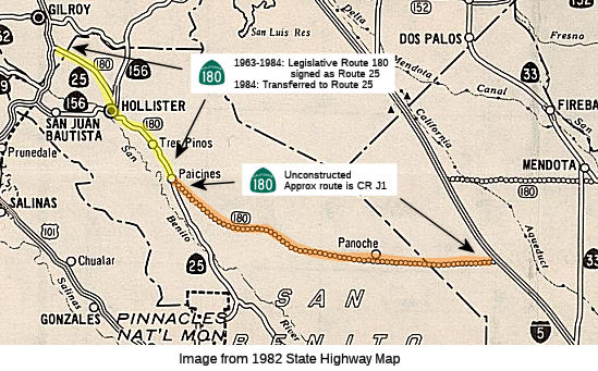 From Route 25 near Paicines to Route 5.
 Post 1964 Signage History
In 1963, the first two segments were defined as "(a) Route 101 near Gilroy to Route 156. (b) Route 156 to Route 99 near Fresno passing near Paicines and Mendota."
In 1965 Chapter 1371 split (b) into two segments: "(b) Route 156 to Route 5 passing near Paicines. (c) Route 5 to Route 99 passing near Mendota."
In 1984, Chapter 409 deleted (a), truncated (b), and clarified (d): "(b)
Route 156 Route 25 near Paicines to Route 5.
[...] (d) The General Grant Grove section of Kings Canyon National Park to
Kings Canyon River Kings Canyon National Park
boundary near Cedar Grove." The former (a) and the segment removed
from (b) were transferred to Route 25. This resulted in the current
definition of (a)
 Pre 1964 Signage History
In 1934, Route 180 was (to be) signed along the route from Jct Route 25 at Pacines to Jct. Route 7 (US 395) at Independence, via Fresno. Oddly, it was part of LRN 263, defined in 1959, and does not appear to have been part of the state highway system between 1933 and 1959. The routing was only "proposed" in 1963, and likely corresponds to a county route. "Tis a puzzlement"
 Status
 Unconstructed; the traversable local routing may be signed as County Route J1. The traversable route is Panoche Road and San Benito
County Road with no plans for improvement. The 32' San Benito County Road
has a structural section consisting of chip seal over Class 4 asphaltic
base. No state adoption is requested or recommended. Panoche Road between
San Benito County and I-5 is an unimproved dirt road. If a new state
highway is constructed in the area, a new alignment is recommended, and it
is unlikely any of the existing road would be incorporated. State adoption
of Panoche Road was not recommended.
Unconstructed; the traversable local routing may be signed as County Route J1. The traversable route is Panoche Road and San Benito
County Road with no plans for improvement. The 32' San Benito County Road
has a structural section consisting of chip seal over Class 4 asphaltic
base. No state adoption is requested or recommended. Panoche Road between
San Benito County and I-5 is an unimproved dirt road. If a new state
highway is constructed in the area, a new alignment is recommended, and it
is unlikely any of the existing road would be incorporated. State adoption
of Panoche Road was not recommended.
The 2013 Traversable Highways report notes that the closest routing is San Benito County Road, Panoche Road to the San Benito-Fresno County Line. No State adoption is requested or recommended (unsuitable). This 32' County Road of San Benito has a structural section consisting of a chip seal over Class 4 AB. In District 6, from the San Benito-Fresno County Line to I-5, the facility, Panoche Road, is an unimproved dirt road. If a new state highway is constructed in the area, it should be on new alignment. It is highly unlikely any of the existing road could be incorporated into a new highway. Any development of the road should be coordinated with District 5, since a large portion of the unimproved route is also in San Benito County. State adoption is not recommended.
Route 180 was projected as a "line on a map" west from its present
terminus at Route 33 to Route 25 in the vicinity of the Panoche Road
(County J1) intersection. No formal alignment has ever been adopted (the
first step to actually building a facility) between Route 33 and Route 25;
all iterations of "dotted line" over the years show it cutting off the
present northward arc on Panoche on a more direct trajectory. The last
iteration (from a Caltrans map circa 1994-95) showed the route extending
from the point where Route 180 turns NW to access Mendota due west to I-5,
jogging south on I-5 for several miles before continuing west to
approximately the Route 25/Panoche junction. Route 25 north from the
junction point through Hollister and on to the terminus at US 101 south of
Gilroy was, during the later '70's and early-to-mid '80's, legislatively
designated as Route 180 -- although Route 25 signage was retained. The
Caltrans white "paddle" markers along the roadside did read "180", with
mileage starting at the US 101 junction. Obviously, the Route 180
extension was intended to be a principal alternate route to the Valley --
one directly serving Fresno -- to augment Route 152 to the north. The
"180" portion of Route 25 was redesignated back to its original "25"
number sometime in the late '80's, and the cross-Coast Range section of
Route 180 hasn't been mentioned since. One would expect the usual
suspects: lack or lessening of political interest, lack of funding, etc.
But that area also poses some other issues: Route 25 essentially sits atop
the San Andreas Fault for its entire length, and the area is considered
"earthquake central" due to the small quakes occurring almost constantly
somewhere in the area. Also, Hollister is no longer the sleepy little San
Benito Valley town it once was; massive housing tracts are everywhere that
there is available land (except for some local vineyards whose owners have
refused to sell!), driven by the ongoing housing requirements of the Santa
Clara (Silicon) Valley to the north. Route 156 bypassed central Hollister
with an expressway in the early '90's, the Route 25 bypass (in arterial
form) was opened a few years ago. The chances for a high-capacity facility
connecting Route 25 SE of Hollister to Route 156 or US 101 are likely sunk
by the deployment of all that new housing. This situation likely puts a
substantial nail in the coffin of any Route 180 extension past I-5.
(Source: Scott Parker (Sparker) at AAroads, 7/5/2016)
 Freeway
[SHC 253.7] Entire portion. Added to the Freeway and Expressway system in 1959.
 From Route 5 to Route 99 passing near Mendota.
Post 1964 Signage HistoryIn 1963, the second segment of this route was defined as “(b) Route 156 to Route 99 near Fresno passing near Paicines and Mendota.”
In 1965 Chapter 1371 split (b) into two segments: “(b) Route 156 to Route 5 passing near Paicines. (c) Route 5 to Route 99 passing near Mendota.”
In 1984, Chapter 409 deleted (a), making this (b)
Pre 1964 Signage HistoryIn 1934, Route 180 was (to be) signed along the route from Jct Route 25 at Pacines to Jct. Route 7 (US 395) at Independence, via Fresno. Between I-5 and Route 33, it was part of LRN 263, defined in 1959, and does not appear to have been part of the state highway system between 1933 and 1959. The routing was only "proposed" in 1963, and likely corresponds to a county route. "Tis a puzzlement"
Between Route 33 and Route 99, this was part of LRN 41, defined in 1919.
A 1938 map shows it entering Fresno on Whites Bridge Avenue, then on B
Street to Fresno St, along Fresno St to Broadway, along Broadway to
Ventura Ave, and then continuing out of town to the national parks.
(Source: 1938 Map posted on FB by Joel Windmiller)
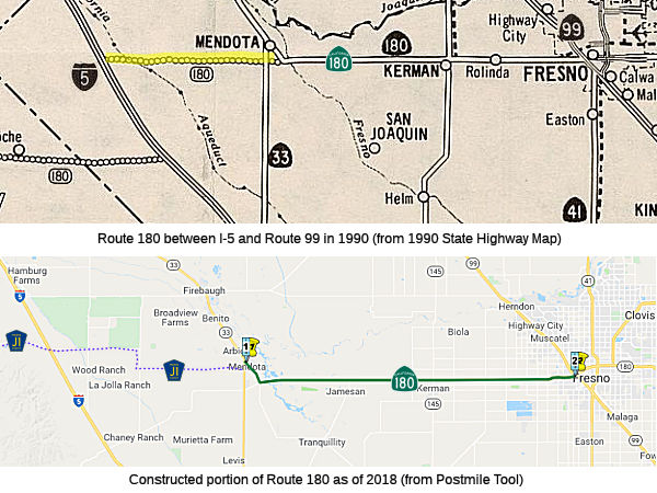
StatusI-5 Near Wood Ranch to Route 145 near Keeman via Mendota (~ FRE 23.585)
Unconstructed between Route 5 and Route 180 / Route 33 (~ FRE
23.585). The traversable local route is E on Shields between I-5 and
Fairfax, S on Fairfax Ave between Shields and Belmont, and E on Belmont
between Fairfax and Route 33 (this is all County Sign Route J1). This route was
recommended by a Fresno County report that concluded it was best for
regional traffic. Silver Creek, a natural drainage channel intersects
Belmont Ave about E mi. W of existing Route 180. This channel has caused
extensive flooding on Belmont Ave. Fresno County is prevented from raising
the grade of Belmont Avenue by a court order obtained by the surrounding
landowners. The district recommended that the state not adopt the road.
Route Adoption Study / Route Alignment Study - I-5 to Route 99
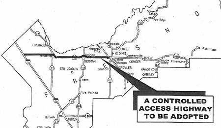
However, in the February 2001 CTC Agenda, there was a funding request to complete the environmental study for this segment. Additionally, there is a Caltrans information sheet stating that Caltrans proposes to conduct a Route Adoption Study on Route 180 for the unadopted segment from Mendota to I-5 (this is TCRP Project #93). The study could begin as soon as funding is available and would take approximately four years to complete, at an estimated cost of $7 million. The project would will add a needed east-west connection to I-5 with a new interchange that would enhance the farm to market shipping opportunities for the region, as well as closing a gap between Route 180, Route 33 and I-5.
According to the CTC in February 2006, work on Project #93 was initially to be limited to the environmental studies and preliminary engineering required for a Route Adoption Study for a segment of Route 180 between I-5 and Route 33, near Mendota. In February 2003, the Federal Highway Administration (FHWA) expressed their concern that Route 33 was not a logical terminus point for the project. Based on this concern, the Project Development Team stopped work on the Route Adoption Study and began work on the alternative of a “traversable highway”. However, in January 2004, the Council of Fresno Governments (Fresno COG) formed the Route 180 Steering Committee to consider a regional look at the entire Route 180 corridor and the concept of creating a four-lane expressway between Fresno and Interstate 5. The possibility of this new expressway required various alternatives to again be considered and, in July 2004, the Steering Committee re-initiated the Route Adoption Study extension from I-5 to Brawley Avenue, not to Route 33, as originally recommended by FHWA (which would be a new alignment for Route 180). In February 2006, the CTC reconsidered the allocation.
![[TCRP 93]](maps/180-tcrp-93.jpg) In April 2006, the CTC had a report on a study to evaluate a range of alternative route alignments for Route 180,
between I-5 and the vicinity of Valentine Avenue, west of Route 99 in
Fresno County. Upon completion of the Environmental Impact Report (EIR), a
route adoption will be requested from the California Transportation
Commission. The adopted route will eventually be developed into a
transportation facility as demand for improvements become known, and as
funding becomes available. The environmental document is anticipated to be
completed in Fiscal Year 2007-08. The alternatives being considered are:
(•) An existing alignment between Route 33 and the eastern project
limit, (•) A new northern alignments between Route 33 and the
eastern project limit, (•) Three new alignments between I-5 and
Route 33.
In April 2006, the CTC had a report on a study to evaluate a range of alternative route alignments for Route 180,
between I-5 and the vicinity of Valentine Avenue, west of Route 99 in
Fresno County. Upon completion of the Environmental Impact Report (EIR), a
route adoption will be requested from the California Transportation
Commission. The adopted route will eventually be developed into a
transportation facility as demand for improvements become known, and as
funding becomes available. The environmental document is anticipated to be
completed in Fiscal Year 2007-08. The alternatives being considered are:
(•) An existing alignment between Route 33 and the eastern project
limit, (•) A new northern alignments between Route 33 and the
eastern project limit, (•) Three new alignments between I-5 and
Route 33.
 In May 2013, the CTC approved funding a study to identify
the most appropriate location for a four-lane expressway for Route 180 to
connect the cities of Fresno, Kerman, Mendota, and Firebaugh, and the
unincorporated community of Rolinda. The project is programmed in the
Traffic Congestion Relief Program. The project will need an approval for a
route adoption from the Commission. The study requires environmental
funding only, and the total estimated cost is $7,000,000. The scope, as
described for the preferred alternative, is consistent with the project
scope programmed in the Traffic Congestion Relief Program. The current
traversable route for Route 180 is a two-lane conventional highway which
begins at Route 33 in the city of Mendota. It proceeds east along
Whitesbridge Avenue through the city of Kerman and the unincorporated
community of Rolinda to Brawley Avenue. At Brawley Avenue, Route 180
becomes a four-lane freeway through the city of Fresno. Currently, there
is no reliable and continuous regional east-west highway between the city
of Fresno and I-5. It is predicted that by year 2030, the section of SR
180 along West Whitesbridge Avenue between the cities of Kerman and Fresno
will have inadequate capacity to accommodate local and regional travel
demand. The “Route 180 Extension” project from I-5 to Route 33
was considered and recommended for approval on November 30, 1999. Governor
Gray Davis included $7 million in Transportation Congestion Relief Program
funds for environmental studies to extend Route 180 westward from Mendota
to I-5 in Fresno County. Research and development studies began in year
2000 to locate a workable alignment between I-5 and Route 33.
In May 2013, the CTC approved funding a study to identify
the most appropriate location for a four-lane expressway for Route 180 to
connect the cities of Fresno, Kerman, Mendota, and Firebaugh, and the
unincorporated community of Rolinda. The project is programmed in the
Traffic Congestion Relief Program. The project will need an approval for a
route adoption from the Commission. The study requires environmental
funding only, and the total estimated cost is $7,000,000. The scope, as
described for the preferred alternative, is consistent with the project
scope programmed in the Traffic Congestion Relief Program. The current
traversable route for Route 180 is a two-lane conventional highway which
begins at Route 33 in the city of Mendota. It proceeds east along
Whitesbridge Avenue through the city of Kerman and the unincorporated
community of Rolinda to Brawley Avenue. At Brawley Avenue, Route 180
becomes a four-lane freeway through the city of Fresno. Currently, there
is no reliable and continuous regional east-west highway between the city
of Fresno and I-5. It is predicted that by year 2030, the section of SR
180 along West Whitesbridge Avenue between the cities of Kerman and Fresno
will have inadequate capacity to accommodate local and regional travel
demand. The “Route 180 Extension” project from I-5 to Route 33
was considered and recommended for approval on November 30, 1999. Governor
Gray Davis included $7 million in Transportation Congestion Relief Program
funds for environmental studies to extend Route 180 westward from Mendota
to I-5 in Fresno County. Research and development studies began in year
2000 to locate a workable alignment between I-5 and Route 33.
In February 2019, it was reported that the Fresno
County Transportation Authority board agreed to team with Caltrans in
crafting a plan to extend Route 180 from Mendota to I-5. To be precise,
according to a report by FCTA Executive Director Mike Leonardo, the deal
calls for Caltrans to “initiate a Project Initiation Document to
determine the feasibility, cost, and schedule” of a two-lane highway
between the two points. According to Leonardo’s report, FCTA
officials and local transportation advocates in 2006 identified an
extension of Route 180 to the west as pivotal to improving east-west
circulation across the county. A Caltrans report in 2013 considered a
four-lane expressway. Alternatives were considered, as well. According to
the report, Caltrans decided the best route would be the current Route 180
alignment from Fresno to Kerman “with some minor realignments near
Kerman to bypass the urbanizing area of that community, and a bypass of
Mendota.” From Mendota to I-5, the (Caltrans) Study Report selected
a preferred alternative that followed the Shields Avenue alignment. This
alignment was selected after considerable outreach to the westside
communities. The California Transportation Commission has given its
blessing to this vision. It turns out that the Route 180 extension to I-5
is, according to Leonardo’s report, “the last remaining Rural
Tier 1 project that has not yet received Measure C funding. The other
Rural Tier 1 projects are either complete, or are in the environmental,
design, right of way or construction phases.” Leonardo’s
report goes on to say, “It appears that there may be sufficient
Measure C funds to build a 40’ wide two-lane conventional highway
along the Shields Avenue alignment that could be dedicated to Caltrans as
Route 180. This two-lane conventional highway would be compatible with any
future widening or upgrading as contemplated in the Route Adoption
Report.” Leonardo’s report says there are advantages and
disadvantages to the Shields Avenue alignment: “Shields is an
existing 32’ paved county road between Fairfax Avenue and I-5
(approximately 9 miles). There is an existing interchange on I-5 at
Shields. At Fairfax and Route 33 north of Mendota (approximately 9 miles),
Shields is only a line on a map. Fresno County has dedicated road
easements for part of the distance, but the remainder is private farm
property.” The San Joaquin Valley Railroad operates a nearby line,
Leonardo’s report says, which could complicate matters. Getting a
handle on this and a multitude of other issues is the goal of
Caltrans’ Project Initiation Document. This document is expected to
cost $300,000 and take nine months to complete. If Caltrans comes back
with a favorable prognosis from a feasibility and funding angle,
Leonardo’s report says, “the next step would be to authorize
Caltrans to begin environmental studies and preliminary engineering for a
build project.”
(Source: CV Observer, 2/20/2019)
In June 2016, the CTC approved for future consideration of funding a project in Fresno County that will stabilize the bridge approaches at the Fresno Slough Bridge (180 FRE 26.95) on Route 180 near the city of Mendota. The project is programmed in the 2016 State Highway Operation and Protection Program. The total programmed amount is $4,062,000 for capital and support. Construction is estimated to begin in Fiscal Year 2016- 17. The scope, as described for the preferred alternative, is consistent with the project scope programmed by the Commission in the 2016 State Highway Operation and Protection Program. A copy of the MND has been provided to Commission staff. The project will result in less than significant impacts to the environment after mitigation. The following resource areas may be impacted by the project: biological resources. Avoidance and minimization measures will reduce any potential effects on the environment. These measures include, but are not limited to, pre-construction surveys will be conducted for all species of concern in the project area, ESA fencing will be installed around sensitive areas, and monitoring of sensitive areas will be done by a qualified biologist.
Route 145 near Keeman (~ FRE 42.658) to Route 99 W of Fresno
Dickenson Ave. Roundabout (06-Fre-180 PM 47.3/48.0)
In January 2020, the CTC amended the following into the
2018 SHOPP: Item 25: 06-Fre-180 PM 47.3/48.0. PPNO 7009 ProjID 0619000172
EA 0Y410. On Route 180 Near Rolinda, from 0.3 mile west to 0.3 mile east
of Dickenson Avenue. Construct roundabout at Dickenson Ave.. (Concurrent
COS allocation under Resolution FP-19-50, January 2020.) Funding:
PA&ED: $1,600K, PS&E $1,700K, R/W Supp $800K, Con Sup $1,550K, R/W
Cap $830K, Const Cap $5,600. Total $12,080K. Begin Const: 7/2/2024. The
CTC also approved the following financial allocation: 06-Fre-180
47.3/48.0. PPNO 7009. ProjID 0619000172. EA 0Y410. Route 180 near Rolinda,
from 0.3 mile west to 0.3 mile east of Dickenson Avenue. Construct
roundabout. (Concurrent Amendment under SHOPP Amendment 18H-014, January
2020.) PA&ED $1,600,000. Unsurprisingly, the project was included in
the 2020 SHOPP.
(Source: January 2020 CTC Agenda, Agenda Item
2.1a.(1a) Item 25, 2.5b.(2a) #17; 2020 Approved SHOPP a/o May 2020)
In May 2022, the CTC approved for future consideration
of funding the following project for which a Negative Declaration (ND) has
been completed: 06-Fre-180, PM 47.4/47.8. Dickenson Avenue Roundabout.
Construct a single-lane roundabout at the intersection of Route 180 and
Dickenson Avenue in Fresno County. (PPNO 7009). The project is located on
Route 180 between PM 47.4 and 47.8 in Fresno County. The
proposes project includes constructing a single lane roundabout at the
intersection of Route 180 and Dickenson Avenue. The roundabout elements
include traveled lanes, a truck apron, landscape buffer, curb ramps,
splitter islands and a shared-use path. This project is currently
programmed in the 2022 SHOPP for a total of $12,080,000, which includes
Right of Way (capital), and Construction (capital and support).
Construction is estimated to begin in 2024-25. The scope, as described for
the preferred alternative, is consistent with the project scope as
programmed by the Commission in the 2022 SHOPP. A copy of the ND has been
provided to Commission staff.
(Source: May 2022 CTC Agenda, Agenda Item 2.2c.(1))
In May 2022, the CTC approved the following
pre-construction phase SHOPP allocation: $2,500,000. 06-Fre-180 47.3/48.0.
PPNO 06-7009; ProjID 0619000172; EA 0Y410. Route 180 Near Rolinda, from
0.3 mile west to 0.3 mile east of Dickenson Avenue. Construct roundabout.
(Concurrent consideration of funding under Resolution E-22-28; May 2022.)
Allocation FY 23-24: PS&E $1,700,000; R/W Sup $800,000.
(Source: May 2022 CTC Agenda, Agenda Item 2.5b.(2a) #17)
In June 2023, the CTC amended the following project in
the 2022 SHOPP: 06-Fre-180 47.3/48.0. PPNO 06-7009; ProjID 0619000172; EA
0Y410. Route 180 Near Rolinda, from 0.3 mile west to 0.3 mile east of
Dickenson Avenue. Construct roundabout. Note: Decrease R/W capital
because a lesser than originally anticipated number of parcels has been
realized for environmental clearance. Increase construction capital to
expand the roundabout to accommodate future traffic volumes. Allocation
Changes ($ × 1,000): R/W Cap $830 $441; Const
Cap $5,600 $7,504; TOTAL $12,080 $13,595.
(Source: June 2023 CTC Agenda, Agenda Item 2.1a.(1d) #47)
Western Extension: Brawley Avenue (apx 180 FRE R53.614) to the Route 99/Route 180 Interchange (~FRE R56.161)
![[Map]](maps/180-93-seg2.jpg) By March 2007, construction was to begin on
Segment 2 of the western extension, which includes construction of 2.5
miles of a four-lane freeway from Brawley Avenue (apx 180 FRE R53.614) to
Marks Avenue (apx. 180 FRE R54.668), thena six- lane freeway to the Route 99/Route 180 Interchange (~FRE R56.161). There will be a full interchange
at Marks Avenue. There will be a signalized intersection at Brawley Avenue
and cul-de-sacs at Whitesbridge Road, Valentine and Hughes Avenues.
Construction should be completed by late March 2008.
By March 2007, construction was to begin on
Segment 2 of the western extension, which includes construction of 2.5
miles of a four-lane freeway from Brawley Avenue (apx 180 FRE R53.614) to
Marks Avenue (apx. 180 FRE R54.668), thena six- lane freeway to the Route 99/Route 180 Interchange (~FRE R56.161). There will be a full interchange
at Marks Avenue. There will be a signalized intersection at Brawley Avenue
and cul-de-sacs at Whitesbridge Road, Valentine and Hughes Avenues.
Construction should be completed by late March 2008.
In May 2009, the CTC relinquished right of way in the county of Fresno along Route 180 from South Brawley Avenue to South Marks Avenue, consisting of superseded highway right of way and collateral facilities. (Apx 180 FRE R53.614 to 180 FRE R54.668)
In September 2009, the CTC approved relinquishment of right of way in the city of Fresno along Route 180 from the west city limits, near South Valentine Avenue, to Hughes West Diagonal, consisting of superseded highway right of way and collateral facilities. (Nr. 180 FRE R54.108 to 180 FRE R55.447)
As of 2004, the Route 180/Route 99 interchange (180 FRE R56.252) is now complete, although the Route 180 freeway only extends as far west as Hughes Avenue. However, because of this finished constrution, Route 180 no longer follows Route 99 south and Stanislaus Street to reach Whitesbridge Avenue, instead using Hughes Avenue to connect to Whitesbridge Avenue westbound.
The 2018 STIP, approved at the CTC March 2018 meeting, appears to include and adjust funding for PPNO 6489, 06-Fre-180 R53.4/R55.8, In and near the city of Fresno from 0.2 miles west of Brawley Avenue to Teilman Avenue. Highway planting.
The SAFETEA-LU act, enacted in August 2005 as the reauthorization of TEA-21, provided the following expenditures on or near this route:
 Naming
The segment from Route 33 to Route 99 (~ FRE 23.606 to FRE R56.252), and upon completion, from I-5 to Route 33, is officially named the "Deran Koligian Memorial Highway". Deran Koligian, the son of Armenian immigrants, was born in Fresno County and raised on his family farm in the Kearney Park community. He served in the South Pacific in World War II, and after the war, returned home to attend Fresno State College and to manage his family's farm. He began his public service in 1957, spending 24 years on school boards in western Fresno County, including the Madison Elementary School Board and the Central High School Board. He was elected to the Fresno County Board of Supervisors in 1982. Deran Koligian was a strong supporter of agriculture and a protector of agricultural lands from urban encroachment; and also was a vocal supporter of Measure C, which provided local augmentation for the construction and maintenance of state highways and local roads. As a member of the Fresno Transportation Authority, he was instrumental in securing funds for numerous road and highway transportation projects, including the extension and widening of Route 180 in western Fresno County. He was an active member of St. Paul's Armenian Church and was the first Armenian-American to be elected to office in Fresno County. He served with distinction until he death on December 11, 2001. Named by Senate Concurrent Resolution 94, Chapter 158, September 11, 2002.
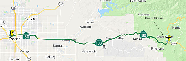
The segment of Route 180 from the intersection with Brawley Avenue to the Intersection with Highland Avenue (~ FRE 53.587 to FRE 67.59) is named the Sequoia-Kings Canyon Freeway. It was named for its terminus in the Sequoia National Park and the Kings Canyon National Park. This park is the home to immense mountains, deep canyons, and huge sequoia trees. Thanks to their huge elevational range, 1,500' to 14,491', these parks protect stunningly diverse habitats. The Generals Highway climbs over 5000 feet from chaparral and oak-studded foothills to the awe-inspiring sequoia groves. From there, trails lead to the high-alpine wilderness which makes up most of these parks. Beneath the surface lie over 200 fascinating caverns. The park was named after the Giant Sequoia tree, the Sequoia gigantia. The name is traced to Indian Chief Sequoya, creator of the Cherokee alphabet, whose name means "opossum." In volume of total wood, the giant sequoia stands alone as the largest living thing on Earth. Its nearly conical trunk, like a club, not a walking stick, shows why. At least one tree species lives longer, one has a greater diameter, three grow tall, but none is larger. In all the world, sequoias grow naturally only on the west slope of the Sierra Nevada, most often between 5,000 and 7,000 feet. There are some 75 groves in all. The General Sherman tree is between 2,300 and 2,700 years old. Its largest branch is almost seven feet in diameter. Each year the General Sherman adds enough wood growth to make a 60-foot-tall tree of usual proportions. Named by Senate Concurrent Resolution 25, Chapter 85, in 1997.
Freeway[SHC 253.7] Entire portion. Added to the Freeway and Expressway system in 1959.
 From Route 99 near Fresno to the General Grant Grove section of the Kings
Canyon National Park.
From Route 99 near Fresno to the General Grant Grove section of the Kings
Canyon National Park.
Post 1964 Signage HistoryThis segment remains as defined in 1963. In 1963, the segment from Brawley Avenue (west of Route 99) to 0.1 mile west of Highland Avenue (east of Route 99 and of City of Fresno) was adopted as a freeway and as a part of the California Freeway and Expressway System by the California Highway Commission. In 1995, the Commission adopted 12.3 miles of Route 180 as controlled access highway from 0.1 mile west of Temperance Avenue to Frankwood Avenue in the county of Fresno. A portion of the controlled access highway alignment from 0.1 mile west of Temperance Avenue to 0.1 mile west of Highland Avenue runs parallel to the adopted freeway but did not connect to the freeway alignment on the western end. In 1996, the Commission adopted as a freeway a segment of the 1995 controlled access highway corridor, from N. Fowler Avenue to 0.2 mile west of DeWolf Avenue and rescinded a portion of the 1963 adopted freeway from N. Fowler Avenue to 0.1 mile west of Highland Avenue, thus modifying the controlled access highway corridor to begin at 0.2 miles west of DeWolf Avenue.
Pre 1964 Signage HistoryIn 1934, Route 180 was (to be) signed along the route from Jct Route 25 at Pacines to Jct. Route 7 (US 395) at Independence, via Fresno. It was LRN 41, defined in 1919. Before its present routing was established, Route 180 entered Fresno via Whitesbridge and B, then after US 99, it ran continued south on US 99/Broadway to Ventura Street, and then continued east on Ventura. It was formerly a county road.
Tom Fearer did some detailed investigations on the history of Route 180, and posted the following on a blog on Gribblenation with loads of detailed maps:
Tom Fearer notes in the Gribblenation Blog that the original Sign State
Route definition of Route 180 announced in the August 1934 California
Highways & Public Works, was intended to cross the Sierra Nevada
Mountains to an eastern terminus at Independence via Kings Canyon and
Kearsarge Pass. In 1931, CHPW discussed a cooperative survey between the
Division of Highways and Forest Service to survey a route for a new
highway through Sequoia National Forest and Inyo National Forest. LRN 41
was not extended E of Kings Canyon, implying that any road from the Kings
Canyon east over Kearsarge Pass to Independence would have been maintained
by the Forest Service and Inyo County (or was not going to be adopted into
the state system until someone else built it). Several early Sign State
Route era maps show Route 180 existing from near Kearsarge Pass east via
Onion Valley Road to Independence (early Sign State Routes were signed by
the Auto Clubs and not restricted to State Maintained Highways). Route 180
can be clearly seen on Onion Valley Road along with the planned connecting
route over the Sierra Nevada Mountains to the Kings River Canyon on the
1935 Goshua Highway Map of California. On March 4th 1940 General Grant
National Park was expanded into what is now Kings Canyon National Park.
The new boundary of Kings Canyon National Park annexed a great deal of
Sequoia National Forest north from the boundary of Sequoia National Park
towards the planned route of the Piute Pass Highway (planned Route 168).
It seems that the National Park Service didn't have an interest in
buildings a Trans-Sierra Highway via the Kings River Watershed or allowing
the Piute Pass Highway as both routes more or less faded into obscurity.
The John Muir Wilderness was established in 1964 which enhanced
protections over existing National Forest Lands. The John Muir Wilderness
was enabled by the Wilderness Act of 1964 which largely sought to stop
highway development in the Sierra Nevada Mountains. The John Muir
Wilderness largely seems to have been an attempt to stop numerous planned
Trans-Sierra Highways.
(Source: Gribblenation Blog, "Onion Valley Road; former California State Route 180 to Kearsarge Pass", August 2020)
StatusRoute 99 (~FRE R56.252) to the Vicinity of Sanger (~ FRE 71.632)
2007 CMIA. Three projects on Route 180 in Fresno County were submitted to the Corridor Mobility Improvement Account for funding. These projects were braided ramps between Route 41 (180 FRE R58.758) & Route 168 (180 FRE R60.144) ($30M requested); construction of an expressway from Academy (180 FRE 71.605) to Trimmer Springs (180 FRE 74.947) ($45.2M), and construction of an expressway from Trimmer Springs (180 FRE 74.947) to Frankwood (180 FRE 77.959) ($46.5M). None of these projects were recommended for funding.
In September 2005, the CTC considered relinquishement of former Route 180 right of way in the City of Fresno, at G Street and Divisadero Street, consisting of reconstructed and relocated city streets. (apx 180 FRE R56.686, 180 FRE R56.85)
Part (3) is constructed to freeway standards from Fresno to Chestnut Avenue (~ FRE R60.912), past Route 41. It looks like the planned freeway routing will go east as far Leonard Avenue (~ FRE 67.088). This freeway bypasses the original routing along Ventura Avenue (in fact, the signs have been removed from Ventura between Route 99 to Chestnut Avenue. Some of the original routing has been relinquished. For example, the California Transportation Commission, at its June 2000 meeting, discussed relinquishing the old routing of Route 180 from PM 58.0-61.4 in the City of Fresno (Agenda Item 2.3c). Curb ramps had to be constructed before this was done (at at cost of $317K).
According to Joe Rouse, in May 2001:
It is fully signed as Route 180. On Route 99, the exit to Route 180 used to be signed as "To Route 41 North", but it is now signed as Route 180 East, Kings Canyon. They used greenout on those signs, and the letters on the greenout are not button copy and although it is not reflective greenout, it has the state shield shape found on the new reflective signs. On Route 41, the exit used to be signed as "To Route 99 North", but now it is signed as "Route 180, Kings Canyon, Mendota". These are new button copy sign panels, not greenout. The Route 180 freeway mainline ends at Cedar Ave. You can see where the future mainline lanes will be. Traffic is forced onto ramps that end at Chestnut Ave. and traffic continuing east on Route 180 is directed south onto Chestnut to Kings Canyon Rd. This routing is well signed for both east and westbound traffic. No "TEMPORARY" plates are used over the Route 180 shields on Chestnut.There are no Route 180 shields on the Route 99/Route 180 multiplex between the Route 180 freeway and Stanislaus St. The Route 180 shields at the exit to Ventura St. on Route 99 in downtown Fresno have been removed (not greened out). Interestingly, the connector from the new Route 41 to NB Route 99 has a sign for Ventura St. with a large green space on it for a Route 180 shield. However, I didn't see any residue or greenout that indicated that a shield had been on there.
In June 2012, the Fresno Bee reported on an upcoming project that will improve the merges on Route 180 between Route 41 and Route 168. The goal of the $49 million project is to build "braided" ramps intended to reduce the weaving and ease congestion for drivers. Specifically, a pair of bridges -- one on each side of the freeway -- will eliminate the need for merging drivers to swerve across each other's paths to get where they want to go. The major features of the work are the two bridges. On the north side of the highway, one bridge will carry cars coming from southbound Route 168 onto westbound Route 180 over the motorists that want to get off Route 180 onto Route 41. The other bridge will be for drivers on eastbound Route 180 who want to get onto northbound Route 168. That traffic will be carried over the drivers coming off Route 41 trying to get onto eastbound Route 180. Another feature of the work will include bypass lanes so that drivers going from Route 41 to Route 168, or from Route 168 to Route 41, can do so without merging onto the main lanes of Route 180, further reducing traffic congestion. Metering lights to control the flow of traffic merging onto the freeways are a third part of the plan. The Cedar Avenue on-ramp to westbound Route 180 is being widened to two lanes to allow metering lights, and metering also is planned on the ramp from westbound Route 180 to southbound Route 41.
(Source: Fresno Bee, 6/19/2012)
Route 168 (FRE R60.146) to Clovis Avenue (FRE R62.893)
In April 2002, the CTC considered (Agenda Item 2.5b.(1)) STIP Project #4, which would construct new six lane freeway on eight lane freeway alignment from Route 168 to Fowler Avenue (FRE R63.934).
Construction began in Summer 2002 on Route 180 through Southeast Fresno, going as far as Clovis Ave, according to a June 25, 2002 report in the Fresno Bee. This involved four miles of new road, six lanes, and 65 tons of asphalt. According to a map in the article, the segment from Chestnut Ave to Clovis Ave cost $80 million, and construction started in August 2002, with completion expected in 2½ years. The segment from Clovis Ave to Locan Ave cost $48 million, with construction beginning in August 2004. The expressway from Locan Ave to Academy Ave will cost $47 million, and construction begins in 2005. The expressway from Academy Ave to Trimmer Springs Rd in Centerville will cost $29 million, and construction starts in 2006. Lastly, the segment from Trimmer Springs Road to Frankwood Ave will cost $23 milllion, with construction also beginning in 2006. This extension will be called the Sequoia Freeway.
According to the Fresno Bee, in late September 2005, the Sequoia Freeway from the Route 168 junction east to Clovis Avenue opened. The new road has already set off a frenzy of new home development in southeast Fresno, where about 5,000 houses are under construction, approved or awaiting review east of Clovis Avenue. The project also includes a final pair of ramps connecting Freeway 168 and Freeway 180 at their interchange east of downtown Fresno. Work is scheduled to in 2006 on the $47 million western segment from the Hughes-West Diagonal to Brawley Avenue, where the new freeway will rejoin the existing rural Route 180. The project will include an overpass at Hughes/West and is scheduled to be finished in 2008. The final freeway segment east of the new section, from Clovis Avenue to a junction with the existing highway at Temperance Avenue, is further out, as funding for that segment has been delayed by the state's budget crisis, and work is scheduled to begin in 2008-09.
In December 2005, the CTC considered relinquishment of rights of way (1) in the County of Fresno, from North Winery Avenue to Sunnyside Avenue, consisting of reconstructed and relocated county roads, frontage roads, and cul-de-sacs (06-Fre-180-PM R61.2/R63.2), and (2) in the City of Fresno, between Chestnut Avenue and Clovis Avenue, consisting of reconstructed and relocated city streets, frontage roads, and cul-de-sacs (06-Fre-180-PM R61.1/R62.9).
In July 2007, the CTC relinquished right of way in the city of Fresno, between Chestnut Avenue and Clovis Avenue, consisting of superseded highway right of way (6-Fre-180-PM 61.43/63.04), and right of way in the county of Fresno, between Peach Avenue and Clovis Avenue, consisting of superseded highway right of way (6-Fre-180-PM 62.68/63.45). In Feburary 2008, there was a similar relinquishment, between Peach Avenue and Minnewawa Avenue, consisting of superseded highway right of way that is appurtenant to a previously relinquished superseded highway and inadvertently omitted from said relinquishment (6-Fre-180-PM 62.70).
Clovis Avenue to Temperance Avenue (~ FRE R62.898 to FRE R65.3)
In May 2001, the CTC considered TCRP Project #91 to build a new expressway E of Clovis, Clovis Avenue to Temperance Avenue in Fresno County. In August 2004, the CTC has a request to amend the proposal to update project schedule and funding plan previously approved.
In December 2009, the segment between Clovis and Temperance avenues opened. This completion also marked the start of construction for the next project on Route 180: widening it from two to four lanes between Temperance and Academy avenues, a more than six-mile stretch. Federal stimulus funds approved by Congress in February are covering $18.3 million of the $29.6 million construction cost for the Temperance-Academy segment. The rest is mainly from Measure C, Fresno County's half-cent transportation sales tax. The stimulus money allowed Caltrans to move up construction from 2012 to 2009.
In May 2011, the CTC approved relinquishment of right of way in the city of Fresno along Route 180 between South Clovis Avenue and Temperance Avenue, consisting of superseded highway right of way and collateral facilities
In April 2012, the CTC authorized relinquishment of right of way in the county of Fresno on Kings Canyon Avenue (Route 180) and along realigned Route 180 between Clovis Avenue and Locan Avenue, consisting of superseded highway right of way and collateral facilities (06-Fre-180-PM 63.90/66.06).
In March 2022, the CTC authorized relinquishment of right of way,
consisting of collateral facilities, in the city of Fresno along Route 180
on Armstrong Avenue (06-Fre-180-PM R64.44, 1 segment). The City, by letter
dated February 11, 2022, agreed to waive the 90-day notice requirement and
accept title upon relinquishment by the State.
(Source: March 2022 CTC Agenda, Agenda Item 2.3c)
In August 2012, the CTC approved relinquishment of right of way in the county of Fresno along Route 180 at Locan Avenue, consisting of collateral facilities (06-Fre-180-PM 66.05).
Temperance to DeWolf (~ FRE R65.3 to FRE 66.6)
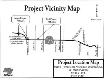 In October 2008, the CTC considered a route adoption for a future freeway from Temperance to DeWolf
Avenue near Fresno. This mitigated negative declaration in Fresno County
will update the Department’s freeway agreement and identify an
interchange for future construction. This project for the freeway
agreement and subsequent route adoption only is fully funded. Funding for
the interchange has yet to be identified. A separate project and
environmental evaluation will be conducted once a future build project is
proposed. Segment 1 of the Kings Canyon Expressway project, in eastern
Fresno County, from Locan Avenue to Quality Avenue, is expected to start
construction in August 2009. Traffic studies for the Kings Canyon
Expressway project projected that the Level of Service (LOS) at DeWolf
Avenue intersection will become level F (breakdowns of traffic flow,
recurring points of congestion, peak hour flow rates are at highway
capacity) in 2019, less than 10 years after completion of the proposed
expressway project. The Supplemental Project Report for the expressway
project, approved on December 20, 2007, recognized the need for an
interchange at DeWolf Avenue. However, due to funding constraints,
construction of a new interchange at DeWolf Avenue is not feasible at this
time. In the meantime, the Kings Canyon Expressway Project will improve
and signalize this intersection and will include two through lanes in each
direction on Route 180, right-turn lanes, a westbound left-turn lane and
dual eastbound left-turn lanes at DeWolf Avenue. A subsequent project will
construct an interchange to provide adequate capacity for a 20-year design
period.
In October 2008, the CTC considered a route adoption for a future freeway from Temperance to DeWolf
Avenue near Fresno. This mitigated negative declaration in Fresno County
will update the Department’s freeway agreement and identify an
interchange for future construction. This project for the freeway
agreement and subsequent route adoption only is fully funded. Funding for
the interchange has yet to be identified. A separate project and
environmental evaluation will be conducted once a future build project is
proposed. Segment 1 of the Kings Canyon Expressway project, in eastern
Fresno County, from Locan Avenue to Quality Avenue, is expected to start
construction in August 2009. Traffic studies for the Kings Canyon
Expressway project projected that the Level of Service (LOS) at DeWolf
Avenue intersection will become level F (breakdowns of traffic flow,
recurring points of congestion, peak hour flow rates are at highway
capacity) in 2019, less than 10 years after completion of the proposed
expressway project. The Supplemental Project Report for the expressway
project, approved on December 20, 2007, recognized the need for an
interchange at DeWolf Avenue. However, due to funding constraints,
construction of a new interchange at DeWolf Avenue is not feasible at this
time. In the meantime, the Kings Canyon Expressway Project will improve
and signalize this intersection and will include two through lanes in each
direction on Route 180, right-turn lanes, a westbound left-turn lane and
dual eastbound left-turn lanes at DeWolf Avenue. A subsequent project will
construct an interchange to provide adequate capacity for a 20-year design
period.
In October 2012, the CTC authorized relinquishment of right of way in the county of Fresno along Route 180 between De Wolf Avenue and Quality Avenue, consisting of collateral facilities (06-Fre-180-PM 66.57/72.34).
In December 2014, the CTC authorized relinquishment of right of way in the county of Fresno along Route 180 at Thompson Avenue (~ FRE 68.096), consisting of a collateral facility inadvertently omitted from a previous relinquishment. The County, by controlled access highway agreement dated April 28, 2009, agreed to accept title upon relinquishment by the State. The 90-day notice period expired October 10, 2014.
In December 2014, the CTC vacated right of way in the county of Fresno along Route 180 (East Kings Canyon Road) between South Bethel Avenue and South Academy Avenue, consisting of superseded highway right of way no longer needed for State highway purposes (~ FRE 70.621 to FRE 71.624). The County was given a 90-day notice of intent to vacate and did not protest such action.
Vicinity of Sanger (~ FRE 71.632) to Route 63 (~ FRE 87.678)
Quality Avenue to Smith Avenue near Sanger (FRE 65.6 to FRE 84.0)
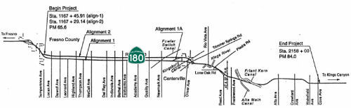 In January 2013, the CTC approved for future consideration of funding a project that will construct
a four lane expressway on the existing alignment on Route 180 from Quality
Avenue to Smith Avenue. The project is programmed in the 2012 State
Transportation Improvement Program for right of way. At the January 2013
CTC meeting, the project will be programmed in the Proposition 1B State
and Local Partnership Program. The total estimated cost for capital and
support is $23,000,000. Construction is estimated to begin in FY 2012-13.
The scope, as described for the preferred alternative, is consistent with
the project scope programmed in the 2012 State Transportation Improvement
Program and the State and Local Partnership Program.
In January 2013, the CTC approved for future consideration of funding a project that will construct
a four lane expressway on the existing alignment on Route 180 from Quality
Avenue to Smith Avenue. The project is programmed in the 2012 State
Transportation Improvement Program for right of way. At the January 2013
CTC meeting, the project will be programmed in the Proposition 1B State
and Local Partnership Program. The total estimated cost for capital and
support is $23,000,000. Construction is estimated to begin in FY 2012-13.
The scope, as described for the preferred alternative, is consistent with
the project scope programmed in the 2012 State Transportation Improvement
Program and the State and Local Partnership Program.
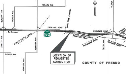 In conjunction with the above project, in January 2013 the CTC authorized of a new public
road connection as a temporary connection to Route 180 from Kings Canyon
South Frontage Road at Post Mile (PM) 73.8, in the county of Fresno. The
proposed temporary new public road connection is necessary to provide
access to Route 180 from properties adjoining the Kings Canyon South
Frontage Road during the construction of segment 2. The Kings Canyon
Expressway project, Segment 2, proposes to improve safety and increase
highway capacity by converting Route 180 from a two-lane conventional
highway to a four-lane expressway starting at 0.2 mile west of Quality
Avenue to just east of Trimmer Springs Road. This segment will connect
with the previously constructed Segment 1, west of Quality Avenue. In
mid-2012, it was determined that environmental permits necessary for
project delivery could not be obtained for the Centerville Kingsburg
Canal, also known as Kingsberg Canal, and China Slough locations to meet
the accelerated project schedule needed for Corridor Mobility Improvement
Account (CMIA) funding. Therefore, the Segment 2 project scope was revised
to meet the CMIA funding deadline. The eastern project limit was moved
from east of Trimmer Springs Road to a location west of the Centerville
Kingsburg Canal. Unfortunately, the project did not receive the CMIA
funding requested but it was decided to move forward with the revised
project scope. Local Measure funding and State and Local Partnership
Program funding (Proposition 1B) will be used to fully fund this project.
Construction of Segment 2 is expected to start August, 2013. Project scope
for Segment 3 will be revised to include the area from the revised Segment
2 project limit to the China Slough location east of Trimmer Springs Road.
Due to the Segment 2 project limit change, a temporary new public road
connection is proposed to Route 180 from Kings Canyon South Frontage Road
on the south side of Route 180. The connection is necessary to provide
access to properties adjoining the frontage road to Route 180 during the
Segment 2 construction period. The temporary connection will be in service
starting July 2013 until the transition to Segment 3 is constructed
(approximately July 2016). The frontage road associated with the new
public connection will be relinquished to Fresno County upon completion of
Segment 2.
In conjunction with the above project, in January 2013 the CTC authorized of a new public
road connection as a temporary connection to Route 180 from Kings Canyon
South Frontage Road at Post Mile (PM) 73.8, in the county of Fresno. The
proposed temporary new public road connection is necessary to provide
access to Route 180 from properties adjoining the Kings Canyon South
Frontage Road during the construction of segment 2. The Kings Canyon
Expressway project, Segment 2, proposes to improve safety and increase
highway capacity by converting Route 180 from a two-lane conventional
highway to a four-lane expressway starting at 0.2 mile west of Quality
Avenue to just east of Trimmer Springs Road. This segment will connect
with the previously constructed Segment 1, west of Quality Avenue. In
mid-2012, it was determined that environmental permits necessary for
project delivery could not be obtained for the Centerville Kingsburg
Canal, also known as Kingsberg Canal, and China Slough locations to meet
the accelerated project schedule needed for Corridor Mobility Improvement
Account (CMIA) funding. Therefore, the Segment 2 project scope was revised
to meet the CMIA funding deadline. The eastern project limit was moved
from east of Trimmer Springs Road to a location west of the Centerville
Kingsburg Canal. Unfortunately, the project did not receive the CMIA
funding requested but it was decided to move forward with the revised
project scope. Local Measure funding and State and Local Partnership
Program funding (Proposition 1B) will be used to fully fund this project.
Construction of Segment 2 is expected to start August, 2013. Project scope
for Segment 3 will be revised to include the area from the revised Segment
2 project limit to the China Slough location east of Trimmer Springs Road.
Due to the Segment 2 project limit change, a temporary new public road
connection is proposed to Route 180 from Kings Canyon South Frontage Road
on the south side of Route 180. The connection is necessary to provide
access to properties adjoining the frontage road to Route 180 during the
Segment 2 construction period. The temporary connection will be in service
starting July 2013 until the transition to Segment 3 is constructed
(approximately July 2016). The frontage road associated with the new
public connection will be relinquished to Fresno County upon completion of
Segment 2.
In January 2016, the CTC authorized relinquishment of right of way in the county of Fresno along Route 180 between Quality Avenue and Smith Avenue, consisting of relocated or reconstructed county roads. The County, by controlled access agreement dated April 28, 2009, agreed to accept title upon relinquishment by the State. The 90-day notice period expires December 27, 2015.
In August 2022, the CTC authorized relinquishment of
right of way in the county of Fresno along State Route 180 (East Kings
Canyon Road) from approximately 1 mile west of Oliver Avenue, easterly, to
approximately 0.5 miles east of South Frankwood Avenue, under terms and
conditions as stated in the Controlled Access Agreement dated April 28,
2009. The 90-day notice was acknowledged on March 28, 2022, and the 90-day
notice period expired on June 26, 2022.
(Source: August 2022 CTC Agenda, Agenda Item 2.3c)
Centerville to Minkler (~ FRE 74.612 to FRE 77.975)
 In December 2014, the CTC approved for future consideration of funding a project that will
realign and widen a segment of Route 180 from two lanes to four lanes near
the city of Fresno (roughly Smith Ave to Frankwood) and connect this
segment with the previously constructed Kings Canyon Expressway Segment 2.
The project is programmed in the 2014 State Transportation Improvement
Program. The total estimated cost is $90,948,000 for capital and support.
Construction is estimated to begin in Fiscal Year 2015-16. The scope, as
described for the preferred alternative, is consistent with the project
scope programmed by the Commission in the 2014 State Transportation
Improvement Program.
In December 2014, the CTC approved for future consideration of funding a project that will
realign and widen a segment of Route 180 from two lanes to four lanes near
the city of Fresno (roughly Smith Ave to Frankwood) and connect this
segment with the previously constructed Kings Canyon Expressway Segment 2.
The project is programmed in the 2014 State Transportation Improvement
Program. The total estimated cost is $90,948,000 for capital and support.
Construction is estimated to begin in Fiscal Year 2015-16. The scope, as
described for the preferred alternative, is consistent with the project
scope programmed by the Commission in the 2014 State Transportation
Improvement Program.
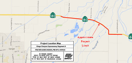
In March 2016, it was reported that a recently
announced $754 million cut to the state transportation budget over the
next five years has put in jeopardy the widening of Route 180 between
Centerville and Minkler on the way to Kings Canyon and Sequoia National
Parks, as well as the continued widening of Route 99 in Tulare County.
(Source: Fresno Bee, 3/23/2016)
In October 2016, the CTC approved the following STIP allocation: 06-Fre-180 R74.1/R78.6 | Route 180 Kings Canyon Expressway - Segment 3. Near Centerville and Minkler, from 0.5 mile west of Smith Avenue to 0.6 mile east of Frankwood Avenue. Construct 4-lane expressway on existing alignment. $34,665,000
The 2018 STIP, approved at the CTC March 2018 meeting, appears to discontinue the funding for PPNO 0091C, 06-Fre-180 74.1/78.6, Near Centerville and Minkler, from 0.5 mile west of Smith Avenue to 0.6 mile east of Frankwood Avenue. Construct 4-lane expressway on existing alignment. There appear to be no changes to the $34,665K in FY18-19, and no funding thereafter. The project profile shows construction ending in August 2019, with closeout thereafter.
In May 2019, it was reported that a detour was in place
at Rio Vista Avenue (~ FRE 75.965) with DETOURS in place at Oliver Avenue
and Trimmer Springs Road to construct NEW intersections on the Route 180
Kings Canyon Expressway near Centerville, in Fresno County. The DETOURS
would be in place May 9, 2019 and remain in place through June 20, 2019.
Although it looks like the STIP funding was discontinued, it may have been
funded in a different STIP. The website notes this $54.2 million project
is locally funded by Fresno County’s half-cent transportation sales
tax, Measure C leveraged with Federal and State transportation revenues.
(Source: Measure C Webpage on the Kings Canyon Expressway; MeasureC
Facebook Post, 5/8/2019)
In February 2020, it was reported that the new
expressway portion of Route 180 was opening, and drivers would be shifting
off of Kings Canyon Road near Centerville.
(Source: ABC 30, 2/7/2020)
In August 2010, the CTC approved for future consideration of funding a project that will replace the Kings River Overflow Bridge (FRE 077.19) near the town of Minkler. The project is fully funded in the 2010 State Highway Operation and Protection Program. Construction is estimated to begin in Fiscal Year 2013-14. Total estimated project cost is $6,403,000 for capital and support.
In December 2021, the CTC authorized vacation of 06-Fre-180-PM
R77.30/R77.61 (2 segments), consisting of right of way in the county of
Fresno along Route 180 on South Reed Avenue and 0.15 miles east of South
Frankwood Avenue on East Kings Canyon Road, consisting of superseded
highway right of way no longer needed for State highway purposes. The City
was given a 90-day notice of intent to vacate and did not protest such
action. In January 2022, this was amended slightly: 06-Fre-180-PM
R77.30/R77.61 2 Segments. Vacates right of way in the county of Fresno
along Route 180 on South Reed Avenue and 0.15 miles east of South
Frankwood Avenue on East Kings Canyon Road, consisting of superseded
highway right of way no longer needed for State highway purposes. This
resolution amends Vacation Resolution A917, approved at the December 2021
meeting, to include a reservation of access to the State.
(Source: December 2021 CTC Agenda, Agenda Item
2.3d; January 2022 CTC Agenda, Agenda Item 2.3d)
Route 63 (~ FRE 87.678) into Kings Canyon NP
State Route 180 Two-Way Left-Turn Channelization (06-Fre-180, PM 89.6/90.7)
 In January 2023, the CTC approved for future
consideration of funding the following project for which a MND has been
completed: State Route 180 Two-Way Left-Turn Channelization.
Route 180 in Fresno County (06-Fre-180, PM 89.6/90.7). Install a two-way
left-turn lane on Route 180, in Fresno County. (PPNO 7047). The project is
located on Route 180 from postmile 89.6 to 90.7, in Fresno County. The
Department proposes to construct a two-way left-turn lane, upgrade
drainage systems, and installation of a TMS. The project is currently
programmed in the 2022 SHOPP for a total of $4,440,000 which includes
Right of Way (support and capital) and Construction (support and capital).
Construction is estimated to begin in 2024-25. The scope, as described for
the preferred alternative, is consistent with the project scope as
programmed by the Commission in the 2022 SHOPP. A copy of the MND has been
provided to Commission staff. The project will result in less than
significant impacts to the environment after mitigation. The following
resource areas may be impacted by the project: native trees and vegetation
and jurisdictional waters. Avoidance and minimization measures will reduce
any potential effects on the environment. The measures include, but are
not limited to, native plant and habitat restoration, monitoring, and
mitigation via in-lieu fees. As a result, an MND was completed for this
project.
In January 2023, the CTC approved for future
consideration of funding the following project for which a MND has been
completed: State Route 180 Two-Way Left-Turn Channelization.
Route 180 in Fresno County (06-Fre-180, PM 89.6/90.7). Install a two-way
left-turn lane on Route 180, in Fresno County. (PPNO 7047). The project is
located on Route 180 from postmile 89.6 to 90.7, in Fresno County. The
Department proposes to construct a two-way left-turn lane, upgrade
drainage systems, and installation of a TMS. The project is currently
programmed in the 2022 SHOPP for a total of $4,440,000 which includes
Right of Way (support and capital) and Construction (support and capital).
Construction is estimated to begin in 2024-25. The scope, as described for
the preferred alternative, is consistent with the project scope as
programmed by the Commission in the 2022 SHOPP. A copy of the MND has been
provided to Commission staff. The project will result in less than
significant impacts to the environment after mitigation. The following
resource areas may be impacted by the project: native trees and vegetation
and jurisdictional waters. Avoidance and minimization measures will reduce
any potential effects on the environment. The measures include, but are
not limited to, native plant and habitat restoration, monitoring, and
mitigation via in-lieu fees. As a result, an MND was completed for this
project.
(Source: January 2023 CTC Agenda, Agenda Item 2.2c.(1))
In January 2023, the CTC approved pre-construction
project phase allocation of $820,000. 06-Fre-180 89.6/90.7. PPNO 06-7047;
ProjID 0620000037; EA 1A460. Route 180 Near the community of Squaw Valley,
from east of George Smith Road to Elwood Road. Construct two-way left-turn
lane. Concurrent consideration of funding under Resolution E-23-04;
January 2023. PS&E $800,000; R/W Sup $20,000.
(Source: January 2023 CTC Agenda, Agenda Item 2.5b.(2a) #10)
In June 2023, the CTC amended the following project in
the 2022 SHOPP: 06-Fre-180 89.6/90.7. PPNO 06-7047; ProjID 0620000037; EA
1A460. Route 180 Near the community of Squaw Valley Yokuts
Valley, from east of George Smith Road to Elwood Road. Construct
two-way left-turn lane. Note: Split environmental mitigation work into
project EA 1A462/PPNO 06-8053 from parent project EA 1A460/PPNO 06-7047.
Increase in Con Cap is due to a refined estimate of earthwork quantities,
increase in the price per cubic yard of imported borrow, and increased
mitigation work. Increase R/W Cap because of positive utility location
work. Update community name because it has changed. Allocation Changes ($
× 1,000): R/W Cap $70 $96; Const Cap $2,000
$2,877; TOTAL $4,440 $5,343.
(Source: June 2023 CTC Agenda, Agenda Item 2.1a.(1d) #49)
NamingThe segment of Route 180 from the intersection with Brawley Avenue to the Intersection with Highland Avenue (~ FRE 53.587 to FRE 67.59) is named the Sequoia-Kings Canyon Freeway. It was named for its terminus in the Sequoia National Park and the Kings Canyon National Park. This park is the home to immense mountains, deep canyons, and huge sequoia trees. Thanks to their huge elevational range, 1,500' to 14,491', these parks protect stunningly diverse habitats. The Generals Highway climbs over 5000 feet from chaparral and oak-studded foothills to the awe-inspiring sequoia groves. From there, trails lead to the high-alpine wilderness which makes up most of these parks. Beneath the surface lie over 200 fascinating caverns. The park was named after the Giant Sequoia tree, the Sequoia gigantia. The name is traced to Indian Chief Sequoya, creator of the Cherokee alphabet, whose name means "opossum." In volume of total wood, the giant sequoia stands alone as the largest living thing on Earth. Its nearly conical trunk, like a club, not a walking stick, shows why. At least one tree species lives longer, one has a greater diameter, three grow tall, but none is larger. In all the world, sequoias grow naturally only on the west slope of the Sierra Nevada, most often between 5,000 and 7,000 feet. There are some 75 groves in all. The General Sherman tree is between 2,300 and 2,700 years old. Its largest branch is almost seven feet in diameter. Each year the General Sherman adds enough wood growth to make a 60-foot-tall tree of usual proportions. Named by Senate Concurrent Resolution 25, Chapter 85, in 1997.
 The segment between Route 99 and Chestnut
Avenue (~ FRE R56.452 to FRE R60.895), as well as any future freeway
extension between Chestnut Avenue and Clovis Avenue (~ FRE R62.859) is
named the "Senator Jim Costa Highway". Jim Costa was elected to the
California State Assembly in 1978 at the age of 25. He had a background in
farming (he grew up in a farming family of Portuguese descent and was
raised on his family's farm in western Fresno County), and focused
intently on the issues of water, agriculture, transportation, housing, and
problems of the San Joaquin Valley. In the Assembly, he served as Chair of
the Assembly Water, Parks, and Wildlife Committee and the Subcommittee for
the Assembly Ways and Means Committee. In 1994, he was elected to
represent the 16th Senatorial District. In the Senate,
Senator Costa served on the Agriculture and Water Resources Committee, the
Banking, Commerce and International Trade Committee, the Housing and
Community Development Committee, and the Transportation Committee. Senator
Costa's major accomplishments include obtaining $26M for a UCSF-Fresno
Medical Education and Research Center to ease the San Joaquin Valley's
shortage of physicians; forging historic agreements that protected the
water supply; moving the primary to the first Tuesday in March of
even-numbered years; helping child protective services and improving
response to abuse complaints; writing agricultural land conservation laws;
authoring "Three Strikes, You're Out" standard; authoring reform of the
Endangered Species Act; coauthoring legislation that equalized special
education funding and support for county offices of education; authoring
legislation that requires local agencies to give greater consideration to
the availability of water when considering major new development;
advocating for reduction of Bay Area smog blowing into the San Joaquin
Valley and working to switch San Joaquin Valley truck fleets to cleaner
fuels by gaining approval of a first-of-its-kind program to create LNG
terminals; creating the San Joaquin River Conservancy to establish a
parkway along the San Joaquin River; authoring legislation that encourages
investment in construction of affordable housing for low and moderate
income families; leading the effort to save and improve Amtrak passenger
rail service in California and to create the California High Speed Rail
Authority; and bringing to fruition the construction of eight prisons
built in local communities that requested them, providing over 10,000
permanent jobs. This resolution was a "Thank You for your Years of
Service". Named by Senate Concurrent Resolution 102, Chapter 130, on
August 23, 2002.
The segment between Route 99 and Chestnut
Avenue (~ FRE R56.452 to FRE R60.895), as well as any future freeway
extension between Chestnut Avenue and Clovis Avenue (~ FRE R62.859) is
named the "Senator Jim Costa Highway". Jim Costa was elected to the
California State Assembly in 1978 at the age of 25. He had a background in
farming (he grew up in a farming family of Portuguese descent and was
raised on his family's farm in western Fresno County), and focused
intently on the issues of water, agriculture, transportation, housing, and
problems of the San Joaquin Valley. In the Assembly, he served as Chair of
the Assembly Water, Parks, and Wildlife Committee and the Subcommittee for
the Assembly Ways and Means Committee. In 1994, he was elected to
represent the 16th Senatorial District. In the Senate,
Senator Costa served on the Agriculture and Water Resources Committee, the
Banking, Commerce and International Trade Committee, the Housing and
Community Development Committee, and the Transportation Committee. Senator
Costa's major accomplishments include obtaining $26M for a UCSF-Fresno
Medical Education and Research Center to ease the San Joaquin Valley's
shortage of physicians; forging historic agreements that protected the
water supply; moving the primary to the first Tuesday in March of
even-numbered years; helping child protective services and improving
response to abuse complaints; writing agricultural land conservation laws;
authoring "Three Strikes, You're Out" standard; authoring reform of the
Endangered Species Act; coauthoring legislation that equalized special
education funding and support for county offices of education; authoring
legislation that requires local agencies to give greater consideration to
the availability of water when considering major new development;
advocating for reduction of Bay Area smog blowing into the San Joaquin
Valley and working to switch San Joaquin Valley truck fleets to cleaner
fuels by gaining approval of a first-of-its-kind program to create LNG
terminals; creating the San Joaquin River Conservancy to establish a
parkway along the San Joaquin River; authoring legislation that encourages
investment in construction of affordable housing for low and moderate
income families; leading the effort to save and improve Amtrak passenger
rail service in California and to create the California High Speed Rail
Authority; and bringing to fruition the construction of eight prisons
built in local communities that requested them, providing over 10,000
permanent jobs. This resolution was a "Thank You for your Years of
Service". Named by Senate Concurrent Resolution 102, Chapter 130, on
August 23, 2002.
(Image source: Gribblenation; Wikipedia)
 The section of Route 180 between
Clovis Avenue and General Grant Grove Park, in the County of Fresno (~ FRE
R62.859 to FRE 112.09) , is named the “Senator Chuck Poochigian
Highway”. This segment was named in honor of Charles S.
"Chuck" Poochigian, a third generation resident of central California who
was born and raised on a family farm in the Lone Star area of eastern
Fresno County, between Fresno and Sanger, near the Route 180 corridor.
Chuck and his wife, Debbie, were married in 1977 and have three grown
children, a daughter-in-law, and a grandson. Chuck Poochigian received his
bachelors degree in Business Administration from California State
University, Fresno, in 1972, and his law degree from the Santa Clara
University School of Law in 1975, he served for six years as a member of
the California Air National Guard, and he practiced general civil and
business law from 1975 until November, 1988. In 1988, Poochigian was
chosen by Governor George Deukmejian to serve on his senior staff, and
assisted the Governor in the selection of key administration officials and
members of over 375 state boards and commissions, as well as certain
judicial appointments. In 1991, Governor Pete Wilson named Poochigian as
his Appointments Secretary, with the primary focus on assisting the
Governor in his selection of judges for California's trial and appellate
courts. Poochigian was elected to the California State Assembly in 1994,
and to the California State Senate in 1998, and over the course of his
legislative career he represented eastern parts of central California from
Bakersfield to Lodi. As a legislator, Poochigian focused his energy on
major public policy issues while being attentive to the particular needs
of his constituents in the rich agricultural region of central California,
and held key positions including serving as the Chair of the
Appropriations Committee, as the Assistant Republican Leader in the
Assembly, as the Republican Caucus Chair and the Assistant Republican
Leader in the Senate, and as a legislative appointee to the Little Hoover
Commission appointed by both Democratic and Republican leaders. Poochigian
received numerous awards and recognition for outstanding public service,
including an Outstanding Senator Award, numerous Legislator of the Year
Awards, a Technology Leader Award, a Distinguished Legislator Award, a
Distinguished Service Award, two President's Recognition Awards, a
Distinguished Alumnus Award, and a 2007 Distinguished Service Award with
his wife Debbie. Poochigian was a highly respected leader in Sacramento
and a staunch advocate for sound fiscal planning, living within our means,
and ensuring that the people of central California received a fair share
of infrastructure funding, including the distribution of moneys for
transportation and school construction. Poochigian authored numerous bills
that involved comprehensive reform and required bipartisan consensus,
including laws dealing with the expansion of higher education
opportunities, special education funding, workers' compensation system
reform, and public safety. Poochigian worked tirelessly to support the
rights of crime victims and their families, led the fight against identity
theft, worked to protect children from dangerous sexual predators,
authored bills to incarcerate felons with firearms, and was an advocate
for tough penalties for repeat offenders. Poochigian's reputation for
strong leadership and hard work was recognized by the California Journal
magazine, which ranked him Assembly Republican "Rookie of the Year" for
1996, and he was also ranked among the top five legislators in the
80-member State Assembly in the following separate categories:
effectiveness, integrity, intelligence, problem solving, potential, and
overall. In ratings released in March of 1998, Poochigian was recognized
as one of the top five Assembly Members in the categories of integrity and
hard work, in the June 1999 California Journal he was described as "A
voice of reason highly respected for his problem-solving skills," and in
August of 2004, the California Journal selected him as the Senate
recipient of its "Minnie Award" for integrity. As of 2008, Senator
Poochigian now practices law with the Fresno-based firm of Dowling, Aaron
and Keeler. Named by Senate Concurrent Resolution (SCR) 103, Resolution
Chapter 87, on 7/10/2008.
The section of Route 180 between
Clovis Avenue and General Grant Grove Park, in the County of Fresno (~ FRE
R62.859 to FRE 112.09) , is named the “Senator Chuck Poochigian
Highway”. This segment was named in honor of Charles S.
"Chuck" Poochigian, a third generation resident of central California who
was born and raised on a family farm in the Lone Star area of eastern
Fresno County, between Fresno and Sanger, near the Route 180 corridor.
Chuck and his wife, Debbie, were married in 1977 and have three grown
children, a daughter-in-law, and a grandson. Chuck Poochigian received his
bachelors degree in Business Administration from California State
University, Fresno, in 1972, and his law degree from the Santa Clara
University School of Law in 1975, he served for six years as a member of
the California Air National Guard, and he practiced general civil and
business law from 1975 until November, 1988. In 1988, Poochigian was
chosen by Governor George Deukmejian to serve on his senior staff, and
assisted the Governor in the selection of key administration officials and
members of over 375 state boards and commissions, as well as certain
judicial appointments. In 1991, Governor Pete Wilson named Poochigian as
his Appointments Secretary, with the primary focus on assisting the
Governor in his selection of judges for California's trial and appellate
courts. Poochigian was elected to the California State Assembly in 1994,
and to the California State Senate in 1998, and over the course of his
legislative career he represented eastern parts of central California from
Bakersfield to Lodi. As a legislator, Poochigian focused his energy on
major public policy issues while being attentive to the particular needs
of his constituents in the rich agricultural region of central California,
and held key positions including serving as the Chair of the
Appropriations Committee, as the Assistant Republican Leader in the
Assembly, as the Republican Caucus Chair and the Assistant Republican
Leader in the Senate, and as a legislative appointee to the Little Hoover
Commission appointed by both Democratic and Republican leaders. Poochigian
received numerous awards and recognition for outstanding public service,
including an Outstanding Senator Award, numerous Legislator of the Year
Awards, a Technology Leader Award, a Distinguished Legislator Award, a
Distinguished Service Award, two President's Recognition Awards, a
Distinguished Alumnus Award, and a 2007 Distinguished Service Award with
his wife Debbie. Poochigian was a highly respected leader in Sacramento
and a staunch advocate for sound fiscal planning, living within our means,
and ensuring that the people of central California received a fair share
of infrastructure funding, including the distribution of moneys for
transportation and school construction. Poochigian authored numerous bills
that involved comprehensive reform and required bipartisan consensus,
including laws dealing with the expansion of higher education
opportunities, special education funding, workers' compensation system
reform, and public safety. Poochigian worked tirelessly to support the
rights of crime victims and their families, led the fight against identity
theft, worked to protect children from dangerous sexual predators,
authored bills to incarcerate felons with firearms, and was an advocate
for tough penalties for repeat offenders. Poochigian's reputation for
strong leadership and hard work was recognized by the California Journal
magazine, which ranked him Assembly Republican "Rookie of the Year" for
1996, and he was also ranked among the top five legislators in the
80-member State Assembly in the following separate categories:
effectiveness, integrity, intelligence, problem solving, potential, and
overall. In ratings released in March of 1998, Poochigian was recognized
as one of the top five Assembly Members in the categories of integrity and
hard work, in the June 1999 California Journal he was described as "A
voice of reason highly respected for his problem-solving skills," and in
August of 2004, the California Journal selected him as the Senate
recipient of its "Minnie Award" for integrity. As of 2008, Senator
Poochigian now practices law with the Fresno-based firm of Dowling, Aaron
and Keeler. Named by Senate Concurrent Resolution (SCR) 103, Resolution
Chapter 87, on 7/10/2008.
(Image source: SF Gate)
 Named Structures
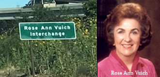 The Route 41/Route 180 interchange (~ FRE R58.661) s named the "Rose Ann
Vuich" Interchange. Rose Ann Vuich was the state senator that
secured the funding for completion of Route 41 and Route 180. Rose Ann
Vuich was elected to the Senate in 1976 to represent the 15th Senate
District, comprised of Tulare and Kings Counties, approximately half of
Fresno County, and a portion of Kern County. She was born in January 1927,
in Cutler, California, and wa sa lifetime resident of Tulare County. Not
many initially took notice when she ran for a vacant state Senate seat in
1976, as the area voted Republican in most elections. However, she scored
one of the biggest upsets in the state that year when she narrowly
defeated Ernest Mobley, a 10 year Republican Assemblyman, in the general
election. Vuich quickly became popular in her district for her unassuming
manner and her political independence. She broke with her party on
agricultural and law enforcement issues on several occasions. Her
Democratic colleagues tolerated that because of the conservative
constituency she represented. However, she was willing to stand up to
conservatives, angering popular Republican Governor George Deukmejian in
1989 when she voted against confirming his chosen appointee for state
Treasurer when the post became vacant. Rose Ann Vuich was the first woman
elected to the California Senate; and served with distinction on the
Senate Transportation Committee, the Senate Rural Caucus, and as chair of
the Senate Select Committee on Rural Issues. Her role in transportation
and rural issues led her to being an active supporter of the construction
of the Fresno County portions of Route 41, the southern gateway to
Yosemite National Park, and Route 180, the gateway to Sequoia and Kings
Canyon National Parks. Studies to construct both freeways began in 1955
and construction of the first portion of Route 41 began in 1970. In 1976,
the funding for the completion of those freeways was uncertain; and as a
Senator, Rose Ann Vuich championed "constructing the road that leads to
nowhere to the road that leads to somewhere". Additionally, Rose Ann Vuich
used her leadership skills to secure funding for the completion of the
construction of Route 41 and Route 180; and the routes were reopened to
traffic on September 20, 1982. Named by Senate Concurrent Resolution 25,
Chapter 85, in 1997.
The Route 41/Route 180 interchange (~ FRE R58.661) s named the "Rose Ann
Vuich" Interchange. Rose Ann Vuich was the state senator that
secured the funding for completion of Route 41 and Route 180. Rose Ann
Vuich was elected to the Senate in 1976 to represent the 15th Senate
District, comprised of Tulare and Kings Counties, approximately half of
Fresno County, and a portion of Kern County. She was born in January 1927,
in Cutler, California, and wa sa lifetime resident of Tulare County. Not
many initially took notice when she ran for a vacant state Senate seat in
1976, as the area voted Republican in most elections. However, she scored
one of the biggest upsets in the state that year when she narrowly
defeated Ernest Mobley, a 10 year Republican Assemblyman, in the general
election. Vuich quickly became popular in her district for her unassuming
manner and her political independence. She broke with her party on
agricultural and law enforcement issues on several occasions. Her
Democratic colleagues tolerated that because of the conservative
constituency she represented. However, she was willing to stand up to
conservatives, angering popular Republican Governor George Deukmejian in
1989 when she voted against confirming his chosen appointee for state
Treasurer when the post became vacant. Rose Ann Vuich was the first woman
elected to the California Senate; and served with distinction on the
Senate Transportation Committee, the Senate Rural Caucus, and as chair of
the Senate Select Committee on Rural Issues. Her role in transportation
and rural issues led her to being an active supporter of the construction
of the Fresno County portions of Route 41, the southern gateway to
Yosemite National Park, and Route 180, the gateway to Sequoia and Kings
Canyon National Parks. Studies to construct both freeways began in 1955
and construction of the first portion of Route 41 began in 1970. In 1976,
the funding for the completion of those freeways was uncertain; and as a
Senator, Rose Ann Vuich championed "constructing the road that leads to
nowhere to the road that leads to somewhere". Additionally, Rose Ann Vuich
used her leadership skills to secure funding for the completion of the
construction of Route 41 and Route 180; and the routes were reopened to
traffic on September 20, 1982. Named by Senate Concurrent Resolution 25,
Chapter 85, in 1997.
(Image source: Gribblenation; Find a Grave)
 The Rout 180 interchange at Fowler Avenue in the City of Fresno (~ FRE R63.905) is named the “Kimberly Marie Hamilton Memorial Interchange”.
It was named in memory of Kimberly Marie Hamilton, born August 14, 1987,
in Fresno, California. She attended Clovis East High School in Fresno,
California, and was an avid golfer and hockey fan. Kimberly spoke often of
becoming a teacher, and was loved and respected by family and friends. On
May 7, 2004, Kimberly was the victim of a car accident that occurred on
Fowler Avenue near Belmont Avenue in the City of Fresno under tragic
circumstances involving a construction vehicle. Her death has affected and
touched many people's lives, and has increased the call for better safety
practices in and around roadway construction sites. Named by Assembly
Concurrent Resolution (ACR) 139, Resolution Chapter 136, on 9/5/2008.
The Rout 180 interchange at Fowler Avenue in the City of Fresno (~ FRE R63.905) is named the “Kimberly Marie Hamilton Memorial Interchange”.
It was named in memory of Kimberly Marie Hamilton, born August 14, 1987,
in Fresno, California. She attended Clovis East High School in Fresno,
California, and was an avid golfer and hockey fan. Kimberly spoke often of
becoming a teacher, and was loved and respected by family and friends. On
May 7, 2004, Kimberly was the victim of a car accident that occurred on
Fowler Avenue near Belmont Avenue in the City of Fresno under tragic
circumstances involving a construction vehicle. Her death has affected and
touched many people's lives, and has increased the call for better safety
practices in and around roadway construction sites. Named by Assembly
Concurrent Resolution (ACR) 139, Resolution Chapter 136, on 9/5/2008.
(Image sources: Gribblenation/Tom Fearer, Find a Grave)
 The intersection at Route 180 and Temperance Avenue (FRE
R65.35) in the County of Fresno is named the Officer Phia Vang
Memorial Interchange. Officer Phia Vang was born in August 1970 in
Ban Phakke, Mouang Phoun, Vangvieng province in the country of Laos, to
Xay Pao Vang (father) and Mee Her (mother); Officer Vang was the youngest
of nine children and has four brothers and four sisters. After the Secret
War in Laos ended in 1975, Phia, at five years of age, fled into the
jungle of Laos with his father, mother, and two sisters to escape the new
communist regime; during their passage to Thailand, both parents and a
sister suffered gunshot wounds; though his mother and father survived
their injuries, his sister was fatally wounded and had to be left behind.
After crossing the Mekong River to Thailand, Phia, his older sister, and
their parents found refuge in the Ban Vinai Refugee Camp, where they lived
for one year; they were then sponsored to Denver, Colorado, in April 1980,
and once in Denver, they were finally reunited with immediate and extended
family members. In 1982, the Vang family decided to relocate to Fresno,
California, where their hardworking parents became farmers and contributed
to the local agricultural business. Phia attended Yosemite Middle School
and graduated from McLane High School in 1989; regardless of the language
barrier and cultural differences, he was still determined to be
successful. Driven by his willpower and passion to serve the community,
Phia enrolled in the Fresno City Police Academy and completed his training
in 1991. Phia was first appointed as a Reserve Police Officer in 1992 and
was eventually hired by the Fresno Police Department in 1993, where he was
assigned to the Multi-Agency Gang Enforcement Consortium, Northwest
District Neighborhood Patrol, and the Fresno Area Express Unit. Officer
Vang was a dedicated police officer in the Fresno Police Department for 26
years and was known by his colleagues as someone who was humble with a
great sense of humor. Officer Vang left behind family members, fellow
officers, and friends on Monday, February 4, 2019, due to an intoxicated
driver colliding with his vehicle. Named by Assembly Concurrent Resolution
97, Res. Chapter 35, 9/14/2020)
The intersection at Route 180 and Temperance Avenue (FRE
R65.35) in the County of Fresno is named the Officer Phia Vang
Memorial Interchange. Officer Phia Vang was born in August 1970 in
Ban Phakke, Mouang Phoun, Vangvieng province in the country of Laos, to
Xay Pao Vang (father) and Mee Her (mother); Officer Vang was the youngest
of nine children and has four brothers and four sisters. After the Secret
War in Laos ended in 1975, Phia, at five years of age, fled into the
jungle of Laos with his father, mother, and two sisters to escape the new
communist regime; during their passage to Thailand, both parents and a
sister suffered gunshot wounds; though his mother and father survived
their injuries, his sister was fatally wounded and had to be left behind.
After crossing the Mekong River to Thailand, Phia, his older sister, and
their parents found refuge in the Ban Vinai Refugee Camp, where they lived
for one year; they were then sponsored to Denver, Colorado, in April 1980,
and once in Denver, they were finally reunited with immediate and extended
family members. In 1982, the Vang family decided to relocate to Fresno,
California, where their hardworking parents became farmers and contributed
to the local agricultural business. Phia attended Yosemite Middle School
and graduated from McLane High School in 1989; regardless of the language
barrier and cultural differences, he was still determined to be
successful. Driven by his willpower and passion to serve the community,
Phia enrolled in the Fresno City Police Academy and completed his training
in 1991. Phia was first appointed as a Reserve Police Officer in 1992 and
was eventually hired by the Fresno Police Department in 1993, where he was
assigned to the Multi-Agency Gang Enforcement Consortium, Northwest
District Neighborhood Patrol, and the Fresno Area Express Unit. Officer
Vang was a dedicated police officer in the Fresno Police Department for 26
years and was known by his colleagues as someone who was humble with a
great sense of humor. Officer Vang left behind family members, fellow
officers, and friends on Monday, February 4, 2019, due to an intoxicated
driver colliding with his vehicle. Named by Assembly Concurrent Resolution
97, Res. Chapter 35, 9/14/2020)
(Image source: ABC 30 Action News)
 National Trails
 Portions of this route appear to have been part of the "National Park to Park Highway".
 Scenic Route
[SHC 263.7] From Route 65 near Minkler to General Grant Grove section of Kings Canyon National Park.
Freeway[SHC 253.7] Entire portion. Added to the Freeway and Expressway system in 1959.
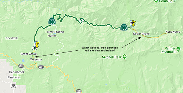 From the General Grant Grove section of the Kings Canyon National Park to the
Kings Canyon National Park boundary near Cedar Grove.
From the General Grant Grove section of the Kings Canyon National Park to the
Kings Canyon National Park boundary near Cedar Grove.
Post 1964 Signage HistoryIn 1963, this segment was defined as “(d) The General Grant Grove section of Kings Canyon National Park to Kings River Canyon.”
In 1984, Chapter 409 clarified this segment to be “(d) The General
Grant Grove section of Kings Canyon National Park to Kings Canyon
River Kings Canyon National Park boundary near Cedar Grove.”
Pre 1964 Signage HistoryAs noted by Tom Fearer in the Gribblenation Blog "California State Route 180 east of Fresno to Cedar Grove (Kings Canyon Highway)", the history of the State Highway System in the Kings Canyon region began in 1905 when Legislative Chapter 598 ordered
"locating, surveying, and constructing a public highway from the General
Grant National Park in Fresno County, thence E-ly into Kings Canyon".
Interests in a State Highway from General Grant National Park east to the
floor of Kings Canyon seem to have been spurred by the Sanger Lumber
Company (the 1892 renaming of the Kings River Lumber Company). In 1909,
Legislative Chapter 223 the State authorized that "The highway now
completely located and surveyed, and partially completed ... from the
General Grant National Park to the floor of the Kings River Canyon is
hereby made a state highway." Legislative Chapter 223 effectively assumed
control of a partially built road from General Grant National Park to the
floor of Kings Canyon. The Kings River Highway was funded as part of the
1919 Third State Highway Bond Act when it came to be known as LRN 41. The
1920 Division of Highways Map shows the planned route of LRN 41 extended
east all the way to the Kings River near Boyden Caverns. LRN 41 is shown
to be a 1919 Bond Act Road and Special Appropriations Road. The existing
highway from General Grant National Park towards Hume Lake Road is stated
to have followed the eastern bank of Indian Creek from Cherry Gap which is
now Forest Road 13S48. The Kings River Highway is cited to have a planned
terminus at Copper Creek in Cedar Grove.
(Source: Gribblenation Blog (Tom Fearer) "California State Route 180 east of Fresno to Cedar Grove (Kings Canyon Highway)")
The 1934 State Highway map showed the route completed to the Kings River;
sometime between 1934 and 1940, it was extended E to Cedar Grove. E of
Squaw Valley, it appears that Dunlap Road is a former routing of Route 180
prior to 1942. At the time, Route 65 (later renumbered Route 69 and then
Route 245) terminated at Dunlap Road. An early Division of Highways Map
shows state maintenance ending at an eastern terminus of the 1933 Kings
River Bridge and not near Cedar Grove in 1935. State highway maps from
1938 show that the route was still being built to Cedar Grove. Between
1940 and 1942, Route 180 was moved to its current alignment, and the
terminus of Route 65 was adjusted.
(Source: Tom Fearer at AARoads, April 2017; Mom Fearer at Gribblenation 5/4/2017)
Note: Hume Lake and the road of the same name, in the vicinity of Route 180, are both very old which is why they show on the 1935 Fresno County
Map as County Maintained. Hume Lake was formed by the impounding of Ten
Mile Creek in 1908 which was used as a logging storage reservoir. The dam
that contains Hume Lake is a multiple arch concrete dam. The logging flume
that went to Sanger was 73 miles in length as well, essentially it played
a large factor in drawing what became Route 180 east of General Grant
National Park. Logging stopped in 1924 but Hume Lake and reservoir were
purchased by the Forest Service in 1935. Hume Lake Road was on the 1918
State Highway Map where it is listed as special appropriations road from
General Grant National Park to Hume Lake. The 1930 State Highway Map is
the first to show a complete but yet unimproved highway to Hume Lake with
a further implied extension into Kings Canyon being shown that would
become the eastern segment of Route 180.
(Source: Tom Fearer on AARoads, May-June 2017)
In 1934, Route 180 was (to be) signed along the route from Jct Route 25 at Pacines to Jct. Route 7 (US 395) at Independence, via Fresno. Oddly, it was part of a 1959 extension of LRN 41, so it is unclear why it was signed in 1934. Additionally, the signed route continued E from the current terminus across the mountain (routing not determined) to Route 7 (US 395) in Independence. That portion of the route doesn't correspond to anything in the state highway system prior to 1934... or even since. Again, "Tis a puzzlement."
Tom Fearer notes, regarding the extension to Route 7 (US 395):
(Source: Gribblenation Blog (Tom Fearer) "California State Route 180 east of Fresno to Cedar Grove (Kings Canyon Highway)")
The original Sign State Route definition of Route 180 announced in the August 1934 California Highways & Public Works shows that it was intended to cross the Sierra Nevada Mountains to an eastern terminus at Independence via Kings Canyon and Kearsarge Pass. Route 180 would have used LRN 41 east from Fresno into Kings Canyon, but from Kearsarge Pass it's planned route did not match any planned State Highway. The October 1931 California Highways & Public Works discusses a reconnaissance trip of the South Fork Kings River Basin via Kearsarge Pass, Bullfrog Lake, and Junction Meadow to survey snow courses. The article elaborates further by stating a cooperative survey between the Division of Highways and Forest Service was in the works to survey a route for a new highway through what are now Sequoia National Forest and Inyo National Forest. Despite Route 180 clearly being intended in it's original definition to reach Independence the definition of LRN 41 was never extended east of Kings Canyon. This implies that any road from the Kings Canyon east over Kearsarge Pass to Independence would have been maintained by the Forest Service and Inyo County. Regardless several early Sign State Route era maps show Route 180 existing from near Kearsarge Pass east via Onion Valley Road to Independence (note; early Sign State Routes were signed by the Auto Clubs and not restricted to State Maintained Highways). Route 180 can be clearly seen on Onion Valley Road along with the planned connecting route over the Sierra Nevada Mountains to the Kings River Canyon on the 1935 Goshua Highway Map of California.
The John Muir Wilderness was established in 1964 which enhanced protections over existing National Forest Lands. The John Muir Wilderness was enabled by the Wilderness Act of 1964 which largely sought to stop highway development in the Sierra Nevada Mountains. The John Muir Wilderness largely seems to have been an attempt to stop numerous planned Trans-Sierra Highways as it's boundaries cover the planned routes of:
StatusIn October 2023, the CTC amended the following project into the SHOPP:
06-Fre-180 117.9/137.94. PPNO 06-8089; ProjID 0624000029; EA 1G330. Route 180 Near Cedar Grove, from 1.0 mile east of Hume Lake Road to end of Route 180 at Kings Canyon National Park. Repair storm damaged washouts,
reconstruct roadway, construct retaining walls, reconstruct slope, restore
drainage systems, rebuild guardrail, remove debris, and install a
temporary bridge for detour. Note: Severe weather events in February and
March 2023 caused multiple slipouts, mudslides, rock slides, and complete
washouts of the roadway creating a road closure from Hume Lake to Boyden
Cavern. The amount of damage has caused delays in getting topographic
surveys conducted and geotechnical boring operations started in order to
gather the geotechnical recommendations. The delay in preliminary
investigations has caused the delay in determining the scope, cost, and
schedule needed for this project. The Department forces recently blasted
rock to gain access for further analysis and investigations to continue.
This project will reconstruct the roadway up to PM 128.1 for reopening the
roadway including the installation of a temporary bridge to extend access
from PM 128.1 to the end of the project limits. Geotechnical
investigations will continue after the reopening. Allocation ($ ×
1,000): PA&ED $0; PS&E $0; R/W Sup $5; Con Sup $3,750; R/W Cap
$20; Const Cap $25,480; TOTAL $29,255.
(Source: October 2023 CTC Agenda, Agenda Item 2.1a.(1a) #19)
Naming Scenic Route[SHC 263.7] Entire portion.
National Trails Portions of this route were part of the National Park to Park Highway.
 Exit Information Post 1964 Signage History
 Around 1985, the number I-180 was briefly proposed for the
Richmond-San Rafael stretch of what is now I-580 and was formerly part of
CA 17.
Around 1985, the number I-180 was briefly proposed for the
Richmond-San Rafael stretch of what is now I-580 and was formerly part of
CA 17.
 Other WWW Links
 Classified Landcaped Freeway
The following segments are designated as Classified Landscaped Freeway:
| County | Route | Starting PM | Ending PM |
| Fresno | 180 | R55.84 | R56.30 |
| Fresno | 180 | R56.30 | R56.78 |
| Fresno | 180 | R56.84 | R57.47 |
| Fresno | 180 | R57.60 | R60.86 |
| Fresno | 180 | R60.86 | R63.44 |
 Interstate Submissions
Around 1985, the number I-180 was briefly proposed for the Richmond-San Rafael stretch of what is now I-580 and was formerly part of Route 17.
In 1958, the California Department of Highways proposed the designation I-180 for what is now I-280.
 Interregional Route
[SHC 164.18] Between the east urban limits of Fresno and Kings Canyon National Park.
 Statistics
Overall statistics for Route 180:
 Pre-1964 Legislative Route
In 1933, the route from "[LRN 2] near Orange County Hospital northerly to Hermosa Beach-Santa Ana Canyon Road" was defined as part of the state highway system. In 1935, this was added to the highway code as LRN 180, with the routing:
"[LRN 2] near Orange County Hospital northerly to [LRN 175]"
This route ran from US 101 near Orange County Hospital (now the Western Medical Center, Anaheim) northerly to Orangethorpe Ave (US 91). This is close to the present-day routing of Route 57; however, the specific definition for LRN 180 corresponds to 1964-1981 Route 250. It ran along Placentia Ave, which was renamed sometime after 1959 to State College Boulevard, and was eliminated as a state highway when Route 57 was completed.
© 1996-2020 Daniel P. Faigin.
Maintained by: Daniel P. Faigin
<webmaster@cahighways.org>.
 Route 179
 Route 181