
 California Highways:
Click here for a key to the symbols used. An explanation of acronyms may be found at the bottom of the page.
 Routing
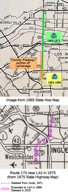
From Los Angeles International Airport to Route 90.
 Post 1964 Signage History
▸As defined in 1963, this segment was defined as "(a) Route 405 near Inglewood to Route 101 in Los Angeles."
▸In 1965, Chapter 1372 changed the origin of this segment to "(a) Route 405 Los Angeles International Airport to Route 101 in Los Angeles."
▸In 1968, Chapter 282 corrected the typo: "(a) Route 405
Los Angeles International Airport to Route 101 in Los Angeles."
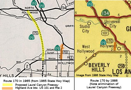
 In 1970, the Los Angeles Times presented a map showing the alternatives under
consideration for the Route 170 Freeway. This was part of an article
reporting on a call to halt route studies for the route by the LA City
Council. The complaint was that the freeway would take some of the most
choice and scenic hillside lands. There were also strong efforts to avoid
Beverly Hills.
In 1970, the Los Angeles Times presented a map showing the alternatives under
consideration for the Route 170 Freeway. This was part of an article
reporting on a call to halt route studies for the route by the LA City
Council. The complaint was that the freeway would take some of the most
choice and scenic hillside lands. There were also strong efforts to avoid
Beverly Hills.
▸In 1971, Chapter 1398 split this segment: "(a) Los Angeles International Airport to Route 90. (b) Route 2 to Route 101 in Los Angeles." Note that this definition deleted the portion between Route 90 (Slauson Blvd) and Route 2 (Santa Monica Blvd).
▸In 2015, Chapter 451 (10/2/2015) deleted this segment from the definition.
 Pre 1964 Signage History
This was part of LRN 160, defined in 1933 (the portion from LAX to I-405 is post-1964 routing).
Originally, this segment continued N from Route 90 approximately along La Cienega and Crescent Heights to Santa Monica Blvd. This was LRN 160, defined in 1933.
The Laurel Canyon Freeway had been in the plans since at least 1961. An
article in the LA Times in December 1961 showed a proposed Laurel Canyon
Freeway running from US 101 S towards LAX, corresponding to what would be
shown on the 1965 state highway map.
(Source: Los Angeles Times, 12/17/1961 via Joel
Windmiller, 1/18/2023, and other sources)
 Status
 Unsigned; unconstructed. Caltrans has no plans to adopt the route. However, it does show up in the CalTrans Routelog in 2001. The
traversable local routing was identified as La Tijera Blvd and La Cienega
Blvd.
Unsigned; unconstructed. Caltrans has no plans to adopt the route. However, it does show up in the CalTrans Routelog in 2001. The
traversable local routing was identified as La Tijera Blvd and La Cienega
Blvd.
The 2013 Traversable Highways report notes this is La Tijerra Blvd., La Cienega Blvd. From LAX to I-405 added to F&E System 9/17/65. Deleted in 2015.
It appears that a small segment of this may have been constructed to freeway standards--the segment of La Cienega Blvd between Centinela (Route 107) and Rodeo Road. In 1953, it was reported in CHPW that "Los Angeles County recently opened to traffic a section of expressway from roughly Stocker Street to Jefferson Boulevard, which now extends this expressway from the City of Inglewood to Jefferson Boulevard in the general route indicated on the map for the Crenshaw Freeway." That segment was designed, constructed, and financed by the Los Angeles Dept. of Public Works for $2 million.
The "La Cienega Freeway" portion is now an expressway maintained by the county of Los Angeles. At least one map dating from the late 1950's show this as part of the future Route 170 freeway. For more history, see the information for LRN 160 and the information about the 1955 proposal for the La Cienega Freeway. It is also clear that the I-405 interchange with La Cienega was constructed to be a future Route 170 interchange: this is clear from the construction of the off-ramps and on-ramps.
 Naming
This segment was to have been named the "Skyway Freeway". It was named by Assembly Concurrent Resolution 109, Chapter 26, in 1974. The name derives from the fact the route was meant to go to the Los Angeles Airport.
It is also referred to as the La Cienega Freeway. La Cienega is actually a misspelling of the Spanish word "cienaga", meaning "marsh" or "swamp." The misspelling began with the name of the local ranch. The name might refer to the wetlands originally near the airport.
 Other WWW Links
 Freeway
[SHC 253.7] Entire portion (unconstructed). Added to the
Freeway and Expressway system in 1959. The portion from LAX to I-405 was
added to the Freeway and Expressway system on 9/17/1965. This entire
segment was deleted from the Freeway and Expressway System in 2015 by SB
491, Chapter 451, 10/2/2015.
Route 2 to Route 101 in Los Angeles.
(b) The relinquished former portion of Route 170 within the City of Los Angeles between Route 2 and Route 101 is not a state highway and is not eligible for adoption under Section 81. For that relinquished former portion of Route 170, the City of Los Angeles shall maintain signs directing motorists to the continuation of Route 170.
Post 1964 Signage HistoryThis segment was part of the original definition of segment (a) in 1963.
In 1964, the CHC adopted 0.4 mile of Vineland Avenue in Los Angeles between the Hollywood Freeway and Lankershim Boulevard as Route 170. In a related action, the CHC relinquished the portion of Lankershim Boulevard between the Hollywood Freeway and Vineland Avenue, formerly part of Route 170, to the city.
In 1971, Chapter 1398 split (a), creating this segment: "(a) Los Angeles International Airport to Route 90. (b) Route 2 to Route 101 in Los Angeles."
AB 3047, Chapter 650, 9/21/2004, permitted the California Transportation Commission to relinquish to the City of Los Angeles this segment of Route 170 pursuant to the terms of a cooperative agreement between the city and the department, upon a determination by the commission that the relinquishment is in the best interests of the state. Such a relinquishment becomes effective immediately following the recordation by the county recorder of the relinquishment resolution containing the commission's approval of the terms and conditions of the relinquishment. At that point, the portion of Route 170 relinquished under this subdivision shall cease to be a state highway, and cannot be considered for future adoption. This segment was up for relinquishment in November 2005.
In May 2007, the LA Department of Public Works issued a press release that noted the Route 170 was under city jurisdiction, as well as acknowledging the receipt of $3.2 million from Caltrans for future street and traffic improvements on the formerly State-owned portion of Highland Avenue. The Department of Public Works Bureau of Engineering (BOE) will take the lead in the design and construction management of future street improvements to ease traffic along the relinquished portion of Highland Avenue, stretching northbound from Santa Monica Boulevard to US 101. This will permit the city to make needed improvements. These improvements include adjusting lane widths to City standards for optimized use of the street’s surface and synchronization of street signals to relieve traffic congestion along the Highland corridor. Transfer of jurisdiction over the thoroughfare to the city also gives way to the highly anticipated Highland-Franklin Intersection Improvement Project, which will widen streets and add right-turn pockets to the intersection of Highland and Franklin to mitigate traffic in the area for commuters and local residents. The project includes the installation of 45 new streetlights, 29 street trees, 30 decorative pedestrian lights and new traffic signals along Highland and Franklin avenues. Construction of the project is expected to begin in late May 2006, under a 6-month contract awarded to Excel Paving. In addition to Highland Avenue, the relinquished area includes Cahuenga Boulevard East, just north of Pilgrimage Bridge to Odin Street; Cahuenga Boulevard West, just north of Pilgrimage Bridge to Hollywood Bowl Road; and Odin Street from Cahuenga Boulevard eastbound to Highland Avenue. There exist a number of streets in the City of Los Angeles currently under State ownership due to their original purpose as direct connectors to State highways.
In 2010, SB 1318, Chapter 421, 9/29/10, changed the start of this
segment: "Route 2 Route 101 near Riverside Drive
to...", essentially deleting the portion in the Hollywood Hills.
Pre 1964 Signage HistoryThis was a constructed portion of LRN 160, defined in 1933. There was also an unconstructed portion that ran along Crescent Heights/Laurel Canyon Blvd between Santa Monica and US 101 (in the San Fernando Valley). This was never constructed, although it remained proposed for a long time.
NamingHad the freeway routing been constructed, it would have been named the "Laurel Canyon Freeway". Maps based on the 1956 freeway planning maps show this as continuing N from US 101 to I-5, joining at what would have been a hell-of-an-interchange: the Laurel Canyon freeway, the Sunland Freeway (see Route 64), the Hollywood Freeway (present-day Route 170), Golden State Freeway (I-5). Laurel Canyon refers to the canyon in Hollywood Hills; the portion in the flats was originally called Pacoima Avenue.
StatusThe route ran along Cahuenga, and thence upon Highland to Santa Monica Blvd. Cahuenga is an Indian name, probably derived from the name of a local Indian village. The routing was originally planned as freeway in 1965 but never constructed, along a routing that followed Laurel Canyon. Some map books indicate the route as signed, but no one has reported signs. If you look closely at the bridge marker at Caheunga and US 101, you will see it is signed as the Route 170/Route 101 junction. There are also two reassurance signs: One is southbound just south of the Hollywood Bowl, while the other is northbound at either Hollywood or Sunset.
 From Route 101 near Riverside Drive to Route 5 near Tujunga Wash.
Post 1964 Signage HistoryIn 1963, this was originally defined as "(b) Route 101 near Riverside Drive to Route 5 near Tajunga Wash.". Chapter 1698 later that year corrected the spelling.
The following freeway-to-freeway connections were never constructed:
SB Route 170 to NB US 101. Rationale: Construction orf this connector was put "on hold" pending completion of the interchange for the Laurel Canyon Freeway (Route 170), which ended up never being constructed.
Michael Ballard's site notes that US 6 was originally signed on the southern end of Route
170 (near Vineland) when it was first constructed, and that the original
plans were to run US 6 down Route 170 and US 101. However, when US 6 was
truncated in 1963, any further signage stopped. Michael's site shows
signage at the interchange with US 101 and Route 134, and a bit N of that
interchange.
(Source: Michael Ballard (SDMichael) on AARoads, "US 6 and the Hollywood Freeway", 4/22/2013; Michael Ballard via Email, 7/16/2020)
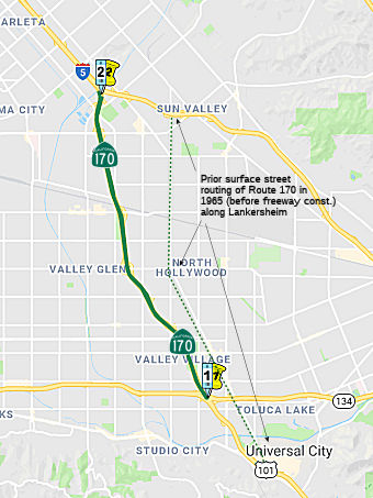
In September 1966, a two mile extension of Route 170 between Magnolia and
Victory opened. The cost was $5.9 million.
(Source: CHPW, Jan/Feb 1967)
Pre 1964 Signage HistoryThis was LRN 159, defined in 1933. Before the construction of the freeway, the route ran along Lankershim Blvd. It was unsigned before construction of the freeway (although one map shows it as being signed Route 159, which may be an error). Lankershim Boulevard was named for the town of Lankershim (first called Toluca, now North Hollywood) and its founding family. Isaac B. Lankershim grew wheat in a wide swath of the Valley.
 In 1952, the CHC adopted a freeway routing for the
Hollywood Freeway extension. The extension used rights of way along the
Tujunga Wash flood control project, as was referred to as State Highway
Route (i.e., LRN) 159.
In 1952, the CHC adopted a freeway routing for the
Hollywood Freeway extension. The extension used rights of way along the
Tujunga Wash flood control project, as was referred to as State Highway
Route (i.e., LRN) 159.
(Source: Los Angeles Times, 6/13/1952, via Joel Windmiller,
2/26/2023)
Naming The segment of Route 170 from the US 101/Rout 134/Route 170 junction to the Route 5 junction (~ LA R14.644 to LA
R20.374) is named the "Hollywood Freeway".
The segment of Route 170 from the US 101/Rout 134/Route 170 junction to the Route 5 junction (~ LA R14.644 to LA
R20.374) is named the "Hollywood Freeway".
(Image source: Gribblenation)
 The interchange of the U 101, Route 134, and Route 170 freeways (~LA R14.644) is named the "Bruce
T. Hinman Memorial Interchange." Officer Bruce T. Hinman was on
routine motorcycle patrol on Route 170 at US 101 when he stopped to assist
a disabled motorist. A drunk driver traveling at 60 m.p.h. along US 101
attempted to change routes by driving over a raised berm, then across the
freeway and onto the dirt shoulder where he crashed into the disabled
vehicle. The impact spun the disabled vehicle around, striking the
motorist, who was using the freeway call box, and knocking Officer Hinman
to the ground. The car came to rest with its rear wheels on top of the
officer's chest, suffocating him. Officer Hinman, 34, was placed on life
support but died a week later. He was a nine-year member of the CHP and
was assigned to the West Valley Area office directly after graduating from
the Academy. CHP Officer Bruce Hinman, an eight-year CHP veteran, was said
to be the first officer in the 26-year history of the patrol's West Valley
station to die in the line of duty.
The interchange of the U 101, Route 134, and Route 170 freeways (~LA R14.644) is named the "Bruce
T. Hinman Memorial Interchange." Officer Bruce T. Hinman was on
routine motorcycle patrol on Route 170 at US 101 when he stopped to assist
a disabled motorist. A drunk driver traveling at 60 m.p.h. along US 101
attempted to change routes by driving over a raised berm, then across the
freeway and onto the dirt shoulder where he crashed into the disabled
vehicle. The impact spun the disabled vehicle around, striking the
motorist, who was using the freeway call box, and knocking Officer Hinman
to the ground. The car came to rest with its rear wheels on top of the
officer's chest, suffocating him. Officer Hinman, 34, was placed on life
support but died a week later. He was a nine-year member of the CHP and
was assigned to the West Valley Area office directly after graduating from
the Academy. CHP Officer Bruce Hinman, an eight-year CHP veteran, was said
to be the first officer in the 26-year history of the patrol's West Valley
station to die in the line of duty.
(Image source: Flikr, Officer Down Memorial Page)
StatusAlthough the route does not end at the US 101 junction, there is an "END Route 170" sign at that point.
In August 2022, it was reported that Metro and Caltrans have announed the
completion of 5.4 miles of new sound walls along Route 170 and I-405 in
the North Hollywood area of Los Angeles. The new $103-million sound wall
project provides freeway noise relief to the residents of North Hollywood,
Valley Glen and Valley Village. Sound walls were completed specifically
along Route 170 from US 101 (~ 07-LA-170 R14.649) to Sherman Way (~
07-LA-170 R18.277), and along I-405 from Saticoy Avenue (~ 07-LA-405
42.883) to Roscoe Boulevard (~ 07-LA-405 43.781). The project also
included the widening of eight bridges to support the sound walls without
widening the lanes. Construction of this sound wall project began in 2017
and as of August 2022 was substantially complete. The project team will
later add landscaping to help stabilize the slopes and beautify the
right-of-way. Plantings are expected to be completed by fall 2023. New
sound walls were funded by Metro’s 2008 voter-approved Measure R
transportation sales tax measure as well as Proposition C that was passed
by county voters in 1990. What is interesting about this project is that
it was primarily a Metro project, not Caltrans. With the passage of Senate
Bill (SB)-45, the California Street and Highway Code was amended to
transfer the programming and funding responsibilities of the Post 1989
Soundwall Retrofit Program to Regional Transportation Planning Agencies.
In LA County, Metro assumed this responsibility. However, the
eligibility determination as well as design and construction
responsibilities for the program remained with the California Department
of Transportation (Caltrans). Metro inherited a backlog of soundwall
projects totaling nearly $1 billion without any corresponding funding from
the state.
(Source: Metro "The Source" 8/4/2022, Metro "Highway Soundwalls" 9/17/2022)
 Commuter Lanes
Commuter lanes exists between Route 101 and Route 5. These were opened in February 1996, require two or more occupants, and are always in operation.
Freeway[SHC 253.7] Entire portion. Added to the Freeway and Expressway system in 1959.
 Classified Landcaped Freeway
The following segments are designated as Classified Landscaped Freeway:
| County | Route | Starting PM | Ending PM |
| Los Angeles | 170 | 14.50 | 20.55 |
 Exit Information
The constructed portion of Route 170 begins at PM 9.2; hence, exit numbers will be approximately 9 less that the corresponding PMs.
Other WWW Links Post 1964 Signage HistoryUntil 1968, Route 170 was a continuous route from Route 405 to Route 101 (the Laurel Canyon Freeway; LRN 160), and from Route 101 to Route 5 (Hollywood Freeway route; LRN 159). In 1968, the portion from the Los Angeles International Airport to Route 405 was added. In 1971, the discontinuities between (1) and (2) were introduced.
Pre 1964 Signage HistorySigned Route 170 was not defined as part of the initial state signage of routes in 1934. It is unclear what (if any) route was signed as Route 170 between 1934 and 1964.
 Statistics
Overall statistics for Route 170:
 Pre-1964 Legislative Route
In 1933, Chapter 767 defined the route from "Long Beach-Santa Ana Road near Seal Beach via Santa Fe Springs to [LRN 26] near West Covina". In 1935, this was added to the highway code as LRN 170 with the routing:
"[LRN 179] near Seal Beach via Santa Fe Springs to [LRN 26] near West Covina"
In 1957, Chapter 36 extended the route to originate at [LRN 60]: "[LRN 179] [LRN 60] near Seal Beach to …"
In 1959, Chapter 1062 the route from US 70 to US 66, terminating at "[LRN 9] near Duarte."
This route ran from Route 1 near Seal Beach to I-210 near Duarte. This is former Route 35; it is present-day I-605. The portion between Route 1 and I-405 was Route 240 between 1964 and 1968.
© 1996-2020 Daniel P. Faigin.
Maintained by: Daniel P. Faigin
<webmaster@cahighways.org>.
 Route 169
 Route 171