
 California Highways:
Click here for a key to the symbols used. An explanation of acronyms may be found at the bottom of the page.
 Routing
 Post 1964 Signage History
The definition of this route remains unchanged from 1963.
 In April 1965, a 17 mile alignment for Route 56 was adopted. It took a while for construction to be
started. There were environmental challenges through much of the 1980s and
early 1990s. The first segment of Route 56 to break ground was from
Black Mountain Road to I-15 on July 25, 1991, which opened in early
1993. After additional environmental challenges, construction of
Route 56 west of Black Mountain Road to I-5 near Del Mar broke ground
October 21, 1999 as a cooperative project between San Diego and
Caltrans. San Diego constructed the portion of Route 56 west of
Black Mountain Road to Carmel Mountain Road; with Caltrans constructing
the portion of from Carmel Mountain Road towards Carmel Creek Road and
I-5. This segment was completed on July 19, 2004.
In April 1965, a 17 mile alignment for Route 56 was adopted. It took a while for construction to be
started. There were environmental challenges through much of the 1980s and
early 1990s. The first segment of Route 56 to break ground was from
Black Mountain Road to I-15 on July 25, 1991, which opened in early
1993. After additional environmental challenges, construction of
Route 56 west of Black Mountain Road to I-5 near Del Mar broke ground
October 21, 1999 as a cooperative project between San Diego and
Caltrans. San Diego constructed the portion of Route 56 west of
Black Mountain Road to Carmel Mountain Road; with Caltrans constructing
the portion of from Carmel Mountain Road towards Carmel Creek Road and
I-5. This segment was completed on July 19, 2004.
(Source: Gribblenation Blog (Tom Fearer), "California State Route 56", 7/5/2023)
During construction of the Route 56 west to I-5 south flyover ramp in the
late 90’s, Caltrans closed the Sorrento Valley Road to both build
the flyover and use as a staging area for construction of the Route 56
freeway. Local environmentalists, homeowners, cyclists, etc.
campaigned to keep it closed, and when Dick Murphy ran for his ill-fated
mayorship in 2000, he made keeping the road closed a campaign platform.
Caltrans actually commissioned an EIR for slightly realigning and
reopening the road but abandoned it when local government opposed it.
(Source: Occidental Tourist on
AARoads, "Re: CA 56", 7/12/2023)
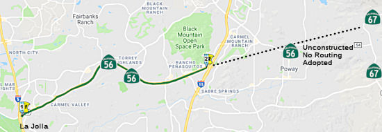
 The route is unconstructed from Route 15 to Route 67. There are
no current plans to construct a state highway in this segment. There is no
traversable highway identified. The 2013 Traversable Highways report notes
the route was adopted 4/28/65. There are no current plans to develop a
State Highway in this segment.
The route is unconstructed from Route 15 to Route 67. There are
no current plans to construct a state highway in this segment. There is no
traversable highway identified. The 2013 Traversable Highways report notes
the route was adopted 4/28/65. There are no current plans to develop a
State Highway in this segment.
 Pre 1964 Signage History
Before the 1964 renumbering, this route was LRN 278 (defined in 1959). LRN 278 was defined as “[LRN 2] north of La Jolla to [LRN 198]”. LRN 2 was US 101 (Future I-5), and LRN 198 was Route 67. The specific routing was determined, but the highway was unconstructed.
Sign Route 56 was not defined as part of the initial state signage of routes in 1934. It is unclear what (if any) route was signed as Sign Route 56 between 1934 and 1964.
 Status
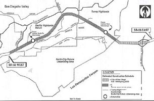 Constructed a fully access controlled freeway
from I-5 to I-15 (~ SD 0.000 to SD 9.471). This project was completed in
June 2004. The new constructed portion is a joy to drive, as its lightly
traveled, and still very much in a semi-rural state, save for a few retail
developments and some homes popping up in the distance. It appears there
is sufficient right of way for up to 10 lanes in the future. In July 2006,
the CTC considered modification of the project funding related to the
landscaping portion is currently under construction in 2006. TCRP funds,
the amount of $3,430,000, were set aside for a future traffic operations
project. However, costs to R/W have increased due to the final
condemnation case. The traffic operations project will be funded in a
future STIP cycle.
Constructed a fully access controlled freeway
from I-5 to I-15 (~ SD 0.000 to SD 9.471). This project was completed in
June 2004. The new constructed portion is a joy to drive, as its lightly
traveled, and still very much in a semi-rural state, save for a few retail
developments and some homes popping up in the distance. It appears there
is sufficient right of way for up to 10 lanes in the future. In July 2006,
the CTC considered modification of the project funding related to the
landscaping portion is currently under construction in 2006. TCRP funds,
the amount of $3,430,000, were set aside for a future traffic operations
project. However, costs to R/W have increased due to the final
condemnation case. The traffic operations project will be funded in a
future STIP cycle.
Route 5/Route 56 Connectors (SD 0.0/2.5)
There is not a connector from the NB I-5 to WB Route 56, and from SB I-5 to EB Route 56 (~ SD 0.035). According to an article in the San Diego Union-Tribune, motorists will be required to exit the freeway and use surface streets to make those transitions. This is because "Caltrans typically requires that 1,500 vehicles an hour pass through an interchange at peak travel times to necessitate a direct connector. Until recently, Caltrans contended that neither connection met that threshold. Moreover, the connectors would cost nearly $140 million. Caltrans spokesman Tom Nipper said spending $140 million to benefit 1,500 vehicles an hour didn't seem like a wise investment, so Caltrans and the San Diego Association of Governments decided to spend the region's limited transportation dollars on more pressing projects." Later meetings resulting in Caltrans updating its traffic projections and agreeing that the ramp connecting westbound 56 to northbound I-5 needs to be built before 2020. However, it still may take as long as 10 years to perform the necessary environmental studies, and design and build that segment. As for the ramp from SB I-5 to EB Route 56, the consensus was to put off construction of that ramp and concentrate on the west-to-north connector.
The SAFETEA-LU act, enacted in August 2005 as the reauthorization of TEA-21, provided the following expenditures on or near this route:
In San Diego: In July 2005, the CTC received a notice of EIR preparation for Route 5 and Route 56 in San Diego County that would provide a connector between Route 5 and Route 56 near Del Mar Heights (NOP). The alternatives being considered are:
In June 2012, Caltrans started soliciting
comments on the proposals. Options include building direct connectors
between the freeways, adding auxiliary lanes on I-5, doing a mix of both,
or doing nothing. The price tag to do something ranges from $95 million to
$250 million. Up to 27 homeowners' properties could be affected, but no
homes would be displaced entirely, according to Caltrans documents.
Caltrans is hoping to select an option by the end of this year so crews
can work concurrently with the I-5 corridor project. Construction will
begin when funding is available, likely sometime after 2020. For more than
10 years Caltrans, the San Diego Association of Governments and the city
of San Diego have been studying a proposed project to address mobility at
the interchange and conducting public workshops to create options. Visual,
noise and right-of-way impacts were the primary issues. Based on those
concerns, 17 alternatives were developed and all eventually but five were
eliminated. Of those, the first would connect westbound Route 56 to
northbound I-5 and southbound I-5 to eastbound Route 56 with two-lane,
freeway-to-freeway ramps that would add two lanes on westbound Route 56
and one lane on the eastbound side between Carmel Country Road and El
Camino Real at a cost of about $260 million. The second option adds an
auxiliary lane on southbound I-5 between Del Mar Heights and Carmel Valley
roads and includes improvements on westbound Route 56 for an estimated
cost of $100 million. The third proposal is a hybrid of the first two
plans, connecting westbound Route 56 to northbound I-5 with a two-lane,
freeway-to-freeway ramp. It adds an auxiliary lane on southbound I-5
between Del Mar Heights and Carmel Valley roads as well two lanes on
westbound Route 56 and one lane on eastbound Route 56 between Carmel
Country Road and El Camino Real for an estimated $170,000 million. Plan
four, called the hybrid with a flyover, connects westbound Route 56 to
northbound I-5 with a two-lane, freeway-to-freeway ramp. It includes a
connector ramp from eastbound Carmel Valley Road to eastbound Route 56 and
adds an auxiliary lane on southbound I-5 between Del Mar Heights and
Carmel Valley roads. This option would also add two lanes on westbound
Route 56 and one lane on eastbound Route 56 between Carmel Country Road
and El Camino Real, all at a cost of about $205 million to $225 million.
All proposed alternatives would replace and enhance the Del Mar Heights
Road overcrossing and include operational improvements at existing ramps
and intersections in the project area. Approximately $15.8 million has
been programmed for the project through federal and local funds. It is
included in TransNet, a voter-approved, half-cent tax for transportation
projects. If all goes as planned, construction would begin between 2020
and 2030 and take two years to complete. More information can be found at
KeepSanDiegoMoving.
(Source: The Coast News, 6/18/12)
In October 2017, the CTC approved for future consideration of funding the following project for which a Final Environmental Impact Report (FEIR) has been completed: I-5 and Route 56 in San Diego County. Construct roadway and interchange improvements on I-5 and Route 56 in and near the city of San Diego. (11-SD-5, PM R32.7/R34.8, 11-SD-56, PM 0.0/2.5) (EA 17790). This project proposes to provide direct connections between I-5 and Route 56 in San Diego County. This project is not fully funded and is included the San Diego Association of Governments 2016 Regional Transportation Improvement Program for $16.9 million, which includes local funding for preliminary engineering. The project will be constructed in multiple stages upon further programming. Construction is estimated to begin in 2020.
Route 56 Widening - El Camino Real to Carmel County Road (~ SD 0.32 to ~ SD 1.793)
 In August 2015, it was reported that the city of San
Diego and Caltrans are working together to find solutions for commuters
who struggle daily with the heavily congested Route 56.
Specifically, the City of San Diego has asked Caltrans to look into the
possibility of doing smaller projects which could be done sooner and would
help reduce some of the congestion on Route 56. They could pay for it
using city funds. In March, Council President Sherri Lightner led a City
Council vote to initiate a feasibility study process, including various
technical studies and reports, to expand the busy thoroughfare from four
to six lanes. In her endorsement of the study, she stated that the 2040
target date for the highway expansion is too far off and improvements need
to happen sooner rather than later. It is anticipated that all of the
SR-56 improvements can be done within the existing right of way. The
widening of Route 56 could occur before the construction of the Route 56
and I-5 connector project.
In August 2015, it was reported that the city of San
Diego and Caltrans are working together to find solutions for commuters
who struggle daily with the heavily congested Route 56.
Specifically, the City of San Diego has asked Caltrans to look into the
possibility of doing smaller projects which could be done sooner and would
help reduce some of the congestion on Route 56. They could pay for it
using city funds. In March, Council President Sherri Lightner led a City
Council vote to initiate a feasibility study process, including various
technical studies and reports, to expand the busy thoroughfare from four
to six lanes. In her endorsement of the study, she stated that the 2040
target date for the highway expansion is too far off and improvements need
to happen sooner rather than later. It is anticipated that all of the
SR-56 improvements can be done within the existing right of way. The
widening of Route 56 could occur before the construction of the Route 56
and I-5 connector project.
(Source: Del Mar Times, 8/18/2015; Image source: San Diego U-T, 10/17/2022)
In August 2022, the California Coastal Commission had
an application to amend a previous permit to construct middle segment of
Route 56 to construct a 24-Hour High Occupancy Vehicle Lane within the
median of Route 56 between El Camino Real and Carmel Creek Road, North
City, San Diego, San Diego County. The original project description
approved in July 2000 was: Construction of the middle segment of Route 56
to complete an east-west freeway connection between I-5 and I-15, with
approximately 7,000 linear feet of the highway in the coastal zone. The
project includes approximately 200,000 cubic yards of grading in the
coastal zone (approximately 175,000 cubic yards in the Coastal
Commission's jurisdiction) and construction of four travel lanes, bicycle
lanes and a bridge at the future interchange at Camino Santa Fe. The
project also includes installation of two Continuous Deflective Separation
Units on existing Route 56 West and creation of 1.5 acres of riparian
wetlands in McGonigle Canyon as mitigation for project impacts. In
April 2002, the Commission approved an amendment, CDP 6-98-127-
A1, which deleted Special Conditions #2 and #3 to revise the mitigation
location from McGonigle Canyon to the Los Penasquitos Canyon
Preserve site. In February 2003, the Commission approved a second
amendment, CDP 6-98-127-A2, which authorized the temporary pavement
of a construction access road to provide temporary public access for
commercial and residential uses during construction. The construction
under the previous permit was completed in 2004. The proposed amendment is
"Utilization of the reserved median of Route 56 to construct a 24-hour
High Occupancy Vehicle lane in both eastbound and westbound directions and
8 bioswales, 3 Design Pollution Prevention Infiltration Areas, and 2 water
quality basins. It was approved with environmental mitigation conditions.
According to the Coastal Commission, "The key issue of concern with the
proposed amendment is compliance with Special Condition 9 of CDP 6-98-127,
which requires that the median of Route 56 be used as follows, “The
first priority for use of the reserved median area should be for mass
transit or HOV lanes, rather than additional mixed use lanes.” Staff
has determined that the construction of a dedicated 24-hour HOV lane
proposal is consistent with Special Condition 9 of CDP 6-98-127, as the
proposal does not lessen or avoid the intended effect of the original CDP
envisioned in the Commission’s March 2000 action approving the
original project with conditions. By providing an alternative to single
vehicle travel, the proposed HOV lanes will decrease commuter
bottlenecking and increase public safety and access within the coastal
zone."
(Source: California Coastal Commission Agenda,
August 2022, Agenda Item W19.a. Permit No. 6-98-127-A3 (Caltrans State Route 56 HOV Operational Improvements, San Diego))
In October 2022, it was reported that Caltrans and San
Diego have indicated they will break ground in April 2023 on widening the
western portion of Route 56 from four lanes to six lanes, alleviating
traffic congestion near some of the region’s largest job centers.
The long-awaited $39 million project, first announced in 2014, will
include two new lanes in the existing median that will be reserved for
buses and high-occupancy vehicles with at least two passengers. The
2.2-mile widening project, which is slated for completion in October 2025,
will also include a new bicycle bridge over the east side ramps of the
freeway’s interchange with I-5. The widening will span from El
Camino Real to just west of Carmel Valley Road at the Gonzales Creek
bridge. The City Council’s Active Transportation and Infrastructure
Committee unanimously approved in early October 2022 a new project
agreement between the city and Caltrans. As part of the project, an
existing 10-mile protected bicycle path under Route 56, which runs from
just east of I-5 at El Camino Real to just east of I-15, will be extended
west under I-5 to Sorrento Valley Road. The city is contributing $22.5
million to the project. The money is coming from fees developers paid to
help the city build infrastructure needed to support their projects.
Caltrans is contributing $16.5 million in federal and state funds, $11
million for environmental analysis and $5.5 million for design work. The
county’s 2021 Regional Transportation Plan calls for the eventual
widening of Route 56 to seven lanes, with two all-purpose lanes in each
direction, one HOV lane in each direction and a managed lane that could
shift direction. Duncan Hughes, deputy director of the city’s
Transportation Department, said the new project includes building only two
of the three planned new lanes. Hughes said he didn’t know when the
managed lane would be built.
(Source: San Diego U-T, 10/17/2022)
According to Carl Rogers, the southbound connector from I-15 is not yet complete (~ SD 9.6). There are pillars constructed for a distribution ramp though. As an interim option, there is a frontage road funneling SB I-5 traffic to Route 56. The eastbound Route 56 connector to southbound I-15 is still under construction; in fact, a sharp 90-degree at-grade turn is presently in place.
Portions of the original routing have been relinquished. For example, at the June 2000 meeting of the California Transportation Commission, the original routing in the City of Poway was considered for relinquishment (Agenda Item 2.3c).
 Naming
 The segment from Route 5 to Route 15 (~ SD 0.035 to SD 9.471) is officially named the
"Ted Williams Parkway". Ted Williams achieved national
recognition for his outstanding career in professional baseball. He was
born in San Diego in 1910, and began his professional baseball career in
1936 at the age of 17, when he began playing for the San Diego Padres of
the Pacific Coast League. He played for the Boston Red Sox for a total of
19 seasons, and was named most valuable player for the 1946 and 1949
seasons. Named by Assembly Concurrent Resolution No. 21, Chapter 74 in
1993.
The segment from Route 5 to Route 15 (~ SD 0.035 to SD 9.471) is officially named the
"Ted Williams Parkway". Ted Williams achieved national
recognition for his outstanding career in professional baseball. He was
born in San Diego in 1910, and began his professional baseball career in
1936 at the age of 17, when he began playing for the San Diego Padres of
the Pacific Coast League. He played for the Boston Red Sox for a total of
19 seasons, and was named most valuable player for the 1946 and 1949
seasons. Named by Assembly Concurrent Resolution No. 21, Chapter 74 in
1993.
(Image sources: Flikr; History Channel)
 Classified Landcaped Freeway
The following segments are designated as Classified Landscaped Freeway:
| County | Route | Starting PM | Ending PM |
| San Diego | 56 | T0.18 | 2.00 |
| San Diego | 56 | 2.00 | 6.20 |
| San Diego | 56 | 6.20 | 9.00 |
 Exit Information
 Other WWW Links
 Freeway
[SHC 253.1] Entire route. Added to the Freeway and Expressway system in 1959.
 Statistics
Overall statistics for Route 56:
 Pre-1964 Legislative Route
The route that would become LRN 56 (the coast route, part of today's Route 1) was first defined in the 1919 Third Bond Act as running from Carmel to San Simeon. In 1921, Chapter 837 extended the route by declaring "the county road extending from San Simeon SE-ly to the town of Cambria is hereby...declared to be a state highway".
In 1931, Chapter 82 extended it further by adding the segment from Cambria to San Luis Obispo to the route. As of 1931, the Coast Route (LRN 56) terminated state jurisdiction near Cambria. A county highway then connected it to Route 2 at San Luis Obispo. It was included in the highway system to provide a through drive and extending to a connection with an existing state highway. The more interesting aspect of the rationale was that it was also implementing a policy to increase mileage in the southern portion of the state.
In 1933, it received a number of additional extensions: (a) a segment from [LRN 2] near Las Cruces via Lompoc and Guadalupe to [LRN 2] near Pismo; (b) [LRN 56] near Carmel to Santa Cruz; (c) Santa Cruz to San Francisco via Coast; (d) State Highway near the Southerly end of the Marin Peninsula to the Marin-Sonoma County Line via the Coast Route; (e) Russian River near Jenner to Westport; and (f) Ferndale to [LRN 1] near Fernbridge. In 1935, all of these extensions were captured in the highway code as follows:
The 1933 definition incorporated a segment of former LRN 2 between Orcutt and Harriston, which is shown by the 1935 definition of LRN 2:
In 1943, Chapter 661 permitted the commission and the department "to abandon and relocate any portion or portions of [LRN 56] as now established and laid out between the intersection of [LRN 56] and [LRN 55] south of San Francisco and the town of Farallon City in San Mateo County and to take any and all action necessary for such abandonment and relocation. Such abandonment may be effected prior to relocation and pending relocation the commission and the department may adopt and maintain any traversable road around the portion or portions so abandoned." This was done because of the excessive number of rock and mudslides on portions of LRN 56/Route 1 which made maintenance excessive and endangered the public.
In 1951, Chapter 1588 filled gaps north of San Francisco and added a branch near Leggett Valley. This combined the third through fifth segments into:
State highway near southerly end of Marin Peninsula to [LRN 1] near Fernbridge via the coast route through Jenner, Westport, and Ferndale; provided however that Section 600 of this code shall be applicable to those portions of said road added to the state highway system by this section, the same as if said portions had been added by the Collier-Burns Act of 1947, and the Department of Public Works shall not be required to maintain any such portion or portions of said route until the same have been laid out and constructed as a state highway
In 1955, Chapter 1488 removed the language related to Section 600. It also reworded the definition of the last segment to be "State highway near southerly end of Marin Peninsula to [LRN 1] near Fernbridge via the coast route through Jenner, Westport, and Ferndale, including lateral connection with [LRN 1] near Leggett Valley "
In 1957, Chapter 36, deleted the reference to "Carmel" from segment (b).
In 1959, Chapter 1841 changed segment (a) to refer to "the vicinity of Lompoc and Guadalupe."
There were no further changes before the 1963 renumbering. This route was all signed as Route 1. The final definition was:
© 1996-2020 Daniel P. Faigin.
Maintained by: Daniel P. Faigin
<webmaster@cahighways.org>.
 From Route
  Route 55
 Route 57