
 California Highways:
Click here for a key to the symbols used. An explanation of acronyms may be found at the bottom of the page.
 Routing
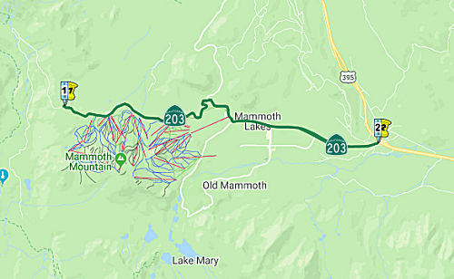 From the Mono county line near Minaret Summit to Route 395.
  Post 1964 Signage History
▸As defined in 1963, this route ran from "Mammoth Lakes to Route 395."
▸In 1967, Chapter 1323 extended the route from the Mono County Line
to Mammoth Lakes: "the Mono county line near Minaret Summit Mammoth
Lakes to Route 395."
▸In 2023, SB 606, Chapter 619, 10/8/2023, authorized relinquishment within the Town of Mammoth Lakes by adding subsection (b)
Between US 395 and Mammoth Lakes, an "Old State Highway" parallels Route 203, taking a much more winding course along Mammoth Creek and running through Mammoth Creek Park. It reconnects with Route 203 at Sawmill Road, just west of the current interchange with the US 395 expressway. (This road is named "Old State Highway" in Compass's map and in Mapquest, but is named "Mammoth Creek Road" in MSN's mapping service.)
Note that the road actually does not end at Minaret Summit. Starting at US 395, the road is open all year round to the town of Mammoth Lakes at about 7,800 feet and to Mammoth Mountain Ski Area Main Lodge and Mammoth Mountain Inn at about 8,950 elevation. In the winter, the road is not plowed past that point. It opens to the public around mid June depending on the snow. It continues up to Minaret Summit, and then it goes down into The San Joaquin River Middle Fork valley (although past Minaret Summit, the road is not longer part of the state highway system, although it may be maintained by the park service). While in the valley there is a turn off for Devil’s Postpile. This turn off goes right to the river. During most of the summer there is a shuttle bus from Mammoth Mountain Inn to the San Joaquin River Middle Fork valley, Devil’s Postpile, and the 2 stables in the valley. From about 7:00 am to 7:00 pm most car traffic is not allowed and you have to take the shuttle bus. There is not enough parking in the valley. The road from the Inn to the summit is great. From the summit the road goes diagonally down a slope. This part of the road is narrow and sometimes downhill vehicles have to back up hill to allow uphill vehicles to pass. Usually if the vehicles are not too wide and drivers plan ahead only slowing down is needed. When the road gets to the valley it makes almost a complete U turn. It then goes down the valley a few miles. This part of the road is again wide enough for 2 way traffic. There are multiple bus stops in the valley. More information is available at www.nps.com for Devil’s Postpile. Fishing and camping are also possible in the valley. The John Muir Trail and Pacific Crest Trail are also down there.
There was once a proposal to extend Route 203/LRN 112 across the Sierras.
At the time, in the throes of the Cold War and on the heels of World War
II, where Eisenhower saw how the German war machine benefitted from the
autobahns, the nation’s defense was one of the principal reasons
forwarded for building the road. As Madera County Supervisor Carl W.
McCollister said: “The road was necessary to give people in the San
Joaquin Valley their rightful highway outlet to the east should coastal
cities become targets of nuclear attack.” Ultimately, however,
opponents of the road argued that the road was impractical and made zero
business sense. Genny Smith, ringleader, organizer, activist, scribe who
fought the road over nearly three decades, commented, “it was
businessmen like Bob [Schotz] who made the difference. This road was a
business proposition from the get-go and a poor one at that. He and his
colleagues knew it and were willing to stand up and say so.” It was
finally stopped during the Reagan Administration (as in, when he was
Governor).
(Source: The Sheet, 8/2/2014, via AARoads)
 Pre 1964 Signage History
This was LRN 112, defined in 1933. It was not signed before 1964.
 Status
In June 2016, the CTC authorized relinquishment of right of way in the Town of Mammoth Lakes along Route 203 between Mountain Boulevard and Minaret Road, consisting of a frontage road. The Town, by relinquishment agreement dated May 13, 2016, agreed to waive the 90-day notice requirement and accept title upon relinquishment by the State.
Route 203 (North Main Street) Sidewalk and Safety Project (~ MNO 5.09 to MNO R4.782)
In January 2021, the Town of Mammoth Lakes put out a
bid for The Route 203 (North Main Street) Sidewalk and Safety Project. The
environmental portion requires a review of the project area, CEQA/NEPA
documentation, and filing of a determination. The engineering design
portion of the project consists of Plans, Technical Specifications and
Estimates (PS&E) for a sidewalk along the north side of Main Street
from Minaret Road to Mountain Boulevard. The sidewalk requires the removal
of two existing retaining walls, the construction of new retaining walls
within the Town right-of-way, and maintaining a four foot shoulder for
bicycle travel. The sidewalk will be designed to manage stormwater and
comply with the ADA. The project will include a transit shelter and
informational signage for pedestrians and vehicular access. The majority
of the construction area is within the Caltrans right-of-way, requiring
construction to follow the conditions set by the Town of Mammoth Lakes and
Caltrans Encroachment Permit. The engineering design portion of the
project consists of Plans, Technical Specifications and Estimates
(PS&E) for a sidewalk along the west side of Minaret Road from Main
Street to the 8050 driveway. The path will be a combination of sidewalk
and a multi-use path, requiring the partial removal of an existing
retaining wall and the design of a small retaining wall adjacent to the
path to preserve the integrity of the Mammoth Fireside building
foundations. The sidewalk/path design will manage stormwater, comply with
the ADA, and identify necessary wayfinding signage. The majority of
construction will occur within the acquired right-of-way and may be
subject to right-of-way conditions limiting construction activities as
well as the conditions set by the Caltrans Encroachment Permit. Therefore,
the design may require special conditions for construction and require
staged construction activities.
(Source: Cached Bid Information)
In June 2021, the CTC approved amending the STIP to use
the funding available through the 2021 Mid-Cycle STIP and share
distribution of the federal Coronavirus Response and Relief Supplemental
Appropriations Act of 2021 funds (COVID Relief Funds) to add a new project
to the STIP: Main Street (Route 203) Multi-Use Path (PPNO 2683); program
$250K to the PS&E phase in FY 2021-22.
(Source: June 2021 CTC Agenda, Agenda Item
2.1a.(19))
 Scenic Route
[SHC 263.1] Entire route.
 Interregional Route
[SHC 164.19] Entire route.
 Other WWW Links
 Statistics
Overall statistics for Route 203:
 Pre-1964 Legislative Route
In 1935, Chapter 429 added the route “...from [LRN 26] near Oasis N-ly to Avenue 66 via Pierce Street.” with no number. In 1937, Chapter 841 deleted the 1935 definition and recreated it as LRN 203, with the same definition. This definition then remained unchanged until the 1963 renumbering.
This route ran from US 99 (present-day Route 86) near Oasis northerly to Avenue 66 via Pierce Street. This is part of present-day Route 195.
© 1996-2020 Daniel P. Faigin.
Maintained by: Daniel P. Faigin
<webmaster@cahighways.org>.
 Route 202
 Route 204