
 California Highways:
Click here for a key to the symbols used. An explanation of acronyms may be found at the bottom of the page.
 Routing
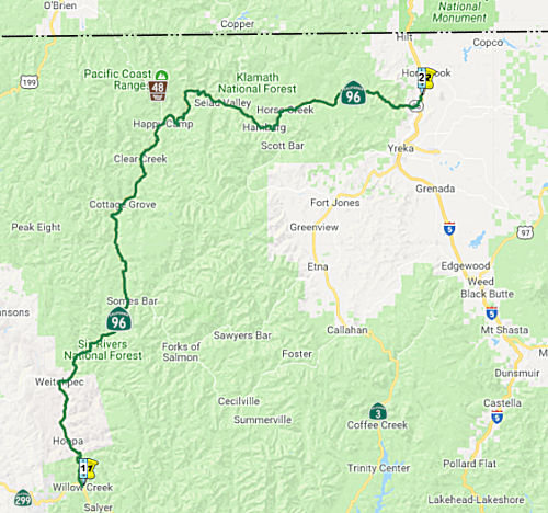 From Route 299 near Willow Creek via the vicinity of Weitchpec to Route 5 near the
confluence of the Shasta and Klamath Rivers.
From Route 299 near Willow Creek via the vicinity of Weitchpec to Route 5 near the
confluence of the Shasta and Klamath Rivers.
 Post 1964 Signage History
In 1963, this routing was defined as "Route 299 near Willow Creek to Route 5 near Klamath River Bridge via the vicinity of Weitchpec."
In 1965, Chapter 1401 changed the terminus to "Route 5 near the north city limit of Yreka via the vicinity of Weitchpec."
In 1968, Chapter 282 changed the terminus again, this time to "Route 5 via the vicinity of Weitchpec near the confluence of the Shasta and Klamath Rivers."
In 1984, Chapter 409 corrected the wording to "Route 299 near Willow Creek via the vicinity of Weitchpec to Route 5 near the confluence of the Shasta and Klamath Rivers."
 Pre 1964 Signage History
The original route of signed Route 96 was added to the state highway
system in 1919 as LRN 46, running along the route from Jct. US 101 at
Klamath to the Klamath River Bridge (Jct. US 99) near Yreka, via Klamath
River. It appears as a projected route by the early 1920 and was under
construction from 1922 to 1924. LRN 46 is shown as a functional highway
from LRN 3/US 99 west to Weitchpec on the 1930 Division of Highways
Map. LRN 46 northwest to LRN 1/US 101 is shown to be a planned
highway along the Klamath River. Bald Hills Road is shown as a
functional connecting local road from LRN 46 in Weitchpec west to LRN 1/US 101.
(Source for some material: Gribblenation Blog: Paper Highways; modern California State Route 169 the unfinished California State Route 96)
The 1934 signage of routes indicated that Route 96 would be signed and aligned over the unfinished LRN 46 from US 101 near Klamath east to US 99 near Yreka via the Klamath River (hence the name; Klamath River Highway). A 1935 State Highway Map still shows the LRN 46 routing as Route 96, with the routing to Willow Creek as Route 96T. In terms of present-day routing, the portion from US 101 at Klamath to Weitchpec is present Route 169, and from Weitchpec to US 99 (I-5) 9 mi N of Yreka is present-day Route 96.
The 1935 Map shows Route 96T, which by 1938 was Route 96, realigned off
of LRN 46 south of Weitchpec to a new routing using LRN 84 to US 299 at
Willow Creek. LRN 84 was added to the State Highway System during
1933. Tom Fearer surmised on the Gribblenation Blog that it was
likely Route 96 was realigned via easier grades of LRN 84, as it followed
the Trinity River to US 299. The planned route of LRN 46 west of
Weitchpec followed a far more flood prone Klamath River to US 101.
(Source for some material: Gribblenation Blog: Paper Highways; modern California State Route 169 the unfinished California State Route 96)
In 1950, the last two covered bridges (Clear Creek and Dillon Creek) on
the State Highway System, which were located on Route 96, were
removed. The Clear Creek and Dillon Creek Covered Bridges were
constructed during 1921-1922 by the United States Bureau of Public Roads
when the Klamath River Highway was in a primitive state of repair.
The Clear Creek Covered Bridge is noted to have been built with an
eleven-foot-wide road deck whereas the Dillon Creek Covered Bridge had a
fifteen-foot nine-inch-wide road deck.
(Source: Gribblenation Blog (Tom Fearer), "The last covered bridges of the California State Highway System (California State Route 96)", February 2023)
The 1968 change added a small portion of LRN 3 (1910) [the portion from Route 263 to I-5] to the route as a result of a transfer from Route 263.
 Status
In June 2015, the CTC approved for future consideration of funding a project in Humboldt County that will realign curves, widen shoulders, replace existing culverts, install rumble strips, construct a retaining wall, install guardrail, and overlay bonded wearing course on Route 96 near the community of Willow Creek (~ HUM 0.014). The project is programmed in the 2014 State Highway Operation and Protection Program. The estimated cost is $6,049,000 for capital and support. Construction is estimated to begin in Fiscal Year 2016-17. The scope, as described for the preferred alternative, is consistent with the project scope programmed by the Commission in the 2014 State Highway Operation and Protection Program.
In February 2019, it was reported that the CTC allocated $171,000 in
right-of-way support costs for bridge projects on Route 96 and US 101 in
Humboldt County. The projects willrevamp three bridges at the following
locations in Humboldt County: The Willow Creek Bridge on Route 96 (HUM
000.24, Bridge 04-0135), the Camp Creek Bridge on Route 96 (HUM R037.25,
Bridge 04-0066) in Orleans, and the G Street Overcrossing along US 101 in
Arcata.
(Source: Lake County Record Bee, 2/6/2019)
In August 2011, the CTC approved $4,725,000 in SHOPP funding for maintenance along Route 96 near Orleans, from Salmon River Bridge (SIS R000.04) to Klamath River Bridge (SIS R015.61) at various locations. This work would rehabilitate six bridges by performing preventive maintenance to provide smoother ride and extend the life of the structures. They also approved $2,160,000 in SHOPP funding to rehabilitate the existing drainage system at 82 locations near Somebar, from Humboldt County line to 1.2 miles east of Scott River Bridge to upgrade drainage system components that have reached the end of their useful lives to reduce maintenance costs and maintenance exposure to traffic.
In December 2021, the CTC approved for future consideration of funding
02-Sis-96, PM 43.5/57.0. Portuguese Creek and Cade Creek Fish Passage
Project. Replace existing culverts with bridges at Cade Creek and
Portuguese Creek on Route 96 in Siskiyou County. (ND) (PPNO 3620) (SHOPP).
This project is located on Route 96 at PM 43.5/43.8, and 57 in Siskiyou
County. The Department proposes to replace existing culverts with new
bridges at Cade Creek and Portuguese Creek, reconstruct approach roadways,
restore stream channels upstream and downstream of the new bridges. The
purpose of the project is to provide structurally sound structures that
meet current highway standards and fish passage criteria as mandated by
State and Federal law. This project is currently programmed in the 2020
SHOPP for a total of $19,739,000, which includes Construction (capital and
support) and Right of Way (support). Construction is estimated to begin in
2023. The scope, as described for the preferred alternative, is consistent
with the project scope as programmed by the Commission in the 2020 SHOPP.
A copy of the ND has been provided to Commission staff. The project
will result in less than significant impacts to the environment.
(Source: December 2021 CTC Agenda, Agenda Item
2.2c.(1))
In August 2016, the CTC approved for future consideration of funding a project on Route 96 (02-Sis-96, PM 52.48, 60.17, 88.26) in Siskiyou County that will replace nonstandard bridge rails on three bridges; at Thompson Creek, Seiad Creek, and Beaver Creek; between Happy Camp and I-5. The project is programmed in the 2014 State Highway Operation and Protection Program. The total programmed amount is $16,350,000 for capital and support. Construction is estimated to begin in Fiscal Year 2017-18. The scope, as described for the preferred alternative, is consistent with the project scope programmed by the Commission in the 2014 State Highway Operation and Protection Program.
The 2022 SHOPP included the following new long lead project:
02-Siskiyou-96 71.2. PPNO 3660; ProjID 0216000125; EA 0H730. Route 96 Near
Hamburg, at Scott River Bridge № 02-0079. Replace existing bridge
deck and widen bridge. Total project cost: $20,623K Begin Con: 6/26/2027.
(Source: “2022 State Highway Operation
And Protection Program, Fiscal Years 2022-23 through 2025-26”,
March 17, 2022)
Klamath River Bridge No. 02-0117 (02-Siskiyou-96 PM 76.8/78.0)
 The following project was included in the final adopted 2018 SHOPP as a "Long Lead Project" in March 2018: PPNO 3629. 02-Siskiyou-96 76.8/78.0. Route 96 Near Horse Creek, at Horse Creek Bridge
No. 02-0117, from 0.4 mile west of Klamath River Bridge to 2.0 miles west
of Kohl Creek. Replace bridge on new alignment to correct scour critical
conditions, improve safety, and reduce operational deficiencies. Note:
Environmental approval requires 36 months due to Section 7 formal
consultation with NOAA. * PA&ED phase(s) is authorized. Begin Con:
4/27/2024. Total Project Cost: $31,333K.
The following project was included in the final adopted 2018 SHOPP as a "Long Lead Project" in March 2018: PPNO 3629. 02-Siskiyou-96 76.8/78.0. Route 96 Near Horse Creek, at Horse Creek Bridge
No. 02-0117, from 0.4 mile west of Klamath River Bridge to 2.0 miles west
of Kohl Creek. Replace bridge on new alignment to correct scour critical
conditions, improve safety, and reduce operational deficiencies. Note:
Environmental approval requires 36 months due to Section 7 formal
consultation with NOAA. * PA&ED phase(s) is authorized. Begin Con:
4/27/2024. Total Project Cost: $31,333K.
The 2020 SHOPP, approved in May 2020, included the
following Bridge Preservation item of interest (carried over from the 2018
SHOPP): 02-Siskiyou-96 PM 76.8/78.0 PPNO 3629 Proj ID 0216000040 EA 1H360.
Route 96 near Horse Creek, at Horse Creek Bridge No. 02-0117, from 0.4
mile west of Klamath River Bridge to 2.0 miles west of Kohl Creek. Replace
bridge on new alignment to correct scour critical conditions, improve
safety, and reduce operational deficiencies. Programmed in FY23-24, with
construction scheduled to start at the end of April 2024. Total project
cost is $43,873K, with $33,293K being capital (const and right of way) and
$10,580K being support (engineering, environmental, etc.).
(Source: 2020 Approved SHOPP a/o May 2020)
In December 2021, it was reported that the Horse Creek
Bridge Replacement Project will replace the Klamath River Bridge on Route 96 in Siskiyou County near Horse Creek. Construction is currently planned
to begin in the spring of 2024, with tree cutting in the fall of 2023.
Originally constructed in 1953, the existing bridge is planned for
replacement due to scour around the piers. The new bridge will be 545 feet
long, 44 feet wide, and constructed on a new highway alignment in the
area. The purpose of the project is to provide safe, sustainable, and
traversable structure to the public, reduce operational deficiencies,
improve worker safety, and decrease maintenance and repair costs. The $44
million project will be funded in part by Senate Bill (SB) 1.
(Source: District 2 on FB, 12/21/2021)
In March 2022, the CTC approved for future
consideration of funding 02-Sis-96, PM 76.8/78.0 PPNO 02-3629, Horse
Creek Bridge Replacement Project. Replace the Klamath River Bridge
on Route 96 near Horse Creek in Siskiyou County. The project is located on
Route 96 from PM 76.8 to 78.0, in Siskiyou County. The proposed
project would replace the Klamath River Bridge near Horse Creek with a
three-span bridge with two 12-foot lanes with 8-foot shoulders. This
project is currently programmed in the 2020 SHOPP for a total of
$41,233,000, which includes Plans, Specifications and Estimate, Right of
Way (capital and support), and Construction (capital and support).
Construction is estimated to begin in 2023-24. The scope, as described for
the preferred alternative, is consistent with the project scope as
programmed by the Commission in the 2020 SHOPP.
(Source: March 2022 CTC Agenda, Agenda Item
2.2c.(1))
Also in March 2022, the CTC approved the following
SHOPP SB1 pre-construction phase allocation: 02-Sis-96 76.8/78.0. PPNO
02-3629; ProjID 0216000040; EA 1H360. Route 96 Near Horse Creek, at Horse
Creek Bridge № 02-0117, from 0.4 mile west of Klamath River Bridge
to 2.0 miles west of Kohl Creek. Replace bridge on new alignment to
correct scour critical conditions, improve safety, and reduce operational
deficiencies. (Concurrent consideration of funding under Resolution
E-22-13; March 2022.) Allocation: PS&E $2,810,000; R/W Sup $830,000.
(Source: March 2022 CTC Agenda, Agenda Item
2.5b.(2b) #4)
In December 2023, the CTC approved the following
amendment to a project in the 2022 SHOPP: (1d) #8. 02-Sis-96 76.8/78.0
PPNO 02-3629; ProjID 0216000040; EA 1H360. Route 96 Near Horse Creek, at Horse
Creek Klamath River Bridge № 02-0117, from 0.4
mile west of Klamath River Bridge to 2.0 miles west of Kohl Creek. Replace
bridge on new alignment to correct scour critical conditions, improve
safety, and reduce operational deficiencies. Concurrent CONST and CON ENG
allocation under Resolution FP-23-48; December 2023. Note: Split plant
establishment and monitoring work into project EA 1H361/PPNO 02-3905 from
parent project EA 1H360/PPNO 02-3629. Correct the error in bridge name.
Allocation Changes ($ × $1000):Con Sup $4,300 $4,100;
Const Cap $32,300 $32,160; Total $43,873
$43,533.
(Source: December 2023 CTC Agenda, Agenda Item 2.1a.(1d) #8)
In December 2023, the CTC approved the following SHOPP
construction-phase allocation: $39,390,000. 02-Sis-96 76.8/78.0.
PPNO 02-3629; ProjID 0216000040; EA 1H360. Route 96 Near Horse Creek, at
Klamath River Bridge № 02-0117, from 0.4 mile west of Klamath River
Bridge to 2.0 miles west of Kohl Creek. Outcome/Output: Replace bridge on
new alignment to correct scour critical conditions, improve safety, and
reduce operational deficiencies. CEQA - MND, 01/10/2022; Re-validation
10/12/2023. NEPA - CE, 01/11/2022; Re-validation 10/12/2023. Future
consideration of funding approved under Resolution E-22-13; March 2022. As
part of this allocation request, the Department is requesting to extend
the completion of CON ENG an additional 11 months beyond the 36
month deadline. Concurrent Amendment under SHOPP Amendment 22H-014;
December 2023. Programmed (Allocated): CON ENG $4,100,000
($4,100,000); CONST $32,160,000 ($35,290,000).
(Source: December 2023 CTC Agenda, Agenda Item 2.5b.(1) #3)
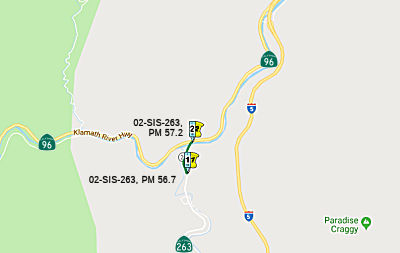
Klamath River Bridge (02-SIS-96, PM 103.00/103.6, 02-SIS-263, PM 56.7/57.2)
 In July 2016, it was reported that a historic but deteriorating 85 year old bridge crossing the
Klamath River on Route 263 is proposed for demolition and replacement in
the near future, according to Caltrans documents. A Caltrans historic
bridge survey determined that the Klamath River Bridge meets criteria to
be listed in the National Register of Historic Places. As such, Caltrans
must do some form of mitigation, but it could be as little as an
informational plaque. The northernmost of a set of five bridges built in
the 1930s on former US 99 through the Shasta River canyon, this piece of
road was at that time “the most thickly bridged section” of
any state highway in California. An alternate plan to blast tunnels
through the rock formations was rejected. The bridge has an unusual 600
foot radius curve built into it, negating what would be sharp right angle
turns on the north side. It is of “T-beam” construction, a
less common variety of girder design associated with the 1930s. The
original “window railings” were replaced with solid barriers
in the late 1970s. The new bridge’s design and exact location is yet
to be revealed but its construction is set to take out an old residence on
the north bank of the river, the former Kamp Klamath (later called
Richie’s Store and Gas Station) that served early day motorists.
In July 2016, it was reported that a historic but deteriorating 85 year old bridge crossing the
Klamath River on Route 263 is proposed for demolition and replacement in
the near future, according to Caltrans documents. A Caltrans historic
bridge survey determined that the Klamath River Bridge meets criteria to
be listed in the National Register of Historic Places. As such, Caltrans
must do some form of mitigation, but it could be as little as an
informational plaque. The northernmost of a set of five bridges built in
the 1930s on former US 99 through the Shasta River canyon, this piece of
road was at that time “the most thickly bridged section” of
any state highway in California. An alternate plan to blast tunnels
through the rock formations was rejected. The bridge has an unusual 600
foot radius curve built into it, negating what would be sharp right angle
turns on the north side. It is of “T-beam” construction, a
less common variety of girder design associated with the 1930s. The
original “window railings” were replaced with solid barriers
in the late 1970s. The new bridge’s design and exact location is yet
to be revealed but its construction is set to take out an old residence on
the north bank of the river, the former Kamp Klamath (later called
Richie’s Store and Gas Station) that served early day motorists.
(Source: Siskiyou Daily News, 7/15/2016)
In January 2017, the CTC approved for future consideration of funding a project in Siskiyou County that will replace the Klamath River Bridge on Route 263 near the city of Yreka (near the intersection of Route 96, making the scope 02-SIS-96, PM 103.00/103.6, 02-SIS-263, PM 56.7/57.2). The project is programmed in the 2016 State Highway Operation and Protection Program. The total programmed amount is $22,940,000 for capital and support. Construction is estimated to begin in Fiscal Year 2018-19. The scope, as described for the preferred alternative, is consistent with the project scope programmed by the Commission in the 2016 State Highway Operation and Protection Program.
In August 2018, it was reported that the CTC approved
$18.6 million for a project that will replace the Klamath River Bridge on
Route 263 from north of the Shasta River Bridge to Route 96 near the city
of Yreka, and Route 96 east of State Route 263 in Siskiyou County.
(Source: Action News Now, 8/20/2018)
In December 2018, the CTC approved the California Department of Transportation’s (Department) request for an additional $4,600,000 for the State Highway Operation Protection Program (SHOPP) Bridge Replacement project (PPNO 3424) on Route 263 and Route 96 in Siskiyou County, to award the construction contract. This is an increase of 30% over the construction capital amount. This project is located at the intersection of Route 263 and Route 96 near the city of Yreka, in Siskiyou County. The project will replace the existing Klamath River Bridge, which is over 85 years old and has deteriorated extensively. The new bridge will be wider than the existing bridge to accommodate wider shoulders to meet current standards. The contract award status is pending approval of this request for supplemental funds. Construction would begin in Spring of 2019, would take 350 working days, and be completed in November 2021.
The Engineer's Estimate (EE) for this project was
updated in May 2018 which included consideration of the project’s
remote location. In addition, the Department requested an increase to the
original programmed amount, to account for both the higher bidding
environment and higher construction costs throughout the region. The
Department discussed the bid results and compared bid prices with the
contractors, including those who opted out of the bidding process.
Although 15 contractors, sub-contractors and material suppliers obtained
contract plans for the project, only two contractors submitted bids for
this project. The contractors stated that this project includes many
difficult, specialty contract items which only a few contractors can
perform. Some of the difficult items on this contract include constructing
the bridge foundation in a rocky, river environment and support falsework
for an arch structure over a flowing river. The difficulty to construct
this bridge, the bridge’s remote location and environmental
constraints due to the proximity of the Klamath River, present added
challenges and higher risks to the contractor. All these challenges and
risks resulted in a limited number of bidders and higher contract bids.
The EE was developed appropriate for the project including the challenging
location of the existing bridge. However, the EE was still undervalued as
the current trends were beyond expectations. While there are only two
bidders on the project, the existing bridge is in an extensively
deteriorated condition, and urgently needs to be replaced to ensure the
safety of the traveling public. The Department has reviewed the bid
results for possible mathematical or material unbalancing in accordance
with 23CFR 635.102, and 23CFR 635.114. The bids appear to be
mathematically balanced and there is no evidence of material unbalancing
of the low bid.
(Source: December 2018 CTC Minutes, Agenda Item 2.5e.(4))
In April 2021, it was reported that Route 263 has been
rerouted onto the new new Klamath River Bridge, north of Yreka. There will
be intermittent traffic control and closures on both Route 263 and Route 96 throughout summer 2021 as work continues on the project. The old
Klamath River Bridge is anticipated to be removed starting in June of 2021
and continue through July of 2021. The project is anticipated to be
completed by the end of October 2021.
(Source: Caltrans District 2 FB Post, 4/28/2021)
In August 2021, the CTC approved a request for an
additional $500,000 in Construction Support for the SHOPP Bridge
Replacement project on Route 263 in Siskiyou County, to complete the
construction contract. The project (PPNO 02-3424; ProjID 0200000586; EA
2E480) is located on Route 96 and Route 263 near the city of Yreka in
Siskiyou County (02-Sis-263 56.8/57.2, 02-Sis-263 56.8/57.194, 02-Sis-096
103.1/103.6). The project will replace a bridge 8 miles north of Yreka,
from 0.3 mile north of Shasta River Bridge to Route 96, also on Route 96,
from 0.5 mile west to 0.2 mile east of Route 263. The project’s
construction support was programmed for $3,100,000 in the SHOPP for
delivery in 2021-22 and was allocated by the Commission in August 2018 for
$3,100,000; G-12 funds in the amount of $510,000 was approved in March
2021. The project was awarded in December 2018 with construction
beginning in February 2019. The project is expected to be completed
in November 2021. The remaining budget is $137,000 and is insufficient to
complete construction. The project is currently 85 percent complete. The
project experienced various obstacles during construction that resulted in
an increase to the construction support cost. At the start of
construction, differing site conditions were discovered; as there was a
discrepancy between the Digital Terrain Model (DTM) and field conditions
on site. The DTM did not penetrate the vegetation well enough to capture
the ground elevation. The inaccurate survey file created rework for the
Surveys and Design team, and triggered a change order work for a cofferdam
around the thrust block and additional environmental coordination with
California Fish and Wildlife, National Marine Fisheries Service and
Regional Water Board. The cofferdam was not anticipated for this
project as the thrust block was originally anticipated to be outside of
the waterway. Adding to construction support cost, the contractor’s
drilling equipment continuously broke down and delayed the drilling
schedule approximately 7 months. Given the remote location of the project,
and uncertainty of whether the equipment would be fixed timely, inspectors
would remain onsite. To address the delays, the contractor worked
overtime and added extra shifts, which required additional inspection
hours from the construction support crew. When the contractor commenced
removing the falsework, the first column moved out of alignment. After a
design review, it was decided that the contractor must rebuild the column.
While reconstruction is the responsibility of the contractor, additional
Department staff resources were required to analyze the column, inspect
the work, and provide additional survey verification of the falsework and
column forms. The COVID-19 pandemic has also impacted the resource use of
the survey crew. Crews typically stay overnight in Yreka to maximize the
time on the jobsite; however, lodging was unavailable which required the
crew to return to Redding each day which is two hours away. The additional
travel time extended the number of days the crew were needed on site,
compounding the overall time spent on the project. These supplemental
funds will be utilized to address the additional construction support
costs needed as well as the 5-year mitigation plan.
(Source: August 2021 CTC Agenda, Agenda Item
2.5e.(6))
In November 2021, it was reported that the new $18
million Klamath River Bridge, a 300-ft. long, one lane in each direction,
arch structure located north of Yreka, Calif., constructed by Golden State
Bridge Inc. for the California Department of Transportation (Caltrans),
was fully delivered on Oct. 1, 2021. The complex project dealt with many
environmental hurdles, which required a unique falsework system envisioned
and implemented by Golden State's Project Manager Paul Lukaszewicz,
Superintendent Jim Banbury and Project Engineer Evan Huber to meet all
concerns of the permitting agencies with no temporary structures in the
flowing water. An engineered bridge removal plan also was required to
dismantle the old structure and prevent debris from falling into the
river. The work took place near the city of Yreka, a Caltrans District 2
initiative, that also widened existing roads for today's standards. The
bridge is located at the junction of Route 96 and Route 263. Crews
completed the new structure in 2020 and in 2021 realigned the highway to
tie it in to the new bridge and removed the old structure. Challenges
included extremely difficult pile installation due to high water table,
loose overburden consisting of sand couples and boulders with 30 KSI
bedrock below. There was an existing utility that interfered with the pile
driving — a 60 KV electrical line that had to be relocated. The CIDH
pile installation was extremely difficult as there were loose soils over
the very hard rock, consisting of sand, gravel and big boulders. Beyond
that, the bedrock was 30,000 PSI in water — it was the worst
combination of everything for pile installations. The new bridge is west
of the old one and its location improved turning radiuses and sight
distances and lowered the existing grade considerably.
(Source: Construction Equipment Guide, 11/3/2021)
 Naming
 Between Yreka California, and O'Brien Oregon, Route 96,
together with US Forest Route 48N01, is designated as "State of Jefferson National Scenic Byway". The Route 96 portion is
from Route 263 [263 SIS 49.086 to 263 SIS 57.088] to Happy Camp (~ SIS
88.239 to SIS 103.388).This is in recognition of the once proposed State
of Jefferson. Jefferson was proposed to be located in the mountain border
region of what is more commonly known as Northern California and Southern
Oregon. The State of Jefferson secession movement of 1941 was begun
primarily to draw attention to the need of good roads into the back
country to access vital mineral and timber resources for defense related
purposes before the United States was drawn into WWII. For information on
the State of Jefferson, see http://www.stateofjefferson.com/. This appears to have been named at the national level.
Between Yreka California, and O'Brien Oregon, Route 96,
together with US Forest Route 48N01, is designated as "State of Jefferson National Scenic Byway". The Route 96 portion is
from Route 263 [263 SIS 49.086 to 263 SIS 57.088] to Happy Camp (~ SIS
88.239 to SIS 103.388).This is in recognition of the once proposed State
of Jefferson. Jefferson was proposed to be located in the mountain border
region of what is more commonly known as Northern California and Southern
Oregon. The State of Jefferson secession movement of 1941 was begun
primarily to draw attention to the need of good roads into the back
country to access vital mineral and timber resources for defense related
purposes before the United States was drawn into WWII. For information on
the State of Jefferson, see http://www.stateofjefferson.com/. This appears to have been named at the national level.
(Image source: Living Gold Press, North State Public Radio, Wikipedia)
 Named Structures
Bridge 04-0240 (nee 04-0402?) (HUM R039.48), at Pearch Creek in Humboldt county, is named the "Henry Edgar Beck Jr. Memorial Bridge". Henry Edgar Beck, Jr. worked as a highway maintenance equipment operator and acting foreman for the State Division of Highways from 1926 to his retirement in 1965. It was built in 1974, and was named by Senate Concurrent Resolution 71 in 1977.
Bridge 02-0177 (SIS R000.04) over the Salmon River (Somes Bar) in Siskiyou county is named the "Carl Langford Memorial Bridge". It was built in 1974, and was named by Senate Concurrent Resolution 143 in 1974. Carl Langford was the owner of the Somes Bar Store and served as the local Postmaster from 1926 until his death in 1949.
Bridge 02-0156 (SIS R005.08), at the Klamath River in Siskiyou county, is named the "Lyle H. Davis Memorial Bridge". It was built in 1970, and named by Senate Concurrent Resolution 127 in 1974. Lyle Davis died March 13, 1974, operating heavy equipment while pioneering a new road for Route 96 near Windy Point between Orleans and Somes Bar.
 Scenic Route
[SHC 263.1] Entire route.
According to Dan Kilmer, "Route 96 is very well maintained between I-5 and Happy Camp, CA. (a distance of approximately 63 miles) and is becoming more and more popular with motorcyclists due to the beautiful scenery and very comfortable riding conditions (due to smooth road surfaces). In fact, Happy Camp last year hosted a second annual motorcycle ralley that is fast becoming popular. There is also a not so well maintained road over the Siskiyou Mountains from Happy Camp north to O'Brien or Cave Junction, Oregon and Route 199 that is also very scenic, although it is slow due to lots of tight turns and, in some areas, poor road surfaces."
 Other WWW Links
 Statistics
Overall statistics for Route 96:
 Pre-1964 Legislative Route
LRN 96 was defined in 1933 as the route from "[LRN 23] near Bridgeport to the Nevada line via Walker River." This definition was codified as LRN 96 in 1935, and remained unchanged until the 1963 renumbering. This was unsigned before 1964, and is present-day Route 182.
© 1996-2020 Daniel P. Faigin.
Maintained by: Daniel P. Faigin
<webmaster@cahighways.org>.
 Route 95
 Route 97