
 California Highways:
Click here for a key to the symbols used. An explanation of acronyms may be found at the bottom of the page.
 Routing
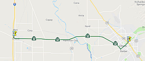 From Route 5 near Orland to Route 99 near Chico.
 Post 1964 Signage History
In 1963, this segment was defined to run from "Route 5 near Orland to Chico". In 1972, Chapter 1216 changed the terminus to "Route 99 near Chico".
 Pre 1964 Signage History
In 1934, Route 32 was signed along the route from Orland at Jct. US 99 to Jct. Route 36 near Deer Creek Meadows, via Chico. It was LRN 47 between US 99W (LRN 7; present-day I-5) and US 99E (LRN 3; present-day Route 99). This portion of LRN 47 was defined in 1919.
 Status
Postmile Note: There is a brief section of L and R postmiles to the W of 6th Street (old US 99W) before GLE 0.0, which is at old 99W (6th Street).
In July 2008, the CTC relinquished right of way in the city of Orland between postmile L0.30 and the westerly right of way of the Southern Pacific Railroad (~ GLE L0.30 to GLE 0.049) consisting of superseded highway right of way, and relocated and reconstructed city streets, sidewalks, and landscape areas.
In February 2022, it was reported that Orland will be receiving funds as
part of Governor Gavin Newsom’s $1.1 billion Clean California
initiative. Specifically, money from Caltrans will help fund the Orland
Interchange Beautification Project (~ 03-Gle-32 0.0) . This $2.7 million
project, which is set to begin construction in July and be completed by
December, will improve and upgrade the I-5 and Route 32 interchange.
Enhancements will include sculpture artwork, slope paving, and the
installation of inert landscape materials.
(Source: Glenn County Transcript, 2/16/2022)
In July 2002, the CTC considered for funding and future adoption a realignment of Route 32 in the City of Orland. This new route adoption runs from 0.06 mi W of Eighth St to Sixth St (~ GLE R0.335 to GLE 0.0).
In March 2013, the CTC relinquished right of way in the city of Orland along Route 32 at 8th Street (~ GLE R0.395), consisting of collateral facilities inadvertently omitted from a previous relinquishment.
Butte - 32 Chico Rehabilitation Project (03-But-32, PM 5.0/10.2)
In January 2022, the CTC approved for future
consideration of funding Butte - 32 Chico Rehabilitation Project:
On Route 32 construct a serviceable facility for the traveling public,
enhance safety features, and expand multi-modal opportunities on Route 32
in Butte County. (PPNO 2115). The Department proposes to replace pavement,
add new striping and retroreflective pavement markers, enhance bike lanes,
rehabilitate the drainage systems currently in poor condition, improve
shoulders, add Americans with Disability Act improvements, repair and
replace existing failed sidewalks, add sidewalks to close gaps in
current sidewalks, and install new intersection lighting at the
intersections of 8th and Flume and 9th and Flume Streets and traffic
signals at 8th and Walnut and 9th and Walnut Streets. This project is
currently programmed in the 2020 State Highway Operation and Protection
Program (SHOPP) for a total of $34,830,000, which includes Construction
(capital and support). Construction is estimated to begin in
2023-24.
(Source: January 2022 CTC Agenda, Agenda Item
2.2c.(1))
Chico Roundabouts (BUT 7.72/7.794)
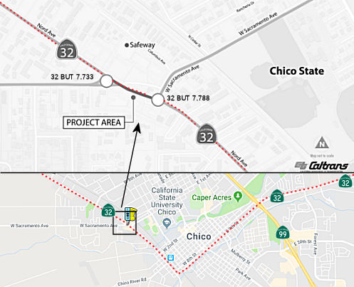 The following project was
included in the final adopted 2018 SHOPP: PPNO 2114. 03-Butte-32 7.6/7.9. On Route 32, In Chico,
from West Sacramento Avenue (East) to West Sacramento Avenue (West).
Construct two roundabouts. Begin Con: 7/30/2020. Total Project Cost:
$6,755K.
The following project was
included in the final adopted 2018 SHOPP: PPNO 2114. 03-Butte-32 7.6/7.9. On Route 32, In Chico,
from West Sacramento Avenue (East) to West Sacramento Avenue (West).
Construct two roundabouts. Begin Con: 7/30/2020. Total Project Cost:
$6,755K.
In August 2018, Caltrans District 3 held a meeting regarding a proposal to construct roundabouts on Route 32 (Nord Avenue) and West Sacramento St. in Chico.
In August 2019, the CTC approved the following project
for future consideration of funding: 03-But-32, PM 7.6/7.9. Route 32 in
Butte County. Construct roadway and intersection improvements on Route 32
in the city of Chico. (PPNO 2114). This project is located on Route 32/Nord Avenue in the city of Chico in Butte County. The project proposes
to construct two roundabouts: Nord Avenue/West Sacramento Avenue (East) to
Nord Avenue/West Sacramento Avenue (West). The proposed project addresses
the need to reduce the high number of accidents and collision severity at
this project location. This project also proposes to improve and update
synchronizing stop light phases, upgrade sidewalks and curb ramps to
comply with current Americans with Disabilities Act standards and update
the Class II Bike lanes and conflict points. The project is currently
programmed in the 2018 State Highway Operation Protection Program (SHOPP)
for an estimated total of $6.8 million which includes Construction
(capital and support) and Right-of-Way (capital and support). Construction
is estimated to begin in 2022. The scope, as described for the preferred
alternative, is consistent with the project scope programmed by the
Commission in the 2018 SHOPP.
(Source: August 2019 CTC Agenda/Minutes, Agenda
Item 2.2c.(1))
In August 2019, the CTC approved the following
allocation: 03-But-32 7.6/7.9. PPNO 2114 Proj ID 0317000084 EA 2H240.
Route 32 In Chico, from West Sacramento Avenue (East) to West Sacramento
Avenue (West). Construct two roundabouts. PS&E $663,000 RW Sup
$756,000.
(Source: August 2019 CTC Agenda, Agenda Item
2.5b.(2a) #6)
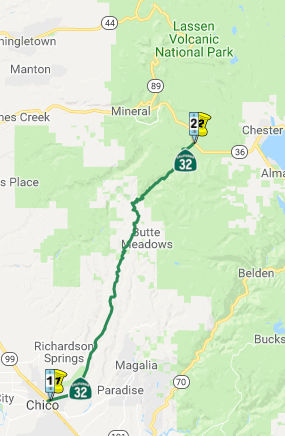 From Route 99 near Chico to Route 36.
Post 1964 Signage HistoryIn 1963, this segment was defined to run from "Route 99 near Chico to Route 36 near Deer Creek Meadows." In 1984, Chapter 409 simplified the definition to "Route 36".
Pre 1964 Signage HistoryIn 1934, Route 32 was signed along the route from Orland at Jct. US 99 to Jct. Route 36 near Deer Creek Meadows, via Chico. Before 1964, this segment of Route 32 was LRN 47 between US 99W (LRN 3) and Route 36 (LRN 29). This portion of LRN 47 was defined in 1933.
In a discussion on AARoads in June 2017, it was noted that there appears to have been a major change in Route 32 from the original highway alignment northeast out of Chico. It would seem that originally Route 32 originally met US 99 East at Park Avenue but used Humboldt Avenue instead of 8th and 9th Street to exit the city. It also seems that Humboldt Avenue is the original alignment directly to the hill climb into the Sierras east of Chico. The original alignment can be seen on the 1935 Butte County Road Map. North to Forest Ranch there doesn't appear to be really any major realigments, whichis interesting considering much of modern Route 32 is 65 MPH, sussing much of the original road grade was used. There appears to be a minor older alignment on Toll Gate Way but really it is too small to pick up on any map. Really everything north of Forest Ranch to Route 36/Route 89 appears to be mostly on the original alignment of Route 32.
 In 1957, a tentative freeway route proposal for 21.7 mi
of Route 32 in Butte County between Hog Springs and Lomo. It begins at the
end of the previously adopted freeway from Chico to Hog Springs, and
follows along the existing route to the vicinity of Forest Ranch where it
runs E of the existing road for approx. 1 mi. From this point on to Lomo
it follows along the existing road deviating only enough to eliminate the
many curves in the existing alignment.
In 1957, a tentative freeway route proposal for 21.7 mi
of Route 32 in Butte County between Hog Springs and Lomo. It begins at the
end of the previously adopted freeway from Chico to Hog Springs, and
follows along the existing route to the vicinity of Forest Ranch where it
runs E of the existing road for approx. 1 mi. From this point on to Lomo
it follows along the existing road deviating only enough to eliminate the
many curves in the existing alignment.
(Source: Chico Enterprise Record, 1/2/1957 via Joel Windmiller,
2/23/2023)
StatusEast Chico Widening (BUT 10.3/11.3)
In 2007, the CTC did not recommend using the Corridor Mobility Improvement Account (CMIA) to fund widening from Route 99 to Yosemite Dr. (~ BUT 10.24R to BUT 12.38). However, in May 2011, the CTC approved for future consideration of funding a project that will widen and improve approximately 2.6 miles of Route 32, beginning at Route 99 and extending past Yosemite Drive. The project will widen Route 32 from two to three lanes in each direction from the east side of the Route 99 interchange to just east of Fir Street. The roadway will then be widened from two to four lanes (two in each direction) from east of Fir Street to Yosemite Drive, where the roadway width will transition down from four lanes to the existing two lanes. The project will also modify the ramp terminal intersections and the couplet at the Route 99/Route 32 Interchange. The Route 32 intersections with Forest Avenue, El Monte Avenue and Bruce Road will be widened and the existing signals will be modified. The Route 32 intersections with Fir Street and Yosemite Drive will be widened and new signals will be installed. The project scope also includes open graded asphalt, shoulder, median, guardrail (timber barrier), landscaping, signal and bridge improvements as well as sound barrier installation along select rear yards of residential properties that abut Route 32. The proposed project will relieve traffic congestion, increase capacity, improve signal operations and enhance safety.
In May 2011, the CTC amended the CMIA baseline agreement for the Route 32 Widen Phase 1 project (PPNO 2107) in Butte County to remain within budget. This included revising the project limits from Post Mile 10.1 - 11.1 to Post Mile 10.3 - 11.3 to accommodate scope change. The purpose of this project is to add a lane in each direction on the section of Route 32 from the Route 32/ Route 99 intersection eastward approximately one mile to the Forest Avenue intersection, which will improve safety, relieve congestion and mitigate traffic queues at the Forest Avenue/Route 32 intersection. During the design phase, it was discovered that the limits of the project would need to be shifted to just east of the Forest Avenue intersection, in order to accommodate the roadway transition from four lanes back down to two lanes. Furthermore, it was discovered that the work to build these roadway design tapers for the transition from four to two lanes, impacts the nearby Dead Horse Slough Bridge, which will now need to be widened. The additional scope and costs related to the widening of Dead Horse Slough Bridge were not part of the original baseline agreement. In order to remain within budget, the project was changed to widen the Dead Horse Slough Bridge to accommodate roadway tapers at Forest Avenue, and to eliminate signal, roadway and widening work at the intersection of Route 32 and Route 99 as well as at Fir Street.
In August 2011, the CTC approved an allocation of $3.425 million to a project to widen to four lanes a stretch of Route 32 in east Chico. The city of Chico will be kicking in $3 million to the Route 32 work, which will stretch east from the park and ride lot at Route 99, to just past the Dead Horse Slough bridge east of Forest Avenue. The work will also extend down Forest to Humboldt Road, and will improve northbound left turns from Forest onto Route 32 by adding a second dedicated left turn lane. The work will include widening the Dead Horse Slough bridge to four lanes. The ultimate plan is to widen the highway to four lanes as far east as Yosemite Drive.
In April 2012, the CTC approved revising the project schedule. The Route 32 Widen Phase 1 project originally proposed to widen Route 32 from Route 99 (BUT 10.1) to east of Forest Avenue (BUT 11.1). The project is needed to improve traffic operations on a portion of Route 32 in an urbanized area of Chico feeding Route 99. The completed improvements will mitigate queues of traffic, relieve congestion, increase capacity, and improve safety. The project was programmed at the Commission’s May 2010 meeting to be funded with a combination of Corridor Mobility Improvement Account funding and local funding. A construction allocation was approved by the Commission at its August 2011 meeting; however a contract award has been delayed due to a recent court decision which affected the project funding. Specifically, the recent California Supreme Court decision that eliminated all re-development agencies and related funding impacted the City’s financial plan for the Route 32 Widen Phase 1 project. Additional time to award the contract wass needed for the City to revise its financial plan in which the City will re-allocate City development impact fees and gas tax revenues to the project. Once the revised financial plan has been approved by the City Council, the City Manager will be able to move forward with awarding the contract which was anticipated by June 30, 2012. Closeout is now estimated for May 2014.
In April 2018, it was reported that construction was starting on the
Colby Curves Realignment Project, on Route 32 in Tehama County (TEH 8.6 to
TEH 9.3). The goal of the realignment is to improve drainage and install
new roadway sections.
(Source: District 2 Tweet, 4/2/2018)
 Naming
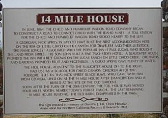 There is an historical plaque in Butte County commemorating the 14 Mile House (~ BUT R21.897). In June 1864, the Chico and Humboldt
Wagon Road Company was incorporated, and John Bidwell and other Chicoans
received the franchise to construct a road to connect the City of Chico
with the Idaho Mines. Nick Spires built accommodations on that road at a
site located on the rim of Little Chico Creek Canyon for travelers and
their livestock. Paul Lucas bought the land from Nick Spires, and Paul
Lucas' son, John Lucas, built a fine two-story hotel. The hotel, a
slaughter house, and a hide house, which later served as a school for
Chico Canyon children, were collectively referred to as 14 Mile House.
Soon after the turn of the 19th century, the toll house that was adjacent
to the road was moved four miles north, nearer to today's Forest Ranch,
and the last remaining 14 Mile House building, the old barn, disappeared
in the 1960's. In 2001, a historical plaque commemorating the 14 Mile
House was authorized in the right-of-way of Route 32 in Butte County at a
site that is located along Route 32, lying approximately 12.7 miles east
of the junction of Route 32 and Route 99, at the site of the 14 Mile
House. Authorized by Senate Concurrent Resolution 59, Chapter 101,
9/4/2001. Additional details on the final erected plaque, which was
installed in 2002, may be found in the Historal Marker Data Base. It was installed at the intersection of Deer Creek Highway (Route 32) and 14 Mile House Drive on Deer Creek
Highway.
There is an historical plaque in Butte County commemorating the 14 Mile House (~ BUT R21.897). In June 1864, the Chico and Humboldt
Wagon Road Company was incorporated, and John Bidwell and other Chicoans
received the franchise to construct a road to connect the City of Chico
with the Idaho Mines. Nick Spires built accommodations on that road at a
site located on the rim of Little Chico Creek Canyon for travelers and
their livestock. Paul Lucas bought the land from Nick Spires, and Paul
Lucas' son, John Lucas, built a fine two-story hotel. The hotel, a
slaughter house, and a hide house, which later served as a school for
Chico Canyon children, were collectively referred to as 14 Mile House.
Soon after the turn of the 19th century, the toll house that was adjacent
to the road was moved four miles north, nearer to today's Forest Ranch,
and the last remaining 14 Mile House building, the old barn, disappeared
in the 1960's. In 2001, a historical plaque commemorating the 14 Mile
House was authorized in the right-of-way of Route 32 in Butte County at a
site that is located along Route 32, lying approximately 12.7 miles east
of the junction of Route 32 and Route 99, at the site of the 14 Mile
House. Authorized by Senate Concurrent Resolution 59, Chapter 101,
9/4/2001. Additional details on the final erected plaque, which was
installed in 2002, may be found in the Historal Marker Data Base. It was installed at the intersection of Deer Creek Highway (Route 32) and 14 Mile House Drive on Deer Creek
Highway.
(Image source: Historical Marker Data Base)
 Freeway
[SHC 253.1] Entire route. Added to the Freeway and Expressway system in 1959.
 Other WWW Links
 Statistics
Overall statistics for Route 32:
 Pre-1964 Legislative Route
The route that would become LRN 32 was originally defined in the 1915 Second Bond Act as "an extension connecting the San Joaquin valley trunk line at a point between the city of Merced in Merced County and the city of Madera in Madera County with the coast trunk line at or near the city of Gilroy in Santa Clara County, through Pacheco Pass, by the most direct and practical route." In 1933, it was extended from "Coast Road near Watsonville to [LRN 2] in Santa Clara Valley via Hecker Pass". Thus, by 1935, it was codified as:
In 1959, Chapter 1062 combined the segments and extended the routing to LRN 249, which was the proposed "Easterly" freeway, Route 65. This made the definition "LRN 56 near Watsonville to LRN 249 near Sharon via Hecker Pass and Pacheco Pass."
This is currently signed as Route 152. As with present-day Route 152, the portion of the routing E of US 99 (LRN 4; present-day Route 99) due E to the Fresno River, where it intersects unconstructed Route 65 (LRN 249) is unconstructed.
© 1996-2020 Daniel P. Faigin.
Maintained by: Daniel P. Faigin
<webmaster@cahighways.org>.
 Route 31
 Route 33