
 California Highways:
Click here for a key to the symbols used. An explanation of acronyms may be found at the bottom of the page.
 Routing
 Post 1964 Signage History
This routing remains as defined in 1963.
Note: Before Route 99 was a freeway what is now Route 233 would have
terminated at Chowchilla Boulevard. Originally Chowchilla Boulevard would
have had a junction with Robertson Boulevard north of the railroad tracks
roughly where the "Chowchilla City Limit" sign is located now.
(Source: Gribblenation Blog (Tom Fearer): "California State Route 233")
A discussion of the Highways to Boulevards program during the March 2022
CTC meeting identified the following segment(s) as potential Highways to
Boulevards conversion projects: Route 233 in the city of Chowchilla.
(Source: March 2022 CTC Agenda, Agenda Item 4.3)
 Pre 1964 Signage History
This was LRN 124, defined in 1933.
 Status
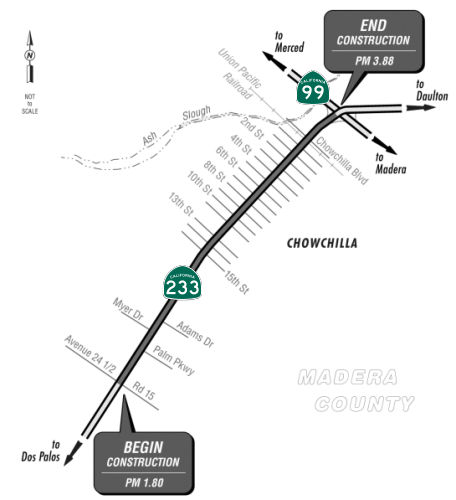
Chowchilla Capital Preventative Maintenance Project (06-Mad-233 1.80/3.88)
 In March 2024, the CTC approved a request for an additional $300,000 (45.5% increase) in
Pre-Construction Support, PA&ED phase, for the following SHOPP
Pavement Preservation project: 06-Mad-233 1.80/3.88. PPNO 06-7095; ProjID
0619000224; EA 0W860. Route 233 In Chowchilla, from Avenue 24½ to
Route 99. Outcome/Output: Rehabilitate pavement and upgrade Transportation
Management System (TMS) elements, roadside signs, and guardrail, and
construct Class 2 bike lanes, Americans with Disabilities Act (ADA)
compliant curb ramps and sidewalks, bulbouts, and flashing beacons as
complete streets and safety elements. Supplemental funds are needed to
complete PA&ED. The project realized cost increases due to the
addition of complete streets and safety elements. The project’s
original scope proposed to rehabilitate the pavement and upgrade
transportation management system elements, roadside signs, and
guardrail. In October 2023, this project was selected to receive
Infrastructure Investment and Jobs Act funding to add complete street and
safety elements. In December 2023, the project was amended to
incorporate complete street and safety elements along Route 233. The
complete street elements consist of adding 2.2 miles of Class II bike
lanes, construct 55 curb ramps/bulbouts, and 1,650 feet of sidewalk.
The safety elements consist of adding and upgrading 2,300 feet of
crosswalks, enhancing the visibility of the 27 crosswalks, and installing
20 flashing beacons. Additional efforts to incorporate the complete
street and safety elements will amount to $300,000. The Department
anticipates requesting allocation for the Plans, Specifications, and
Estimate and Right of Way Support phases in August 2024.
In March 2024, the CTC approved a request for an additional $300,000 (45.5% increase) in
Pre-Construction Support, PA&ED phase, for the following SHOPP
Pavement Preservation project: 06-Mad-233 1.80/3.88. PPNO 06-7095; ProjID
0619000224; EA 0W860. Route 233 In Chowchilla, from Avenue 24½ to
Route 99. Outcome/Output: Rehabilitate pavement and upgrade Transportation
Management System (TMS) elements, roadside signs, and guardrail, and
construct Class 2 bike lanes, Americans with Disabilities Act (ADA)
compliant curb ramps and sidewalks, bulbouts, and flashing beacons as
complete streets and safety elements. Supplemental funds are needed to
complete PA&ED. The project realized cost increases due to the
addition of complete streets and safety elements. The project’s
original scope proposed to rehabilitate the pavement and upgrade
transportation management system elements, roadside signs, and
guardrail. In October 2023, this project was selected to receive
Infrastructure Investment and Jobs Act funding to add complete street and
safety elements. In December 2023, the project was amended to
incorporate complete street and safety elements along Route 233. The
complete street elements consist of adding 2.2 miles of Class II bike
lanes, construct 55 curb ramps/bulbouts, and 1,650 feet of sidewalk.
The safety elements consist of adding and upgrading 2,300 feet of
crosswalks, enhancing the visibility of the 27 crosswalks, and installing
20 flashing beacons. Additional efforts to incorporate the complete
street and safety elements will amount to $300,000. The Department
anticipates requesting allocation for the Plans, Specifications, and
Estimate and Right of Way Support phases in August 2024.
(Source: March 2024 CTC Agenda, Agenda Item 2.5e.(12))
In October 2024, the CTC approved the following changes
to an existing project in the 2024 SHOPP: 06-Mad-233 1.80/3.88. PPNO
06-7095; ProjID 0619000224; EA 0W860. Route 233 In Chowchilla, from Avenue
24 1/2 to Route 99. Rehabilitate pavement and upgrade Transportation
Management System (TMS) elements, roadside signs, and guardrail, and
construct Class 2 bike lanes, Americans with Disabilities Act (ADA)
compliant curb ramps and sidewalks, bulbouts, and flashing beacons as
complete streets and safety elements, and add fiber optic cable.
Concurrent Greater than 20 percent PS&E and R/W Sup allocation under
Resolution FP-24-18; October 2024. Note: Update the Existing Condition
performance table to reflect the latest Automated Pavement Condition
Survey (APCS). Allocation ($ × $1000): PA&ED $660; PS&E $980;
R/W Sup $30; Con Sup $979; R/W Cap $228; Const Cap: $10,575; TOTAL
$13,452.
(Source: October 2024 CTC Agenda, Agenda Item 2.1a.(1d) #7)
In October 2024, the CTC approved for future
consideration of funding 06-Mad-233, PM 1.80/3.88. Chowchilla Capital
Preventative Maintenance Project. Rehabilitate pavement and
upgrade Transportation Management System elements, construct Complete
Streets elements and broadband on Route 233, in Madera County. (ND) (PPNO
7095) (SHOPP). The project is located on Route 233 from PM 1.80 to
PM 3.88, in Madera County. The Department proposes to update existing TMS
elements, modify traffic signals, Rectangular Rapid Flashing Beacon
systems, remove, replace, and modify existing traffic striping and
pavement markers, upgrade existing roadside signs, update guardrails, and
Asphalt Concrete dikes within the project limits, install Class 2 bikeway
access, update curb ramps to current ADA standards, replace ADA curb ramps
with bulb-outs, repair and replace damaged curb, gutter, and sidewalk in
failed areas, add enhanced visibility crosswalks, add sidewalks, add and
upgrade lighting, install bay parking, and add broadband to improve TMS
communication. The project is currently programmed in the 2024 SHOPP. The
total programmed amount which includes Right of Way (Support and Capital),
and Construction (Support and Capital) is $13,452,000. Construction is
estimated to begin in 2026-27. The scope, as described for the preferred
alternative, is consistent with the project scope as programmed by the
Commission in the 2024 SHOPP.
(Source: October 2024 CTC Agenda, Agenda Item 2.2c.(1) #9)
In October 2024, the CTC approved a request for
$3,600,000 (267.3% increase) allocation in Pre-Construction Support,
PS&E phase and $2,660,000 (8,766.7% increase) allocation in Right of
Way (RW) Support phase, for the SHOPP Pavement Preservation project on
Route 233, in Madera County. (PPNO 06-7095; ProjID 0619000224; EA
0W860). 06-Mad-233 1.8/3.88. Allocation (Programmed, if different):
PS&E $3,600,000 ($980,000); RW Sup $2,660,000 ($30,000).In
March 2022, this project was programmed in the SHOPP for $980,000 in
PS&E and $30,000 in RW Support for allocation in Fiscal Year 2023-24.
In December 2023, the project was amended to update the scope by adding
complete streets and safety elements through Infrastructure Investment and
Jobs Act (IIJA) funds. In March 2024, the project was amended again
to update the scope by adding fiber optic cables through IIJA funds.
In June 2024, the project requested an allocation time extension for the
PS&E and RW Support phases. However, the request was deferred to
the August 2024 meeting and approved for four months. In August 2024, the
Department updated the estimate and reflected the need for
$3,600,000 in PS&E (267.3 percent over the programmed amount) and
$2,660,000 in RW Support (8,766.7 percent over the programmed
amount). The project is scheduled to complete the PS&E and RW
Support activities and be Ready to List by March 2026. The PS&E and RW
Support estimates are greater than the current programmed amount due to
the addition of complete streets and safety elements and broadband work.
The scope of this project proposes to rehabilitate the pavement and
upgrade transportation management system elements, roadside signs, and
guardrail along an approximate two-mile segment of SR 233. In
December 2023, during the Project Approval and Environmental Document
phase, an amendment was approved to incorporate complete streets and
safety elements through IIJA funds. The complete streets and safety
elements that will be incorporated into the project consist of
constructing 39 curb ramps, approximately one mile of sidewalk, 17
bulb-outs, and parking cutouts. In addition, the project will
install approximately 1.7 miles of Class II bicycle lanes, 1,260 feet of
enhanced-visibility crosswalks, and 4 flashing beacons. In March
2024, another amendment was approved to incorporate two miles of fiber
optic cables through IIJA funds. The nature of this work is very
detail-oriented and is very time-consuming. This work will also
require a significant amount of coordination with the City and property
owners due to the reduction in lane width and loss of on-street
parking. In addition, the project will require additional traffic
handling. The addition of the complete streets and safety elements
and broadband work will require additional surveys and design efforts.
Initially, right of way efforts were very minimal with no parcels being
impacted. The addition of the complete streets and safety elements
and fiber optic cables has triggered the need for right of way and utility
work. The proposed work will impact 73 parcels. Most of this work
consists of temporary construction easements that are needed to construct
the pedestrian features.
(Source: October 2024 CTC Agenda, Agenda Item 2.5d.(3))
 Other WWW Links
 Statistics
Overall statistics for Route 233:
 Pre-1964 Legislative Route
In 1953, Chapter 1787 defined LRN 233 as: “(a) High Street, Oakland, between [LRN 69] and [LRN 5]; (b) [LRN 227] near the intersection of Park Boulevard, Oakland to [LRN 75] near Lafayette”. Preliminary studies were completed in 1956 covering the location for this future freeway. On December 19, 1956, after various public meetings and a hearing before the Highway Commission, the last gap in the route was adopted and declared a freeway. This future facility will consist of initially four lanes, future six lanes, and starting at the Mountain Boulevard Freeway in Oakland, will traverse Shepherd Canyon and tunnel some 1,400 feet through the Oakland hills. It will span the Redwood Canyon in Contra Costa County and traverse the range of hills easterly thereof entering and crossing the Moraga Valley just north of the present town site. It traverses close to St. Mary's College and terminates at a junction with Route 24 at Pleasant Hill Road. In 1957, Chapter 52 renumbered this definition as LRN 235. It does not appear to have ever been constructed, but corresponds to an unconstructed portion of Route 77.
However, Chapter 1791 also defined LRN 233 as “[LRN 83] near Sierraville to [LRN 21] near Vinto, via Loyalton. Provided, however, that Section 600 of the Streets and Highways Code shall be applicable to the route added to the State Highway System by this section the same as if said route had been added by the Collier-Burns Highway Act of 1947, and the Department of Public Works shall not be required to maintain any portion of said route until the same has been laid out and constructed as a state highway”
In 1955, Chapter 1488 removed the language relating to Section 600.
This was part of Route 49.
© 1996-2024 Daniel P. Faigin.
Maintained by: Daniel P. Faigin
<webmaster@cahighways.org>.
 From Route
  Route 232
 Route 234