
 California Highways:
Click here for a key to the symbols used. An explanation of acronyms may be found at the bottom of the page.
 Routing
 Post 1964 Signage History
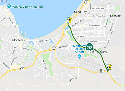
In 1963, this route was defined as “Route 1 near Del Rey Oaks to Route 68 via Canyon del Rey.”
In 1968, Chapter 282 relaxed the definition: “Route 1 near
Del Rey Oaks to Route 68 via Canyon del Rey.”
 Pre 1964 Signage History
This was LRN 169, defined in 1959. It was not signed before 1964; others have noted the first signing may have been in 1969.
 Status
In June 2018, it was reported that studies were started regarding the Canyon Del Rey (Route 218) corridor. According to the page, TAMC is leading the Canyon Del Rey Boulevard (Route 218) Corridor Study in partnership with the cities of Del Rey Oaks, Seaside and Caltrans. The Corridor Study will gather data, conduct a technical traffic forecast analysis, and utilize public input to identify a set of complete streets, stormwater drainage, active transportation, and environmental and wildlife preservation improvements for Canyon Del Rey Blvd from Route 1 to Route 68. Preliminary concepts appear to include converting wye interchanges to roundabouts at Hilby Avenue and Harcourt Avenue, as well as a roundabout at Route 68, and improvements on North Fremont.
 Naming
 The portion of Route 218 from the junction of Route 1 in
the City of Seaside to the junction of Route 68 in the City of Del Rey
Oaks (~ MON 0.0 to MON 1.944) in the County of Monterey (i.e., all of
Route 218) is named the "United States Army Private First Class
Coronado D. Javier Memorial Highway." Named in memory of United
States Army Private First Class Conrado D. Javier, 19 years of age, from
Marina, California, and a Seaside High School graduate, who was killed in
action in Kandahar Province, Afghanistan, on December 19, 2010. Named by
Senate Concurrent Resolution (SCR) 57, Res. Chapter 21, 3/9/2018.
The portion of Route 218 from the junction of Route 1 in
the City of Seaside to the junction of Route 68 in the City of Del Rey
Oaks (~ MON 0.0 to MON 1.944) in the County of Monterey (i.e., all of
Route 218) is named the "United States Army Private First Class
Coronado D. Javier Memorial Highway." Named in memory of United
States Army Private First Class Conrado D. Javier, 19 years of age, from
Marina, California, and a Seaside High School graduate, who was killed in
action in Kandahar Province, Afghanistan, on December 19, 2010. Named by
Senate Concurrent Resolution (SCR) 57, Res. Chapter 21, 3/9/2018.
(Image source: The Californian)
 Other WWW Links
 Statistics
Overall statistics for Route 218:
 Pre-1964 Legislative Route
In 1961, Chapter 1768 defined LRN 218 as “LRN 187 near Yucca Valley to Utah Trail Road in the town of Twentynine Palms.”
This route ran from the Route 62/Route 247 junction near Yucca Valley to Utah Trail Road in the town of Twentynine Palms. This is part of present-day Route 62.
© 1996-2020 Daniel P. Faigin.
Maintained by: Daniel P. Faigin
<webmaster@cahighways.org>.
 From Route
  Route 217
 Route 219