
 California Highways:
Click here for a key to the symbols used. An explanation of acronyms may be found at the bottom of the page.
 Routing
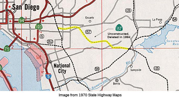 No current routing.
 Post 1964 Signage History
 In 1963, Route 157 was defined as "Route 805 near San Diego and
south of Route 94 to Route 125 near Sweetwater Reservoir.".
In 1972, Chapter 1216 relaxed the routing: "Route 805 near San Diego and
south of Route 94 to Route 125 near Sweetwater Reservoir."
In 1994, the routing (from Route 805 near Ocean View Boulevard near San Diego, through the Paradise Hills to Route 125 near Sweetwater Reservoir) was deleted per AB 3132, Chapter 1220. The route was added to the state highway system in 1959. A routing was adopted in 1962, but it was rescinded locally by SANDAG (San Diego Association of Governments, the regional planning agency) in 1974, and deleted from the state highway system 20 years later. The right-of-way purchased for the eastern portion of the route was sold in the mid-1970s. Together with Route 252 (the Southcrest or El Toyon Freeway) and I-5, the route would have provided direct access from East San Diego County to downtown.
 Pre 1964 Signage History
This was proposed LRN 285, defined in 1959. It was never signed.
Route 157 was not defined as part of the initial state signage of routes in 1934. It is unclear what (if any) route was signed as Route 157 between 1934 and 1964.
 Naming
 Freeway
Originally to have been freeway; later deleted from SHC 253.1.
 Other WWW Links
 Pre-1964 Legislative Route
In 1933, Chapter 767 defined the route from "[LRN 4] near Tunnel Station to [LRN 9] near San Fernando" as a state highway. It was added to the highway code in 1935 as LRN 157 with that routing. This was the route from US 99 (I-5) to Route 118, and was the eventual routing of Route 210 between I-5 and Route 118.
Other WWW Links© 1996-2020 Daniel P. Faigin.
Maintained by: Daniel P. Faigin
<webmaster@cahighways.org>.
 Route 156
 Route 158