
 California Highways:
Click here for a key to the symbols used. An explanation of acronyms may be found at the bottom of the page.
 Routing
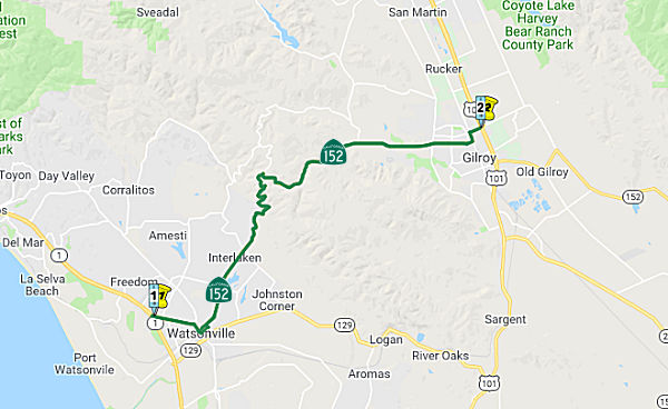 From Route 1 near Watsonville via Hecker Pass to Route 101 in Gilroy.
 Post 1964 Signage History
In 1963, this segment was defined as "(a) Route 1 near Watsonville to Route 101 via Hecker Pass."
In 1990, Chapter 1187 clarified the definition to be: "(a) Route 1 near Watsonville via Hecker Pass to Route 101 in Gilroy."
There were once plans to construct a bypass of Watsonville that would have traversed a path from Freedom to College Lake.
In 2012, Chapter 769 (AB 2679, 9/29/12) authorized relinquishment in Watsonville:
(c) The commission may relinquish to the City of Watsonville the portion of Route 152, beginning at Route 1 and ending at Beverly Drive or some segment thereof, within the city limits of the City of Watsonville, upon terms and conditions the commission finds to be in the best interests of the state.
(d) A relinquishment under this section shall become effective immediately following the county recorder’s recordation of the relinquishment resolution containing the commission’s approval of the terms and conditions of the relinquishment.
(e) On and after the effective date of the relinquishment, both of the following shall occur:
(1) The portion of Route 152 relinquished under this section shall cease to be a state highway.
(2) The portion of Route 152 relinquished under this section shall be ineligible for future adoption under Section 81.
(f) The City of Watsonville shall ensure the continuity of traffic flow on the relinquished portions of Route 152, including, but not limited to, any traffic signal progression.
(g) For those portions of Route 152 that are relinquished, the City of Watsonville shall maintain within its jurisdiction signs directing motorists to the continuation of Route 152.
 Pre 1964 Signage History
This entire route was LRN 32. The original portion of the route, defined in 1915, was between US 101 and Route 99. The portion between Route 1 and US 101 was defined in 1933, and the remainder was defined in 1959. In 1934, Route 152 was signed along the route from Route 1 in Watsonville to Jct. US 99 at Califa via Los Banos.
Westbound Route 152 becomes a one-way roadway on Lake Avenue in
Watsonville from Lincoln Street to Main Street. The original terminus of
Route 152 was at Route 1 at Main Street and it would have been a two-way
road on Lake. Eastbound Route 152 uses Beach Street today from Main Street
to Lincoln Street. Route 1 used to run on Main Street and took a northward
turn on Freedom Boulevard towards Santa Cruz originally.
(Source: Girbblenation Blog (Tom Fearer): "Route 152", 10/4/2017)
 Status
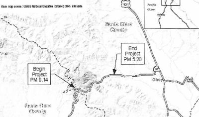 In August 2013, the CTC approved for future consideration
of funding a project that will construct roadway improvements in five
locations on Route 152 near the city of Gilroy (SCL 0.14 to SCL 5.20). The
project is programmed in the 2012 StateHighway Operation and Protection
Program. The total estimated cost is $37,141,000 for capital and support.
Construction is estimated to begin in Fiscal Year 2013-14. The scope, as
described for the preferred alternative, is consistent with the project
scope programmed by the Commission in the 2012 State Highway Operation and
Protection Program.
In August 2013, the CTC approved for future consideration
of funding a project that will construct roadway improvements in five
locations on Route 152 near the city of Gilroy (SCL 0.14 to SCL 5.20). The
project is programmed in the 2012 StateHighway Operation and Protection
Program. The total estimated cost is $37,141,000 for capital and support.
Construction is estimated to begin in Fiscal Year 2013-14. The scope, as
described for the preferred alternative, is consistent with the project
scope programmed by the Commission in the 2012 State Highway Operation and
Protection Program.
In August 2011, the CTC approved $985,000 in SHOPP funding to reestablish highway planting to mitigate the damage done during the bridge replacement construction activity at one location near Gilroy, at Uvas Creek. (152 SCL 006.37).)
In November 2021, it was reported that construction was completed on a
new roundabout on Hecker Pass Highway at Autumn Way (~ SCL 6.904, an
extension of Plum St from Hoey Ranch). Construction began in spring 2021.
A crosswalk was also included in the roundabout, where traffic will slow
down to 30mph. The new traffic pattern is part of the Hecker Pass Specific
Plan, approved in 2005 and last modified in 2015, which provides a
framework for development within 423 acres surrounding Hecker Pass Highway
between Santa Teresa Boulevard and Gilroy Gardens.
(Source: Gilroy Dispatch, 11/22/2021)
 Scenic Route
[SHC 263.7] From Route 1 to the Santa Clara county line at Hecker Pass.
 Naming
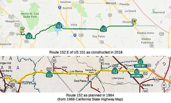 From Route 101 near Gilroy to Route 65 near Sharon via Pacheco Pass.
Post 1964 Signage History▸As defined in 1963, this segment was "(b) Route 101 to Route 65 near Sharon via Pacheco Pass."
▸In 1990, Chapter 1187 clarified the definition to be: "(b) Route 101 near Gilroy to Route 65 near Sharon via Pacheco Pass."
Pre 1964 Signage HistoryThis entire route was LRN 32. The original portion of the route, defined in 1915, was between US 101 and Route 99. The portion between Route 1 and US 101 was defined in 1933, and the remainder was defined in 1959. It was signed as part of the original 1934 signage of state routes.
Gilroy was part of the American El Camino Real that began being
signed as an Auto Trail starting in 1906. In 1913, this became part of the
Pacific Highway. By 1917, CSAA maps were showing early LRN 2/American El
Camino Real/Pacific Highway on Monterey Street in Gilroy, with the western
terminus of LRN 32 (what would become Route 152) entering the city via Old
Gilroy Street. In 1933, LRN 32 was extended west from Gilroy via Hecker
Pass to Watsonville; it was signed as Route 152 in 1934. US 101/Route 152
multiplexed in downtown Gilroy on Monterey Street between Old Gilroy
Street/7th Street to 1st Street by 1935. By 1959, US 101 from Ford Road in
San Jose south through Gilroy was being studied for a potential freeway
upgrade that would tie into the existing four lane expressway segment
south of Gilroy to the San Benito County line, which was completed in
1951. By 1961 a freeway alignment had been adopted, and the freeway
upgrade was completed by 1972. This resulted in US 101 being moved off of
Monterey Street onto the modern freeway bypass. Route 152 was shifted onto
the new freeway between Exit 356/10th Street and Exit 357/Leavesley
Road. Route 152 followed Leavesley Road west to Monterey Street
where it jogged south to reach 1st Street. This was completed by 1975.
(Source: Gribblenation Blog (Tom Fearer), “Former US Route 101 and California State Route 152 in Gilroy”, Feb. 2021)
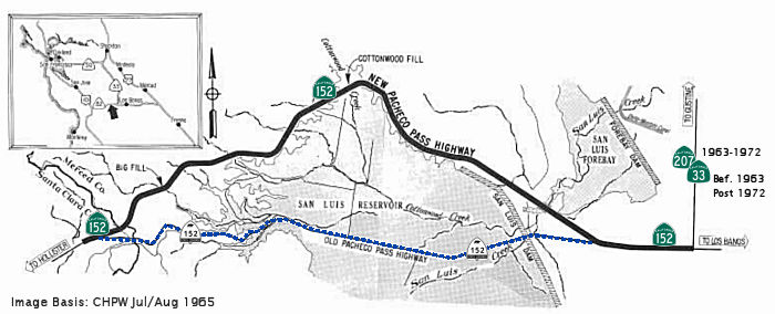 In 1963, there was an extensive relocation of Pacheco
Pass. This was a side effect of the construction of the San Luis Dam, part
of the Central Valley Project. Originally Route 152 took what is now
Dinosaur Point Road from Pacheco Pass through the San Luis Reservoir. The
original routing was replaced in 1966 by the current one in advance of the
San Luis Dam being complete. According to CHPW, the 12 mile section of
Pacheco Pass Highway around the northern portion of the dam opened on
April 29, 1965. The original alignment of Route 152 on occasion
reemerges from the San Luis Reservoir at Dinosaur Point. The incomplete
reservoir can actually be seen on the 1966 California State Highway Map.
The San Luis Reservoir, formed by construction of the new dam, will
provide the only lake of any significant size on the west side of the San
Joaquin Valley. When the reservoir is filled, it will cover more than
13,000 acres and will have a capacity of over 2,000,000 acre-feet of
water. Construction of the new location requireed moving 11,400,000 cubic
yards of earth and rock, paving 12 miles, and constructing two 560' long
bridges... within a 2 year period! In the Salinas Valley, Casa de Fruita
Parkway is the original alignment of Route 152. Within Gilroy, Route 152
continued on 10th to Monterey Road; this was later replaced with a US 101
co-signage.
In 1963, there was an extensive relocation of Pacheco
Pass. This was a side effect of the construction of the San Luis Dam, part
of the Central Valley Project. Originally Route 152 took what is now
Dinosaur Point Road from Pacheco Pass through the San Luis Reservoir. The
original routing was replaced in 1966 by the current one in advance of the
San Luis Dam being complete. According to CHPW, the 12 mile section of
Pacheco Pass Highway around the northern portion of the dam opened on
April 29, 1965. The original alignment of Route 152 on occasion
reemerges from the San Luis Reservoir at Dinosaur Point. The incomplete
reservoir can actually be seen on the 1966 California State Highway Map.
The San Luis Reservoir, formed by construction of the new dam, will
provide the only lake of any significant size on the west side of the San
Joaquin Valley. When the reservoir is filled, it will cover more than
13,000 acres and will have a capacity of over 2,000,000 acre-feet of
water. Construction of the new location requireed moving 11,400,000 cubic
yards of earth and rock, paving 12 miles, and constructing two 560' long
bridges... within a 2 year period! In the Salinas Valley, Casa de Fruita
Parkway is the original alignment of Route 152. Within Gilroy, Route 152
continued on 10th to Monterey Road; this was later replaced with a US 101
co-signage.
(Sources: Gribblenation Blog (Tom Fearer), "Route 152"; CHPW Jul/Aug 1965; Gribblenation Blog (Tom Fearer), "Former California State Route 152 east of Pacheco through the San Luis Reservoir, 11/2023)
Pacheco Pass was a toll road from 1857 to 1878 before it was turned into
a public county route.
(Source: Girbblenation Blog (Tom Fearer): Route 152, 10/4/2017)
 In 1963, the Division of Highways released a map indicating the alternate routes studied for the
Sign Route 152 freeway between LRN 121/Sign Route 33/Jensen Road and the
Madera County line.
In 1963, the Division of Highways released a map indicating the alternate routes studied for the
Sign Route 152 freeway between LRN 121/Sign Route 33/Jensen Road and the
Madera County line.
(Source: Stockton Evening and Sunday Record, 8/30/1963, via Joel
Windmiller, 2/23/2023)
On April 28, 1965, the California Highway Commission passed a resolution
to adopt Route 152 as a freeway route. On January 11, 1966, the
Department and the County of Merced executed a freeway agreement to change
the location of a section of Route 152 in Merced County, between the
Delta-Mendota Canal and 1.1 miles west of the Madera County Line,
identifying it as a freeway. The Route 152 corridor provides three
important transportation services in the State of California: (1) it
serves as a goods movement route connecting the San Joaquin Valley to the
Salinas Valley (Central Coast) and the Southern San Francisco Bay (South
Bay); (2) it provides a commuter route from affordable housing locations
in Merced County to employment locations in Santa Clara and Monterey
Counties; and (3) it provides recreation and tourist access between the
South Bay, Monterey, San Joaquin Valley, and the Sierra Nevada mountains.
Route 152 connects the major north to south corridors of US 101 to I-5 and
Route 99. Route 152 begins at Route 1 in Watsonville and ends at
Route 99 in Madera County, south of Chowchilla. Within District 10,
Route 152 runs through Merced County between Santa Clara County and Madera
County. Route 152 is part of the National Highway System. As a
truck freight route, Route 152 connects three National Truck Network
routes (US 101, I-5, and Route 99). Within District 10, it is
designed to meet the requirements of the Surface Transportation Assistance
Act and is designated a Terminal Access route.
(Source: December 2023 CTC Agenda, Agenda Item 2.3a)
 In December 2023, the CTC approved a notice of intent to rescind the freeway adoption for Route 152
between Santa Fe Grade and Route 59 in Merced County (10-MER-152 PM
23.9/R40.9) and designate Route 152 as a controlled-access highway on its
existing alignment. Route 152 is a divided 4-lane expressway in Merced
County except for the segment within the City of Los Banos, which is a
4-lane conventional highway. Based on traffic forecasts, the
existing facility will still be adequate to accommodate the projected
growth. However, there are unconstructed interchange portions along the
existing alignment. Local agencies with jurisdiction along the
corridor have confirmed there are no longer any local or regional plans to
construct the interchanges and it is appropriate for the Department to
rescind the freeway declaration for the unconstructed portions. Once
the rescission is approved, the Department will dispose of any excess land
previously acquired in the late 1960s for the unconstructed interchange
portions. When this occurs, excess lands will be available to allow for
further community development, promote economic growth, and to relieve the
Department from ongoing maintenance costs of weed abatement, clean-up of
illegal dumping, and other responsibilities. In particular, Merced County
proposed to construct the Westside Transit Operations and Maintenance
Facility, which would be constructed on the west side of Merced County for
the region’s single public transit provider in Merced County, the
Transit Joint Powers Authority for Merced County (TJPA). The intent is to
acquire property along the Route 152 corridor between the City of Los
Banos and the Route 152/Route 33 Wye just north of the City of Dos Palos.
Currently, TJPA has one operations and maintenance facility in Merced that
requires buses that serve the westside of the county to clock unnecessary
hours (and VMT) from the facility to the westside for regular service and
maintenance. A roundtrip from Merced to Los Banos is 76 miles via Route 59
to Route 152 along the entirety of the segment of Route 152 involved in
the proposed rescission. There are also plans to construct the
Pacheco Boulevard (Route 152) Regional Path, a planned multi-use
bicycle/pedestrian path connecting the City of Los Banos and the Merced
College Los Banos campus along the Route 152 corridor. The one-mile path
is planned from Badger Flat Road to the Merced College Los Banos campus to
the west. Under current conditions, students are walking, bicycling, and
skateboarding along Route 152 which is a critical east/west goods movement
corridor and major commute route. The purpose of this project is to
provide students with safe walking and biking access to the Merced College
campus with connectivity to the City of Los Banos’ local bike/ped
network. Currently, no bicycle or pedestrian facilities exit on either the
north or south side of Route 152 from Badger Flat Road and Merced College
Campus Drive. The public notice of the recession was published in January
2024. Written comments on the rescission proposal would be accepted
through March 25, 2024.
In December 2023, the CTC approved a notice of intent to rescind the freeway adoption for Route 152
between Santa Fe Grade and Route 59 in Merced County (10-MER-152 PM
23.9/R40.9) and designate Route 152 as a controlled-access highway on its
existing alignment. Route 152 is a divided 4-lane expressway in Merced
County except for the segment within the City of Los Banos, which is a
4-lane conventional highway. Based on traffic forecasts, the
existing facility will still be adequate to accommodate the projected
growth. However, there are unconstructed interchange portions along the
existing alignment. Local agencies with jurisdiction along the
corridor have confirmed there are no longer any local or regional plans to
construct the interchanges and it is appropriate for the Department to
rescind the freeway declaration for the unconstructed portions. Once
the rescission is approved, the Department will dispose of any excess land
previously acquired in the late 1960s for the unconstructed interchange
portions. When this occurs, excess lands will be available to allow for
further community development, promote economic growth, and to relieve the
Department from ongoing maintenance costs of weed abatement, clean-up of
illegal dumping, and other responsibilities. In particular, Merced County
proposed to construct the Westside Transit Operations and Maintenance
Facility, which would be constructed on the west side of Merced County for
the region’s single public transit provider in Merced County, the
Transit Joint Powers Authority for Merced County (TJPA). The intent is to
acquire property along the Route 152 corridor between the City of Los
Banos and the Route 152/Route 33 Wye just north of the City of Dos Palos.
Currently, TJPA has one operations and maintenance facility in Merced that
requires buses that serve the westside of the county to clock unnecessary
hours (and VMT) from the facility to the westside for regular service and
maintenance. A roundtrip from Merced to Los Banos is 76 miles via Route 59
to Route 152 along the entirety of the segment of Route 152 involved in
the proposed rescission. There are also plans to construct the
Pacheco Boulevard (Route 152) Regional Path, a planned multi-use
bicycle/pedestrian path connecting the City of Los Banos and the Merced
College Los Banos campus along the Route 152 corridor. The one-mile path
is planned from Badger Flat Road to the Merced College Los Banos campus to
the west. Under current conditions, students are walking, bicycling, and
skateboarding along Route 152 which is a critical east/west goods movement
corridor and major commute route. The purpose of this project is to
provide students with safe walking and biking access to the Merced College
campus with connectivity to the City of Los Banos’ local bike/ped
network. Currently, no bicycle or pedestrian facilities exit on either the
north or south side of Route 152 from Badger Flat Road and Merced College
Campus Drive. The public notice of the recession was published in January
2024. Written comments on the rescission proposal would be accepted
through March 25, 2024.
(Source: December 2023 CTC Agenda, Agenda Item 2.3a; Caltrans District 10, Jan 2024)
Status The 2013 Traversable Highways report indicates this is unconstructed from Route 99 to Route 65. No traversable highway. No
recommendation.
The 2013 Traversable Highways report indicates this is unconstructed from Route 99 to Route 65. No traversable highway. No
recommendation.
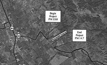 In August 2015, the CTC approved for future consideration
of funding a project in Santa Clara County that will widen the shoulders,
install rumble strips, and improve drainage on portion of Route 152 (SCL
13.8 to SCL 14.7) near the city of Gilroy. The project is programmed in
the 2014 State Highway Operation and Protection Program. The total
estimated cost is $7,717,000 for capital and support. Construction is
estimated to begin in Fiscal Year 2016-17. The scope, as described for the
preferred alternative, is consistent with the project scope programmed by
the Commission in the 2014 State Highway Operation and Protection Program.
In August 2015, the CTC approved for future consideration
of funding a project in Santa Clara County that will widen the shoulders,
install rumble strips, and improve drainage on portion of Route 152 (SCL
13.8 to SCL 14.7) near the city of Gilroy. The project is programmed in
the 2014 State Highway Operation and Protection Program. The total
estimated cost is $7,717,000 for capital and support. Construction is
estimated to begin in Fiscal Year 2016-17. The scope, as described for the
preferred alternative, is consistent with the project scope programmed by
the Commission in the 2014 State Highway Operation and Protection Program.
Pacheco Pass Bypass (~ SCL R18.55 to MER R13.035)
Based on a meeting with Governor Grey Davis and the San Joaquin Valley counties, there are now plans to fund the construction of a four-lane freeway along Route 152 between I-5 and US 101. There are also plans for a bypass around Los Baños.
In 2008, Gary Richards of the Mercury News reported that there is some movement toward replacing Route 152 with a four-lane bypass. The Valley Transportation Authority is seeking a $5 million grant from the state to begin studying a new route, with funds from the state bonds approved by voters in 2007 to improve trucking corridors. The cost of a new road could be $500 million or more, so this is a drop in the bucket but a necessary first step. Also under consideration is making this a toll road from Route 99 to US 101.
This is an extremely dangerous highway. The accident
rate along the 13-mile stretch of concrete is as much as 58% higher than
on similar two-lane highways in California. In 2005, there were 225
crashes on the road, causing 115 injuries and 9 deaths. Truckers number
one of every five vehicles on this road. Several solutions are planned;
more are being discussed. Caltrans will add truck passing lanes on Route 152 in 2007, the same time the Valley Transportation Authority will begin
work on a flyover ramp at the Route 152/Route 156 interchange. Estimated
completion date is 2008. The two efforts will cost around $60 million.
Note that it is impractical to turn Route 152 directly into a freeway:
Crews would have to cut into the mountain to convert the highway into a
freeway, build costly ramps from the many side roads that feed into Route 152, and cross numerous creeks requiring more bridges. Also, the land
surrounding the entrance to Route 152 from US 101 is now home to a
mega-shopping center.
(Source: SJMercury News)
Although it is difficult to build (as noted above), in
2007 momentum for a Pacheco Pass Freeway increased. The San Benito County
Council of Governments has proposed an eight-mile, four-lane freeway that
would run parallel to and south of Route152, and would be the first new
highway built in the region since Route 85 opened in 1994. It would almost
completely bypass the two-lane, 13-mile route to Pacheco Pass (i.e., the
segment between US 101 and the Route 152/Route 156 junction). Traffic
would flow from US 101 to I-5 via a short jog on Route 25 before linking
with either Route 156 or Route 152 in the southern part of Santa Clara
County. The Valley Transportation Authority will seek money in March for a
study of the new plan. Officials from VTA and San Benito County have not
voted on the plan, but meetings over the past year have virtually ruled
out widening Route 152 or, making extensive upgrades to other highways to
the south. The project would be expensive, perhaps $500 million (which is
less than it would cost to improve the existing Route 152). The concerns
of property owners along the eight-mile stretch that is now mostly farms
would have to be addressed, and there is potential impact to Soap Lake, a
drybed that handles heavy rains that would otherwise flood the Pajaro
River. Of the $4.5 billon in bonds for transportation recently approved,
VTA is seeking $108 million to widen US 101 south of Gilroy and upgrade
ramps at Route 25. In the next couple of years, another $3 billion in
transportation bonds will be dished out across the state on key trade
corridors. Another $13 billion will be available during the next decade
from sales tax receipts on gas purchases. The idea of rebuilding and
widening Route 152 has always been considered a tall task. There are about
140 access points between US 101 and Route 156, from driveways to exits to
farm fields to rural roads. Building frontage roads, tearing into the
hillside and straightening the highway would probably cost more than $900
million. In addition, Gilroy has developed the area east of 101 at 152,
making it almost impossible to start a new highway at that location. The
proposed new road would convert Route 101 to a freeway and add a third
lane in each direction from Gilroy to south of Route 25. It would also
include new ramps at the Route 25-US 101 interchange. Route 25 would be
widened for a mile or so to four lanes. A new four-lane road would veer
east almost in a straight line. One idea would be to turn north to Route 152 at a point west of San Felipe Road. Another would continue pavement
east to Route 156, just south of Route 152-Route 156. There would be no
other interchanges between Route 25 and the eastern end the new highway.
Construction on the planned US 101 changes could begin by 2012, with work
on a new road starting shortly after if funding is approved.
(Source: SJ Mercury News)
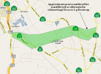 In late January 2010, the Gilroy Dispatch
reported that two county agencies are planning a $200-plus million project
to build a new connector from US 101 to Route 99. The Santa Clara Valley
Transportation Authority and Council of San Benito County Governments
formally created a memorandum of understanding 10/15/2010 regarding the
project, which is expected to cost $215 million to $284 million, according
to the San Benito COG. The new road - which could be a toll road or built
through a public-private partnership among other options - would obviate
Route 152 (it is unclear whether, at this point, it would be renumbered
Route 152 or be a parallel route). So far, the Santa Clara Valley
Transportation Authority has secured $10 million for the project,
including $5 million of its own money and $5 million from the state, but
future funding for the project—slated to be built within the next
decade - is still uncertain. Although, Santa Clara County Supervisor Don
Gage said there has been talk about realigning Route 152 for nearly 20
years, this is the first time an alignment route has been determined to
connect US 101 and Route 156 in northern San Benito County. According to
the article, the current two-lane portion of Route 152 near Gilroy would
likely be converted into a county roadway. The goal is to have the project
completed in the next 10 years, but she said that is not likely because of
the size and cost of the project. After the current study is done, she
said the next step is looking at alternatives for environmental work.
In late January 2010, the Gilroy Dispatch
reported that two county agencies are planning a $200-plus million project
to build a new connector from US 101 to Route 99. The Santa Clara Valley
Transportation Authority and Council of San Benito County Governments
formally created a memorandum of understanding 10/15/2010 regarding the
project, which is expected to cost $215 million to $284 million, according
to the San Benito COG. The new road - which could be a toll road or built
through a public-private partnership among other options - would obviate
Route 152 (it is unclear whether, at this point, it would be renumbered
Route 152 or be a parallel route). So far, the Santa Clara Valley
Transportation Authority has secured $10 million for the project,
including $5 million of its own money and $5 million from the state, but
future funding for the project—slated to be built within the next
decade - is still uncertain. Although, Santa Clara County Supervisor Don
Gage said there has been talk about realigning Route 152 for nearly 20
years, this is the first time an alignment route has been determined to
connect US 101 and Route 156 in northern San Benito County. According to
the article, the current two-lane portion of Route 152 near Gilroy would
likely be converted into a county roadway. The goal is to have the project
completed in the next 10 years, but she said that is not likely because of
the size and cost of the project. After the current study is done, she
said the next step is looking at alternatives for environmental work.
In February 2010, it was reported that regional transportation authorities hope to align the Route 152 realignment project with the future California High-Speed Rail system
In July 2017, Mr. Roadshow noted that the sales tax
approved by Santa Clara County voters last year will pay for new ramps at
the Route 25-US 101 interchange, which some day will be the start of a
four-lane freeway on Route 25 to that would hook north near Route 152 or
Route 156. The current two lanes of Route 152 from US 101 to Casa de Fruta
would likely remain as a frontage road. The cost of this isn’t
known, but it’s not going to be cheap. However, the gas and car fee
hikes approved by Gov. Brown and the state Legislature this year include
$500 million annually for congested corridors and truck routes.
(Source: Mercury News, 7/2/2017)
 In September 2020, it was reported that the Mobility
Partnership Committee of the Santa Clara Valley Transportation Authority
(VTA) and the Council of San Benito County Governments (COG) narrowed down
the new trade corridor project to two routes. The committee unanimously
voted to eliminate alternatives 1 and 4. The easternmost route
(alternative 3) connects Route 156 and Route 25 near Fairview Road and
east of Shore Road. The westernmost route (alternative 2) would connect
the highways near the Grove and west of Shore Road. The project would
replace Route 152 as the main route for trucks and connect it to Route 25.
The corridor aims to improve the movement of goods between the Central
Valley and northern Central Coast regions, improve commuter routes between
the Central Valley and employers in the San Francisco and Monterey Bay
areas, and improve regional and recreational travel. With 62 points,
alternative 2 was among the highest scoring in four of the seven
categories that include operations, multimodal (having several modes of
activity), access to economic centers, community acceptance and potential
for tolling. Stakeholders including the Economic Development Corporation
of San Benito County, the San Benito County Business Council and the San
Benito County Farm Bureau did not have a consensus on an option but
preferred alternatives 2 and 3 over the others. The concern with
alternative 1, the northernmost alignment, was that it was too close to
the existing alignment and that it would not benefit economic development
in San Benito County. The stakeholders also felt the southernmost
alignment, alternative 4, was too far out of the way and too close to the
US 101/ Route 156 interchange. The routes are not definite, but an
estimate of where they would be located.
In September 2020, it was reported that the Mobility
Partnership Committee of the Santa Clara Valley Transportation Authority
(VTA) and the Council of San Benito County Governments (COG) narrowed down
the new trade corridor project to two routes. The committee unanimously
voted to eliminate alternatives 1 and 4. The easternmost route
(alternative 3) connects Route 156 and Route 25 near Fairview Road and
east of Shore Road. The westernmost route (alternative 2) would connect
the highways near the Grove and west of Shore Road. The project would
replace Route 152 as the main route for trucks and connect it to Route 25.
The corridor aims to improve the movement of goods between the Central
Valley and northern Central Coast regions, improve commuter routes between
the Central Valley and employers in the San Francisco and Monterey Bay
areas, and improve regional and recreational travel. With 62 points,
alternative 2 was among the highest scoring in four of the seven
categories that include operations, multimodal (having several modes of
activity), access to economic centers, community acceptance and potential
for tolling. Stakeholders including the Economic Development Corporation
of San Benito County, the San Benito County Business Council and the San
Benito County Farm Bureau did not have a consensus on an option but
preferred alternatives 2 and 3 over the others. The concern with
alternative 1, the northernmost alignment, was that it was too close to
the existing alignment and that it would not benefit economic development
in San Benito County. The stakeholders also felt the southernmost
alignment, alternative 4, was too far out of the way and too close to the
US 101/ Route 156 interchange. The routes are not definite, but an
estimate of where they would be located.
(Source: BenitoLink, 9/12/2020)
In July 2010, the CTC approved for future consideration of funding a project that will construct roadway improvements on Route 152 at Lover’s Lane near the city of Gilroy (near 152 SCL R18.892). These improvements will include expanding sight distances, upgrading portions of the shoulders to current standards, and providing a left turn lane at the intersection of Route 152 and Lover’s Lane. The project is fully funded in the 2010 State Highway Operation and Protection Program. Construction is estimated to begin in Fiscal Year 2010-11. Total estimated project cost is $22,770,000 for capital and support.
In January 2007, the CTC considered a project to construct an eastbound truck climbing lane with rumble strip on Route 152 from east of San Felipe Road (appx. 152 SCL R19.687) to west of Route 152/156 Junction (apx. 152 SCL 21.747).
The SAFETEA-LU act, enacted in August 2005 as the reauthorization of TEA-21, provided the following expenditures on or near this route (near 152 SCL R21.967):
In May 2013, the CTC relinquished right of way in the county of Santa Clara along Route 152 at Walnut Avenue, consisting of collateral facilities. (approx 152 SCL R22.751)
In April 2010, the CTC approved relinquishment of right of way in the county of Santa Clara along Route 152 and Casa De Fruta Parkway, consisting of superseded highway right of way and collateral facilities. (somewhere near 152 SCL R23.776)
Pacheco Pass Wildlife Crossing (~ SCL R34.835)
In April 2022, it was reported that the California
High-Speed Rail Authority (Authority) and the Santa Clara Valley Habitat
Agency, along with partners from Caltrans, the Santa Clara Valley
Transportation Authority (VTA) and Pathways for Wildlife, were awarded a
$3.125 million grant to continue efforts to protect wildlife movement in
Northern California. The California Wildlife Conservation Board
grant will fund the planning, design, environmental review and permitting
of a proposed wildlife overcrossing spanning Route 152, near the San Jose
to Merced high-speed rail project section. The grant will support four
years to advance planning and environmental review for the proposed
overcrossing, which includes conducting a habitat modeling analysis,
completing a feasibility study, preparing a project initiation report
under Caltrans’ oversight and advancing the project to 65% design.
With additional funding, the Habitat Agency would also oversee the
preparation of an environmental document under the California
Environmental Quality Act that will evaluate at least two build
alternatives. Pathways for Wildlife has worked with the Santa Clara Valley
Habitat Agency for the past three years conducting a wildlife connectivity
study along Route 152 in the Pacheco Pass and within the Habitat
Agency’s property, the Pacheco Creek Reserve. Environmental approval
of the Authority’s San Jose to Merced project section through the
Pacheco Pass will be considered at the Authority’s Board Meeting on
April 27 and 28, 2022.
(Source: High Speed Rail Authority News Release, 4/19/2022)
Median Barrier: Basalt Road to I-5 (10-Mer-152 R10.1/13.848)
 In January 2021, the CTC amended the following project into the SHOPP: (1a)
#15 10-Mer-152 R10.1/13.848 PPNO 3505 ProjID 1020000085 EA 1L630. Route 152 near Los Banos, from 0.8 mile west Basalt Road to Route 5. Construct
median barrier. PA&ED $1,010K; PS&E $1,070K;R/W Sup $138K; Con Sup
$1,130K; R/W Cap $110K; Const Cap $6,407 TOTAL $9,865K. Begin const.
10/28/2024.
In January 2021, the CTC amended the following project into the SHOPP: (1a)
#15 10-Mer-152 R10.1/13.848 PPNO 3505 ProjID 1020000085 EA 1L630. Route 152 near Los Banos, from 0.8 mile west Basalt Road to Route 5. Construct
median barrier. PA&ED $1,010K; PS&E $1,070K;R/W Sup $138K; Con Sup
$1,130K; R/W Cap $110K; Const Cap $6,407 TOTAL $9,865K. Begin const.
10/28/2024.
(Source: January 2021 CTC Agenda, Agenda Item
2.1a.(1a) #11)
In January 2021, the CTC approved the following
pre-construction support phase allocation(s): (2a) #34. $1,010,000
(PA&ED). 10-Mer-152 R10.1/13.848. PPNO 10-3505; ProjID 1020000085; EA
1L630. Route 152 Near Los Banos, from 0.8 mile west Basalt Road to Route 5. Construct median barrier. (Concurrent Amendment under SHOPP Amendment
20H-005; January 2021.) Prog Year 23-24.
(Source: January 2021 CTC Agenda, Agenda Item
2.5b.(2a) #34)
In February 2002, the CTC relinquied the following segments of the
original routing may have been relinquished: PM 11.3 to PM 11.7 in the
County of Merced; PM 19.6 to PM 21.3 in the City of Los Baños.
(Source: CTC February 2002 Agenda Item 2.3c)
Truck Turn Radius Improvements (10-Mer-152 11.3, 10-Mer-5 6.3)
The following project was included in the final adopted 2018 SHOPP in March 2018: PPNO 3214. 10-Merced-152 11.3. Route 152 Near Los Banos, at Route 33 Interchange; also on Route 5 (PM 6.3) at Route 165 Interchange. Improve the truck turn radius. Begin Con: 6/15/2022. Total Project Cost: $4,529K.
In August 2020, the CTC approved the following
financial allocation: $64,000 for R/W Sup. 10-Mer-152 PM 11.2. PPNO 3214
ProjID 1017000005 EA 0T680. Route 152 Near Los Banos, at Route 33
Interchange; also Route 5 (PM 6.3) at Route 165 Interchange. Improve the
truck turn radius.
(Source: August 2020 CTC Agenda, Agenda Item
2.5b.(2a) #32)
In January 2022, the CTC approved the following SHOPP
allocation: $3,220,000. 10-Mer-152 11.3. PPNO 10-3214; ProjID 1017000005;
EA 0T680. Route 152 Near Los Banos, at Route 33 Interchange; also on Route 5 (PM 6.3) at Route 165 Interchange. Outcome/Output: Improve the
truck turning radius at two locations by widening ramps, upgrade
guardrail, and install lighting. Allocation: CON ENG $630,000; CONST
$2,216,000.
(Source: January 2022 CTC Agenda, Agenda Item
2.5b.(1) #14)
Los Baños Bypass (MER 16.0 to MER 24.8)
![[Map]](maps/152-losbanos.jpg) With respect to the Los Baños bypass,
the CTC in November 2007 considered a project for future funding. The
project would construct a new bypass along a portion of Route 152 near Los
Baños (MER 16.0 to MER 24.8). A route adoption has been proposed, and
the project has been approved for construction. Route studies to construct
a bypass on Route 152 around the City of Los Baños were initiated in
1962. As a result of these studies, a southern bypass route was adopted by
the California Highway Commission on April 28, 1965. Due to funding
concerns, a portion of this adopted route (from Baños Creek to San
Luis Canal) was rescinded in 1981. In 1987, as congestion and safety
became concern along Route 152, the bypass concept was reinitiated. In
1988, a Major Investment Study ( was prepared by the Merced County
Association of Governments (MCAG) with support from the County of Merced,
City of Los Baños, the Department (D10), FHWA, and other agencies.
Many alternatives were considered and rejected. In 1999, initial funding
was obtained and environmental studies were initiated. Finally, on June
25, 2007, the environmental document was approved and proposed northern
bypass route alternative was selected. This alternative avoids wetlands,
historic properties, the City’s planned industrial park, and the
proposed airport relocation site. Portions of the freeway route adoption
from April 28, 1965, will be rescinded as part of this proposed freeway
route adoption as shown on the route location map. The proposed project is
to construct a four-lane freeway bypass within an ultimate six-lane right
of way for Route 152 around and through the city of Los Baños. The
freeway would begin approximately at Post Mile 16.0, east of Volta Road,
and end approximately at Post Mile 24.8, east of the Old Santa Fe Grade
Road. Three spread diamond type interchanges are proposed. The first
interchange will be located just east of Ramos Road, the second
interchange will be at the intersection of Route 152 with Route 165, and
the third interchange will be located just west of Old Santa Fe Grade
Road. Frontage roads would be constructed as needed to provide access to
landlocked parcels. Relinquishment of the existing Route 152 would occur
after construction of the new bypass. Relinquishment would transfer the
State’s right of way, title, and interest of a section of Route 152
to the City of Los Baños and to Merced County.
With respect to the Los Baños bypass,
the CTC in November 2007 considered a project for future funding. The
project would construct a new bypass along a portion of Route 152 near Los
Baños (MER 16.0 to MER 24.8). A route adoption has been proposed, and
the project has been approved for construction. Route studies to construct
a bypass on Route 152 around the City of Los Baños were initiated in
1962. As a result of these studies, a southern bypass route was adopted by
the California Highway Commission on April 28, 1965. Due to funding
concerns, a portion of this adopted route (from Baños Creek to San
Luis Canal) was rescinded in 1981. In 1987, as congestion and safety
became concern along Route 152, the bypass concept was reinitiated. In
1988, a Major Investment Study ( was prepared by the Merced County
Association of Governments (MCAG) with support from the County of Merced,
City of Los Baños, the Department (D10), FHWA, and other agencies.
Many alternatives were considered and rejected. In 1999, initial funding
was obtained and environmental studies were initiated. Finally, on June
25, 2007, the environmental document was approved and proposed northern
bypass route alternative was selected. This alternative avoids wetlands,
historic properties, the City’s planned industrial park, and the
proposed airport relocation site. Portions of the freeway route adoption
from April 28, 1965, will be rescinded as part of this proposed freeway
route adoption as shown on the route location map. The proposed project is
to construct a four-lane freeway bypass within an ultimate six-lane right
of way for Route 152 around and through the city of Los Baños. The
freeway would begin approximately at Post Mile 16.0, east of Volta Road,
and end approximately at Post Mile 24.8, east of the Old Santa Fe Grade
Road. Three spread diamond type interchanges are proposed. The first
interchange will be located just east of Ramos Road, the second
interchange will be at the intersection of Route 152 with Route 165, and
the third interchange will be located just west of Old Santa Fe Grade
Road. Frontage roads would be constructed as needed to provide access to
landlocked parcels. Relinquishment of the existing Route 152 would occur
after construction of the new bypass. Relinquishment would transfer the
State’s right of way, title, and interest of a section of Route 152
to the City of Los Baños and to Merced County.
![[Los Banos - 3 Segments]](maps/152-losbanos3.jpg) In February 2009, the CTC approved splitting the Los Baños into three segments for funding
reasons. The problem is that the construction estimate for the Los
Baños Bypass (including construction support) is $409 million, which
was too large to program in a single STIP cycle. Rather than design the
entire bypass, which cannot be constructed as a single project, the opted
to design and acquire right of way for a fundable segment with independent
utility (Segment 1). As such, they split the project into three segments
as follows:
In February 2009, the CTC approved splitting the Los Baños into three segments for funding
reasons. The problem is that the construction estimate for the Los
Baños Bypass (including construction support) is $409 million, which
was too large to program in a single STIP cycle. Rather than design the
entire bypass, which cannot be constructed as a single project, the opted
to design and acquire right of way for a fundable segment with independent
utility (Segment 1). As such, they split the project into three segments
as follows:
As of February 2009, only PPNO 5707A (Segment 1) was funded.
In February 2012, it was reported that the Los Baños bypass may be a toll road. In particular, the California Transportation Commission is considering a plan to add toll booths to the highway in order to pay for a new four lane road between Casa De Fruta and Gilroy, and also a long-awaited bypass around Los Banos. The Merced County Association of Governments says toll booths may be the only way to pay for the $420 million bypass. But first, it's being asked to contribute $7 million toward the overall environmental review process, money that was set aside specifically for the bypass.
In February 2018, Caltrans District 10 reported that they recently
completed a $3.3 million project installing a median barrier on Route 152
spaning 3.6 miles from two miles west of Los Baños from Vista Point
Access Road to San Luis Dam Service Road near Dinosaur Point.
(Source: Facebook, 2/5/2018)
Unconstructed from Route 99 (apx. 152 MAD 15.611) to
(unconstructed) Route 65 near Sharon. There is no traversable local
routing in this segment, and no recommendations for a routing.
Naming This segment is named "Pacheco Pass Road". Pacheco Pass is a mountain pass at an elevation of 417m (1,368ft) above
the sea level, located in the Diablo Range in southeastern Santa Clara
County, California. The area was named after Don Francisco Perez
Pacheco who received a large land grant from Mexico that covered a large
area that now includes the pass for which he is named. According to a historical plaque at the visitor's center near the San Luis Reservoir: "On June 21, 1805, Lieutenant Gabriel Moraga, on his first
exploratory journey into the San Joaquin Valley, traversed this pass and
recorded it. Since then it has been trail, toll road, stagecoach road, and
freeway -- the principal route between the coastal areas to the west and
the great valley and mountains to the east."
This segment is named "Pacheco Pass Road". Pacheco Pass is a mountain pass at an elevation of 417m (1,368ft) above
the sea level, located in the Diablo Range in southeastern Santa Clara
County, California. The area was named after Don Francisco Perez
Pacheco who received a large land grant from Mexico that covered a large
area that now includes the pass for which he is named. According to a historical plaque at the visitor's center near the San Luis Reservoir: "On June 21, 1805, Lieutenant Gabriel Moraga, on his first
exploratory journey into the San Joaquin Valley, traversed this pass and
recorded it. Since then it has been trail, toll road, stagecoach road, and
freeway -- the principal route between the coastal areas to the west and
the great valley and mountains to the east."
(Image source: Flikr; Find a Grave)
 Memorial Highway") The portion of Route 152 between its intersection with Route 233 and its
intersection with Route 99 (MAD 10.799 to MAD 15.622) in the County of
Madera is named the Bill Whitehurst Memorial Highway (signed as
"William S. Whitehurst "Bill" Memorial Highway"). It was named in
memory of William “Bill” S. Whitehurst,a prominent Fresno
businessman, civic leader, philanthropist, and devoted and generous member
of the community, actively involved in local organizations such as the Boy
Scouts of America, the Knights of Columbus, the Fresno Arts Center, and
Veterans of Foreign Wars. Whitehurst was born in 1922 in Sacramento, and
that same year the family moved to Los Banos to open a funeral home. Bill
Whitehurst, his brother, Joel, and his sister, Betty, graduated from Los
Banos High School, where he lettered in football, basketball, and baseball
while maintaining straight As. Whitehurst received a football scholarship
from St. Mary’s College of California in Moraga, which is
administered by the De LaSalle Christian Brothers. He cherished his time
at St. Mary’s College and throughout his lifetime provided
scholarships to the students of St. Mary’s and San Joaquin Memorial
High School, which is also administered by Christian Brothers. In 1973,
Bill Whitehurst received the Christian Brothers’ prestigious award
of Signum Fidei for his outstanding participation in the goals of higher
education. After assuming ownership of his family’s Whitehurst
Chapel at 18 years of age, Bill Whitehurst served two years overseas
during World War II in the United States Army and was honorably
discharged. Bill Whitehurst has demonstrated a lifetime of public service
and a commitment to his community, beginning with his election to the Los
Banos City Council at 21 years of age. He was selected county campaign
chairman for Governor Edmund G. Brown’s bid for Governor in 1962,
and as county campaign chairman for John F. Kennedy in 1960 and Lyndon B.
Johnson in 1964 in their bids for the presidency. Whitehurst was appointed
to the State Highway Commission in 1963 and served until 1970, where he
spearheaded a drive to transform Route 152, then a dangerous two-lane
highway known as “Blood Alley” due to numerous traffic
accidents, into a safer four-lane highway. In 1970, Bill Whitehurst was
given the Department of Veterans Affairs Citation of Merit for his ongoing
generosity shown by his performing burials of disabled veterans who died
at a Veterans Affairs hospital at a cost not exceeding the Veterans
Administration’s allowance. In 1970, and through the year 2012, Bill
Whitehurst extended that courtesy to any veteran who died under difficult
financial circumstances. From 1971 to 1972, Bill Whitehurst served two
terms as President of the American Cancer Society. From 1973 to 1982, Bill
Whitehurst served as a member of the Saint Agnes Medical Center Board of
Trustees and helped drive the movement to relocate the medical center to
its current location in north Fresno. To do this, Bill Whitehurst helped
secure the donation of the 30-acre property and generously donated his own
money to the building fund. In 1973, Bill Whitehurst developed the Safe-D
Program to help young teenagers improve their driving skills and become
more aware of the obligations and responsibilities of driving a motor
vehicle. Throughout his lifetime, Bill Whitehurst remained devoted to his
church, and in 1989 received the prestigious Benemerenti medal from Pope
John Paul II, for outstanding service to his church, his community, and to
families in need. On July 20, 2000, Bill Whitehurst and his wife, Ann,
conveyed to the Fresno County Office of Education the property known as
Scout Island, a parcel that was key in developing the San Joaquin River
Parkway and is now used as an outdoor education center. Bill Whitehurst
continued his commitment to the community by serving on the St.
John’s Cathedral Restoration project, helping to raise the needed
moneys necessary to keep the historic cathedral, which is located in
Fresno, a jewel for the entire San Joaquin Valley. Named by Senate
Concurrent Resolution 36, August 15, 2013. Resolution Chapter 71.
The portion of Route 152 between its intersection with Route 233 and its
intersection with Route 99 (MAD 10.799 to MAD 15.622) in the County of
Madera is named the Bill Whitehurst Memorial Highway (signed as
"William S. Whitehurst "Bill" Memorial Highway"). It was named in
memory of William “Bill” S. Whitehurst,a prominent Fresno
businessman, civic leader, philanthropist, and devoted and generous member
of the community, actively involved in local organizations such as the Boy
Scouts of America, the Knights of Columbus, the Fresno Arts Center, and
Veterans of Foreign Wars. Whitehurst was born in 1922 in Sacramento, and
that same year the family moved to Los Banos to open a funeral home. Bill
Whitehurst, his brother, Joel, and his sister, Betty, graduated from Los
Banos High School, where he lettered in football, basketball, and baseball
while maintaining straight As. Whitehurst received a football scholarship
from St. Mary’s College of California in Moraga, which is
administered by the De LaSalle Christian Brothers. He cherished his time
at St. Mary’s College and throughout his lifetime provided
scholarships to the students of St. Mary’s and San Joaquin Memorial
High School, which is also administered by Christian Brothers. In 1973,
Bill Whitehurst received the Christian Brothers’ prestigious award
of Signum Fidei for his outstanding participation in the goals of higher
education. After assuming ownership of his family’s Whitehurst
Chapel at 18 years of age, Bill Whitehurst served two years overseas
during World War II in the United States Army and was honorably
discharged. Bill Whitehurst has demonstrated a lifetime of public service
and a commitment to his community, beginning with his election to the Los
Banos City Council at 21 years of age. He was selected county campaign
chairman for Governor Edmund G. Brown’s bid for Governor in 1962,
and as county campaign chairman for John F. Kennedy in 1960 and Lyndon B.
Johnson in 1964 in their bids for the presidency. Whitehurst was appointed
to the State Highway Commission in 1963 and served until 1970, where he
spearheaded a drive to transform Route 152, then a dangerous two-lane
highway known as “Blood Alley” due to numerous traffic
accidents, into a safer four-lane highway. In 1970, Bill Whitehurst was
given the Department of Veterans Affairs Citation of Merit for his ongoing
generosity shown by his performing burials of disabled veterans who died
at a Veterans Affairs hospital at a cost not exceeding the Veterans
Administration’s allowance. In 1970, and through the year 2012, Bill
Whitehurst extended that courtesy to any veteran who died under difficult
financial circumstances. From 1971 to 1972, Bill Whitehurst served two
terms as President of the American Cancer Society. From 1973 to 1982, Bill
Whitehurst served as a member of the Saint Agnes Medical Center Board of
Trustees and helped drive the movement to relocate the medical center to
its current location in north Fresno. To do this, Bill Whitehurst helped
secure the donation of the 30-acre property and generously donated his own
money to the building fund. In 1973, Bill Whitehurst developed the Safe-D
Program to help young teenagers improve their driving skills and become
more aware of the obligations and responsibilities of driving a motor
vehicle. Throughout his lifetime, Bill Whitehurst remained devoted to his
church, and in 1989 received the prestigious Benemerenti medal from Pope
John Paul II, for outstanding service to his church, his community, and to
families in need. On July 20, 2000, Bill Whitehurst and his wife, Ann,
conveyed to the Fresno County Office of Education the property known as
Scout Island, a parcel that was key in developing the San Joaquin River
Parkway and is now used as an outdoor education center. Bill Whitehurst
continued his commitment to the community by serving on the St.
John’s Cathedral Restoration project, helping to raise the needed
moneys necessary to keep the historic cathedral, which is located in
Fresno, a jewel for the entire San Joaquin Valley. Named by Senate
Concurrent Resolution 36, August 15, 2013. Resolution Chapter 71.
(Image source:Gribblenation; Dignity Memorial)
 The portion of Route 152 that runs through the City of Los Banos, from the entrance of
the Los Banos Campus of Merced College (MER 17.995) to San Luis Street
(MER 22.874) in the County of Merced, is named the "Joe Cox Memorial
Highway". It was named in memory of Joe Cox, who saw a lot in his
life: the fields of Arkansas, the roads of America on the way to
California, the waters off Japan in a submarine, the snows of Alaska, the
coasts of Korea in wartime, and the relative calm of Los Banos. Joe worked
as a farmer, an agriculture teacher, and a principal. He did more in his
retirement than many people do in a lifetime: President of the Los Banos
Golden Agers, Chairman of the Board of the Los Banos Unified School
District, District Governor in Rotary, Chair of the California Senior
Legislature, and most recently National President of the U.S. Submarine
Veterans of World War II. Although he accomplished much in California, Joe
was a native of Arkansas, born in 1925 in Booneville. As a kid he did
chores on the farm where his family lived until he was six. Then in 1932,
during the Great Depression, his family decided to leave Arkansas. His
family landed in Reedley in the County of Fresno, where a cousin of
Joe’s lived in a tent. The Cox family moved into the next tent over.
They lived in tents for the following year before Joe’s dad found a
place to rent in Reedley. After graduating from Wahtoke Grammar School,
Joe went to Reedley High. But he wasn’t through moving as his family
relocated to Parlier. Joe enrolled in Parlier High School where he was
active in sports, including football, basketball, and track, and stayed
until he graduated in December of 1944. By then Joe was 18, it was World
War II, and he was eligible for the draft. He decided to enlist in the
Navy. While in the Navy, Joe went to submarine school and was assigned to
a tender ship, the U.S.S. Orion, which served as a repair station for
subs. Later he was assigned to submarine U.S.S. Batfish, patrolling off
the coasts of Japan, with the particular mission of
“lifeguarding,” finding pilots whose planes had been shot down
and who had parachuted into the sea. After the war and after he was
discharged, Joe returned to Reedley, where he saw a newspaper
advertisement for radio operators to work for Pan American Airways in
Fairbanks, Alaska. Joe applied, got the job, and worked in Alaska for two
years. After working and living in Alaska, Joe returned to Reedley and
joined his brother-in-law who had gone into farming. After several years
of farming in the Central Valley, from Reedley to Madera, Joe enrolled in
Reedley College, graduated with an associate of arts degree, and then
transferred to California Polytechnic State University (Cal Poly) in San
Luis Obispo. Joe, who had earlier signed up for the Naval Reserve, was in
his first quarter at Cal Poly when he was called up to active duty to
serve in the Korean War. He was assigned to the U.S.S. McDermut, a
destroyer that was positioned off the shores of Korea and shelled coastal
cities. After two years of wartime service, Joe returned to Cal Poly and
completed his degree. He continued there to complete his teaching
credential, including a semester as an intern or “cadet” at
Strathmore High School near Porterville. Later, Joe accepted an
agriculture science teaching position at Los Banos High School and later
became the agriculture department chair. He turned the agriculture
department, which had not been doing well, into a highly respected
program. In the spring of 1963, Joe led the Los Banos High School team to
a first place finish in the state dairy judging contest, and then on to
Waterloo, Iowa, where the team won the national dairy judging contest.
Meanwhile, Joe continued to take summer classes to prepare for other job
opportunities in education. He earned a master’s degree in education
from Cal Poly in 1957. Later, in 1981, he earned his doctoral degree in
education from the University of Southern California. In the summer of
1963, Joe was named assistant principal of Los Banos High School. One of
Joe’s many jobs was to direct the adult education program. When
Merced College replaced Modesto Junior College in offering college classes
locally, Joe was hired by Merced College to run the evening program. Joe
helped set the stage for the first complete campus when the Los Banos
Campus of Merced College opened its doors in 1971. In 1969, Joe was named
principal of Los Banos High School. He served as principal there until
1982, when he was transferred to the junior high school. Joe retired in
1988, ran for the school board, was elected, and then served on the school
board for 12 years. After his retirement Joe was active in many different
organizations. In each case Joe became a leader: President of the Los
Banos Golden Agers, Chairman of the Board of the Los Banos Unified School
District, District Governor in Rotary, Chair of the California Senior
Legislature, and National President of the U.S. Submarine Veterans of
World War II. Joe believed that the motto of every retired person should
be “Stay Active. Get Involved.” In that way, Joe said,
“They are not only helping others, they are keeping themselves
healthy”. Over the years Joe stayed active, stayed healthy, and used
his talents to help organizations stay healthy too. His life was one of
service to others, from the days on a submarine in World War II right up
to his passing on January 22, 2018, as a result of a car crash on Route 152. Named by Assembly Concurrent Resolution (ACR) 224, Res. Chapter 155,
8/17/2018.
The portion of Route 152 that runs through the City of Los Banos, from the entrance of
the Los Banos Campus of Merced College (MER 17.995) to San Luis Street
(MER 22.874) in the County of Merced, is named the "Joe Cox Memorial
Highway". It was named in memory of Joe Cox, who saw a lot in his
life: the fields of Arkansas, the roads of America on the way to
California, the waters off Japan in a submarine, the snows of Alaska, the
coasts of Korea in wartime, and the relative calm of Los Banos. Joe worked
as a farmer, an agriculture teacher, and a principal. He did more in his
retirement than many people do in a lifetime: President of the Los Banos
Golden Agers, Chairman of the Board of the Los Banos Unified School
District, District Governor in Rotary, Chair of the California Senior
Legislature, and most recently National President of the U.S. Submarine
Veterans of World War II. Although he accomplished much in California, Joe
was a native of Arkansas, born in 1925 in Booneville. As a kid he did
chores on the farm where his family lived until he was six. Then in 1932,
during the Great Depression, his family decided to leave Arkansas. His
family landed in Reedley in the County of Fresno, where a cousin of
Joe’s lived in a tent. The Cox family moved into the next tent over.
They lived in tents for the following year before Joe’s dad found a
place to rent in Reedley. After graduating from Wahtoke Grammar School,
Joe went to Reedley High. But he wasn’t through moving as his family
relocated to Parlier. Joe enrolled in Parlier High School where he was
active in sports, including football, basketball, and track, and stayed
until he graduated in December of 1944. By then Joe was 18, it was World
War II, and he was eligible for the draft. He decided to enlist in the
Navy. While in the Navy, Joe went to submarine school and was assigned to
a tender ship, the U.S.S. Orion, which served as a repair station for
subs. Later he was assigned to submarine U.S.S. Batfish, patrolling off
the coasts of Japan, with the particular mission of
“lifeguarding,” finding pilots whose planes had been shot down
and who had parachuted into the sea. After the war and after he was
discharged, Joe returned to Reedley, where he saw a newspaper
advertisement for radio operators to work for Pan American Airways in
Fairbanks, Alaska. Joe applied, got the job, and worked in Alaska for two
years. After working and living in Alaska, Joe returned to Reedley and
joined his brother-in-law who had gone into farming. After several years
of farming in the Central Valley, from Reedley to Madera, Joe enrolled in
Reedley College, graduated with an associate of arts degree, and then
transferred to California Polytechnic State University (Cal Poly) in San
Luis Obispo. Joe, who had earlier signed up for the Naval Reserve, was in
his first quarter at Cal Poly when he was called up to active duty to
serve in the Korean War. He was assigned to the U.S.S. McDermut, a
destroyer that was positioned off the shores of Korea and shelled coastal
cities. After two years of wartime service, Joe returned to Cal Poly and
completed his degree. He continued there to complete his teaching
credential, including a semester as an intern or “cadet” at
Strathmore High School near Porterville. Later, Joe accepted an
agriculture science teaching position at Los Banos High School and later
became the agriculture department chair. He turned the agriculture
department, which had not been doing well, into a highly respected
program. In the spring of 1963, Joe led the Los Banos High School team to
a first place finish in the state dairy judging contest, and then on to
Waterloo, Iowa, where the team won the national dairy judging contest.
Meanwhile, Joe continued to take summer classes to prepare for other job
opportunities in education. He earned a master’s degree in education
from Cal Poly in 1957. Later, in 1981, he earned his doctoral degree in
education from the University of Southern California. In the summer of
1963, Joe was named assistant principal of Los Banos High School. One of
Joe’s many jobs was to direct the adult education program. When
Merced College replaced Modesto Junior College in offering college classes
locally, Joe was hired by Merced College to run the evening program. Joe
helped set the stage for the first complete campus when the Los Banos
Campus of Merced College opened its doors in 1971. In 1969, Joe was named
principal of Los Banos High School. He served as principal there until
1982, when he was transferred to the junior high school. Joe retired in
1988, ran for the school board, was elected, and then served on the school
board for 12 years. After his retirement Joe was active in many different
organizations. In each case Joe became a leader: President of the Los
Banos Golden Agers, Chairman of the Board of the Los Banos Unified School
District, District Governor in Rotary, Chair of the California Senior
Legislature, and National President of the U.S. Submarine Veterans of
World War II. Joe believed that the motto of every retired person should
be “Stay Active. Get Involved.” In that way, Joe said,
“They are not only helping others, they are keeping themselves
healthy”. Over the years Joe stayed active, stayed healthy, and used
his talents to help organizations stay healthy too. His life was one of
service to others, from the days on a submarine in World War II right up
to his passing on January 22, 2018, as a result of a car crash on Route 152. Named by Assembly Concurrent Resolution (ACR) 224, Res. Chapter 155,
8/17/2018.
(Image source: Caltrans Dist. 10 on FB; Merced Sun Star)
 The portion of Route 152, west of Road 10 from PM MAD 2.350 to MAD 7.350, in
the County of Madera is named the “California Highway Patrol
Officer Charles D. Goss Memorial Highway”. It was named in
memory of California Highway Patrol Officer Charles Donald Goss, who was
born in October 1916 in Jamestown, California. Goss graduated from Sonora
Union High School in 1934, and attended the California State University,
San Francisco shortly thereafter. Goss was in the United States Navy
Reserve, Boatswain Mate Second Class (WWII) and worked for the Bell
Telephone Company. Goss (Badge № 1307) graduated from the California
Highway Patrol Academy in 1952, and was assigned to the area of the County
of Madera, where he proudly served for three years and five months. On
November 25, 1955, Officer Goss responded to a traffic collision west of
the City of Chowchilla and was transporting four men to the hospital when
a vehicle attempted to pass a truck in the opposite direction and collided
head-on with Officer Goss, killing him instantly. Named by Assembly
Resolution ACR 89, Res. Chapter 122, 08/19/22).
The portion of Route 152, west of Road 10 from PM MAD 2.350 to MAD 7.350, in
the County of Madera is named the “California Highway Patrol
Officer Charles D. Goss Memorial Highway”. It was named in
memory of California Highway Patrol Officer Charles Donald Goss, who was
born in October 1916 in Jamestown, California. Goss graduated from Sonora
Union High School in 1934, and attended the California State University,
San Francisco shortly thereafter. Goss was in the United States Navy
Reserve, Boatswain Mate Second Class (WWII) and worked for the Bell
Telephone Company. Goss (Badge № 1307) graduated from the California
Highway Patrol Academy in 1952, and was assigned to the area of the County
of Madera, where he proudly served for three years and five months. On
November 25, 1955, Officer Goss responded to a traffic collision west of
the City of Chowchilla and was transporting four men to the hospital when
a vehicle attempted to pass a truck in the opposite direction and collided
head-on with Officer Goss, killing him instantly. Named by Assembly
Resolution ACR 89, Res. Chapter 122, 08/19/22).
(Image source: CHP Memorial Page)
 Named Structures
 The flyover ramp at the interchange of Route 152 and Route 156 is named the “Joseph A. Zanger
Memorial Flyover”. This segment was named in honor of Joseph
A. Zanger, who was born on December 28, 1927, in San Jose, California.
After attending college, Joseph moved to the Pacheco Pass area to help
manage his family's orchard operations. In 1943, the Zanger family founded
Casa de Fruta to complement its farming business. The Casa de Fruta
business started with a small cherry stand built in 1943 and grew to
include a large fruit stand, a restaurant, a park for recreational
vehicles, a lodge, wine tasting, a gift shop, a barnyard zoo, a candy
store, a service station, and a dried fruit mail order business. Joseph
studied safety and economic issues related to the transportation system of
central California and served as an advocate for the improvement of
transportation in that area. In 1978, Joseph served on the planning
committee for the I-5 project from Stockton to Santa Nella/Route 152. In
2005, Joseph also worked to establish a new route from Route 152/Route 156
to US 101. Joseph's advocacy for safety and transportation improvements
has affected thousands of motorists. Named by Senate Concurrent Resolution
(SCR) 85, Resolution Chapter 67, on 8/4/2010.
The flyover ramp at the interchange of Route 152 and Route 156 is named the “Joseph A. Zanger
Memorial Flyover”. This segment was named in honor of Joseph
A. Zanger, who was born on December 28, 1927, in San Jose, California.
After attending college, Joseph moved to the Pacheco Pass area to help
manage his family's orchard operations. In 1943, the Zanger family founded
Casa de Fruta to complement its farming business. The Casa de Fruta
business started with a small cherry stand built in 1943 and grew to
include a large fruit stand, a restaurant, a park for recreational
vehicles, a lodge, wine tasting, a gift shop, a barnyard zoo, a candy
store, a service station, and a dried fruit mail order business. Joseph
studied safety and economic issues related to the transportation system of
central California and served as an advocate for the improvement of
transportation in that area. In 1978, Joseph served on the planning
committee for the I-5 project from Stockton to Santa Nella/Route 152. In
2005, Joseph also worked to establish a new route from Route 152/Route 156
to US 101. Joseph's advocacy for safety and transportation improvements
has affected thousands of motorists. Named by Senate Concurrent Resolution
(SCR) 85, Resolution Chapter 67, on 8/4/2010.
(Image source: Gilroy Dispatch)
 Bridge 39-0145 over the O'Neill Forebay in Merced County (MER R010.05) is
officially designated the "Celano-Norris Memorial Bridge. It was
built in 1964, and was named by Assembly Concurrent Resolution No. 92,
Chapter 97, in 1994. Sergeant Frank Anthony Celano was a casualty of the
Vietnam War. As a member of the Army, SGT Celano served our country until
January 22nd, 1971 in Binh Hoa, South Vietnam. He was 21 years old and was
not married. Frank died when his helicopter crashed into the land. Frank
was born on July 19th, 1949 in Los Baños, California. Second
Lieutenant John Alexander Norris III was also a casualty of the
Vietnam War. As a member of the Marine Corps Reserve, 2LT Norris served
our country until October 4th, 1967 in Quang Nam, South Vietnam. He was 25
years old and was married. John died from small arms fire. John was born
on June 20th, 1942 in Los Baños, California.
Bridge 39-0145 over the O'Neill Forebay in Merced County (MER R010.05) is
officially designated the "Celano-Norris Memorial Bridge. It was
built in 1964, and was named by Assembly Concurrent Resolution No. 92,
Chapter 97, in 1994. Sergeant Frank Anthony Celano was a casualty of the
Vietnam War. As a member of the Army, SGT Celano served our country until
January 22nd, 1971 in Binh Hoa, South Vietnam. He was 21 years old and was
not married. Frank died when his helicopter crashed into the land. Frank
was born on July 19th, 1949 in Los Baños, California. Second
Lieutenant John Alexander Norris III was also a casualty of the
Vietnam War. As a member of the Marine Corps Reserve, 2LT Norris served
our country until October 4th, 1967 in Quang Nam, South Vietnam. He was 25
years old and was married. John died from small arms fire. John was born
on June 20th, 1942 in Los Baños, California.
(Image source: Vitural Wall (Celano); Fold 3)
 Bridge 39-0036 over the California Aqueduct in Merced County (MER 014.17), east of the
intersection with Route 5, officially designated the "Sandvig-Scanlon
Memorial Bridge". It was built in 1965, and was named by Assembly
Concurrent Resolution No. 92, Chapter 97, in 1994. Sergeant Vernon Dale
Sandvig was a casualty of the Vietnam War. As a member of the Army
Selective Service, SGT Sandvig served our country until March 28th, 1968
in Binh Duong, South Vietnam. He was 20 years old and was not married.
Vernon died from suffocation. Vernon was born on October 17th, 1947 in Los
Baños, California. Sergeant William Manuel Scanlon, was also a
casualty of the Vietnam War. As a member of the Army Selective Service,
SGT Scanlon served our country until August 8th, 1970 in Quang, Ngai,
South Vietnam. He was 21 years old and was not married. William died from
an undetermined explosion. William was born on March 11th, 1949 in Los
Baños, California.
Bridge 39-0036 over the California Aqueduct in Merced County (MER 014.17), east of the
intersection with Route 5, officially designated the "Sandvig-Scanlon
Memorial Bridge". It was built in 1965, and was named by Assembly
Concurrent Resolution No. 92, Chapter 97, in 1994. Sergeant Vernon Dale
Sandvig was a casualty of the Vietnam War. As a member of the Army
Selective Service, SGT Sandvig served our country until March 28th, 1968
in Binh Duong, South Vietnam. He was 20 years old and was not married.
Vernon died from suffocation. Vernon was born on October 17th, 1947 in Los
Baños, California. Sergeant William Manuel Scanlon, was also a
casualty of the Vietnam War. As a member of the Army Selective Service,
SGT Scanlon served our country until August 8th, 1970 in Quang, Ngai,
South Vietnam. He was 21 years old and was not married. William died from
an undetermined explosion. William was born on March 11th, 1949 in Los
Baños, California.
(Image source: HonorStates.Org; Wall of Faces)
Scenic Route Freeway
[SHC 253.7] From Route 101 to Route 65 near Sharon via Pacheco Pass. Added to the Freeway and Expressway system in 1959. There are no plans to construct this as freeway between Route 99 and (unconstructed) Route 65 near Sharon.
 Double Fine Zones
Between the junction with Route 156 at the Don Pacheco "Y" and the intersection with Ferguson Road. Authorized by Senate Bill 155, Chapter 169, on July 23, 1999.
 Interregional Route
 Other WWW Links
 Statistics
Overall statistics for Route 152:
 Pre-1964 Legislative Route
In 1933, Chapter 767 defined the route from "[LRN 2] near Carpinteria to the Carpinteria Beach State Park" to be a state highway. In 1935, this route was added to the highway code as LRN 152. The route remained unchanged until the 1963 renumbering. It ran from US 101 near Carpinteria to the Carpinteria Beach State Park. This was Route 224 between 1964 and 1996.
© 1996-2020 Daniel P. Faigin.
Maintained by: Daniel P. Faigin
<webmaster@cahighways.org>.
 Route 151
 Route 153