
 California Highways:
Click here for a key to the symbols used. An explanation of acronyms may be found at the bottom of the page.
 Routing
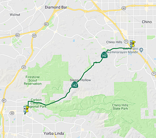 From Route 90 near Brea to Route 71 near Chino.
 Post 1964 Signage History
As defined in 1963, this segment was "(a) Route 42 near Brea to Route 71 near Chino."
In 1972, Chapter 1216 changed "Route 42" to "Route 90".
Route 142 was realigned to a new terminus at Route 90 directly via
Valencia Avenue on the 1982 State Highway Map. The alignment was
likely constructed during 1981.
(Source: Gribblenation Blog (Tom Fearer), "California State Route 142", 1/2023)
 Pre 1964 Signage History
This segment was originally LRN 177, defined in 1933. It was not signed
before 1964. It originally split off or Route 90 [LRN 176] at Carolina
(now Kraemer), then Olinda Boulevard (new Birch) to Valencia Ave, and then
up to Carbon Canyon Rd. It crossed into San Bernardino County, and
terminated at Route 71/LRN 77 at Pipeline Avenue via Merrill Avenue (now
Chino Hills Parkway) south of Chino.
(Some details from: Gribblenation Blog (Tom Fearer), "California State Route 142", 1/2023)
 Status
In August 2011, the CTC approved $3,025,000 in SHOPP funding for repairs in and near Brea, from Brea Hills Ave to the San Bernardino County Line (~ ORA 2.515 to ORA 6.346), that will rehabilitate 7.6 lane miles of pavement to improve safety and ride quality.
Carbon Canyon Truck Restrictions (~ORA R1.801 to SBD R3.792)
In May 2017, it was reported that Caltrans is exploring
a plan to restrict truck traffic on this route. The first step to restrict
big rigs on Carbon Canyon Road (~ORA R1.801 to SBD R3.792) took place in
early May when a preliminary study on the state highway was unveiled to
approximately 50 residents at the Chino Hills public works commission
meeting. Transportation engineering consultant Clyde Prem said trucks are
scraping the roadside and causing ten-to-twenty minute traffic delays
navigating the switchbacks and steep grades. He said a process exists
where Caltrans can restrict truck traffic but it is rarely undertaken. It
includes sending resolutions to two Caltrans districts because the
8.4-mile road, known as Route 142, is located in Brea and Chino Hills.
Traffic, legal, and environmental offices in Sacramento would become
involved in the effort. The study was commissioned last November after
concerns mounted about the volume of traffic on Carbon Canyon Road and the
increased amount of large trucks using the road as a bypass route. Traffic
congestion is also caused by the terrain, school bus stops, uphill grades,
a narrow bridge, and the signals at Olinda Place and Ruby Street on the
Brea side, according to the study. The report revealed 92 collisions
resulted in 153 injuries and three fatalities between 2010 and 2015. Of
the injuries, 52 were in Chino Hills and 101 in Brea. Unsafe speed and
improper turning were the two leading causes of collisions. Residents said
trucks cross the yellow lines on the switchbacks endangering oncoming
traffic. Caltrans has determined that widening is not possible because of
the terrain and development alongside the road. The commission voted to
support the second phase of the study that would address truck traffic,
safety, and traffic flow along Carbon Canyon Road.
(Source: Champion Newspapers, 5/6/2017)
In June 2019, it was reported that Chino Hills and Brea
have each adopted resolutions requesting Caltrans to ban large truck
traffic from using Carbon Canyon Road. The cities submitted the
resolutions to Caltrans June 19. The city has been working for the last
few years with Caltrans, the Chino Hills and Brea police departments, the
City of Brea, and the California Highway Patrol to study the problem. It
was agreed that a traffic study was needed to identify key issues and
propose solutions with an emphasis on banning large-truck traffic.
Residents have been expressing concern that excessively large trucks
cannot maneuver through the tight curves along Carbon Canyon Road and
encroach onto oncoming traffic as they make the turns. Chino Hills and
Brea shared costs for the traffic study.
(Source: Champion Newspapers, 6/29/2019)
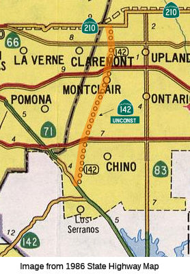
 From Route 71 near Chino to Route 210 near Upland.
Post 1964 Signage HistoryAs defined in 1963, this segment was "(b) Route 71 near Chino to Route 30 near Upland."
In 1999, this segment was changed to end at Route 210, reflecting the 1998 change of Route 30 to Route 210 (AB 1650, Ch 724, 10/10/99).
Pre 1964 Signage HistoryThis segment is proposed LRN 274, defined in 1959. Its routing has not been determined, and it does not appear to correspond to a surface street route.
Status Central Avenue and a grid of local streets could be used but the roads do not adequately fit the definition of a traversable highway. A
route is in the very preliminary planning stages.
The 2013 Traversable Highways report notes there have been preliminary discussions with local transportation agencies which may lead to planning studies. Central Avenue and a grid of urban streets could be used but the roads do not adequately fit the description of a traversable highway.
 Naming
"Carbon Canyon Freeway". Named by location.
Pre 1964 Signage HistorySign Route 142 was not defined as part of the initial state signage of routes in 1934. It is unclear what (if any) route was signed as Route 142 between 1934 and 1964.
 Scenic Route
[SHC 263.7] From the Orange-San Bernardino county line to Peyton Drive.
 Freeway
[SHC 253.7] From Route 71 near Chino to Route 210 near Upland. (Change from Route 30 to Route 210 by AB 1650, Ch. 724, 10/10/99). Added to the Freeway and Expressway system in 1959.
 Other WWW Links
 Statistics
Overall statistics for Route 142:
 Pre-1964 Legislative Route
In 1933, Chapter 767 defined the route from "[LRN 4] near Bakersfield to [LRN 57] near Isabella via Glennville" as part of the state highway system. In 1935, this route was added to the code as LRN 142 with that definition. In 1963, Chapter 1698 would have changed LRN 4 to LRN 141, but that change didn't occur due to the passage of the "great renumbering" (Chapter 385).
This route originally was the Bakersfield-Glennville Road into Glennville and thence to Isabella via Woody. All of this was originally part of Route 155. However, in 1965, the Bakersfield to Glennville Road portion was deleted from the state highway system and Route 155 was rerouted onto former LRN 136 (part of former Route 211).
© 1996-2020 Daniel P. Faigin.
Maintained by: Daniel P. Faigin
<webmaster@cahighways.org>.
 Route 141
 Route 143