
State Route 189
Click here for a key to the symbols used. An explanation of acronyms may be found at the bottom of the page.
 Routing
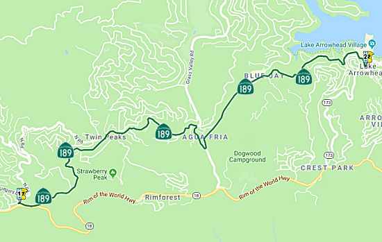 From Route 18 near Strawberry Peak to Route 173 near Lake Arrowhead via Strawberry
Flat.
From Route 18 near Strawberry Peak to Route 173 near Lake Arrowhead via Strawberry
Flat.
 Post 1964 Signage History
This route is as defined in 1963 (hell, 1933!)
 Pre 1964 Signage History
The current route has the same number as the pre-1963 LRN. LRN 189 was
defined in 1933. However, Route 189 was not included in the initial set of
state signed routes in 1934.
 Other WWW Links
 Statistics
Overall statistics for Route 189:
- Total Length (1995): 6 miles
- Average Daily Traffic (1992): 3,200 to 7,500
- Mileage Classification: Rural: 0; Sm. Urban: 6; Urbanized: 0.
- Previous Federal Aid Mileage: FAU: 6 mi.
- Functional Classification: Minor Arterial: 6 mi.
- Counties Traversed: San Bernardino.
 Pre-1964 Legislative Route
In 1933, the route from "[LRN 43] near Strawberry Peak via Strawberry
Flat to the Cajon Pass-Lake Arrowhead Road near Lake Arrowhead" was added
to the state highway system. In 1935, this was added to the highway code
as LRN 189 with the routing:
"[LRN 43] near Strawberry Peak via Strawberry Flat to [LRN 59] near
Lake Arrowhead"
This definition remained the same until 1963, and modulo route number
changes, is still the routing for Route 189.
Acronyms and Explanations:
- "LRN" refers to the Pre-1964 Legislative Route Number.
"US" refers to a US Shield signed route.
"I" refers to an Eisenhower Interstate signed route.
"Route" usually indicates a state shield signed route, but said route may be signed as US or I.
- Previous Federal Aid (pre-1992) categories:
Federal Aid Interstate (FAI); Federal Aid Primary (FAP);
Federal Aid Urban (FAU); and Federal Aid Secondary (FAS).
Current Functional Classifications (used for aid purposes):
Principal Arterial (PA); Minor Arterial (MA);
Collector (Col); Rural Minor Collector/Local Road (RMC/LR). Note that ISTEA repealed the previous Federal-Aid System, effective in 1992, and established the functional classification system for all public roads.
- Other frequently used terms: California Transportation Commission (Commission or CTC), California Department of Transportation (Department or Caltrans), Regional Improvement Program (RIP), Interregional Improvement Program (IIP), State Transportation Improvement Program (STIP), State Highway Operation and Protection Program (SHOPP), Traffic Congestion Relief Program (TCRP), Clean Air and Transportation Improvement Act of 1990 (Proposition 116), High Speed Passenger Train Bond Program (Proposition 1A), Highway Safety, Traffic Reduction, Air Quality, and Port Security Bond Act of 2006 (Proposition 1B), Corridor Mobility Improvement Account (CMIA), State Route 99 Bond Program (RTE or SR 99), Local Bridge Seismic Retrofit Account (LBSRA), Trade Corridors Improvement Fund (TCIF), Highway-Railroad Crossing Safety Account (HRCSA), State-Local Partnership Program (SLPP), Environmental Phase (PA&ED), Design Phase (PS&E), Right of Way (R/W), Fiscal Year (FY), Active Transportation Program (ATP), Trade Corridor Enhancement Program (TCEP), Local Partnership Program (LPP), Local Streets and Roads Program (LSRP), Solutions for Congested Corridors Program (SCCP).
 Route 188
 Route 190
© 1996-2020 Daniel P. Faigin.
Maintained by: Daniel P. Faigin
<webmaster@cahighways.org>.

 California Highways: