
 California Highways:
Click here for a key to the symbols used. An explanation of acronyms may be found at the bottom of the page.
 Routing
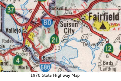 No current routing.
 Post 1964 Signage History
 In 1963, Route 21 was defined to run "from Route 680 at Benecia to
Route 80 near Cordelia". In 1976, this routing was transferred to I-680 by
Chapter 1354 as part of the creation of I-780 (which used to be part of
I-680).
Route 21 was the former surface street routing that became the new I-680. Part of Route 21 used Pacheco Boulevard, Contra Costa Boulevard in the Concord/Pleasant Hill area and Main Street in Walnut Creek. The next street south is Danville Boulevard, through Walnut Creek, Alamo and Danville; it becomes Hartz Avenue in Danville before becoming San Ramon Valley Boulevard. Other former routings include San Ramon Valley Boulevard between Danville and Dublin, San Ramon Road in Dublin, and Foothill Road from I-580 south to Sunol. For a while, Route 21 and I-680 were cosigned.
 Pre 1964 Signage History
 Route 21 was not signed as part of the initial state route signage
in 1934.
Route 21 was not signed as part of the initial state route signage
in 1934.
 Route 21 (when first
signed around 1935) started in Warm Springs. Tom Fearer traced the
original routing NB from Route 17 at Warm Springs Road:
Route 21 (when first
signed around 1935) started in Warm Springs. Tom Fearer traced the
original routing NB from Route 17 at Warm Springs Road:
(Source: Gribblenation Blog Interstate 680 over the Benicia-Martinez Bridge and the legacy of California State Route 21)
In the mid-1950s, Route 17 was moved to a new routing (what is now the I-880 routing). Route 21 was extended at that time to meet the new Nimitz Freeeway from Warm Springs Road along an extension of Mission Blvd to Warren Ave.
Route 21 diverged from Route 9 near Mission San Jose, and ran to Route 84 near Sonol. This segment was LRN 108, defined in the 1933 definition of secondary routes. The signage for Route 21 first appeared in October 1935; CHPW reported that signed Route 21 had been added, running from Mission San Jose to Walnut Creek via Sunol and Dublin. In understanding this routing, now that before 1964, what is now I-680 was Route 21.
From Sonol, Route 21 continued NE through San Ramon, Danville and
Alamo to Route 24 near Walnut Creek. This segment was LRN 107, also
defined in 1933.
From what is now Route 24 in Walnut Creek, it continued to Benecia
along a routing similar to the current I-680. This was part of LRN 75. The
portion between Route 24 and Route 242 was defined in 1933. It was
extended N to Martinez in 1949, and to Benecia in 1953. The routing was
moved from the ferry to the bridge in 1957.
From Benecia, signed Route 21 continued to US 40 (LRN 7; now I-80)
along a NE alignment. This routing was originally part of LRN 7,
authorized by the first bond act. The routing was later considered part of
LRN 74, and is the current I-680 routing. Note that LRN 75 also continued
to US 40 (now I-80), along the current I-780 routing.
There are sections of Route 680 that veer from the old alignment
when you get into towns such as Walnut Creek, etc. Before the completion
of the Benecia-Martinez Bridge, the Route 21 alignment used Pacheco Blvd
to get into Martinez, and then a ferry to Benicia. Route 21 ended at the
intersection of the old Mission Grade Road and Mission Blvd.
 It appears that some sections of this route were part of Route 40.
According to Chris Sampang, US 40 followed the Goodyear Road southwest of
Fairfield, California, crossing the Sacramento River at Benicia. This is
part of what was Route 21.
It appears that some sections of this route were part of Route 40.
According to Chris Sampang, US 40 followed the Goodyear Road southwest of
Fairfield, California, crossing the Sacramento River at Benicia. This is
part of what was Route 21.
According to Tom Fearer on Gribblenation: By 1915 a steam ferry known as
the City of Seattle was the first to carry automotive traffic across the
Carquinez Straights. Access to the Martinez-Benicia Ferry was by way of
LRN 14 and LRN 7. LRN 14 was routed into Martinez via what is now
Carquinez Scenic Drive east of Crockett. Carquinez Scenic Drive as a State
Highway was completed by 1912. LRN 7 entered Benicia via 2nd Street. LRN 14 and LRN 7 can be seen meeting at the Carquinez Straights at the
Martinez-Benicia Ferry on the 1918 Division of Highways Map. In late 1926
the US Route System was created. The initial routing of US 40 was aligned
over LRN 7 into Benicia, over the Martinez-Benicia Ferry and LRN 14
towards Oakland. US 40 can be seen aligned over the Martinez-Benicia Ferry
on the 1930 Automobile Club of Southern California. The primary driver of
US 40 being routed away from Benicia and Martinez was the completion of
the original Carquinez Bridge in 1927. The Carquinez Bridge originally
carried the final alignment of the Lincoln Highway when it opened as a
private toll bridge. In 1929 the Martinez-Benicia Ferry was acquired by
the American Toll Bridge Company which also operated the Carquinez Bridge.
In 1931, a spur route of LRN 7 was adopted from LRN 14 in Crockett through
the American Canyon Route. US 40 was reported rerouted through Vallejo via
the Carquinez Bridge and the American Canyon Route on the 8th Biannual
Report by the Division of Highways in November 1932. The Martinez-Benicia
Ferry remained in operation after US 40 was moved to the Carquinez Bridge
and became part of Route 21, which occurred likely by 1935. In 1940 the
legislature approved for Department of Public Works to formally request
that control of the Martinez-Benicia Ferry be transferred by the American
Toll Bridge company to the cities of Martinez and Benicia. The
Martinez-Benicia Ferry was transferred to the City of Martinez on January
1st of 1941. LRN 14 west of Martinez on Carquinez Scenic Drive remained
part of the State Highway System as an unsigned highway until 1953. In
1953 LRN 14 was truncated from Martinez to Crockett. 1953 was also saw the
definition of LRN 75 changed to include the Martinez-Benicia Ferry under
state ownership. Route 21 continued to utilize the Martinez-Benicia Ferry
until September 15, 1962 when it was replaced by highway bridge which now
carries the southbound lanes of I-680.
(Source: Gribblenation Blog "The original alignment of US Route 40 over the Martinez-Benicia Ferry and Carquinez Scenic Drive")
The Gribblenation Blog (Tom Fearer) Interstate 680 over the Benicia-Martinez Bridge and the legacy of California State Route 21, 2/22/2019, has a detailed summary of the specific routings and history of Route 21.
 In January 1955, the California Highway Commission adopted a freeway routing for then
Route 21 (future I-680) between Danville and Walnut Creek. The route runs
along the E side of San Ramon Creek and generally parallels the existing
Route 21 about 1,000 to 2,000 ft. to the E. Beginning 1 mi. S of Danville,
it bypasses that community to the E and extends to Circle Drive in Walnut
Creek, a distance of approx. 6½ mi.
In January 1955, the California Highway Commission adopted a freeway routing for then
Route 21 (future I-680) between Danville and Walnut Creek. The route runs
along the E side of San Ramon Creek and generally parallels the existing
Route 21 about 1,000 to 2,000 ft. to the E. Beginning 1 mi. S of Danville,
it bypasses that community to the E and extends to Circle Drive in Walnut
Creek, a distance of approx. 6½ mi.
(Source: Contra Costa Gazette, 1/27/1955 and Oakland Tribune,
1/27/1955 via Joel Windmiller, 1/27/2023)
 Other WWW Links
 Pre-1964 Legislative Route
The history of LRN 21 is closely tied to the history of LRN 30.
In 1909, the routing that would become LRN 21 was defined in the First Bond Act as running "from [LRN 3] near Richvale to Oroville." At the same time, the First Bond Act authorized a route from Oroville to Quincy (this was to become LRN 30). In 1919, the Third Bond Act extended the future LRN 21 to Quincy, and (at least within the Highway Commission, for it wasn't defined legislatively) LRN 30 was transferred to LRN 21. In 1931, Chapter 82 extended LRN 21 to "[LRN 29] near Chats via Quincy and Beckwourth Pass." (Chats is a former town near the Nevada State Line, near the area now called Hallelujah Junction). By 1935, LRN 21 was codified into the highway code as the following two segments:
The portion from [LRN 3] near Richvale to Quincy via Oroville was considered a primary route.
In 1957, Chapter 36 changed the definition to combine the two segments, making it "from [LRN 3] near Richvale to [LRN 29] near Chats via Quincy and the Beckworth Pass" (note the change in routing).
This routing started at US 99 (LRN 3) and ran to Oroville. The pre-1964 signage is unclear, but it is presently Route 162. From Oroville, it ran signed as Alt US 40 (now Route 70) to junction with US 395 (LRN 29) near Hallelujah Junction.
Other WWW Links© 1996-2020 Daniel P. Faigin.
Maintained by: Daniel P. Faigin
<webmaster@cahighways.org>.
 Route 20
 Route 22