
 California Highways:
Click here for a key to the symbols used. An explanation of acronyms may be found at the bottom of the page.
 Routing
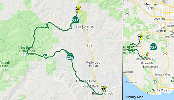 From Route 9
near Boulder Creek to Route 9 near Waterman Gap via Governor's Camp in Big
Basin Redwoods State Park.
From Route 9
near Boulder Creek to Route 9 near Waterman Gap via Governor's Camp in Big
Basin Redwoods State Park.
 Post 1964 Signage History
In 1963, this route was defined as “Route 9 near Boulder Creek to Route 9 near Waterman Gap via Governor's Camp in Big Basin Redwood State Park.”
In 1990, Chapter 1187 clarified the origin: “Route 9 near
in Boulder Creek to …”
 Pre 1964 Signage History
This was LRN 44 (defined in 1917) between Route 9 near Boulder Creek and Big Basin, and LRN 42 (defined in 1913) between Big Basin and Route 9 near Waterman Gap. Until some point as early as 1940, but possibly as late as 1951, this was signed as part of Route 9 (one of the original 1934 signed routes). By 1951, Route 9 was realigned off LRN 42 and LRN 41 to LRN 116.
Access to Big Basin began in 1913 when the Legislative Chapter 398
approved LRN 42. Access to Big Basin was enhanced in 1917 when Legislative
Chapter 703 created LRN 44. The routes of what would become Big Basin
Highway via LRN 42 and LRN 44 can be seen passing through California
Redwoods State Park on the 1917 California State Automobile Association
Map. LRN 42 and LRN 44 were developed off of preexisting logging
roads. The concrete arch bridges over Boulder Creek on what was LRN 44
were completed by 1921. The completion of LRN 44 is noted on the
1922 Division of Highways State Map, which shows the entire Big Basin
Highway under state maintenance. Route 9 appears on LRN 44 and LRN 42
through Big Basin Redwoods State Park on the 1935 Goshua Highway Map of
California, but by the 1940 Rand McNally map, it is shown along LRN 116.
By the 1951 issue of CHPW, Route 9 is being shown along LRN 116 in state
discussions.
(Source: Gribblenation Blog (Tom Fearer): Disaster Tourism Road Trip Park 2; California State Route 236 and Big Basin Redwoods State Park, August 2020)
 Status
In March 2021, it was reported that the CTC approved a $5 million
allocation to build a tieback wall, restore the roadway, improve drainage
facilities, and install permanent erosion control measures on Route 236
near Boulder Creek (~ SCR 1.635) in Santa Cruz County.
(Source: Paso Robles Daily News, 3/26/2021)
In July 2022, it was reported that Route 236 — the main roadway through the Big Basin Redwoods State Park — was open to drivers once again as state park officials make forward progress in restoring the forest after the 2020 CZU Lightning Complex Fire. The road closure from Little Basin Road (SCR 6.418), 6.4 miles north of the southern junction of Route 9, to China Grade (SCR 4.129), 4.8 miles south of the northern junction of Route 9, was lifted in late July 2022. Drivers can roll through Big Basin without stopping, or park with a reservation. The park is open on a limited day-use-only reservation system as the forest continues to recover from the effects of the fire from two years ago. Park officials say that 18,000 acres of park property were burned, including the park headquarters, campgrounds and housing for park employees.
 Scenic Route
[SHC 263.1] Entire route.
 Other WWW Links
 Statistics
Overall statistics for Route 236:
 Pre-1964 Legislative Route
In 1955, Chapter 1789 defined LRN 236 as “…a point northwest of the City of Santa Barbara on [LRN 2] to the campus of the University of California at Santa Barbara, Goleta Campus. The commission shall allocate from the State Highway Fund the necessary funds for the construction of said route. The allocation of money provided for in this section shall be made out of moneys contained in the State Highway Fund available for construction of state highways in County Group No. 2, but which is not subject to Section 188.4; and expenditures from such allocation shall be credited against the expenditures required to be made pursuant to Section 188.4 in Santa Barbara County until June 30, 1963. This route shall be a memorial to the late Senator Clarence C. Ward of Santa Barbara County and shall hereafter be known as Clarence Ward Memorial Boulevard.”
This is present-day Route 217.
© 1996-2020 Daniel P. Faigin.
Maintained by: Daniel P. Faigin
<webmaster@cahighways.org>.
 Route 235
 Route 237