
 California Highways:
Click here for a key to the symbols used. An explanation of acronyms may be found at the bottom of the page.
 Routing
 Post 1964 Signage History
This routing is unchanged from its 1963 definition.
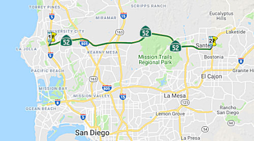
Route 52 was established as part of the California Freeway and Expressway System in 1959 (former LRN 279). The portion of Route 52 from I-5 to I-805 was adopted in 1962 and opened to traffic in 1970. This stretch was known as the Soledad Freeway.
The portion from I-805 to I-15 was adopted in July 1972 and opened to
traffic in 1988. This included stretches of Route 52 in the Kearny Mesa
area. These segments, which stretched about 5 miles east from I-805
to Santo Road and cost about $33 million, were built in part over portions
of the Miramar Landfill that had closed 14 years earlier. Before too long,
the roadway started sinking in various places, creating a roller coaster
ride of dips and undulations that made driving it an adventure.
Maintenance crews went out and put down an overlay of asphalt, smoothing
the roadway. Then parts of it sank as the ground underneath shifted again.
That meant more asphalt. This has gone on every few years, costing
taxpayers millions of dollars in repairs. At the time of construction,
this segment (from I-805 to Convoy) was viewed as a "sweetheart to build"
as the wide-open spaces it went through — with no structures or
trees to work around — allowed it to be finished in about 18 months.
It took another year to continue the highway to Santo Road. Caltrans
engineers in 2020 suspect the engineers in the 1980s did not anticipate
the severity of the roadway sinking caused by the biodegradation, creep
and consolidation of the landfill materials, or the frequency of the
asphalt overlays that would be required over the years to flatten it out.
The old dump in Kearny Mesa was known as the South Miramar Landfill. It started in 1959, after city officials leased 192 acres from the military on the southern end of what
is now Marine Corps Air Station Miramar. Used mostly for residential
trash, the landfill was closed in 1973 and the city moved to new locations
nearby, first north and then west, where the operations continue.
(Source: San Diego Union Tribune, 10/3/2020)
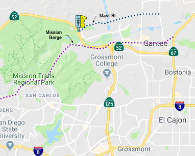
In July 1989, the California Transportation Commission (CTC) adopted the plan for the then unconstructed segments of Route 52 from I-15 to Route 67. The segment I-15 to Mast Boulevard opened for traffic in December 1993, and Mast Boulevard to Route 125 opened in November 1998.
The portion of Route 52 from Route 125 to Route 67 was completed in Spring of 2011.
 Pre 1964 Signage History
This routing was unconstructed in 1963, although the routing had been determined. It was LRN 279, defined in 1959.
 Route 52 was not defined as part of the initial state signage of
routes in 1934. It is unclear what (if any) route was signed as Route 52
between 1934 and 1964.
Route 52 was not defined as part of the initial state signage of
routes in 1934. It is unclear what (if any) route was signed as Route 52
between 1934 and 1964.
 Status
By 1996, the freeway was complete from Route 5 to Mast Blvd and Mission Gorge Road in Santee (~ SD 0.000 to SD 13.285) . An extension between Mission Gorge Road and Route 125 in Santee is under construction, and should have been completed by Winter 1997 (to ~ SD 14.887).
In March 2019, the CTC approved the following allocation: $3,002,000 San
Diego 11-SD-52 0.4/14.8 PPNO 11-1135. Proj ID 1115000026. Route 52 In the
city of San Diego and Santee, from 0.4 mile east of Route 5 to Route 125.
Outcome/Output: Construct rumble strips, construct concrete barrier, and
upgrade guardrail and end treatments. This project will improve safety by
reducing the frequency and severity of collisions from vehicles leaving
the traveled way.
(Source: March 2019 CTC Minutes, Agenda Item
2.5b.(4) Project 4)
In March 2013, the CTC authorized $3,937,000 to overlay 7.2 lane miles of pavement to mitigate settlement and to improve safety and ride quality on a segment in the city of San Diego, from 0.5 mile west of Convoy Street to 0.4 mile west of Route 163/Route 52 separation (~ SD 4.963 to SD 6.18).
Convoy to Santo Auxiliary Lane (SD-52 5.1/8.7)
In August 2018, the CTC amended the following project
into the 2018 SHOPP: 11-SD-52 5.1/8.7. PPNO 1302. Project 1118000079. EA
43025. Route 52 In San Diego, from 0.4 mile west of Convoy Street
Overcrossing to Santo Road Overcrossing. Roadway rehabilitation to
mitigate highway settlement, construct auxiliary lane, transportation
management systems, lighting, and roadside safety improvements. Est. cost:
$44,970,000. Est. const. start: 7/29/2022.
(Source: August 2018 CTC Agenda Item 2.1a.(1))
The 2020 SHOPP, approved in May 2020, included the
following Roadway Rehabilitation item of interest (carried over from the
2018 SHOPP): 11-San Diego-52 PM 5.1/8.7 PPNO 1302 Proj ID 1118000079 EA
43025. Route 52 in San Diego, from 0.4 mile west of Convoy Street
Overcrossing (OC) to Santo Road OC. Roadway rehabilitation to mitigate
highway settlement, construct auxiliary lane, Transportation
Management System (TMS), lighting, and roadside safety improvements.
Programmed in FY21-22, with construction scheduled to start at the end of
July 2022. *Construction capital and construction support phases
are NOT authorized Total project cost is $44,970K, with
$33,753K being capital (const and right of way) and $11,217K being support
(engineering, environmental, etc.).
(Source: 2020 Approved SHOPP a/o May 2020)
It was reported in October 2020 that Caltrans was
trying a different approach to the settlement along this segment. Crews
are drilling thousands of holes in the pavement, through all those layers
of asphalt, and injecting columns of grout — a mixture of sand,
water and cement — that they hope will compact the underlying soil,
fill in cavities and entomb some of the decomposing and ever-shifting
trash. Caltrans experimented with that approach on a small section of the
freeway in 2016, and it firmed up the subgrade and limited the
instability. Since late August 2020, Caltrans has been working in the area
between I-805 and Route 163, sometimes seven nights a week, flattening the
roadway and strengthening nearby culverts. The $16.5 million project is
scheduled to be finished in November 2020.
(Source: San Diego Union Tribune, 10/3/2020)
In October 2020, the CTC received a report of the
following Emergency (G-11, (1)), SHOPP Safety (3), or Minor G-05-16 (4)
allocation: $18,000,000 ($1,500,000 Con Eng; $16,500,00 Const) for
11-SD-52 PM 5.1/6.2 PPNO 11-1415 ProjID 1120000103 EA 43112. In the city
of San Diego, from 0.4 mile west to 0.7 mile east of Convoy Street.
Storms during the week of March 30, 2020 have contributed to the
accelerated settlement of Route 52 within the project limits. This
road segment was constructed over a landfill in 1959, and the highway
segment has continued to settle beyond the projected consolidation
period. Eleven projects over the past 11 years have failed to
permanently address settlement issues, with individual dips reaching eight
inches or more. Project EA 43025/PPNO 11-1302 is scheduled for
construction in Fall 2022 to repair the location, but the condition is so
severe that waiting is not a viable option. On July 1, 2020, message signs
were deployed to warn the public of the road conditions. This
project will stabilize the roadway by a combination of compaction
grouting, geogrid stilization, and repaving with Continuously Reinforced
Concrete Pavement (CRCP).
(Source: October 2020 CTC Agenda, Agenda Item
2.5f.(1) #19)
In October 2022, it was reported that the CTC, at its
October 2022 meeting, allocated $56 million to construct an auxiliary
lane, mitigate highway settlement, install lighting, and other roadside
safety improvements on Route 52 between Convoy Street and Santo Road. The
allocation includes $49.6 million in jobs act funds.
(Source: Times of San Diego, 10/16/2022)
In October 2022, the CTC approved the following
construction phase allocation: $55,999,000. 11-SD-52 5.1/9.0. PPNO
11-1302; ProjID 1118000079; EA 43025. Route 52 In the city of San Diego,
from 0.4 mile west of Convoy Street to 0.3 mile east of Santo Road. Outcome/Output:
Rehabilitate roadway to mitigate highway settlement, construct auxiliary
lane, Transportation Management System (TMS), lighting, and roadside
safety improvements. This project will preserve and extend the life
of the facility, improve ride quality, and improve safety. Programmed
allocation: CON ENG $7,800,000; CONST $45,592,000. CEQA - CE, 2/2/2021;
Re-validation 6/23/2022. NEPA - CE, 2/2/2021; Re-validation 6/23/2022.
Four month time extension for CONST and CON ENG approved under Waiver
22-73; June 2022. Concurrent Amendment under SHOPP Amendment 22H-004;
October 2022. SB 1 Baseline Agreement approval under Resolution
SHOPP-P-2021-06B; May 2021.
(Source: October 2022 CTC Agenda, Agenda Item
2.5b.(1) #28)
In May 2023, the CTC approved the following additional
PS&E allocation for this project: $200,000. 11-SD-52 5.1/9. PPNO
11-1302; ProjID 1118000079; EA 43025. Route 52 In the city of San Diego,
from 0.4 mile west of Convoy Street Overcrossing (OC) to 0.3 mile east of
Santo Road. Rehabilitate roadway to mitigate highway settlement, construct
auxiliary lane, Transportation Management System (TMS), lighting, and
roadside safety improvements. Outcome/Output: This project will preserve
and extend the life of the facility, improve ride quality, and improve
safety. CEQA - CE, 2/2/2021; Re-validation 6/23/2022 NEPA - CE, 2/2/2021;
Re-validation 6/23/2022. The project realized cost increases during
PS&E due to the Department’s decision to re-advertise the
contract based on the results of the bid opening in December 2022.
The bids were analyzed and rejected as they had come in significantly
higher than the Engineer’s Estimate. The Department decided to
modify the contract to address issues raised by the bidders. The
Department had anticipated to repackage the contract to account for the
changes needed to address the bidders’ issues that included
modifications to the compaction grouting work and increased unit cost for
jointed plain concrete pavement. Materials for transportation
management system elements and fiber optic cable system have also
increased due to supply issues. To re-advertise the project and meet
the Department’s policy, the contract was modified to incorporate
the 2022 Construction Contract standards and revise the Buy America
requirements. As a result, the project required more resources than
what was originally allocated due to these changes. The remaining work and
resource needs were analyzed, and completion of PS&E is expected by
November 2023. Therefore, the project requires an additional
$200,000 to complete the PS&E phase.
(Source: May 2023 CTC Agenda, Agenda Item 2.5e.(8))
Additionally, in May 2023, the CTC approved the
following additional construction capital allocation for this project:
$7,106,000. 11-SD-52 5.1/9. PPNO 11-1302; ProjID 1118000079; EA 43025.
Route 52 In the city of San Diego, from 0.4 mile west of Convoy Street
Overcrossing (OC) to 0.3 mile east of Santo Road. Rehabilitate roadway to
mitigate highway settlement, construct auxiliary lane, Transportation
Management System (TMS), lighting, and roadside safety improvements.
Outcome/Output: This project will preserve and extend the life of the
facility, improve ride quality, and improve safety. CEQA - CE, 2/2/2021;
Re-validation 6/23/2022 NEPA - CE, 2/2/2021; Re-validation 6/23/2022.The
project realized cost increases due to the results of the bid opening
which included higher material prices for the asphalt items, jointed plain
concrete pavement, fiber optic cable systems, and compaction
grouting. In addition, there were higher unit prices for traffic
control items, storm water pollution control items, and earthwork items;
the remaining bid item prices were very close to the EE. In December
2022, the Department evaluated the bids and found no evidence of
mathematical or material unbalancing. The three bids ranged from
49.9 to 77.7 percent over the EE. Since the low bid was
significantly higher than the EE, the Department decided to reject the bid
and re-advertise the project. In January 2023, the Department
re-evaluated the project plans, specifications, and estimate and realized
that changes could result in more clarity for the bidders, and better
alignment between the bids and the current estimate. One of the major
changes made by the Department was to incorporate a new standard special
provision for compaction grouting which added a new bid item. Since the
last certification of the EE was in August 2022, a new EE was needed that
incorporated these changes. The original EE was updated and
recertified in March 2023, incorporating a significant rise in prices for
labor, material, and supplies. The new EE better reflects the
current trend of market prices for traffic control, concrete pavement,
landscape, and electrical items. In aggregate, these items amount to an
increase of $4,433,000 over the allocated amount. The remaining
increase is due to an increase in contingency from five to ten percent and
minor unit price increases of other bid items.
(Source: May 2023 CTC Agenda, Agenda Item 2.5e.(9))
In December 2023, the CTC considered a request for
supplemental fundings of an additional $9,656,000 (17.7 percent increase)
in Construction Capital for11-SD-52 5.1/9; PPNO 11-1302; ProjID
1118000079; EA 43025. Route 52 In the city of San Diego, from 0.4 mile
west of Convoy Street Overcrossing (OC) to 0.3 mile east of Santo
Road. Rehabilitate roadway to mitigate highway settlement, construct
auxiliary lane, Transportation Management System (TMS), lighting, and
roadside safety improvements. Outcome/Output: This project will preserve
and extend the life of the facility, improve ride quality, and improve
safety. Supplemental funds are needed to Award. CEQA - CE, 2/2/2021;
Re-validation 6/23/2022 NEPA - CE, 2/2/2021; Re-validation 6/23/2022 Total
revised amount $64,356,000. Bids were opened in December 2022, of which
the Department received three bids. Since the bids were much higher
than the project allocation and available G-12 funds, the Department
decided to reject the bids, amend the contract package, and re-advertise
the project to account for the higher material prices and incorporate a
new standard special provision for compact grouting. In May 2023,
the Department re-advertised the contract and held bid opening in
September 2023. The contract received one bid, which is 19.1 percent
above the Engineer’s Estimate (EE). The cost increases on this
project are largely attributed to the compact grouting, traffic control,
roadway excavation, storm water pollution prevention items, and vegetation
control mat. Although the EE was adjusted to incorporate changes
from the first advertisement, the bid submitted was higher than the EE on
a few bid items. The work required for the compact grouting is
unique in nature with limited bid data and a lot of risk that is difficult
to estimate. The EE did consider the amount of risk the contractor
would bear and utilized lessons learned resulting in a lower bid than the
first advertisement, however, the current bid still came in higher.
The assumptions utilized in the EE factored in means and methods for
traffic control and closures, storm water pollution prevention items,
material handling, and vegetation control mat. The bidder cited more
traffic closures than anticipated in the EE. The storm water pollution
prevention items are also affected by the assumed risks. In
addition, the compaction grouting and traffic control efforts increased
due to more washouts being required as more grouting and staging is
needed. The bidder also factored the double handling of the roadway
excavation material into their unit prices. Additionally, the bidder
anticipates the need for extensive daily sweeping efforts.
(Source: December 2023 CTC Agenda, Agenda Item 2.5e.(16))
In August 2016, the CTC authorized relinquishment of right of way in the city of San Diego (City) along Route 52 at Kearny Villa Road (11-SD-52-PM 6.9), consisting of collateral facilities. The City, by freeway agreement dated April 8, 1986, agreed to accept title upon relinquishment by the State. The 90-day notice period expires July 17, 2016. A portion of the original routing has been relinquished: between PM 12.6 and PM 13.1, per the March 2001 CTC Agenda.
In February 2008, the CTC relinquished a portion of the route in San Diego, at Sycamore Landfill Road northerly of Mast Boulevard (~ SD 12.871), consisting of relocated and reconstructed city streets and frontage roads.
Route 52 Coalition
 In July 2018, it was reported
that the Santee City Council had been granted the authority to create a
State Route 52 Coalition to fast-track needed changes to the route. The
coalition will be a partnership between local and regional entities
interested in immediate improvements to the highway. Members could include
representatives from the region’s planning agency, the San Diego
Association of Governments (SANDAG), San Diego County, the cities of San
Diego, El Cajon, La Mesa, Lemon Grove, Chula Vista, the local and regional
business community, and environmental groups such as Preserve Wild Santee.
The stakeholders would fund efforts to highlight the need for immediate
action on Route 52, working with decision-makers to influence the process
and seek funding. Santee will be the clearinghouse for the process. The
City Council says Santee commuters impacted by the route by being forced
to sit on Mast Boulevard (SD 13.28) and Mission Gorge Road (SD 14.833)
waiting for their turn to get onto Route 52 in the morning, then are
stalled on the freeway waiting to exit during the evening commute. The
year the freeway opened in 2011, there were an average of 70,000 daily
trips taken as recorded at Mast Boulevard, according to statistics from
the California Department of Transportation, That number jumped to 83,000
in 2016, Caltrans said. SANDAG’s 2035 vision includes widening Route 52 from two lanes each way to three lanes in each direction from Route 125
to I-805. The plan is said to include installing two reversible managed
lanes for high occupancy use and single-occupancy use with a fee (similar
to the ones on I-15) from Route 125 to I-805. But Santee, which has grown
from 40,000 residents when it incorporated in 1980 to 53,000 as of the
2010 census and is growing exponentially says it can’t wait 17 more
years.
In July 2018, it was reported
that the Santee City Council had been granted the authority to create a
State Route 52 Coalition to fast-track needed changes to the route. The
coalition will be a partnership between local and regional entities
interested in immediate improvements to the highway. Members could include
representatives from the region’s planning agency, the San Diego
Association of Governments (SANDAG), San Diego County, the cities of San
Diego, El Cajon, La Mesa, Lemon Grove, Chula Vista, the local and regional
business community, and environmental groups such as Preserve Wild Santee.
The stakeholders would fund efforts to highlight the need for immediate
action on Route 52, working with decision-makers to influence the process
and seek funding. Santee will be the clearinghouse for the process. The
City Council says Santee commuters impacted by the route by being forced
to sit on Mast Boulevard (SD 13.28) and Mission Gorge Road (SD 14.833)
waiting for their turn to get onto Route 52 in the morning, then are
stalled on the freeway waiting to exit during the evening commute. The
year the freeway opened in 2011, there were an average of 70,000 daily
trips taken as recorded at Mast Boulevard, according to statistics from
the California Department of Transportation, That number jumped to 83,000
in 2016, Caltrans said. SANDAG’s 2035 vision includes widening Route 52 from two lanes each way to three lanes in each direction from Route 125
to I-805. The plan is said to include installing two reversible managed
lanes for high occupancy use and single-occupancy use with a fee (similar
to the ones on I-15) from Route 125 to I-805. But Santee, which has grown
from 40,000 residents when it incorporated in 1980 to 53,000 as of the
2010 census and is growing exponentially says it can’t wait 17 more
years.
(Source: SD Union Tribune, 8/1/2018)
In September 2018, it was reported that the "Highway 52
Coalition" was starting to get active. The coalition is a task force
created by the city of Santee to deal with growing traffic congestion
along the east-west freeway. Its aim is to bring together local and
regional leaders to share in finding solutions to ease the gridlock, which
local officials say threatens the economic health of the region. The
coalition is very much in its infancy; its only members at present are
Santee Mayor John Minto and City Manager Marlene Best. At the
group’s first meeting, they told a packed crowd of Santee residents
and outside parties that they are serious about improving commutes. East
County, they said, has been an afterthought to those who make the
decisions about where San Diego County dollars are spent. Other parts of
the county have taken priority over Santee and other East County areas for
too long, and the traffic issue is a regional challenge. At the meeting,
information was shared from the San Diego Association of Governments, the
region’s planning agency, and the California Department of
Transportation that offered further insight into the congestion puzzle
affecting Santee. Of 196,000 East County residents who are employed,
144,000 commute outside the area while 52,000 stay in East County. And of
115,000 jobs in East County, a little more than half (62,000) commute into
the area from outside, including 14,000 people living outside of San Diego
County. In Santee, 94 percent of 27,000 residents work outside the city.
And of nearly 14,000 people with jobs in Santee, 88 percent live outside
the city. At the meeting, representatives from SANDAG and Caltrans showed
several planned changes along Route 52 as part of each group’s plans
for the region in the next 15 to 30 years. SANDAG’s 2035 vision
includes widening Route 52 from two lanes each way to three lanes in each
direction from Route 125 to I-805. The plan is said to include installing
two reversible managed lanes for high occupancy use and single-occupancy
use with a fee (similar to the ones on I-15) from Route 125 to I-805. But
Santee officials are getting impatient and don’t want to wait for
changes to come in 2035 or 2050. The coalition said its ideas for
improving commutes reflect some of what SANDAG and Caltrans envision, such
as constructing a westbound travel land from Mast Boulevard to I-15;
relocating the bike lane from the north side to the south side of Route 52, adding an eastbound auxiliary lane from I-15 to Santo Road; and
creating an additional eastbound travel lane by re-striping to provide
three travel lanes from Mast Boulevard to Route 125.
(Source: SD Union Tribune, 9/27/2018)
Eastward Extension (~ SD 14.887 to SD 17.271)
![[TCRP Project 84]](maps/052-tcrp-84.jpg) In May 2001, the CTC considered TCRP Project #84. The project is to construct a
new six-lane freeway to Santee by extending the existing Route 52 from its
current terminus at Route 125, near Mission Gorge Road, to Route 67. The
new freeway will provide an improved connection from the eastern areas of
San Diego to the employment centers to the north and west. The original
TCRP application programmed $45,000,000 of TCRP funds for “Unit
4,” Route 125 to Cuyamaca Street. “Unit 5,” Cuyamaca
Street to Route 67, was to be funded from other sources, including State
Transportation Improvement Program (STIP). Construction of “Unit
4” was delayed due to TCRP and STIP funding not being available. The
STIP funds were programmed in Fiscal Year 2008-09 and the TCRP funds were
on hold due to the previous suspension of allocating new funds. The
current proposed construction for “Unit 4” and “Unit
5” has the projects on near concurrent schedules. The Region has
fully programmed the capital portion of right-of-way acquisition with
Transnet funds. The Transnet revenues will not begin to be collected until
2008 and the Region would need to advanced the funds through the use of
bonds. In effort to reduce the finance charges associated with bonding, it
is proposed to swap the TCRP funds with Transnet funds for right-ofway
acquisition. Therefore, the funds that had been originally programmed for
“Unit 4” construction could now be spent on “Unit
5” Right of Way. Demolition has begun for the extension from Route 125 to Cuyamaca Street. In April 2006, the CTC considered a proposal to
amend the project application to: revise the project scope; redistribute
$20,000,000 from Construction to Right of Way; and update the project
schedule and funding plan. The current schedule for completion is: Phase
1: FY 1989/1990; Phase 2: FY 2007/2008; Phase 3: FY 2007/2008; Phase 4: FY
2010/2011.
In May 2001, the CTC considered TCRP Project #84. The project is to construct a
new six-lane freeway to Santee by extending the existing Route 52 from its
current terminus at Route 125, near Mission Gorge Road, to Route 67. The
new freeway will provide an improved connection from the eastern areas of
San Diego to the employment centers to the north and west. The original
TCRP application programmed $45,000,000 of TCRP funds for “Unit
4,” Route 125 to Cuyamaca Street. “Unit 5,” Cuyamaca
Street to Route 67, was to be funded from other sources, including State
Transportation Improvement Program (STIP). Construction of “Unit
4” was delayed due to TCRP and STIP funding not being available. The
STIP funds were programmed in Fiscal Year 2008-09 and the TCRP funds were
on hold due to the previous suspension of allocating new funds. The
current proposed construction for “Unit 4” and “Unit
5” has the projects on near concurrent schedules. The Region has
fully programmed the capital portion of right-of-way acquisition with
Transnet funds. The Transnet revenues will not begin to be collected until
2008 and the Region would need to advanced the funds through the use of
bonds. In effort to reduce the finance charges associated with bonding, it
is proposed to swap the TCRP funds with Transnet funds for right-ofway
acquisition. Therefore, the funds that had been originally programmed for
“Unit 4” construction could now be spent on “Unit
5” Right of Way. Demolition has begun for the extension from Route 125 to Cuyamaca Street. In April 2006, the CTC considered a proposal to
amend the project application to: revise the project scope; redistribute
$20,000,000 from Construction to Right of Way; and update the project
schedule and funding plan. The current schedule for completion is: Phase
1: FY 1989/1990; Phase 2: FY 2007/2008; Phase 3: FY 2007/2008; Phase 4: FY
2010/2011.
The SAFETEA-LU act, enacted in August 2005 as the reauthorization of TEA-21, provided the following expenditures on or near this route:
As of March 2008, construction had begun on the eastward extension of Route 52. There is grading work being done at the Route 52/Route 125 interchange to install a roadway leading east from this interchange. There is also grading that appears to be for a future overpass being done on both sides of Cuyamaca Avenue along the El Cajon/Santee city limits (near Prospect). This section of Cuyamaca has the San Diego Trolley tracks down the center divide, which might require an extra-high overpass or a rather unusual ramp configuration if on-off ramps are planned there. In May 2008, work began on a new Fanita Drive bridge.
In February 2009, the CTC was noticed that Caltrans and the San Diego Association of Governments (SANDAG) recommended that the Route 125 to Route 67 State Transportation Improvement Program (STIP) project be reprogrammed as a corridor, with funding levels to be based on the state funds previously allocated by the California Transportation Commission (Commission), including AB 608 adjustment, and available local and federal funds. This included the following segments:
In April 2011, it was reported that Route 52 had been completed to Route 67. There is a half exit WB at Fanita, a diamond plus a loop from Cuyamaca NB to Route 52 WB, a half-diamond EB to Magnolia, and a high speed wye at Route 67.
In May 2012, the CTC authorized relinquishment of right of way in the city of Santee along Route 52 from Olive Lane to Railroad Avenue (~ SD 15.851 to SD 16.888), consisting of collateral facilities.
In October 2013, the CTC relinquished right of way in the city of Santee along Route 52 at Cottonwood Avenue (~ SD 16.749), consisting of collateral facilities.
 Naming
The portion of this routing that is completed to freeway standards is named the "Soledad
Freeway". It has also been known as the "San Clemente Canyon
Freeway". This naming appears to be from local usage based on
location.
(Source: Rte 52 TCS Planning Document)
 Named Structures
 The EB Route 52 to NB I-15 connector, bridge 57-0968G (SD 007.24),
in the City of San Diego is named the "Citizens for 52 Bridge".
In 1979 Assembly Member Jim Ellis formed "Citizens for 52", an
organization of more than 1,000 volunteer citizens, whose purpose was to
initiate and support the completion of Route 52 in San Diego County. Out
of a genuine concern for public safety, the Citizens for 52 committee
under the able leadership of cochairpersons MJ Hegeness and ET Woodie
Miller dedicated untold time energy and thought throughout the arduous and
often discouraging process to include Route 52 in the state transportation
improvement program. On January 30 1980 the Citizens for 52 Committee
made, in the words of one California Transportation Commissioner, one of
the best presentations ever made before the commission. Because of their
dedication, persistence, self sacrifice, intelligence and confidence in
our system of government, all California citizens benefited from the
completion of Route 52. Named by Assembly Concurrent Resolution 122,
Chapter 62 in 1988.
The EB Route 52 to NB I-15 connector, bridge 57-0968G (SD 007.24),
in the City of San Diego is named the "Citizens for 52 Bridge".
In 1979 Assembly Member Jim Ellis formed "Citizens for 52", an
organization of more than 1,000 volunteer citizens, whose purpose was to
initiate and support the completion of Route 52 in San Diego County. Out
of a genuine concern for public safety, the Citizens for 52 committee
under the able leadership of cochairpersons MJ Hegeness and ET Woodie
Miller dedicated untold time energy and thought throughout the arduous and
often discouraging process to include Route 52 in the state transportation
improvement program. On January 30 1980 the Citizens for 52 Committee
made, in the words of one California Transportation Commissioner, one of
the best presentations ever made before the commission. Because of their
dedication, persistence, self sacrifice, intelligence and confidence in
our system of government, all California citizens benefited from the
completion of Route 52. Named by Assembly Concurrent Resolution 122,
Chapter 62 in 1988.
(Image source: AARoads)
 The Oak Canyon Bridge on Route 52 in Santee (Bridge 57-0981, SD 011.80),
located between PM SD 11.662 and SD 11.799, is officially named the "Deputy
Sheriff
Kenneth James Collier Memorial Bridge" This structure was named in
honor of Kenneth James Collier, who was born June 4, 1970, in Portsmouth,
Virginia, and moved to San Diego with his family in 1977. He grew up in
the Santee area and graduated from Santana High School in 1988. Collier
attended Grossmont College and California State University, San Diego,
where he majored in administration of justice, and he first became
intrigued with a career in law enforcement through conversations with
deputies coming to and going from the Santee Sheriff's station near where
he worked. Collier began his law enforcement career with the San Diego
County Marshal's Office in 1997, working as a field service officer and
later a court service officer. In 2000, the marshal's office merged with
the San Diego County Sheriff's Department, where Collier continued on as a
court service officer. In August 2001, he was hired as a Detention Court
deputy sheriff and continued to serve in detention facilities, the
Detentions Training Unit, and the Court Services Bureau. In July 2006, Ken
Collier was hired as a law enforcement deputy sheriff and joined the
Santee station in September 2006. Deputy Collier was described by his
supervisors as a steadfast and dependable people person, and he received a
commendation for his dedication and dependability, as well as an Exemplary
Performance Certificate. He was well liked and respected by his
colleagues. Deputy Collier is survived by his fiancee, Karen Li, whom he
was to marry on what would have been his 40th birthday, June 10, 2010, in
Kauai, Hawaii, his sister Nancy Robinson, and his brother Lauren Collier.
Deputy Collier was killed in the line of duty, at 39 years of age, in the
early morning hours of February 28, 2010. Shortly after 3:00 a.m., Deputy
Collier and his ride-along sheriff's dispatcher, Ryan Debellis, came upon
a driver heading eastbound in the westbound lanes of Route 52 in the City
of Santee. Deputy Collier advised dispatch and attempted to overtake the
wrong-way driver by driving his patrol vehicle in the center median
shoulder when it struck a bridge abutment. After rolling several hundred
feet, Deputy Collier was ejected into a ravine that Mr. Debellis also
managed to reach moments before the patrol vehicle burst into flames,
Despite the valiant efforts of fellow deputies and officers from all over
the county, emergency medical responders, and hospital personnel, Deputy
Collier succumbed to his injuries. Mr. Debellis made a full recovery. The
fact that a suspect was arrested and will be charged is of little
consolation for the tragic loss of Deputy Collier to his loved ones,
friends, colleagues, and the community he served. Named by Assembly
Concurrant Resolution (ACR) 175, 9/14/2010, Resolution Chapter 157.
The Oak Canyon Bridge on Route 52 in Santee (Bridge 57-0981, SD 011.80),
located between PM SD 11.662 and SD 11.799, is officially named the "Deputy
Sheriff
Kenneth James Collier Memorial Bridge" This structure was named in
honor of Kenneth James Collier, who was born June 4, 1970, in Portsmouth,
Virginia, and moved to San Diego with his family in 1977. He grew up in
the Santee area and graduated from Santana High School in 1988. Collier
attended Grossmont College and California State University, San Diego,
where he majored in administration of justice, and he first became
intrigued with a career in law enforcement through conversations with
deputies coming to and going from the Santee Sheriff's station near where
he worked. Collier began his law enforcement career with the San Diego
County Marshal's Office in 1997, working as a field service officer and
later a court service officer. In 2000, the marshal's office merged with
the San Diego County Sheriff's Department, where Collier continued on as a
court service officer. In August 2001, he was hired as a Detention Court
deputy sheriff and continued to serve in detention facilities, the
Detentions Training Unit, and the Court Services Bureau. In July 2006, Ken
Collier was hired as a law enforcement deputy sheriff and joined the
Santee station in September 2006. Deputy Collier was described by his
supervisors as a steadfast and dependable people person, and he received a
commendation for his dedication and dependability, as well as an Exemplary
Performance Certificate. He was well liked and respected by his
colleagues. Deputy Collier is survived by his fiancee, Karen Li, whom he
was to marry on what would have been his 40th birthday, June 10, 2010, in
Kauai, Hawaii, his sister Nancy Robinson, and his brother Lauren Collier.
Deputy Collier was killed in the line of duty, at 39 years of age, in the
early morning hours of February 28, 2010. Shortly after 3:00 a.m., Deputy
Collier and his ride-along sheriff's dispatcher, Ryan Debellis, came upon
a driver heading eastbound in the westbound lanes of Route 52 in the City
of Santee. Deputy Collier advised dispatch and attempted to overtake the
wrong-way driver by driving his patrol vehicle in the center median
shoulder when it struck a bridge abutment. After rolling several hundred
feet, Deputy Collier was ejected into a ravine that Mr. Debellis also
managed to reach moments before the patrol vehicle burst into flames,
Despite the valiant efforts of fellow deputies and officers from all over
the county, emergency medical responders, and hospital personnel, Deputy
Collier succumbed to his injuries. Mr. Debellis made a full recovery. The
fact that a suspect was arrested and will be charged is of little
consolation for the tragic loss of Deputy Collier to his loved ones,
friends, colleagues, and the community he served. Named by Assembly
Concurrant Resolution (ACR) 175, 9/14/2010, Resolution Chapter 157.
(Image source: Find a Grave)
 The bridge on Route 52 that crosses over West Hills Parkway in
Santee, California (likely 57-0983, ~ SD 013.80) is named the "Border
Patrol Officer Neil Wilkie Hepburn Memorial Bridge". This bridge was
named in memory of Border Patrol Officer Neil Wilkie Hepburn, born in
Dundee, Scotland, on July 3, 1972. He immigrated to the United States on
May 27, 1981, and settled in the desert of southern California. In 1996,
Border Patrol Officer Hepburn became a United States citizen and graduated
from San Diego State University with a degree in criminal justice. While
at San Diego State University, he participated in the marching band and
symphonic band. In 1998, Border Patrol Officer Hepburn joined the United
States Border Patrol and served with Horse Patrol, a specialized unit of
the United States Border Patrol, at the Imperial Beach Station for 8
years. He was known for his ability to "MacGyver" everything. Border
Patrol Officer Hepburn served as a supervisor at Campo Station I-8 Check
Point, as an emergency medical technician, and as a supervisor of the
canine program. Border Patrol Officer Hepburn was learning to play
bagpipes with other border patrol agents, was a member of the Tierrasanta
Parent-Teacher Association, and volunteered as an AYSO soccer coach and as
a little league baseball coach in Tierrasanta. Border Patrol Officer
Hepburn lost his life tragically in a head-on collision with a drunk
driver while on his way home from work in the early morning hours of
September 7, 2007, on Route 52 in San Diego. Named by Assembly Concurrent
Resolution (ACR) 144, Resolution Chapter 133, on 9/5/2008.
The bridge on Route 52 that crosses over West Hills Parkway in
Santee, California (likely 57-0983, ~ SD 013.80) is named the "Border
Patrol Officer Neil Wilkie Hepburn Memorial Bridge". This bridge was
named in memory of Border Patrol Officer Neil Wilkie Hepburn, born in
Dundee, Scotland, on July 3, 1972. He immigrated to the United States on
May 27, 1981, and settled in the desert of southern California. In 1996,
Border Patrol Officer Hepburn became a United States citizen and graduated
from San Diego State University with a degree in criminal justice. While
at San Diego State University, he participated in the marching band and
symphonic band. In 1998, Border Patrol Officer Hepburn joined the United
States Border Patrol and served with Horse Patrol, a specialized unit of
the United States Border Patrol, at the Imperial Beach Station for 8
years. He was known for his ability to "MacGyver" everything. Border
Patrol Officer Hepburn served as a supervisor at Campo Station I-8 Check
Point, as an emergency medical technician, and as a supervisor of the
canine program. Border Patrol Officer Hepburn was learning to play
bagpipes with other border patrol agents, was a member of the Tierrasanta
Parent-Teacher Association, and volunteered as an AYSO soccer coach and as
a little league baseball coach in Tierrasanta. Border Patrol Officer
Hepburn lost his life tragically in a head-on collision with a drunk
driver while on his way home from work in the early morning hours of
September 7, 2007, on Route 52 in San Diego. Named by Assembly Concurrent
Resolution (ACR) 144, Resolution Chapter 133, on 9/5/2008.
(Image source: Find a Grave, Flikr)
 Commuter Lanes
 Exit Information
 Other WWW Links
 Freeway
[SHC 253.1] Entire route. Added to the Freeway and Expressway system in 1959.
 Scenic Route
[SHC 263.1] Entire route.
In May 2016, it was reported that, after more than four years of efforts
by local environmentalists and community leaders to convince the state to
take action on a 25-year-old resolution, Caltrans and the City of San
Diego have signed Route 52 as a Scenic Highway. The designation applies to
a stretch from mile post 9.5 near Santo Road in San Diego to mile post 13
near Mast Boulevard in Santee. The highway passes through Mission Trails
Regional Park. According to CalTrans, “Route 52 traverses an
impressive open-space system that preserves San Diego’s diverse
natural history. Notable scenic features include: Mission Trails Summit
which divides the coastal plain from inland valley and Cowles Mountain,
the highest point in the City of San Diego (1,592 feet). From within MTRP,
views on clear days extend from sea level to over 6,000 feet in Cuyamaca
State Park and the Cleveland National Forest.”
(Source: East County Magazine, May 2016)
 Classified Landcaped Freeway
The following segments are designated as Classified Landscaped Freeway:
| County | Route | Starting PM | Ending PM |
| San Diego | 52 | 0.00 | 5.62 |
| San Diego | 52 | 6.13 | 9.88 |
| San Diego | 52 | 13.00 | 13.58 |
| San Diego | 52 | 13.89 | 14.71 |
| San Diego | 52 | 14.71 | 15.50 |
| San Diego | 52 | 15.50 | 17.30 |
| San Diego | 52 | 17.30 | 17.50 |
 Statistics
Overall statistics for Route 52 (as of 1995):
 Pre-1964 Legislative Route
The route that would become LRN 52 was first defined in the 1919 Third Bond Act, running from Tiberion to Alto. It was codified into the highway code in 1935 as the same thing, "Tiberion to Alto".
In 1947, Chapter 1233 changed the terminus from "Alto" to "[LRN 1]", making the route from LRN 1 to Tiburon. It ran from US-101 near Mill Valley to Tiberon. It corresponds to present-day Route 131.
© 1996-2020 Daniel P. Faigin.
Maintained by: Daniel P. Faigin
<webmaster@cahighways.org>.
 From Route
  Route 51
 Route 53